WESTMORELAND COUNTY Loyalhanna Creek Bridge Replacement
26
WESTMORELAND COUNTY Loyalhanna Creek Bridge Replacement Project S.R. 0982, Section M01 WETLAND IDENTIFICATION AND DELINEATION REPORT PREPARED FOR: DISTRICT 12-0 PREPARED BY: Mackin Engineering Company RIDC Park West 117 Industry Drive Pittsburgh, PA 15275 October 2004
Transcript of WESTMORELAND COUNTY Loyalhanna Creek Bridge Replacement

1
WESTMORELAND COUNTYLoyalhanna Creek Bridge Replacement Project
S.R. 0982, Section M01
WETLAND IDENTIFICATION AND DELINEATIONREPORT
PREPARED FOR:
DISTRICT 12-0
PREPARED BY:
Mackin Engineering CompanyRIDC Park West
117 Industry DrivePittsburgh, PA 15275
October 2004

2
Table of Contents
Executive Summary...................................................................... 3
I. Introduction ............................................................................. 3
II. Background............................................................................. 3
III. Wetland Identification and Delineation Methodology ....... 3
IV. Results .................................................................................... 4
Wetland A........................................................................................................................................ 5Wetland B ....................................................................................................................................... 5Wetland C ....................................................................................................................................... 5
Figures .......................................................................................... 6Figure 1 Project Area Topography .............................................................................................................................. 7Figure 2 Project Area Aerial ....................................................................................................................................... 8Figure 3 Project Area Soils ......................................................................................................................................... 9Figure 4 Project Area NWI Wetlands .......................................................................................................................... 10Figure 5 Project Area Wetlands ..................................................................................................................................11
APPENDIX A.............................................................................. 12Wetland Data Forms, Functional Assessments, and Photographs ................................................ 12
References ................................................................................... 26

3
Executive Summary
Mackin Engineering Company conducted a jurisdictional wetland identification and delineation studyas part of a Level 1b Categorical Exclusion Evaluation (CEE) for the Pennsylvania Department of Transpor-tation District 12-0 in September 2004. During the course of this investigation, three palustrine wetlandstotaling 5,989.35 square meters (1.48 acres) were identified and delineated. These wetlands were classi-fied as combinations of palustrine emergent (PEM), palustrine open water (POW), palustrine forested(PFO), and palustrine scrub shrub (PSS) systems. The palustrine wetlands were flagged, surveyed, andtheir boundaries transferred onto project area mapping.
I. Introduction
This report presents the methodology and results of a jurisdictional wetland investigation and delinea-tion conducted by Mackin Engineering Company for the Pennsylvania Department of Transportation District12-0. Documentation contained herein was prepared in accordance with PennDOT Strike-Off-Letter 430-91-92, dated September 4, 1991.
The project was located at the Loyalhanna Bridge on SR 0982, in Derry and Unity Townships and theBorough of Latrobe, Westmoreland County, Pennsylvania (Figures 1 & 2). This investigation was initiatedin September 2004.
II. Background
Replacement of the Loyalhanna Bridge on SR 0982 will require the completion of a Level 1b CEE tosatisfy the requirements of the National Environmental Policy Act regulations. As part of this CEE, Mackincompleted a site reconnaissance to identify any significant environmental features, including jurisdictionalwetlands. The results of the delineation will be used to determine the extent of impacts to wetlands thateventually may occur as a result of construction activities.
III. Wetland Identification and Delineation Methodology
Jurisdictional wetlands within the project area were identified and delineated through a combination ofliterature/data review and field investigation. A review of the following sources was conducted:
• United States Geological Survey (USGS) topographic mapping (Figure 1)• Unites State Geological Survey (USGS) aerial photography (Figure 2)• Westmoreland County Soil Survey (Figure 3) and Hydric Soils Listing• U.S. Fish and Wildlife Service (USFWS) National Wetlands Inventory (NWI) mapping (Figure 4)• Federal Emergency Management Act (FEMA) mapping
The field investigation was completed in two phases. The first was a site reconnaissance to determinethe presence of jurisdictional wetlands. Areas that appeared to be wet or contained hydrophytic vegetationwere examined in the field. Soils, hydrology, and vegetation were investigated to determine if these areas

4
were wetlands. Areas that fulfilled the necessary wetland criteria, or were marginal in nature, were noted onthe project mapping.
The second phase of the investigation consisted of a delineation of the wetland boundaries within in theproject area. This detailed investigation utilized the U.S. Army Corps of Engineers Wetlands DelineationManual (1987, Technical Report Y-87-1) Routine Determination Method. Each area was investigated toconfirm its status as a wetland and to determine the location of the wetland/upland boundary. Each areaconfirmed to be a jurisdictional wetland was flagged at the wetland/upland boundary. The wetland bound-aries were then surveyed and plotted onto project area mapping (Figure 5).
Wetlands were classified utilizing the methods outlined in Classification of Wetlands and DeepwaterHabitats of the United States (Cowardin et. al, 1979). In addition, water sources were classified accordingto the definitions in An Approach for Assessing Wetland Functions Using Hydrogeomorphic Classification,Reference Wetlands, and Functional Indices (1995, Technical Report WRP-DE-9). Data concerning soils,hydrology, vegetation, wetland functions, and photographs were also collected for each wetland (AppendixA).
IV. Results
Review of the Westmoreland County Soil Survey and Hydric Soils List revealed that, Holly andMonongahela soil series, which are hydric soils, exist within the project area. In addition, Lobdell andWeinback soil series, which contain hydric components, are also located within the project area. One othersoil type (Udorthents silt loam), which is not a hydric soil and does not include hydric inclusions, occurswithin the project area. Hydric soils and soils with hydric components are often associated with wetlands.Figure 3 shows the type and locations of the project area soils. Table 1 summarizes the soils located withinthe project area.
In addition to Loyalhanna Creek, which is designated a riverine system, a review of the NWI mappingindicated one wetland existed within the project area (Figure 4). This wetland was identified by NWI as aPFO1A system (Palustrine Forested Broad-Leaved Deciduous Temporarily Flooded). During the wetlanddelineation field view, the presence of this NWI wetland was not confirmed.
The field investigation revealed a total of three wetland systems within the project area. Thesewetland areas were classified as a combination of palustrine emergent (PEM), palustrine open water
Map Symbol Name Hydric Soils or InclusionsHo Holly silt loam HydricLo Lobdell silt loam Hydric inclusions
MoA and MoB Monongahela silt loam HydricWeA Weinback silt loam Hydric inclusionsUaB Udorthents None
Table 1. Project Area Soils

5
(POW), palustrine forested (PFO) and palustrine scrub shrub (PSS) systems. Descriptions of each of thesesystems are presented in the following paragraphs. Figure 5 illustrates the location of each wetland withinthe project area.
Wetland A
Wetland A was a 1,429.34 square meter (0.35 acre) PEM, PSS, and POW wetland. This systemwas located to the southeast of the SR 982 Bridge. The dominant emergent vegetation was sweet flag(Acorus calamus), skunk cabbage (Symplocarpus foetidus), watercress (Nasturium officinale), falsenettle (Boehmeria cylindrica), soft rush (Juncus effusus), and sensitive fern (Onoclea sensibilis). Thedominant forested vegetation included sycamore (Plantanus occidentalis) and black willow (Salix nigra).
Munsell soil colors in the wetland were as follows. Matrix colors ranged from 10YR 3/1 with bright,few mottles of 5YR 5/8. Soil textures were silty clay with some fill present from sewer line construction.The wetland was inundated in 10% of its area and soils were saturated to the surface. Apparent sources ofhydrology included an intermittent stream channel.
Wetland B
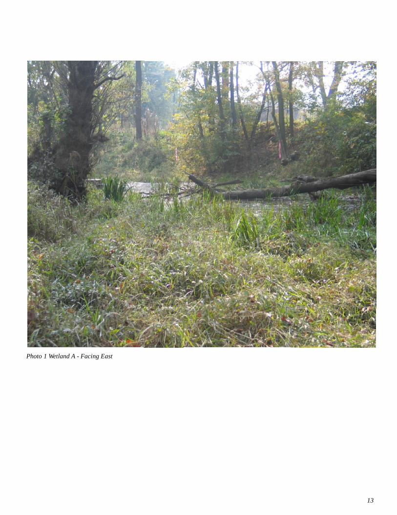
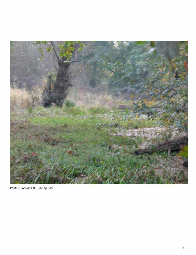
Wetland B was a 2,865.52 square meter (0.71 acre) PEM and PFO wetland. This system waslocated to the northeast of the SR 982 Bridge. The dominant emergent vegetation was common cattail(Typha latifolia), skunk cabbage (Symplocarpus foetidus), watercress (Nasturium officinale), falsenettle (Boehmeria cylindrica), soft rush (Juncus effusus), and sensitive fern (Onoclea sensibilis). Thedominant forested vegetation included sycamore (Plantanus occidentalis).
Munsell soil colors in the wetland were as follows. Matrix colors ranged from 10YR 4/1 with few andfaint mottles of 5YR 4/6. Soil textures were silty clay. The wetland soils were saturated to the surface.Apparent sources of hydrology included roadway runoff and overland flows
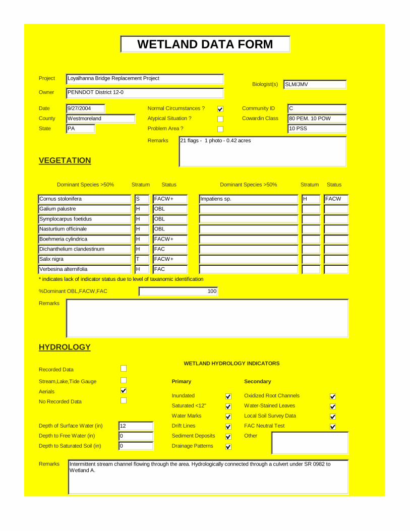
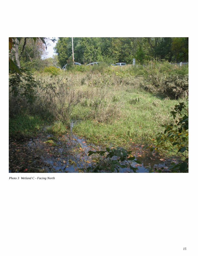
Wetland C
Wetland C was a 1,699.68 square meter (0.42 acre) PEM, PSS, and POW wetland. This systemwas located to the southwest of the SR 982 Bridge. The dominant emergent vegetation was marsh bed-straw (Galium palustre), skunk cabbage (Symplocarpus foetidus), watercress (Nasturium officinale),and false nettle (Boehmeria cylindrica). The dominant shrub vegetation included red-osier dogwood(Cornus stolonifera) and black willow (Salix nigra).
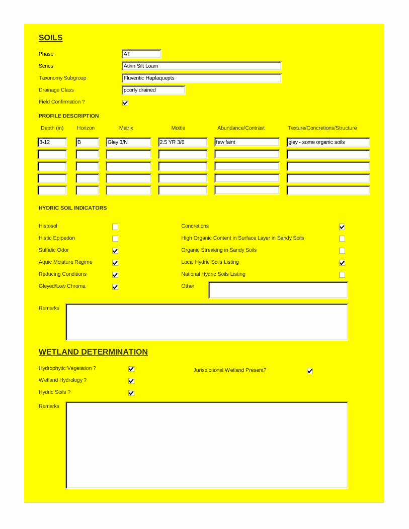
Munsell soil colors in the wetland were as follows. Matrix colors were gley 3N with few and faintmottles of 2.5YR 3/6. Soil textures were silty clay with some fill present from sewer line construction. Thewetland was inundated in 10% of its area and soils were saturated to the surface. Apparent sources ofhydrology included an intermittent stream channel.
In addition to these delineated wetland areas, instream vegetation was noted on both the east and westof the bridge within the Loyalhanna Creek bank (Refer to Photo 4). Since this area is within the definedbed and bank of the Loyalhanna Creek and the substrate was rocky and not defined as a soil, these areasare considered deep water habitats and were not delineated as a part of this report.

6
Figures

7Figure 1 Project Area Topography
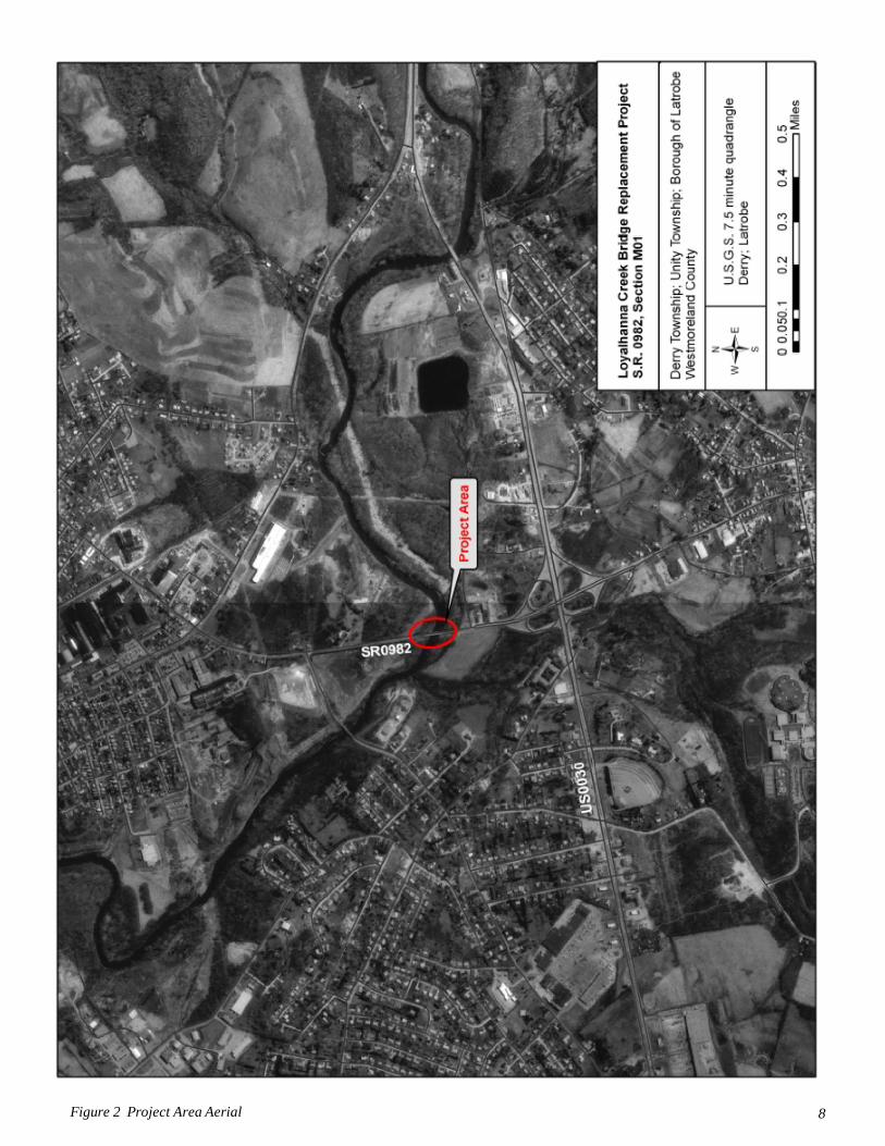
8Figure 2 Project Area Aerial

9Figure 3 Project Area Soils

10Figure 4 Project Area NWI Wetlands

11Figure 5 Project Area Wetlands

12
APPENDIX A
Wetland Data Forms, Functional Assessments, andPhotographs

Project Loyalhanna Bridge Replacement Project
Owner PENNDOT District 12-0Biologist(s) SLM/JMV
Date 9/27/2004
County Westmoreland
State PA
Normal Circumstances ?
Atypical Situation ?
Community ID A
Cowardin Class 80 PEM, 5 PFO
10 POW, 5 PSS
VEGETATION
Acorus calamus H OBL
Dichanthelium clandestinum H FAC
Symplocarpus foetidus H OBL
Nasturtium officinale H OBL
Boehmeria cylindrica H FACW+
Platanus occidentalis T FACW-
Salix nigra T FACW+
Polygonum sagittatum H OBL
Juncus effusus H FACW+
Onoclea sensibilis H FACW
Impatiens sp H FACW
Verbesina alternifolia H FAC
%Dominant OBL,FACW,FAC 100
Remarks
Recorded Data
Stream,Lake,Tide Gauge
Aerials
No Recorded Data
12
0
0
Inundated
Saturated <12"
Water Marks
Drift Lines
Sediment Deposits
Drainage Patterns
Oxidized Root Channels
Water-Stained Leaves
Local Soil Survey Data
FAC Neutral Test
Other
Remarks Intermittent stream channel flowing through the area tha connects to Wetland C through a roadway culvert.
Depth to Free Water (in)
Depth of Surface Water (in)
HYDROLOGY
Depth to Saturated Soil (in)
WETLAND HYDROLOGY INDICATORS
Primary Secondary
Problem Area ?
Dominant Species >50% Stratum Status Dominant Species >50% Stratum Status
Remarks 19 flags (left open ended to east) - 5 photos - 0.35 acres
WETLAND DATA FORM
* indicates lack of indicator status due to level of taxanomic identification

Drainage Class poorly drained
Taxonomy Subgroup Fluventic Haplaquepts
Field Confirmation ?
Depth (in)
8-12
Horizon
B
Matrix
10 YR 3/1
Mottle
5YR 5/8
Texture/Concretions/Structure
silty clay
8-12 B Gley 3/N 5YR 5/6 silty clay
Histosol
Histic Epipedon
Sulfidic Odor
Aquic Moisture Regime
Reducing Conditions
Gleyed/Low Chroma
Concretions
High Organic Content in Surface Layer in Sandy Soils
Organic Streaking in Sandy Soils
Local Hydric Soils Listing
National Hydric Soils Listing
Other
Remarks Sewer line running through area - some fill present in soil samples.
Hydrophytic Vegetation ?
Wetland Hydrology ?
Hydric Soils ?
Jurisdictional Wetland Present?
Remarks
SOILS
PROFILE DESCRIPTION
HYDRIC SOIL INDICATORS
WETLAND DETERMINATION
Abundance/Contrast
bright, few
few, faint
Phase AT
Series Atkin Silt Loam

WETLAND FUNCTIONAL ASSESSMENT EVALUATION FORMCONSIDERATIONS AND RATIONALE
WETLAND ID: A
Prepared By: SLM
Groundwater Recharge/Discharge: N
Wetland Description: Palustrine emergent, Palustrine open water
Cowardin Classification: 80 PEM, 10 POW, 5 PFO, 5 PSS
Wetland Area: 0.35
Wetland Impact:Area of Wetland Impact
Is Wetland Disturbed?
Type of Disturbance: Sewer line
Is Wetland Hydrologically Isolated?
Water Source: intermittent stream flow
Hydrodynamics: unidirectional
Hydrogeomorphic Setting: riverine (nonperennial)
Is Wetland Designated as EV?
Adjacent Land Use: forestedWatershed Size: 299 sq mileWatershed Location: low
2, 3, 5, 7, 11
FUNCTION RATIONALEHydrology is provided by an intermittent stream
COMMENTS
Floodflow Alteration: Y 1, 2, 4, 5, 7, 8, 9, 10, 12, 13, 14, 19, 21 Flood flow alteration is provided by this wetland
Sediment/Toxicant Retention: 1 1, 2, 4, 7, 8, 10, 11, 12, 13, 15, 17, 18, 19 Signs of AMD deposits were present
Nutrient Removal/Retention/Transformation N 1, 2, 3, 4, 6, 7, 8, 10, 13, 16, 17 .No known source of nutrients above wetland
Production Export: N 2, 5, 6, 7, 8, 13 No high production is evident
Streambank/Shoreline Stabilization: N 2, 5, 7, 10 Intermittent stream channel is diffuse through out wetland
Wildlife Habitat: Y 1, 4, 5, 6, 7, 9, 10, 18, 19 Signs of amphibians were present but not in large numbers.
Aquatic Habitat: Y 2, 3, 9, 10, 11, 19, 20, 21, 22 Size of wetland limits fish habitat but macroinvertebrates are present.
* - indicates that the function is being performed to a marginal degree1 - indicates the principal function being performed
PROJECT NO: 4374001
13
Photo 1 Wetland A - Facing East
Project Loyalhanna Bridge Replacement Project
Owner PENNDOT District 12-0Biologist(s) SLM/JMV
Date 9/27/2004
County Westmoreland
State PA
Normal Circumstances ?
Atypical Situation ?
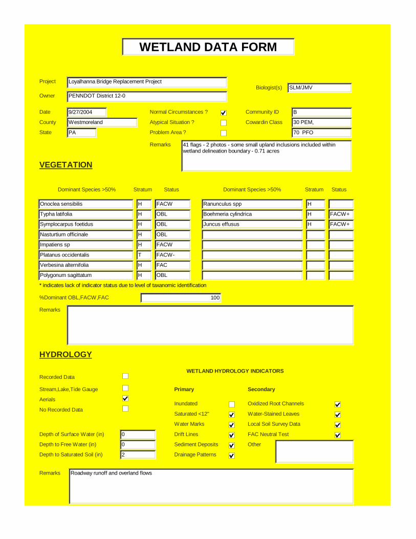
Community ID B
Cowardin Class 30 PEM,
70 PFO
VEGETATION
Onoclea sensibilis H FACW
Typha latifolia H OBL
Symplocarpus foetidus H OBL
Nasturtium officinale H OBL
Impatiens sp H FACW
Platanus occidentalis T FACW-
Verbesina alternifolia H FAC
Polygonum sagittatum H OBL
Ranunculus spp H
Boehmeria cylindrica H FACW+
Juncus effusus H FACW+
%Dominant OBL,FACW,FAC 100
Remarks
Recorded Data
Stream,Lake,Tide Gauge
Aerials
No Recorded Data
0
0
2
Inundated
Saturated <12"
Water Marks
Drift Lines
Sediment Deposits
Drainage Patterns
Oxidized Root Channels
Water-Stained Leaves
Local Soil Survey Data
FAC Neutral Test
Other
Remarks Roadway runoff and overland flows
Depth to Free Water (in)
Depth of Surface Water (in)
HYDROLOGY
Depth to Saturated Soil (in)
WETLAND HYDROLOGY INDICATORS
Primary Secondary
Problem Area ?
Dominant Species >50% Stratum Status Dominant Species >50% Stratum Status
Remarks 41 flags - 2 photos - some small upland inclusions included withinwetland delineation boundary - 0.71 acres
WETLAND DATA FORM
* indicates lack of indicator status due to level of taxanomic identification
Drainage Class poorly drained
Taxonomy Subgroup Fluventic Haplaquepts
Field Confirmation ?
Depth (in)
8-12
Horizon
B
Matrix
10 YR 4/1
Mottle
5YR4/6
Texture/Concretions/Structure
silty clay
Histosol
Histic Epipedon
Sulfidic Odor
Aquic Moisture Regime
Reducing Conditions
Gleyed/Low Chroma
Concretions
High Organic Content in Surface Layer in Sandy Soils
Organic Streaking in Sandy Soils
Local Hydric Soils Listing
National Hydric Soils Listing
Other
Remarks
Hydrophytic Vegetation ?
Wetland Hydrology ?
Hydric Soils ?
Jurisdictional Wetland Present?
Remarks
SOILS
PROFILE DESCRIPTION
HYDRIC SOIL INDICATORS
WETLAND DETERMINATION
Abundance/Contrast
few, faint
Phase AT
Series Atkin Silt Loam

WETLAND FUNCTIONAL ASSESSMENT EVALUATION FORMCONSIDERATIONS AND RATIONALE
WETLAND ID: B
Prepared By: SLM
Groundwater Recharge/Discharge: N
Wetland Description: Palustrine emergent, Palustrine forested
Cowardin Classification: 30 PEM, 70 PFO
Wetland Area: 0.71
Wetland Impact:Area of Wetland Impact
Is Wetland Disturbed?
Type of Disturbance:
Is Wetland Hydrologically Isolated?
Water Source: roadway runoff, precipitation, overland flow
Hydrodynamics: vertical
Hydrogeomorphic Setting: Depression (Open, Surface Water)
Is Wetland Designated as EV?
Adjacent Land Use: forestedWatershed Size: 299 sq mileWatershed Location: low
2, 3, 11
FUNCTION RATIONALENo signs of groundwater discharge or recharge were present
COMMENTS
Floodflow Alteration: 1 1, 2, 4, 5,6 ,7, 8, 9, 10, 13, 14, 17, 18, 19, 21 Flood flow alteration is provided by this wetland
Sediment/Toxicant Retention: Y 1, 2, 3, 4,7, 10, 11, 12, 13, 14, 15, 17, 18, 19 Sediment deposits were present
Nutrient Removal/Retention/Transformation N 1, 2, 3, 4, 6, 7, 8, 10, 13, 16, 17 .No known source of nutrients above wetland
Production Export: N 2, 5, 6, 7, 8, 13 No high production is evident
Streambank/Shoreline Stabilization: NA
Wildlife Habitat: Y 1, 4, 5, 6, 7, 9, 10, 18, 19 Signs of wildlife were present
Aquatic Habitat: N 1, 2,, 9, 15, 19, 20 No aquatic habitat was present.
* - indicates that the function is being performed to a marginal degree1 - indicates the principal function being performed
PROJECT NO: 4374001
14
Photo 2 Wetland B - Facing East
Project Loyalhanna Bridge Replacement Project
Owner PENNDOT District 12-0Biologist(s) SLM/JMV
Date 9/27/2004
County Westmoreland
State PA
Normal Circumstances ?
Atypical Situation ?
Community ID C
Cowardin Class 80 PEM. 10 POW
10 PSS
VEGETATION
Cornus stolonifera S FACW+
Galium palustre H OBL
Symplocarpus foetidus H OBL
Nasturtium officinale H OBL
Boehmeria cylindrica H FACW+
Dichanthelium clandestinum H FAC
Salix nigra T FACW+
Verbesina alternifolia H FAC
Impatiens sp. H FACW
%Dominant OBL,FACW,FAC 100
Remarks
Recorded Data
Stream,Lake,Tide Gauge
Aerials
No Recorded Data
12
0
0
Inundated
Saturated <12"
Water Marks
Drift Lines
Sediment Deposits
Drainage Patterns
Oxidized Root Channels
Water-Stained Leaves
Local Soil Survey Data
FAC Neutral Test
Other
Remarks Intermittent stream channel flowing through the area. Hydrologically connected through a culvert under SR 0982 toWetland A.
Depth to Free Water (in)
Depth of Surface Water (in)
HYDROLOGY
Depth to Saturated Soil (in)
WETLAND HYDROLOGY INDICATORS
Primary Secondary
Problem Area ?
Dominant Species >50% Stratum Status Dominant Species >50% Stratum Status
Remarks 21 flags - 1 photo - 0.42 acres
WETLAND DATA FORM
* indicates lack of indicator status due to level of taxanomic identification
Drainage Class poorly drained
Taxonomy Subgroup Fluventic Haplaquepts
Field Confirmation ?
Depth (in)
8-12
Horizon
B
Matrix
Gley 3/N
Mottle
2.5 YR 3/6
Texture/Concretions/Structure
gley - some organic soils
Histosol
Histic Epipedon
Sulfidic Odor
Aquic Moisture Regime
Reducing Conditions
Gleyed/Low Chroma
Concretions
High Organic Content in Surface Layer in Sandy Soils
Organic Streaking in Sandy Soils
Local Hydric Soils Listing
National Hydric Soils Listing
Other
Remarks
Hydrophytic Vegetation ?
Wetland Hydrology ?
Hydric Soils ?
Jurisdictional Wetland Present?
Remarks
SOILS
PROFILE DESCRIPTION
HYDRIC SOIL INDICATORS
WETLAND DETERMINATION
Abundance/Contrast
few faint
Phase AT
Series Atkin Silt Loam
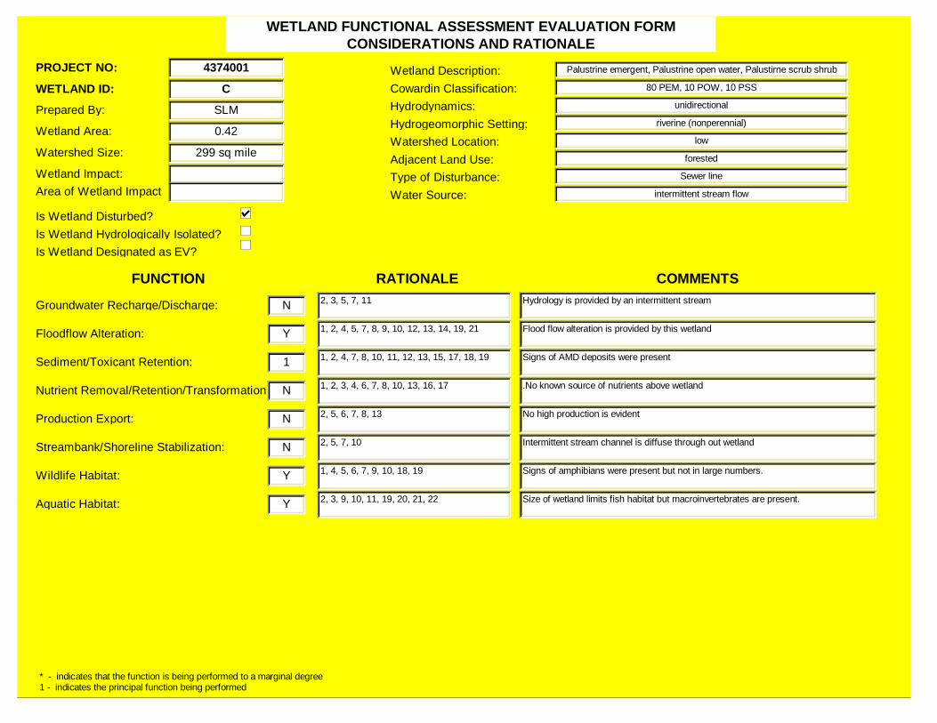
WETLAND FUNCTIONAL ASSESSMENT EVALUATION FORMCONSIDERATIONS AND RATIONALE
WETLAND ID: C
Prepared By: SLM
Groundwater Recharge/Discharge: N
Wetland Description: Palustrine emergent, Palustrine open water, Palustirne scrub shrub
Cowardin Classification: 80 PEM, 10 POW, 10 PSS
Wetland Area: 0.42
Wetland Impact:Area of Wetland Impact
Is Wetland Disturbed?
Type of Disturbance: Sewer line
Is Wetland Hydrologically Isolated?
Water Source: intermittent stream flow
Hydrodynamics: unidirectional
Hydrogeomorphic Setting: riverine (nonperennial)
Is Wetland Designated as EV?
Adjacent Land Use: forestedWatershed Size: 299 sq mileWatershed Location: low
2, 3, 5, 7, 11
FUNCTION RATIONALEHydrology is provided by an intermittent stream
COMMENTS
Floodflow Alteration: Y 1, 2, 4, 5, 7, 8, 9, 10, 12, 13, 14, 19, 21 Flood flow alteration is provided by this wetland
Sediment/Toxicant Retention: 1 1, 2, 4, 7, 8, 10, 11, 12, 13, 15, 17, 18, 19 Signs of AMD deposits were present
Nutrient Removal/Retention/Transformation N 1, 2, 3, 4, 6, 7, 8, 10, 13, 16, 17 .No known source of nutrients above wetland
Production Export: N 2, 5, 6, 7, 8, 13 No high production is evident
Streambank/Shoreline Stabilization: N 2, 5, 7, 10 Intermittent stream channel is diffuse through out wetland
Wildlife Habitat: Y 1, 4, 5, 6, 7, 9, 10, 18, 19 Signs of amphibians were present but not in large numbers.
Aquatic Habitat: Y 2, 3, 9, 10, 11, 19, 20, 21, 22 Size of wetland limits fish habitat but macroinvertebrates are present.
* - indicates that the function is being performed to a marginal degree1 - indicates the principal function being performed
PROJECT NO: 4374001
15
Photo 3 Wetland C - Facing North

16
Photo 4 Instream Vegetation - Facing East
17
References
Commonwealth of Pennsylvania. (1993). Pennsylvania Code: Title 25. Environmental Resources.Department of Environmental Resources: Chapter 93. Water Quality Standards. Commonwealth ofPennsylvania, Harrisburg, PA.
Cowardin, L.M., V. Carter, F.C. Golet, and E.T. LaRoe. (1979). Classification of Wetlands andDeepwater Habitats of the United States. U.S. Fish and Wildlife Service, Washington, DC.
Smith, R.D., Ammann, A., Bartoldus, C., and Brinson, M. M. (1995). An Approach for AssessingWetland Functions Using Hydrogeomorphic Classification, Reference Wetlands, and Functional Indices,Technical Report WRP-DE-9. U.S. Army Engineer Waterways Experiment Station, Vicksburg, MS.
United States Department of Agriculture, Soil Conservation Service (1992). Soil Survey ofWestmoreland County Pennsylvania. National Cooperative Soil Survey, Washington, D.C.
Environmental Laboratory. (1987). Corps of Engineers Wetland Delineation Manual, TechnicalReport Y-87-1. U.S. Army Engineer Waterways Experiment Station, Vicksburg, MS.