WESTMINSTER NEIGHBORHOOD AREA REDEVELOPMENT PLAN · 2015-03-04 · 1.4 NEIGHBOURHOOD BOUNDARIES AND...
53
Westminster Neighbourhood Area Redevelopment Plan Development Services Department
Transcript of WESTMINSTER NEIGHBORHOOD AREA REDEVELOPMENT PLAN · 2015-03-04 · 1.4 NEIGHBOURHOOD BOUNDARIES AND...
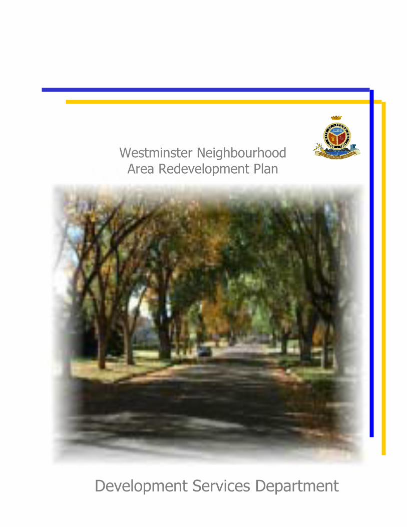
Westminster Neighbourhood Area Redevelopment Plan
Development Services Department
WESTMINSTER NEIGHBOURHOOD AREA REDEVELOPMENT PLAN
City of Lethbridge Planning and Development Department Adopted by By-law 4002 February 11, 1985 Amended by By-law 5114 August 20, 2001
TABLE OF CONTENTS
1.0 BACKGROUND TO THE WESTMINSTER NEIGHBOURHOOD A.R.P................................. 1
1.1 BACKGROUND TO ORIGINAL STUDY ....................................................................... 1
1.2 WHAT IS AN AREA REDEVELOPMENT PLAN? ........................................................ 5
1.3 THE NEIGHBOURHOOD IMPROVEMENT PROGRAM (N.I.P.) AND RESIDENTIAL REHABILITATION ASSISTANCE PROGRAM (R.R.A.P.) IN THE WESTMINSTER NEIGHBOURHOOD.............................................................. 6
1.4 NEIGHBOURHOOD BOUNDARIES AND SUB-AREAS.............................................. 6
1.5 BUILDING CONDITIONS................................................................................................ 6
1.6 NARROW LOTS.............................................................................................................. 11
1.7 RESIDENTIAL REDISTRICTINGS (REZONINGS) AND MULTI-UNIT DEVELOPMENT APPROVALS SINCE APRIL 1977................................................... 11
1.8 POPULATION COMPOSITION ..................................................................................... 11
1.9 LAND USE DESCRIPTION............................................................................................ 21
1.10 TRANSPORTATION AND PARKING ISSUES............................................................ 31
1.10.1 Crowsnest Trail............................................................................................... 31 1.10.2 2nd Avenue North........................................................................................... 35 1.10.3 5th Avenue North............................................................................................. 35 1.10.4 9th Avenue North............................................................................................. 35 1.10.5 North Mayor Magrath Drive and 23rd Street North ........................................ 36 1.10.6 13th Street North.............................................................................................. 36 1.10.7 Parking ............................................................................................................ 36 1.10.8 Bicycle/Pedestrian Routes .............................................................................. 37 1.10.9 Public Transit .................................................................................................. 37
1.11 OPEN SPACE AND COMMUNITY FACILITIES......................................................... 37
2.0 GOAL, OBJECTIVES AND POLICIES...................................................................................... 49
2.1 GOAL: TO MAINTAIN THE LOW DENSITY RESIDENTIAL CHARACTER OF THE WESTMINSTER NEIGHBOURHOOD ................................................................. 49
2.2 OBJECTIVES AND POLICIES....................................................................................... 49
3.0 IMPLEMENTATION................................................................................................................... 59
3.1 RESIDENTIAL LAND USE............................................................................................ 59
3.1.1 Redistricting Criteria....................................................................................... 59 3.1.2 Special Considerations for New Residential Development on 1stAvenue
North ............................................................................................................... 69 3.1.3 Low Density (R-L District)............................................................................. 73 3.1.4 Property Maintenance and Rehabilitation....................................................... 77
3.2 COMMERCIAL LAND USE........................................................................................... 77
3.2.1 Continued Commercial Activity ..................................................................... 77 3.2.2 Limited Commercial Expansion ..................................................................... 77 3.2.3 Commercial Parking Requirements ................................................................ 77
3.3 OPEN SPACE................................................................................................................... 78
3.3.1 Accessibility to Open Space ........................................................................... 78 3.4 TRANSPORTATION....................................................................................................... 79
3.4.1 Public Transit .................................................................................................. 79 3.4.2 Bicycle Routes ................................................................................................ 79 3.4.3 2nd Avenue North ............................................................................................ 79 3.4.4 5th Avenue North............................................................................................. 79
4.0 LAND USE BY-LAW RELATIONSHIP .................................................................................... 81
4.1 CONCURRENT AMENDMENTS .................................................................................. 81
4.2 STATUTORY PLAN OVERLAY ................................................................................... 81
4.3 RELATIONSHIP OF THE NEW LAND USE BY-LAW TO THE WESTMINSTER NEIGHBOURHOOD AREA REDEVELOPMENT PLAN. ........................................... 81
LIST OF TABLES Table 1 Development Applications From April 1977 to April 1984........................................... 13 Table 2 Population Summary....................................................................................................... 17 Table 3 Westminster Population by Age Groups ........................................................................ 23 Table 4 Comparison of Population Age Structure: Westminster Neighbourhood and City of Lethbridge .................................................................................................... 23
LIST OF FIGURES
Figure 1 Original Westminster Boundaries and Sub-areas …………………………………. 3Figure 2 Proposed Westminster Boundaries and Sub-areas ………………………………... 7Figure 3 Building Conditions ………………………………………………………………. 9Figure 4 Multi Unit Dwellings: Development Approvals since April, 1977 ……………… 15Figure 5 Municipal Enumeration Districts Showing Significant Population Changes
Between 1976-1983 ……………………………………………………………….. 19Figure 6 Population Pyramids ……………………………………………………………… 25Figure 7 Land Use Districts ………………………………………………………………… 27Figure 8 Existing Land Use ………………………………………………………………… 29Figure 9 Major Roadways ………………………………………………………………….. 33Figure 10 Bicycle Routes …………………………………………………………………….. 39Figure 11 Public Transit Routes ……………………………………………………………... 41Figure 12 Open Space ………………………………………………………………………... 43Figure 13 Open Space Accessibility …………………………………………………………. 47Figure 14 Redistricting Criteria: (i) Roadway Travelling Surface Widths ………………….. 61Figure 15 Redistricting Criteria: (ii) Transitional Areas ……………………………………. 65Figure 16 Redistricting Criteria: (iii) Residential Blocks Meeting Building Conditions
Criterion …………………………………………………………………………... 67Figure 17 Potential Redistricting Areas ……………………………………………………… 71Figure 18 Westminster Land Use Districts ………………………………………………….. 75
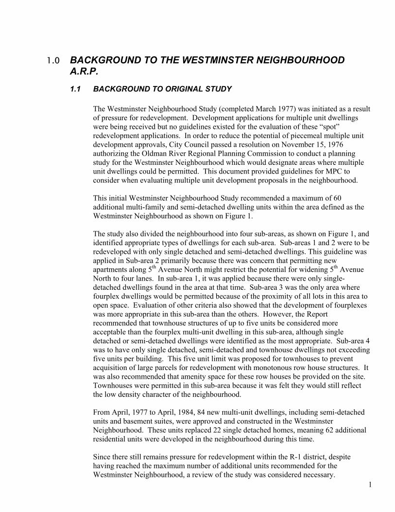
1.0 BACKGROUND TO THE WESTMINSTER NEIGHBOURHOOD A.R.P. 1.1 BACKGROUND TO ORIGINAL STUDY
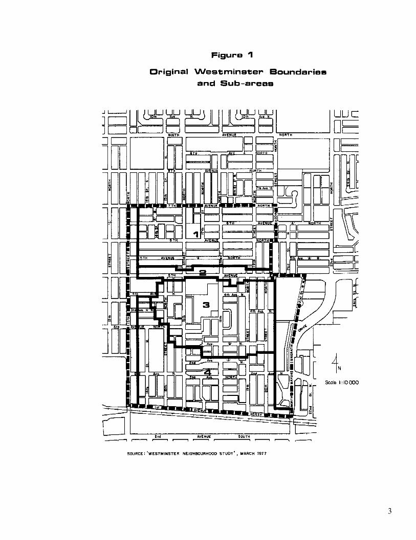
The Westminster Neighbourhood Study (completed March 1977) was initiated as a result of pressure for redevelopment. Development applications for multiple unit dwellings were being received but no guidelines existed for the evaluation of these “spot” redevelopment applications. In order to reduce the potential of piecemeal multiple unit development approvals, City Council passed a resolution on November 15, 1976 authorizing the Oldman River Regional Planning Commission to conduct a planning study for the Westminster Neighbourhood which would designate areas where multiple unit dwellings could be permitted. This document provided guidelines for MPC to consider when evaluating multiple unit development proposals in the neighbourhood. This initial Westminster Neighbourhood Study recommended a maximum of 60 additional multi-family and semi-detached dwelling units within the area defined as the Westminster Neighbourhood as shown on Figure 1. The study also divided the neighbourhood into four sub-areas, as shown on Figure 1, and identified appropriate types of dwellings for each sub-area. Sub-areas 1 and 2 were to be redeveloped with only single detached and semi-detached dwellings. This guideline was applied in Sub-area 2 primarily because there was concern that permitting new apartments along 5th Avenue North might restrict the potential for widening 5th Avenue North to four lanes. In sub-area 1, it was applied because there were only single-detached dwellings found in the area at that time. Sub-area 3 was the only area where fourplex dwellings would be permitted because of the proximity of all lots in this area to open space. Evaluation of other criteria also showed that the development of fourplexes was more appropriate in this sub-area than the others. However, the Report recommended that townhouse structures of up to five units be considered more acceptable than the fourplex multi-unit dwelling in this sub-area, although single detached or semi-detached dwellings were identified as the most appropriate. Sub-area 4 was to have only single detached, semi-detached and townhouse dwellings not exceeding five units per building. This five unit limit was proposed for townhouses to prevent acquisition of large parcels for redevelopment with monotonous row house structures. It was also recommended that amenity space for these row houses be provided on the site. Townhouses were permitted in this sub-area because it was felt they would still reflect the low density character of the neighbourhood.
From April, 1977 to April, 1984, 84 new multi-unit dwellings, including semi-detached units and basement suites, were approved and constructed in the Westminster Neighbourhood. These units replaced 22 single detached homes, meaning 62 additional residential units were developed in the neighbourhood during this time.
1
Since there still remains pressure for redevelopment within the R-1 district, despite having reached the maximum number of additional units recommended for the Westminster Neighbourhood, a review of the study was considered necessary.
3
On March 29, 1982, City Council passed the following resolution: “Resolved that the Planning Department undertake a comprehensive review and update of the Westminster Neighbourhood Land Use Study and further that the study identify sub-region areas within the Westminster Neighbourhood requiring more detailed study and further that alternative development strategies for these sub-regions be examined and recommendations prepared and further that this review be presented to Council for its consideration.”
1.2 WHAT IS AN AREA REDEVELOPMENT PLAN? The Alberta Planning Act, 1980 is the fundamental guide for planning in the province. One of the provisions of the Act permits municipalities to designate areas for redevelopment, and adopt redevelopment plans for those areas, for any or all of the following purposes:
1. preserving or improving land and buildings 2. rehabilitating buildings 3. removing buildings 4. constructing or replacing buildings 5. establishing, improving or relocating public roadways, public utilities or other
services 6. any other development in the area1
Further provisions of the Act require the area redevelopment plan to conform to the land use by-law and any other statutory plan affecting the area (i.e. the general municipal plan). The area redevelopment plan must describe: 1. the objectives and how they are to be achieved 2. the proposed land uses 3. the proposed public roadways, public utilities and other services 4. the location of any municipal and/or school reserve land 5. any recreational and school facilities 6. any proposals to acquire land for public municipal use, for school facilities, for parks
and recreation facilities, or for other purposes considered necessary 7. any other proposals considered necessary2 The Westminster Neighbourhood is subject to redevelopment pressures and requires an area redevelopment plan to provide the level of detail necessary to deal effectively with these pressures. The Plan has been prepared according to the provisions set out in the Planning Act and the requirements identified for this Plan by City Council in March 1982.
1 Section 65 (a) of the Planning Act, 1980
52 Section 67(b) and (d) of the Act
1.3 THE NEIGHBOURHOOD IMPROVEMENT PROGRAM (N.I.P.) AND RESIDENTIAL REHABILITATION ASSISTANCE PROGRAM (R.R.A.P.) IN THE WESTMINSTER NEIGHBOURHOOD
The Neighbourhood Improvement Program (N.I.P.) was originally established by the federal government to allow municipalities to improve neighbourhoods by utilizing funds towards improving neighbourhood facilities, including utilities and recreational facilities. Designation of the Westminster Neighbourhood as a N.I.P. area was made by City Council resolution in April, 1975. The N.I.P. boundaries also served to identify the homes that could be considered for rehabilitation through the use of another federal government program, the Residential Rehabilitation Assistance Program (R.R.A.P.). As of October, 1976, R.R.A.P. funding was available to those property owners who wanted to upgrade and rehabilitate their homes. The Westminster Neighbourhood’s N.I.P. funds were used to replace the former Lions Pool with the new Westminster pool and community centre, while R.R.A.P. has helped preserve many single detached homes in the Westminster Neighbourhood. Housing rehabilitation through R.R.A.P. assistance is complete on 270 homes; 73 in 1977, 105 in 1978, 24 in 1979, 27 in 1980, 20 in 1981, 9 in 1982, and 12 more as of April, 1984.
1.4 NEIGHBOURHOOD BOUNDARIES AND SUB-AREAS
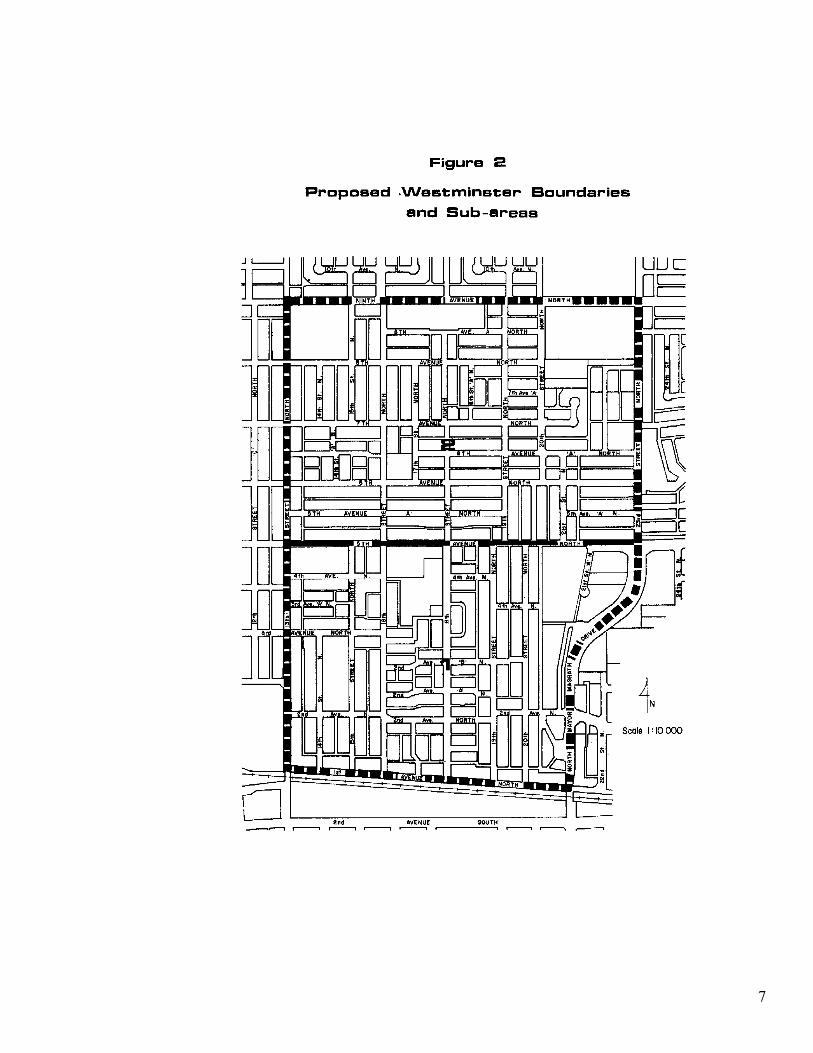
Some modifications to the boundaries of the Westminster Neighbourhood as defined in the 1977 study, have been made in this Area Redevelopment Plan. All analysis and recommendations in this Plan refer to the new neighbourhood boundaries. The C.P.R. right-of-way and 13th Street North continue to be the southern and western limits respectively, of the neighbourhood. The northern boundary has been extended to 9th Avenue North and the eastern boundary to North Mayor Magrath Drive and 23rd Street North, as shown on Figure 2. These boundaries were selected because arterial (North Mayor Magrath Drive) and collector (9th Avenue North) traffic routes are logical boundaries for a neighbourhood since they limit access between areas on opposite sides of the route. Similarly, 5th Avenue North is a major traffic route which separates the neighbourhood into two distinct sub-areas, as shown on Figure 2. These two sub-areas will be referred to throughout the Plan. The characteristics of each sub-area will be discussed in the background material and given consideration in the Plan.
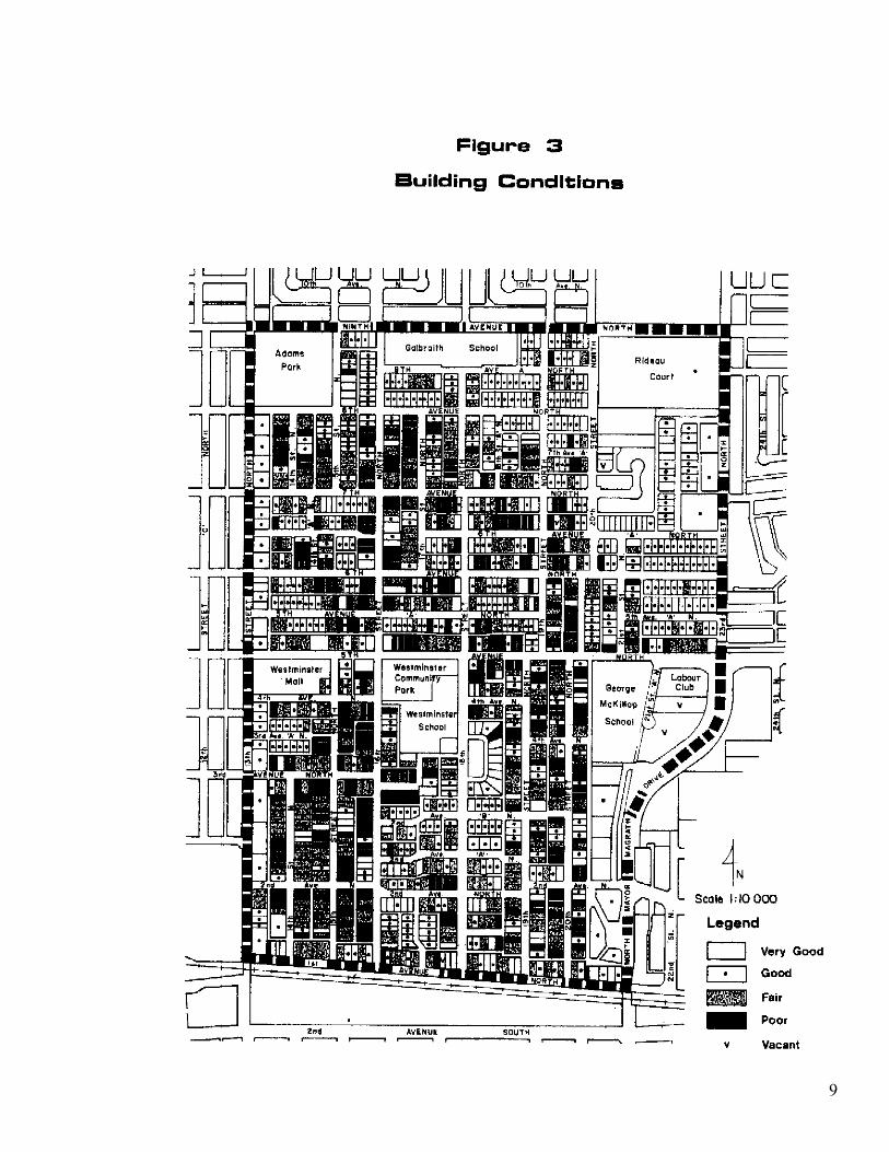
1.5 BUILDING CONDITIONS
A windshield survey of building conditions in the Westminster Neighbourhood completed between February 20 and 22, 1984 found about half of the homes in the neighbourhood to be in fair or poor condition. The results of this survey are illustrated on Figure 3. The results indicate that there are many properties in the neighbourhood where redevelopment may be appropriate due to the deteriorated condition of the housing stock.
6
7
9
1.6 NARROW LOTS
The majority of lots in the Westminster Neighbourhood do not meet current lot size requirements of the Land Use By-law. Many of these have frontages of 7.6 m or 9.1 m while the current minimum lot width in R-1 districts under the Land Use By-law is 10.7m.
1.7 RESIDENTIAL REDISTRICTINGS (REZONINGS) AND MULTI-UNIT DEVELOPMENT APPROVALS SINCE APRIL 1977
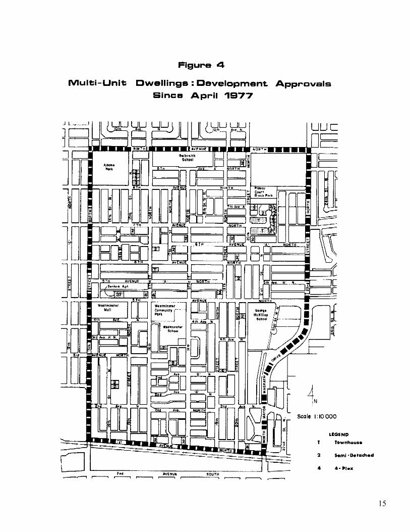
Based on development applications since 1977, (when the original study was completed) sub-area 2 appears to be receiving more development pressure than sub-area 1, as shown on Table 1. Figure 4 shows the location of new multi-unit developments completed between April, 1977 and April, 1984. It should be noted that 50 multiple dwelling units approved north of 5th Avenue North were not infill but part of a new subdivision. However, even without counting these units, the total number of units applied for in sub-area 2 was almost twice as high as the number applied for in sub-area 1. Also, six redistricting (re-zoning) applications were made in sub-area 2, one of which was refused. The approvals accounted for 95 new units and the refusal was for a 6-unit proposal. In sub-area 1, there were four rezoning applications of which three were refused for proposals totalling 20 units. The site that was approved was intended for four units.
1.8 POPULATION COMPOSITION
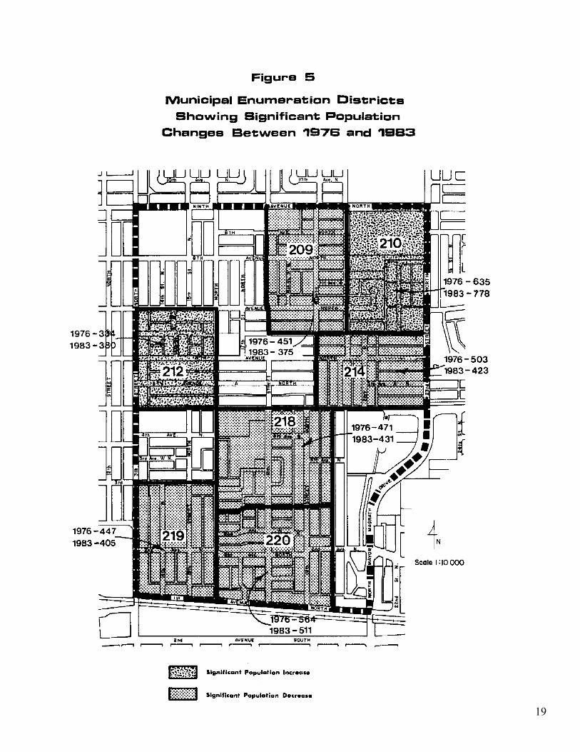
The 1983 Municipal Census shows the population of the Westminster Neighbourhood to be 4,774. Between 1976 and 1981 the population of the area decreased by 164 people, but between 1981 and 1983 it recovered partially, increasing by 90 persons or approximately 1.92%. Table 2 identifies the neighbourhood’s recent population changes. Table 2 shows that sub-area 1 has shown a decline in population between 1976 and 1983, while sub-area 2 increased its total population. There were significant declines in the population of five of the eleven census districts in the neighbourhood between 1976 and 1983, which were partially offset by increases in two census districts in sub-area 2, as shown on Figure 5. The districts that showed increases in their population also had a relatively high number of recently completed multi-unit dwellings. In census district 212, a 32 unit Senior Citizen’s apartment was constructed while in census district 210, 27 townhouse units and 22 semi-detached units were developed between 1977 and 1981.
11
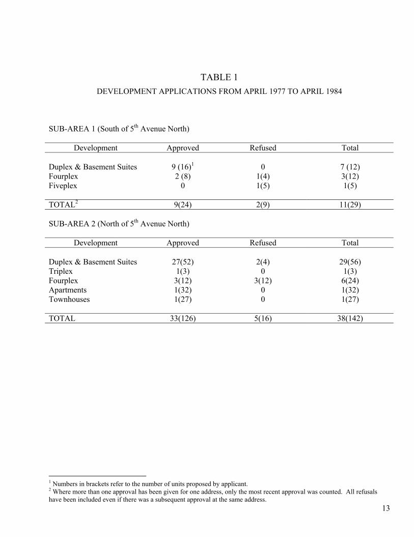
TABLE 1 DEVELOPMENT APPLICATIONS FROM APRIL 1977 TO APRIL 1984
SUB-AREA 1 (South of 5th Avenue North)
Development Approved Refused Total Duplex & Basement Suites
9 (16)1
0
7 (12)
Fourplex 2 (8) 1(4) 3(12) Fiveplex
0 1(5) 1(5)
TOTAL2 9(24) 2(9) 11(29) SUB-AREA 2 (North of 5th Avenue North)
Development Approved Refused Total Duplex & Basement Suites
27(52)
2(4)
29(56)
Triplex 1(3) 0 1(3) Fourplex 3(12) 3(12) 6(24) Apartments 1(32) 0 1(32) Townhouses
1(27) 0 1(27)
TOTAL 33(126) 5(16) 38(142)
1 Numbers in brackets refer to the number of units proposed by applicant.
13
2 Where more than one approval has been given for one address, only the most recent approval was counted. All refusals have been included even if there was a subsequent approval at the same address.
15
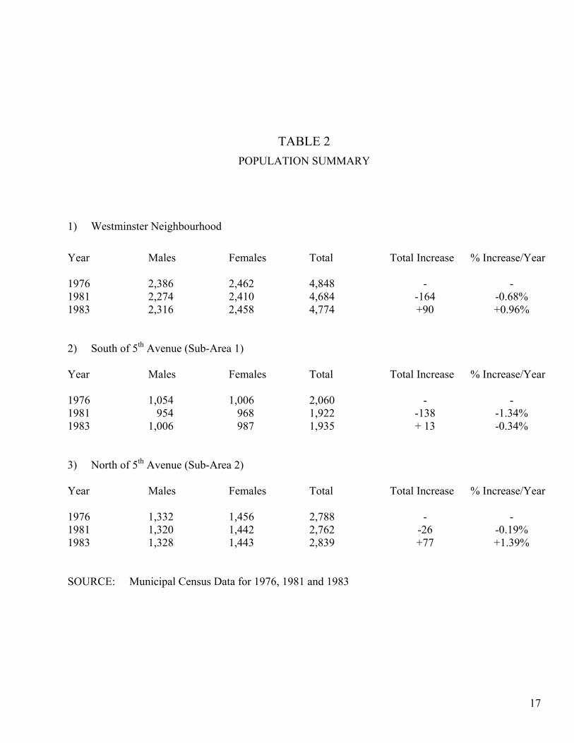
TABLE 2 POPULATION SUMMARY
1) Westminster Neighbourhood
Year Males Females Total Total Increase % Increase/Year 1976 2,386 2,462 4,848 - - 1981 2,274 2,410 4,684 -164 -0.68% 1983 2,316 2,458 4,774 +90 +0.96% 2) South of 5th Avenue (Sub-Area 1) Year Males Females Total Total Increase % Increase/Year 1976 1,054 1,006 2,060 - - 1981 954 968 1,922 -138 -1.34% 1983 1,006 987 1,935 + 13 -0.34% 3) North of 5th Avenue (Sub-Area 2) Year Males Females Total Total Increase % Increase/Year 1976 1,332 1,456 2,788 - - 1981 1,320 1,442 2,762 -26 -0.19% 1983 1,328 1,443 2,839 +77 +1.39% SOURCE: Municipal Census Data for 1976, 1981 and 1983
17
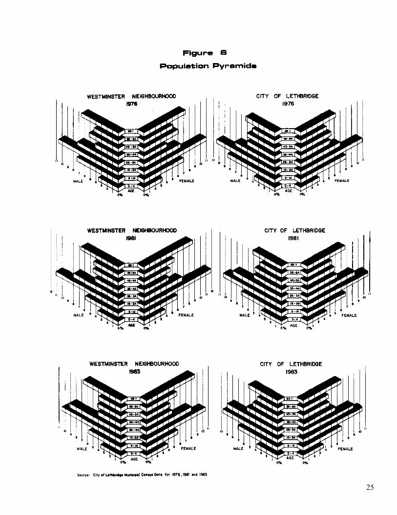
19
The overall decrease in the Westminster Neighbourhood’s population between 1976 and 1983 was reflected by significant decreases in numbers in the 5 – 14 and 45 – 54 age groups, as shown on Table 3. Most of these decreases occurred between 1976 and 1981. The population declines between 1976 and 1983 were partially offset by increases in the 0-4, 25-34 and 65 plus age categories.
Table 4 and Figure 6 illustrate how the population structure of the neighbourhood has changed between 1976 and 1983. The City’s population structure is shown for comparison. It is important to note that the proportion of those 55 and over has been significantly higher in the neighborhood than the City since 1976.
1.9 LAND USE DESCRIPTION
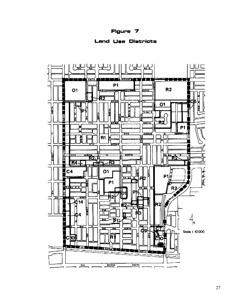
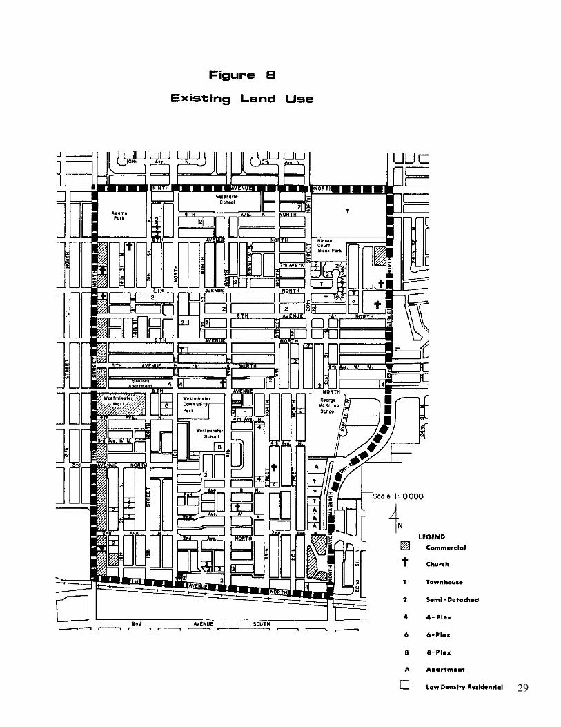
The present land use districting of the City’s Land Use By-Law 3574 for the Westminster Neighbourhood is shown on Figure 7. Figure 7 illustrates the dominance of the R-1 district in the neighbourhood and also shows where isolated parcels have been zoned at higher densities. There are approximately 1330 single detached dwellings in the neighbourhood including approximately 190 homes with basement suites. Forty-three semi-detached dwellings (86 units) are also found in the neighbourhood. The locations of these semi-detached dwellings and other multi-unit dwellings, including fourplexes and apartments, are shown on Figure 8, Existing Land Use. The highest density development in the neighbourhood is the Senior Citizens’ Apartment located on 5th Avenue North just east of 13th Street North. This is shown as R-4 on the Land use Districts Map (Figure 7). Commercial development is found primarily along 13th Street North and in the Westminster Mall on 5th Avenue North. There are also two pockets of commercial development in the eastern portion of the study area, and a small convenience store opposite Westminster School. The 13th Street North commercial area supplies a wide variety of goods and services that generally would not be found in a neighbourhood commercial district in the City. Businesses on 13th Street North serve neighbourhood residents as well as a broader trade area encompassing the entire City. There are nine churches representing nine different denominations in the neighbourhood, as shown on Figure 8. There are three school sites in the neighbourhood, including Galbraith School on 8th Avenue “A” North, Westminster School at 402 – 18th Street North, and George McKillop Curriculum Centre at 5th Avenue North and 21st Street “A” North. Galbraith and Westminster Public Schools offer a regular school curriculum while George McKillop is used as a multi-purpose education centre, used by various organizations.
21
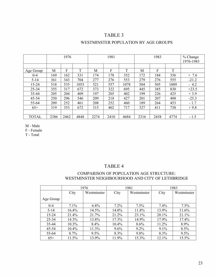
TABLE 3 WESTMINSTER POPULATION BY AGE GROUPS
1976 1981 1983 % Change 1976-1983
Age Group M F T M F T M F T
0-4 169 162 331 174 178 352 172 184 356 + 7.6 5-14 361 343 704 277 276 553 279 276 555 -21.2
15-24 518 535 1053 521 557 1078 504 505 1009 - 4.2 25-34 355 317 672 373 322 695 445 385 830 +23.5 35-44 205 204 409 197 205 402 199 226 425 + 3.9 45-54 250 296 546 209 218 427 201 207 408 -25.3 55-64 209 252 461 208 252 460 189 264 453 - 1.7 65+ 319 353 672 315 402 717 327 411 738 + 9.8
TOTAL 2386 2462 4848 2274 2410 4684 2316 2458 4774 - 1.5
M - Male F - Female T - Total
TABLE 4 COMPARISON OF POPULATION AGE STRUCTURE:
WESTMINSTER NEIGHBOURHOOD AND CITY OF LETHBRIDGE
1976 1981 1983
Age Group City Westminster City Westminster City Westminster
0-4 7.1% 6.8% 7.2% 7.5% 7.4% 7.5% 5-14 16.4% 14.5% 14.0% 11.8% 13.9% 11.6%
15-24 21.4% 21.7% 21.2% 23.1% 20.1% 21.1% 25-34 14.3% 13.8% 17.3% 14.9% 17.9% 17.4% 35-44 10.3% 8.4% 10.4% 8.6% 11.2% 8.9% 45-54 10.4% 11.3% 9.6% 9.2% 9.1% 8.5% 55-64 8.7% 9.5% 8.3% 9.8% 8.3% 9.5% 65+ 11.5% 13.9% 11.9% 15.3% 12.1% 15.5%
23
25
27
29
In the George McKillop Curriculum Centre, the Christian School uses two classrooms, two rooms are used as a media centre, the Alberta Teachers Association (A.T.A.) has an office, there is one conference room available, the Y.M.C.A. has a pre-school program and Lethbridge Pre-school services has a kindergarten in the remaining space. The School Board also has some office space in this building. On July 20, 1983, the Lethbridge Montessori School (day care centre) received approval for use of a portion of the building. Future uses that have been considered for George McKillop School include the provision of classrooms for children from the Valleyview/Uplands area until a school is built in that area. This school may also be used as a teachers’ centre. The Lethbridge School District’s (No.51) School Facilities Utilization Plan (March, 1983) has indicated that this building could be used for one grade (two classrooms) from Westminster School for the next five to six years.
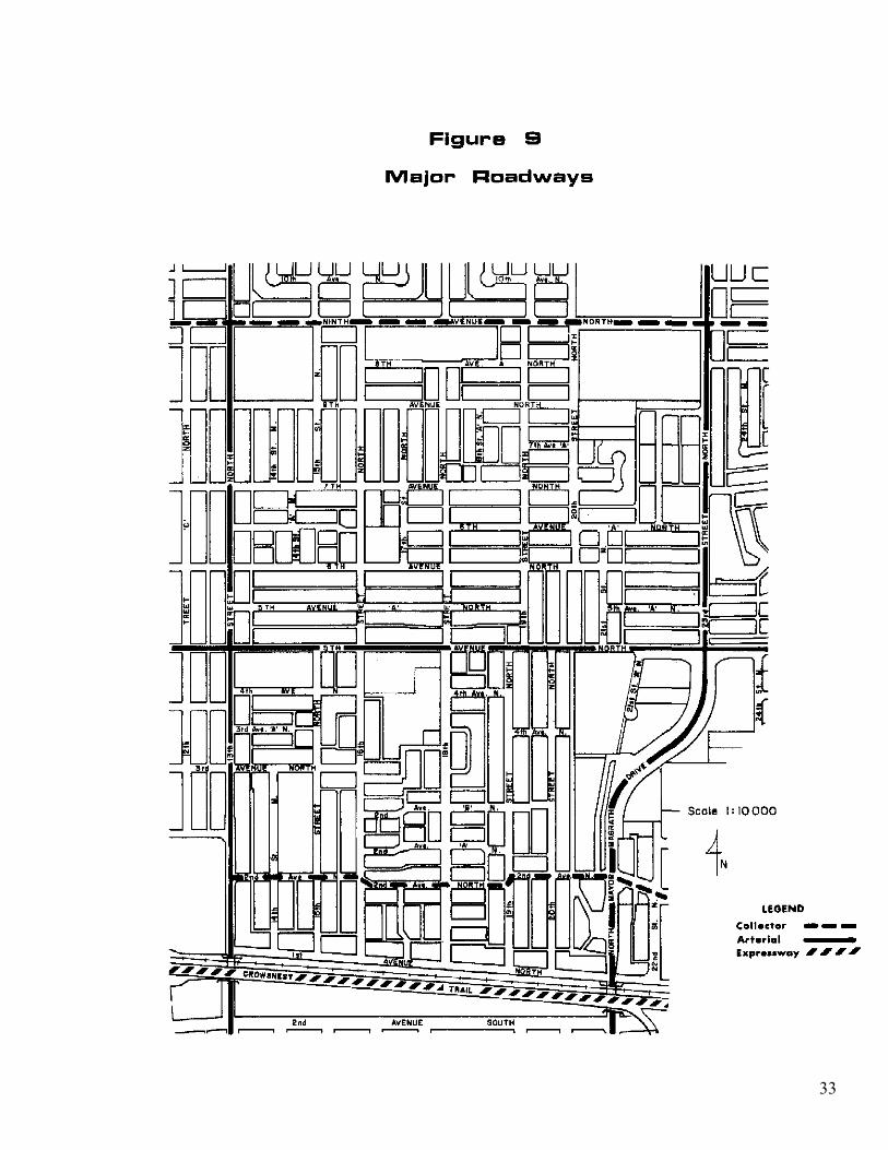
1.10 TRANSPORTATION AND PARKING ISSUES All major roads (expressways, arterials and collectors) in the Westminster Neighbourhood are shown on Figure 9, Major Transportation Routes. For the purposes of this Plan, “major road” refers to the Crowsnest Trail (Expressway), 2nd Avenue North (collector), 5th Avenue North (arterial), 9th Avenue North (collector), North Mayor Magrath Drive/23rd Street North (arterial), and 13th Street North (arterial).
1.10.1 Crowsnest Trail The Crowsnest Trail will lie to the south of the neighbourhood, parallel and adjacent to the C.P.R. right-of-way. Traffic leaving the Crowsnest Trail for North Lethbridge will exit onto North Mayor Magrath Drive and Stafford Drive. A westbound to northbound exit ramp is also planned for 13th Street North. Traffic exiting North Mayor Magrath Drive to enter the Westminster Neighbourhood south of 5th Avenue North will likely do so onto 2nd Avenue North. Traffic destined for sub-area 2 can use several avenues, which intersect with 23rd Street North. Without an interchange at 13th Street North, traffic volumes could increase on 2nd Avenue North and 5th Avenue North since westbound Crowsnest Trail traffic destined for the Centre Village Mall or the commercial area along 13th Street North, would have to exit at North Mayor Magrath Drive and travel west on 2nd Avenue North or 5th Avenue North to 13th Street. Currently, Highway 3 traffic destined for these locations is more likely to follow 3rd Avenue South from Mayor Magrath Drive to 13th Street. In addition to the impact of the Trail on traffic volumes on neighbourhood roads, the traffic noise that may be generated by the Crowsnest Trail and the railway could have some impact on the southern portions of the neighbourhood, particularly for those lots fronting 1st Avenue North. Based on projected traffic volumes on the Crowsnest Trail to 2001 and train traffic expected on the railway, outdoor noise levels may be as high as 65 dB(A). The City’s standard for maximum acceptable outdoor noise levels in a residential area is 60 dB(A).
31
33
1.10.2 2nd Avenue North
This road has been designed as a local road yet if often carries traffic volumes similar to a collector because it serves as a direct link between North Mayor Magrath Drive and 13th Street North. Due to these traffic volumes, it has been classed as a major road (collector) in the neighbourhood, as identified on Figure 9.
1.10.3 5th Avenue North
Due to the traffic volumes forecast for 5th Avenue North, the widening of this road has been recommended in the Lethbridge Transportation Study (Draft), 1984 for a time when the City’s population is between 65,000 and 76,000 (projected to occur between 1986 and 1996). This has been considered in the past but for two reasons, there has been some pressure to prevent its widening. First, the location of two schools and a recreation centre adjacent to 5th Avenue North requires consideration for the safety of young children. Traffic is currently restricted to a maximum speed of 30 km/hour through the school zones during school hours, and 30 km/hour past the Westminster Community Park from 8:30 a.m. to one hour after sunset, reducing the road’s capability to function as an efficient arterial. Second, the widening of 5th Avenue North would require the prohibition of access to fronting lots from the roadway. From a transportation viewpoint, 5th Avenue North is a good location for an arterial across the north side of the City. It currently carries relatively high traffic volumes because it is a travel desire line for many local drivers and is a direct route to and from Highway #3 at the west end of the City. The Land Use By-law has a special setback requirement of 1.4 m for any new development on either side of 5th Avenue North in addition to the standard front yard setback. This special setback, which is applied to new developments, was designed to facilitate a future widening of 5th Avenue North, when and if this is approved.
1.10.4 9th Avenue North
Ninth Avenue North is currently classified as a 2 lane collector road despite having a wider paved surface and right-of-way than 5th Avenue North. It is unlikely that this roadway will be upgraded to an arterial. There are three schools and a park situated on 9th Avenue North between 13th Street North and 23rd Street North, resulting in speed limitations, which impede traffic flows.
35
1.10.5 North Mayor Magrath Drive and 23rd Street North
North Mayor Magrath Drive becomes 23rd Street North at a four-way intersection at 5th Avenue North. These two roads function as a major north-south arterial. One future change to be completed on this arterial roadway is the construction of an interchange with the Crowsnest Trail. The widening of 23rd Street North to a four lane undivided arterial has been proposed in the Lethbridge Transportation Study (Draft Report), 1984 for a time when the City’s population is somewhere between 65,500 and 76,000.
1.10.6 13th Street North
Within the Westminster Neighbourhood, 13th Street North is a 4-lane divided arterial between 1st Avenue and 2nd Avenue “A” North and a 4-lane undivided arterial from 2nd Avenue “A” North to 8th Avenue North. Between 8th Avenue North and 9th Avenue North, there are two lanes for northbound traffic and one lane for southbound traffic. It is expected that 13th Street North will have to be widened to accommodate projected increases in traffic volumes on this roadway. In order to accommodate a wider road right-of-way, the City’s Land Use By-law requires a 2.1 m setback for all new development on either side of 13th Street North. This setback is in addition to regular setback requirements and is intended to facilitate a widening of 13th Street North.
1.10.7 Parking
In 1983, Council agreed to purchase a lot at 519 – 13th Street North to supply 18 angled parking stalls. These parking stalls replaced on-street parking stalls that were removed from 13th Street North between 5th Avenue North and 8th Avenue North to improved traffic flows. While the current supply of parking stalls may be sufficient for most commercial areas in the neighbourhood, regular monitoring of the parking supply could be necessary. A review of parking requirements along 13th Street North will be particularly important if further road improvements on 13th Street North lead to the removal of more on-street parking.
36
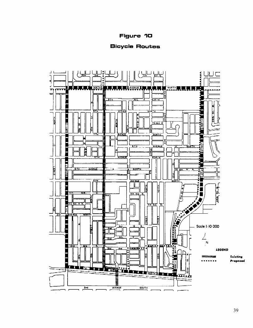
1.10.8 Bicycle/Pedestrian Routes
A Bicycle Routes report completed in 1980 by the Engineering Directorate identified existing bicycle routes in the City and also proposed new routes. These routes were approved in principle by City Council, with decisions on implementation being deferred. The routes found in and proposed for the Westminster Neighbourhood are shown on Figure 10. Two of these routes will use the 17th Street overpass to cross the railway and Crowsnest Trail.
1.10.9 Public Transit
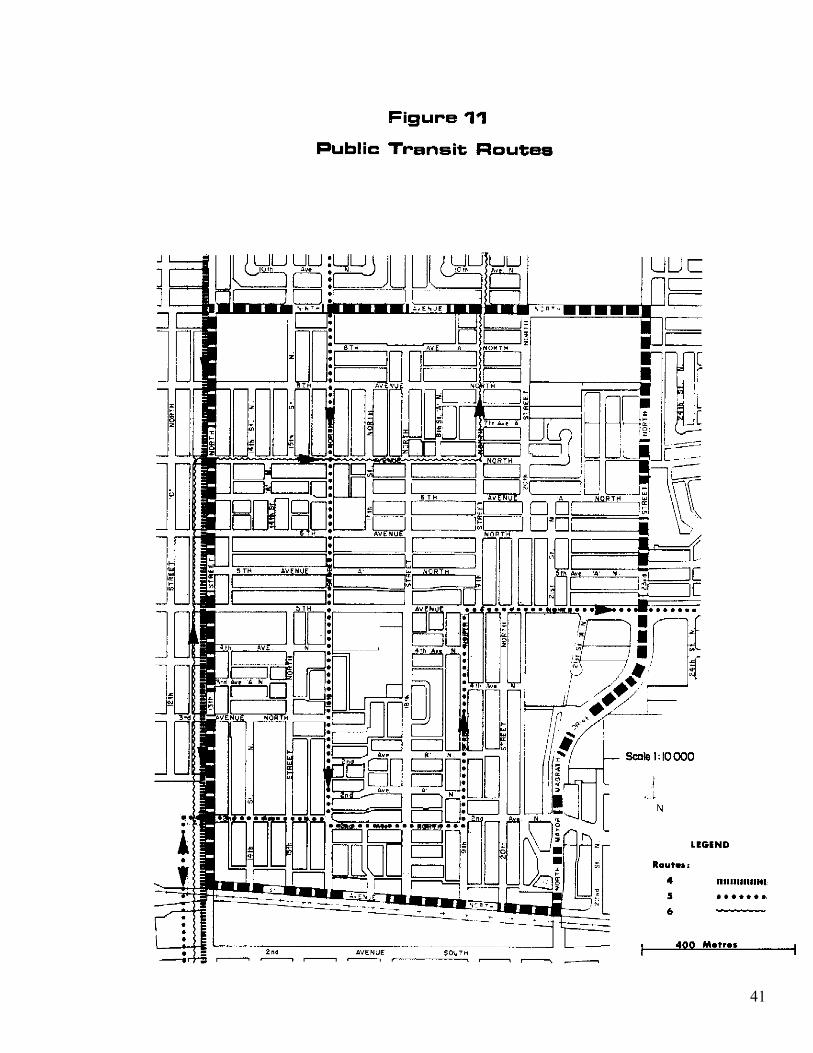
Figure 11 shows the location of the existing transit routes in the neighbourhood. Current City policy recommends transit service be provided within 300 metres (400 metres maximum walking distance) of all passenger origins and destinations. The policy being recommended in the “Lethbridge Transportation Study (Draft), 1984” calls for regular transit service to be provided within 400 metres walking distance of at least 95 per cent of all residences, major concentrations of work and public services and facilities. While one-way transit service is adequate, two-way service is preferred. In addition, the report entitled, “A Strategy for Energy Efficient Residential Land Use for the City of Lethbridge”, noted that a transit system is most efficient when higher densities are closest to the routes with lower density developments graduating outward. Based on the recommendations of these reports and the location of transit service in the Westminster Neighbourhood, transit service in the neighbourhood could be improved if more two-way routes were provided and if most new multi-unit developments in the neighbourhood could be located as close to these routes as possible, taking into account other locational criteria such as access to open space and impact on the character of the neighbourhood. While route changes have been proposed in the Lethbridge Transportation Study (Draft), 1984, these have not yet been approved.
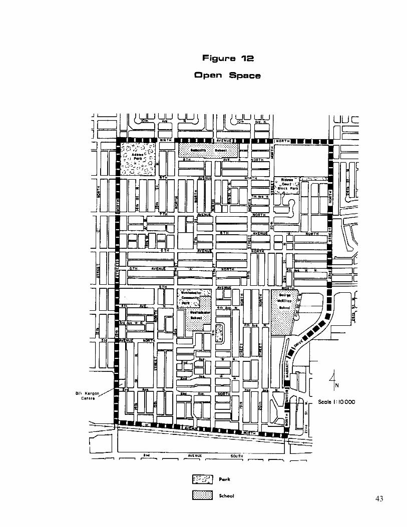
1.11 OPEN SPACE AND COMMUNITY FACILITIES
Existing open space and school sites in the neighbourhood are shown on Figure 12. Open space in sub-area 1 is located adjacent to 5th Avenue North. The Westminster Community Centre is at the north end of sub-area 1 but central to the whole neighbourhood. The facilities found in the Community Centre and park include a community room, swimming pool, tennis courts, play equipment and volleyball facilities. The community room is used by different neighbourhood groups, which run various programs from the hall. As a secondary use, this hall is also rented periodically for private functions. Westminster School, adjacent to the community centre, has two ball diamonds and a sports field. Further east on 5th Avenue North between 20th Street North and 21st Street “A” North, the George McKillop School site provides additional open
37
39
41
43
space. This open space contains a sportsfield, two ball diamonds, and a soccer field. There also is some play equipment on a private vacant lot, which accommodates some of the demand for play areas south of 2nd Avenue North. However, if this property is redeveloped, there may be no play areas south of 2nd Avenue North unless a parcel is purchased and redeveloped specifically as open space.
The recently developed Bill Kergan Centre (the former Labour Club building) is also becoming a focus for community activity within the Westminster Neighbourhood. Office space in the Centre is currently occupied by eight different community groups who also have access to boardrooms, a multi-purpose room and kitchen facilities. In the evenings, the multi-purpose room and kitchen facilities are available for private bookings such as wedding receptions or community meetings. The Centre is located on the north-east corner of 2nd Avenue North and 13th Street North. There are three open space areas in sub-area 2. Recreation facilities found in the Adams Community Park include an ice arena, play equipment, and an open play area. Facilities found in the Rideau Court Block Park include play equipment, a play lot sandbox, outdoor basketball court and an open play area. Galbraith School has an open play area and ball diamonds.
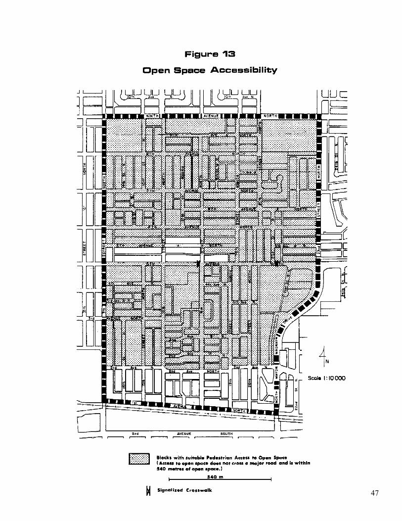
The Open Space Plan (unadopted), 1981 for the City of Lethbridge identified a block park service radius standard of 540 metres (1/3 mile) provided access to the park does not cross a major road (collector or arterial). Block parks are for general neighbourhood use and are designed for residents of all ages. All block parks are to provide an open play area, seating areas, and playground equipment. Generally, the quantity of open space in the Westminster Neighbourhood and the facilities available are sufficient but the locations would be better if all residents could gain access to open space without crossing a major road. The primary reason for requiring that access to block parks does not cross major roads is to minimize the risk of accident for young children when traveling to these facilities. There is only one block park in the neighbourhood (Rideau Court block park) but this service radius was also applied to the Village-Community parks and Joint Use School-Community parks which also contain block park facilities, to determine those areas that have accessible park space. Village-Community parks are designed for use by neighbouring residents as well as the community at large. These parks are also designed to accommodate a community facility (e.g. arena or community centre). The Joint-Use School-Community parks, while principally designed to accommodate schools, are also provided for neighbourhood use.
Those living south of 2nd Avenue North must cross this road to gain access to park space. Access to existing open space north of 2nd Avenue North would be improved if signalized crosswalks were provided. The other residential blocks in the neighbourhood without suitable access to block park facilities are in sub-area 2, just north of 5th Avenue North. These blocks are within a 540 metre radius of parks within sub-area 1 but residents must cross 5th Avenue North to get to these parks. However, signalized pedestrian crosswalks are provided. If these residents choose to go to the parks in sub-area 2 instead, they must travel further than 540 metres. The residential blocks with suitable access to block park facilities are identified on Figure 13, Open space Accessibility.
45
47
2.0 GOAL, OBJECTIVES AND POLICIES
The following section identifies the overall goal of the Westminster Neighbourhood Area Redevelopment Plan and the more specific objectives, which together outline a proposed strategy for future development in the neighbourhood. The policies following the objectives provide the means of implementing the goal and objectives. The goal and objectives were formulated after receiving input from the Westminster Neighbourhood Association, Thirteenth Street Businessmen’s Association and developers that had built or were considering developing multi-unit dwellings in the neighbourhood.
2.1 GOAL: TO MAINTAIN THE LOW DENSITY RESIDENTIAL CHARACTER OF THE WESTMINSTER NEIGHBOURHOOD
2.2 OBJECTIVES AND POLICIES
OBJECTIVE 1 RESIDENTIAL TO ENCOURAGE PRIMARILY LOW DENSITY RESIDENTIAL USES IN THE WESTMINSTER NEIGHBOURHOOD BUT IDENTIFY THOSE AREAS WITHIN THE NEIGHBOURHOOD WHERE MEDIUM DENSITY DEVELOPMENT CAN BEST BE ACCOMMODATED. EXPLANATION: Provided that most residential land use is single detached and sem-detached (duplex) dwellings, the neighbourhood can maintain its low density character. It is recognized, however, that there is a demand for additional medium density development and that this should still be accommodated in the neighbourhood on a limited scale without jeopardizing the existing character of the neighbourhood. POLICY 1.1 The R-L (low density residential) land use district from the City’s Land Use By-law shall remain the dominant land use district in the Westminster Neighbourhood. POLICY 1.2 In order to minimize the impact on the low density character of the neighbourhood, any consideration of redistricting to medium densities shall address: 1) roadway widths; 2) whether the development can provide an appropriate transition between non-residential land uses and the neighbourhood’s low density areas; and 3) current building conditions.
49
POLICY 1.3 Those residential sites redistricted to medium densities shall be developed according to the regulations under the Land Use By-law’s R-37 (medium density) district. EXPLANATION: It was noted in the original explanation for this policy that densities for the R-2 district from Land Use By-law No. 3574 were being reviewed as part of the Land Use By-law rewrite and might increase. In addition to the R-37 district which replaces the R-2 district originally referred to in this policy, Land Use By-law 4100 includes the R-50 and R-60 district to fill the void that had existed between the R-2 and R-3 districts of Land Use By-law 3574. Upon further review and through appropriate consultation with residents, developers and the Westminster Neighbourhood Association, it may be determined that the R-50 district may also be suitable for residential redistricting in the Westminster Neighbourhood. This change in density, if considered appropriate, would require an amendment to this Plan. Redistricting to higher density districts (e.g. R-60, R-75, R-100) is not recommended because the higher densities allowed could be too obtrusive in a neighbourhood attempting to maintain its low density character. POLICY 1.4 Sites being considered for senior citizens’ housing in the neighbourhood should, whenever possible, be near (i.e. within 200 metres) a public transit route, commercial area and open space. EXPLANATION: This Plan supports the development of senior citizens’ housing and recognizes the need to ensure that community facilities and shopping areas are accessible to seniors.
50
OBJECTIVE 2 DESIGN TO ENSURE THAT INFILL MULTI-UNIT HOUSING SITES ARE DESIGNED WITH CONSIDERATION OF THE CHARACTERISTICS OF THE SURROUNDING ENVIRONMENT. EXPLANATION: The C.P.R. railway and Crowsnest Trail are characteristics that should be considered in the design of multi-unit developments along 1st Avenue North. POLICY 2.1 Outdoor amenity space to be provided as part of multi-unit development proposals on 1st Avenue North should be oriented, when possible, to the rear of the developments. EXPLANATION: As noted in the Background, outdoor noise levels may be excessive for properties fronting 1st Avenue North because of their proximity to the Crowsnest Trail and railway. However, if these noise levels are excessive, they are forecast to be within 5 dB (A) of the City’s standard maximum acceptable outdoor noise level of 60 dB (A). The buildings will help shield adjacent amenity areas from any excessive noise levels generated by the Crowsnest Trail and railway.
51
OBJECTIVE 3 RENOVATION AND REDEVLOPMENT TO ENCOURAGE RENOVATION OF DETERIORATING SINGLE DETACHED HOMES EXPLANATION: Increasing the life of the existing housing stock is hoped to reduce pressure to replace these dwellings with new higher density residential development. POLICY 3.1 Any building in the Westminster Neighbourhood found to be in a ruinous or dilapidated condition according to the provisions of the City’s Minimum Property Standards By-law should be upgraded when feasible. EXPLANATION: The Minimum Property Standards By-law was originally prepared and adopted by the City as a prerequisite to receiving R.R.A.P. funding. If this By-law is formally reviewed and updated, it could become an effective means of ensuring that homes and other buildings in the City are not allowed to deteriorate through neglect and that all properties will be maintained at least to a level where they do not have a significant negative impact on the value of surrounding properties. Through enforcement of an updated version of this By-law throughout the city, including the Westminster Neighbourhood, it will be possible to achieve the above-noted policy. POLICY 3.2 Redevelopment of existing narrow lots (less than 11 metres wide) shall be approved at the discretion of the development approving authority, according to the narrow lot development regulations described in the Implementation Section. EXPLANATION: It is anticipated that allowing some redevelopment of narrow lots will help to maintain the low density character of the neighbourhood.
52
OBJECTIVE 4 OPEN SPACE TO ENDEAVOUR TO PROVIDE COMMUNITY OPEN SPACE AND RECREATION FACILITIES THAT ARE ACCESSIBLE TO ALL RESIDENTS OF THE WESTMINSTER NEIGHBOURHOOD. POLICY 4.1 The City shall endeavour to either: (1) improve access across collectors and arterials to existing open space areas, or (2) purchase land for the development of play lots in those areas where play facilities are inaccessible to young children. EXPLANATION: Two areas were identified in the background section of this Plan as requiring better access to block park facilities. To improve access across 2nd Avenue North, the City may wish to consider providing signalized crosswalks. If land is purchased for the provision of open space, the provision of play lots should be sufficient since young children are most affected by this access limitation. Each play lot would require approximately 1200 square metres (13,000 square feet).
53
OBJECTIVE 5 COMMERCIAL TO MAINTAIN THE VIABILITY OF THE NEIGHBOURHOOD’S COMMERCIAL AREAS WHILE MINIMIZING THE IMPACTS GENERATED BY THESE AREAS ON SURROUNDING RESIDENTIAL USES. POLICY 5.1 Commercial activities, particularly on 13th Street North, are an important part of the community and shall continue to be allowed on existing commercial sites in the Westminster Neighbourhood. POLICY 5.2 Expanding commercial districts onto residentially zoned land shall not be permitted in the Westminster Neighbourhood except in the case of the Westminster Mall, which could be allowed to expand within the block bounded by 5th Avenue North, 4th Avenue North, 15th Street North and 13th Street North. EXPLANATION: It is the intention of this Policy that the predominant residential land uses of the neighbourhood not be jeopardized by commercial redevelopment of residential properties while recognizing special circumstances under which commercial expansion could be considered. POLICY 5.3 Off-street parking requirements for all new and existing commercial developments and additions should be met by providing the required spaces as set out in the Land Use By-law. EXPLANATION: It is important that commercial activities in the neighbourhood have sufficient parking to reduce the likelihood of commercial related parking on neighbouring residential streets. However, it may be unrealistic to expect existing developments to now provide sufficient parking when they could not previously. As a result, the Planning Commission may consider it advisable to waive parking requirements when approving changes of use in existing commercial buildings.
OBJECTIVE 6 INSTITUTIONAL TO RECOGNIZE THE IMPORTANCE OF INSTITUTIONAL USES AND ENSURE THAT THESE USES WILL CONTINUE IN THE NEIGHBOURHOOD. EXPLANATION: The schools, churches, clubs, and community centres in the neighbourhood all play important roles in the community. It is, therefore, important that these uses be allowed to continue in the neighbourhood. POLICY 6.1 The City shall support the continued use of the George McKillop Curriculum Centre for a mixture of institutional uses. EXPLANATION: This building’s classrooms are not needed for the regular public school curriculum at this time but the school building continues to provide a valuable service to the community and neighbourhood residents by providing space for related uses. Should the population densities of the neighbourhood rise to a point where there is insufficient classroom space in Galbraith and Westminster Schools, George McKillop School could accommodate some overflow. This possibility has been considered by the Lethbridge School District (No. 51) in its School Facilities Utilization Plan (March, 1983). POLICY 6.2 The Westminster Community Centre and Bill Kergan Centre should function as principal centres for community activities in the neighbourhood. EXPLANATION: Both community centres offer facilities for community use for all neighbourhood residents. The Westminster Community Centre is a building which neighbourhood residents can identify as their own and is, therefore, a vital component in strengthening the neighbourhood’s identity amongst residents. The Bill Kergan centre (the former Labour Club building) was developed more recently to serve a similar function in the community.
55
OBJECTIVE 7 TRANSPORTATION TO IMPROVE THE SAFETY, EFFICIENCY AND CONVENIENCE OF THE TRANSPORTATION SYSTEM IN THE WESTMINSTER NEIGHBOURHOOD, TAKING INTO ACCOUNT PEDESTRIAN, CYCLIST, PUBLIC TRANSIT AND MOTOR VEHICLE TRAFFIC MOVEMENTS POLICY 7.1 Public transit route planning should attempt to provide two-way transit service within 400 metres’ walking distance of as many dwelling units as possible. EXPLANATION: Public transit route changes are currently being considered as part of the “Lethbridge Transportation Study, 1984.” Since the draft report (January, 1984) recommends 90 to 95% of all residential and commercial areas should be within 400 metres of a bus route (a two-way route is preferred), it is reasonable to attempt to provide two-way routes within 400 metres walking distance of all multi-unit dwellings. POLICY 7.2 The improvement of traffic flow along 5th Avenue North should be considered a priority. EXPLANATION: If traffic volumes continue to increase along this route and measures are not taken to accommodate this traffic, other through roads such as 6th Avenue North (local), 2nd Avenue North (collector) and 9th Avenue North (collector) may begin to absorb the overflow traffic that 5th Avenue North cannot carry. The “Lethbridge Transportation Study (Draft Report), 1984” recommended that 5th Avenue North between Stafford Drive and 21st Street North be upgraded to a four lane undivided arterial with parking prohibited on both sides. POLICY 7.3 If no interchange is provided at 13th Street and the Crowsnest Corridor, traffic along 2nd Avenue North should be monitored to determine the impact of the Crowsnest Trail on this roadway and whether measures should be taken to improve vehicular and pedestrian safety on this route. EXPLANATION: Second Avenue North was designed to accommodate local traffic only but it currently carries collector road volumes. Traffic volumes could become higher if no interchange is built at 13th Street. Recognizing the importance of this route both to businesses on 13th Street North and in Centre Village Mall, it is important that this roadway be available for through traffic, particularly if there is no interchange at 13th Street. However, it is equally important to recognize that this road was originally designed as a local road and further traffic volume increases may exceed what this roadway can safely accommodate.
56
POLICY 7.4 The sections of the City’s existing and proposed bicycle route network identified in the City’s report, “Bicycle Routes”, approved in principle in April, 1980, shall remain as shown for the Westminster Neighbourhood.
57
3.0 IMPLEMENTATION
3.1 RESIDENTIAL LAND USE
3.1.1 Redistricting Criteria
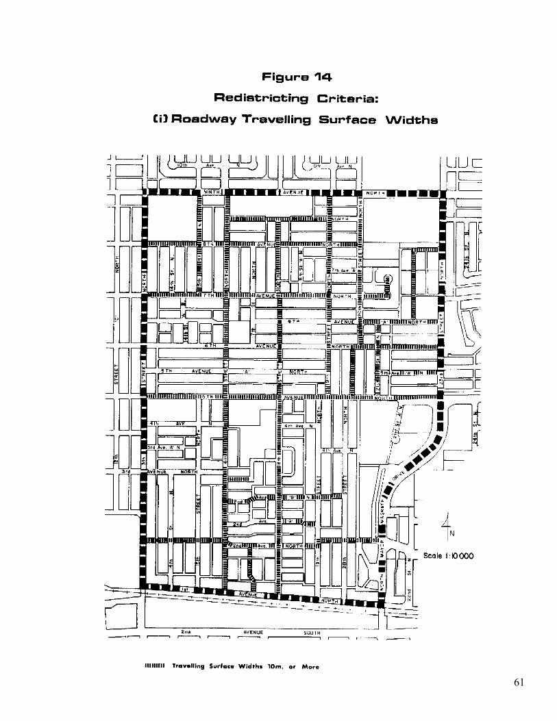
A set of redistricting criteria will be used to direct medium density development to those areas where it can best be accommodated without significantly detracting from the low density character of the neighbourhood. While no areas will be redistricted at this time, these criteria will be used to evaluate redistricting applications. Those residential parcels approved for redistricting in the Westminster Neighbourhood shall be subject to the regulations of the R-37 (medium density) district.
The first criterion is based on City policy for roadway travelling surface widths, while the second criterion allows for consideration of a site if it is in a transitional area. The third is based on the condition of buildings in neighbourhood blocks. A site may be eligible for redistricting if it meets the roadway widths criterion, and either the transitional areas criterion or the building conditions criterion. If a site’s eligibility is confirmed, redistricting may be approved at the discretion of City Council.
Criteria
1. Roadway Travelling Surface Widths
Redistricting shall not be permitted for any property fronting any road with a travelling surface of less than the current City standard of 10 metres (33 feet). Further, redistricting shall not be permitted on any section of a block isolated by streets and lanes, unless the abutting roadway has a surfaced width in excess of 10 metres for its entire length between intersecting roadways or is a 10 metre wide cul-de-sac with appropriate turning radius. All roadways satisfying this criterion are shown on Figure 14.
Medium density developments are not considered appropriate on roads with a travelling surface less than the current local road standard, particularly in a neighbourhood where on-street parking is common practice. On street parking on both sides of the street effectively limits traffic flow to one direction if there is less than a 10 metre paved surface.
59
61
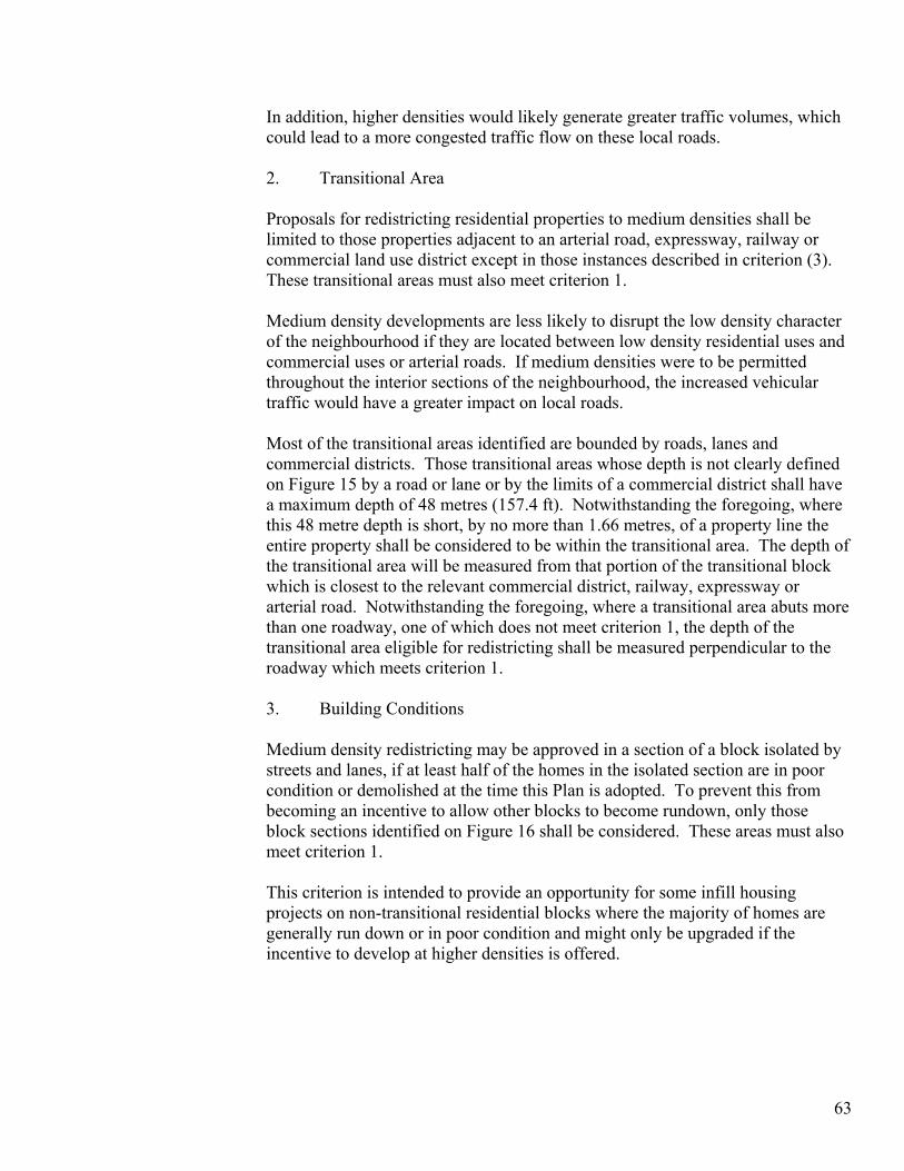
In addition, higher densities would likely generate greater traffic volumes, which could lead to a more congested traffic flow on these local roads. 2. Transitional Area Proposals for redistricting residential properties to medium densities shall be limited to those properties adjacent to an arterial road, expressway, railway or commercial land use district except in those instances described in criterion (3). These transitional areas must also meet criterion 1. Medium density developments are less likely to disrupt the low density character of the neighbourhood if they are located between low density residential uses and commercial uses or arterial roads. If medium densities were to be permitted throughout the interior sections of the neighbourhood, the increased vehicular traffic would have a greater impact on local roads. Most of the transitional areas identified are bounded by roads, lanes and commercial districts. Those transitional areas whose depth is not clearly defined on Figure 15 by a road or lane or by the limits of a commercial district shall have a maximum depth of 48 metres (157.4 ft). Notwithstanding the foregoing, where this 48 metre depth is short, by no more than 1.66 metres, of a property line the entire property shall be considered to be within the transitional area. The depth of the transitional area will be measured from that portion of the transitional block which is closest to the relevant commercial district, railway, expressway or arterial road. Notwithstanding the foregoing, where a transitional area abuts more than one roadway, one of which does not meet criterion 1, the depth of the transitional area eligible for redistricting shall be measured perpendicular to the roadway which meets criterion 1. 3. Building Conditions Medium density redistricting may be approved in a section of a block isolated by streets and lanes, if at least half of the homes in the isolated section are in poor condition or demolished at the time this Plan is adopted. To prevent this from becoming an incentive to allow other blocks to become rundown, only those block sections identified on Figure 16 shall be considered. These areas must also meet criterion 1. This criterion is intended to provide an opportunity for some infill housing projects on non-transitional residential blocks where the majority of homes are generally run down or in poor condition and might only be upgraded if the incentive to develop at higher densities is offered.
63
65

67
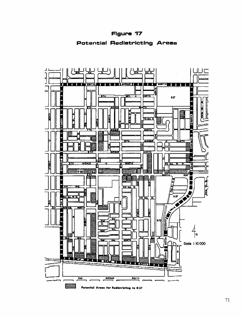
Potential Residential Redistricting Area The redistricting criteria described above have been proposed as a means of directing pressure for redevelopment to those areas in the neighbourhood where it can best be accommodated and of eliminating uncertainty as to where medium density housing may be developed. Following a public hearing on this Plan, City Council resolved that the properties on 14 Street North, between 7 and 8 Avenue North and on 16 Street North, between 7 and 8 Avenue North would not be considered eligible for redistricting. Figure 17, shows the potential redistricting areas. When the depth of potential redistricting areas is not clearly defined on Figure 17 by a road or lane or by the limits of a commercial district, these areas shall have a maximum depth of 48 metres (157.4 ft) as determined by the transitional areas criterion. All those parcels eligible for redistricting will be subject to the regulations of the R-37 district of the Land Use By-law if redistricting is approved. Where a site has been redistricted to R-37, vehicular access to any new development shall be provided from a roadway which is at least 10 metres wide or from a lane that connects to a roadway at least 10 metres wide. Since no direct access to 5th Avenue North will be allowed, this requirement may be waived for potential R-37 sites fronting 5th Avenue North if no lane access is available.
3.1.2 Special Considerations for New Residential Development on 1stAvenue North
The C.M.H.C. booklet, “Road and Rail Noise: Effects on Housing”, included a cautionary note, cited below, which is relevant to redevelopment along 1st Avenue North. “Caution should be exercised when building within 100 metres of a railway line. At this distance there is a possibility of high vibration and airborne noise. In such situation it is recommended that heavyweight construction be used and that a qualified person be consulted on other forms of vibration control which may be necessary.” In addition, noise levels generated both by the Crowsnest Trail and the railway may exceed the City’s standard for maximum acceptable noise levels which is 60 dB(A). For this reason, developers may wish to consider providing most of a multi-unit dwelling’s outdoor amenity space behind the building. The building will help to shield users from the noise generated by these two sources.
69
71
3.1.3 Low Density (R-L District)
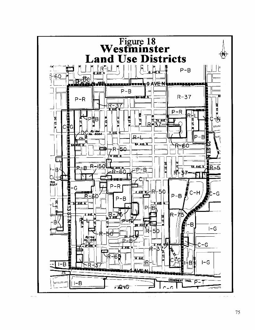
Except as noted below, in areas indicated as R-L on Figure 18 (Land Use Districts), all provisions of the R-L District of Land Use By-Law No. 4100 shall apply.
Narrow Lot Development or Subdivision
1. Purpose: The purpose of these provisions is to allow for renovation, alteration, development or redevelopment on existing lots that are less than 11 m wide, provided the renovations, alteration, or new development has been designed and is suitable for a narrow lot. These provisions are either in addition to, or in place of, provisions in the Land use By-law, as the case may be. 2. Permitted uses on narrow lots: none 3. Discretionary uses on narrow lots
a) Single detached dwelling b) Zero lot line dwelling* c) Accessory residential buildings d) All discretionary uses in the R-L district of the Land Use By-law e) Renovations or alterations
4. Minimum lot size:
Width 7.6m/dwelling unit Area 232.4m²/dwelling unit
5. Maximum floor area ratio, inclusive of all accessory building: 0.7 6. Minimum front, side and rear yard dimensions: the depth of all front, side and rear yards shall have regard to adjoining properties and the design of the dwelling, and shall be subject to the approval of the Municipal Planning Commission. 7. Zero lot line development:* may be considered when two or more contiguous lots in the same block frontage are to be developed. Such development shall be designed and sited with regard to the location, height, mass and condition of buildings in the vicinity. 8. Replotting and re-subdivision: all replotting schemes/re-subdivisions of areas intended for complete redevelopment (i.e. new dwellings) that are larger than the minimum requirements for two parcels in the standard R-L district (i.e. area: 640 m²; width: 22m; length: 30.0m) must result in the creation of lots which comply with the minimum parcel dimension and area requirements of the R-L district of the Land Use By-law.
73
* “zero lot line” dwelling and/or development means a single detached dwelling constructed on one of the side lot lines. Although there is no side yard setback on one side of the dwelling, the neighbouring property will have a sufficient side yard setback in order to ensure a 2.44 m separation between dwellings. Generally, zero lot line development will occur on a multiple-lot basis. On a lot where a zero lot line dwelling is permitted, accessory buildings may also be constructed on the same side lot line.
75
3.1.4 Property Maintenance and Rehabilitation
Due consideration shall be given to the policies and objectives of this Plan when enforcing the City’s Minimum Property Standards By-law in the Westminster Neighbourhood. Application of the By-law can help ensure that residential buildings are maintained in a reasonable condition, so as not to detrimentally affect neighbouring property values and to maintain an attractive residential area. Maintenance of existing housing stock is expected to lower pressure for redevelopment to higher densities.
Financial assistance for residential building maintenance and rehabilitation may be obtained through a number of government programs. These programs include the Residential Rehabilitation Assistance Program (R.R.A.P.), the Canadian Home Renovation Plan (C.H.R.P.), the Seniors’ Home Improvement Program and the Canadian Home Insulation Program (C.H.I.P)
3.2 COMMERCIAL LAND USE
3.2.1 Continued Commercial Activity
To ensure that commercial activities continue to be permitted on existing commercial sites, the commercial areas in the neighbourhood should continue to be districted for commercial uses.
3.2.2 Limited Commercial Expansion
Besides ensuring that commercial areas remain commercial, it is equally important that commercial expansion be on a very limited basis. As noted in Policy 5.2, if expansion of the Westminster Mall is proposed, redistricting the remaining residential parcel on this block to a C-G designation may be appropriate. This expansion would not be large and would be contained within a block, which is already predominantly commercial. To ensure expansion does not increase traffic volumes on 4th Avenue North, vehicular access to the Mall’s parking areas should be limited to existing access points.
3.2.3 Commercial Parking Requirements1
All new commercial buildings in the Westminster Neighourhood shall meet the parking requirements as set out in Land Use Bylaw 4100. To ensure there are no parking shortages in the neighbourhood’s commercial areas, waivers will not be granted for new commercial buildings or additions to existing buildings. By
771 Bylaw 5065, November 27,2000
providing the number of parking stalls required in the Land Use By-law, parking shortages will be avoided and commercial-related parking can be contained within the commercial areas. Waivers should, when considered appropriate by the Municipal Planning Commission, be granted as required to new uses in existing buildings. It may be unrealistic to expect existing development to provide sufficient parking for all new uses when the space was not previously available or required by development approvals.
3.3 OPEN SPACE
All P-R designated sites in the Westminster Neighbourhood shall be governed by the relevant provisions of the Land Use By-law.
3.3.1 Accessibility to Open Space
The area south of 2nd Avenue North and a smaller area between 5th Avenue North and 5th Avenue “A” North, west of 19th Street North, require improved access to open space for young children because access to the closest playground crosses a major road. Policy 4.1 directs the City to meet this need by ensuring suitable access is provided across collectors and arterials to existing open space areas or by attempting to purchase additional land for play lots (tot lots). Consideration could be given to providing signalized crosswalks across 2nd Avenue North to improve access to existing open space. It is recommended that any changes proposed to the design and/or function of 5th Avenue North that may affect existing crosswalks across this roadway be referred to Community Services and the Planning Department. If play lots are developed, the first should be developed south of 2nd Avenue North since it is a larger area. The design of play lots will be determined by the City, in consultation with the Westminster Neighbourhood Association and the affected residents. However, each play lot should contain traditional or creative play equipment and an open play area.
78
3.4 TRANSPORTATION
3.4.1 Public Transit
Any transit route changes made in the Westminster Neighbourhood should maintain the current standard of providing bus service within 400 metres walking distance of all parts of the neighbourhood. Whenever practical, two-way service should be provided. Development of senior citizens’ housing should only be approved on sites that lie within 200 metres of a two-way bus route.
3.4.2 Bicycle Routes
Policy 7.4 affirms the City’s support of a bicycle route system in the Westminster Neighbourhood as proposed in the Bicycle Routes report, approved in principle in April, 1980. Initially, the City should consider improvements on existing routes to ensure safer and more convenient bicycle travel. Before any commitment to expenditures is made, however, Engineering, Community Services and the Planning Department should review the physical changes required to improve the bicycle transportation system in the Westminster Neighbourhood. This review should examine the need for more signalized pedestrian crosswalks at strategic locations across major roads, particularly 2nd Avenue North. The review should also determine those routes requiring separate bicycle rights-of-way.
3.4.3 2nd Avenue North
If monitoring along 2nd Avenue North shows traffic volumes are increasing beyond normal collector road volumes, measures that should be considered to provide safe pedestrian access across this route include reducing the speed limit, and providing signalized pedestrian crossings. To permit safer traffic flow on this roadway it may also be necessary to provide a wider two lane travelling surface either by prohibiting on-street parking or by widening the paved surface.
3.4.4 5th Avenue North Since 5th Avenue North is an east-west arterial and could be widened to four lanes, access to future residential development fronting 5th Avenue North will be permitted only from rear lanes and local streets.
79
4.0 LAND USE BY-LAW RELATIONSHIP
4.1 CONCURRENT AMENDMENTS
Except as set out in Section 4.2 below, the requirements of Land Use By-law 4100 shall apply in the Westminster Neighbourhood, as for the respective districts as shown on Figure 18 (Westminster Land Use Districts Map). Section 3.1.1 of this Plan defines certain cases in which the provisions of the R-37 district may appropriately replace the requirements of the R-L district. Concurrent amendments shall be made to the Land Use By-law and Figure 18 of this Plan to implement any such changes.
4.2 STATUTORY PLAN OVERLAY
The Land use Districts Map of Land Use By-law 4100 identifies the area governed by this Area Redevelopment Plan. The objectives, policies and implementation section of the Westminster Neighbourhood Area Redevelopment Plan shall apply and be complied with when interpreting and applying land use planning and development controls in the Westminster Neighbourhood.
4.3 RELATIONSHIP OF THE NEW LAND USE BY-LAW TO THE WESTMINSTER NEIGHBOURHOOD AREA REDEVELOPMENT PLAN.
When this Plan was adopted on February 11, 1985, Land Use By-law No. 3574 was in effect. Land Use By-law No. 3574 was repealed and replaced by a new by-law, namely Land Use By-law 4100. The policies of this Plan have been altered only to reflect the terminology and land use districts found in the new Land Use By-law. The background material is unchanged since it consists of the information relevant at the time the policies were originally adopted, and should be read in that context. Under the zoning of Land Use By-law No. 3574, some residential development exceeded the minimum densities allowed but was recognized as conforming to Land Use By-law No. 3574 if the development had been approved under the City’s old Zoning By-law. To ensure these uses conform with the new Land Use By-law, they have been assigned a land use district that allows the density at which these buildings were developed. No increase in densities or gross floor areas of these buildings beyond that which existed at the time of adoption of this Plan shall be permitted.
81