Wdr2010 Graphics Ch2
12
Figures and Maps: Chapter 2 Reducing Human Vulnerability: Helping People Help Themselves Rights and Permissions The material in this publication is copyrighted. Copying and/or transmitting portions or all of this work without permission may be a violation of applicable law. The International Bank for Reconstruction and Development / The World Bank encourages dissemination of its work and will normally grant permission to reproduce portions of the work promptly. For permission to photocopy or reprint any part of this work, please send a request with complete information to the Copyright Clearance Center Inc., 222 Rosewood Drive, Danvers, MA 01923, USA; telephone: 978-750- 8400; fax: 978-750-4470; Internet: www.copyright.com . All other queries on rights and licenses, including subsidiary rights, should be addressed to the Office of the Publisher, The World Bank, 1818 H Street NW, Washington, DC 20433, USA; fax: 202-522-2422; e-mail: [email protected].
-
Upload
wringobanker -
Category
Documents
-
view
273 -
download
3
Transcript of Wdr2010 Graphics Ch2

Figures and Maps: Chapter 2Reducing Human Vulnerability: Helping People Help Themselves
Rights and Permissions
The material in this publication is copyrighted. Copying and/or transmitting portions or all of this work
without permission may be a violation of applicable law. The International Bank for Reconstruction and
Development / The World Bank encourages dissemination of its work and will normally grant permission to
reproduce portions of the work promptly.
For permission to photocopy or reprint any part of this work, please send a request with complete information
to the Copyright Clearance Center Inc., 222 Rosewood Drive, Danvers, MA 01923, USA; telephone: 978-750-
8400; fax: 978-750-4470; Internet: www.copyright.com.
All other queries on rights and licenses, including subsidiary rights, should be addressed to the Office of the
Publisher, The World Bank, 1818 H Street NW, Washington, DC 20433, USA; fax: 202-522-2422; e-mail:

F2.1 The number of people affected by climate-related disasters is increasing
Sources: WDR team; CRED 2009.
Note: Over the past 40 years the death toll has fallen but the number of people affected has doubled every decade. (People affected are those requiring immediate assistance during a period of emergency and can also include displaced or evacuated people.) In lower-middle-income countries almost 8 percent of the population is affected each year. The increase cannot be attributed only to climate change; much results from population increase, greater exposure of infrastructure and improved reporting of disasters. However, the impacts on people are just as real and show why it is so essential to begin focusing on the current adaptation deficit while looking ahead to a more climatically stressful future.
World Development Report 2010

F2.2 Floods are increasing, even in drought-prone Africa
World Development Report 2010
Source: WDR team analysis from CRED 2009.
Note: Flood events are increasing everywhere but particularly in Africa, with new regions being exposed to flooding and with less recovery time between events. Reporting of events may have improved since the 1970s, but this is not the main cause of rising numbers of reported floods, because the frequency of other disaster events in Africa, such as droughts and earthquakes, has not shown a similar increase.

F2.3 Insurance is limited in the developing world
World Development Report 2010
Source: Swiss Re 2007.
Note: Insurance is primarily a developed-country market as indicated by the regional share of premiums (left), and penetration (premium as percent of GDP) of non–life insurance (right). Non–life insurance includes property, casualty, and liability insurance (also referred to as general insurance), health insurance, and insurance products not defined as life insurance.

F2.4 Turning back the desert with indigenous knowledge, farmer action, and social learning
World Development Report 2010
Sources: WRI and others 2008; Botoni and Reij 2009; Herrmann, Anyamba, and Tucker 2005.
Note: In Niger farmers have turned back the encroaching desert; landscapes that were denuded in the 1980s are now densely studded with trees, shrubs, and crops. This transformation, so vast that its effects can be observed from satellites, has affected 5 million hectares of land (about the size of Costa Rica), which amounts to almost half of the cultivated land in Niger. The new economic opportunities created by the regreening have benefited millions of people through increased food security and resilience to drought. Key to this success was a low-cost technique known as farmer-managed natural regeneration that adapts a centuries-old technique of woodland management. After some earlier success with the reintroduction of this indigenous technique in the 1980s, farmers saw the benefits and spread the word. The social learning effect was enhanced by donors supporting farmer study tours and farmer-to-farmer exchanges. The central government’s role was pivotal in reforming land tenure and forest policies.

M2.1 At risk: Population and megacities concentrate in low-elevation coastal zones threatened by sea level rise and storm surges
World Development Report 2010
Source: United Nations 2008a.
Note: Megacities in 2007 included Beijing, Bombay, Buenos Aires, Cairo, Calcutta, Dhaka, Istanbul, Karachi, Los Angeles, Manila, Mexico City, Moscow, New Delhi, New York, Osaka, Rio de Janeiro, São Paulo, Seoul, Shanghai, and Tokyo. Megacities are defined as urban areas with more than 10 million inhabitants.

M2.2 A complex challenge: managing urban growth and flood risk in a changing climatein South and Southeast Asia
Sources: WDR team; CRED 2009.
Note: Over the past 40 years the death toll has fallen but the number of people affected has doubled every decade. (People affected are those requiring immediate assistance during a period of emergency and can also include displaced or evacuated people.) In lower-middle-income countries almost 8 percent of the population is affected each year. The increase cannot be attributed only to climate change; much results from population increase, greater exposure of infrastructure and improved reporting of disasters. However, the impacts on people are just as real and show why it is so essential to begin focusing on the current adaptation deficit while looking ahead to a more climatically stressful future.
World Development Report 2010

M2.3 Northern cities need to prepare for Mediterranean climate—now
World Development Report 2010
Source: WDR team, reproduced from Kopf, Ha-Duong, and Hallegatte 2008.
Note: With increasing global temperatures, climate zones will shift north, and by the middle of the 21st century many central and northern European cities will “feel” Mediterranean. This is not good news and has major implications: water utilities will need to adjust management plans, and health services will need to be prepared for more extreme heat episodes (similar to the 2003 European heat wave). While a few degrees of warming may seem appealing on a cold winter day in Oslo (the scenario shown in the map corresponds approximately to a global temperature increase of 1.2°C relative to today), the necessary changes in planning, public health management, and urban infrastructure are substantial. Buildings that were designed and engineered for cold harsh winters will need to function in a drier and hotter climate, and heritage buildings may suffer irreparable damages. Even more challenging is the construction of new buildings today as their design needs to be highly flexible to gradually adjust to drastically different conditions over the coming decades.

M2.4 Climate change accelerates the comeback of dengue in the Americas
World Development Report 2010
Source: PAHO 2009.
Note: Infectious and vector-borne diseases have been expanding into new geographic areas all over the world. In the Americas the incidence of dengue fever has been rising because of increasing population density and widespread international travel and trade. Changes in humidity and temperature brought about by climate change amplify this threat and allows disease vectors (mosquitoes) to thrive in locations previously unsuitable for the disease; see Knowlton, Solomon, and Rotkin-Ellman 2009.
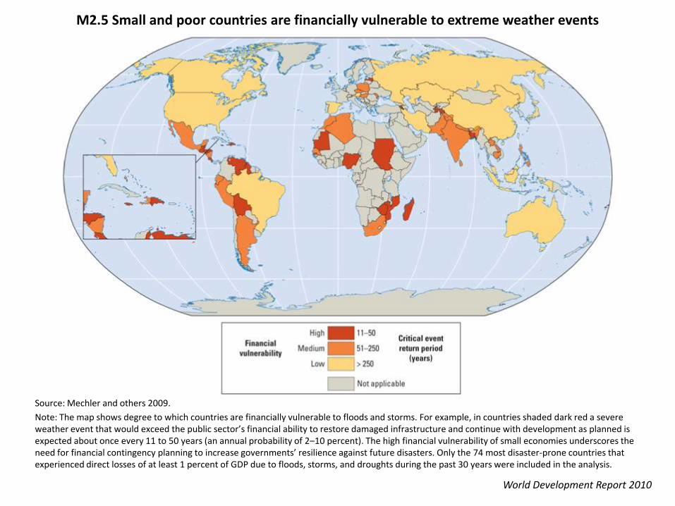
M2.5 Small and poor countries are financially vulnerable to extreme weather events
World Development Report 2010
Source: Mechler and others 2009.
Note: The map shows degree to which countries are financially vulnerable to floods and storms. For example, in countries shaded dark red a severe weather event that would exceed the public sector’s financial ability to restore damaged infrastructure and continue with development as planned is expected about once every 11 to 50 years (an annual probability of 2–10 percent). The high financial vulnerability of small economies underscores the need for financial contingency planning to increase governments’ resilience against future disasters. Only the 74 most disaster-prone countries that experienced direct losses of at least 1 percent of GDP due to floods, storms, and droughts during the past 30 years were included in the analysis.

M2.6 Senegalese migrants settle in flood-prone areas around urban Dakar
World Development Report 2010
Source: Geoville Group 2009.
Note: Slow economic growth in the agricultural sector has made Dakar the destination of an exodus from the rest of the country. Forty percent of Dakar’s new inhabitants between 1988 and 2008 have moved into zones of high flood potential, twice as high as that of Dakar’s urban (19 percent) and rural communes (23 percent). Because urban expansion is geographically limited, the influx of migrants has resulted in a very high concentration ofpeople in urban and peri-urban zones (in the map, 16 pixels constitute one square kilometer).

BoxF2.12 Migration today
World Development Report 2010
Sources: Parsons and others 2007; IDMC 2008
![Wdr2010 Graphics Ch0 Overview[1]](https://static.fdocuments.in/doc/165x107/55a1f8821a28ab826d8b468c/wdr2010-graphics-ch0-overview1.jpg)


![blog. · Web viewANSWER: B ANSWER: C [CI`(H2O)4C1(NO2)]CI COON HOOC-CH2\N_CCH~_CH___N/H Ml ` | ` \' ' CH2 CH2 -COOH HOOC' HOOC`.."CHZ CH2"COOH \ I /N-CH2-CH2-N\ HOOC""CH2 CH2-COOH](https://static.fdocuments.in/doc/165x107/5ab561c67f8b9a0f058cbd1a/blog-viewanswer-b-answer-c-cih2o4c1no2ci-coon-hooc-ch2ncchchnh.jpg)
![Synthesis of Novel Electrically Conducting Polymers: Potential ... · PPh3 + Br(CH2). CO2Me ..... > [Ph3P--CH2(CH2). i CO2Me]*Br* [phaP--CH2(CH2)n__CO2Mel*Br -Z--BuL>_phaP=CH (C H2)n_i](https://static.fdocuments.in/doc/165x107/5ebc39ab077be8135d1c1d2a/synthesis-of-novel-electrically-conducting-polymers-potential-pph3-brch2.jpg)