Water resource evaluation and management for Morar River Basin
12
e-Journal Earth Science India Vol.2 (III), July, 2009, pp. 174 - 186 http://www.earthscienceindia.info/ ; ISSN: 0974 - 8350 1 Water resource evaluation and management for Morar River Basin, Gwalior district, Madhya Pradesh, Using GIS P.K.Singh 1 and U.C.Singh 2 1 Center for Remote Sensing and GIS, Maulana Azad National Institute of Technology, Bhopal -462007 (M.P) 2 Schools of Studies in Earth Science, Jiwaji University, Gwalior-474011, (M.P) Email: [email protected]; [email protected] Abstract Assessment of groundwater prospects has been carried out for the Morar river basin in Gwalior district, Madhya Pradesh. Groundwater prospect of the basin has been delineated from the satellite data by the integration of geology, geomorphology, lineament and slope and classified as Excellent to poor groundwater potential zones using GIS. The results obtained from remotely sensed data cross checked with the bore well yield data and found in good agreement. This depicts the positive prospective zones in the study area for exploration of groundwater in future. Water level fluctuation map prepared from the pre- and post-monsoon water level data do not show any significant change except at some locations in alluvial area Net groundwater availability also calculated is about 63.634 MCM. The calculated annual draft of Groundwater from dug wells and tube wells for all users is 70.051 MCM revealing a deficit in groundwater storage in the Basin. Introduction Rapid industrial development, urbanization and increase in agricultural production have led to freshwater shortages in many parts of the world. In view of increasing demands of water for various purposes like agricultural, domestic and industrial, a greater emphasis is being laid for a planned and optimal utilization of water resources. On other hand, continuous withdrawals from a groundwater reservoir in excess of replenishable recharge may result in lowering of water table. There is an uregent need of planned and optimal development of water resources. An appropriate strategy is required to develop water resources with planning based on conjunctive use of surface and subsurface water resources. In recent time many workers such as Raghuvansi et al., 2008; Prasad et al., 2008; Rokade et al., 2007; Jha et al., 2007 ; Leblanc et al., 2007; Saraf et al., 2004 and Teeuw,1995 used GIS for evaluation and management of groundwater resources of the various terrains. One of the greatest advantages of using remote sensing data for groundwater investigation and monitoring is its ability to generate information in spatial and temporal domain, which is very crucial for successful analysis, prediction and validation (Jaiswal et al., 2003; Murthy, 2000; Saraf and Choudhuray, 1998; Krishnamurthy et al., 1996). The Morar River, a tributary of the Vaisali River, flows northerly in the study area. Agriculture is the main source of livelyhood of the people living in rural area which gets irrigation mainly through surface water and groundwater (through tubewells). The development of groundwater resource in the study area is quite poor. Results of
Transcript of Water resource evaluation and management for Morar River Basin
e-Journal Earth Science India Vol.2 (III), July, 2009, pp. 174 - 186
http://www.earthscienceindia.info/ ; ISSN: 0974 - 8350
1
Water resource evaluation and management for
Morar River Basin, Gwalior district,
Madhya Pradesh, Using GIS
P.K.Singh 1 and U.C.Singh2
1 Center for Remote Sensing and GIS,
Maulana Azad National Institute of Technology, Bhopal -462007 (M.P) 2 Schools of Studies in Earth Science, Jiwaji University, Gwalior-474011, (M.P)
Email: [email protected]; [email protected]
Abstract
Assessment of groundwater prospects has been carried out for the Morar river
basin in Gwalior district, Madhya Pradesh. Groundwater prospect of the basin has been
delineated from the satellite data by the integration of geology, geomorphology,
lineament and slope and classified as Excellent to poor groundwater potential zones
using GIS. The results obtained from remotely sensed data cross checked with the bore
well yield data and found in good agreement. This depicts the positive prospective zones
in the study area for exploration of groundwater in future.
Water level fluctuation map prepared from the pre- and post-monsoon water
level data do not show any significant change except at some locations in alluvial area
Net groundwater availability also calculated is about 63.634 MCM. The calculated annual
draft of Groundwater from dug wells and tube wells for all users is 70.051 MCM revealing a deficit in groundwater storage in the Basin.
Introduction
Rapid industrial development, urbanization and increase in agricultural production
have led to freshwater shortages in many parts of the world. In view of increasing demands
of water for various purposes like agricultural, domestic and industrial, a greater emphasis
is being laid for a planned and optimal utilization of water resources. On other hand,
continuous withdrawals from a groundwater reservoir in excess of replenishable recharge
may result in lowering of water table. There is an uregent need of planned and optimal
development of water resources. An appropriate strategy is required to develop water
resources with planning based on conjunctive use of surface and subsurface water
resources.
In recent time many workers such as Raghuvansi et al., 2008; Prasad et al., 2008;
Rokade et al., 2007; Jha et al., 2007 ; Leblanc et al., 2007; Saraf et al., 2004 and
Teeuw,1995 used GIS for evaluation and management of groundwater resources of the
various terrains. One of the greatest advantages of using remote sensing data for
groundwater investigation and monitoring is its ability to generate information in spatial and
temporal domain, which is very crucial for successful analysis, prediction and validation
(Jaiswal et al., 2003; Murthy, 2000; Saraf and Choudhuray, 1998; Krishnamurthy et al.,
1996).
The Morar River, a tributary of the Vaisali River, flows northerly in the study area.
Agriculture is the main source of livelyhood of the people living in rural area which gets
irrigation mainly through surface water and groundwater (through tubewells). The
development of groundwater resource in the study area is quite poor. Results of

Water resource evaluation and management for Morar River Basin, Gwalior district, Madhya Pradesh, Using GIS: P.K.Singh and U.C.Singh
groundwater explorations indicate that there is enough scope for groundwater development
through suitable abstraction structures. In order to maximize agricultural production and
overall improvement of socio-economic conditions of the people, there is a need for optimal
utilization of groundwater resource of the study area. In view of these objectives, available
hydrogeological data generated / procured from all sources during the present study have
been compiled and assessment of groundwater resource of the area has been attempted.
Data Used and Methodology
In the present study IRS –IC LISS III and PAN data were used and they are
geometrically rectified and registered with SOI toposheet maps on 1:50,000 scale using
ERDAS IMAGINE 8.7 image processing software. Various thematic layers viz. geology,
geomorphology, lineament were generated on the basis of their image characteristic and by
applying digital image processing techniques. Geographical Information System (ARC GIS
9.0) has been used for digitization, editing and topology creation. Spatial Analysis tool of
ARC GIS software used for Integration of thematic layers and delineation of groundwater
potential zones. The details of data used in present study shown in (Table-1).
Well inventory has been carried out for the generation of water level fluctuation map
within the basin. Water balance estimation techniques have been extensively used to make
quantitative estimates of ground water resources within the basin.
Table-1: Details of the data used in Present Study
General features of the study area
The Morar River Basin lying between the latitudes 260 5’ -260 25’ N and longitudes
78010’-780 25’ E and covering an area around 405 sq. km. in Gwalior district of Madhya
Pradesh has been selected for the present study (Fig.1).
The area experiences a semi-arid climate marked by extreme temperature and
variable of rainfall. It can be noticed from the annual rainfall data that the pattern of rainfall
is erratic. Maximum rainfall of 1128 mm. was during 1982 and minimum of 443mm. in the
year 2006. The rainfall generally increases from north to south.
Type of Data Details Source
IRS – ID LISS III and
PAN Digital data
Path / Row : 97 /53 National Remote
Sensing Agency
(NRSA), Hyderabad
Survey of India
(SOI)Toposheets,
54 J/3 , J/, J/7 and J/8 Survey of India,
Dehradun
Geological Quadrangle
Map
Scale : 1,250,000 Geological Survey of
India , Hyderabad
Yield Data / Well
Inventory data
Water Level Data Field Survey

e-Journal Earth Science India Vol.2 (III), July, 2009, pp. 174 - 186
http://www.earthscienceindia.info/ ; ISSN: 0974 - 8350
3
Fig. 1: Location map of study area
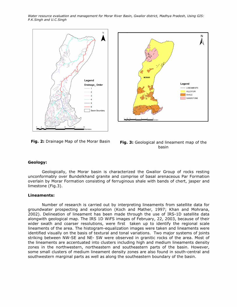
Drainage:
The drainage pattern of the basin has provided quantitative description of basin
geometry, which helps to understand initial slope of inequality in rock hardness. The basin is
characterized by dendritic type of drainage pattern with varying density (Fig. 2). The high
density found on the hard sandstone and shales. The total length of the basin is 479 km.
and perimeter of the basin is 121.27 km. The Morar river basin is a 6th order basin with a
drainage area of 405 sq. km (Table-2). The morphometric analysis carried out has revealed
that the drainage density of the basin is 1. 18 km. this suggests that the area has highly
permeable soil.
Table-2: Morphometric analysis of Morar river basin
Morar
River
Basin
Strea
m
Order
(w)
No. of
Stream
s
(Nu)
Bifurcatio
n
Ratio
(Rb)
Bifurcatio
n ratio
mean
Total
length
of
stream
s in km
Mean
length
of the
Stream
s
in km.
Draina
ge
Densit
y
I 501 303.49
II 206 2.43 89
III 42 4.90 3.72 29.06 0.628 1.18
IV 11 3.81 8.88
V 2 5.5 9.41
VI 1 2 39.50
Water resource evaluation and management for Morar River Basin, Gwalior district, Madhya Pradesh, Using GIS: P.K.Singh and U.C.Singh
Fig. 2: Drainage Map of the Morar Basin
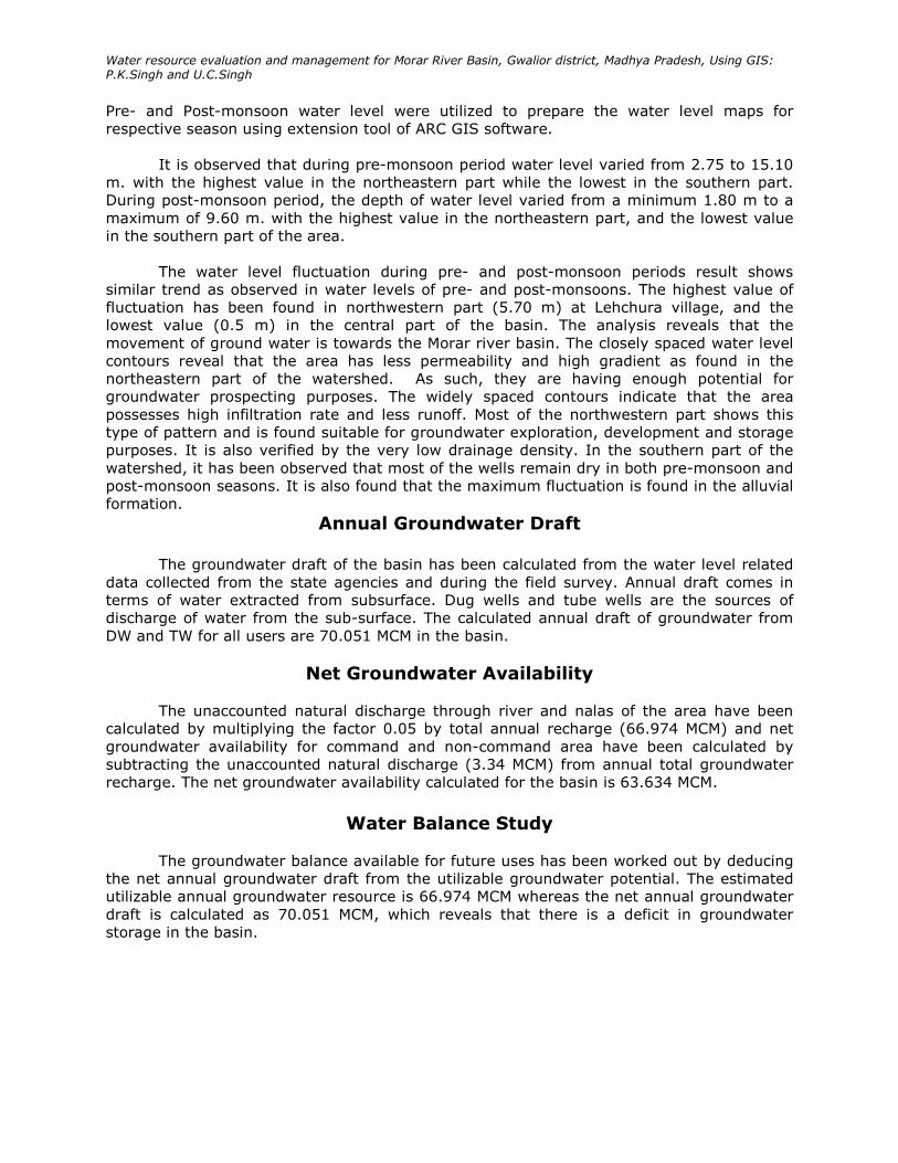
Fig. 3: Geological and lineament map of the
basin
Geology:
Geologically, the Morar basin is characterized the Gwalior Group of rocks resting
unconformably over Bundelkhand granite and comprise of basal arenaceous Par Formation
overlain by Morar Formation consisting of ferruginous shale with bands of chert, jasper and
limestone (Fig.3).
Lineaments:
Number of research is carried out by interpreting lineaments from satellite data for
groundwater prospecting and exploration (Koch and Mather, 1997; Khan and Mohrana,
2002). Delineation of lineament has been made through the use of IRS-1D satellite data
alongwith geological map. The IRS 1D WiFS images of February, 22, 2003, because of their
wider swath and coarser resolutions, were first taken up to identify the regional scale
lineaments of the area. The histogram-equalization images were taken and lineaments were
identified visually on the basis of textural and tonal variations. Two major systems of joints
striking between NW-SE and NE- SW were observed in granitic rocks of the area. Most of
the lineaments are accentuated into clusters including high and medium lineaments density
zones in the northwestern, northeastern and southeastern parts of the basin. However,
some small clusters of medium lineament density zones are also found in south-central and
southwestern marginal parts as well as along the southeastern boundary of the basin.

e-Journal Earth Science India Vol.2 (III), July, 2009, pp. 174 - 186
http://www.earthscienceindia.info/ ; ISSN: 0974 - 8350
5
Geomorphology and Slope:
On the basis of interpretation of satellite image, various hydrogeomorphological
features within the basin have been identified. On the basis of lithology, topography and
drainage, It is found that the study area comprises of different hydrogeomorphic units such
as alluvial plain, valley fills, pediplains, buried pedipain, pedimonts and residual hills (Fig.
4).
Slope map was prepared from SRTM data. Most of the area have flat topography,
accept the southern part, which is as hilly terrain having steep slope. Finally slope map was
prepared using ARC GIS software and the entire area is classified into four groups as very
gentle slope (00 – 30), gentle slope (30 – 100), moderately steep (100 – 200) and very steep
(> 250). A high slopeing region causes more runoff and less infiltration and thus has poor
groundwater prospects compared to the low slope region (Fig. 5).
Fig. 4: Geomorphological map of the Basin
Fig. 5: Slope Map of the Basin

Water resource evaluation and management for Morar River Basin, Gwalior district, Madhya Pradesh, Using GIS: P.K.Singh and U.C.Singh
Groundwater Prospect Map
As discussed in earlier sections, each thematic map as geology, geomorphology,
lineaments and slope gives clue for the conditions of the occurrence of groundwater. In
order to obtain final groundwater potential picture of the area, it is essential to integrate
these layers in GIS. Each thematic map has weightage criteria depending on its strength of
influence / contribution towards the groundwater reserve (Table-3).
GIS integration is done taking two layers at a time and overlaying them to intersect
and thus a new layer is obtained. The new layer is integrated with next layer from the
remaining thematic maps. All the four layers were integrated in this manner. Once the
layers are integrated, all the weightage of intersected layers were summed up to get the
Groundwater Potential Zone of the area. Finally GWPZ map was prepared (Fig. 6) showing
poor to excellent groundwater potential zones of the area.
Table- 3: Characterization criteria of maps
Validity Test
In order to make the classification more realistic, the groundwater prospect map
(Fig. 6) was verified with yield data to check the validity of the study. The validity of the
work was checked against the bore well yield data which reflects the groundwater potential
are in agreement with the bore well yield data. Yield of drilled sites occurred in this model
have ranges from 2500 to 3500 lph in the excellent groundwater potential zone, 800 to 900
lph in good groundwater potential zone, 600 to 700 lph in moderate and 300 to 400 lph in
poor groundwater potential zones.
S.No. Thematic Map Basis of Characterization
1. Geology Rock type and their water holding
characteristics
2. Lineament Present / Absent
3. Geomorphology Type and their Aerial extent.
4. Slope Slope Percentage

e-Journal Earth Science India Vol.2 (III), July, 2009, pp. 174 - 186
http://www.earthscienceindia.info/ ; ISSN: 0974 - 8350
7
Fig. 6: Groundwater potential zones of the basin
Groundwater assessment
An appropriate strategy will be required to develop water resources with planning
based on conjunctive use of surface water resources and subsurface groundwater resources.
The development of groundwater resource in the study area is quite poor. Results of
groundwater explorations indicate that there is enough scope for groundwater development
through suitable abstraction structures. In order to maximize agricultural production and
overall improvement of socio-economic conditions of the people, there is a need for optimal
utilization of groundwater resource of the basin.
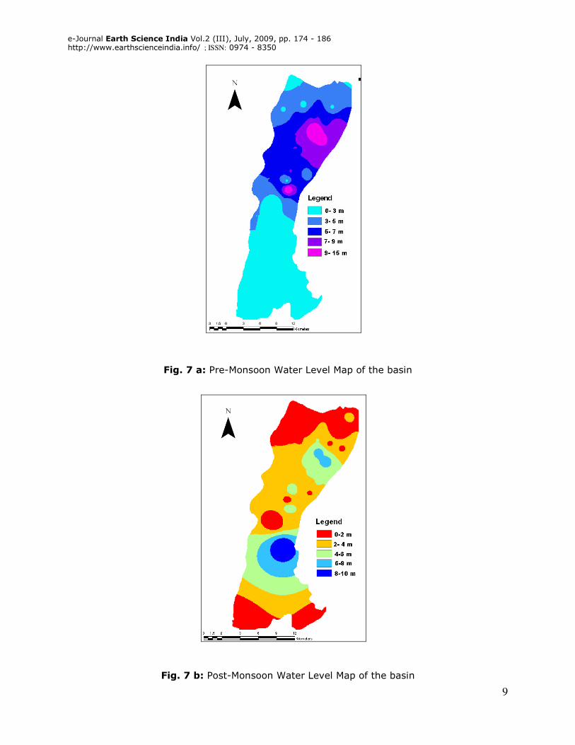
The Agricultural and domestic needs of groundwater in the study area are met
mainly from the monsoonal and non-monsoonal rainfall, which has significant contribution.
The data on the status of the water level has been analysed to understand the hydraulic
characteristics of the area .The depth to groundwater level maps were prepared from the
well inventory data obtained for both Pre-monsoon and Post-monsoon periods (Fig.7 a & b).
Water resource evaluation and management for Morar River Basin, Gwalior district, Madhya Pradesh, Using GIS: P.K.Singh and U.C.Singh
Pre- and Post-monsoon water level were utilized to prepare the water level maps for
respective season using extension tool of ARC GIS software.
It is observed that during pre-monsoon period water level varied from 2.75 to 15.10
m. with the highest value in the northeastern part while the lowest in the southern part.
During post-monsoon period, the depth of water level varied from a minimum 1.80 m to a
maximum of 9.60 m. with the highest value in the northeastern part, and the lowest value
in the southern part of the area.
The water level fluctuation during pre- and post-monsoon periods result shows
similar trend as observed in water levels of pre- and post-monsoons. The highest value of
fluctuation has been found in northwestern part (5.70 m) at Lehchura village, and the
lowest value (0.5 m) in the central part of the basin. The analysis reveals that the
movement of ground water is towards the Morar river basin. The closely spaced water level
contours reveal that the area has less permeability and high gradient as found in the
northeastern part of the watershed. As such, they are having enough potential for
groundwater prospecting purposes. The widely spaced contours indicate that the area
possesses high infiltration rate and less runoff. Most of the northwestern part shows this
type of pattern and is found suitable for groundwater exploration, development and storage
purposes. It is also verified by the very low drainage density. In the southern part of the
watershed, it has been observed that most of the wells remain dry in both pre-monsoon and
post-monsoon seasons. It is also found that the maximum fluctuation is found in the alluvial
formation.
Annual Groundwater Draft
The groundwater draft of the basin has been calculated from the water level related
data collected from the state agencies and during the field survey. Annual draft comes in
terms of water extracted from subsurface. Dug wells and tube wells are the sources of
discharge of water from the sub-surface. The calculated annual draft of groundwater from
DW and TW for all users are 70.051 MCM in the basin.
Net Groundwater Availability
The unaccounted natural discharge through river and nalas of the area have been
calculated by multiplying the factor 0.05 by total annual recharge (66.974 MCM) and net
groundwater availability for command and non-command area have been calculated by
subtracting the unaccounted natural discharge (3.34 MCM) from annual total groundwater
recharge. The net groundwater availability calculated for the basin is 63.634 MCM.
Water Balance Study
The groundwater balance available for future uses has been worked out by deducing
the net annual groundwater draft from the utilizable groundwater potential. The estimated
utilizable annual groundwater resource is 66.974 MCM whereas the net annual groundwater
draft is calculated as 70.051 MCM, which reveals that there is a deficit in groundwater
storage in the basin.
e-Journal Earth Science India Vol.2 (III), July, 2009, pp. 174 - 186
http://www.earthscienceindia.info/ ; ISSN: 0974 - 8350
9
Fig. 7 a: Pre-Monsoon Water Level Map of the basin
Fig. 7 b: Post-Monsoon Water Level Map of the basin
Water resource evaluation and management for Morar River Basin, Gwalior district, Madhya Pradesh, Using GIS: P.K.Singh and U.C.Singh
Groundwater Development and Management
The management of a groundwater basin implies a programme for development and
utilization of water resources for the benefit of Mankind. The groundwater appraisal for
economic development and planning of water resources of the Morar watershed has been
discussed which reveals that it requires appropriate assessment for the consumption.
In most low rain fall areas of the country, the availability of utilizable surface water is
so low that people have to depend largely on groundwater for agricultural and domestic uses.
Excessive groundwater pumping in the study area, especially in the urban area has resulted in
alarming lowering of groundwater levels. The problem has been further compounded due to
large – scale urbanization and growth of city, which has drastically reduced open lands for
natural recharge. In the study area, there area large variations in ground water availability
from place to place.
Geologically, the area is covered by alluvium, shale and sandstone. Among these
lithounits, alluvium is the main target of the area for groundwater exploration and storage
purposes. It covers most of the northern part of the Morar block with more or less plain area.
Shale is a potential lithounit in the area and because of clayey composition it has very low
infiltration capacity leading to higher rate of runoff. It also covers the southern as well as
central part of the area in the form of residual hills at topographic high. This clayey
composition of the shale of Morar Formation of the area is subjected to very irregular erosion
of the soil due to which it looses it productive capacity. During field survey it is found that in
some pockets there is excess runoff during rainy period. Sandstones are found in the form of
structural hills and they have some potential for groundwater storage.
The water supply in the area is done through the surface water supply system and
tube wells. Tighra reservoir is the main source of water for drinking purpose in the area
managed by Municipal Corporation in urban area and Panchayats in the rural area.
The exploration of groundwater for irrigation purpose has been increased gradually in
the recent years. Almost 46 % of the total area is irrigated by groundwater through tube
wells. The number of tube wells has increased drastically. Thus, the annual growth rate of
tube wells and dug wells have increased upto 54.5 % and 47 % respectively in the Morar
block.
The groundwater development is increasing every year. The number of water
harvesting structures and the area irrigated by groundwater has increased in the successive
years. The development of groundwater can be noticed by visualizing long term water level
trends as observed by decline trends in the non- command area.
The number of water harvesting structures is distributed dividing balance resources
equally for dug wells and tube wells and taking consideration of 100 % development of net
groundwater availability in the block. Therefore, it is suggested that a scientific study at every
five years period is a must to check the impact of groundwater development on groundwater
regime and accordingly number of structures should be modified. By considering these points,
there are many ways to adopt this practice but the structures which are feasible in the study
area are: contour bundings, gully plugs, check dams, percolation tank, recharge shafts, sub-
surface dykes.
Broadly, the area for artificial recharge has been divided into two categories i.e.
overexploited and safe to semi-critical area where long term trends of groundwater level is
declining. It is observed that gully plugs and contour bunds may be constructed on the upper
reaches of streams identified for percolation tanks. Some sites identified for percolation tanks
e-Journal Earth Science India Vol.2 (III), July, 2009, pp. 174 - 186
http://www.earthscienceindia.info/ ; ISSN: 0974 - 8350
11
do not provide sufficient spread area for them. In those locations, streams are of 5-6 m width
and 3-6m in depth, hence a series of small check dams in the stream course may fulfill the
objective of conservation of groundwater. The farmers use bunds in the area for storing the
water in their fields till October. It is observed that clay beds prevent percolation of water to
the unsaturated zone in the weathered shale and granites. Hence, recharge shaft in this area
may prove good structures for artificial recharge of groundwater. In the alluvial area, the
terrain is flat with very poor drainage density where feasibility of percolation tanks is almost
remote. In this area phreatic aquifer has gone dried and the clay beds do not allow
percolating the water in deeper level, hence recharge shaft is only means to be adopted to
augment the groundwater.
Conclusion
In the present investigation, an attempt has been used to evaluate groundwater
prospect of the basin. GIS approach has been used for the integration of various geospatial
data, which play major role in occurrence and movement of groundwater. The integrated
analysis of various thematic maps in GIS environment has generated four groundwater
potential zones viz. excellent, good, moderate and poor. The groundwater potential zone map
generated through remotely sensed data was verified with the bore wells yields data. This
demonstrates that the approach outlined has merits and can be successfully used in another
place with appropriate modification. Water level fluctuations do not show any significant
change during pre- and post-monsoon except at some locations in alluvial area. Yearly water
level fluctuation show the depletion of water level during successive years. Net groundwater
availability is about 63.634 MCM. The calculated annual draft of Groundwater from dug wells
and tube wells for all users is 70.051 MCM revealing a deficit in groundwater storage in the
basin. The overall results reveal that the area needed the micro level groundwater
investigations which should be based on watershed management applying various
groundwater conservation measures for proper groundwater development and management.
Acknowledgements: The authors are thankful to Head, School of Studies in Earth Science, Jiwaji
University, Gwalior for providing necessary facilities for the present investigation. The first author
expresses his gratefulness to the Vice Chancellor, Jiwaji University, Gwalior for granting University
Research Fellowship. The authors also acknowledge the unknown reviewers for their critical comments
and suggestions.
References
Jaiswal, R.K., Mukherjee, S., Krishnamurthy, J. and Saxena, R. (2003) Role of remote
sensing and GIS techniques for generation of groundwater prospect zones towards
rural development- an approach. Int. J. Remote Sensing, v. 24 (5), pp. 993-1008.
Jha, K. Madan and Chawdary, V.M. (2007) Challenges of using remote sensing and GIS
in developing nations. Hydrogeology Journal, v.15, pp.197-200.
Khan, M.A. and Moharana, P.C. (2002) Use of remote sensing and geographical
information system in the delineation and characterization of ground water
prospective zones. J. Indian Soc. Remote Sensing, v. 30, pp. 131-141.
Koch, M. and Mather, P.M. (1997) Lineament mapping for groundwater resource
assessment: a comparison of digital Synthetic Aperture Radar (SAR) imagery and
stereoscopic Large Format Camera (LFC) photographs in the Red Sea Hills, Sudan.
Int. J. Remote Sensing, v. 18, pp. 1465-1482.
Krishnamurthy, J., Kumar, N. Venkatesa, Jayaraman, V. and Manivel, M. (1996) An
approach to demarcate ground water potential zones through remote sensing and
Water resource evaluation and management for Morar River Basin, Gwalior district, Madhya Pradesh, Using GIS: P.K.Singh and U.C.Singh
geographical information system. Int. J. Remote Sensing, v. 17(10), pp. 1867-
1884.
Leblanc, M., Favreau, G., Tweed, S., Leduc, C., Razack, M. and Mofor, L. (2007) remote
sensing for groundwater modeling in large semiarid areas, Lake Chad Basin, Africa.
Hydrogeology J., v. 15, pp. 97-100.
Murthy, K.S.R. (2000) Groundwater potential in a semi-arid region of Andhra Pradesh: A
geographical information system approach. Int. J. Remote Sensing, v. 21 (9), pp.
1867-1884.
Prasad, R.K., Mondal, N.C. and Singh, V.S. (2008) Evaluation of groundwater resources
potential using GIS in Kurmapalli watershed of Andhra Pradesh. J. Geol. Soc. India,
v. 71, pp. 661-669.
Rokade, V.M., Kundan, P. and Joshi, A.K. (2007) Groundwater Potential Modelling
through Remote Sensing and GIS: A case study from Rajura Taluka, Chandrapur
District, Maharastra. J. Geol. Soc. India, v. 69, pp. 943-948
Saraf, A.K. and Chaudhary, P.R. (1998) Integrated remote sensing and GIS for
groundwater exploration and identification of artificial recharges sites. Int. J.
Remote Sensing, v. 19(10), pp. 1825-1841.
Saraf, A.K., Choudhury, P.R., Roy, B., Sharma, B., Vijay, S. and Choudhury, S. (2004)
GIS based surface hydrological modelling in identification of groundwater
recharge zones. Int. J. Remote Sensing, v. 25, pp. 5759-5770.
Teeuw, R.M. (1995) Groundwater exploration using remote sensing and low cost
geographical information system. Hydrogeology J., v. 3 (3), pp. 21 -30.
Thakur, G.S. and Raghuwansi, R.S. (2008) Perspect and assessment of groundwater
resources using remote sensing techniques in and around Choral River Basin, Indore
and Khargone District, M.P. J. Indian Soc. Remote Sensing , v.36 , pp. 217- 225.
About the Authors
Dr. Prafull Kumar Singh is Lecturer, Center for Remote Sensing and GIS,
Maulana Azad National Institute of Technology, Bhopal, (M.P). He carried out
extensive work in the field of Remote Sensing and GIS application in Water
Resources, Hydrogeology and Environmental Geology.
Email: [email protected]
Dr. U.C. Singh is Professor, School of Studies in Earth Science, Jiwaji
University Gwalior, M.P. Prof. Singh has over 40 years research and teaching
experience. He has worked extensively in the field of Igneous Petrology,
Geophysics and Hydrogeology. Prof. Singh has more than 70 Research
Papers in National / International Journal. Email: [email protected]