Water Management for Sustainable n a r I n i s a d H.R ... · management for sustainable irrigated...
21
E AR C E AR C Sustainable Irrigation and Water Management in the Zayandeh Rud Basin, Iran Iranian Agricultural Engineering Research Institute Esfahan Agricultural Research Center International Water Management Institute Research Report No. 1 Water Management for Sustainable Irrigated Agriculture in the Zayandeh Rud Basin, Esfahan Province, Iran E AR C E AR C IAERI IAERI H.R. Salemi, A. Mamanpoush, M. Miranzadeh, M. Akbari, M. Torabi, N. Toomanian, H. Murray-Rust, P. Droogers, H. Sally, A. Gieske
Transcript of Water Management for Sustainable n a r I n i s a d H.R ... · management for sustainable irrigated...

E AR CE AR CSus
tain
able
Irri
gatio
n an
d W
ater
Man
agem
ent i
n th
e Za
yand
eh R
ud B
asin
, Ira
n
Iranian Agricultural Engineering Research Institute
Esfahan Agricultural Research Center
International Water Management Institute
Research Report No. 1
Water Management for Sustainable Irrigated Agriculture in the Zayandeh
Rud Basin, Esfahan Province, Iran
E AR CE AR CIAERIIAERI
H.R. Salemi, A. Mamanpoush, M. Miranzadeh, M. Akbari, M. Torabi, N. Toomanian,
H. Murray-Rust, P. Droogers, H. Sally, A. Gieske

2
H.R. Salemi, A. R. Mamanpoush, M. Miranzadeh, M. Akbari, M. Torabi, N. Toomanian, H. Murray-Rust, P. Droogers, H. Sally, A. Gieske. 2000. Water management for sustainable irrigated agriculture in the Zayandeh Rud Basin, Esfahan Province, Iran. IAERI-IWMI Research Reports 1. H.R. Salemi, Esfahan Agricultural Research Center A. R. Mamanpoush, Esfahan Agricultural Research Center M. Miranzadeh, Esfahan Agricultural Research Center M. Akbari, Esfahan Agricultural Research Center M. Torabi, Esfahan Agricultural Research Center N. Toomanian, Esfahan Agricultural Research Center H. Murray-Rust, International Water Management Institute P. Droogers, International Water Management Institute H. Sally, International Water Management Institute A. Gieske, International Water Management Institute The IAERI-EARC-IWMI collaborative project is a multi-year program of research, training and information dissemination fully funded by the Government of the Islamic Republic of Iran that commenced in 1998. The main purpose of the project is to foster integrated approaches to managing water resources at basin, irrigation system and farm levels, and thereby contribute to promoting and sustaining agriculture in the country. The project is currently using the Zayendeh Rud basin in Esfahan province as a pilot study site. This research report series is intended as a means of sharing the results and findings of the project with a view to obtaining critical feedback and suggestions that will lead to strengthening the project outputs. Comments should be addressed to: Iranian Agricultural Engineering Research Institute (IAERI)
PO Box 31585-845, Karaj, Iran. Phone: +98-261-241116, fax: +98-261-226277 e-mail: [email protected]
Esfahan Agricultural Research Center (EARC) PO Box 81785-19, Esfahan, Iran Phone: +98-31-757201-2, fax: +98-31-759007 e-mail: [email protected]
International Water Management Institute (IWMI) PO Box 2075, Colombo, Sri Lanka Phone: +94-1-867404, fax +94-1-866854 e-mail: [email protected]

3
Water Management for Sustainable Irrigated Agriculture in the Zayandeh Rud Basin,
Esfahan Province, Iran
H.R. Salemi, A. R. Mamanpoush, M. Miranzadeh, M. Akbari, M. Torabi, N. Toomanian, H. Murray-Rust, P. Droogers, H. Sally, A. Gieske
Abstract The Zayandeh Rud is the most important river in Esfahan Province. It has long been the source of water for irrigated agriculture as well as for the urban water supply for Esfahan city. In recent decades water has become increasingly short and the basin has shown signs of salinization of agricultural land and increased pollution in the lower reaches of the river. Although increased supplies have been made through transbasin diversion into the upper reaches of the Zayandeh Rud, there are significant threats to irrigated agriculture arising from more intense competition for water from the growing urban and industrial sectors, continued salinization in lower parts of the basin, and deteriorating water quality along the river. In 1998 a collaborative project commenced between the Iranian Agricultural Engineering Research Institute (IAERI), the Esfahan Agricultural Research Center (EARC) and the International Water Management Institute (IWMI) to explore ways in which integrated management of water resources at basin, irrigation system and farm can help to promote and sustain agricultural development into the future. This publication outlines the current water management issues in the basin and describes the approaches being adopted under the Iran-IWMI collaboration.

4
Introduction The Zayandeh Rud is the most important river in Esfahan Province in central Iran. Largely fed by snowmelt from the Zagros mountains it flows down into the basin which contains the city of Esfahan (Figure 1). It is a closed basin with no outflow to the sea: the river terminates in the Gavkhuni Swamp which is a natural salt pan.
Esfahan
Zayandeh RudBasin
Figure 1: Location of Zayandeh Rud basin, Iran The river has provided the basis for centuries of important economic activity, including the growth and establishment of Esfahan itself as the former capital city of Persia. The region has been able to support a long tradition of irrigated agriculture as well meet the domestic needs for a substantial population. More recently large increases in industrial activity have increased demand for water, and the Zayandeh Rud is showing typical signs of a river basin under threat. The continued growth of urban population over several centuries and the recent rapid increases for industrial uses have led to a competition for water with the agricultural sector, and there has normally been insufficient water to irrigate the total irrigable area. This has resulted in development of saline soils in lower portions of the basin, significant gaps between actual and potential yields, and a reduction in quality of return flows into the Zayandeh Rud. In addition to increased salinity in the river downstream of the major irrigated areas, there is more urban and industrial effluent being returned into the river, so that downstream water is badly polluted. Although some of the gross shortfalls in water are met through trans-basin diversions from other catchments in the Zagros Mountains, these will not automatically reverse the trends towards less water, and water of lesser quality, for both agricultural and non-agricultural uses. The Iran-IWMI Collaborative Research project established in 1998 aims at addressing the role of water management for sustaining agricultural productivity. Through an

5
integrated program that looks at basin level water management, management of irrigation system and farm level water management practices, the project aims to find solutions for three main elements of water management problems: alleviating soil salinity, minimizing the negative impacts of return flows to the Zayandeh Rud, and attempting to reduce the gap between actual and potential yields. The project uses modeling and simulation techniques to assess current conditions and the impact of possible future changes on water conditions at each of the three spatial levels of study: basin, irrigation system and farm. The project is fully funded by the Government of the Islamic Republic of Iran through the Ministry of Agriculture, the Iranian Agricultural Engineering Research Institute, and Department of Agricultural Engineering of the Esfahan Agricultural Research Center.
The Zayandeh Rud basin Topography and geomorphology The Zayandeh Rud basin covers 41,500 km2, with the main Zayandeh Rud running for some 350 km roughly west-east from the Zagros Mountains to the Gavkhuni Swamp. The basin is closed, with no outlet to the sea (Figure 2). The Zagros mountains, which form the natural divide between the inland basins of Iran and the Persian Gulf, are the natural watershed for much of Iran. Steep and rugged, and rising to 4548 m, they are of little importance agriculturally and have not formed the basis for large settlements. Most valleys have perennial streams with good water quality. The majority of the basin is a typical arid and semi-arid desert. Abrupt hills and mountains rise out of gently sloped alluvial fans, which are dissected, by non-perennial torrents. Soils are stony and normally only support a sparse scrub vegetation suitable for grazing. However, as the rivers and streams reach the flatter plains of the basin, there are opportunities for agricultural development through irrigation. The most fertile parts of the basin are the alluvial deposits flanking the Zayandeh Rud where slopes are gentle and soils have good soil moisture holding capacities. These areas have groundwater close to the surface, which is recharged by the Zayandeh Rud. There are only limited possibilities for large-scale irrigation on the alluvial fans, which are mostly freely drained and have poor soil moisture holding capacity. In many areas there is groundwater at depth that can be accessed either through traditional “qanats” (horizontal tunnels dug into alluvial fans to reach groundwater at the base of hills) or more recently, through deep bore holes.

6
Figure 2: The Zayandeh Rud basin Climate The basin has a predominantly arid or semi-arid desert climate. Rainfall in Esfahan (Figure 3), which is situated at an elevation of 1800 m, averages only 130 mm per year, most of the rainfall occurring in the winter months from December to April. During the summer there is no effective rainfall. Temperatures are hot in summer, reaching an average of 30oC in July, but are cool in winter dropping to an average minimum temperature of 3oC in January. Annual potential evapotranspiration is 1500 mm, and it is almost impossible to have any economic form of agriculture without reliable irrigation. The climatic conditions in the mountains are markedly different, as shown by data from Kuhrang which lies just to the west of the Zayandeh Rud catchment (Figure 3). Situated at an elevation of almost 2300 m, precipitation averages 1500 mm, much of it in the form of snow, and snow remains on the ground throughout the winter, only melting when temperatures warm up from April onwards. Winter temperatures are normally below freezing for weeks at a time, although summers are pleasant with average maximum temperatures of 22oC in July.

7
Figure 3: Comparison of basic climatological data: Esfahan and Kuhrang
Mean Monthly Precipitation (mm), 1987-1996
0
50
100
150
200
250
300
350
400
O N D J F M A M J J A S
EsfahanKuhrang
Mean Daily Temperature (oC), 1987-1996
-10
-5
0
5
10
15
20
25
30
35
O N D J F M A M J J A S
EsfahanKuhrang
Mean Monthly Sunshine (hours), 1987-1996
0
50
100
150
200
250
300
350
400
O N D J F M A M J J A S
EsfahanKuhrang

8
Hydrology The primary source of water in the basin is the upper catchment of the Zayandeh Rud. Other perennial streams have little regional importance and do not reach into the main part of the basin. The natural hydrologic regime of the upper parts of the river reflects the climatic conditions of the Zagros Mountains. Data from the Chadegan reservoir, constructed just above the point where the Zayandeh Rud enters the flatter parts of the basin, show that there is very low flow from August to February, reflecting first the dry conditions of summer and then the cold conditions dominated by accumulation of snow in the upper parts of the basin (Figure 4). Only in December is there a slight increase in discharge, caused by early winter rains that occur before temperatures settle down below freezing.
Figure 4: Average monthly inflows and releases from Chadegan reservoir, 1988-98 From March onwards snowmelt increases and discharges normally peak in April or May. Late winter rains may augment snowmelt. In June and July the discharge slowly declines to the low flow conditions. The peak flows from April to June provide the basis for widespread downstream irrigation using simple diversion structures to make productive use of floodwaters. The completion in 1970 of the approximately 1500 million cubic meter capacity Chadegan reservoir allows these natural flows to be regulated to promote more effective irrigation. Some of the excess flows in April and May are stored and released gradually throughout the remainder of the year. This means that longer season crops can be irrigated successfully, and that orchards and other perennial crops can be grown with little risk of drought-induced stress.
0
50
100
150
200
250
300
350
400
Octobe
r
Novem
ber
Decem
ber
Janu
ary
Febru
ary
March
April
MayJu
ne July
Augus
t
Septem
ber
Ave
rage
Mon
thly
Inflo
w/O
utflo
w (m
ill. c
u.m
eter
s)
Inflow Outflow

9
There is no significant year-to-year carryover storage in Chadegan reservoir because almost all of the floodwater entering the reservoir is released prior to the next flood season (Figure 5). Although this maximizes yearly production from irrigated agriculture, it also makes the basin susceptible to prolonged precipitation deficits. Average annual releases in the 11-year period from 1988 to 1998 were about 1750 million cubic meters. When the flood control issues in April, May and June are not taken into account, the “normal” annual release volume is about 1500 million cubic meters. During the same period, the average inflow was 1710 million cubic meters per year with the lowest recorded annual inflow being 1134 million cubic meters (in 1991). If two such years of low inflow occurred in succession, the reservoir would be unable to meet even the normal release requirement.
Figure 5: Time series of storage and releases, Chadegan reservoir, Oct 1987-Sept 1998
The progressive reduction in river flows downstream of the Chadegan reservoir is shown in figure 6. For most part of the year, discharges at Nekouabad regulator are roughly half those released from the reservoir. At Chom Bridge, just downstream of Esfahan, discharges have been halved again, and at Varzaneh, just upstream of the outflow into Gavkhuni Swamp, the discharge is only a few percent of the original releases. Needless to say, the quality of water by the time it reaches Varzaneh is very poor indeed, being subject not only to agricultural return flows containing large volumes of salt, but also the chemical and biological pollutants coming from urban and industrial sources.
0
250
500
750
1000
1250
1500
1987 1988 1988 1989 1989 1990 1990 1991 1991 1992 1992 1993 1993 1994 1994 1995 1995 1996 1996 1997 1997 1998
Sto
rage
on
1st o
f mon
th (m
ill.c
u.m
eter
s)
0
100
200
300
400
500
600
Mon
thly
Rel
ease
s (m
ill.c
u.m
eter
s)
Storage Releases

10
Figure 6: Average monthly flow volumes along the Zayandeh Rud, 1988-1998
Irrigated agriculture in the Zayandeh Rud basin The pattern of reliable spring floodwaters emerging from the mountains onto flat alluvial plains during the warm spring months makes for an ideal environment for irrigated agriculture. It is little wonder that irrigation has for centuries provided the basis for productive and, at least until recently, sustainable irrigated agriculture. In 1500 AD Esfahan was one of the largest cities in the world, sustained by irrigated agriculture and the waters of the Zayandeh Rud. In all respects it was one of the classic oases of the world, and still today the city is full of parks, gardens and orchards that provide relief from the intense heat of mid-summer. The original irrigation developments relied on three different technologies: diversions, lifting and tunneling. The waters of the Zayandeh Rud were diverted through stone and wood weirs into a complex series of canals that roughly paralleled the course of the river. In the alluvial flood plains water could be lifted using animal-driven Persian wells that lift water through buckets into small farms. In some areas qanat development could support small isolated irrigation systems that were sufficient to support a few families and supplement the income produced from grazing of goats and camels. Few of these traditional technologies remain. Modern irrigation, either in the form of large-scale gravity irrigation systems fed by large regulating weirs or electric or diesel-powered tubewells, accounts for almost all irrigation. Traditional canals have been absorbed into the large-scale systems, while many qanats have either fallen into disrepair or have been dried up by adjacent drilling of deep boreholes.
0
50
100
150
200
250
300
Oct Nov Dec Jan Feb Mar Apr May Jun Jul Aug Sep
Vol
umes
(mill
.cu.
met
ers)
Reservoir Nekouabad Chom Varzaneh

11
Modern surface irrigation started with the construction of major diversion weirs at Nekouabad and Abshar, each diversion weir controlling both a Left Bank and Right Bank Main Canal (Figure 7).
Figure 7: Main irrigation schemes in Zayandeh Rud These four systems have provided the bulk of irrigated agriculture for the past 30 years. However, one traditional gravity system still survives, at Rudasht, the most downstream of the irrigation diversions. Even this is in its last years of operation as a new diversion weir has already been constructed and will replace the traditional weir as soon as new irrigation canals are completed (Table 1).
Table 1: Basic information on irrigation systems in Zayandeh Rud basin
Name of System
Date of
Construction
Designed Command Area (ha)
Design Discharge (m3/sec)
Length of Main
Canal (km)
Length of Secondary
Canals (km) a) Old Systems Nekouabad Right Bank Nekouabad Left Bank Abshar Right Bank Abshar Left Bank b) New Systems Borkhar Rudasht Left & Right Mahyar
1970 1970 1970 1970
1997 (a)
In Progress
13,500 48,000 15,000 15,000
36,000 47,000 24,000
13 45 15 15
35.30 59.35 33.50 36.00
29.00 209.20 120.00
45.0 76.6 38.0 33.0
Not Finished Not Finished Not Finished
Note: (a) Rudasht is an ancient system being replaced with a new system All new systems have conjunctive use of surface water and groundwater
AbsharLeft
AbsharRight
Borkhar
Mahyar
NekouabadLeft
Lenjanat
NekouabadRight
RudashtEast
RudashtWest
0 50 100km

12
In recent years there has been an increase in the area under gravity irrigation. Upstream of Nekouabad a new offtake has been created and a long main canal constructed to the Mahyar irrigation system. This area was originally developed using only groundwater but this was insufficient to meet the demand from the full potentially irrigable area, and has been designed to operate as a conjunctive use system. Similarly, the Borkhar area north of Esfahan city is one where an area of groundwater-based irrigation is being replaced by surface water irrigation. At Rudasht part of the area was irrigated by the traditional canal system, while others relied on groundwater. When the new system is completed the entire area will be in the command of surface irrigation but irrigation will still be conjunctive between surface and groundwater. These new developments may seem contradictory with the concept of a basin with pressure on water resources. They have, however, been made possible by the construction of two tunnels that bring water from the Kuhrang river in Chaharmahal-va-Bakhtiari Province into the upper reaches of the Zayandeh Rud, plus another under construction. The total augmentation of around 790 million cubic meters per year will increase available water by nearly 50%. All of the gravity irrigation systems are based on modern design concepts brought to Esfahan by French engineers. The main canals have been designed for automatic upstream control, so that canal water levels are maintained at a constant level irrespective of actual demand. NEYRPIC modules, allowing for a high level of accuracy in discharges, control secondary canals. Larger tertiary canals have similar modules. Only small secondaries and tertiaries rely on simpler vertical sliding gates. The irrigation season commences on 1 April in all years, and reservoir releases remain more or less constant in May, June, July and August. It is only in the later parts of the irrigation season that discharges are reduced as demand drops (Table 2). Table 2: Average monthly releases for irrigation and water supply from Chadegan
reservoir, 1988-1998
Month Monthly Release Data, 1988-1998 (million cubic meters) Average Std. Dev. Coef. Variation Maximum Minimum
October 150.95 40.0 0.26 210.8 99.5 November 134.84 48.9 0.36 213.1 85.5 December 109.77 53.9 0.49 206.8 50.8 January 33.22 16.1 0.49 66.7 14.7 February 22.45 13.7 0.61 62.0 12.8 March 53.20 37.7 0.71 144.6 20.4 April 154.42 57.9 0.37 281.0 83.9 May 248.13 94.0 0.38 451.5 187.3 June 234.27 33.8 0.14 316.6 199.0 July 211.10 31.3 0.15 291.7 175.6 August 207.45 27.0 0.13 268.7 174.5 September 190.83 34.7 0.18 283.5 154.8 Annual 1747.63 335.9 0.19 2483.8 1440.7
Source: Ministry of Energy, Esfahan Province

13
As a result of the conveyance limits, many farmers rely on tubewells to supplement surface irrigation flows. In large measure these boreholes are relatively shallow, although deeper boreholes are found in the Nekouabad area. Typically there is a two-season cropping pattern in all of the irrigation systems in the Zayandeh Rud basin. Summer crops include potatoes, rice, onion, and vegetables while winter crops are dominated by wheat, barley and vegetables. In addition there are some annual and perennial crops, including alfalfa, orchards and sugarcane. There are noticeable differences between the upper, middle and tail end irrigation systems, as shown in Table 3.
Table 3: Cropping patterns in major irrigation systems, Zayandeh Rud Basin
Crop Calendar Nekouabad Abshar Rudasht Borkhar Mahyar
Crop Planting Harvest Area Percent Area Percent Area Percent Area Percent Area Percent Date Date (ha) (ha) (ha) (ha) (ha)
a) Winter Wheat Nov Jun 21832 35.5 14587 43.5 18062 38.4 13000 36.1 1528 17.0 Barley Nov May 4982 8.1 1857 5.5 3539 7.5 4000 11.1 719 8.0 Onion Oct Jun 8118 13.2 1061 3.2 0 0.0 0 0.0 0 0.0 Fodder Oct Jun 4920 8.0 1226 3.7 0 0.0 0 0.0 0 0.0
b) Summer Rice Jun Oct 15006 24.4 0 0.0 0 0.0 0 0.0 0 0.0 Potatoes Feb Jun 5744 9.3 0 0.0 0 0.0 0 0.0 0 0.0 Vegetables Mar Oct 12054 19.6 4100 12.2 0 0.0 2150 6.0 0 0.0 Corn Jun Oct 0 0.0 973 2.9 839 1.8 1450 4.0 450 5.0 Cotton May Nov 0 0.0 0 0.0 2228 4.7 150 0.4 0 0.0 Melon May Jul 0 0.0 0 0.0 1970 4.2 0 0.0 0 0.0 Sunflowers Apr Sep 0 0.0 0 0.0 0 0.0 1700 4.7 0 0.0 Millet Jul Oct 0 0.0 0 0.0 0 0.0 0 0.0 2246 25.0
c) All year Sugarbeet All year 1599 2.6 2416 7.2 7241 15.4 2600 7.2 1078 12.0 Orchards All year 6863 11.2 0.0 0 0.0 0 0.0 0 0.0 Alfalfa All year 7380 12.0 3189 9.5 1677 3.6 1600 4.4 450 5.0 Grapes All year 0 0.0 0 0.0 0 0.0 0 0.0 719 8.0
Actually Cropped Area (ha) 88498 29409 35556 26650 6471 Canal command Area (ha) 61500 33554* 47000 36000 8987 Annual Cropping Intensity 143.9%a 169.7 87.6%a 104.4 75.7%a 94.6 74.1%a 85.7 72.0%a 105.0 Winter Cropping Intensity 90.6 72.5 64.9 58.9 50.0 Summer Cropping intensity 79.1 31.8 29.7 26.8 55.0
* includes area irrigated by tubewells as well as the surface irrigation system a Ratio of actual cropped area to canal command area
Source: Ministry of Agriculture, Esfahan Province
The Nekouabad systems, located furthest upstream, have no significant waterlogging or salinity problems although in some locations gypsum deposits create difficulties, and there are few constraints to productive agriculture. Annual cropping intensity is about

14
170%, with slightly higher values for winter rather than summer crops. The main crops in summer are rice, potatoes and vegetables while in the winter barley and wheat dominate. There are substantial areas of perennial orchards. Figure 8 shows the variations in cropping patterns in Nekouabad Right Bank system.
a) Proportion of rice and non-rice crops in the summer season
b) Winter cropping pattern
Figure 8: Cropping patterns in Nekouabad Right Bank irrigation system
In the middle reaches around Abshar, cropping intensities are lower and there are more marked problems of drainage. Rice is not grown and there are no orchards. Summer

15
crops are mostly corn and vegetables, while winter is dominated by wheat. Cropping intensities fall to just over 100%, with only 32% of the area cultivated in summer. In Rudasht where there is moderate to severe salinity and watertables are close to the surface cropping intensities are lower still, falling to 95% for the year and 28% in summer. This is in an area where groundwater is pumped but is of low quality. The remaining three systems, Mahyar and Borkhar, have only recently started to receive surface water, relying much more on groundwater. This is reflected both in the comparatively low summer cropping intensities and the cultivation of less water demanding crops such as millet, grapes, corn and sunflowers.
Threats to sustainable agriculture The primary threats to sustainable irrigated agriculture are: (a) reductions in water for agriculture because of competition from other sectors, (b) declining water quality in both groundwater and surface water resources, and (c) soil salinization. Several measures have been adopted over the past couple of decades to help alleviate these problems, including installation of drains and augmenting water supplies through transbasin diversions. However, these structural measures require proper management for them to be effective: merely adding more water and adding more drains will not automatically overcome the threats to sustainable agriculture. Should drains fail, for example, there will be increased threats to agriculture as watertables will rise and salinity will increase. Competition for water between different sectors Agriculture remains the largest single user of water in the basin despite ncreased demands from other users of water. The data on extractions show that in a typical year as much as 90 % of water released from Chadegan reservoir is diverted into irrigation systems. Although there are also substantial return flows to the Zayandeh Rud they are of lower quality than the diverted water and may not be suitable for downstream users. Esfahan is the second city of Iran with a population of some 2 million people. In recent years the Province has seen a significant industrial expansion with steel mills, refineries, cement works and a host of smaller industries established along the Zayandeh Rud. As in most other countries, industry is more able to pay for water than farmers, so there is a potential for decreased supplies for irrigated agriculture. Similarly, urban demand is rising annually not merely through population growth but also because more affluent people consume more water per capita. Finally, and increasingly important, is the growing concern with environmental degradation, with pressure to maintain higher base flows to dilute pollutants so that acceptable water quality standards are maintained. The measure seen as most effective in this regard has been the construction of diversion tunnels from the Kuhrang River in Chaharmahal-va-Bakhtiari Province. The two

16
tunnels already constructed can deliver 540 million cubic meters of water a year into the upper reaches of the Zayandeh Rud and make a significant contribution to the total water supply in basin. A third tunnel, expected to be ready in a few years, will deliver a further 250 million cubic meters of water annually. Declining quality of groundwater and surface water resources As the river flows downstream, an increasing proportion is being used for irrigation. The solute content of the irrigation return flow into the aquifers and river, combined with urban and industrial effluents, is much higher than that of the water flowing in the river. The mixing leads to progressively increasing levels of salinity (EC) and total dissolved solids (TDS) along the Zayandeh Rud. Figure 9 illustrates this increase for a 1996 data set. At the regulating dam EC values are in the order of 0.3 dS/m. Significant increase occurs as the water passes through Esfahan with values going up to 2.5 dS/m. As the river receives return flow from the Abshar irrigation scheme, the values further climb to 4 dS/m. With the inflow of water from the main northern drain after Ejiyeh, the EC reaches a maximum of 16 dS/m, after which the EC slowly goes down to 12 dS/m because of mixing with less saline river branches. Finally, after 280 km the remaining river water spills into the Gavkhuni Swamp.
Figure 9: EC values along the Zayandeh Rud The increase in concentration of the major cations and anions follows the same pattern, with exception of HCO3
- which remains at a constant concentration of about 4 meq/l. The concentration of heavy metals (Pb, Ni, Cd) increases tenfold as the river passes through Esfahan to levels of 0.1 mg/l for Pb, 0.07 mg/l for Ni and 0.02 mg/l for Cd. The results of a 7 year study (from 1988 to 1994) of N, P, pH and EC fluctuations in the Zayandeh Rud river have also been presented by Kalbasi and Mousavi (1995). Data for dissolved oxygen (DO), chemical oxygen demand (COD) and biological oxygen demand (BOD) were available from a set of 24 shallow wells near the Zayandeh
0
2
4
6
8
10
12
14
16
18
0 50 100 150 200 250 300
Distance from Chadegan Reservoir (km)
EC
(dS
/m)

17
Rud, sampled in 1996. The values of these parameters are also rising as the river passes through Esfahan, but they also point at some pollution at Zarinshahr, upstream of Esfahan where there is a major industrial complex. (Figure 10).
Figure 10: Chemical and dissolved oxygen demand, Zayandeh Rud Hydrochemical analysis of groundwater from boreholes along the Zayandeh River reveal the same pattern, which is not surprising as the aquifers are recharged both by the river water and return flow and leakage from the irrigation schemes. A detailed hydrochemical study of a small sub-catchment (Lenjanat), along the Zayandeh Rud upstream of Esfahan over a 10 year period, has shown that the groundwater composition is subject to long-term trends (Gieske et al., 2000). In some parts of the aquifer, salts are slowly being flushed out, whereas in other parts concentrations are rising. It appears that the groundwater composition is slowly changing in response to expanding or variable cultivation practices. Further studies of groundwater chemistry are underway using the existing database for different aquifers, notably in the more saline parts downstream of Esfahan, especially in the Rudasht area.
18
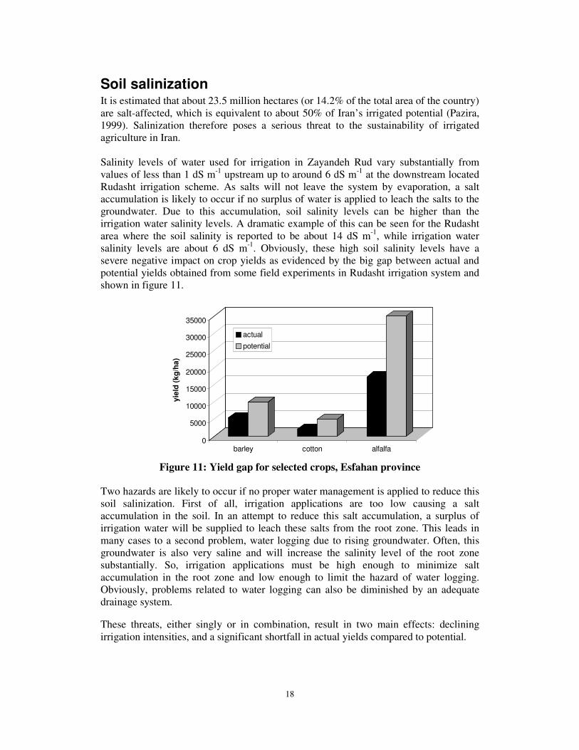
Soil salinization It is estimated that about 23.5 million hectares (or 14.2% of the total area of the country) are salt-affected, which is equivalent to about 50% of Iran’s irrigated potential (Pazira, 1999). Salinization therefore poses a serious threat to the sustainability of irrigated agriculture in Iran. Salinity levels of water used for irrigation in Zayandeh Rud vary substantially from values of less than 1 dS m-1 upstream up to around 6 dS m-1 at the downstream located Rudasht irrigation scheme. As salts will not leave the system by evaporation, a salt accumulation is likely to occur if no surplus of water is applied to leach the salts to the groundwater. Due to this accumulation, soil salinity levels can be higher than the irrigation water salinity levels. A dramatic example of this can be seen for the Rudasht area where the soil salinity is reported to be about 14 dS m-1, while irrigation water salinity levels are about 6 dS m-1. Obviously, these high soil salinity levels have a severe negative impact on crop yields as evidenced by the big gap between actual and potential yields obtained from some field experiments in Rudasht irrigation system and shown in figure 11.
Figure 11: Yield gap for selected crops, Esfahan province Two hazards are likely to occur if no proper water management is applied to reduce this soil salinization. First of all, irrigation applications are too low causing a salt accumulation in the soil. In an attempt to reduce this salt accumulation, a surplus of irrigation water will be supplied to leach these salts from the root zone. This leads in many cases to a second problem, water logging due to rising groundwater. Often, this groundwater is also very saline and will increase the salinity level of the root zone substantially. So, irrigation applications must be high enough to minimize salt accumulation in the root zone and low enough to limit the hazard of water logging. Obviously, problems related to water logging can also be diminished by an adequate drainage system. These threats, either singly or in combination, result in two main effects: declining irrigation intensities, and a significant shortfall in actual yields compared to potential.
0
5000
10000
15000
20000
25000
30000
35000
yiel
d (k
g/ha
)
barley cotton alfalfa
actualpotential

19
Reducing threats to sustainable agriculture The Iran-IWMI Collaborative Research project was established to identify ways in which the main threats to sustainable irrigated agriculture could be alleviated. The program is a four year collaboration between the Iranian Agricultural Engineering Research Institute (IAERI), based in Karaj, the Agricultural Engineering Department of the Esfahan Agricultural Research Center (EARC), and the International Water Management Institute (IWMI). The project has adopted a joint program of training and research to accomplish its aims, and uses the Zayandeh Rud as its main research location. In the later stages of the project it is hoped to extend the methodologies developed in Esfahan to other parts of Iran. Three elements of the project distinguish it from other water management studies in Iran:
• The use of an integrated approach to basin-irrigation system-field level studies (referred to as the IWMI water resources paradigm [Perry, 1999]) that looks not only at problems at different levels in a river basin but also examines the interactions between them. The scope of the study ranges from operation and management of water resources at the main reservoir downwards through irrigation system management to farm level irrigated agricultural practices.
• The use of information technology and modeling to understand the dynamics within each level, as well as the inter-relationships between them. Currently five different model approaches are being adopted:
- basin level hydrologic modeling that assesses inflows into the reservoir and the downstream hydrology as affected by extractions of water for different uses;
- river water quality modeling to examine relationships between the main sources of pollution and the rate of decrease in water quality in the Zayandeh Rud;
- groundwater hydrologic and quality modeling to determine the changes in water table levels, the deterioration of groundwater resources over time, and the impacts of groundwater-based irrigation on water availability and quality;
- soil-water-atmosphere-plant modeling to assess water and salt balance at field level, determine the productivity of water at field level and to examine causes of yield gaps;
- irrigation system assessment using aggregated field level models that determine performance for different combinations of soil, crop and irrigation water application.
• The extensive use of already existing information and remotely sensed data.
IWMI researchers have already demonstrated that basin modeling can be successfully performed using publicly available data sets (Lacroix, Kite and Droogers, forthcoming) and remote sensing data (Droogers and Kite, 2000).

20
At the end of the current phase of the project a series of possible remedial actions will have been proposed whose adoption can provide a sustainable basis for irrigated agriculture in the Zayandeh Rud.
Acknowledgements Numerous agencies, notably the Ministry of Agriculture and the Ministry of Energy, allowed us access to their databases and provided us with essential information for our studies. Their cooperation and support is gratefully acknowledged.
Literature Cited Droogers, P., and G.W. Kite, 2000. Remotely sensed data used for modeling at different
hydrological scales. Hydrological Processes (in press). Gieske, A., M. Miranzadeh, and A. Mamanpoush.. 2000. Groundwater chemistry of the
Lenjanat district, Esfahan province, Iran. IEARI-EARC-IWMI Research Report i Kalbasi, M. and S.F. Mousavi. 1995. Seven-year study of fluctuations in N, P, EC and
pH of the Zayandehrud river. Proceedings of the Regional Conference on Water Resources Management, 28-30 August 1995, Isfahan, Iran. p.151 (English abstract).
Lacroix, M., G. Kite and P. Droogers. 2000. Distributed basin modeling using only
public-domain datasets. Water Resources Research (submitted). Pazira, E. 1999. Land reclamation research on soil physico-chemical improvement by
salt leaching in southwest part of Iran. IERI, Karaj, Iran Perry, C. J. 1999. The IWMI water resources paradigm: Definitions and implications.
Agricultural Water Management, 40(1):45-50.

21
The following reports have been published in the IAERI-IWMI Research Report series. 1. Water Management for Sustainable Irrigated Agriculture in the Zayandeh
Rud Basin, Esfahan Province, Iran. (2000) H.R. Salemi, A. Mamanpoush, M. Miranzadeh, M. Akbari, M. Torabi, N. Toomanian, H. Murray-Rust, P. Droogers, H. Sally, A. Gieske.
2. Exploring field scale salinity using simulation modeling, example for Rudasht area, Esfahan Province, Iran. (2000) P. Droogers, M. Akbari, M. Torabi, E. Pazira.
3. An overview of the hydrology of the Zayandeh Rud Basin. (2000) H. Murray-Rust, H. Sally, H.R. Salemi, A. Mamanpoush.
4. Groundwater chemistry of the Lenjanat District, Esfahan Province, Iran. (2000) A. Gieske, M. Miranzadeh, A. Mamanpoush.
5. Exploring basin scale salinity problems using a simplified water accounting model: the example of Zayandeh Rud Basin, Iran. (2000) P. Droogers, H.R. Salemi, A. Mamanpoush.
6. Sustainable irrigation and water management in the Zayandeh Rud Basin. Proceedings of Workshop in Esfahan, Iran, 19-21 November 2000. (2001) Anonymous.
7. Assessment of irrigation performance using NOAA satellite imagery. (2001) P. Droogers, P., W.G.M. Bastiaanssen, A. Gieske, N. Toomanian, M. Akbari.
8. Water supply and demand in four major irrigation systems in the Zayandeh Rud Basin, Iran. (2001) H. Sally, H. Murray-Rust, A.R. Mamanpoush, M. Akbari.
9. Spatial analysis of groundwater trends: example for Zayandeh Rud Basin, Iran. (2001) P. Droogers, M. Miranzadeh.
10. Irrigated area by NOAA-Landsat upscaling techniques: Zayandeh Rud Basin, Iran. (2002) A. Gieske, N. Toomanian, M. Akbari.
11. Crop and land cover classification by LANDSAT 7 ETM (July 2000) for the Zayandeh Rud basin. (2002). A.Gieske, A.R. Mamanpoush, M. Akbari, M. Miranzadeh.
12. Field scale scenarios for water and salinity management by simulation modeling. (2002) P. Droogers and M. Torabi.
13. Water Supply and Demand Forecasting for the Zayandeh Rud. (2002). H.R. Salemi and H. Murray-Rust.
14. Water Resources Development and Water Utilization in the Zayandeh Rud Basin, Iran. (2002). H. Murray-Rust, H.R. Salemi and P. Droogers.
15. Groundwater resources modeling of the Lenjanat aquifer system. (2002). A. Gieske and M. Miranzadeh.