
Statement of Qualifications Walney Road Bridge Replacement ...

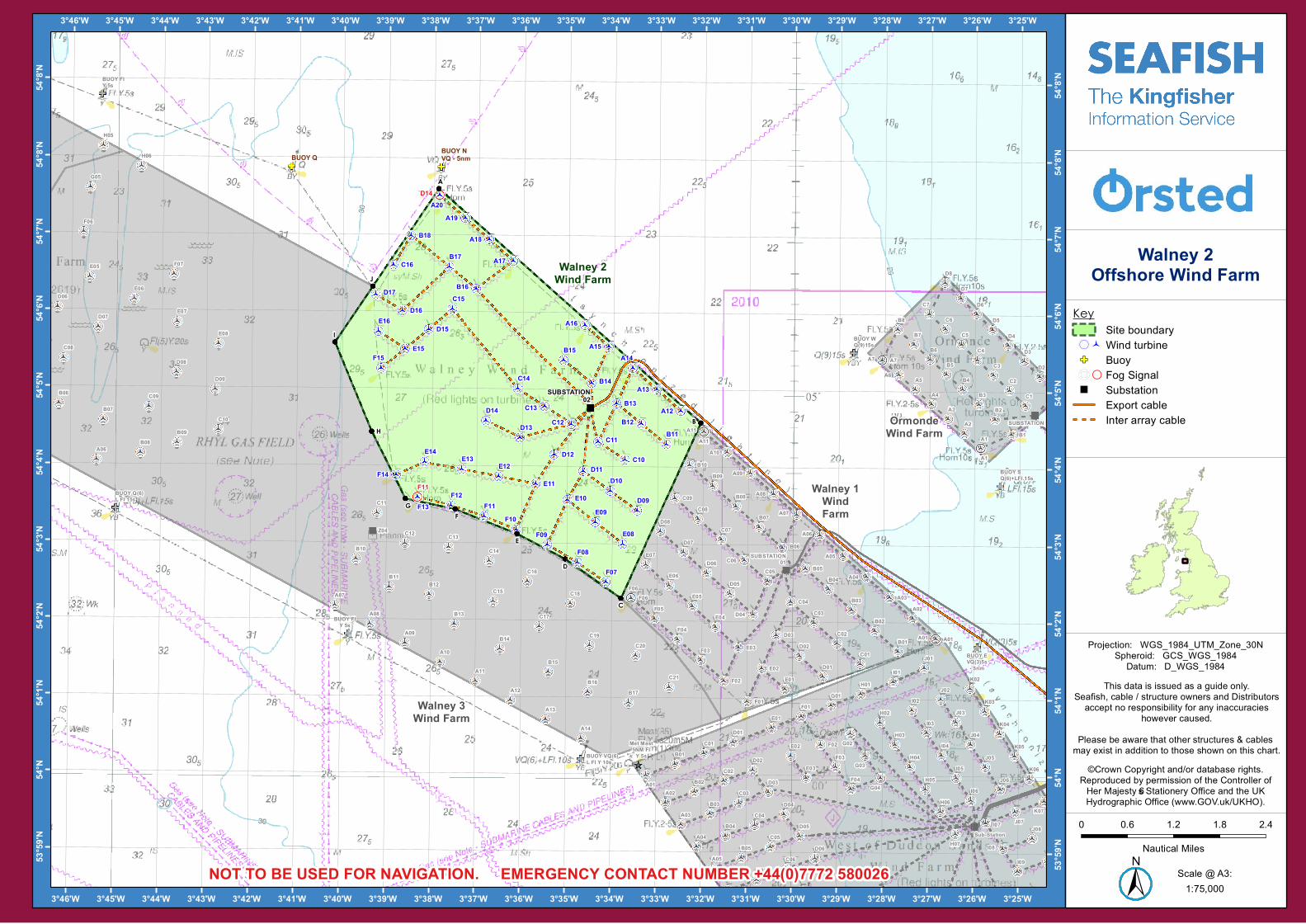
The Walney 2 Offshore Wind Farm is operated by Orsted (formally DONG Energy). It is situated approximately 14 km from shore in the East Irish Sea, off the North Lancashire coast. The wind farm is fully operational and has 51 turbines, a total capacity of 183 MW and covers an area of approximately 45 km².
WALNEY 2 OFFSHORE WIND FARM JANUARY 2018
ADMIRALTY CHART OF WIND FARM HERE
+44(0)7772 580026
1. If you suspect you have snagged a subsea cable or renewable energy structure, DO NOT endanger your vessel and crew by attempting to recover your gear.
2. Carefully plot your vessel’s position as accurately as possible.
3. Advise the Coastguard of your situation, and call the 24 hour Emergency Number and state that an incident is occurring concerning a subsea cable or renewable energy structure.
A1
A2
A3
A4
A5A6
A7
B1
B2
B3
B4
B5
B6
B7
B8
C1
C2
C3
C4
C5
C6
C7
D2
D3
D4
D5
D6
D7
D8
C06
D04
E03
F02
D05
D07
C05
C04
D08C07
C08C09 A08
A09B09B10
B07
B08
F01
E02
D02
D01
C03
C02
B04
B03
C01B01
B02
E01
A01
A02A03
A04
A05
A06B06
B05
A07
D06E07
E06
A10
A11
E05
E04F05
F06
F04
F03
D03
A06
A07
A08
A09
A10
A11
A12
A13
A14
B06
B07
B08B09
B10
B11B12
B13
B14
B15
B16B17
C08
C09
C10
C11
C12 C13
C14
C15
C16
C17
C18
C19C20
C21
D06
D07
D08
D09
E05
E06
E07
E08
F06
F07
G05
H05
H06
A01A02
A03
A04
A05
B01
B02
B03
B04
B05
B06
C01
C02
C03
C04
C05
C06
D01
D02
D03
D04
D05
D06
E01
E02
E03
F01
F02
F03
F04
G01
G02
G03
G04
H01
H02
H03
H04
H05
H06
H07
I01
I02
I03
I04
I05
I06
I07
I08
I09
J01
J02
J03
J04
J05
J06
J07J08
K02
K03
K04
K05
K06
K07
E09
B12
B15
C13
D12
F15
E08
D09
E14
F11F13
C10
C11 B11
E16
E10
A12
A18
A19
B16
C14
E12E13
B14
D10
E15
F08
A15
B13
D13
D15
B18
C15
D11
D17
A20
C12
F14E11
F07
A16
B17
D14
C16
F09F10
F12
A13
A14
A17
D16
SUBSTATION
SUBSTATION01
Z04
Sub-Station
SUBSTATION02
Met Mast5NM FI
Y 5s
A1
A7
A11
A01
F06
D14
F11
BUOY WQ(9)15s
BUOY SQ(6)+LFl.15s
BUOY EVQ(3)5s
- 5nm
BUOY FIY 5s
BUOY VQ(6)L Fl Y 10s
BUOY FlY 5s
BUOY Q(6)L FI 15s
BUOY NVQ - 5nmBUOY Q
OrmondeWind Farm
Walney 1WindFarm
Walney 3Wind Farm
Walney 2Wind Farm
A
B
C
D
E
FG
H
I
J
3°25'W
3°25'W
3°26'W
3°26'W
3°27'W
3°27'W
3°28'W
3°28'W
3°29'W
3°29'W
3°30'W
3°30'W
3°31'W
3°31'W
3°32'W
3°32'W
3°33'W
3°33'W
3°34'W
3°34'W
3°35'W
3°35'W
3°36'W
3°36'W
3°37'W
3°37'W
3°38'W
3°38'W
3°39'W
3°39'W
3°40'W
3°40'W
3°41'W
3°41'W
3°42'W
3°42'W
3°43'W
3°43'W
3°44'W
3°44'W
3°45'W
3°45'W
3°46'W
3°46'W54
°8'N
54°8'
N
54°8'
N
54°8'
N
54°7'
N
54°7'
N
54°6'
N
54°6'
N
54°5'
N
54°5'
N
54°4'
N
54°4'
N
54°3'
N
54°3'
N
54°2'
N
54°2'
N
54°1'
N
54°1'
N
54°N
54°N
53°59
'N
53°59
'N
0 0.6 1.2 1.8 2.4
Nautic al Mile s
1:75,000Scale @ A3:
Walney 2Offshore Wind Farm
±NOT TO BE USED FOR NAVIGATION. EMERGENCY CONTACT NUMBER +44(0)7772 580026
©Crown Copyright and/or database rights.Re produc e d by pe rm ission of the Controlle r ofHe r Maje sty’s Statione ry O ffic e and the UKHydrographic O ffic e (www.GO V.uk/UKHO ).
This data is issue d as a guide only.Se afish, cable / structure owne rs and Distributorsac c e pt no re sponsibility for any inac c urac ie s
howe ve r c ause d.Ple ase be aware that othe r struc ture s & cable s m ay e xist in addition to those shown on this c hart.
KeySite boundary
( Wind turbineGF Buoy Fog Signal" Substation
Export cableInte r array cable
Proje c tion: WGS_1984_UTM_ Z one _ 30NSphe roid: GCS_WGS_1984Datum : D_WGS_1984

EXTENT COORDINATES
A 54°07.603'N 03°37.894'W
B 54°04.583'N 03°32.061'W
C 54°02.300'N 03°33.804'W
D 54°02.802'N 03°35.038'W
E 54°03.128'N 03°36.105'W
F 54°03.441'N 03°37.479'W
G 54°03.572'N 03°38.578'W
H 54°04.441'N 03°39.341'W
I 54°05.597'N 03°40.170'W
J 54°06.328'N 03°39.341'W
TURBINES
A12 54°04.741'N 03°32.506'W
A13 54°05.017'N 03°33.039'W
A14 54°05.294'N 03°33.572'W
A15 54°05.570'N 03°34.106'W
A16 54°05.846'N 03°34.639'W
A17 54°06.675'N 03°36.240'W
A18 54°06.951'N 03°36.774'W
A19 54°07.227'N 03°37.308'W
A20 54°07.522'N 03°37.877'W
B11 54°04.307'N 03°32.823'W
B12 54°04.570'N 03°33.376'W
B13 54°04.832'N 03°33.929'W
B14 54°05.094'N 03°34.483'W
B15 54°05.389'N 03°35.106'W
B16 54°06.311'N 03°37.057'W
B17 54°06.593'N 03°37.652'W
B18 54°06.995'N 03°38.503'W
C10 54°04.102'N 03°33.734'W
C11 54°04.331'N 03°34.329'W
C12 54°04.559'N 03°34.924'W
C13 54°04.788'N 03°35.518'W
C14 54°05.016'N 03°36.114'W
C15 54°06.043'N 03°37.574'W
C16 54°06.612'N 03°38.890'W
D09 54°03.440'N 03°33.455'W
D10 54°03.694'N 03°34.055'W
INFRASTRUCTURE
BUOY N VQ - 5nm 54°07.890'N 03°37.850'W
BUOY Q 54°07.880'N 03°41.169'W
Fog Signal D14 54°07.522'N 03°37.877'W
Fog Signal F11 54°03.595'N 03°38.316'W
SUBSTATION 02 54°04.771'N 03°34.507'W
TURBINES
D11 54°03.948'N 03°34.655'W
D12 54°04.160'N 03°35.302'W
D13 54°04.378'N 03°36.057'W
D14 54°04.596'N 03°36.812'W
D15 54°05.776'N 03°38.096'W
D16 54°06.018'N 03°38.682'W
D17 54°06.228'N 03°39.276'W
E08 54°03.006'N 03°33.772'W
E09 54°03.285'N 03°34.377'W
E10 54°03.573'N 03°35.02'W
E11 54°03.778'N 03°35.703'W
E12 54°03.870'N 03°36.522'W
E13 54°03.962'N 03°37.341'W
E14 54°04.054'N 03°38.161'W
E15 54°05.522'N 03°38.618'W
E16 54°05.748'N 03°39.208'W
F07 54°02.508'N 03°34.135'W
F08 54°02.762'N 03°34.770'W
F09 54°02.988'N 03°35.435'W
F10 54°03.185'N 03°36.125'W
F11 54°03.353'N 03°36.838'W
F12 54°03.490'N 03°37.570'W
F13 54°03.595'N 03°38.316'W
F14 54°03.885'N 03°38.787'W
F15 54°05.268'N 03°39.140'W