Volcano Hazards, including Lahars - Seattle.gov Home Office of Emergency Management Seattle Hazard...
17
Seattle Office of Emergency Management Seattle Hazard Identification and Vulnerability Analysis Volcano Hazards, including Lahars Key Points Washington State is home to five active volcanoes located in the Cascade Range east of Seattle: Mt. Baker, Glacier Peak, Mt. Rainier, Mt. Adams and Mt. St. Helens. Washington and California are the only states in the lower 48 to experience a major volcanic eruption in the past 150 years. Major hazards caused by eruptions are blast, pyroclastic flows, lahars and ash fall. Seattle is too far from volcanoes, including Mt. Rainier, to receive damage from blast and pyroclastic flows. Ash falls could reach Seattle from any volcano, but prevailing weather patterns would probably blow ash away from Seattle. Mt. Rainier and Glacier Peak are closest volcanoes to Seattle and therefore the most likely ash sources. To underscore this uncertainty, ash deposits from a pre-historic eruption were recently found in Seattle. The deposit’s source could not be identified. The City of Seattle depends on power, water and transportation resources located in the Cascades and Eastern Washington where ash could fall. Seattle City Light operates dams directly east of Mt. Baker and in Pend Oreille County in eastern Washington and would be in the likely path of an ash cloud. Seattle water comes from two reservoirs located in the Central Cascades. They are outside the probable path of an ash cloud. If ash were to strike Seattle it would create health problems, paralyze the transportation system, destroy many mechanical objects, endanger the utility networks and cost millions of dollars to clean up. The United States Geological Survey defines lahars as “mudflows and debris flows that originate from the slopes of a volcano.” Lahars contain high concentrations of rock debris and can travel tens of meters per second. Most, but not all, are preceded by volcanic and seismic activity. Of the five Cascade volcanoes, Mt. Rainier is the most significant threat. Lahars from Mt. Rainier have buried the Kent Valley, but there is no evidence a lahar has reached Seattle in the past 10,000 years. An USGS analysis states that it is possible for a lahar to reach Seattle, but would be extremely unlikely. Although the risk of lahars seems quite small, some uncertainty exists because the last lahars occurred thousands of years ago before development. It is not understood whether or how the development will affect a lahar. Seattle has a high probability of “post-lahar sedimentation.” A lahar is likely to stop in the Kent Valley, then the next big storm transports loose material from the lahar down the Green and Duwamish Rivers, causing problems for the maritime community. Context Washington has five active volcanoes. They are part of the same tectonic motion that gives the Pacific Northwest its seismic activity. As the earth’s continent and ocean-sized plates move, the heavier ocean plates slip under the lighter continental plates. This process is called “subduction” and it causes friction along the plate faces. Typically, the hottest part of the subduction area is under the continental plate about 100-200 miles inland from the coast, where the heat and pressure melt the plates into magma. The hot, molten rock forms reservoirs near the surface. As the rock melts it seeks to expand. Under normal conditions, the constraining pressure of the surrounding rock keeps the expansive force of the molten rock in check. An eruption is triggered when the balance of forces is upset. Sometimes an increase in pressure from
-
Upload
nguyenngoc -
Category
Documents
-
view
215 -
download
0
Transcript of Volcano Hazards, including Lahars - Seattle.gov Home Office of Emergency Management Seattle Hazard...
Seattle Office of Emergency Management Seattle Hazard Identification and Vulnerability Analysis
Volcano Hazards, including Lahars
Key Points
Washington State is home to five active volcanoes located in the Cascade Range east of Seattle: Mt. Baker, Glacier Peak, Mt. Rainier, Mt. Adams and Mt. St. Helens. Washington and California are the only states in the lower 48 to experience a major volcanic eruption in the past 150 years.
Major hazards caused by eruptions are blast, pyroclastic flows, lahars and ash fall.
Seattle is too far from volcanoes, including Mt. Rainier, to receive damage from blast and pyroclastic flows.
Ash falls could reach Seattle from any volcano, but prevailing weather patterns would probably blow ash away from Seattle. Mt. Rainier and Glacier Peak are closest volcanoes to Seattle and therefore the most likely ash sources. To underscore this uncertainty, ash deposits from a pre-historic eruption were recently found in Seattle. The deposit’s source could not be identified.
The City of Seattle depends on power, water and transportation resources located in the Cascades and Eastern Washington where ash could fall. Seattle City Light operates dams directly east of Mt. Baker and in Pend Oreille County in eastern Washington and would be in the likely path of an ash cloud. Seattle water comes from two reservoirs located in the Central Cascades. They are outside the probable path of an ash cloud.
If ash were to strike Seattle it would create health problems, paralyze the transportation system, destroy many mechanical objects, endanger the utility networks and cost millions of dollars to clean up.
The United States Geological Survey defines lahars as “mudflows and debris flows that originate from the slopes of a volcano.” Lahars contain high concentrations of rock debris and can travel tens of meters per second. Most, but not all, are preceded by volcanic and seismic activity.
Of the five Cascade volcanoes, Mt. Rainier is the most significant threat. Lahars from Mt. Rainier have buried the Kent Valley, but there is no evidence a lahar has reached Seattle in the past 10,000 years. An USGS analysis states that it is possible for a lahar to reach Seattle, but would be extremely unlikely.
Although the risk of lahars seems quite small, some uncertainty exists because the last lahars occurred thousands of years ago before development. It is not understood whether or how the development will affect a lahar.
Seattle has a high probability of “post-lahar sedimentation.” A lahar is likely to stop in the Kent Valley, then the next big storm transports loose material from the lahar down the Green and Duwamish Rivers, causing problems for the maritime community.
Context
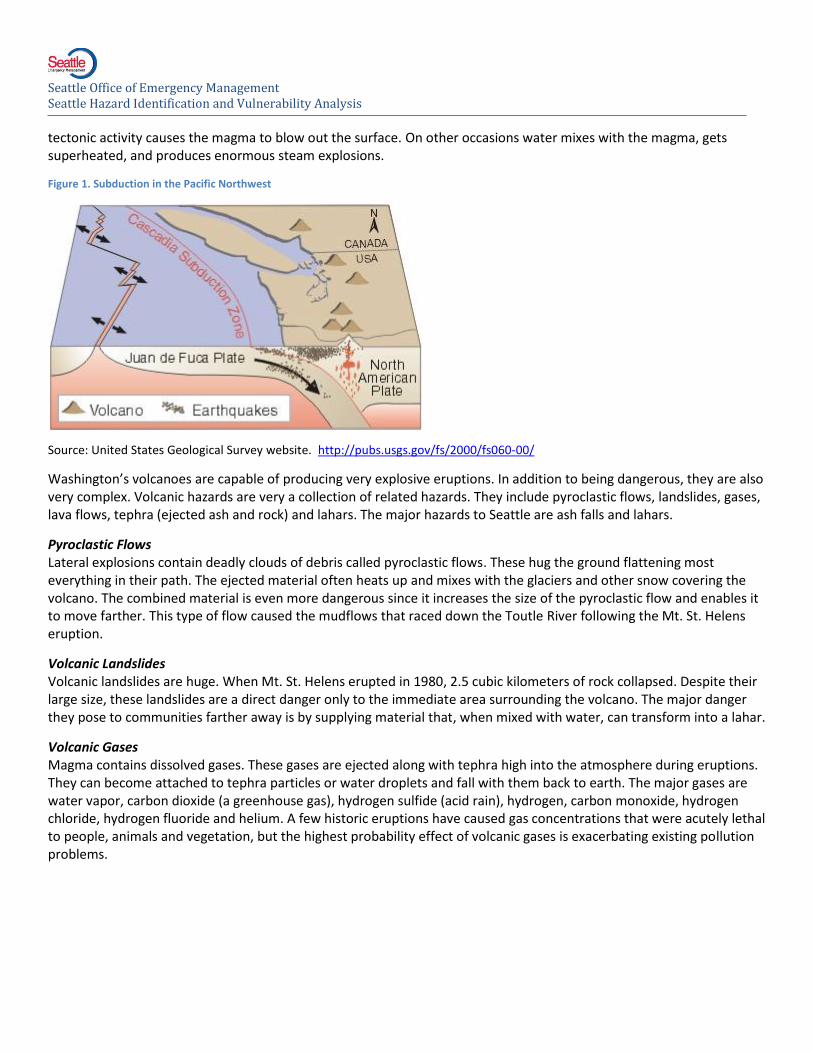
Washington has five active volcanoes. They are part of the same tectonic motion that gives the Pacific Northwest its seismic activity. As the earth’s continent and ocean-sized plates move, the heavier ocean plates slip under the lighter continental plates. This process is called “subduction” and it causes friction along the plate faces. Typically, the hottest part of the subduction area is under the continental plate about 100-200 miles inland from the coast, where the heat and pressure melt the plates into magma. The hot, molten rock forms reservoirs near the surface. As the rock melts it seeks to expand.
Under normal conditions, the constraining pressure of the surrounding rock keeps the expansive force of the molten rock in check. An eruption is triggered when the balance of forces is upset. Sometimes an increase in pressure from
Seattle Office of Emergency Management Seattle Hazard Identification and Vulnerability Analysis
tectonic activity causes the magma to blow out the surface. On other occasions water mixes with the magma, gets superheated, and produces enormous steam explosions.
Figure 1. Subduction in the Pacific Northwest
Source: United States Geological Survey website. http://pubs.usgs.gov/fs/2000/fs060-00/
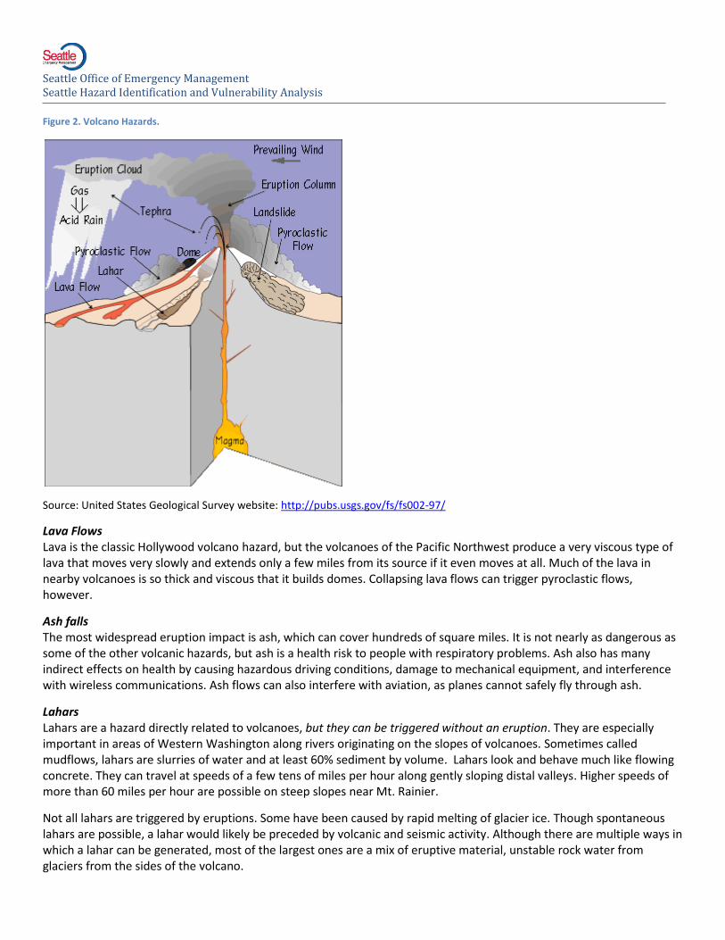
Washington’s volcanoes are capable of producing very explosive eruptions. In addition to being dangerous, they are also very complex. Volcanic hazards are very a collection of related hazards. They include pyroclastic flows, landslides, gases, lava flows, tephra (ejected ash and rock) and lahars. The major hazards to Seattle are ash falls and lahars.
Pyroclastic Flows Lateral explosions contain deadly clouds of debris called pyroclastic flows. These hug the ground flattening most everything in their path. The ejected material often heats up and mixes with the glaciers and other snow covering the volcano. The combined material is even more dangerous since it increases the size of the pyroclastic flow and enables it to move farther. This type of flow caused the mudflows that raced down the Toutle River following the Mt. St. Helens eruption.
Volcanic Landslides Volcanic landslides are huge. When Mt. St. Helens erupted in 1980, 2.5 cubic kilometers of rock collapsed. Despite their large size, these landslides are a direct danger only to the immediate area surrounding the volcano. The major danger they pose to communities farther away is by supplying material that, when mixed with water, can transform into a lahar.
Volcanic Gases Magma contains dissolved gases. These gases are ejected along with tephra high into the atmosphere during eruptions. They can become attached to tephra particles or water droplets and fall with them back to earth. The major gases are water vapor, carbon dioxide (a greenhouse gas), hydrogen sulfide (acid rain), hydrogen, carbon monoxide, hydrogen chloride, hydrogen fluoride and helium. A few historic eruptions have caused gas concentrations that were acutely lethal to people, animals and vegetation, but the highest probability effect of volcanic gases is exacerbating existing pollution problems.
Seattle Office of Emergency Management Seattle Hazard Identification and Vulnerability Analysis
Figure 2. Volcano Hazards.
Source: United States Geological Survey website: http://pubs.usgs.gov/fs/fs002-97/
Lava Flows Lava is the classic Hollywood volcano hazard, but the volcanoes of the Pacific Northwest produce a very viscous type of lava that moves very slowly and extends only a few miles from its source if it even moves at all. Much of the lava in nearby volcanoes is so thick and viscous that it builds domes. Collapsing lava flows can trigger pyroclastic flows, however.
Ash falls The most widespread eruption impact is ash, which can cover hundreds of square miles. It is not nearly as dangerous as some of the other volcanic hazards, but ash is a health risk to people with respiratory problems. Ash also has many indirect effects on health by causing hazardous driving conditions, damage to mechanical equipment, and interference with wireless communications. Ash flows can also interfere with aviation, as planes cannot safely fly through ash.
Lahars Lahars are a hazard directly related to volcanoes, but they can be triggered without an eruption. They are especially important in areas of Western Washington along rivers originating on the slopes of volcanoes. Sometimes called mudflows, lahars are slurries of water and at least 60% sediment by volume. Lahars look and behave much like flowing concrete. They can travel at speeds of a few tens of miles per hour along gently sloping distal valleys. Higher speeds of more than 60 miles per hour are possible on steep slopes near Mt. Rainier.
Not all lahars are triggered by eruptions. Some have been caused by rapid melting of glacier ice. Though spontaneous lahars are possible, a lahar would likely be preceded by volcanic and seismic activity. Although there are multiple ways in which a lahar can be generated, most of the largest ones are a mix of eruptive material, unstable rock water from glaciers from the sides of the volcano.
Seattle Office of Emergency Management Seattle Hazard Identification and Vulnerability Analysis
Lahars can travel tens of miles from their source, making them extremely dangerous to communities close to volcanoes. After a lahar initially stops, it can still be a hazard. “Post-lahar sedimentation” is the incremental transport of excess sediment from the headwaters of a river to lower river reaches that occurs days, weeks even years after a lahar occurrence. The resulting rise in sediment is a risk to navigation and the environment.
History
Since 1780, four of the five active volcanoes near Seattle have erupted. These are Mt. Baker, Glacier Peak, Mt. Rainier, Mt. St. Helens and Mt. Hoodi. Only Mt. Adams has been inactive. There was a flurry of small-scale activity in the 19th century. Only two volcanoes have fully erupted in the Cascades in the 20th century, Mt. Lassen in northern California in 1917 and Mt. St. Helens in 1980.
Each volcano has its own character and history.
Mt. Baker has been active with small scale events since pioneer settlement. Large volume events have occurred about once every 150 years during the past 600 years ii. Several post-ice age eruptions have produced mudflows but only light ash falls near the mountain.
Glacier Peak generated a sequence of nine tephra eruptions over a period of several hundred years about 13,000 years ago. The largest ejected more than five times as much tephra as the 1980 Mt. St. Helens eruption. Glacier Peak’s more recent eruptions, including one just 220 years ago, have not been as violent but have sent mudflows down to the Skagit on several occasions. Some of them reached the Puget Lowlandsiii.
Mt. Rainier has erupted in the historic period. Explorers and pioneers tell of smoke and earthquakes near the mountain, but there is no historical evidence of major mudflows or ash falls. Stephen Harris investigated these stories and suspects most were steam eruptions and not the more violent Plinian typeiv. Geologic records show Rainier was active 6,500 to 4,500 years ago and again 2,500 to 2,000 years ago. Most of this eruptive activity produced little ash but large mudflows, also known as lahars.
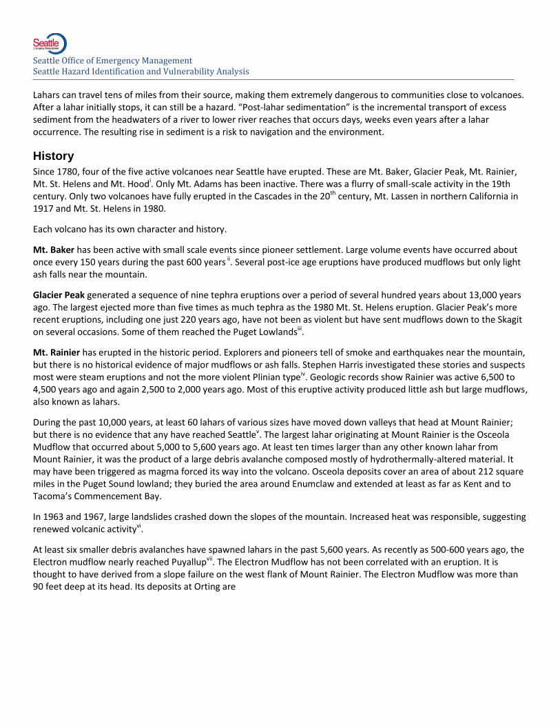
During the past 10,000 years, at least 60 lahars of various sizes have moved down valleys that head at Mount Rainier; but there is no evidence that any have reached Seattlev. The largest lahar originating at Mount Rainier is the Osceola Mudflow that occurred about 5,000 to 5,600 years ago. At least ten times larger than any other known lahar from Mount Rainier, it was the product of a large debris avalanche composed mostly of hydrothermally-altered material. It may have been triggered as magma forced its way into the volcano. Osceola deposits cover an area of about 212 square miles in the Puget Sound lowland; they buried the area around Enumclaw and extended at least as far as Kent and to Tacoma’s Commencement Bay.
In 1963 and 1967, large landslides crashed down the slopes of the mountain. Increased heat was responsible, suggesting renewed volcanic activityvi.
At least six smaller debris avalanches have spawned lahars in the past 5,600 years. As recently as 500-600 years ago, the Electron mudflow nearly reached Puyallupvii. The Electron Mudflow has not been correlated with an eruption. It is thought to have derived from a slope failure on the west flank of Mount Rainier. The Electron Mudflow was more than 90 feet deep at its head. Its deposits at Orting are
Seattle Office of Emergency Management Seattle Hazard Identification and Vulnerability Analysis
Figure 3. Osceola and Electron Mudflows
Source: United States Geological Survey website: http://vulcan.wr.usgs.gov/Volcanoes/Rainier/Maps/osceola_map.html
as much as 18 feet thick and contain remnants of an old-growth forest. About 1,200 years ago, a lahar of this type filled valleys of both forks of the White River to depths of 60 to 90 feet and flowed 60 miles. Less than 2,200 years ago, the National Lahar inundated the Nisqually River valley to depths of 30-120 feet and flowed all the way to Puget Sound. More than a dozen lahars of this type have occurred at Mount Rainier during periods of volcanism in the past 6,000 years.
Mt. St. Helens. The 1980 eruption was the largest in the Cascades in historic times but only produced trace ash dustings in Seattle. Mt. St. Helens has been consistently the most explosive of the Cascade volcanoes, with earlier, smaller

Seattle Office of Emergency Management Seattle Hazard Identification and Vulnerability Analysis
eruptions in 1800, 1831, 1842 and 1857viii. Mt. St. Helens is the most prolific tephra (ash) producer of the past few thousand years because of the frequency of its eruptions.
Mt. Adams has erupted in recent geologic time although not since written records began. Most of these eruptions were fairly quiet with little ash or pyroclastic material. Some observers speculate that it is dormant or extinct, but the Cascades Volcano Observatory thinks it could have minor eruptions againix.
Mt. Hood has been very active recently, with eruptive periods between 1,500 - 1,800 and 200 - 250 years ago. Harris concludes there were small eruptions in the 19th century. The ash fall and pyroclastic flows have been limited to Oregon and southern Washingtonx. Mt. Hood is more of a threat to Portland than Seattle.
Likelihood
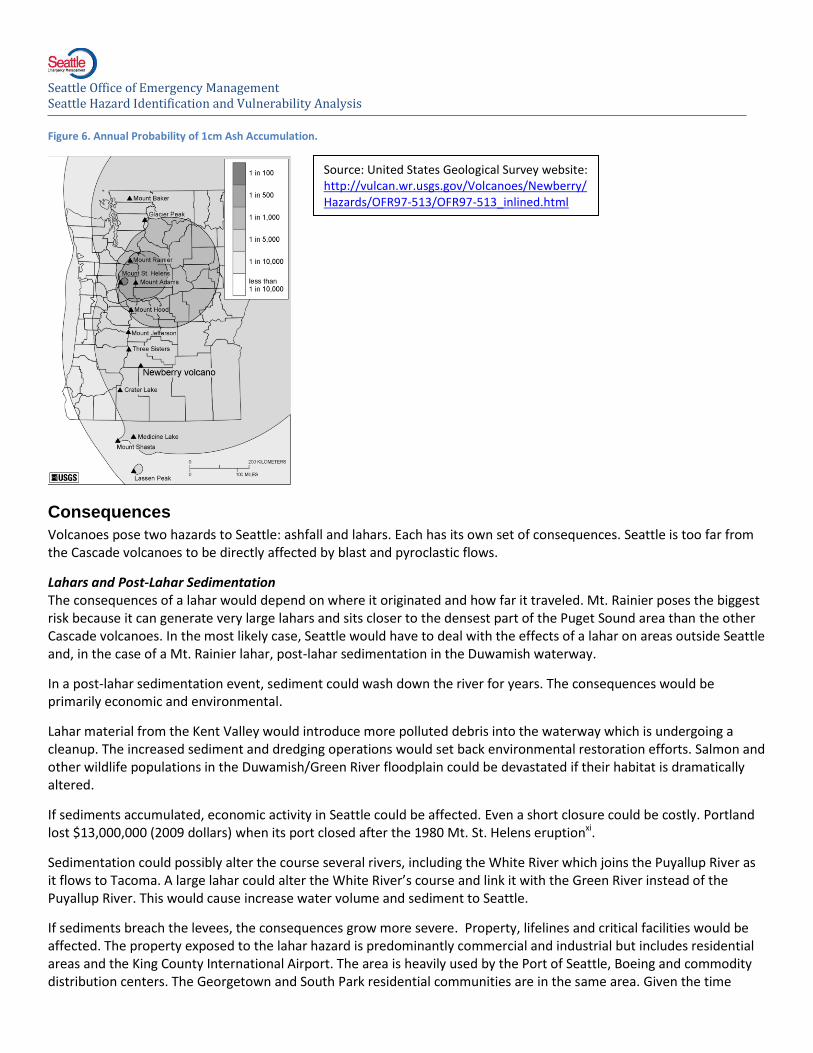
The USGS estimates that Seattle has an annual probability of 10 centimeters or more accumulation of 0.01% (1 in 10,000). The USGS has produced a map showing annual probabilities of 1cm ash accumulation. Seattle is more likely to receive ash from Mt. Shasta, in California, then volcanoes in Washington State.
Lahars happen more commonly than eruptions. Mt. Rainier is a major producer of lahars because of its size, relatively westward location, and the volume of water trapped in the glaciers along its slopes. Most Cascade glaciers, including those on Mt. Rainier, are shrinking. As they retreat very unstable terrain is exposed. As a result, small debris flows are becoming more common and the released sediment is being washed downstream. This, in turn, decreases the capacity of rivers originating at Mt. Rainier and makes them more likely to overflow their banks with water or lahar debris. Despite all the suggestive evidence, these changes are so new the effects have not been studied comprehensively and many gaps in understanding remain to be filled.
Vulnerability
Seattle is vulnerable to two volcano hazards: ashfall and lahars. Seattle could be affected by only one or both.
Lahar Vulnerability Seattle’s Duwamish river valley is exposed to lahars and a process known as post-lahar sedimentation. The Kent Valley is more likely than Seattle to be directly affected by a lahar. The whole city is indirectly exposed to potential damage in the Kent Valley because it is heavily dependent on lifelines and facilities located in the area.
Seattle is downstream from Mount Rainier, the Pacific Northwest’s major lahar producer. Seattle’s major river, the Duwamish, originates on Mt. Rainier’s slopes. A lahar could reach Seattle, but geologists have not found evidence that they have. It is most likely that a lahar would stop in the south of Seattle in the Kent Valley. Then in the coming days, weeks or months, lahar sediments would push downstream to Seattle in a process known as post-lahar sedimentation.
Hydrologists state that levees will probably contain the sediment inside the river channel but cannot provide guarantees. Therefore most of the Sodo area should be considered at risk of inundation. Containing the sediment depends on its volume, its speed, the time of year, and the levees’ condition. If
Seattle Office of Emergency Management Seattle Hazard Identification and Vulnerability Analysis
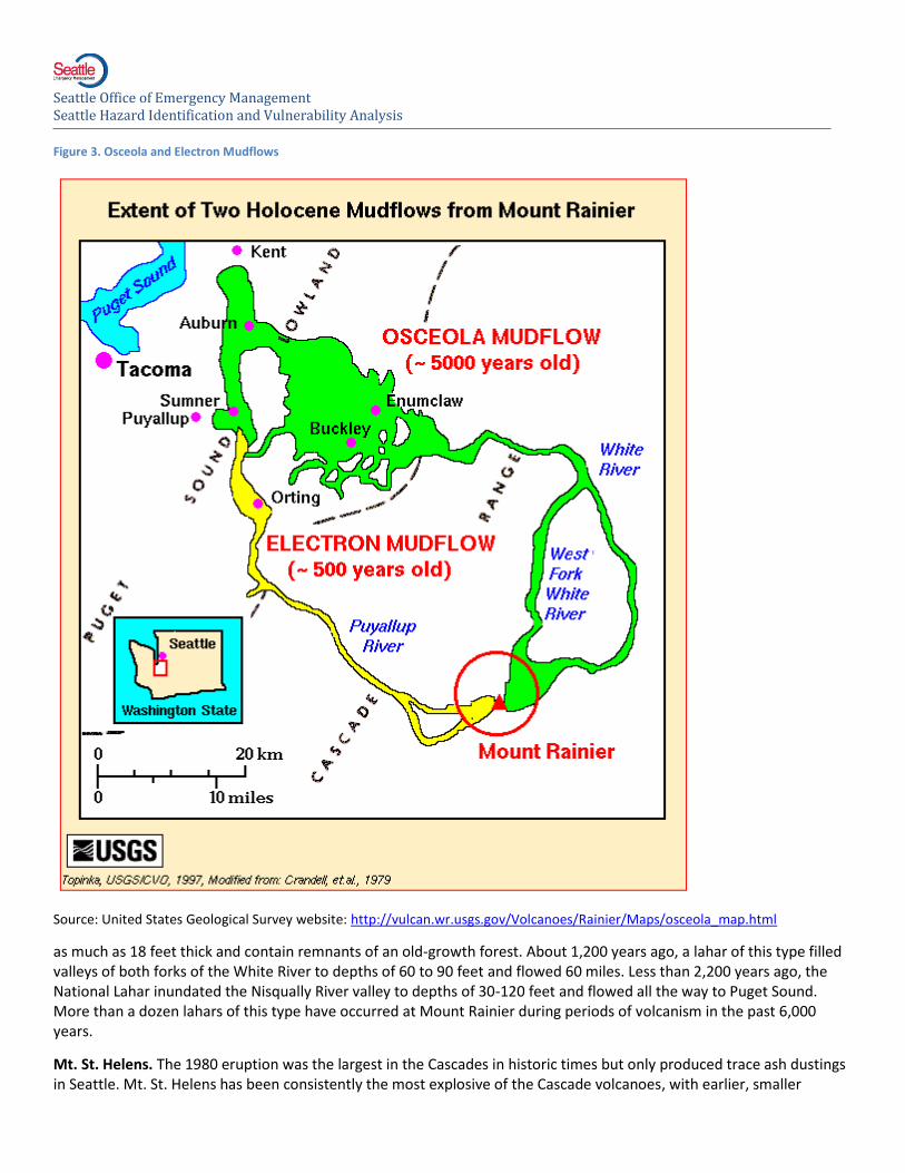
Figure 4. Potential Post-Lahar Sedimentation Area with Key Transportation Infrastructure
Seattle Office of Emergency Management Seattle Hazard Identification and Vulnerability Analysis
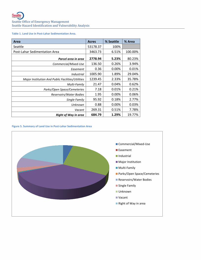
Table 1. Land Use in Post-Lahar Sedimentation Area.
Area Acres % Seattle % Area
Seattle 53178.37 100%
Post-Lahar Sedimentation Area 3463.73 6.51% 100.00%
Parcel area in area 2778.94 5.23% 80.23%
Commercial/Mixed-Use 136.50 0.26% 3.94%
Easement 0.36 0.00% 0.01%
Industrial 1005.90 1.89% 29.04%
Major Institution And Public Facilities/Utilities 1239.45 2.33% 35.78%
Multi-Family 21.47 0.04% 0.62%
Parks/Open Space/Cemeteries 7.18 0.01% 0.21%
Reservoirs/Water Bodies 1.95 0.00% 0.06%
Single Family 95.92 0.18% 2.77%
Unknown 0.88 0.00% 0.03%
Vacant 269.31 0.51% 7.78%
Right of Way in area 684.79 1.29% 19.77%
Figure 5. Summary of Land Use in Post-Lahar Sedimentation Area
Commercial/Mixed-Use
Easement
Industrial
Major Institution
Multi-Family
Parks/Open Space/Cemeteries
Reservoirs/Water Bodies
Single Family
Unknown
Vacant
Right of Way in area
Seattle Office of Emergency Management Seattle Hazard Identification and Vulnerability Analysis
Table 2. Estimated Population, Structures and Assessed Value in Post-Lahar Sedimentation Area
Number of Buildings 2,536 Est. Pop
Number of Single Family Units 847 1745
Number of Multi-Family Units 726 1496
Residential Gross Sq Footage 1,906,099
Commercial Gross Sq Footage 29,047,215
Total Assessed Value $ 4,998,383,962
Estimated Residential Population 3240
Table 3. Critical Facilities in Post-Lahar Sedimentation Area
Medical and Health Services 2
Government Function 0
Protective Function 2
Schools 0
Hazardous Materials Storage Sites 15
Bridges 23
Major Tunnels 0
Water 1
Waste Water 2
Communications 0
Energy 2
Human Services 4
High Population 0
Total 51
Table 4. Facilities with Concentrated Vulnerable Populations in Post-Lahar Sedimentation Area.
Adult Family Homes 0
Boarding House 0
Child Care Centers 3
Nursing Home 0
Intermediate Care Facility 0
Total 3
Seattle Office of Emergency Management Seattle Hazard Identification and Vulnerability Analysis
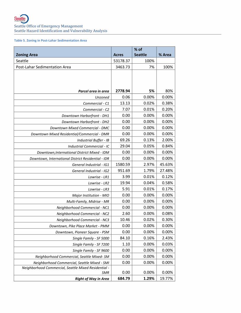
Table 5. Zoning in Post-Lahar Sedimentation Area
Zoning Area Acres % of Seattle % Area
Seattle 53178.37 100%
Post-Lahar Sedimentation Area 3463.73 7% 100%
Parcel area in area 2778.94 5% 80%
Unzoned 0.06 0.00% 0.00%
Commercial - C1 13.13 0.02% 0.38%
Commercial - C2 7.07 0.01% 0.20%
Downtown Harborfront - DH1 0.00 0.00% 0.00%
Downtown Harborfront - DH2 0.00 0.00% 0.00%
Downtown Mixed Commercial - DMC 0.00 0.00% 0.00%
Downtown Mixed Residential/Commercial - DMR 0.00 0.00% 0.00%
Industrial Buffer - IB 69.26 0.13% 2.00%
Industrial Commercial - IC 29.04 0.05% 0.84%
Downtown,International District Mixed - IDM 0.00 0.00% 0.00%
Downtown, International District Residential - IDR 0.00 0.00% 0.00%
General Industrial - IG1 1580.59 2.97% 45.63%
General Industrial - IG2 951.69 1.79% 27.48%
Lowrise - LR1 3.99 0.01% 0.12%
Lowrise - LR2 19.94 0.04% 0.58%
Lowrise - LR3 5.91 0.01% 0.17%
Major Institution - MIO 0.00 0.00% 0.00%
Multi-Family, Midrise - MR 0.00 0.00% 0.00%
Neighborhood Commercial - NC1 0.00 0.00% 0.00%
Neighborhood Commercial - NC2 2.60 0.00% 0.08%
Neighborhood Commercial - NC3 10.46 0.02% 0.30%
Downtown, Pike Place Market - PMM 0.00 0.00% 0.00%
Downtown, Pioneer Square - PSM 0.00 0.00% 0.00%
Single Family - SF 5000 84.10 0.16% 2.43%
Single Family - SF 7200 1.10 0.00% 0.03%
Single Family - SF 9600 0.00 0.00% 0.00%
Neighborhood Commercial, Seattle Mixed- SM 0.00 0.00% 0.00%
Neighborhood Commercial, Seattle Mixed - SMI 0.00 0.00% 0.00% Neighborhood Commercial, Seattle Mixed Residential -
SMR 0.00 0.00% 0.00%
Right of Way in Area 684.79 1.29% 19.77%
Seattle Office of Emergency Management Seattle Hazard Identification and Vulnerability Analysis
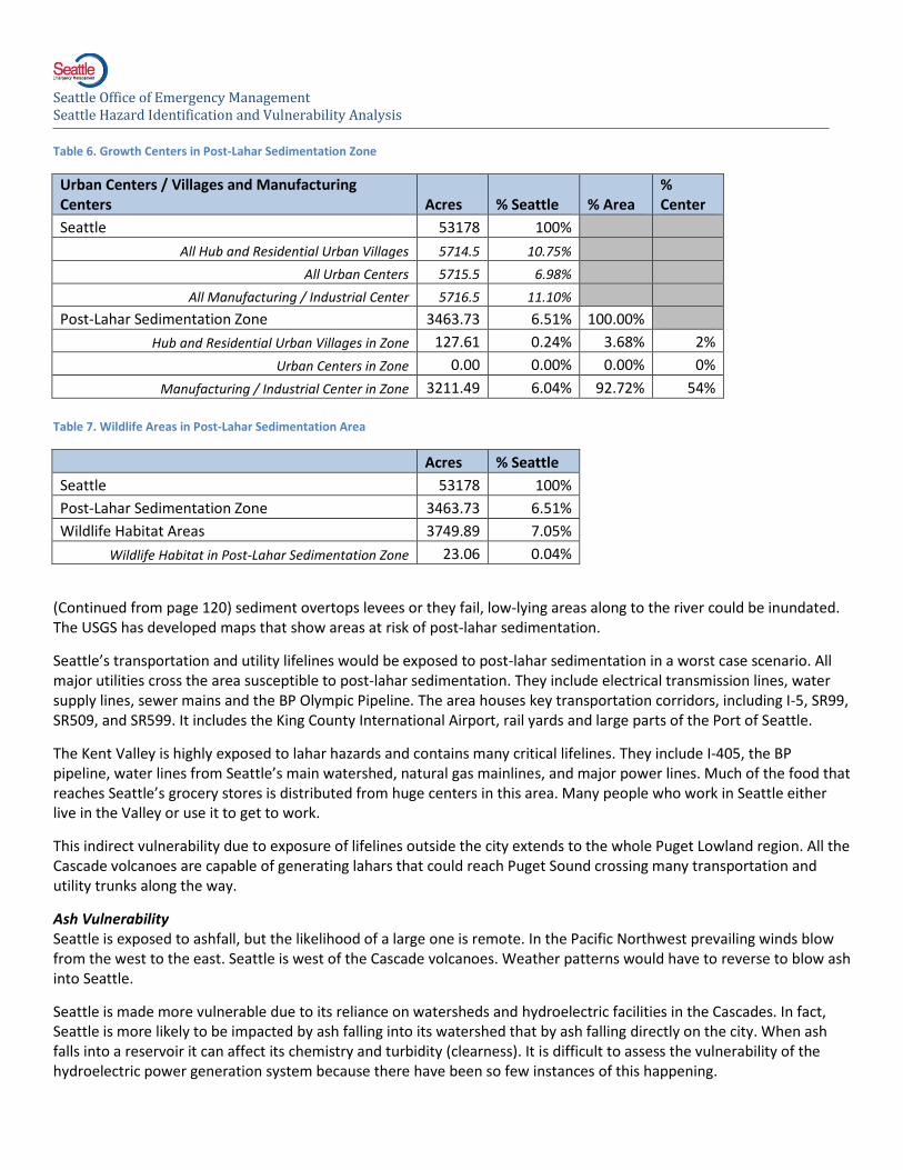
Table 6. Growth Centers in Post-Lahar Sedimentation Zone
Urban Centers / Villages and Manufacturing Centers Acres % Seattle % Area
% Center
Seattle 53178 100%
All Hub and Residential Urban Villages 5714.5 10.75%
All Urban Centers 5715.5 6.98%
All Manufacturing / Industrial Center 5716.5 11.10%
Post-Lahar Sedimentation Zone 3463.73 6.51% 100.00%
Hub and Residential Urban Villages in Zone 127.61 0.24% 3.68% 2%
Urban Centers in Zone 0.00 0.00% 0.00% 0%
Manufacturing / Industrial Center in Zone 3211.49 6.04% 92.72% 54%
Table 7. Wildlife Areas in Post-Lahar Sedimentation Area
Acres % Seattle
Seattle 53178 100%
Post-Lahar Sedimentation Zone 3463.73 6.51%
Wildlife Habitat Areas 3749.89 7.05%
Wildlife Habitat in Post-Lahar Sedimentation Zone 23.06 0.04%
(Continued from page 120) sediment overtops levees or they fail, low-lying areas along to the river could be inundated. The USGS has developed maps that show areas at risk of post-lahar sedimentation.
Seattle’s transportation and utility lifelines would be exposed to post-lahar sedimentation in a worst case scenario. All major utilities cross the area susceptible to post-lahar sedimentation. They include electrical transmission lines, water supply lines, sewer mains and the BP Olympic Pipeline. The area houses key transportation corridors, including I-5, SR99, SR509, and SR599. It includes the King County International Airport, rail yards and large parts of the Port of Seattle.
The Kent Valley is highly exposed to lahar hazards and contains many critical lifelines. They include I-405, the BP pipeline, water lines from Seattle’s main watershed, natural gas mainlines, and major power lines. Much of the food that reaches Seattle’s grocery stores is distributed from huge centers in this area. Many people who work in Seattle either live in the Valley or use it to get to work.
This indirect vulnerability due to exposure of lifelines outside the city extends to the whole Puget Lowland region. All the Cascade volcanoes are capable of generating lahars that could reach Puget Sound crossing many transportation and utility trunks along the way.
Ash Vulnerability Seattle is exposed to ashfall, but the likelihood of a large one is remote. In the Pacific Northwest prevailing winds blow from the west to the east. Seattle is west of the Cascade volcanoes. Weather patterns would have to reverse to blow ash into Seattle.
Seattle is made more vulnerable due to its reliance on watersheds and hydroelectric facilities in the Cascades. In fact, Seattle is more likely to be impacted by ash falling into its watershed that by ash falling directly on the city. When ash falls into a reservoir it can affect its chemistry and turbidity (clearness). It is difficult to assess the vulnerability of the hydroelectric power generation system because there have been so few instances of this happening.
Seattle Office of Emergency Management Seattle Hazard Identification and Vulnerability Analysis
Figure 6. Annual Probability of 1cm Ash Accumulation.
Consequences
Volcanoes pose two hazards to Seattle: ashfall and lahars. Each has its own set of consequences. Seattle is too far from the Cascade volcanoes to be directly affected by blast and pyroclastic flows.
Lahars and Post-Lahar Sedimentation The consequences of a lahar would depend on where it originated and how far it traveled. Mt. Rainier poses the biggest risk because it can generate very large lahars and sits closer to the densest part of the Puget Sound area than the other Cascade volcanoes. In the most likely case, Seattle would have to deal with the effects of a lahar on areas outside Seattle and, in the case of a Mt. Rainier lahar, post-lahar sedimentation in the Duwamish waterway.
In a post-lahar sedimentation event, sediment could wash down the river for years. The consequences would be primarily economic and environmental.
Lahar material from the Kent Valley would introduce more polluted debris into the waterway which is undergoing a cleanup. The increased sediment and dredging operations would set back environmental restoration efforts. Salmon and other wildlife populations in the Duwamish/Green River floodplain could be devastated if their habitat is dramatically altered.
If sediments accumulated, economic activity in Seattle could be affected. Even a short closure could be costly. Portland lost $13,000,000 (2009 dollars) when its port closed after the 1980 Mt. St. Helens eruptionxi.
Sedimentation could possibly alter the course several rivers, including the White River which joins the Puyallup River as it flows to Tacoma. A large lahar could alter the White River’s course and link it with the Green River instead of the Puyallup River. This would cause increase water volume and sediment to Seattle.
If sediments breach the levees, the consequences grow more severe. Property, lifelines and critical facilities would be affected. The property exposed to the lahar hazard is predominantly commercial and industrial but includes residential areas and the King County International Airport. The area is heavily used by the Port of Seattle, Boeing and commodity distribution centers. The Georgetown and South Park residential communities are in the same area. Given the time
Source: United States Geological Survey website: http://vulcan.wr.usgs.gov/Volcanoes/Newberry/Hazards/OFR97-513/OFR97-513_inlined.html
Seattle Office of Emergency Management Seattle Hazard Identification and Vulnerability Analysis
sensitivity of many port freight operations and very competitive margins, prolonged outages could have severe economic effects.
If the valley floor is inundated, several vital transportation routes, SR-99 and I-5 could be blocked. Most of Seattle’s rail lines, including major railyards occupy this area. These yards include the Union Pacific yard where Seattle’s garbage is loaded daily onto trains bound for landfills in Oregon.
If a lahar were to reach Seattle there could be high loss of life. Transportation, utilities and economic activity would suffer long-lasting damage due to infrastructure damage. The Duwamish Valley and all the other valleys leading up to Mt. Rainier would be buried under mud ranging from a few feet thick near the end of the lahar to hundreds of feet thick closer to Mt. Rainier.
Roughly 3,300 people live in the Post-Lahar Sedimentation Area, mostly in the Georgetown and South Park areas. The precise day time population is unknown, but it is a major employment area. They are exposed to danger only from a lahar reaching Seattle, not from post-lahar sedimentation.
Ash Prevailing winds blow toward the east, making tephra or ash much more likely to fall in eastern Washington than in Seattle. City owned resources in the Cascades and eastern Washington are more likely to receive ashfall than the city itself.
The smaller the amount ash, the more likely it is to occur. Seattle received a trace amount of ash from the 1980 Mt. St. Helens eruption and would likely receive trace amounts in a future eruption. These dustings do not create emergencies.
The experiences of Yakima and Spokane in 1980 reveal a “typical” case of an ash fall emergency. Yakima received about 3 inches; Spokane got 2 inches. Both communities were shut down for days. The ash falls caused a “midnight at noon” effect in Eastern Washington that lasted for 18 hours. While both cities are well prepared for snowstorms, both were overwhelmed by the ash. Seattle would likely be severely affected by less ash than these cities received.
An ashfall would have five potentially large impacts:
Ash would irritate people’s eyes and throats, especially those with existing respiratory trouble, but it would rarely cause deathxii. Many people had to wear masks in Eastern Washington or stay inside while the ash fell. The same could happen in Seattle. Blowing ash could prolong these problems, especially if the ash is very fine.
Traffic would stop if ash covered the roads. Many people would be stuck and accidents would probably increase. Although the timeframe of an eruption could generally be predicted, an actual eruption could catch many people on the roads, making it worse that a snowstorm.
Vehicles and other machines would break down as the ash clogged their moving parts. This would compound traffic and clean-up problems.
Ash could disrupt the city’s utilities. Waste water systems are especially vulnerable to ash, especially if sewage and stormwater are collected in one network as they are in parts of Seattle. In reservoirs, it would increase turbidity, making the water undrinkable until it settled. It could also damage power generation facilities prompting expensive emergency power purchasesxiii. Wireless communications and public safety would be impeded.
The city would incur huge clean-up costs. Yakima, a city much smaller than Seattle, had to pay at least $1.1 million to get the ash off the streetsxiv. These problems would be worse if it were to combine with water and fall from the sky as mud. The weight could lead to roof collapses throughout the city.
A heavier ash fall would cause more severe versions of problems expected by the more “typical” scenario. If the ash is acidic or acidic rain falls, injuries and damage would increase. One Alaskan volcano produced acidic ash that burned victims’ eyes, throats and lips, making eating difficult. Other acidic rains burned the skin. Acidic rains have also destroyed clothing and corroded metal. These alarming effects are rare and did not occur during the 1980 Mt. St. Helens eruption.
Seattle Office of Emergency Management Seattle Hazard Identification and Vulnerability Analysis
Volcanic ash damages human health, buildings, communication equipment, power, transportation system, water supplies and drainage infrastructure. Seattle is the densest collection of people, buildings, and infrastructure in the Pacific Northwest and is naturally more exposed than less dense areas.
The costs of a heavy ash fall would include the halting of economic activity for several days or weeks, property damage, and cleanup costs. Since an ash fall would affect the whole Puget Sound region, Seattle could not rely on aid from neighboring governments. A mudflow would increase the damage and probably stop port activity for several weeks. Aviation would be disrupted. Seattle could be economically impacted even if not physically damaged.
Most Likely Scenario A Mt. Rainier lahar devastates the Puyallup, Carbon and White River valleys stopping at Auburn. In the next few weeks massive amounts of debris begin flushing out the Duwamish blocking the waterway and overflowing the banks of the river in South Park and Georgetown. Major distribution and transportation hubs south of the City are destroyed causing localized food shortages. People who work in Seattle and live in South King County and Pierce County have a hard time commuting to work.
Category Impacts 1 = low 5 = high
Narrative
Frequency
2
The type of lahar envisioned in this scenario is a ‘Case I’ flow as categorized by the Cascades Volcano Observatory. Case I lahars are estimated to happen about once every 500 to 1000 years.
Geographic Scope 2
The only affected area in Seattle itself is the Duwamish Waterway, but the Kent Valley south of Seattle will be severely impacted.
Duration
5
Lahar deposits wash down the Duwamish River for weeks. The regional transportation system will be disrupted for weeks. Many people who live South King County but work in Seattle are displaced. Seattle residents who work in South King County lose their work places.
Health Effects, Deaths and Injuries 1 The incident causes no deaths or injuries in Seattle.
Displaced Households and Suffering 4
200 households in Southpark and Georgetown are displaced and Seattle hosts many people who are displaced from South King County.
Economy
3
The Duwamish waterway must be dredged. This work impacts Port of Seattle and other shipping operations. Transportation routes and distribution centers south of the City are severely impacted. Workers living south of Seattle have longer commutes.
Environment
2
The lahar debris causes extension damage in the Green River and Duwamish waterway as extensive efforts are underway to restore it. The lahar sediments contain hazardous materials from destroyed buildings upstream.
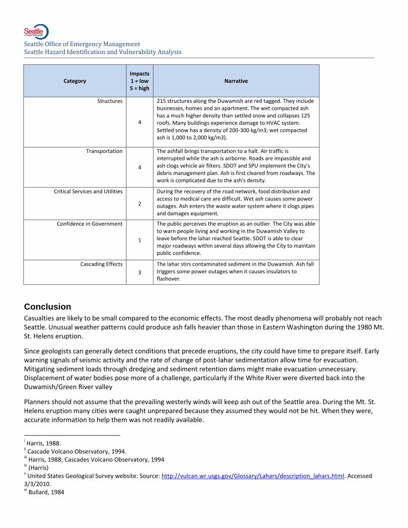
Structures 3
100 structures along the Duwamish waterway are damaged. The lahar debris moves slowly and floods buildings with heavy sludge.
Transportation
2
Transportation routes in Seattle itself on not affected, but those to the south are severely impacted. Bridges, highways and rail lines are heavily damaged.
Critical Services and Utilities
3
The lahar from Mt. Rainier has heavily damaged multiple warehouses and distribution centers in the Kent Valley including food distribution centers. Seattle suffers several days of food and commodity shortages as business adjust.
Seattle Office of Emergency Management Seattle Hazard Identification and Vulnerability Analysis
Category Impacts 1 = low 5 = high
Narrative
Frequency
2
The type of lahar envisioned in this scenario is a ‘Case I’ flow as categorized by the Cascades Volcano Observatory. Case I lahars are estimated to happen about once every 500 to 1000 years.
Confidence in Government
1
The Seattle public is not directly impacted by the eruption and views it as a natural event. It does not hold the City of Seattle responsible for it.
Cascading Effects 1
The post-lahar sedimentation will not be likely to cause secondary hazards, but will complicate the Duwamish restoration.
Maximum Credible Scenarios Mt. Rainier erupts. Despite lack of known precedent, a lahar reaches Seattle. The city has several hours of warning. At the same time, an unusual weather pattern blows 6" ash into Seattle. Rain moves in after the ash fall. The ash becomes hard and cement like as it gets wet.
Category Impacts 1 = low 5 = high
Narrative
Frequency
1
This scenario would be an unprecedented event. No evidence has been found that a lahar has reached the mouth of the Duwamish. The Cascade Volcano Observatory estimates them as a less than 1 in 1000 year events. (Chang, 2007). Only one ash deposit has been found in Seattle and it was far less than 6".
Geographic Scope
5
The entire Central Puget Sound region would be affected by this event. Ash would blanket the region and the Green River Valley would be covered by a lahar.
Duration
5
Response and short term recovery take 4 weeks. Long term recovery will take years. Even with a debris management plan, tapping resources to remove large amounts of ash is difficult. The lahar has also generated large amounts of debris and caused much structural damage which takes time to repair.
Health Effects, Deaths and Injuries 1
Despite the heavy physical damage, the incident causes no casualties due to timely warning provided by the USGS.
Displaced Households and Suffering 2
89 people require shelter because their homes and apartments have been red tagged due to lahar damage.
Economy
3
The ashfall interrupts commerce until it can be cleared, but the biggest stressor for the economy is the lahar which has caused extensive damage along the Duwamish waterway. The shipping and manufacturing sectors are the most heavily affected.
Environment
2
The lahar scours the Duwamish Waterway setting back restoration efforts. Ash has a short term detrimental effect on plants, but will enrich the soil long term.
Seattle Office of Emergency Management Seattle Hazard Identification and Vulnerability Analysis
Category Impacts 1 = low 5 = high
Narrative
Structures
4
215 structures along the Duwamish are red tagged. They include businesses, homes and an apartment. The wet compacted ash has a much higher density than settled snow and collapses 125 roofs. Many buildings experience damage to HVAC system. Settled snow has a density of 200-300 kg/m3; wet compacted ash is 1,000 to 2,000 kg/m3).
Transportation
4
The ashfall brings transportation to a halt. Air traffic is interrupted while the ash is airborne. Roads are impassible and ash clogs vehicle air filters. SDOT and SPU implement the City's debris management plan. Ash is first cleared from roadways. The work is complicated due to the ash's density.
Critical Services and Utilities
2
During the recovery of the road network, food distribution and access to medical care are difficult. Wet ash causes some power outages. Ash enters the waste water system where it clogs pipes and damages equipment.
Confidence in Government
1
The public perceives the eruption as an outlier. The City was able to warn people living and working in the Duwamish Valley to leave before the lahar reached Seattle. SDOT is able to clear major roadways within several days allowing the City to maintain public confidence.
Cascading Effects
3
The lahar stirs contaminated sediment in the Duwamish. Ash fall triggers some power outages when it causes insulators to flashover.
Conclusion
Casualties are likely to be small compared to the economic effects. The most deadly phenomena will probably not reach Seattle. Unusual weather patterns could produce ash falls heavier than those in Eastern Washington during the 1980 Mt. St. Helens eruption.
Since geologists can generally detect conditions that precede eruptions, the city could have time to prepare itself. Early warning signals of seismic activity and the rate of change of post-lahar sedimentation allow time for evacuation. Mitigating sediment loads through dredging and sediment retention dams might make evacuation unnecessary. Displacement of water bodies pose more of a challenge, particularly if the White River were diverted back into the Duwamish/Green River valley
Planners should not assume that the prevailing westerly winds will keep ash out of the Seattle area. During the Mt. St. Helens eruption many cities were caught unprepared because they assumed they would not be hit. When they were, accurate information to help them was not readily available.
i Harris, 1988. ii Cascade Volcano Observatory, 1994.
iii Harris, 1988; Cascades Volcano Observatory, 1994
iv (Harris)
v United States Geological Survey website: Source: http://vulcan.wr.usgs.gov/Glossary/Lahars/description_lahars.html. Accessed
3/3/2010. vi Bullard, 1984
Seattle Office of Emergency Management Seattle Hazard Identification and Vulnerability Analysis
vii
Bullard, 1984 viii
Bullard, 1984 ix Bullard, 1984; Scarth, 1994; Cascades Volcano Observatory, 1994
x Harris, 1988; Bullard, 1984
xi Harris, 1988
xii Blong, 1984
xiii Blong, 1984
xiv Blong, 1984