
Visit activities.carsondellosa.com for FREE...
14
Transcript of Visit activities.carsondellosa.com for FREE...
5–8
Visit activities.carsondellosa.com for FREE activities!
Go to
5–85–8
activities.carsondellosa.com for FREE activities!
Exploring Antarctica introduces students to the geography, history, and exploration of the continent of Antarctica. The Close-Up reading selections provide students with facts and information. The Knowledge Checks assess student understanding of the reading using selected response and constructed response questioning strategies. Map Follow-Ups provide opportunities for students to report information from a spatial perspective and develop their map skills. Explore sections allow students to expand learning by participating in high interest, hands-on activities. Vocabulary words are boldfaced in the text and de�ned in a glossary at the back of the book. Topics covered include climate, ice forms, plant and animal life, exploration, conservation, and scienti�c research on the continent. An alternative version of the reading selections at a lower reading level is available for download at www.carsondellosa.com. For correlations to national, state, and provincial standards, also visit www.carsondellosa.com.
Printed in the USA

Exploring Antarctica
ii404171-EB ©Mark Twain Media, Inc., Publishers
Table of Contents
Table of Contents
Introduction to the Teacher .......................... 1
The Continents Close-Up ................................................... 2 Knowledge Check ..................................... 4 Map Follow-Up .......................................... 5 Explore ...................................................... 6
The Continent of Antarctica Close-Up ................................................... 7 Outline Map of Antarctica .......................... 8 Knowledge Check ..................................... 9 Map Follow-Up ........................................ 10 Map Follow-Up ........................................ 11 Explore .................................................... 12
Antarctica’s Climate Close-Up ................................................. 13 Knowledge Check ................................... 14
Antarctica’s Ice Close-Up ................................................. 15 Knowledge Check ................................... 16 Map Follow-Up ........................................ 17 Explore .................................................... 18
Antarctica’s Plant and Animal Life Close-Up ................................................. 19 Knowledge Check ................................... 20 Explore .................................................... 21
Early Exploration of Antarctica Close-Up ................................................. 22 Knowledge Check ................................... 23 Explore .................................................... 24
The Race to the South Pole Close-Up ................................................. 25 Knowledge Check ................................... 26 Ernest Shackleton Close-Up ................................................. 27 Knowledge Check ................................... 28 Explore .................................................... 29
Later Exploration of Antarctica Close-Up ................................................. 30 Knowledge Check ................................... 31 Explore .................................................... 32
Antarctica’s Conservation Close-Up ................................................. 33 Knowledge Check ................................... 34 Explore .................................................... 35
Scientific Research Close-Up ................................................. 36 Knowledge Check ................................... 38
Governing Antarctica Close-Up ................................................. 39 Knowledge Check ................................... 40 Map of National Claims to Antarctica ....... 41
Glossary ...................................................... 42
Answer Keys ............................................... 44
Bibliography ................................................ 46
Photo Credits ..............................................C3

Exploring Antarctica
1404171-EB ©Mark Twain Media, Inc., Publishers
Introduction to the Teacher
Exploring Antarctica is one of the seven books in Mark Twain Media’s Continents of the World Geography Series. The books are a valuable resource for any classroom. The series can be used to supplement the middle-school geography and social studies curriculum. The bookssupport the goal of the National Geography Standards to prepare students for life in a global community by strengthening geographical literacy.
The intent of the Continents of the World Geography Series is to help students better understand the world around them through the study of geography. Each book focuses on one continent. Information and facts are presented in an easy-to-read and easy-to-understand format that does not overwhelm the learner. The text presents only the most important information in small, organized bites to make it easier for students to comprehend. Vocabulary words are boldfaced in the text. For quick reference, these words are listed in a glossary at the back of the book.
The series is specifically designed to facilitate planning for the diverse learning styles and skill levels of middle-school students. Each book is divided into several units. Each unit provides the teacher with alternative methods of instruction.
Unit Features • Close-Up introduces facts and information as a reading exercise. • Knowledge Check assesses student understanding of the reading exercise using
selected response and constructed response questioning strategies. • Map Follow-Up provides opportunities for students to report information from a spatial
perspective. • Explore allows students to expand learning by participating in high-interest, hands-on
activities. • Glossary lists the boldfaced words with definitions.
Online Resources• Reluctant Reader Text: A modified version of the reading exercise pages can be
downloaded from www.carsondellosa.com. In the Search box, enter the produce code CD-404171. When you reach the Exploring Antarctica product page, click the icon for the Reluctant Reader Text download.
• The readability level of the text has been modified to facilitate struggling readers. The Flesch-Kincaid Readability formula, which is built into Microsoft Word™, was used to determine the readability level. The formula calculates the number of words, sentences, and paragraphs in each selection to produce a reading level.
Additional Resources Classroom Decoratives: The Seven Continents of the World and World Landmarks and Locales Topper bulletin board sets are available through Mark Twain Media/Carson-Dellosa Publishing LLC. These classroom decoratives visually reinforce geography lessons found in the Continents of the World Geography Series in an interesting and attention-grabbing way.
Introduction to the Teacher

Exploring Antarctica
2404171-EB ©Mark Twain Media, Inc., Publishers
The Continents: Close-Up
A continent is a large landmass completely or mostly surrounded by water. The continents make up just over 29 percent of the earth’s surface. They occupy about 57,100,000 square miles (148,000,000 sq. km). More than 65 percent of the land area is in the Northern Hemisphere.
Landmasses • Continents: Geographers list
North America, South America, Europe, Asia, Africa, Australia, and Antarctica as continents.
• Subcontinents: Greenland and the India-Pakistan area are sometimes referred to as “subcontinents.”
• Microcontinents: Madagascar and the Seychelles Islands are often called “microconti-nents.”
• Oceania: The island groups in the Pacific Ocean are called Oceania, but they are not considered a continent.
How Were the Continents Formed? For many years, Europeans believed the continents were formed by a catastrophe or series of catastrophes, such as floods, earthquakes, and volcanoes. In 1596, a Dutch mapmaker, Abraham Ortelius, noted that the Americas’ eastern coasts and the western coasts of Europe and Africa looked as if they fit together. He proposed that once they had been joined but later were torn apart.
Many years later, a German named Alfred Lothar Wegener published a book in which he explained his theory of the “Continental Drift.” Wegener, like Ortelius, believed that the earth originally had one supercontinent. He named it Pangaea from the Greek word meaning “all lands.” He believed that the large landmass was a lighter rock that floated on a heavier rock, like ice floats on water.
Wegener’s theory stated that the land-masses were still moving at a rate of about one yard each century. Wegener believed that Pangaea existed in the Permian Age. Then Pangaea slowly divided into two continents,
Wegener’s theoretical continent, Pangaea, during the Permian Age (white outlines indicate current continents)
The Continents TodayThe Continents Today
NorthAmerica
SouthAmerica
Antarctica
Africa
EuropeAsia
Australia
The Continents: Close-Up

Exploring Antarctica
3404171-EB ©Mark Twain Media, Inc., Publishers
The earth’s crust consists of about 20 plates. Plate tectonics suggest that these plates move a few inches each year.
Landmasses during the Jurassic Age
The earth’s crust consists of about 20 plates. Plate tectonics suggest that these plates move a few inches
North AmericanPlate
EurasianPlate
AfricanPlate
Arabian Plate
Indo-AustralianPlate
South American
Plate
Antarctic PlateScotia Plate
Cocos Plate
NazcaPlate
PacificPlate
PacificPlate
CaribbeanPlate
PhilippinePlate
the upper part, Laurasia, and the lower, Gondwanaland, during the Triassic Age.
By the Jurassic Age, the landmass-es had moved into what we could recog-nize as the seven continents, although they were still located near each other. Eventu-ally, the continents “drifted” to their present locations.
Most scientists had been in agree-ment on the continental drift theory until re-searchers in the 1960s discovered several major mountain ranges on the ocean floor. These mountains suggested that the earth’s crust consists of about 20 slabs or plates.
These discoveries led to a new theory, “Plate Tectonics,” which has become more popular. This theory suggests that these plates move a few inches each year. In some places the plates are moving apart, while in others, the plates are colliding or scraping against each other.
Scientists also discovered that most volcanoes and earthquakes occur along the boundar-ies of the various plates. Recent earthquakes near Indonesia and Japan along the boundaries of the Indo-Australian, Eurasian, Philippine, and Pacific Plates have triggered devastating tsunamis that killed hundreds of thousands of people. Scientists hope that further study will help them in-crease their understanding of Earth’s story.
The Continents: Close-Up

Exploring Antarctica
4404171-EB ©Mark Twain Media, Inc., Publishers
Name: Date:
Matching
1. Plate Tectonics a. lower part of Pangaea
2. Laurasia b. Greek word meaning “all lands”
3. continent c. theory suggesting that plates move a few inches each
4. Gondwanaland year
5. Pangaea d. upper part of Pangaea
e. a large landmass completely or mostly surrounded by
water
Knowledge Check
Multiple Choice
6. He explained his theory of the Continental Drift.
a. Abraham Ortelius b. Alfred Lothar Wegener c. Pangaea d. Laurasia
7. The earth’s crust consists of plates.
a. about 20 b. about 10 c. about 5 d. about 50
Did You Know?
Earth is thought to be the onlyplanet in our solar system that has plate tectonics.
Constructed ResponseExplain how the movement of the earth’s plates formed the seven continents. Use two details from the selection to support your answer.
The Continents: Knowledge Check
Exploring Antarctica
5404171-EB ©Mark Twain Media, Inc., Publishers
Name: Date:
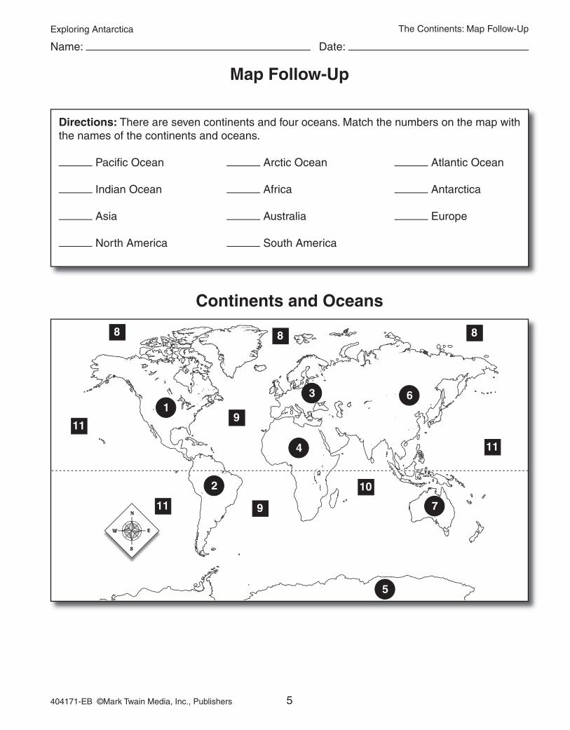
Map Follow-Up
Directions: There are seven continents and four oceans. Match the numbers on the map with the names of the continents and oceans.
Pacific Ocean Arctic Ocean Atlantic Ocean
Indian Ocean Africa Antarctica
Asia Australia Europe
North America South America
4
5
6
7
31
2
88 8
9
9
10
11
11
11
Continents and Oceans
The Continents: Map Follow-Up

Exploring Antarctica
6404171-EB ©Mark Twain Media, Inc., Publishers
Name: Date:
Explore: Antarctica Tortilla Map
The Continents: Explore
Materialsblue construction paper (9” X 12”) pencil tortilla 8” size black and red markers (fine point) scissors flour outline map of Antarctica glue salt water atlas mixing bowl white chalk plastic baggie
Directions
Day 1Step 1: Mix 1⁄2 cup flour with 1⁄4 cup salt and 1⁄4 cup of water in mixing bowl to form a model-
ing dough.Step 2: Place dough in plastic baggie and set aside.Step 3: Cut Antarctica from outline map.Step 4: Trace and cut the outline from the tortilla. Do not discard the scraps, they can be used
for other landforms.Step 5: Use the scraps to cut rough shapes of the southernmost parts of South America,
South Africa, Australia, and New Zealand. Then cut out islands for Madagascar, Tas-mania, and the Falkland Islands.
Step 6: Place the cutouts on the blue construction paper. Refer to a map from the atlas to posi-tion the landforms correctly.
Step 7: Glue the cutouts on the construction paper.Step 8: Mold the dough on the tortilla cutouts to create mountain ranges for the Transantarctic
Mountains, Ellsworth Range, and Andes in South America. Let dry overnight.
Day 2Step 1: Color in the ice shelf with white chalk.Step 2: Label landforms, major oceans and seas,
and mountain ranges with black marker.Step 3: Draw in the Antarctic Circle with the red
marker and label it 66° South.
Exploring Antarctica
7404171-EB ©Mark Twain Media, Inc., Publishers
The Continent of Antarctica: Close-Up
The Continent of Antarctica: Close-Up
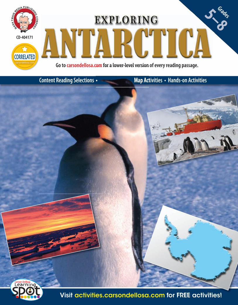
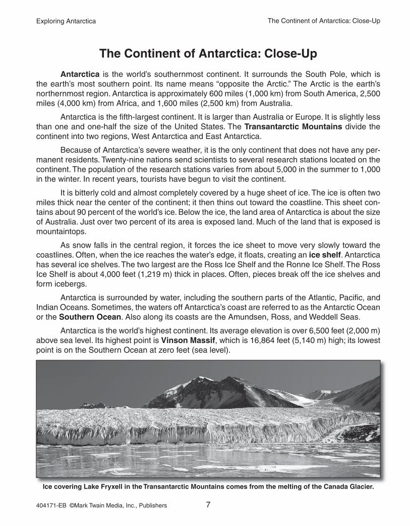
Antarctica is the world’s southernmost continent. It surrounds the South Pole, which is the earth’s most southern point. Its name means “opposite the Arctic.” The Arctic is the earth’s northernmost region. Antarctica is approximately 600 miles (1,000 km) from South America, 2,500 miles (4,000 km) from Africa, and 1,600 miles (2,500 km) from Australia.
Antarctica is the fifth-largest continent. It is larger than Australia or Europe. It is slightly less than one and one-half the size of the United States. The Transantarctic Mountains divide the continent into two regions, West Antarctica and East Antarctica.
Because of Antarctica’s severe weather, it is the only continent that does not have any per-manent residents. Twenty-nine nations send scientists to several research stations located on the continent. The population of the research stations varies from about 5,000 in the summer to 1,000 in the winter. In recent years, tourists have begun to visit the continent.
It is bitterly cold and almost completely covered by a huge sheet of ice. The ice is often two miles thick near the center of the continent; it then thins out toward the coastline. This sheet con-tains about 90 percent of the world’s ice. Below the ice, the land area of Antarctica is about the size of Australia. Just over two percent of its area is exposed land. Much of the land that is exposed is mountaintops.
As snow falls in the central region, it forces the ice sheet to move very slowly toward the coastlines. Often, when the ice reaches the water’s edge, it floats, creating an ice shelf. Antarctica has several ice shelves. The two largest are the Ross Ice Shelf and the Ronne Ice Shelf. The Ross Ice Shelf is about 4,000 feet (1,219 m) thick in places. Often, pieces break off the ice shelves and form icebergs.
Antarctica is surrounded by water, including the southern parts of the Atlantic, Pacific, and Indian Oceans. Sometimes, the waters off Antarctica’s coast are referred to as the Antarctic Ocean or the Southern Ocean. Also along its coasts are the Amundsen, Ross, and Weddell Seas.
Antarctica is the world’s highest continent. Its average elevation is over 6,500 feet (2,000 m) above sea level. Its highest point is Vinson Massif, which is 16,864 feet (5,140 m) high; its lowest point is on the Southern Ocean at zero feet (sea level).
Ice covering Lake Fryxell in the Transantarctic Mountains comes from the melting of the Canada Glacier.

Exploring Antarctica
8404171-EB ©Mark Twain Media, Inc., Publishers
Name: Date:
Outline Map of Antarctica
The Continent of Antarctica: Outline Map of Antarctica
Black outlines indicate coastline covered by ice shelves.
Western Hemisphere
Eastern Hemisphere

Exploring Antarctica
9404171-EB ©Mark Twain Media, Inc., Publishers
Name: Date:
Knowledge Check
The Continent of Antarctica: Knowledge Check
Matching
1. Antarctica a. ice reaching the water’s edge and floating
2. ice shelf creates this
3. Transantarctic Mountains b. the waters off Antarctica’s coast are sometimes
4. Southern Ocean called this
5. Vinson Massif c. “opposite the Arctic”
d. Antarctica’s highest point
e. divides Antarctica into two regions
Multiple Choice
6. Which continent is closest to Antarctica?
a. North America b. South America c. Africa d. Australia
7. What is the population of Antarctica in the summer?
a. about 10,000 b. about 50 c. about 5,000 d. about 100
Did You Know?
Scientists recorded the world’s coldest temperature, 128.6 degrees below zero (Fahrenheit), in Antarctica.
Constructed ResponseExplain the difference between an ice shelf and an iceberg. Use details from the selection to support your answer.
temperature,
below

Exploring Antarctica
10404171-EB ©Mark Twain Media, Inc., Publishers
Name: Date:
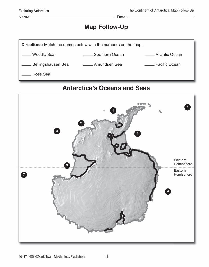
Map Follow-Up
Features of Antarctica
The Continent of Antarctica: Map Follow-Up
Directions: Match the names below with the numbers on the map. Draw the mountain symbol on the map to indicate the location of the Transantarctic Mountains. Label the mountains.
Antarctic Peninsula Ronne Ice Shelf
Eastern Antarctica Ross Ice Shelf
Western Antarctica South Pole
1
2
4
6
Western Hemisphere
Eastern Hemisphere
35
Exploring Antarctica
11404171-EB ©Mark Twain Media, Inc., Publishers
Name: Date:
Map Follow-Up
Antarctica’s Oceans and Seas
The Continent of Antarctica: Map Follow-Up
Directions: Match the names below with the numbers on the map.
Weddle Sea Southern Ocean Atlantic Ocean
Bellingshausen Sea Amundsen Sea Pacific Ocean
Ross Sea
1
2
4
5
4
6
7
Western Hemisphere
Eastern Hemisphere
3

Exploring Antarctica
44404171-EB ©Mark Twain Media, Inc., Publishers
Answer Keys
Answer Keys
The ContinentsKnowledge Check (p. 4)Matching
1. c 2. d 3. e 4. a 5. bMultiple Choice
6. b 7. aConstructed ResponseThe earth’s crust consists of 20 plates. Plate tectonics suggest that these plates move a few inches each year. Over time the plates have moved to their present positions.Map Follow Up (p. 5)
1. North America 2. South America3. Europe 4. Africa5. Antarctica 6. Asia7. Australia 8. Arctic Ocean 9. Atlantic Ocean 10. Indian Ocean
11. Pacific Ocean The Continent of Antarctica Knowledge Check (p. 9)Matching1. c 2. a 3. e 4. b 5. dMultiple Choice6. b 7. cConstructed ResponseAn iceberg is smaller than an ice shelf. An iceberg is a floating piece of ice that is not connected to anything else. An ice shelf is still attached to land. Actually, the ice that breaks off the ice shelf is considered an iceberg.Map Follow Up (p. 10)
1. Antarctic Peninsula 2. Western Antarctica3. South Pole 4. Eastern Antarctica5. Ross Ice Shelf 6. Ronne Ice Shelf
Map Follow (p. 11)1. Weddle Sea 2. Amundsen Sea 3. Ross Sea 4. Southern Ocean5. Bellingshausen Sea 6. Atlantic Ocean7. Pacific Ocean
Antarctica’s ClimateKnowledge Check (p. 14)Matching
1. a 2. e 3. d 4. b 5. cMultiple Choice
6. a 7. dConstructed ResponseThe ozone layer protects the earth from harmful ultraviolet radiation. Scientists fear that the additional radiation will change Antarctica’s ecological system and may affect the food chain of the continent’s fish and other marine life.
Antarctica’s Ice Knowledge Check (p. 16)Matching 1. c 2. e 3. a 4. b 5. dMultiple Choice 6. b 7. cConstructed ResponseThe Lambert Glacier is the largest glacier. It is 248 miles long. The Shirase is the fastest-moving glacier. It travels just over one mile per year.Map Follow Up (p. 17) 1. Antarctic Peninsula 2. Larsen Ice Shelf 3. Ronne-Filchner Ice Shelf 4. Ross Ice Shelf 5. West Ice Shelf 6. Amery Ice Shelf
Antarctica’s Plant and Animal LifeKnowledge Check (p. 20)Matching 1. d 2. e 3. b 4. a 5. cMultiple Choice 6. b 7. cConstructed ResponseKrill is important in the diet of the rest of the animal life in the region. Antarctica’s fish, birds, seals, and whales allfeed on krill. It is often considered to be Antarctica’s major resource to the rest of the world.
Early Exploration of AntarcticaKnowledge Check (p. 23)Matching 1. d 2. c 3. a 4. e 5. bMultiple Choice 6. d 7. bConstructed ResponseAristotle and Ptolemy both believed that there was a huge unknown land in the Southern Hemisphere. Aris-totle named it Antarktikos, and Ptolemy named it Terra Australis Incognita.
The Race to the South Pole Knowledge Check (p. 26)Matching 1. e 2. c 3. a 4. b 5. dMultiple Choice 6. a 7. aConstructed ResponseAnswers will vary. More than likely, Amunden wished him the best of luck based on the letter he left for him.


