Go to DBSTPOEFMMPTB DPN GPS B MPXFS MFWFM...
15
Transcript of Go to DBSTPOEFMMPTB DPN GPS B MPXFS MFWFM...

5–8
Visit activities.carsondellosa.com for FREE activities!
Go to
activities.carsondellosa.com for FREE activities!
Exploring Asia introduces students to the geography, history, and culture of the continent of Asia. The Close-Up reading selections provide students with facts and information. The Knowledge Checks assess student understanding of the reading using selected response and constructed response questioning strategies. Map Follow-Ups provide opportunities for students to report information from a spatial perspective and develop their map skills. Explore sections allow students to expand learning by participating in high interest, hands-on activities. Vocabulary words are boldfaced in the text and de�ned in a glossary at the back of the book. Topics covered include climate, resources, industries, people, animals, culture, and pro�les of selected nations from throughout the continent. An alternative version of the reading selections at a lower reading level is available for download at www.carsondellosa.com. For correlations to national, state, and provincial standards, also visit www.carsondellosa.com.
Printed in the USA

Exploring Asia
ii404172-EB ©Mark Twain Media, Inc., Publishers
Table of Contents
Table of Contents
Introduction to the Teacher .......................... 1
The Continents Close-Up ................................................... 2 Knowledge Check ..................................... 4 Map Follow-Up .......................................... 5 Explore ...................................................... 6
The Continent of Asia Close-Up ................................................... 7 Outline Map of Asia ................................... 8 Knowledge Check ..................................... 9 Map Follow-Up ........................................ 10 Map Follow-Up ........................................ 11 Explore .................................................... 12
Asia’s Climate Close-Up ................................................. 13 Knowledge Check ................................... 14 Map Follow-Up ........................................ 15
Asia’s Resources Close-Up ................................................. 16 Knowledge Check ................................... 17 Map Follow-Up ........................................ 18
Asia’s Industries Close-Up ................................................. 19 Knowledge Check ................................... 20 Map Follow-Up ........................................ 21 Asia’s Animal Life Close-Up ................................................. 22 Knowledge Check ................................... 23 Explore .................................................... 24
The People of Asia Close-Up ................................................. 25 Knowledge Check ................................... 26 Asian Culture Close-Up ................................................. 27 Knowledge Check ................................... 28
Nations of Southeast Asia Close-Up ................................................. 29 Knowledge Check ................................... 30 Map Follow-Up ........................................ 31
Nations of Southwest Asia Close-Up ................................................. 32 Knowledge Check ................................... 33 Map Follow-Up ........................................ 34
Nations of South and Russian Asia Close-Up ................................................. 35 Knowledge Check ................................... 37 Map Follow-Up ........................................ 38
Nations of East Asia Close-Up ................................................. 39 Knowledge Check ................................... 40 Map Follow-Up ........................................ 41 Explore .................................................... 42
Glossary ...................................................... 43
Answer Keys ............................................... 44
Bibliography ................................................ 46
Photo Credits ..............................................C3

Exploring Asia
1404172-EB ©Mark Twain Media, Inc., Publishers
Introduction to the Teacher
Exploring Asia is one of the seven books in Mark Twain Media’s Continents of the World Geography Series. The books are a valuable resource for any classroom. This series can be used to supplement the middle-school geography and social studies curriculum. The books support the goal of the National Geography Standards to prepare students for life in a global community bystrengthening geographical literacy.
The intent of the Continents of the World Geography Series is to help students better understand the world around them through the study of geography. Each book focuses on one continent. Information and facts are presented in an easy-to-read and easy-to-understand format that does not overwhelm the learner. The text presents only the most important information in small, organized bites to make it easier for students to comprehend. Vocabulary words are boldfaced in the text. For quick reference, these words are listed in a glossary at the back of the book.
The series is specifically designed to facilitate planning for the diverse learning styles and skill levels of middle-school students. Each book is divided into several units. Each unit provides the teacher with alternative methods of instruction.
Unit Features • Close-Up introduces facts and information as a reading exercise. • Knowledge Check assesses student understanding of the reading exercise using
selected response and constructed response questioning strategies. • Map Follow-Up provides opportunities for students to report information from a spatial
perspective. • Explore allows students to expand learning by participating in high interest, hands-on
activities. • Glossary lists the boldfaced words with definitions.
Online Resources • Reluctant Reader Text: A modified version of the reading exercise pages can be
downloaded from the website at www.carsondellosa.com. In the Search box, enter the product code CD-404172. When you reach the Exploring Asia product page, click the icon for the Reluctant Reader Text download.
• The readability level of the text has been modified to facilitate struggling readers. The Flesch-Kincaid Readability formula, which is built into Microsoft® Word™, was used to determine the readability level. The formula calculates the number of words, sentences, and paragraphs in each selection to produce a reading level.
Additional Resources Classroom Decoratives: The Seven Continents of the World and World Landmarks and Locales Topper bulletin board sets are available through Mark Twain Media/Carson-Dellosa Publishing LLC. These classroom decoratives visually reinforce geography lessons found in the Continents of the World Geography Series in an interesting and attention-grabbing way.
Introduction to the Teacher

Exploring Asia
2404172-EB ©Mark Twain Media, Inc., Publishers
The Continents: Close-Up
A continent is a large landmass completely or mostly surrounded by water. The continents make up just over 29 percent of the earth’s surface. They occupy about 57,100,000 square miles (148,000,000 sq. km). More than 65 percent of the land area is in the Northern Hemisphere.
Landmasses • Continents: Geographers list North
America, South America, Europe, Asia, Africa, Australia, and Antarctica as continents.
• Subcontinents: Greenland and the India-Pakistan area are sometimes referred to as “subcontinents.”
• Microcontinents: Madagascar and the Seychelles Islands are often called “microcontinents.” • Oceania: The island groups in the Pacific Ocean are called Oceania, but they are not
considered a continent.
How Were the Continents Formed? For many years, Europeans believed the continents were formed by a catastrophe or series of catastrophes, such as floods, earthquakes, and volcanoes. In 1596, a Dutch mapmaker, Abraham Ortelius, noted that the Americas’ eastern coasts and the western coasts of Europe and Africa looked as if they fit together. He proposed that once they had been joined but later were torn apart.
Many years later, a German named Alfred Lothar Wegener published a book in which he explained his theory of the “Continental Drift.” Wegener, like Ortelius, believed that the earth origi-nally had one supercontinent. He named it Pangaea from the Greek word meaning “all lands.” He believed that the large landmass was a lighter rock that floated on a heavier rock, like ice floats on
water.
Wegener’s theory stated that the land-masses were still moving at a rate of about one yard each century. Wegener believed that Pangaea existed in the Permian Age. Then Pangaea slowly divided into two continents, the upper part, Laurasia, and the lower, Gondwanaland, during the Triassic Age.
By the Jurassic Age, the landmasses had moved into what we could recognize as the seven continents, although they were still lo-cated near each other. Eventually, the conti-nents “drifted” to their present locations.
Wegener’s theoretical continent, Pangaea, during the Permian Age (white outlines indicate current continents)
The Continents Today
NorthAmerica
SouthAmerica
Antarctica
Africa
EuropeAsia
Australia
The Continents: Close-Up

Exploring Asia
3404172-EB ©Mark Twain Media, Inc., Publishers
The earth’s crust consists of about 20 plates. Plate tectonics suggest that these plates move a few inches each year.
Landmasses during the Jurassic Age
North AmericanPlate
EurasianPlate
AfricanPlate
Arabian Plate
Indo-AustralianPlate
South American
Plate
Antarctic PlateScotia Plate
Cocos Plate
NazcaPlate
PacificPlate
PacificPlate
CaribbeanPlate
PhilippinePlate
Most scientists had been in agree-ment on the continental drift theory until researchers in the 1960s discovered sev-eral major mountain ranges on the ocean floor. These mountains suggested that the earth’s crust consists of about 20 slabs or plates.
These discoveries led to a new theory, “Plate Tectonics,” which has be-come more popular. This theory suggests that these plates move a few inches each year. In some places the plates are moving apart, while in others, the plates are colliding or scraping against each other.
Scientists also discovered that most volcanoes and earthquakes occur along the boundar-ies of the various plates. Recent earthquakes and tsunamis have devastated several Asian coun-tries. In December 2004, an earthquake between 9.1 and 9.3 magnitude generated tsunami waves of up to 100 feet (30 m) high. Over 230,000 people in 14 countries surrounding the Indian Ocean were killed. The earthquake occurred where the Indo-Australian Plate slips under the Burma Plate (part of the Eurasian Plate). A 9.0 magnitude earthquake off the coast of Japan in March 2011 caused a tsunami that swept over cities and farmland in northern Japan. The death toll there is estimated at nearly 20,000. Scientists hope that further study will help them increase their under-standing of Earth’s story.
The Continents: Close-Up

Exploring Asia
4404172-EB ©Mark Twain Media, Inc., Publishers
Name: Date:
Matching
1. Plate Tectonics a. lower part of Pangaea
2. Laurasia b. Greek word meaning “all lands”
3. continent c. theory suggesting that plates move a few inches each
4. Gondwanaland year
5. Pangaea d. upper part of Pangaea
e. a large landmass completely or mostly surrounded by
water
Knowledge Check
Multiple Choice
6. He explained his theory of the Continental Drift.
a. Abraham Ortelius b. Alfred Lothar Wegener c. Pangaea d. Laurasia
7. The earth’s crust consists of plates.
a. about 20 b. about 10 c. about 5 d. about 50
Did You Know?
Earth is thought to be the onlyplanet in our solar system that has plate tectonics.
Constructed ResponseExplain how the movement of the earth’s plates formed the seven continents. Use two details from the selection to support your answer.
The Continents: Knowledge Check

Exploring Asia
5404172-EB ©Mark Twain Media, Inc., Publishers
Name: Date:
Map Follow-Up
Directions: There are seven continents and four oceans. Match the numbers on the map with the names of the continents and oceans.
Pacific Ocean Arctic Ocean Atlantic Ocean
Indian Ocean Africa Antarctica
Asia Australia Europe
North America South America
4
5
6
7
31
2
88 8
9
9
10
11
11
11
Continents and Oceans
The Continents: Map Follow-Up

Exploring Asia
6404172-EB ©Mark Twain Media, Inc., Publishers
Name: Date:
Explore: Continents Puzzle
The Continents: Explore
Materialscard stock colored pencils pencil markers scissors plastic baggie
Directions
Step 1: Draw the world map on the card stock.
Step 2: Label the continents and major bodies of water.
Step 3: Color the entire card stock with colored pencils or markers.
Step 4: Cut the card stock into 15 or 20 puzzle-like pieces.
Step 5: Share your puzzle with classmates. See if they can put it together.
Step 6: Store puzzle pieces in a plastic baggie for future use.

Exploring Asia
7404172-EB ©Mark Twain Media, Inc., Publishers
The Continent of Asia: Close-Up
The Continent of Asia: Close-Up
Asia is the world’s largest conti-nent. It covers over 17,200,000 square miles (44,500,000 sq. km). This is about one-third of the world’s total land surface. It stretches over 5,300 miles (8,500 km) from east to west.
Most of the continent is surround-ed by water. Asia’s boundaries are the Arctic Ocean on the north, the Bering Strait and the Pacific Ocean on the east, the Indian Ocean on the south, and the Red and Mediterranean Seas on the southwest. The west is a land border. The Ural and Caucasus Mountains are the dividing line between the continents of Asia and Europe.
Natural Features • Asia contains a wide range of natural features. Plains make up most of the continent. The
Plateau of Tibet is over one thousand miles (1,600 km) from east to west. It is the highest plateau in the world, with much of it over 12,000 feet (3,650 m) above sea level. The Pla-teau of Tibet is often referred to as “the roof of the world.” Russia, India, China, and south-west Asia also contain large plains.
• Asia has many mountain ranges. The most famous are the Himalayas. They are the world’s highest mountain range. Mount Everest is one of the Himalayan Mountains. It is the world’s highest point, 29,035 feet (8,850 m) above sea level.
• Deserts are also a major feature of Asia. Large deserts are north of the Himalayas and on the Arabian Peninsula. The Syrian Desert spreads through parts of Jordan and Iraq. The Gobi Desert includes much of Mongolia.
• Asia has many important rivers. China contains Asia’s two longest rivers. The Yangtze,also named the Chang, is the continent’s longest river, stretching almost 4,000 miles (6,400 km). The Huang River is almost 3,400 miles (5,500 km) long. Other major rivers include the Indus and Ganges, which flow through Pakistan, India, and Bangladesh. The Tigris and Euphrates Rivers flow through Syria, Turkey, and Iraq. The region near the Tigris and Eu-phrates was the location of one of the world’s oldest civilizations, which flourished around 3500 B.C. Another important river, the Jordan River, forms part of the border between Israel and Syria and Israel and Jordan. The Jordan River flows into the Dead Sea.
• The world’s lowest point is near the Dead Sea. It is 1,340 feet (408 m) below sea level. The Dead Sea is a saltwater lake. The Caspian Sea, covering 143,250 square miles (371,000 sq. km) is the world’s largest lake. Lake Baykal (also spelled Baikal), with a depth of over 5,300 feet (1,600 m), is the deepest lake in the world.
Exploring Asia
8404172-EB ©Mark Twain Media, Inc., Publishers
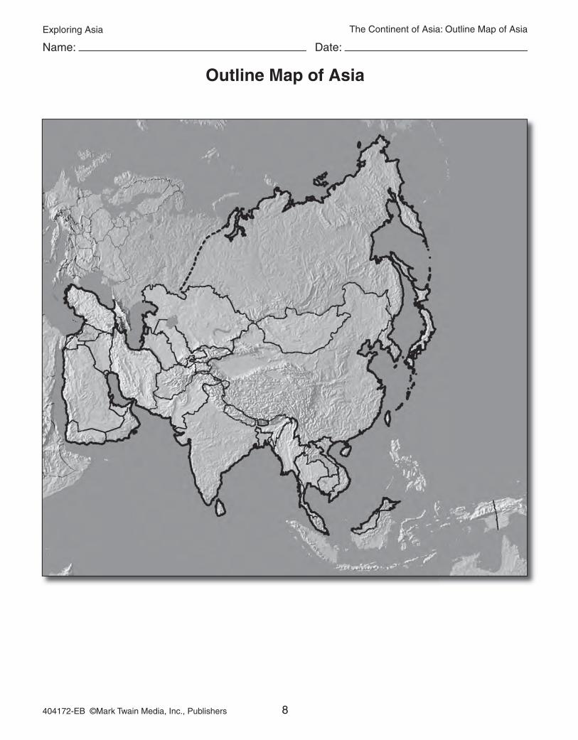
Name: Date:
Outline Map of Asia
The Continent of Asia: Outline Map of Asia

Exploring Asia
9404172-EB ©Mark Twain Media, Inc., Publishers
Name: Date:
Knowledge Check
The Continent of Asia: Knowledge Check
Matching
1. Caspian Sea a. world’s highest point
2. Lake Baykal b. Asia’s longest river
3. Plateau of Tibet c. world’s deepest lake
4. Mount Everest d. referred to as “the roof of the world”
5. Yangtze e. world’s largest lake
Multiple Choice
6. What fraction of the world’s total land surface is located in Asia?
a. 3/4 b. 1/2 c. 1/3 d. 2/3
7. The world’s lowest point is located
a. near the Dead Sea. b. near the Huang River. c. near the Gobi Desert. d. near the Himalayas.
Did You Know?
Mount Everest was named for Sir George Everest, an Englishman who first determined the mountain’s location and height. In 1953, Sir Edmund Hillary of New Zealand and Tenz-ing Morkay of Nepal were the first to climb to its summit.
Constructed ResponseAsia has a wide range of natural features. Describe some of these features using details from the selection to support your answer.

Exploring Asia
10404172-EB ©Mark Twain Media, Inc., Publishers
Name: Date:
Map Follow-Up
Natural Features of Asia
The Continent of Asia: Map Follow-Up
Directions: Draw and label on the map the natural features of Asia listed below.
The Plateau of Tibet Mount Everest Gobi Desert Ural MountainsHimalaya Mountains Syrian Desert Huang River Ganges RiverTigris River Euphrates River Jordan River Caspian SeaLake Baykal Aral Sea

Exploring Asia
11404172-EB ©Mark Twain Media, Inc., Publishers
Name: Date:
Map Follow-Up
Oceans, Seas, Gulfs, and Bays of Asia
The Continent of Asia: Map Follow-Up
Directions: Match the numbers on the map of Asia with the name of the oceans, seas, gulfs, and bays listed below.
Mediterranean Sea Arabian Sea South China Sea
Sea of Japan Arctic Ocean Indian Ocean
Pacific Ocean Red Sea Gulf of Aden
Persian Gulf Bering Sea Bay of Bengal
1
3
4
5
6
7
8
2
9
10
11
12

Exploring Asia
12404172-EB ©Mark Twain Media, Inc., Publishers
Name: Date:
Explore: Fact Cube
The Continent of Asia: Explore
Materials2 sheets of 9 X 12 construction paper old magazine photos notebook paperreading selection information plain paper references glue
Directions: Research one of the Asian countries from the reading selection. Find about the land, culture, language, history, celebrations, food, government, religion, and flag. Create a stand-up paper cube to display the information. Glue magazine pictures or computer-generated graphics on each side of the cube, or create sketches to add interest to your project.
Step 1: Hamburger fold two sheets of construction paper, but fold one of the sheets so that one side is one-half inch shorter than the other side. This makes a flap that extends out one-half inch on one side.
Step 2: Fold the long side over the short side of both sheets, making flaps.
Step 3: Glue along the small folded flap.
Step 4: Place the non-folded edge of the second sheet into the crease and fold the glue-covered flap over this sheet of paper. Do this with the other side.
Step 5: The cube can now be collapsed flat to place information and illustrations on all sides.
Step 6: Display your cube.

Exploring Asia
44404172-EB ©Mark Twain Media, Inc., Publishers
Answer Keys
Answer Keys
The ContinentsKnowledge Check (p. 4)Matching
1. c 2. d 3. e 4. a 5. bMultiple Choice
6. b 7. aConstructed ResponseThe earth’s crust consists of 20 plates. Plate tectonics suggest that these plates move a few inches each year. Over time the plates have moved to their present positions.Map Follow Up (p. 5)
1. North America 2. South America3. Europe 4. Africa5. Antarctica 6. Asia7. Australia 8. Arctic Ocean 9. Atlantic Ocean 10. Indian Ocean
11. Pacific Ocean The Continent of Asia Knowledge Check (p. 9)Matching
1. e 2. c 3. d 4. a 5. bMultiple Choice
6. c 7. aConstructed ResponsePlains make up most of the continent. The Plateau of Ti-bet is over one thousand miles from east to west. Asia has many mountain ranges. The most famous are the Hi-malayas. Deserts are also a major feature of Asia. Large deserts are north of the Himalayas and on the Arabian Peninsula.Map Follow Up (p. 11)
1. Arctic Ocean 2. Mediterranean Sea 3. Red Sea 4. Gulf of Aden 5. Persian Gulf 6. Arabian Sea 7. Indian Ocean 8. Bay of Bengal9. South China Sea 10. Pacific Ocean
11. Sea of Japan 12. Bering Sea
South Asia’s ClimateKnowledge Check (p. 14)Matching
1. b 2. e 3. a 4. c 5. dMultiple Choice
6. b 7. bConstructed ResponseThe summer monsoons blow in from the Indian Ocean and the southern Pacific Ocean. The summer monsoons usually arrive between May and October and bring heavy rains with them. The winter monsoons reverse direction and bring cool, dry air from the northern regions.
Asia’s Resources Knowledge Check (p. 17)Matching 1. e 2. a 3. d 4. c 5. bMultiple Choice 6. a 7. cConstructed ResponseSome of the land has been over-farmed or overgrazed and is no longer productive. Some formerly productive land has become desert. Deforestation is also a major concern.
Asia’s Industries Knowledge Check (p. 20)Matching 1. d 2. b 3. c 4. e 5. aMultiple Choice 6. d 7. bConstructed ResponseMost of Asia’s population is involved in agriculture. How-ever, the continent has low crop yields and primitive farm-ing techniques. Less than one-third of the land is used for farming.
Asia’s Animal LifeKnowledge Check (p. 23)Matching 1. d 2. c 3. e 4. a 5. bMultiple Choice 6. b 7. dConstructed ResponseMost of Asia’s nations do not have laws protecting endan-gered animals. Uncontrolled hunting, increased logging, and the destruction of natural habitats for agriculture have continued to threaten the wildlife population.
The People of Asia Knowledge Check (p. 26)Matching 1. c 2. e 3. b 4. a 5. dMultiple Choice 6. c 7. dConstructed ResponseOverpopulation and poor nutrition are the causes of many of the health care problems. Lack of sanitation and the tropical climate’s insect-breeding grounds add to the spread of many diseases.