VICTORIA WAYFINDING STRATEGY - Victoria, …Hall/Current~Initiatives/VV...on wayfinding projects...
17
VICTORIA WAYFINDING STRATEGY Draft 2 VISUAL VICTORIA—Reimagining our public space MARCH 23, 2017
Transcript of VICTORIA WAYFINDING STRATEGY - Victoria, …Hall/Current~Initiatives/VV...on wayfinding projects...

VICTORIAWAYFINDINGSTRATEGY
Draft 2VISUAL VICTORIA—Reimagining our public spaceMARCH 23, 2017


CONTENTS.
3Victoria Citywide Wayfinding Strategy
01 ABOUT THIS PROJECT ......................................................................................21.1 What is this Document? .................................................................................. 31.2 What is Wayfinding? ........................................................................................ 31.3 Aims and Objectives ....................................................................................... 4
02 INVENTORY & ASSESSMENT PHASE .................................................................62.1 Wayfinding Signage Review ........................................................................... 72.2 Wayfinding Integration ................................................................................... 82.3 Engagement Summary.................................................................................. 122.4 What We Heard ............................................................................................... 14
03 THE WAYFINDING SYSTEM ............................................................................. 163.1 Core Concepts ............................................................................................... 173.2 Sign Type Selection ..................................................................................... 263.3 Sign type library ............................................................................................ 273.4 The City Map ..................................................................................................403.5 Map Feature Specifications .........................................................................46
04 IMPLEMENTATION GUIDE ...............................................................................524.1 Process Overview ........................................................................................ 534.2 Location Plan .................................................................................................. 544.3 Wayfinding Content.......................................................................................58
05 SIGN DESIGN DRAWINGS .............................................................................. 664.1 Thin Pylon ....................................................................................................... 674.2 Wide Pylon...................................................................................................... 744.3 Finger Post ......................................................................................................844.4 Flag Sign: Mixed Use ......................................................................................894.5 Finger Board: Bike Sign ................................................................................. 924.6 Bus Shelter Map .............................................................................................944.7 Transit Post ......................................................................................................98
06 PHASING ...................................................................................................... 1027.1 Defining Priorities ......................................................................................... 1037.1 Phasing Plan...................................................................................................1047.3 Additional Suggestions .....................................................................................

2 Victoria Citywide Wayfinding Strategy
01
ABOUT THIS PROJECT.

3About this project
This Victoria Citywide Wayfinding Strategy has been created by the City of Victoria to facilitate transportation around the city, primarily by pedestrians, cyclists and transit users.
This document is intended to be used as a reference for anyone working
on wayfinding projects within the City of Victoria. The information provided
includes an overview of the process and reasoning behind the wayfinding
system along with descriptions of the individual components of the system
and how they are to be used in a variety of contexts. Recommendations and
suggested work-flow processes are provided to inform the implementation
of the system. Sign construction drawings are provided to a level of detail
that should allow any sign fabricator to reproduce wayfinding elements that
fit seamlessly into the system. Phasing schedules indicate which areas of the
city are priority candidates for the new wayfinding system and the schedule
by which they should be implemented.
1.1 What is this document?
1.2 What is Wayfinding?
Wayfinding refers to systems that help people find their way from one place to another.
It encompasses orientating yourself in space, determining a route to your
destination, reassuring you that you are going the right way and confirming
that you have arrived.
Many elements contribute to city wayfinding, from landmarks to maps to
hand held GPS systems, to asking for directions from a friendly stranger.
Good wayfinding is a blend of art and science. It’s built upon principles
of predictability, consistency, accuracy and legibility. It requires
assisting people to create their own mental maps of their environment.
The addition of a wayfinding system adds clarity to our physical
environment. When executed well, wayfinding systems give pedestrians
the confidence to navigate without fear while encouraging curiosity and
exploration. They have the feeling of arriving at their destination without any
sense of anxiety, and feeling more informed about the journey.
4 Victoria Citywide Wayfinding Strategy
The aim of this project is to efficiently and elegantly direct and assist visitors and residents in navigating their way to key attractions, destinations, public parking and other services and amenities within Victoria.
Implemented along side the Downtown Public Realm Plan, the Wayfinding
Strategy aims to contribute to a memorable and positive image of Victoria
based on its rich history and vision for the future, while enhancing its unique
identity and supporting vitality, accessibility and usability.
The Wayfinding Strategy provides specific guidance on design, siting and
overall approach to wayfinding system elements. The strategy will focus
on the “on-street system” – the signage and other directional, mapping,
identification and information you engage with as you move through the city
– and include considerations for integrating with print and digital media.
The wayfinding strategy supports Victoria’s OCP Heirarchy of Transportation and Mobility Priorities.
1.3 Aims and Objectives

5Inventory & Assessment Phase
Enhanced public realm experience
Encourage alternative modes of transportation
Build community identity
Visitors and locals alike benefit from
a wayfinding system’s ability to
make complex spatial information
clear and legible so it virtually fades
into the background—allowing
them to focus on public events,
art, architecture, retail and local
character, etc.
A goal of the Victoria wayfinding
system is to encourage multi-
modal transportation. It can
inform everyone about previously
unknown assets in the community,
highlight time saving benefits of
walking or cycling versus driving or
waiting for buses.
Creating a positive wayfinding
experience goes a long way toward
reinforcing Victoria as a positive,
inclusive and welcoming place for
newcomers and visitors.
1.3 Aims and Objectives

6 Victoria Citywide Wayfinding Strategy
02
INVENTORY & ASSESSMENT
It’s important to understand
the signage and wayfinding
that currently exists and to
find out how residents and
visitors are used to finding
their way through the city.
SOURCE: Moving Forward: Opportunities for Vancouver’s Digital Wayfinding Map Robert W. White, UBC SCARP MSc Planning Candidate, 2014
People who were more likely to walkafter consulting the map.
82%
People who found the ‘heads up’format easy to use.
87%
People who wanted a printed map inaddition to the physical map stand.
40%

7Inventory & Assessment Phase
2.1 Wayfinding Signage Review
This works but ends and people are left lost after the signs run out
These are an act of genius. Keep doing that.
People appreciate the integrated approach to wayfinding where possible
This is dated
Disjointed wayfinding
Vehicular info only
Interpretive information can be integrated in more informative ways
This is useful
Inlaid work is best for permanent elements
What we thoughtWhat you thought
Through community open houses Phase 1 of the wayfinding strategy process established an understanding of existing wayfinding tools within the city and how residents are used to interacting with them.
The wayfinding strategy incorporates an inventory and assessment of
existing signage and wayfinding infrastructure with community consultation
into how residents and visitors interact with existing city wayfinding.
Pictured here are a selection of examples with commentary provided by the
public and stakeholders.
8 Victoria Citywide Wayfinding Strategy
70x
P
2
2
1
7
7
3
3
3
3
3
3
7N
71
1
14
14
3
2
2
6
6
66A
6B
15
14 1115
15 25
25
25
25
24
24
24
47
24
14
14
26
26
1010
1015
50
71
72
75
61
51
50
50
61
70
4
4
8
10
11
11
22
22
21
26
22N22A
11
8
88
8
8
8
31
30
4
11
11
11
22
27
27
28
28
7
2A
13
1315
25
25
26 2651
24
24
21
31
31
30
30
39
39
39
22
22
22
22
3983
3932
39
71
72
75
70
8
7172
75
7035
1616
61x
53
53
5153
3916
2727
28
28
1212
12
12Islan
d Hwy.
Ocean
BeaconHill Park
Mt. DouglasPark
Oak Bay
CadboroBay
ThetisLake
Ogden PointBreakwater
OAKBAYOAKBAY
SAANICH
ESQUIMALT
VICTORIA
VIEWROYAL
COLWOOD
Cordova Bay Rd.
Royal Oak Dr.
Interurban
Wilkinson
Glanfo
rd
CareyposniknelB Ash
Ferndale
.ywH
yaB
taP
Quadra
McKenzie
Burnside
ArbutusSinclair
Finnerty
FelthamBlair
Cedar Hill X Rd.Saan
ich R
d.
Map
lew
ood
Burnside
Shel
bour
ne
Henderson
Cook
Cedar
Hill
Bay
Lansdowne
Foul
Bay
Rich
mon
d
Craigflower
Lam
pson
Esquimalt
Gorge
Admirals
Belmont
Oak Bay
Beach
Holla
nd
Hastings
Ocean
Admirals
Cowper
Colville
Munro
Fras
er
Old Esquimalt
Lyall
Gore
Dunsmuir
Ross
Central
HaultainFe
rnwo
od
Fort
Windsor
Vict
oria
Bowker
Estevan
Hillside
Skinner
Bay
Majesti
c
Kenmore
McKenzie
Quayle
Cook
Foul
Bay
Cook
Oswego
Cloverdale
Finlayson
Trans Canada
Viaduct
Richardson
May
Fairfield
Emily
Car
r
Chat
terto
n
salgu
oD
Lily
Rogers
Markham
Mem
oria
l
Doug
las
Blan
shar
dQu
adra
CloverPoint
Ferry toPort Angeles
PassengerFerry to Seattle
Helmcken
RoyalJubileeHospital
UVic
HillsideCentre
HendersonRec. Centre Gyro
Park
CattlePoint
WillowsBeach
Oak BayMarina
TillicumMall Saanich
Plaza
Silver City& Pearkes
Arena
DNDWork PointBarracks
Broadmead Village
Commonwealth Pool
VancouverIsland
Tech Park
RoyalOak
ShoppingCentre
RoyalOak
ShoppingCentre
Gordon HeadComm. Centre
UniversityHeights
ShoppingCentre
SaanichCentre
FairfieldPlaza
MayfairShopping
Centre
CamosunCollege
Lansdowne
WestshoreRecreation
Centre
Gordon
Head
Tynd
all
Tillicu
m
EsquimaltPlaza
Obed
Uptown
Cadb
oro Ba
y
N
EsquimaltHarbour
AdmiralsWalk
Dockyard
P
Vic General
14 22 39
Uptown
31 71 72 75
16 70 26 30
Beacon Hill
27 28 3 30
Legislature
75 66 99
31 32 61 71 72
50 70 27 28 30
Camosun
8 21 22N
39 83
PENINSULA
UVic
12 13 26 39 51 76
15 16 4 14 7 11
X
Royal Oak
70 6 31 32 35
39 71
30
72 75 83
X
Colwood
50 25 39
52 53 54 61
48 51
X
WES
TSHORE
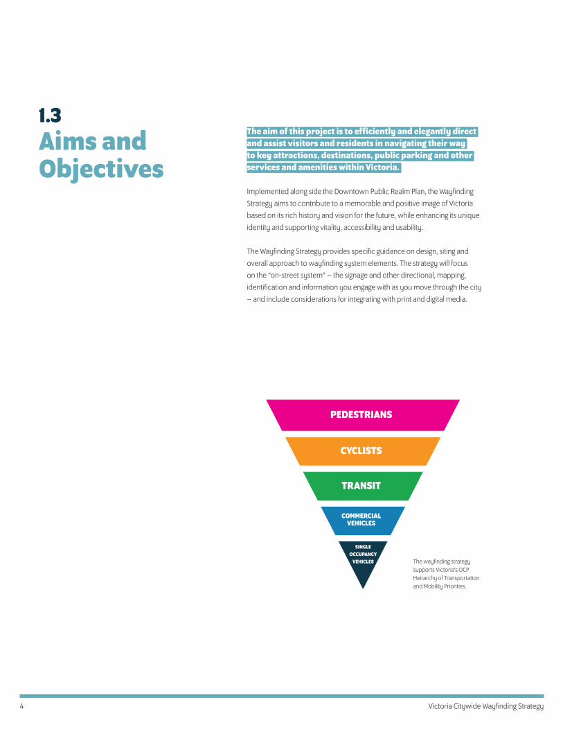
In terms of BC Transit’s role in wayfinding and trip planning, notable
standards include the colour palette and icons associated with local and
regional transit routes as well as the arrangement of information presented
on bus schedules, stops and maps.
Different maps perform different functions, as expressed by these preceding three versions of the city. It will be important to adhere to the principles of wayfinding in order to generate map styles which are the most useful for citywide navigation.
Important considerations are how much information to give in order to allow
users to understand a general picture of their entire journey as well as giving
them clarity around the micro decision of which way to turn in order to
begin—or in the case of a transit map—“which bus route do I need and where
do I catch that bus?”
BC Transit maps necessarily focus on routes and general location areas rather than destinations. The graphic style reflects this requirement—with linear information appearing as the most dominant element.
2.2 Wayfinding Integration: BC Transit

9Inventory & Assessment Phase
Visual standards
The visual standards and symbols employed by B.C. Transit represent a
familiar information set for local users and a quickly recognizable one
for visitors to the city. It is recommended that wherever possible, the
wayfinding strategy should align with these standards at all points of
reference between the two systems.
Notable standards include the colour palette and icons associated
with local and regional transit routes as well as the arrangement of
information presented on bus schedules, stops and maps.
123 456
250·339·5453
www.bctransit.com
Victoria Regional Transit Commission
250·382·6161
70 Downtown
06 Downtown
30 James Bay
32 Cordova Bay
35 Ridge
000001
ONLINE information systems
Users of B.C. Transit are able to access information from a number of sources,
from smart phones to printed schedules. These systems compliment on-
site wayfinding and their effect on a users journey through the city should
be considered, however their level of adoption and use is mixed and it is
important on-site wayfinding function independently from these sources.
Direction of Travel
Route Name
Transit Exchange
Park & Ride Lot
Major Stop
Regional Route
Frequent Route
Local Route
2
P
X
UVic
Direction of Travel
Route Name
Transit Exchange
Park & Ride Lot
Major Stop
Regional Route
Frequent Route
Local Route
2
P
X
UVic
As noted, developing a comprehensive wayfinding strategy for the City of Victoria will necessarily involve integrating several established systems and visual standards.
As a critical element of the city’s transportation network, B.C. Transit warrants
special consideration. Existing standards can inform the new wayfinding
strategy and points of connection should be identified to maintain
consistency for travelers as they transition from one means of transport to
another.
Online maps at bctransit.com are Googlemap overlays
2.2 Wayfinding Integration: BC Transit
10 Victoria Citywide Wayfinding Strategy
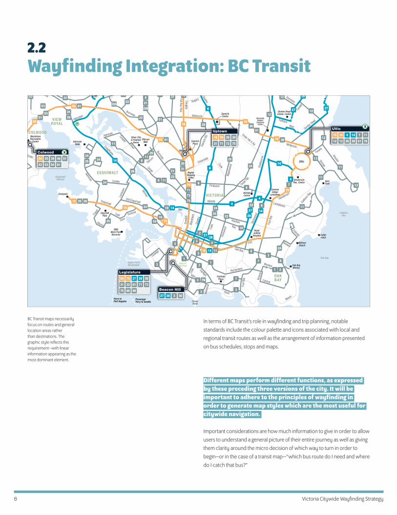
Signage System For Everyday Trips By Bike
For a variety of reasons including speed and distance traveled by cyclists,
the recommendations focus on signage rather than maps. A number of
sign types are outlined, as shown below. Any signs that contain maps
are extremely simple and designed to be read without stopping for the
convenience of cyclists.
In 2014, the Capital Regional District (CRD) prepared wayfinding signage guidelines to assist municipalities within it’s district in preparing systems for cyclists.
The document Interim Cycling Destination Wayfinding Guidelines,
which is part of the CRD’s Pedestrian and Cycling Master Plan, notes that
the intention “is to allow municipalities to streamline signage slowly, over
time, replacing signage at their discretion on an as-needed basis as funding
becomes available, in order to increase legibility for cyclists navigating our
region.”
Related objectives within the PCMP are:
Objective 3: to promote regional consistency, continuity and connectivity,
Strategy 3.1: Develop common standards for pedestrian and
cycling design guidelines
Strategy 3.2: Develop a common wayfinding signage system
“Inter-municipal regional-scale trips are more likely to be completed by
bicycle than by foot because of the distances involved; therefore, it is of
higher priority at this time to ensure that cyclists encounter information in
a standardized way across the region.” —CRD Interim Cycling Destination
Wayfinding Guidelines, 2014
The wayfinding system proposed should be compatible, clear and recognizable by users traveling through or from other jurisdictions.
Principles in place for wayfinding signage for the remainder of the CRD,
Province and continent should be followed. This is particularly important for
cyclists who will be traveling through multiple jurisdictions on roadways with
other traffic at comparable speeds.
2.2 Wayfinding Integration: Bike Routes
D Decision sign
On the approach to a decision point, decision signs point the direction to control destinations.
Destination II
Destination I
Destination III
rmation sign
rmation signs reassure cyclists of
rm additional destinations reached along that route.
Destination V 1Destination I 8
Destination IV 0.5
ngerboard
Fingerboard signs should be placed after the decision sign, at the point of the turn.
Destination I Destination II
Destination II
Destination I
Destination III
ROUTE NAME
Destination I
Destination II
Destination III
Destination I
Destination II
Destination I via quiet route
Map type signs should be considered unique to the circumstances they depict. The signs shown are illustrative of possible approaches.
BIKE ROUTE
11Inventory & Assessment Phase
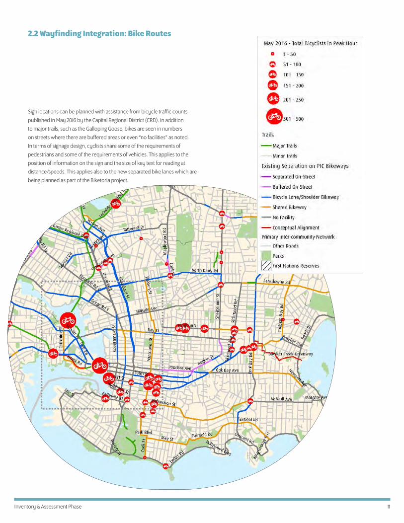
Sign locations can be planned with assistance from bicycle traffic counts
published in May 2016 by the Capital Regional District (CRD). In addition
to major trails, such as the Galloping Goose, bikes are seen in numbers
on streets where there are buffered areas or even “no facilities” as noted.
In terms of signage design, cyclists share some of the requirements of
pedestrians and some of the requirements of vehicles. This applies to the
position of information on the sign and the size of key text for reading at
distance/speeds. This applies also to the new separated bike lanes which are
being planned as part of the Biketoria project.
2.2 Wayfinding Integration: Bike Routes

12 Victoria Citywide Wayfinding Strategy
2.3 Engagement Summary
The public, City staff and stakeholders were asked specific questions addressing topics such as the wayfinding work they are currently doing, if any, the needs of their users, capabilities for mapping and potential for overlap of infrastructure. In addition, everyone was asked to comment on the following questions:
Audience: Who is the wayfinding system for? Who are we speaking to?
Destinations: What are they trying to find and where are they getting lost?
Brand Character: Because wayfinding offers graphic information
reinforcing a visual brand of the city of Victoria, what words describe that
brand?
Visual Approach: In terms of a streetscape design, what is the role
of wayfinding signage? How visually dominant a feature should the
wayfinding system be?
Challenges and Opportunities: In your own words, what do
you envision for the wayfinding project in terms of challenges and
opportunities?

13Inventory & Assessment Phase
Audiences
In summary, really it’s for everyone. There’s no doubt that wayfinding will
be useful to visitors and newcomers to Victoria. But it’s also helpful to locals,
pointing out connections and destinations that are new as well as creating
a more robust mental map of their city for locals. Here is a list of what we
heard when asking “Who is the wayfinding system for?” It’s important to keep
in mind that this system can be for a wide variety of users:
• Tourists: out-of-towners; visitors; cruise ship embarkees;
explorers of themes (e.g. green spaces)• Newcomers: students; temporary workers; new residents • Non-English speakers• Locals—“I don’t know where I’m going”; event goers; regional residents;
new transit users; new cyclists• Kayak/harbour users• Motorists• Bike tours• Anyone looking for the basics—“I’m hungry”• Locals looking to find new destinations, e.g. farmers’ markets• History buffs—“can there be an interpretive component?”
Destinations fall into a variety of categories and the responses were distilled into a list of places that we heard people feel visitors, newcomers and long time residents will want to use the system to find.
2.3 Engagement Summary

14 Victoria Citywide Wayfinding Strategy
Beautiful harbour city setting
Walkable
Heritage/historic city
Express authenticity of place
Easily accessible—by ferry, by air
Great climate
Not just for retirees anymore
Provincial capital
“Secret” alleyways
Amazing cuisine
Diverse, creative community
Bikeable
Architecturally interesting
First Nations heritage
Tech industry
Cultural: music, theatre, film, dance,
art
Sports: cycling, sailing, scuba
Natural: birds, gardens, ocean,
whales
Victoria’s brand & character
The visual approach to the wayfinding system will be citywide and therefore indicative of the character of the “Victoria brand”. We asked the question: “What impression of Victoria should come across in the wayfinding system? ”
The following is a list of the answers we have received, organized according
to those with the most consensus, from the top.
First Nations place naming
We heard from many people that the wayfinding system should incorporate
First Nations place naming, language and potentially artwork. The City
of Victoria has therefore been consulting with representatives of the
Lekwungen Nation in order to determine the best ways to do that. Further in
this document, options for recognizing this important relationship to the land
are outlined in the drawings for the Thin and Wide Pylons.
Historic
Walkable
Beautiful harbour city
2.4 What we heard
Butch Dick, Killer Whale Transforming to a Sea Wolf

15Inventory & Assessment Phase
Visual Approach
In terms of a streetscape design, what is the role of wayfinding signage? How visually dominant a feature should the wayfinding system be?
Wayfinding can integrate with the public realm in different ways. Examples
are shown below which can be considered along a spectrum from quiet
wayfinding signage that allows cityscape or architecture to be the focus to
colourful and fun design which attracts attention for it’s expressive qualities.
Thinking of this spectrum, which approach seems more suited to the city of
Victoria than others? Should wayfinding signage be “there when you need
it” and less visible when you don’t? Should wayfinding signage express some
aspect of precinct character through shifts in colour or form from one area
to the next? Should wayfinding signage be expressive and attract attention
for it’s form and or colour?
CONSISTENT BACKGROUND
COLOURFUL FOCAL POINT
MOREEXPRESSIVE FORM
SIMPLE MOVESKEYED TO AREAS
At the Public Open House and City storefront gallery, we asked people
to place a dot on the spectrum above to indicate what they felt the visual
dominance of wayfinding signage should be within the public realm. While
far from a scientific approach, the results we received indicate that a position
to the centre-left felt more appropriate for the project.
2.4 What we heard