VEGETATION REPORT - SAHRIS
48
VEGETATION REPORT PROPOSED EXPANSION OF EXISTING AFRIMAT QUARRY NEAR HLUHLUWE, KWAZULU-NATAL Gerhard Botha PO Box 12500, Brandhof, 9324 Cell: 084 2073454 Email: [email protected] January 2015
Transcript of VEGETATION REPORT - SAHRIS

VEGETATION REPORT PROPOSED EXPANSION OF EXISTING AFRIMAT QUARRY NEAR HLUHLUWE,
KWAZULU-NATAL
Gerhard Botha
PO Box 12500, Brandhof, 9324
Cell: 084 2073454
Email: [email protected]
January 2015
Vegetation Report – Proposed Expansion of Hluhluwe Quarry January 2015
i
EXECUTIVE SUMMARY AFRIMAT (Pty) Ltd. has appointed GreenMined Pty (Ltd.) to manage the EIA process for the expansion of an existing gravel quarry located north of the town of Hluhluwe, KwaZulu Natal. The proposed site earmarked for the expansion is situated to the north, north-east of the existing quarry on predominantly natural veld with only a small portion of transformed (cleared area) land, just north-east of the existing quarry. Most of the surrounding land is used for game farming. The study area falls within the Big 5 False Bay Local and uMkhanyakude District Municipalities. This report discusses the approach, findings of a floral field study, and literature survey carried out for the study area to assess the likelihood of floral sensitivities occurring on the study area. The findings of this report should be used to guide the design of the final layout of the proposed development as well as environmental issues that will have to be adequately addressed and mitigated during the design, construction, operational and decommissioning phase. The study area is situated in the Savanna Biome, and is covered by the Zululand Lowveld (SVI 23) vegetation type (Mucina & Rutherford, 2006), also formerly known as Lowveld (Acocks, 1953) and Natal Lowveld Bushveld/Sweet Lowveld Bushveld (Low & Rebelo, 1996). This vegetation type is regarded as Vulnerable by Mucina & Rutherford (2006) and falls within the Black Rhino Range Ecosystem (KZN 41) which is also listed as Vulnerable in the threatened terrestrial ecosystems for South Africa (2011).
The vegetation is in a natural, largely undisturbed state. The study area had a uniform type of vegetation structure and composition and the area can be described as a relative open thornveld made up of tall grasses (Hyparrhenia species), interspersed between small trees and large shrubs, mainly Acacia species and Dichrostachys cinerea. A small number of broad leaved trees are however found scattered in between. The dense, tall grass cover consist predominantly out of class one increasing, climax species, which is indicative of underutilization (undergrazing). Two protected tree species were found namely; Sclerocarya birrea subsp. caffra and Boscia albitrunca. These two tree species are protected according to Schedule A of the National Forest Act of 1998 (Act No. 84 of 1998). Due to the fact that the natural vegetation is largely still intact and in good condition, almost no habitat is available for invading weeds and exotics. The only problematic plant species noted was Chromolaena odorata, which is a highly aggressive Category 1 Alien Invasive capable of invading undisturbed natural vegetated areas.Three main vegetation units were identified namely: Vegetation Unit 1: (Acacia tortilis subsp. heterocantha – Hyparrhenia flipendula unit), Vegetation Unit 2: (Dichrostachys cinerea – Acacia

Vegetation Report – Proposed Expansion of Hluhluwe Quarry January 2015
ii
tortilis subsp. heterocantha) and Vegetation Unit 3: Acacia nilotica - Hyparrhenia flipendula unit. Due to the small size of the proposed development, the uniformity of habitat and vegetation structure as well as the underutilization of the area by game, lifestock and human the conservation value and ecosystem function of the study site can be regarded as Medium. Furthermore according to the Biodiversity Sensitivity Rating, the study area is regarded a Medium - High Sensitive Area

Vegetation Report – Proposed Expansion of Hluhluwe Quarry January 2015
iii
Table of Contents EXECUTIVE SUMMARY ........................................................................................................................ i
1. INTRODUCTION .......................................................................................................................... 5
1.1. SCOPE OF PROPOSED DEVELOPMENT ............................................................................... 5
1.2. OBJECTIVES ....................................................................................................................... 6
1.3. Legislation ........................................................................................................................... 6
1.4. General assumptions and limitations ........................................................................................ 7
1.4.1. General assumptions ......................................................................................................... 7
1.4.2. Limitations ....................................................................................................................... 7
1.5. Conditions of this report ......................................................................................................... 8
2. METHODS OF INVESTIGATION .................................................................................................... 8
2.1. Desktop Study ...................................................................................................................... 8
2.2. Fieldwork ............................................................................................................................. 9
2.3. Criteria used to assess sites ................................................................................................... 9
2.4. Biodiversity sensitivity rating (BSR) ........................................................................................ 13
3. STUDY AREA ............................................................................................................................ 15
3.1. Locality, Topography and Land Use ....................................................................................... 15
3.2. Climate and rainfall (Mucina & Rutherford, 2006) ..................................................................... 19
3.3. Geology & Soils (Mucina & Rutherford, 2006) .......................................................................... 19
3.4. Vegetation overview ............................................................................................................ 19
4. Results and Discussion ............................................................................................................... 21
4.1. General vegetation description .............................................................................................. 21
4.2. Vegetation Unit Description .................................................................................................. 22
4.2.1. Vegetation unit 1 ............................................................................................................. 23
4.2.2. Vegetation unit 2 ............................................................................................................. 23
4.2.3. Vegetation unit 3 ............................................................................................................. 23
4.3. Habitat and Species Summary .............................................................................................. 24
4.4. Biodiversity Sensitivity Rating of the study area ....................................................................... 25
5. CONCLUSION & RECOMMENDATIONS ....................................................................................... 28
6. REFERENCES .......................................................................................................................... 33

Vegetation Report – Proposed Expansion of Hluhluwe Quarry January 2015
iv
Tables Table 1: Biodiversity Sensitivity Ranking ................................................................................................ 13 Table 2: Summary of key taxa found within Zululand Lowveld (SVI 23) ....................................................... 20 Table 3: Habitat and land use summary for Unit 1 ................................................................................... 24 Table 4: Biodiversity Sensitivity Rating for Unit 1. .................................................................................... 25 Table 5: A species list from POSA (http://posa.sanbi.org, January 2015, Grid reference: 3030BC).................. 43 Table 6: A species list from POSA (http://posa.sanbi.org, January 2015, Grid reference: 2732CC) ................. 46
Appendixes
APPENDIXES ............................................................................................................................... 34
PHOTOS OF STUDY AREA ........................................................................................................ 35
SPECIES LIST OF STUDY AREA .............................................................................................. 42
SPECIES LIST OBTAINED FROM POSA ................................................................................. 45

Vegetation Report – Proposed Expansion of Hluhluwe Quarry January 2015
5
1. INTRODUCTION South Africa is committed to the Convention of Biological Diversity, and has introduced several legislative mechanisms to ensure that the preservation and sustainable use of all biological diversity, including ecosystem, species, and genetic diversity, is guaranteed for the benefit of current and future generations in South Africa and beyond. The impact of past and present conversion of natural habitat types by cultivation, grazing, urban developments, forestation, mining, dams, industries, and alien plant invasions continues to have a substantial impact on South African biodiversity, with significant portions of South Africa’s flora and fauna being threatened (Wynberg 2002). Arid, semi-arid and dry sub-humid areas, covering an estimated 91% of South African land area (Hoffman and Ashwell 2001), including the study area, are particularly prone to degradation arising from human activities, leading to the acceleration of soil erosion, deterioration of the biotic, abiotic and economic properties of soil, and the long-term loss of natural vegetation (UNCCD 1995) and associated habitats for fauna. Rapid recovery of degradation is inhibited by the loss of topsoil and natural seed banks, and the unpredictability of rainfall events.
This report lists the findings of a floral evaluation of the site selected for the expansion of an existing gravel quarry north of the town of Hluhluwe, KwaZulu-Natal in order to help evaluate the possible impacts of such a development on the affected environment.
1.1. SCOPE OF PROPOSED DEVELOPMENT AFRIMAT (Pty) Ltd. proposes an expansion of their existing quarry located north of the town of Hluhluwe (±14 km). The property is situated just east of the N2 adjacent to a secondary gravel road (running parallel with the N2). With regards to the proposed site earmarked for the expansion of the quarry, the site is situated to the north, north-east of the existing quarry on predominantly natural veld with only a small portion of transformed (cleared area) land, just north-east of the existing quarry. Most of the surrounding land is used for game farming. This report will form an integral part of the finalization of the layout of the facility and associated infrastructure.

Vegetation Report – Proposed Expansion of Hluhluwe Quarry January 2015
6
1.2. OBJECTIVES To conduct a Vegetation study and impact assessment of the selected target area in order to:
identify any sensitive areas;
compile sensitivity map according to results;
identify any Red Data Species and Protected Species;
investigate the possible impact of the development on the immediate environment as well as the surrounding environment;
draw a conclusion from above mentioned and present recommendations and mitigation measures to protect sensitive areas and to keep environmental destruction to an absolute minimum.
1.3. Legislation The following legislation was taken into account whilst compiling the following report:
A. Provincial
KwaZulu Nature Conservation Act (Act 29 of 1992) in its entirety, with special reference to:
- Schedule 9: Unprotected Indigenous Plants
- Schedule 10: Protected Indigenous Plants
- Schedule 11: Specially Protected Indigenous Plants
B. National
National Environmental Management Act / NEMA (Act No 107 of 1998), and all amendments and supplementary listings and/or regulations
Environment Conservation Act (ECA) (No 73 of 1989) and amendments
National Environmental Management Act: Biodiversity Act / NEMA:BA (Act No. 10 of 2004) and amendments
National Forest Act 1998 / NFA (No 84 of 1998)

Vegetation Report – Proposed Expansion of Hluhluwe Quarry January 2015
7
National Veld and Forest Fire Act (Act No. 101 of 1998)
Conservation of Agricultural Resources Act / CARA (Act No. 43 of 1983) and amendments
C. International
Convention on International Trade in Endangered Species of Fauna and Flora (CITES)
Convention on Biological Diversity, 1995
1.4. General assumptions and limitations
1.4.1. General assumptions This study assumes that the project proponents will always strive to avoid, mitigate
and/or offset potentially negative project related impacts on the environment, with impact avoidance being considered the most successful approach, followed by mitigation and offset. It further assumed that the project proponents will seek to enhance potential positive impacts on the environment.
GIS spatial datasets used as part of the field surveys (site demarcation) and analyses are accurate.
The project proponents will commission an additional study to assess the impact(s) if there is a change in the size, location and/or extent of the study area that is likely to have a potentially highly significant and/ or unavoidable impact on the natural environment
1.4.2. Limitations The following refers to general limitations that affect the applicability of information represented within this report (Also refer to Conditions of the Report):
This report only focuses on the identification and classification of vegetation units restricted to the study area (See also: Conditions of this report).
Vegetation Report – Proposed Expansion of Hluhluwe Quarry January 2015
8
A single baseline assessment was conducted.
Accuracy of the maps, routes and desktop assessments is based on the current 1:50000 topographical map series of South Africa;
Accuracy of Global Positioning System (GPS) coordinates was limited to 8 m accuracy in the field.
A single survey limited the amount of biota identified at the site; and
Whilst every care is taken to ensure that the data presented are qualitatively adequate, inevitably conditions are never such that that is possible. Under the circumstances it must be pointed out that the nature of the vegetation, the time of year, human intervention etc. limit the veracity of the material presented.
1.5. Conditions of this report Findings, recommendations and conclusions provided in this report are based on the authors’ best scientific and professional knowledge and information available at the time of compilation. The author, however, accepts no liability for any actions, claims, demands, losses, liabilities, costs, damages and expenses arising from or in connection with services rendered, and by the use of the information contained in this document. No form of this report may be amended or extended without the prior written consent of the author. Any recommendations, statements or conclusions drawn from or based on this report must clearly cite or make reference to this report. Whenever such recommendations, statements or conclusions form part of a main report relating to the current investigation, this report must be included in its entirety.
2. METHODS OF INVESTIGATION
2.1. Desktop Study A desktop analysis was conducted to generate a checklist of the flora expected to occur in the region and to identify species that are of concern to conservation. A species list from POSA (http://posa.sanbi.org, January 2015, Grid reference: 2732CC) containing the species that

Vegetation Report – Proposed Expansion of Hluhluwe Quarry January 2015
9
might occur in the area was obtained. POSA generated species lists also contain updated Red Data species status according to the Red List of South African Plants 2009 published by SANBI in Strelitzia 25 (Raimondo et al. 2009).
Vegetation maps as well as Google maps where utilized prior to site investigation. The vegetation was delineated into homogenous units on currently available Google Earth imagery.
2.2. Fieldwork The proposed site was visited on the 26th of November 2014. A primitive delineated vegetation map compiled during the desktop study was used as reference and within each homogeneous unit, a number of representative plots (10 m X 10m) were selected and the total visible floristic composition was noted within each plot. Every plot was accompanied by GPS coordinates and as much environmental data as could possibly be observed.
2.3. Criteria used to assess sites Several criteria were used to assess the vegetation units and determine the overall status of the units as well as the greater environment.
Vegetation characteristics
The characteristics of the vegetation in its current state were analysed, focusing on the diversity of species, sensitivity of habitats and importance of the ecology as a whole.
Habitat Diversity and Species Richness
Score Description
1 High diversity of species including a number of species confined to a specific niche.
2 Habitat dominated by a medium to low species diversity. Occupied by species present through a number of vegetation units.
3 Low diversity. Usually a monotonous specie or a few species dominant over a large area.

Vegetation Report – Proposed Expansion of Hluhluwe Quarry January 2015
10
Presence of rare and endangered species
Score Description
1 Occurrence actual or highly likely.
2 Occurrence possible.
3 Absent or highly unlikely.
Ecological function
Score Description
1 Ecological function critical for greater system.
2 Ecological function of medium importance.
3 No special ecological function.
Degree of rarity/conservation value
Score Description
1 Very rare and/or in exceptional condition.
2 Fair to good condition and/or relatively rare
3 Not rare, degraded and/or poorly conserved
Vegetation condition
The units are compared to a benchmark site in a good to excellent condition. Vegetation management practises (e.g. grazing regime, fire management, etc.) can have a marked impact on the condition of the vegetation.

Vegetation Report – Proposed Expansion of Hluhluwe Quarry January 2015
11
Percentage ground cover: Ground cover is under normal and natural conditions a function of climate and biophysical characteristics. Under poor grazing management, ground cover is one of the first signs of vegetation degradation.
Score Description
1 Good to Excellent
2 Fair
3 Poor
Vegetation structure: This is the ration between tree, shrub, sub-shrubs and grass layers. The ration could be affected by grazing and browsing by animals as well as anthropogenic influences.
Score Description
1 All layers still intact and showing specimens of all age classes.
2 Sub-shrubs and/or grass layers highly grazed while tree layer still fairly intact (bush partly opened up)
3 Mono-layered structure often dominated by a few unpalatable species (presence of barren patches notable).
Infestation with exotic weeds and invader plants or encroachers:
Score Description
1 No or very slight infestation levels by weeds and invaders.
2 Medium infestation by one or more species.
3 Several weed and invader species present and high occurrence of one or more species.

Vegetation Report – Proposed Expansion of Hluhluwe Quarry January 2015
12
Degree of grazing/browsing impact:
Score Description
1 No or very slight notable signs of browsing and/or grazing.
2 Some browse lines evident, shrubs show signs of browsing, grass layer grazed though still intact.
3 Shrubs heavily pruned and grass layer almost absent.
Signs of erosion: The formation of erosion scars can often give an indication of the severity and/or duration of vegetation degradation.
Score Description
1 No or very little signs of soil erosion.
2 Small erosion gullies present and/or evidence of slight sheet erosion.
3 Gully erosion well developed (medium to large dongas) and/or sheet erosion removed the topsoil over large areas.
Degree of grazing/browsing impact:
Score Description
1 No or very slight notable signs of browsing and/or grazing.
2 Some browse lines evident, shrubs show signs of browsing, grass layer grazed though still intact.
3 Shrubs heavily pruned and grass layer almost absent.

Vegetation Report – Proposed Expansion of Hluhluwe Quarry January 2015
13
2.4. Biodiversity sensitivity rating (BSR) The total scores for the criteria above were used to determine the biodiversity sensitivity ranking for the sites. On a scale of 0 – 30, five different classes are described to assess the suitability of the units to the development. The different classes are described in the table below:
Table 1: Biodiversity Sensitivity Ranking
BSR BSR general floral description Floral score equating to BSR class.
Low Sensitivity (5)
Areas that have been previously transformed or disturbed or areas that provide limited ecosystem services, or have a low ecological value. Species diversity may be low or all species present have a much wider distribution beyond this habitat or locality. Species of conservation concern may be present on such areas, but these are not restricted to these habitats and can be relocated with ease. Further arguments may include landscapes where the abiotic nature is such that it can be rehabilitated relatively easy to allow the re-establishment of the original species composition, and where the development will not lead to any unjustified degradation of landscapes or ecosystem services if adequately mitigated.
25- 30
Medium Low Sensitivity (4)
Areas with a high species diversity but with few species of conservation concern, this could also include areas with previous disturbance or transformation, where the impact of the development will lead to irreversible, unjustified degradation of the landscapes that will be difficult to prevent and mitigate. Also areas where the landscape can be rehabilitated to allow the re-
21-24

Vegetation Report – Proposed Expansion of Hluhluwe Quarry January 2015
14
establishment of most or all of the original species composition after physical alteration
Medium-High Sensitivity (3)
Areas where the landscape can be rehabilitated to allow the re-establishment of some of the original species composition after physical alteration, but some of the species of conservation concern or ecosystem functionality may be lost with a high species diversity and potentially higher number of species of conservation concern.
11- 20
High Sensitivity (2)
Areas that are relatively undisturbed or pristine and are either very species-rich relative to immediate surroundings, or have a very unique and restricted indigenous species composition. Alternatively, these areas also constitute specific habitats or a high niche diversity for fauna and/or flora species of conservation concern, and where the total extent of such habitats and associated species of conservation concern remaining in southern Africa is limited. Excessive disturbance of such habitats may lead to ecosystem destabilisation and/or species loss. This would also include areas where the abiotic environment is of such nature that the habitat and its niche-diversity are the main reason for a higher species diversity and cannot be reconstructed or rehabilitated once physically altered in any way.
0 - 10

Vegetation Report – Proposed Expansion of Hluhluwe Quarry January 2015
15
3. STUDY AREA
3.1. Locality, Topography and Land Use According to the classification of Mucina & Rutherford (2006) the topography of the area can be described as extensive flat or only slightly undulating landscapes supporting complex of various bushveld units.
AFRIMAT (Pty) Ltd.’s Hluhluwe quarry is situated just east of the N2 adjacent to a secondary gravel road (running parallel with the N2). With regards to the proposed site earmarked for the expansion of the quarry, the site is situated to the north, north-east of the existing quarry on predominantly natural veld with only a small portion of transformed (cleared area) land, just north-east of the existing quarry. Most of the surrounding land is used for game farming. Regarding the typography of the proposed site; the site is situated on a north-east facing slope of a hilly area and include a section of the crest, the middle slope, foot slope and a section of the low lying valley. During the desktop study a number of, what seems to be, drainage lines with denser vegetation cover are present throughout the surrounding area, all running in a north-easterly direction ultimately draining into a large channelled valley bottom wetland system (valley floor), which is listed as a NFEPA wetland.

Vegetation Report – Proposed Expansion of Hluhluwe Quarry January 2015
16
Figure 1: The approximate positions of the selected site. Note the number of drainage lines (darker vegetation) and the large NFEPA channelled valley bottom wetland in the north (Dark dense vegetation).
PROPOSED EXPANSION OF HLUHLUWE QUARRY, KWAZULU-NATAL
APPROXIMATE POSITION OF SELECTED SITE.
LEGEND
Existing quarry and infrastructure
Proposed area for expansion
Vegetation Report – Proposed Expansion of Hluhluwe Quarry January 2015
17
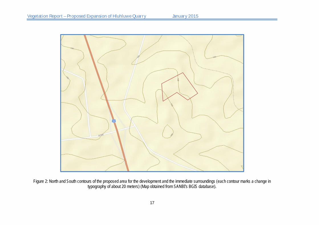
Figure 2: North and South contours of the proposed area for the development and the immediate surroundings (each contour marks a change in typography of about 20 meters) (Map obtained from SANBI’s BGIS database).

Vegetation Report – Proposed Expansion of Hluhluwe Quarry January 2015
18
Figure 3: South-east to north-west elevation profile of a section of the area selected for the proposed development (Google Earth).

Vegetation Report – Proposed Expansion of Hluhluwe Quarry January 2015
19
3.2. Climate and rainfall (Mucina & Rutherford, 2006) Rainfall occur mainly in the summer months (mean annual precipitation: 500 - 900 mm) although some rainfall may also occur in winter. Mean annual precipitation increases along a west to east gradient, with the highest precipitation occurring in the south-eastern parts. High evaporative rates however reduce the efficiency of this rainfall considerably (mean annual potential evaporation: 1898 mm). The region is furthermore also characterized the general absence of frost. The mean maximum and minimum monthly temperatures for Mpila Camp (Hluhluwe-iMfolozi Park) are 38.5°C and 7.8°C for February and June, respectively.
Figure 4: Climate summary for KwaZulu-Natal Coastal Belt (CB 3) (Mucina & Rutherford, 2006).
3.3. Geology & Soils (Mucina & Rutherford, 2006) Zululand Lowveld (SVI 23) is characterized by black-clay soils and duplex soils derived from a distinct variety of clastic sediments of the Dwyka, Ecca, Beaufort and igneous rocks of the Lebombo Groups (all of the Karoo Supergroup). Also well-drained soil forms occur especially on stony slopes. Land types are predominantly Fb and Ea with some Db and Dc.
3.4. Vegetation overview The selected development site is situated within the original extent of the Zululand Lowvled (SVI) as classified by Mucina and Rutherford (2006). These flat to slightly undulating landscapes support various bushveld units which can range from dense thickets of

Vegetation Report – Proposed Expansion of Hluhluwe Quarry January 2015
20
Dichrostachys cinerea and Acacia species, through park-like savanna with flat-topped A. tortilis to tree-dominated woodland with broad leaved open bushveld with Sclerocarya birrea subsp. caffra and A. nigrescens. Tall grassveld types with sparsely scattered solitary trees and shrubs form a mosaic with the typical savannah thornveld, bushveld and thicket patches (Mucina and Rutherford, 2006). Overgrazing of the dominant palatable species characterizing the ground layer, such as Themeda triandra and Panicum maximum, causes the replacement of these species with less palatable species such as; Eragrostis spp, Schmidtia pappophoroides, Aristida congesta subsp. congesta, A. bipartita and Urochloa mosambicensis. Severe overgrazing and trampling by lifestock may result in bush encroachment with Acacia species, especially Acacia karroo, resulting in dense thickets of A. karroo and a considerable reduction in productivity of the grass layer.
Zululand Lowveld is regarded as Vulnerable by Mucina & Rutherford (2006) and falls within the Black Rhino Range Ecosystem (KZN 41) which is also listed as Vulnerable in the threatened terrestrial ecosystems for South Africa (2011).
Table 2: Summary of key taxa found within Zululand Lowveld (SVI 23)
ZULULAND LOWVELD (SVI 23)
Growth form Species
Tall Trees Acacia burkei, A. nigrescens, Sclerocarya birrea subsp. caffra
Small Trees Acacia tortilis subsp. heteracantha, A. gerrardii, A. natalitia, A. nilotica. A. senegal var. rostrata, A.
welwitschii subsp. welwitschii, Boscia albitrunca, Combretum apiculatum, C. molle, Ozoroa paniculosa, Phoenix reclinata, Schotia brachypetala, Spirostachys africana, Teclea gerrardii, Ziziphus
mucronata.
Succulent Trees Aloe marlothii subsp. marlothii, Euphorbia grandidens, E. ingens.
Tall Shrubs Dichrostachys cinerea, Euclea divinorum, Coptosperma supra-axillare, Crotalaria monteiroi, Euclea
crispa subsp. crispa, E. schimperi, Galpinia transvaalica, Gardenia volkensii, Gymnosporia maranguensis, G. senegalensis, Jatropha zeyheri, Lycium acutifolium, Olea europaea subsp.
africana, Tarchonanthus parvicapitulatus, Tephrosia polystachya, Truimfetta pilosa var. tomentosa
Low Shrubs Barleria obtuse, Crossandra greenstockii, Felicia muricata, Gymnosporia heterophylla, Indigofera trita
subsp. subulata, Justicia flava, J. protracta subsp. protracta, Melhania didyma, Orthosiphon serratus, Pearsonia sessilifolia, Ruellia cordata, Sida serratifolia, Tetraselago natalensis.
Succulent Shrubs Euphorbia grandicornis, E. trichadenia, E. vandermerwei

Vegetation Report – Proposed Expansion of Hluhluwe Quarry January 2015
21
Soft Shrubs Pavonia columella
Herbaceous Climber Fockea angustifolia
Graminoids Dactyloctenium austral, Enteropogon monostachyus, Eragrostis capensis, E. curvula, E. racemosa, Heteropogon contortus, Panicum maximum, Sporobolus pyramidalis, Themeda triandra, Aristida
bipartite, A. congesta, Bothriochloa inculpta, Chloris mossambicensis, Cymbopogon caesius, Digitaria natalensis, Leptochloa eleusine, Panicum deustum, Schizachyrium sanguineum, Setaria incrassata,
Sporobolus nitens, Trachypogon spicatus, Tristachya leucothrix
Herbs Acrotome hispida, Argyrolobium rupestre, Aspilia mossambicensis, Chamaecrista biensis, C.
mimosoides, Corchorus asplenifolius, Felicia mossamedensis, Gerbera ambigua, Helichrysum rugulosum, Hibiscus pusillus, Kohautia virgate, Lotononis eriantha, Senecio latifolius, Stachys
aethiopica, Tragia meyeriana, Vernonia capensis
Succulent Herb Aloe parvibracteata
Biogeographically Important Taxa
Acacia theronii, Lycium shawii
4. Results and Discussion
4.1. General vegetation description The proposed site earmarked for the expansion of the quarry is situated on natural largely un-impacted Zululand Lowveld with a very small patch being transformed (cleared area). The vegetation is in a natural largely unimpacted state. The general vegetation of the area can be described as a relative open thornveld made up of tall grasses (Hyparrhenia species), interspersed between small trees and large shrubs, mainly Acacia species and Dichrostachys cinerea. A small number of broad leaved trees are however found on occasion including; Sclerocarya birrea subsp. caffra, Kigelia africana, Ziziphus mucronata and Ficus glumosa. Within the lower shrub layer Gymnosporia species, Euclea species, Ozoroa engleri and Searsia gueinzii are well represented. Forbs and a few shrubby climbers is a common feature associated with the patches of trees. The dense, tall grass cover consist predominantly out of class one increasing, climax species, such as a few Hyparrhenia species, Hyperthelia
dissolute, Trachypogon spicatus, Tristachya leucothrix Cymbopogon caesius, Digitaria spp. (diagonalis?). Most of the grass species are remnant of the previous growing seasons, with a high accumulation of dead leaf material. The reason for this is due to undergrazing where such species as above mentioned thrive in. Due to underutilization, characterizing palatable species

Vegetation Report – Proposed Expansion of Hluhluwe Quarry January 2015
22
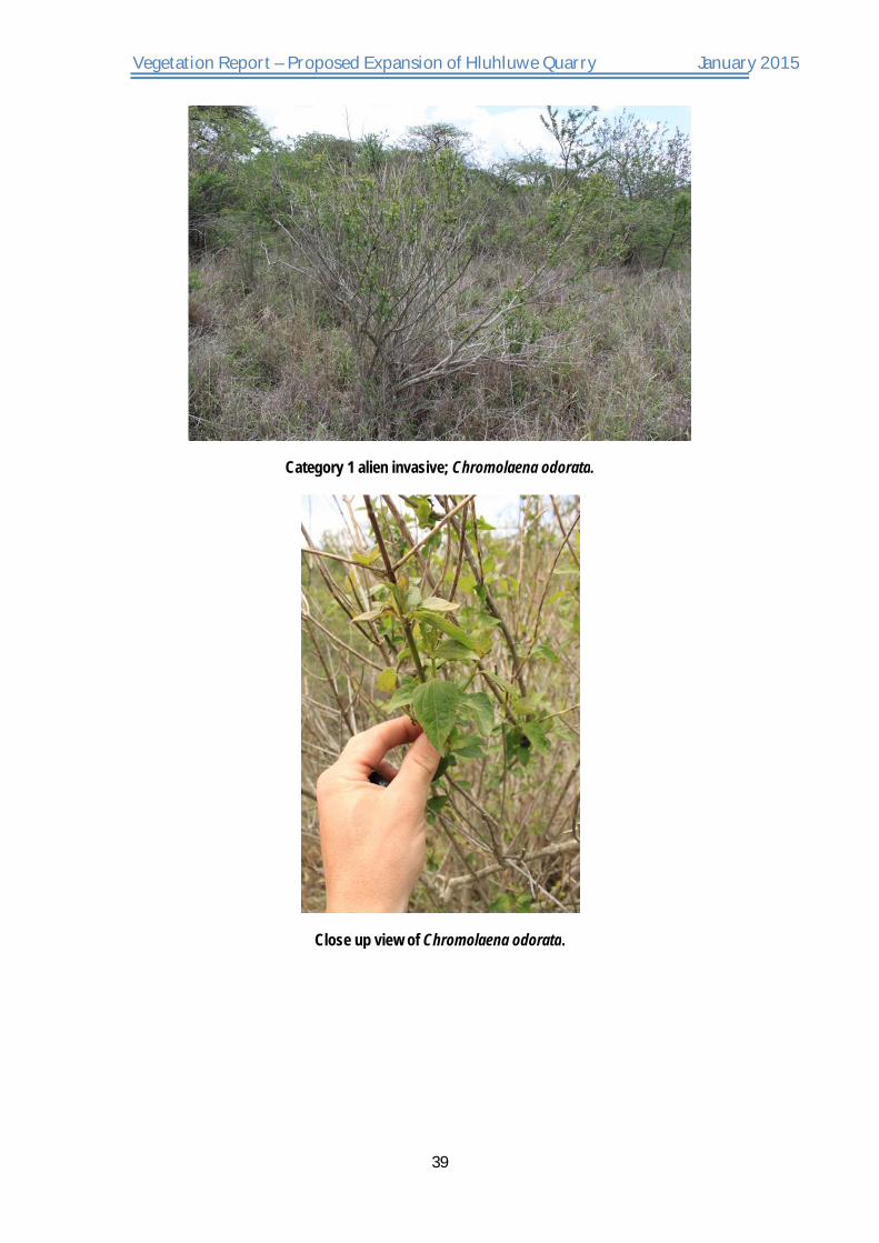
such as Themeda triandra and Panicum maximum have been replaced, to an extent, by these species mentioned. Furthermore due to the high build-up of dead grass material little new growth were noted at the time of inspection, and made plant identification of certain grass species problematic. More palatable species such as Panicum maximum, Panicum duestum, Urochloa mosambicensis etc. are associated with more shaded areas provided by patches of larger shrubs. A few game paths were noted crisscrossing the study area and were most probably used by Impala (Aepyceros melampus), Common Duiker (Sylvicapra grimmia) and occasionally Koedoe (Tragelaphus strepsiceros) moving across the property from the surrounding game farms. All three of these antelope species are browsers with impala supplementing its diet most substantially, out of the three species, with grass. The effects of browsing can be seen in Ozoroa engleri which occur in parts as a stouted form. Due to the fact that the natural vegetation is still intact and in good condition, almost no habitat is available for invading weeds and exotics. The only problematic plant species noted was Chromolaena
odorata, which is a highly aggressive Category 1 Alien Invasive, capable of invading undisturbed natural vegetated areas. If given the chance and time this species is capable of outcompeting natural species. During the survey two protected species were noted namely; Sclerocarya birrea subsp. caffra and Boscia albitrunca. These two tree species are protected according to Schedule A of the National Forest Act of 1998 (Act No. 84 of 1998).
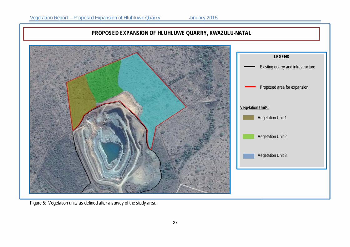
Three vegetation units were distinguished during the survey namely:
Vegetation Unit 1: Acacia tortilis subsp. heterocantha – Hyparrhenia flipendula unit
Vegetation Unit 2: Dichrostachys cinerea – Acacia tortilis unit
Vegetation Unit 3: Acacia nilotica - Hyparrhenia flipendula unit
4.2. Vegetation Unit Description These vegetation units are relative similar to each other in terms of key species composition, vegetation structure and levels of disturbances, or rather the absence thereof. Small variations between each unit, in terms of diagnostic tree species and presence/absence of other less prominent species, are mainly due to small typographical and edaphic variations. Vegetation unit 1 is mostly located on the higher crest and shoulder part of the study area whereas vegetation unit 2 is located along the middle and foot slope. The crest, middle- and foot slope has a moderate slope (0, -10.6%) in a south-easterly direction. The soils are relative loamy and

Vegetation Report – Proposed Expansion of Hluhluwe Quarry January 2015
23
gravelly. In contrast with vegetation units 1 and 2, vegetation unit 3 is located in a relative flat valley section characterized by more clayey soils.
4.2.1. Vegetation unit 1 Vegetation unit 1 has a bit more of an open thornveld structure when compared with unit 2. Both Acacia tortilis subsp. heterocantha and Dichrostachys cinerea are abundant tree species. Other Acacia species include A. natalitia, A. grandicornuta and A. nilotica although last two mentioned species were few and scanty distributed (prefers more clayey soils). Along the crest and upper part of the middle slope a few broadleaf tree- and shrub species were interspersed between the Acacia and Dichrostahys species. These species include Kigelia africana,
Ziziphus mucronata, Sclerocarya birrea subsp. caffra, Searsia gueinzii, Euclea divinorum, E.
daphnoides, E. unulata and Gymnosporia maranguensis.
4.2.2. Vegetation unit 2 This unit has a denser thicket type of structure dominated by more shrubby growth forms of D.
cinerea and A. tortilis subsp. heterocantha. The broadleaved trees are mostly absent, except for a few species of S. birrea subsp. caffra, Gymnosporia glaucophylla and S. gueinzii.
4.2.3. Vegetation unit 3 Moving from the foot slope into the flatter valley, the vegetation again becomes a bit more open dominated by medium sized Acacia trees, and especially A. nilotica which thrive in the more clayey soils of this section. Other Acacia species preferring the same conditions include; A.
grandicornuta, A. borleae as well as a few scattered species of A. xanthoploaea. As in the case of vegetation unit 1, a few broadleaved tree- and shrub species are interspersed between dominating Acacia species. Extended above the surroundings are a few large specimens of Ficus glumosa. Other broadleaved species include; S. birrea subsp. caffra, G. glaucophylla, O.
engleri, Ficus burkei, Caparis tomentosa, Phyllanthus reticulatus and Ehretia rigida. Within the far northern corner of the study area Boscia albitrunca have been noted. B. albitrunca is a protected tree. Although the Category 1 invasive alien; Chromolaena odorata is present in the other two units, their occurrence and density are low and less worrisome, on the other hand this species is a bit more threatening within vegetation unit 3 where it forms dense patches.

Vegetation Report – Proposed Expansion of Hluhluwe Quarry January 2015
24
4.3. Habitat and Species Summary
Table 3: Habitat and land use summary for Unit 1
Habitat and Land use
Substrate The crest, middle slope and upper part of foot slope consist of loamy soil which becomes moderately gravelly in certain areas. The flat valley section is more clayey.
Disturbance The proposed site consists out of largely natural, low impacted veld. There is a small section which has been cleared from vegetation and is now covered by pioneer shrubs and grasses however this comprises a very small part of the study area. Chromolaena odorata is present throughout the study area. C. odorata occurs in relative low numbers within vegetation units 1 and 2, but forms dense scattered patches within vegetation unit 3.
Species Richness
104 species recorded
2 Tree species Protected namely;
1. Boscia albitrunca
2. Sclerocarya birrea subsp. caffra
Conservation value: Medium - High:
Ecosystem function Medium: The study area provides habitat and browsing for antelope species such as Impala (Aepyceros melampus), Common Duiker (Sylvicapra grimmia) and the occasional herd of Koedoe (Tragelaphus strepsiceros). The large Ficus glumosa species provide a food source for a number of bird species suc as the Purple-crested turaco (Gallirex porphyreolopa) etc. The dense covering vegetation provide protection against possible erosion along the slopes
Other than above mentioned the study area is too small to contribute significantly to the greater
Sensitivity: Medium - High

Vegetation Report – Proposed Expansion of Hluhluwe Quarry January 2015
25
ecosystem functionality.
Need for rehabilitation Monitoring and clearing of the invasive alien; C. odorata must be done.
The removal of vegetation along the slopes might create an erosion threat. The area should be monitored regularly and if signs of erosion appear the necessary mitigation measures should be implemented.
An offset agreement is recommended, between AFRIMAT and the relevant nature conservation department (KwaZulu Department of Nature Conservation / Ezemvelo KZN Wildlife) where a selected site the equivalent size the proposed development is rehabilitated and preserved.
Agricultural potential
Medium-Low
4.4. Biodiversity Sensitivity Rating of the study area
Table 4: Biodiversity Sensitivity Rating for Unit 1.
Low (3) Medium (2) High (1)
Vegetation characteristics
Habitat diversity and Species richness 1
Presence of rare and endangered species as well as protected species.
1
Ecological function 2
Uniqueness/conservation value 2
Vegetation condition
Percentage ground cover 1
Vegetation structure 1

Vegetation Report – Proposed Expansion of Hluhluwe Quarry January 2015
26
Infestation with exotic weeds and invader plants or encroachers 2
Degree of grazing/browsing impact 2
Signs of erosion 1
Terrestrial animal characteristics
Presence of rare and endangered species 3
Sub Total 3 8 5
Total 16
Interpretation This unit can be regarded as a Medium - High Sensitive Area.
Vegetation Report – Proposed Expansion of Hluhluwe Quarry January 2015
27
Figure 5: Vegetation units as defined after a survey of the study area.
PROPOSED EXPANSION OF HLUHLUWE QUARRY, KWAZULU-NATAL
LEGEND
Existing quarry and infrastructure
Proposed area for expansion
Vegetation Units:
Vegetation Unit 1
Vegetation Unit 2
Vegetation Unit 3

Vegetation Report – Proposed Expansion of Hluhluwe Quarry January 2015
28
5. CONCLUSION & RECOMMENDATIONS
During the floral survey, observations made and the data collected, the following conclusions were made:
The typical vegetation of the study area belongs to Zululand Lowveld (SVI 23). Zululand Lowveld is regarded as Vulnerable and falls within the Black Rhino Range Ecosystem (KZN 41) which is also listed as Vulnerable. Approximately 82% of SVI 23 is regarded as natural of of which 11% is statutorily conserved mainly in the Hluhluwe-iMfolozi Park, 1% in the private Masibekela Wetland and a large area as private game farms and lodges.
The typography of the study can be described as a north-east facing slope of a hilly area and include a section of the crest, the middle slope, foot slope and a section of the low lying valley. The proposed site is situated to the north, north-east of the existing Hluhluwe Quarry. Most of the surrounding land is used for game farming. Regarding the typography of the proposed site;
The vegetation is in a natural, mostly undisturbed state. The study area had a uniform type of vegetation structure and composition and the area can be described as a relative open thornveld made up of tall grasses (Hyparrhenia species), interspersed between small trees and large shrubs, mainly Acacia species and Dichrostachys cinerea. A small number of broad leaved trees are however found on scattered in between. The dense, tall grass cover consist predominantly out of class one increasing, climax species, which is indicative of underutilization (undergrazing).
No vegetation was found in the surveyed area indicating wetland conditions or the presence of drainage lines.
A few game paths were noted crisscrossing the study area and were most probably used by Impala (Aepyceros melampus), Common Duiker (Sylvicapra grimmia) and occasionally Koedoe (Tragelaphus strepsiceros) moving across the property from the surrounding game farms.
Three main vegetation units were identified namely:
Vegetation Unit 1: Acacia tortilis subsp. heterocantha – Hyparrhenia flipendula unit

Vegetation Report – Proposed Expansion of Hluhluwe Quarry January 2015
29
Vegetation Unit 2: Dichrostachys cinerea – Acacia tortilis subsp. heterocantha
Vegetation Unit 3: Acacia nilotica - Hyparrhenia flipendula unit
Vegetation Unit 1:
Vegetation unit 1 is mostly located on the higher crest and shoulder part of the study area where the soil is more loamy and sometimes gravelly. This unit has a more open thornveld structure when compared with unit 2. Both Acacia tortilis subsp. heterocantha and Dichrostachys cinerea are abundant tree species. Along the crest and upper part of the middle slope a few broadleaf tree- and shrub species were interspersed between the Acacia and Dichrostahys species.
One protected species were noted namely; Sclerocarya birrea subsp. caffra.
The Category 1 invasive alien; Chromolaena odorata is present in this unit.
Vegetation Unit 2
This unit is located along the middle and foot slope and as in vegetation unit 1 is characterized by loamy soils with some gravelly sections. The vegetation has a more denser thicket type of structure dominated by more shrubby growth forms of D. cinerea and A. tortilis subsp. heterocantha. Less broadleaved species are found in this unit than in the other two vegetation units.
One protected species were noted namely; Sclerocarya birrea subsp. caffra.
The Category 1 invasive alien; Chromolaena odorata is present in vegetation unit.
Vegetation Unit 3
Moving from the foot slope into the flatter valley, the vegetation again becomes a bit more open dominated by medium sized Acacia trees, and especially A. nilotica.
Other Acacia species preferring the same clayey conditions include; A.
grandicornuta, A. borleae as well as a few scattered species of A. xanthoploaea. Broadleaved trees are also better represented in this unit than in the other two units.

Vegetation Report – Proposed Expansion of Hluhluwe Quarry January 2015
30
Two protected trees were found in this unit namely; Sclerocarya birrea subsp. caffra and Boscia albitrunca.
The category 1 alien invasive; Chromolaena odorata are more troublesome in this unit than in the other two units as here it forms dense patches in certain areas.
Although the study area is natural and largely un-impacted, due to the small size of the proposed development, the uniformity of habitat and vegetation structure the conservation value and ecosystem function of the study site can be regarded respectively as Medium-High and Medium.
According to the Biodiversity Sensitivity Rating, the study area is regarded a Medium -High Sensitive Area.
RECOMMENDATIONS AND PROPOSED MITIGATION MEASURES.
1. OFFSET-AGREEMENT
It is recommended that, if possible, and offset-agreement between AFRIMAT Hluhluwe and KwaZulu Department of Nature Conservation (Ezemvelo KZN Wildlife) is made where a provided site, equivalent the size of the proposed development area is rehabilitated and preserved according to recommendations and specifications from the nature conservation department.
2. Pre-Construction phase walk-through investigation for protected flora and alien invasive species.
The final footprint investigation (walkthrough) is aimed to fully inform the developer, responsible conservation authority (that will issue the relevant permits and authorisations), and contractors about:
Protected species that will be affected by the development namely; Sclerocarya birrea
subsp. caffra and Boscia albitrunca.
Location of protected plant species within the footprint area – either individually mapped (by appointed ECO) or approximate areas of occurrence.

Vegetation Report – Proposed Expansion of Hluhluwe Quarry January 2015
31
How many specimens per species will be affected – relatively accurate estimate to the nearest 50, more accurate if less than 50.
If possible, which species can be avoided and protected.
If possible which species can be successfully relocated and which and how many will be destroyed during the expansion.
Location and nature of any alien invasive species that will have to be cleared by the contractor, especially Chromolaena odorata.
Location and nature of any other significant environmental concerns, e.g. extreme gully erosion, that will need to be addressed by the contractor to prevent any unnecessary (further) degradation of the development footprint.
The above pre-construction footprint investigations will be used together with results from the ecological specialist report to draft the following:
A comprehensive alien invasive species eradication and management plan, especially for Chromolaena odorata and other possible Category 1 and 2 alien invasive species.
A report on the protected species.
Including a list of which species;
can be protected (if possible),
can be search and rescued (if possible),
will be lost due to the development.
In the case of the last two mentioned bullets (species that will be removed or destroyed), the compiled list of protected species should be used to apply for permits, issued by the relevant provincial conservation department, which is required before such activities is to commence.
3. Construction and Operational phase.
Strictly prohibit any disturbance outside the demarcated footprint area.

Vegetation Report – Proposed Expansion of Hluhluwe Quarry January 2015
32
Create designated turning areas and strictly prohibit any off-road driving or parking of vehicles and machinery outside designated areas.
Keep the unnecessarily clearing of natural vegetation to a minimum.
Clear as little indigenous vegetation as possible, aim to maintain vegetation where it will not interfere with the construction or operation of the development, rehabilitate an acceptable vegetation layer according to rehabilitation recommendations specified by the appointed ECO.
Use only species that were part of the original indigenous species composition as listed in the specialist report.
If filling material is to be used, this should be sourced from areas free of invasive species.
Topsoil (the upper 25 cm of soil) is an important natural resource; where it must be stripped, never mix it with subsoil or any other material, store and protect it separately until it can be re-applied, minimise handling of topsoil.
Reinforce portions of existing access routes or other sites that are prone to erosion, create structures or low banks to drain the access road rapidly during rainfall events, yet preventing erosion of the track and surrounding areas.
Ensure that runoff from compacted or sealed surfaces is slowed down and dispersed sufficiently to prevent accelerated erosion from being initiated (storm water and erosion management plan required).
Monitor the area regularly after larger rainfall events to determine where erosion may be initiated and then mitigate accordingly.
Prevent leakage of oil or other chemicals or any other form of pollution.
Monitor the establishment of (alien) invasive species and remove as soon as detected, whenever possible before regenerative material can be formed.

Vegetation Report – Proposed Expansion of Hluhluwe Quarry January 2015
33
6. REFERENCES Acocks, J.P.H. 1988. Veld types of South Africa. Memoirs of the Botanical Survey of South
Africa No 57. South African National Biodiversity Institute, Pretoria, South Africa.
Bromilow, C. 2010. Problem plants and alien weeds of South Africa. Briza Publications, Pretoria, RSA.
Hoffman, T. & Ashwell, A. 2001. Nature divided: Land degradation in South Africa. University of Cape Town Press, Cape Town.
Low, A.B. and Rebelo, A.G (eds). 1996. Vegetation of South Africa, Lesotho and Swaziland. Department of Environmental Affairs and Tourism, Pretoria.
Mucina and Rutherford (Eds). 2006. The Vegetation of South Africa, Lesotho and Swaziland. Strelitzia 19, South African National Botanical Institute, Pretoria.
Raimondo, D., Von Staden, L., Foden, W., Victor, J.E., Helme, N.A., Turner, R.C. Kamundi, D.A. & Manyama, P.A. (Eds.). 2009. Red list of South African plants 2009. Strelitzia 25:1-668.
U Wynberg, R. 2002. A decade of biodiversity conservation and use in South Africa: tracking progress from the Rio Earth Summit to the Johannesburg World Summit on Sustainable Development. South African Journal of Science 98: 233 – 243.NCCD: United Nations Convention to Combat Desertification, 1995.
Legislation:
The Conservation of Agricultural Resources Act, 1983 (Act No. 43 of 1983)
The Environment Conservation Act, 1989 (Act No. 73 of 1989)
The National Environment Management Act, 1998 (Act No. 107 of 1998)
The National Environmental Management Biodiversity Act, 2004. (Act 10 0f 2004). Government Gazette RSA Vol. 467, 26436, Cape Town, June 2004.
The National Environmental Management Biodiversity Act, 2004. (Act 10 0f 2004). National List of Ecosystems that are threatened and in need of protection. Government Gazette RSA Vol. 1002, 348093, Cape Town, 9 Dec 2011.
KwaZulu-Natal Nature Conservation Act (Act 28 of 1992).

Vegetation Report – Proposed Expansion of Hluhluwe Quarry January 2015
34
APPENDIXES

Vegetation Report – Proposed Expansion of Hluhluwe Quarry January 2015
35
PHOTOS OF STUDY AREA
APPENDIX A

Vegetation Report – Proposed Expansion of Hluhluwe Quarry January 2015
36
Small area cleared of vegetation. Area dominated by low growing pioneer forbs and grass species.
Vegetation unit 1: Open tornveld dominated by Acacia tortilis subsp. heterocantha (tree in the foreground), Hyparrhenia flipendula (grassy layer) and Dichrostachys cinerea (shrubs in
background).

Vegetation Report – Proposed Expansion of Hluhluwe Quarry January 2015
37
Vegetation unit 1.
Stouted growth form of Ozoroa engleri.

Vegetation Report – Proposed Expansion of Hluhluwe Quarry January 2015
38
Vegetation unit 2 has a denser ticket structure than unit 1 with shrubby Dichrostachys cinerea (shrubs in background) forming the dense structure.
Vegetation unit 2 with a few shrubs of the category 1 alien invasive Chromolaena odorata.
Vegetation Report – Proposed Expansion of Hluhluwe Quarry January 2015
39
Category 1 alien invasive; Chromolaena odorata.
Close up view of Chromolaena odorata.

Vegetation Report – Proposed Expansion of Hluhluwe Quarry January 2015
40
Example of Sclerocarya birrea subsp. caffra (a protected tree).
A view of vegetation unit 3 from the quarry. The large tree in the centre of the photo is Ficus glumosa.

Vegetation Report – Proposed Expansion of Hluhluwe Quarry January 2015
41
Patch of dense invaded Chromolaena odorata within vegetation unit 3.
The more open structure of vegetation unit 3 with Acacia nilotica (small thorny trees) being the dominant tree species

Vegetation Report – Proposed Expansion of Hluhluwe Quarry January 2015
42
SPECIES LIST OF STUDY AREA
APPENDIX B

Vegetation Report – Proposed Expansion of Hluhluwe Quarry January 2015
43
Table 5: A species list from POSA (http://posa.sanbi.org, January 2015, Grid reference: 3030BC)
Species in RED: Exotic species Species in GREEN: Endemic to RSA Species in ORANGE: Protected according to legislation Species highlighted in BLUE: Declining Status Species highlighted in GREEN: Vulnerable Status Species highlighted in ORANGE: Near Threatened Status Species highlighted in RED: Threatened Status
Species Graminoids
Aristida congesta subsp. barbicollis
Brachiaria spp. Cenchrus ciliaris
Cymbopogon caesius Cynodon dactylon
Digitaria spp. (diagonalis?) Eragrostis chloromelas
Eragrostis cilianensis
Eragrostis spp. Eragrostis superba
Heteropogon contortus Hyparrhenia anamesa
Hyparrhenia filipendula
Hyparrhenia hirta Hyperthellia dissolute
Melinis repens Panicu spp. (natalense?)
Panicum deustum Panicum maximum
Themeda triandra
Trachypogon spicatus Tragus berteronianus
Tristachya leucothrix Urochloa panicoides
Forbs Acrotome hispida Asclepias stellifera
Asystasia spp. Chaetacanthus burchellii
Chaetacanthus costatus Chamaecrista mimosoides
Crossandra zuluensis
Crotalaria spp. Cucumis zeyheri
Dalechampia capensis
Dicoma macrocephala
Dicoma macrocephala
Flaveria bidentis Gnidia spp.
Gomphrena celosioides Gossypium herbaceum
Helichrysum spp.
Hermannia depressa Hibiscus calyphyllus
Hibiscus pusillus Hibiscus trionum Indigofera spp. Jamesbrittenia spp.
Jatropha spp.
Justicia flava Leucas glabatra
Mukia maderaspatana Ocimum spp.
Pavonia burchellii
Pavonia senegalensis Pergularia daemia
Portulaca oleracea Rhynchosia miniuma
Rhynchosia totta Ruellia cordata
Senecio latifolius
Sida dregei Solanum panduriforme Stachys natalensis Tagetes minuta Tephrosia macropoda
Thunbergia neglecta Tribulus terrestris
Vernonia oligocephala
Shrubs Abrus precatorius Abutilon spp.
Gomphocarpus physocarpus
Melhania didyma Rhoicissus tridentate
Rhynchosia nitens Stachys spp.

Vegetation Report – Proposed Expansion of Hluhluwe Quarry January 2015
44
Tall shrubs Caparis tomentosa Chromolaena odorata Dichrostachys cinerea Dovyalis zeyheri
Ehretia rigida
Gardenia vokensii Gymnosporia hemipterocarpa
Gymnosporia heterophylla Gymnosporia maranguensis
Lantana rugosa
Lippia javanica Maytenus spp.
Osyris lanceolata Ozoroa engleri
Phyllanthus reticulatus Searsia gueinzii
Trees Acacia borleae Acacia grandicornuta
Acacia natalitia Acacia nilotica subsp. kraussiana
Acacia tortilis subsp. heterocantha
Acacia xanthoploea Boscia albitrunca Ficus burkei Ficus glumosa
Gymnosporia glaucophylla Schotia brachypetala
Sclerocarya birrea subsp. caffra Ziziphus micronata

Vegetation Report – Proposed Expansion of Hluhluwe Quarry January 2015
45
SPECIES LIST OBTAINED FROM POSA
APPENDIX C

Vegetation Report – Proposed Expansion of Hluhluwe Quarry January 2015
46
Table 6: A species list from POSA (http://posa.sanbi.org, January 2015, Grid reference: 2732CC)
Species in RED: Naturalized exotic species Species in GREEN: Endemic to RSA Species highlighted in BLUE: Declining Status Species highlighted in GREEN: Vulnerable Status Species highlighted in ORANGE: Near Threatened Status Species highlighted in RED: Threatened Status Crossandra fruticulosa Lindau Justicia petiolaris (Nees) T.Anderson subsp. petiolaris Ruellia cordata Thunb. Thunbergia atriplicifolia E.Mey. ex Nees Thunbergia dregeana Nees Apodolirion buchananii Baker Searsia gueinzii (Sond.) F.A.Barkley Centella asiatica (L.) Urb. Carissa bispinosa (L.) Desf. ex Brenan Aloe greatheadii Schönland var. davyana (Schönland) Glen & D.S.Hardy Aloe suffulta Reynolds Gasteria batesiana G.D.Rowley var. batesiana Flaveria bidentis (L.) Kuntze Helichrysum athrixiifolium (Kuntze) Moeser Macledium zeyheri (Sond.) S.Ortíz subsp. argyrophyllum (Oliv.) S.Ortíz Pseudognaphalium luteo-album (L.) Hilliard & B.L.Burtt Senecio citriceps Hilliard & B.L.Burtt Senecio lydenburgensis Hutch. & Burtt Davy Sarcophyte sanguinea Sparrm. subsp. sanguinea Blechnum punctulatum Sw. var. krebsii (Kunze) Sim Commiphora harveyi (Engl.) Engl. Commiphora schimperi (O.Berg) Engl. Commiphora woodii Engl. Cadaba natalensis Sond. Capparis brassii DC. Capparis fascicularis DC. var. fascicularis Capparis sepiaria L. var. citrifolia (Lam.) Toelken Capparis tomentosa Lam. Maerua cafra (DC.) Pax Gymnosporia senegalensis (Lam.) Loes. Putterlickia verrucosa (E.Mey. ex Sond.) Szyszyl. Commelina erecta L. Convolvulus farinosus L. Ipomoea carnea Jacq. subsp. fistulosa (Mart. ex Choisy) D.F.Austin Crassula expansa Dryand. subsp. fragilis (Baker) Toelken Kalanchoe rotundifolia (Haw.) Haw. Cucumis myriocarpus Naudin subsp. myriocarpus
Cyperus fastigiatus Rottb. Euclea daphnoides Hiern Euclea divinorum Hiern Euclea undulata Thunb. Dalechampia scandens L. var. natalensis (Müll.Arg.) Pax & K.Hoffm. Euphorbia grandicornis Goebel ex N.E.Br. subsp. grandicornis Jatropha natalensis Müll.Arg. Acacia luederitzii Engl. var. retinens (Sim) J.H.Ross & Brenan Acacia nilotica (L.) Willd. ex Delile subsp. kraussiana (Benth.) Brenan Acacia xanthophloea Benth. Aeschynomene micrantha DC. Albizia suluensis Gerstner Crotalaria natalensis Baker f. Crotalaria pallida Aiton var. pallida Dalbergia armata E.Mey. Dalbergia obovata E.Mey. Rhynchosia albissima Gand. Rhynchosia totta (Thunb.) DC. var. totta Senna bicapsularis (L.) Roxb. Senna didymobotrya (Fresen.) H.S.Irwin & Barneby Sesbania sesban (L.) Merr. subsp. sesban var. nubica Chiov. Vigna unguiculata (L.) Walp. subsp. unguiculata var. unguiculata Fissidens erosulus (Müll.Hal.) Paris Flagellaria guineensis Schumach. Lagarosiphon verticillifolius Oberm. Leucas capensis (Benth.) Engl. Tetradenia bainesii (N.E.Br.) Phillipson & C.F.Steyn Lemna aequinoctialis Welw. Utricularia foliosa L. Lobelia anceps L.f. Agelanthus transvaalensis (Sprague) Polhill & Wiens Cienfuegosia hildebrandtii Garcke Dombeya burgessiae Gerrard ex Harv. Hibiscus calyphyllus Cav. Hibiscus trionum L. Thespesia acutiloba (Baker f.) Exell & Mendonça Turraea obtusifolia Hochst. Cocculus hirsutus (L.) Diels Commicarpus plumbagineus (Cav.) Standl. var. plumbagineus Mystacidium aliceae Bolus

Vegetation Report – Proposed Expansion of Hluhluwe Quarry January 2015
47
Orthodontium lineare Schwägr. Oxalis smithiana Eckl. & Zeyh. Hymenocardia ulmoides Oliv. Aristida bipartita (Nees) Trin. & Rupr. Aristida congesta Roem. & Schult. subsp. barbicollis (Trin. & Rupr.) De Winter Bothriochloa insculpta (Hochst. ex A.Rich.) A.Camus Brachiaria eruciformis (Sm.) Griseb. Cenchrus ciliaris L. Chloris mossambicensis K.Schum. Chloris pycnothrix Trin. Chloris virgata Sw. Cynodon dactylon (L.) Pers. Digitaria argyrograpta (Nees) Stapf Digitaria eriantha Steud. Echinochloa colona (L.) Link Eleusine coracana (L.) Gaertn. subsp. africana (Kenn.-O'Byrne) Hilu & de Wet Eragrostis cilianensis (All.) Vignolo ex Janch. Eragrostis curvula (Schrad.) Nees Eragrostis heteromera Stapf Eragrostis racemosa (Thunb.) Steud. Eragrostis superba Peyr. Eragrostis tenuifolia (A.Rich.) Steud. Eriochloa meyeriana (Nees) Pilg. subsp. meyeriana Eustachys paspaloides (Vahl) Lanza & Mattei Heteropogon contortus (L.) Roem. & Schult. Hyparrhenia anamesa Clayton Hyparrhenia filipendula (Hochst.) Stapf var. filipendula Hyparrhenia filipendula (Hochst.) Stapf var. pilosa (Hochst.) Stapf Leptochloa eleusine (Nees) Cope & N.Snow Leptochloa fusca (L.) Kunth Lolium perenne L. Melinis repens (Willd.) Zizka subsp. repens Panicum deustum Thunb. Panicum maximum Jacq. Sehima galpinii Stent Setaria incrassata (Hochst.) Hack. Setaria sphacelata (Schumach.) Stapf & C.E.Hubb. ex M.B.Moss var. torta (Stapf) Clayton Setaria verticillata (L.) P.Beauv. Sorghum bicolor (L.) Moench subsp. arundinaceum (Desv.) de Wet & Harlan Sporobolus fimbriatus (Trin.) Nees Sporobolus ioclados (Trin.) Nees Themeda triandra Forssk. Tragus berteronianus Schult.
Urochloa mosambicensis (Hack.) Dandy Urochloa panicoides P.Beauv. Trichostomum brachydontium Bruch Ranunculus multifidus Forssk. Pavetta lanceolata Eckl. Azima tetracantha Lam. Atalaya alata (Sim) H.M.L.Forbes Sideroxylon inerme L. subsp. inerme Datura stramonium L. Stangeria eriopus (Kunze) Baill. Samolus valerandi L. Cissus rotundifolia (Forssk.) Vahl var. rotundifolia Rhoicissus revoilii Planch.