OUTLINE SERVICES REPORT - SAHRIS | SAHRA
21
OUTLINE SERVICES REPORT JOB No: J004/2013 November 2013 DRAFTED BY HJ BADENHORST VREDE TOWNSHIP DEVELOPMENT
Transcript of OUTLINE SERVICES REPORT - SAHRIS | SAHRA

OUTLINE SERVICES REPORT
JOB No: J004/2013
November 2013
DRAFTED BY HJ BADENHORST
VREDE TOWNSHIP DEVELOPMENT

CONTENTS
Chapter Description Page
1 INTRODUCTION 6
1.1 Appointment 6
1.2 Key assumptions 6
1.3 Scope of the Report 6
2 PROJECT DETAILS 7
2.1 Project Name 7
2.2 Locality 7
3 SITE DESCRIPTION 8
3.1 Zoning 8
3.2 Proposed Development 9
3.3 Topography 9
3.4 Geology 9
4 AVAILABILITY OF BULK SERVICES 12
4.1 Water 12
4.2 Sewerage 13
4.3 Access 13
4.4 Stormwater 14
5 LEVEL OF SERVICE AND DESIGN STANDARDS 15
5.1 Water Supply 15
5.2 Sanitation 15
5.3 Internal Roads 16
5.4 Stormwater 16
6 PROPOSED PROJECT PROGRAMME 17
7 CONCLUSIONS AND RECOMMENDATIONS 17

ANNEXURES
Annexure A : LOCALITY PLAN
Annexure B : PROPOSED LAYOUT PLAN
Annexure C : BULK WATER PROPOSAL
Annexure D : BULK SEWER PROPOSAL
Annexure E : CONCEPTUAL STORMWATER MANAGEMENT PLAN
Annexure F : WATERBOARD MAP OF SOUTH AFRICA

1 INTRODUCTION
1.1 Appointment
Badenhorst Konstruksie Trust has been appointed by Pula Strategic Resource Management (Pty) Ltd. to prepare an Outline Services Scheme Report for the proposed new Vrede Development. The development falls within the jurisdiction of Phumelela Municipality.
1.2 Key assumptions
Pula Strategic Resource Management (Pty) Ltd has been appointed by Phethogo
Consulting to undertake basic bulk services planning which includes this development.
This Outline Scheme Report is based on the bulk services information received from
Phumelela Municipality
1.3 Scope of the Report
The scope of this report is to identify the availability of bulk services required for the development of and design standards of the internal engineering services.
1.4 Parties Involved
Phumelela Municipality: Mr Johan Oosthuizen (Engineering Services) 073 430 1225 Simlab Geotechnical Services:
Mr Barnes J van Vuuren (Geotechnical Investigation) 083 289 3199 Phethogo Consulting (Bloemfontein): Mr P De Bie (Town Planning) 051 448 6006 Consultant: Badenhorst Konstruksie Trust
Mr HJ Badenhorst 084 619 5403
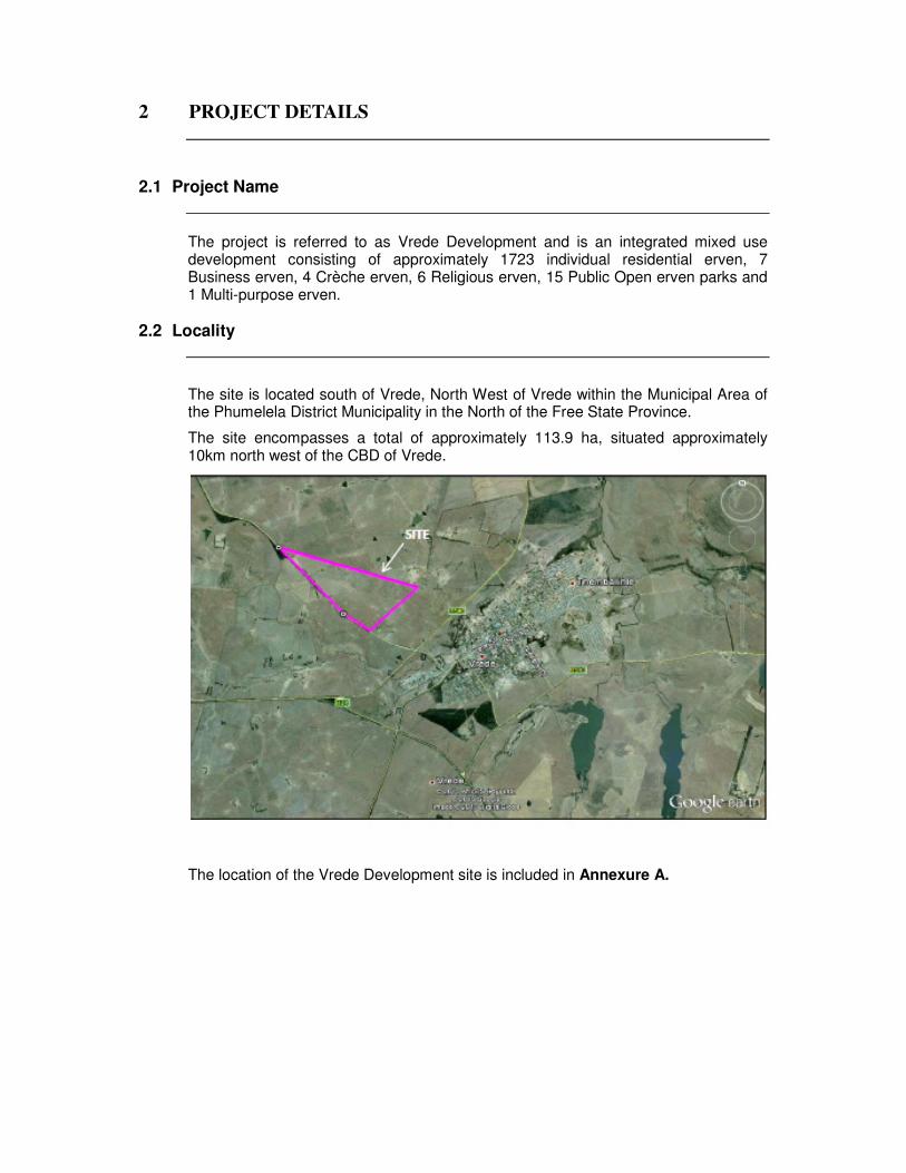
2 PROJECT DETAILS
2.1 Project Name
The project is referred to as Vrede Development and is an integrated mixed use development consisting of approximately 1723 individual residential erven, 7 Business erven, 4 Crèche erven, 6 Religious erven, 15 Public Open erven parks and 1 Multi-purpose erven.
2.2 Locality
The site is located south of Vrede, North West of Vrede within the Municipal Area of the Phumelela District Municipality in the North of the Free State Province.
The site encompasses a total of approximately 113.9 ha, situated approximately 10km north west of the CBD of Vrede.
The location of the Vrede Development site is included in Annexure A.

3 SITE DESCRIPTION
3.1 Zoning
3.1.1 Zoning
The site is presently zoned as vacant open land. The proposed land uses are contained in section 3.2.
3.1.2 Servitude’s The following servitudes affect the site:
• Eskom electrical servitude
• A Piggery 500m buffer zone
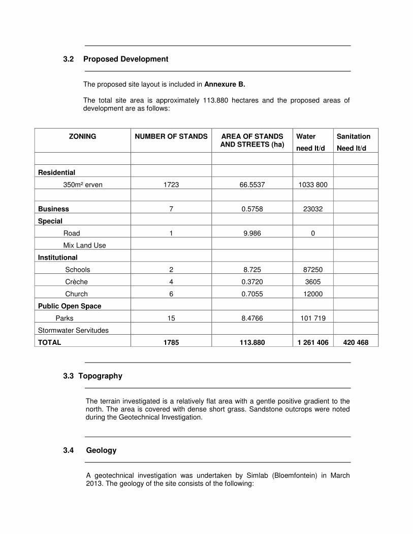
3.2 Proposed Development
The proposed site layout is included in Annexure B. The total site area is approximately 113.880 hectares and the proposed areas of development are as follows:
ZONING NUMBER OF STANDS AREA OF STANDS AND STREETS (ha)
Water
need lt/d
Sanitation
Need lt/d
Residential
350m² erven 1723 66.5537 1033 800
Business 7 0.5758 23032
Special
Road 1 9.986 0
Mix Land Use
Institutional
Schools 2 8.725 87250
Crèche 4 0.3720 3605
Church 6 0.7055 12000
Public Open Space
Parks 15 8.4766 101 719
Stormwater Servitudes
TOTAL 1785 113.880 1 261 406 420 468
3.3 Topography
The terrain investigated is a relatively flat area with a gentle positive gradient to the north. The area is covered with dense short grass. Sandstone outcrops were noted during the Geotechnical Investigation.
3.4 Geology
A geotechnical investigation was undertaken by Simlab (Bloemfontein) in March 2013. The geology of the site consists of the following:

3.4.1 Regional Geology
The site is underlain by Adelaide Formation of the Beaufort Group (Karoo Super group) consisting mainly of sandstone and mudstone. The site investigation showed that the site is mainly underlain by sandstone with mudstone encountered in several test pits with some dolerite in two test pits. Aeolian deposits also occur on the site. These refer to silts and sands transported by wind. Aeolian deposits often pertains to collapsible or compressible material. The area is classified as having a climatic N-value (after Weinert) between 2 and 5, which indicates chemical and mechanical weathering as the main forms of weathering.
3.4.2 Soil Profile Aeolian – This layer occurs over some of the site and consists of loose to medium dense silty sandy material with thickness varying between 0.3m to 0.5m with an average of 0.4m. Pebble marker – Although not generally encountered, the ferricrete found in some of the test pits may be deemed the pebble marker separating the material deemed to be transported from those considered residual. Colluvium – Some of the silty sands and sandy silts found on site seems to fit the description of a colluvium material. These are materials that has been transported by water. Colluvium soils situated on straight slopes and planes are usually well drained and exhibit a low collapse potential. Mudstone – Some definite mudstone layers have been identified during the investigation, although sandstone seems more prominent. Depending on the state of the mudrock, it can be a good founding material. Sandstone – Looking at the bedrock typically encountered during the Geotechnical Investigation, sandstone seems to be the most prevalent. Depending on the state of weathering sandstone can be a good founding material. It may even be used for the construction of road layers and backfilling. Dolerite – Although only encountered on some areas of the site, dolerite is a very good founding material which may also be used for backfilling and road construction. Dolerite is susceptible to chemical weathering and weathers down to clay, therefore the state of the dolerite needs to be carefully considered. Alluvial – Some of the clayey materials and silty materials found between 0,5m and 3,0m are considered to be alluvial in nature.
3.4.3 Ground Water and Hydrology No ground water was encountered during the investigation. Problems due to ground water seepage can be expected in places, especially during and after a very wet rainy season.

3.4.4 Geotechnical Considerations/Recommendations
Refusal at depths between 0,5m than 1,5m was often achieved on material that contained mudstone, sandstone and dolerite fractions. The clays on site display varying degrees of expansiveness. The alluvial clays have characteristics of low to medium heaving characteristics. The mudstone is generally less expansive but can sometimes also be highly expansive in a weathered state. According to the Geotechnical investigation undertaken by Simlab Geotechnical Service, no adverse conditions totally prohibiting the development of the site (Zone P as classified by the NHBRC Home Building Manual, Part 1 and 2) were observed and the site is zoned into four zones, depending on anticipated total settlement and heave movements as follows: Zone C1 Between 10 and 20mm settlement related (Not mentioned in the
report submitted by Simlab Geotechnical Services, but evident in section 8.1 page 11 and Appendix F of the said report).
Zone H1 Between 7.5mm and 15mm Heave related Zone H2 Between 15mm and 30mm Heave related Zone H3 More than 30mm Heave related NO SITE ZONING PLAN WAS SUBMITTED BY SIMLAB GEOTECHNICAL SERVICES. The site as a whole is recommended for development. Founding measures that may be considered vary from articulation to concrete raft foundations. Soil mattresses also apply but piling is less likely to be attractive from a single storey housing point of view. Machine excavation for the installation of services may encounter difficulties due to the fluctuation in the level of very dense material, mudstone bedrock, sandstone bedrock and occasional dolerite bedrock. The following recommendations are made:
• Special founding solutions must be implemented for all single and double storey structures.
• Detailed geotechnical investigations must be conducted for all high-rise structures, i.e. structures exceeding conventional double storey height.
• Phase 2 investigations must be implemented.
• Because the soils are so variably corrosive, it is recommended that non-ferrous materials be used for services piping.
In addition the following drainage measures must be implemented:
• No accumulation of surface water is to be permitted and the entire development must be properly drained.
• All trenches and excavations must be properly backfilled and compacted in 150mm thick layers and compacted to 93% of modified AASHTO density.
• Water borne reticulation must be installed.
• No trees should be planted within five meters of the line of the water bearing services.

4 AVAILABILITY OF BULK SERVICES
4.1 Water
4.1.1 Bulk Services The bulk water supply to the development will be provided by Phumelela Municipality as a water service provider from the Upper Vaal Bulk Regional Network. It is believed that the existing infrastructure can support the initial development of approximately 1785 units in Freedom Square. Vrede forms a small part of the bigger picture of Phumelela. To support the full development Phumelela Municipality depends on Upper Vaal regional Water for bulk water. The pre-planning of Upper Vaal regional water supply made projections for a prosper growth and water supply was upgraded far beyond the existing needs of Phumelela Municipality. Refer to Annexure C. Written confirmation from Upper Vaal regional water board in support of this is in the process of being obtained. No Bulk Service contributions will be needed because of the formalizing of the existing in-formalized area. This is part of the bigger picture of the government to rectify the informal housing challenge.
The water supply to the proposed development will be supplied from a 7 ML bulk water reservoir from Upper Vaal water.
The necessary Augmentation of the Upper Vaal Water network to support the proposed development is the responsibility of Vrede Municipality and is already in place.
Design criteria:
� UPVC pipes to be used starting from 90mm, 110mm,160mm, 200mm as standard sizes
� No scour and air valves would be needed for Vrede because it is already covered in the balance of the network.
� A minimum flow of 10 liters/min would be needed. � Normal clockwise closing valves to be used where no more than four (4) valves
need to be closed to isolate an area for maintenance purposes. � Water meters to be Kent 20mm connections with 15mm meters or similar. � Pre-paid meters are under consideration. � The peak factor should be used as 4. � All fire risks and other criteria according to the specifications set out by the red
book (For Human Settlements).
Balance of the design criteria is to the red book standards.

4.2 Sewerage
4.2.1 Bulk Services Vrede would be served with water born sewerage with preferably midblock sewers. The following criteria would be needed:
1. Materials used should be PVC with the minimum sizes of 160mm 2. House connections to be 110 mm. 3. Maximum manhole distances of 80 m 4. Balance of criteria to the red book standards.
The Vrede sewer works would be the receiver of the sewerage from Vrede development. The capacity of Vrede is 12 ML per day at present. At this stage the additional sewer load created by Vrede development would have little impact on the bigger Vrede picture. The additional COD load on the works would be negligible because there are no industrial stands in this development. The Vrede Sewer Works is hydraulically at design capacity but only ± 60% organically loaded. This is believed to be as a result of ingress of storm/groundwater, which is supported by the low sewage COD concentrations. Refer to Annexure D. Vrede has verbally confirmed that drainage of effluent from the above development to the Vrede Sewer works is acceptable provided that: 1. The conventional outfall sewers are re-calculated and augmented as required
to accommodate the additional flows. (Little additional capacity is created at the Vrede sewer works by the
development.) 2. No bulk services contributions would be rendered because of the formalizing
the un-formalized housing in this area. No private development is taking place at this stage but is driven by formalizing this area by thePhumelela municipality.
3. It is believed that in the short term, capacity could be increase by reducing the
amount of infiltration into the outfall sewer and hence the works.
4.3 Access
Reference should be made to the Traffic Impact Study prepared by KMA Consulting Engineers that was compiled and completed in October 2013. The new Township will gain access from an unknown street connecting to the R 546 All access ways have a minimum road reserve of 12 m unless otherwise stated, with the main access point having an rod reserve of 25 m. The road reserves will give efficient space to provide turning lanes into and out of the new development.

4.4 Stormwater
The Vrede site is located North East of Vrede, North East of Vrede CBD within the Municipal Area of the Vrede Municipality in the North of the Free State Province. There are no seasonal streams present on the site. The existing storm water is already captured in the existing open channel grid in this area. The average rainfall in Vrede is 680mm and this figure would be used in the final storm water calculations. Draining in the proposed area would be calculated to a 0.5 – 0.6 run-off factor. The pipe classes would be class 100 D underneath roads and class 50 – 75 D for other areas according to final designs. The minimum flow speed should be 1 m/s The manholes should be distant at 80 m centres maximum. Please refer to Annexure E

5 LEVEL OF SERVICE AND DESIGN STANDARDS
5.1 Water Supply
5.1.1 Internal Services
Based on the proposed development outlined in section 3.2 of the report the estimated daily demand of the development is 1.26 Ml/day and an estimated peak flow of 58 litres/sec which will have a small impact on the existing delivery.
5.1.2 Proposed Design Standards Design standards will be as per the Guidelines for Human Settlement Planning and Design and the following design standards are proposed:
• Water consumption: o Residential (zone 1) : 600l/day/erf o Residential (zone 4) : 600l/day/unit o Business/Municipal : 400l/day/100m² of GFA o Primary Schools : 10Kl/day/ha o Church : 2000l/day/erf o Crèche : 10Kl/day/ha o Clinic : 500l/day/100m² of GFA o Community Facilities : 400l/day/100m² of GFA o Parks : 12Kl/ha
• Instantaneous Demand Peak Factor: 4
• Pipe material uPVC class 12
• Min residual head during peak flow 24m
5.2 Sanitation
5.2.1 Internal Services Based on the proposed development outlined in section 3.2 of the report the estimated daily flow from the development is 0.420 Ml/day with an estimated peak flow of 13.43 lt/sec (which includes a 15% infiltration) A full water borne sanitation system is proposed connecting into the existing bulk/link sewer pipes. Materials used should be PVC with the minimum sizes of 160mm with house connections to be 110 mm. Maximum manhole distances of 80 m Balance of criteria to the red book standards.

5.2.2 Design Standards
Design standards will be as per the Guidelines for Human Settlement Planning and Design and the following design standards are proposed:
• Sewage Outflow: 200lt/erf/day
• Daily Peak Factor: 2.5
• Infiltration factor: 15%
• Minimum Velocity 0,7m/s
• Minimum gradients: 1:120 for 100mm dia. 1:200 for 150mm dia. 1:300 for 200mm dia. 1:500 for 300mm dia.
• Maximum manhole spacing: 100 metres
• Pipe material uPVC class 34 solid wall
• Pipe cover 0,6m minimum at head, 1,2m generally
• Manholes Precast concrete rings at 80 meters c/c
5.3 Internal Roads
Design standards will be as per the Guidelines for Human Settlement Planning and Design and the following design standards are proposed: It is proposed that the internal road network will consist of the following:
• 20m and 13m road reserve with a 7m and 5m surfaced width (two lanes per direction) as per layout plan. These road forms the main access through the development and linkage with adjacent development (Higher Order Mixed).
• 16m road reserves, local access routes (Medium Order Mixed).
• 12m road reserves, local access routes (Lower Order Mixed). Typical crossfalls of 3% to be constructed
5.4 Stormwater
A conceptual stormwater management plan (SWMP) for the development has been prepared and is included as Annexure E.
It is proposed that the Vrede Development be served by a conventional stormwater drainage system consisting of inlet structures and underground pipes in conjunction with roadways as well as open channels. The runoff shall be attenuated by means of stormwater detention facilities to be at least equal to pre-development peak flow rates for up to the 1 in 50 year return period storm event.

6 PROPOSED PROJECT PROGRAMME
The main project milestones for this project are as follows
• Township Application – to be submitted in November 2013
• Completion of EIA process – June 2014
7. CONCLUSIONS AND RECOMMENDATIONS
A bulk water supply sufficient to cater for the initial phases of the development is available directly from existing Upper Vaal Water infrastructure. The Phumelela Local Municipality Water Master Plan supports the full development. The existing sewage infrastructure is sufficient to cater for the initial phases of the development but plans are in place to rectify the need. Sewage from the full development to the Vrede sewer works is acceptable provided that: 1. A need for Outfall sewers upgrading is required to accommodate the additional
flows due to existing capacity in main outfall sewers and 2. Additional capacity is created at the Vrede works to accommodate the additional
flows. The development traffic can be accommodated on the existing road network provided that the recommended upgrading requirements are implemented. Adequate provision has been made within the development layout to provide storm water attenuation to cater for a 50 year flood event. It is therefore recommended that Vrede Municipality approve the application for the development of Vrede
__________________________ Henry Badenhorst (Pr. Tech (eng)
PULA Strategic Resources Management

ANNEXURE A

ANNEXURE B

ANNEXURE C
ANNEXURE D

ANNEXURE E

ANNEXURE F