VEAIN ROADS - epa.wa.gov.au
97
2 VEAIN ROADS VESTERN AUSTRALIA ALBANY HIGHWAY BEDFORDALE ifiLL SECTION DUPLICATION CONSULTATWE ENVIRONMENTAL REVIEW II ecologia 711.7:625 711(941) ECO EnvirOnflefl1tttfl 1VIRONMENTAL CONSULTANTS CopyA Library r-. 1111111 1111 i 1111111111 III II II lI liii liii -111111111111111111111111111 ItIl. liii 111111llu' 960913/1
Transcript of VEAIN ROADS - epa.wa.gov.au

2
VEAIN ROADS VESTERN AUSTRALIA
ALBANY HIGHWAY
BEDFORDALE ifiLL SECTION
DUPLICATION
CONSULTATWE ENVIRONMENTAL REVIEW
II ecologia 711.7:625 711(941) ECO EnvirOnflefl1tttfl 1VIRONMENTAL CONSULTANTS
CopyA Library
r-.
1111111 1111 i 1111111111 III II II lI liii liii -111111111111111111111111111 ItIl. liii 111111llu'
960913/1
1 H- C2&..{((e?j -LlBRARY
- cJcTloN q6c ri
I NVITA1iON30 The Environmental Protection Authority (EPA) invites people to make a submission on this proposal.
The Consultative Environmental Review (CER) proposes the duplication of the Albany Highway Bedfordale Hill Section by construction of a four lane divided highway based on duplicating the existing road.
In accordance with the Environmental Protection Act 1986 a CER has been prepared which describes this proposal and its likely effect on the environment.
The CER is available for public review for up to four (4) weeks from 8 July 1996 closing on 5 August 1996.
After receipt of comments from Government agencies and the public, the EPA will prepare an assessment report with recommendations to the Government, taking into account issues raised in public submissions.
Why write a submission?
A submission is a way to provide information, express your opinion and put forward your suggested course of action including alternative approaches.
It is useful if you can suggest ways to improve the proposal.
All submissions received by the EPA will be acknowledged. Submissions will be treated as public documents and may be quoted in full or in part in each report unless specifically marked confidential.
Submissions may be fully or partially utilised in compiling a summary of issues raised or where complex or technical issues are raised, a confidential copy of the submission (or part of it) may be sent to the proponent.
The summary of issues raised is normally included in the EPA's assessment report.
Why not join a group?
If you prefer not to write your own comments, it may be worthwhile joining a group or other groups interested in making a submission on similar issues.
Joint submissions may help to reduce the work for an individual or group while increasing the pool of ideas and information.
If you form a small group (up to 10 people) you may wish to indicate the names of all participants.
If your group is larger, please indicate how many people your submission represents.
Developing a submission
You may agree or disagree with, or comment on, the general issues discussed in the CER or with specific proposals.
It helps if you give reasons for your conclusions, supported by relevant data.
You may make an important contribution by suggesting ways to make the proposal environmentally more acceptable.

When making comments on specific proposals in the review document:
clearly state your point of view; indicate the source of your information or argument if this is applicable; suggest recommendations, safeguards or alternatives.
Points to keep in mind
By keeping the following points in mind, you will make it easier for your submission to be analysed;
attempt to list points so that the issues raised are clear. A summary of your submission is helpful;
refer each point to the appropriate section, chapter or recommendation in the review document;
if you discuss sections of the review document, keep them distinct and separate, so there is no confusion about which section you are considering;
attach any factual information you want to provide and give details of the source. Make sure your information is accurate.
Remember to include
Your name, address, date, and whether you want your submission to be confidential
THE CLOSING DATE FOR SUBMISSIONS IS: 5 AUGUST 1996.
Submissions should be addressed to:
The Chairman Environmental Protection Authority 'Westralia Square' 141 St Georges Terrace Perth W.A. 6000
Attention: Mr Todd Simms
MAiN ROADS WESTERN AUSTRALIA Bedfordale Hill Duplication CER
CONTENTS
1.0 INTRODUCTION ........................................................................................................ 1 1.1 BACKGROUND AND OBJECTIVE .............................................................. 1 1.2 PROJECT LOCATION.................................................................................. 1 1.3 THE PROPONENT....................................................................................... 1 1.4 APPROVALS PROCESS ............................................................................. 1 1.5 LEGAL FRAMEWORK ................................................................................. 4 1.6 MRWA ENVIRONMENTAL MANAGEMENT PRACTICE ............................ 4 1.7 SCOPE, PURPOSE AND STRUCTURE OFTHE CER ............................... 5
2.0 PROJECT DESCRIPTION AND JUSTIFICATION .....................................................6
2.1 PROJECT DESCRIPTION ...........................................................................6
2.2 PROJECT JUSTIFICATION .........................................................................6
2.2.1 Project History ................................................................................6
2.2.2 Need for the Proposal.....................................................................7
2.2.3 Project Benefits...............................................................................8
2.3 EVALUATION OF ALTERNATIVES .............................................................9
2.3.1 Alternative Heavy Haulage Routes .................................................9
2.3.2 Alternatives For Level Of Upgrading...............................................9
2.3.3 Selection of the Preferred Alignment ..............................................9
3.0 ROAD DESIGN PARAMETERS ............................................................................... 12 3.1 GENERAL.................................................................................................... 12 3.2 DRAINAGE ................................................................................................. 12
3.2.1 Subsurface Drainage ..................................................................... 12 3.2.2 Overland Flow ............................................................................... 12 3.2.3 Road Runoff................................................................................... 12
3.3 LAND ACQUISITION................................................................................... 13 3.4 MATERIAL SOURCING .............................................................................. 13 3.5 ROAD BATTERS ........................................................................................ 13 3.6 PUBLIC CONSULTATION.......................................................................... 14
4.0 EXISTING ENVIRONMENT ....................................................................................... 15 4.1 THE BEDFORDALE REGION .................................................................... 15 4.2 CLIMATE ..................................................................................................... 15 4.3 GEOLOGY, SOILS AND LANDFORM ......................................................... 16 4.4 HYDROLOGY............................................................................................. 17 4.5 VEGETATION AND FLORA....................................................................... 17
4.5.1 Regional Description...................................................................... 17 4.5.2 Site Description.............................................................................. 17
4.6 DIEBACK ..................................................................................................... 24 4.7 FAUNA ...................................................................................................... 24 4.8 BUNGENDORE PARK ............................................................................... 25 4.9 ABORIGINAL SITES ................................................................................... 26 4.10 CULTURAL HERITAGE ............................................................................. 26 4.11 VISUALAMENITY ....................................................................................... 26
5.0 ANTICIPATED ENVIRONMENTAL IMPACTS ......................................................... 28
5.1 GENERAL....................................................................................................28
5.2 POTENTIAL IMPACTS ON THE BIOPHYSICAL ENVIRONMENT............28
5.2.1 Bungendore Park ..........................................................................28
5.2.2 Rare Flora And Fauna ..................................................................29
5.2.3 Regionally Significant Vegetation ..................................................30
5.2.4 Vegetation Clearing ......................................................................30
ecologia

MAIN ROADS WESTERN AUSTRALIA Bedfordalo Hill Duplication CER
5.2.5 Dieback ........................................................................................ 31 5.2.6 Neerigen Brook .............................................................................. 31 5.2.7 Erosion Potential........................................................................... 31
5.3 POTENTIAL POLLUTION IMPACT FROM THE PROPOSAL.................... 32 5.3.1 Dust ................................................................................................ 32 5.3.2 Drainage ........................................................................................ 32 5.3.3 Noise ............................................................................................ 33
5.4 HERITAGE AND SOCIAL TOPICS .............................................................. 33 5.4.1 Aboriginal Heritage ....................................................................... 33 5.4.2 European Heritage......................................................................... 33 5.4.3 Visual Amenity............................................................................... 34 5.4.4 Construction Impacts ..................................................................... 34
6.0 ENVIRONMENTAL MANAGEMENT PROGRAMME ................................................ 36 6.1 AIM ...................................................................................................... 36 6.2 PRE-CONSTRUCTION PHASE .................................................................36
6.2.1 Bungendore Park.......................................................................... 36 6.2.2 Dieback.......................................................................................... 36 6.2.3 Vegetation Clearance ....................................................................37 6.2.4 Noise Amelioration.........................................................................37 6.2.5 Neerigen Brook Deviation .............................................................. 38 6.2.6 Other Topics ..................................................................................38
6.3 CONSTRUCTION PHASE.......................................................................... 39 6.3.1 Erosion...........................................................................................39 6.3.2 Dieback......................................................................................... 40 6.3.3 Vegetation Clearing ...................................................................... 41 6.3.4 Dust Control................................................................................... 42 6.3.5 Contaminants from Stormwater.................................................... 42 6.3.6 Noise Control ............................................................................... 43 6.3.7 Water Quality in Neerigen Brook................................................... 43 6.3.8 Other Topics .................................................................................. 43
6.4 POST-CONSTRUCTION PHASE................................................................ 44 6.4.1 Landscape Design Guidelines ........................................................ 44 6.4.2 Landscaping and Rehabilitation Requirements ............................. 45 6.4.3 Completion Criteria ....................................................................... 46 6.4.4 Funding......................................................................................... 48
7.0 PROPONENT COMMITMENTS ............................................................................... 49 7.1 IMPLEMENTATION OF THE ENVIRONMENTAL MANAGEMENT
PROGRAMME............................................................................................ 49 7.1.1 Implementation Schedule ............................................................. 49 7.1.2 Landscape Establishment Program............................................... 49
7.2 MONITORING REQUIREMENTS .............................................................. 49 7.2.1 Rehabilitation Monitoring .............................................................. 49
7.3 AUDITREQUIREMENTS ........................................................................... 50 7.3.1 Auditing of the Environmental Management Programme .............. 50 7.3.2 Audit of the CER ............................................................................ 50
7.4 SUMMARY OF PROPONENT COMMITMENTS ....................................... 51 7.4.1 Commitments for Audit by the DEP............................................... 51 7.4.2 Commitments for Audit by MRWA................................................ 52
8.0 SUMMARY AND CONCLUSIONS.............................................................................55
ecologia

MAIN ROADS WESTERN AUSTRALIA
Bedfordale Hill Duplication CER
STUDYTEAM ........................................................................................................57 REFERENCES ......................................................................................................58 APPENDICES ......................................................................................................60
FIGURES 1 Location of the study area...........................................................................................3 2 Cross-section of Albany Highway Duplication ............................................................ 13 3 Neerigen Brook catchment area ............................................................................... 18 4 Vegetation of the Albany Highway Bedfordale Hill Section ....................................... 20 5 Vegetation of the Albany Highway Bedfordale Hill Section ....................................... 21 6 Vegetation of the Albany Highway Bedfordale Hill Section ....................................... 22 7 Vegetation of the Albany Highway Bedfordale Hill Section ....................................... 23 8 General Dimensions of stepped cut batters .............................................................. 40
TABLES Forecast traffic volumes (vehicles per day) for Albany Highway.................................8 Schedule of Proponent Commitments ......................................................................54
APPENDICES A EPA Guidelines for Preparation of the CER..............................................................60 B Plans of Road Alignment and Land Acquisition Requirements.................................65 C Summary of Public Consultation Programme .............................................................72 D Vegetation List for the Albany Highway Bedfordale Hill Section ..............................77 E Suggested Revegetation Flora Species List .............................................................79
ecologia

'V
MAIN ROADS WESTERN AUSTRALIA Bedfordale Hill Duplication CER
SUMMARY
BACKGROUND AND OBJECTIVE
The Albany Highway Duplication proposed by Main Roads Western Australia (MRWA) for Bedfordale Hill in the City of Armadale occurs between Straight Line Kilometre (SLK) 27.57 and SLK 35.19. The proposal comprises the construction of a four lane dual carriageway by duplication of Albany Highway between the end of the existing dual carriageway and the Road Train Assembly Area.
This Consultative Environmental Review (CER) aims to identify the potential environmental impacts which may arise from the new works and to recommend methods of reducing their effect on the environment. The objective of the CER is to provide the Department of Environmental Protection (DEP) and the Environmental Protection Authority with information about the proposal as a basis for its assessment of the project, and to inform interested parties about the project so that they are in a position to contribute to the environmental impact assessment process if they so wish.
PROJECT DESCRIPTION AND JUSTIFICATION
Project Description The 7.6 km duplication will be constructed within land either already acquired for the purpose, or within an area previously identified within the Metropolitan Region Scheme as being required for road widening. The second carriageway will generally be constructed on the western side of the existing carriageway, except where topographical and environmental constraints require otherwise.
The scope of works includes road reconstruction, construction of a dual use path (DUP), a DUP underpass beneath Albany Highway, amended intersections and median breaks, changes to public utilities and water pipes, fully contained road drainage, and landscaping compatible with the existing character of Albany Highway.
Project JustificatIon The Bedfordale Hill Section of Albany Highway has been the subject of ongoing planning and design. The Albany Highway Planning Study for Duplication Options at Bedfordale Hill examined three alternatives:
four lane undivided road;
four lane divided road; and
retention of current single carriageway.
This planning study found that the level of service of the existing road was approaching the unstable flow where most drivers are severely restricted from selecting their desired speed; any small increases in traffic flow would therefore cause operational problems. The recommendation of this study was that a four lane divided carriageway option be adopted to improve driver safety and create a more pleasing environment.
A traffic study was undertaken to project future traffic volumes between now and the year 2021. The projections show that over the next 25 years traffic volumes are expected to approximately double due to increased demand in the local area, as well as increased travel between the Metropolitan Area and the South-west. Existing traffic flow and safety problems exist in the study area, and these will be exacerbated by an increase in traffic volumes. The current proposal has been developed in response to these factors.
Project Benefits The construction of a four lane divided road will provide improvements in aspects of public safety and transport efficiency. Additional benefits of the proposal include:
ecologia

V MAIN ROADS WESTERN AUSTRALIA
Bedfordale Hill Duplication CER
a high level of service for-the road user;
geometric improvements resulting in a safer and more pleasing road environment;
avoidance of the cost of constructing passing lanes as an interim measure;
economic benefits resulting from laden long vehicles being allowed to travel down, as well as up, Bedfordale Hill; and
alleviation of uncertainty over future property acquisition requirements.
Evaluation Of Alternatives One alternative route for heavy haulage has been considered by MRWA as an alternative to upgrading Albany Highway to four lanes through Bedfordale. The route comprised the Jarrahdale Road, between Albany Highway and the Armadale-Bunbury Road, and then from that intersection up to Armadale Road. The alternative route consists of 39 km, and would cost in the order of 8 - 10 times the duplication proposal outlined in this CER.
Based on traffic figures, the volume of traffic requiring an upgrade will occur on the Bedfordale Hill Section of Albany Highway within three to 12 years. The interim measure of constructing passing lanes could be utilised to maintain current operating conditions. However, the predicted continual increase in traffic will require the level of duplication currently proposed.
The option for a four-lane undivided road provided a cheaper solution than a divided road. The choice of creating a divided road is based upon its greater safety and more pleasing road environment.
No alteration to the existing situation will result in increasing traffic volumes accompanied by a decrease in the level of service provided by the roadway. The outcome of this scenario is the likelihood of an increased rate of accidents, including potential for fatalities.
Selection of the Preferred Alignment The process of developing the four lane divided road proposal for the Albany Highway Bedfordale Hill Section duplication, the subject of this CER, has been based upon a number of objectives. These are:
minimisation of intrusion into Bungendore Park;
avoiding where possible significant vegetation and buildings adjacent to the existing road;
minimisation of impact on Neerigen Brook; and
minimising requirements for land acquisition.
ROAD DESIGN PARAMETERS
General The Bedfordale Hill Section of the Albany Highway duplication is planned to be constructed as a kerbed four lane, median separated dual carriageway. The road is to be bordered on the western side with a dedicated DUP for cyclists and pedestrians. The horizontal and vertical alignments of the duplication are to meet the engineering requirements for a design speed of 80 km/hour (SLK 27.57 to 32.2) and 90 km/hour (SLK 32.2 to 3519).
Median openings are required to provide access to local roads and properties from Albany Highway. A total of 13 median openings are proposed, occurring on average approximately every 600 rn.
Drainage To accommodate subsurlace waterf low in the area, it will be necessary to incorporate subsurface drainage into the design and construction of cut sections of the road. Subsurface drainage is to be collected and discharged into culverts.
ecologia

vi MAIN ROADS WESTERN A USTRAUA
Bedfordale Hill Duplication CER
Catchment areas and water flows have been determined, and culvert requirements calculated on a 20 year design rainfall intensity. Culvert locations, inlet and outlet levels have been incorporated into the road design. The design incorporates existing culverts, and provides additional culverts along the length of the duplication. The culverts will discharge into Neerigen Brook at regular intervals.
Two options have been identified in relation to road runoff. The preferred option is that of collection and containment, with an additional option suggested by the City of Armadale for whole of site dispersal for runoff.
EXISTING ENVIRONMENT
General Albany Highway climbs into the Darling Scarp via a re-entrant valley and reaches the crest around Bedfordale. The existing road is contained within a road reserve 25 to 40 metres wide. The reserve is bordered on the north and south by residential and agricultural holdings, as well as State conservation reserves. In addition, Neerigen Brook runs along the northern boundary of the reserve for almost the entire length of the proposed widening.
The immediate landscape surrounding the proposed road works is characterised by a semi-rural atmosphere because of the large rural blocks, orchards, a brook and period farm houses. The definition of the road reserve is achieved by large stands of both exotic and indigenous trees lining both the road verge and road reserve boundary.
The area contains a number of orchards and vineyards, semi-rural paddocks, hobby farms, commercial premises, pastures concerned with horse agistment and racing, and a Road Train Assembly Area. In addition the alignment also passes adjacent to Bungendore Park, and enters into State Forest to the east of the Road Train Assembly Area.
The main features of the study area are discussed below.
Hydrology For the entire length of the proposed works, Neerigen Brook traverses the reserve on the northern side of Albany Highway. This brook originates in the vicinity of Springfield and Dmietrieff Roads and has some minor tributaries near Armadale before ending in Wungong Brook near Lake Road 3 km west of Armadale. The brook is used as a source of potable water by some residents and as such is of special concern. Neerigen Brook has a catchment of 10 km2 between the Road Train Assembly Area and Bedfordale Hill Road.
With the exception of some minor gullies which carry concentrated stormwater from the local road system, the remainder of the project site is well drained with water shedding evenly off the slopes.
Vegetation The Bedfordale area lies within the Darling Botanical District System in the Dale Subdistrict. The Darling System encompasses the northern Jarrah forest which is associated with the laterite-capped plateau. Prior to widespread clearing and colonisation, the study area was mainly Jarrah forest with river gums and paperbarks occurring in wetter areas. Using the Beard-Webb Formula the intact native vegetation of the Bedfordale study area is classified as Eucalyptus (jarrah and marri) medium trees (10 - 30 m tall) with a mid to dense canopy.
Fauna Limited information is available on fauna of the Darling Scarp, due to the lack of comprehensive biological surveys undertaken. There are no known species in the Darling Ranges that are restricted to that area, however marked changes in abundance and distribution of fauna populations, including local extinctions of mammal species, and severe reductions in population size of bird and reptile species has occurred.
ecologia

VII MAIN ROADS WESTERN AUSTRALIA
Bodfordale Hill Dupllcat!on CER
In the areas of the proposed duplication, there are no species with a declared conservation status. However Southern Brown Bandicoots Isoodon obesulus are known to exist in Bungendore Park.
Bungendore Park Bungendore Park is situated to the south of Albany Highway, is an 'A' Class Reserve (tA4561), falls within System 6 Area M80, and is a component of the proposed Darling Regional Park.
Bungendore Park also contains the Southern Brown Bandicoot Isoodon obesulus. The Bandicoot is considered to be of State conservation significance, by virtue of the current Schedule 1 Wildlife Conservation Act 1950 status. Any removal of habitat that is of significance to the Bandicoot would be detrimental to the population in the area. Bungendore park also has two orchid species within it's boundaries that are listed on the Declared Rare and Priority Flora List (Atkins, 1995). These are the Dwarf Bee Orchid Diuris micrantha and the Star Orchid Thelymitra stellata.
Visual Amenity As a component of the Darling Range Regional Park planning study, a visual resource assessment of the Darling Range sub-region was undertaken. The study area falls into the Darling Plateau Landscape Character Type, Sub Type: Darling Upland. The alignment of Albany Highway falls within a category of high scenic quality from the commencement of the study area (Triton Crescent) to the point at where the Highway diverges from the Bungendore Park boundary. The remainder of the alignment subject to the duplication proposal is classified as having moderate scenic quality. The alignment has a High Priority Landscape Management Zone categorisation, the objective of which is one of maximum retention of existing Landscape Character. Under this classification, any visual alterations should be designed to have a minimum visual impact as far as practical to an observer after a period of five years from the initial alteration.
PUBLIC CONSULTATION PROGRAMME
A major public consultation programme has been undertaken to understand the community concerns and to address those concerns within the project design wherever possible. The programme has included:
Consultation on the Concept Plan;
Consultation on the Preliminary Design; and
Establishment of a Community Liaison Group.
The outcome and recommendations of the consultation programme concluded that there was wide community support for the project, with a number of specific issues requiring resolution through the planning process.
ANTICIPATED ENVIRONMENTAL IMPACTS
As the route traverses a near metropolitan semi-rural landscape within the Darling Scarp the potential exists for the proposed roadworks to impact on both the biophysical and social environment.
Key topics in consideration of the project have been identified as:
impact to Bungendore Park, an 'A' Class Reserve and System 6 area.
the presence of Neerigen Brook adjacent to the road reserve. The brook is used as a potable water source by some local residents and contains significant visual and aesthetic values to the local community;
requirement for diversion of sections of Neerigen Brook, with potential for raising sediment loads and therefore impacting on water quality;
ecologia

MAIN ROADS WESTERN A USTRAUA Bedfordale Hill Dupilcation CER
stands of remnant native vegetation occurring within the road reserve;
potential for introduction, or spread of, dieback through the study area; and
raised no!se levels for some residents adjacent to the proposed alignment.
ENVIRONMENTAL MANAGEMENT PROGRAMME
The aim of the Environmental Management Programme is to document the methods by which the potential project impacts can be minimised. The recommendations for management of the road construction project are separated into three distinct phases, these being:
Pre-constructiori Phase
Construction Phase
Post-construction Phase
Aspects of the project which require management strategies include:
Pre-construction Phase
Key Topics Bungendore Park Dieback Vegetation Clearance Noise Amelioration Neerigen Brook Deviation
Other Topics Project Induction Land Acquisition Aboriginal Heritage Sites Cultural Heritage Sites
ConstructIon Phase
Key Topics Erosion/Siltation Control Dieback Procedures Vegetation Clearing Dust Control Contaminants from Stormwater Noise Control Water Quality in Neerigen Brook
Other Topics Traffic Management Aboriginal Heritage Sites Services Relocation Chemical Spillage Hardstand Areas Weed Control
ecologia

ix MAIN ROADS WESTERN AUSTRALIA
Bdforda!o Hill Dupilcation CER
Post-Construction Phase Landscape Design Guidelines Landscaping and Rehabilitation Requirements Completion Criteria Funding
PROPONENT COMMITMENTS
MRWA Metropolitan Division is responsible for the construction of the Albany Highway Bedfordale Hill Section Duplication in an environmentally and socially responsible manner. MRWA is committed to implementing the environmental management procedures detailed in this document. All aspects of the management programme will be complied with throughout the design and construction of the project, according to the phase in which they occur.
In addition to implementation of the Environmental Management Programme, MRWA will undertake action in the following areas:
Implementation Schedule The project is scheduled to be constructed in two stages between December and May 1996/97, and between November 1 and May 31 in 1997/98. The commencement of construction is subject to attainment of all necessary approvals.
Pre-construction management recommendations are to be carried out prior to commencement of site works. Strategies documented for the construction phase are to apply between the dates specified, and apply to both stages of construction. Post-construction requirements are to apply from June 1, 1997 for Stage 1 of construction and be ongoing, and from June 1, 1998 for Stage 2.
Monitoring and reporting requirements for the landscaping and rehabilitation aspects of the project may be separated for the two phases.
Landscape Establishment Program A Landscape Establishment Program with an appropriate budget will be included as part of the original works program and should be over and above the regular maintenance procedures undertaken by the Division. It should include the following:
a semi-annual works or establishment program for the first five years after construction;
measures which address the problems and suggested solutions as outlined in the Post Construction Reports; and
a record of the procedures employed and their success rate.
Rehabilitation Monitoring Post Construction Monitoring of the works should be carried out by a biological scientist, botanist or landscape architect twice a year for at least three years. The monitoring is to include:
site visits every six months;
a Post Construction Report detailing the status of the project at the time of the site visit; and
a photographic record should be made at the time of the site visit.
Auditing of the Environmental Management Programme The EMP documents completion criteria for landscaping and rehabilitation. In order to determine that the set completion criteria have been satisfied requires a monitoring and audit programme. MRWA utilise Environmental Assessment and Management Plans (EAMP) to implement environmental management
ecologia

x MAIN ROADS WESTERN AUSTRALIA
Bedfordale Hill Duplication CER
recommendations for road projects. An Environmental Assessment and Draft Management Plan currently exists for this project, and this will be amended to be consistent with the outcome of the formal environmental assessment process.
The final EAMP will include a commitment and implementation schedule similar to that produced through the environmental assessment process. This schedule will form a component of the contract for the Works Contractor and will be subject to audit through the Landscape and Environment Branch of MRWA.
Audit of the CER MRWA will undertake auditing of the Conditions of the Minister for the Environment on the Albany Highway Bedfordale Hill Section Duplication project CER assessment. Reporting will occur at the completion of each major phase of the project, or an annual basis where any one phase extends over more than 12 months.
CONCLUSION
In conclusion, the planning and consultation for this project has been extensive, and a detail environmental management strategy developed to mitigate impacts. With implementation of the project as documented within this CER there should be no long term negative impact on the site, nor its inhabitants.
A summary of the key issues and management strategies for the project is provided in the following table.
ecologia

Summary of key topics
Category Topics of Concern Present Status Proposed Action Proposed Management Predicted Outcome
Biophysical System 6 Area M80 Bungendore Park is adjacent to Ingress into Bungendore Usé of 1:3 batter slopes Successful rehabilitation Albany Highway and is not currently Park boundaries due to proposed in order to provide of the Park boundary affected by the roadway. requirement for a suitable slope for within 5 years.
earthworks for batter rehabilitation purposes. slopes. lmplementation of
rehabilitation programme.
Rare flora and fauna No rare flora or fauna have been Priority flora search to be Management strategy Dependent on results of recorded in the road corridor. Two undertaken in the area of developed according to the DRF search. Minimise species of Declared Rare Flora and impact of Bungendore results of the flora search. impact on any rare flora. one Schedule 1 fauna species are Park during Spring 1996. No impact on rare fauna found within Bungendore Park. species.
Remnant vegetation Remnant vegetation consists of Clearing of vegetation Designation of limit of works Vegetation clearance Jarrah and Marri woodland in the within area required for for clearance according to limited to that vegetation current road reserve of the study road construction and limit of site disturbance occurring within direct area. Remnant vegetation is not earthworks for batter required for earthworks. impact area of road and considered to be of regional slopes. earthworks. significance.
Erosion Minor erosion of road batters evident Construction of batters Step cutting of batters and A rehabilitated and stable in some locations, and incorporation into use of interceptor drains to surface in all areas of
drainage system to reduce stormwater runoff roadworks. minimise erosion risk. Implementation of
rehabilitation measures as soon as practical following completion or roadworks
Dieback Study area classified as Not Dieback analysis in study Dieback management Prevention of spread of Effectively Quarantined in reference area to confirm any strategy to be developed dieback either into, from to presence of dieback. presence and location of according to results of or throughout the study
dieback within the works dieback survey. Based upon area. area. exclusion from the site and
containment within the site, and in accordance with CALM policy and procedures.
ecologia

Summary of key topics
Category Topics of Concern Present Status Proposed Action Proposed Management Predicted Outcome
Vegetation Clearing Vegetation clearing has occurred Clearing of vegetation Designation of limit of works Vegetation clearance historically for development of semi- within area required for for clearance according to limited to that vegetation rural and residential land, and for road construction and limit of site disturbance occurring within direct road construction. earthworks for batter required for earthworks. impact area of road and
slopes. earthworks.
Water Supply Neerigen Brook currently with Construction requiring two Diversion timed to occur over Minor interruptions to constant water flow. section of the Brook to be summer when
'flow is at water flow during
diverted, lowest. Relocated channel to connection of diverted be fully constructed prior to channel to existing diversion of water occurring, channel.
Pollution Dust Control Not an issue under normal Clearing and roadworks Spraying with potable water Limited amount of dust conditions. having potential to while construction activities generation during
generate dust. are occurring. earthworks. No nuisance Use of paper mulch if dust caused to residents, and
nuisance occurs causing no detrimental impact on complaints from residents. vegetation.
Contaminants from Stormwater currently drains directly Separation of overland Road runoff to be channelled Prevention of road Stormwater from the road, and enters Neerigen flow from road runoff by to a discharge point below contaminants entering -Water quality in Brook. Any contaminants from the separating these Bedfordale Hill Road. Neerigen Brook prior to it Neerigen Brook road surface can therefore enter the components of the Water quality protected becoming a drainage
drainage system. drainage system. during construction to prevent reserve. Possible erosion during rainfall events improvement in water in the construction phase. quality where separation
of drainage occurs.
Noise The existing traffic flow is resulting in Noise amelioration Noise walls in front of Noise impact on the a noise level of 64 dB(A) (L10 18 measures for three affected properties will be three properties will be Hour) at 20 metres from the road residences which will be investigated during the design mitigated by use of edge. subject to noise increases phase for appropriate barriers.
above MRWA criteria, construction materials.
ecologia

Summary of key topics
Category Topics of Concern Present Status Proposed Action Proposed Management Predicted Outcome
Hydrology of Neerigen Neerigen Brook runs adjacent to Neerigen Brook to Channel parameters of Hydrology of Neerigen Brook Albany Highway in the study area, experience diversion in relocated channel bed to be Brook maintained at pre-
and in the drainage channel or a 10 two locations; sections of derived from existing channel construction levels. km 2 catchment. The Brook is used 250 rn and 80 m to be characteristics. Minor reduction in as a water source by local residents. diverted. Design and construction to volume due to removal of
minimise erosion potential road runoff from the and siltation during existing drainage pattern. construction.
Environmental values Neerigen Brook supports local Neerigen Brook to Volume of road runoff Neerigen Brook to be of Neerigen Brook. vegetation and serves as an experience diversion in removed from Neerigen rehabilitated to reflect its
aesthetic feature of the study area. two locations; sections of Brook catchment negligible, current aesthetic and 250 m and 80 m to be Diversion to be managed to environmental values. diverted, minimise siltation. Some alteration to the
Rehabiliation to restore the vegetation expected aesthetic qualitites of the along the diverted brook. channel areas.
ecologia

MAIN Rows WESTERN AUSTRALIA Bedfordalo Hill Duplication CER
1.0 INTRODUCTION
1.1 BACKGROUND AND OBJECTIVE
The Albany Highway Duplication proposed by Main Roads Western Australia (MRWA) for Bedfordale Hill in the City of Armadale occurs between Straight Line Kilometre (SLK) 27.57 and SLK 35.19. The proposal comprises the construction of a four lane dual carriageway by duplication of Albany Highway between the end of the existing dual carriageway and the Road Train Assembly Area.
The project is to be constructed in two stages; over summer and autumn of 1996/97, and between November 1 and May 31,1997/98. Rehabilitation and landscaping will be timed to coincide with the construction schedule.
The goals and benefits of the proposal are:
to provide a safer route for traffic along Albany Highway in the region of Bedfordale Hill; and
to retain or improve existing visual and environmental qualities of the area.
This Consultative Environmental Review (CER) aims to identify the environmental impacts which may arise from the new works and to recommend methods of reducing their effect on the environment. The report also incorporates the results of an acoustic assessment (Herring Storer Acoustics, 1996), the recommendations from a landscape design concept (Hames Sharley, 1996), and an Environmental Assessment and Management Plan specifically prepared for the Bedfordale Hill Duplication project
(ecologia, 1996).
The CER has been prepared in accordance with the guidelines issued by the Environmental Protection Authority (EPA) for the project. The guidelines are included in Appendix A.
1.2 PROJECT LOCATION
Bedfordale is located on the Darling Scarp approximately 5 km to the east of Armadale, 35 km south-east of Perth, close to the junction of the Albany Highway and the South-Western Highway. It lies 40 km inland and Bedfordale Hill reaches a height of 300 m.
The proposed roadworks extend between SLK 27.57 (Triton Crescent) and SLK 35.19 (Road Train Assembly Area) on Albany Highway in the vicinity of Bedfordale Hill (Figure 1).
1.3 THE PROPONENT
The proponent for the Albany Highway Bedfordale Hill Section Duplication is:
Main Roads Western Australia Metropolitan & Traffic Operations 2 Adams Drive Welshpool WA 6106
1.4 APPROVALS PROCESS
The EPA is required to assess all development proposals which may have a significant environmental effect. In this instance, the EPA has decided to formally assess the proposal pursuant to the provisions of Part IV of the Environmental Protection Act 1986.
ecologia

2
MAIN R OADS WESTERN A US1RALIA Bedfordale Hill Duplication CER
The EPA's formal environmental impact assessment process allows members of the public to obtain details of the proposal being assessed and to comment on any matters of interest or concern to them. It also enables relevant Government authorities to consider the environmental and social implications of the proposal and provide comments as appropriate to the EPA. In assessing the proposal, the EPA considers all comments received.
In setting the level of formal environmental impact assessment for the proposed Albany Highway Bedfordale Hill Section Duplication at CER, the EPA has required that the document be released for a four (4) week public review period during which time any interested individual, community group or organisation, or Government agency can peruse the document and lodge a submission on the proposal with the EPA. This CER is a public document and is part of the statutory public environmental impact assessment process established by the Environmental Protection Act 1986.
Following completion of the public review period and receipt of public submissions, the EPA will complete its assessment of the proposal and submit its report to the Minister for the Environment. The EPA's report to the Minister provides advice to the State Government about the environmental acceptability of the proposal.
The Minister will release the EPA's Assessment Report for a two (2) week period during which the public can scrutinise the conclusions and, if considered warranted, appeal to the Minister against the recommendations made about the proposal. The Minister for the Environment will assess any appeals received and ultimately determine whether or not the proposal can proceed. If the Minister determines that the proposal can proceed, legally binding conditions dictating the environmental requirements with which the proponents have to comply will be set pursuant to Section 45 of the Environmental Protection Act 1986.
Thus, in order for the proposed Albany Highway Bedfordale Hill Section Duplication project to proceed, the following statutory requirements need to be completed:
a CER to be prepared and submitted to the Department of Environmental Protection (DEP) (which must be satisfied that the document contains sufficient information on, and responses to, topics and objectives identified in the project guidelines (Appendix A) before it can be released for public review);
release of the CER for a four (4) week public review period;
DEP prepare a summary of submissions received from Government Agencies and members of the public;
proponents provide the DEP with written responses to all issues raised in submissions received during the public review period;
the EPA provides its advice to Government on the proposal through its Assessment Report to the Minister for the Environment;
the Minister determines any appeals against the EPA's Report and if the proposal is regarded as environmentally acceptable, sets legally binding conditions on the proponent.
the project is commenced according to the Ministerial Conditions and Proponent Commitments set out in the Statement that a Proposal may be Implemented (Pursuant to the Provisions of the Environmental Protection Act 1986).
ecologia

PERT J.F.,(
INDIAN
OCeAN .--~p
çoO
CrOSS
- CURRENT ALIGNMENT ALBANY HIGHWAY
PROPOSED FOUR LANE DIVIDED ROAD
I 00
-J I I
I 1)
O 2km
Scale 1:40,000
ALBANY HIGHWAY BEOFORDALE HILL DUPLICATION
LOCALITY PLAN
Figure 1
4
MAIN ROADS WESTERN A USTRALIA
Bedfordale Hill Duplication CER
1.5 LEGAL FRAMEWORK
In addition to satisfying the provisions of the Environmental Protection Act 1986, requirements under the following legislation relevant to the proposal have been or have to be considered:
Heritaae
Local
fl1; Ie1Ii
1.6 MRWA ENVIRONMENTAL MANAGEMENT PRACTICE
MRWA in co-operation with Local Government Authorities develops and manages the State's road network. This role includes responsibility for road planning, road construction, maintenance, and management of road reserves associated with State roads.
MRWA has developed policies and procedures for environmental assessment and management of its activities. This includes an Environmental Management Manual (MRWA, 1992) which documents:
(I) an Environmental Management Strategy which covers:
an Environmental Code of Practice;
Procedures For Environmental Assessment And Management; and
Environmental Education and Training.
(ii) guidelines for the consideration of significant environmental issues in roadworks, which covers a range of issues including:
Aboriginal sites;
Aesthetics;
Bicycle and pedestrian facilities;
Biological surveys;
Clearing of vegetation;
Cultural heritage places;
ecologia

5
MAIN R OADS WESTERN A USTRALIA
Bedfordale Hill Duplication CER
Dieback;
Drainage and hydrology;
Noise;
Rare flora and fauna;
Rehabilitation; and
Social effects.
1.7 SCOPE, PURPOSE AND STRUCTURE OF THE CER
The objective of the CER is to provide the EPA with information about the proposal as a basis for its assessment of the project, and to inform interested parties about the project so that they are in a position to contribute to the environmental impact assessment process if they so wish.
This CER is the second document produced as part of the process of evaluating the environmental acceptability of this proposal. The first of these documents entitled an Environmental Assessment and Management Plan (EAMP) assessed impacts on the biological and human environments within the overall project area and produced management strategies to minimise any predicted impacts (ecologia, 1996). This report was produced according to the requirements of the MRWA Environmental Management Policy for road projects, as documented in the MRWA Environmental Management Manual (MRWA, 1992).
This CER is based on the material presented in the EAMP, and from other specialist studies undertaken for the project, including an extensive community consultation programme.
The structure of the CER is as follows:
Chapter 1 provides a background to the project and the environmental assessment process to gain project approval.
Chapter 2 of the CER describes the scope of the project, and the justification for the proposal to proceed, while Chapter 3 details the design aspects of the proposal, and specialist studies undertaken to contribute to the engineering, planning and detailed design of the duplication project.
Chapter 4 describes the existing biological and human environments within the project area.
Chapter 5 canvasses predicted environmental impacts associated with the proposed route, while Chapter 6 details the environmental management plan developed to mitigate these impacts.
Chapter 7 discusses implementation requirements for the Environmental Management Plan, and commitments made by the proponent to ensure the effectiveness of impact amelioration techniques.
Chapter 8 forms the conclusion to the CER.
ecologia

MAIN R ons WESTERN A USTRALIA Bedfordale Hill Duplication CER
2.0 PROJECT DESCRIPTION AND JUSTIFICATION
2.1 PROJECT DESCRIPTION
The 7.6 km duplication will be constructed within land either already acquired for the purpose, or within an area previously identified within the Metropolitan Region Scheme as being required for road widening.
The second carriageway will generally be constructed on the western side of the existing carriageway, except where topographical and environmental constraints require otherwise. The new carriageway would be created from cut sections of the hillside. Fill will be used to improve vertical geometry in substandard sections, and to construct the second carriageway in selected locations.
Stabilised embankments are to be used within the verge to match the road level with surrounding natural land levels. Retaining walls have been proposed in four locations to avoid the need for land acquisition at these sites.
The scope of works comprises:
Reconstruction of the existing two lanes into a four lane divided highway;
A dual use path (DUP) along the western side of the highway south of Bedfordale Hill Road and extending to Springfield Road, and on local roads to Topaz Court;
a DUP underpass beneath the highway between Topaz Court and Triton Crescent;
a footpath along the eastern side of the highway north of Bedfordale Hill Road to Triton Crescent;
at-grade intersections at Waterwheel Road, Admiral Road, Springfield Road and Dmitrieff Road;
amended intersection at Bedfordale Hill Road to provide for a left turn only to Albany Highway and right turn only from Albany Highway;
median breaks at 9 mid-block locations to provide for U-turning traffic, in addition to median breaks at intersections;
landscaping compatible with the existing character of Albany Highway and incorporating an entry statement to Armadale at the bottom of the Hill;
(iv) provision of highway lighting at intersections;
changes to public utilities as required for the duplication of the Highway;
conduits for private water pipes crossing the Highway for authorised residents to draw water from Neerigen Brook;
fully contained road drainage piped to discharge into the Neerigen Brook drain reserve at th northern end; and
overland drainage taken across the road through culverts.
2.2 PROJECT JUSTIFICATION
2.2.1 Project History
Albany Highway forms the principal route to the southern wheatbelt and the major regional centres of Katanning and Albany. The Bedfordale Hill section of Albany highway is being affected by a growth in
ecologia
7
MMN R oos WESTERN A USTRALIA
Bedfordale Hill Duplication CER
traffic volume, and the frequency of heavy haulage vehicles which cause frustration and delay when descending Bedfordale Hill in low gear. Overtaking opportunities are restricted by numerous horizontal curves and crests.
The Bedfordale Hill Section of Albany Highway has been the subject of ongoing planning and design. The Albany Highway Planning Study for Duplication Options at Bedfordale Hill (GB Hill & Partners, 1994) examined three alternatives:
( four lane undivided road;
(ii) four lane divided road; and
retention of current single carriageway.
This planning study found that the level of service of the existing road was approaching the unstable flow where most drivers are severely restricted from selecting their desired speed; any small increases in traffic flow would therefore cause operational problems.
The recommendation of this study was that a four lane divided carriageway option be adopted to improve driver safety and create a more pleasing environment.
In 1995 the Albany Highway Bedfordale Hill Justification of Proposed Works (L Millar & Associates, 1995) concluded that the optimum solution to the current situation is to construct a four lane divided road.
In furthering planning and design to pursue this recommendation, MRWA has commissioned the following studies:
Albany Highway Bedfordale Hill Section Planning Review Report (Sinclair Knight Merz, 1995a);
Albany Highway Bedfordale Hill Section Concept Plan Report on Submissions (Sinclair Knight Merz, 1995b);
Albany Highway Bedfordale Hill Section Preliminary Design Report (Sinclair Knight Merz, 1996a);
Albany Highway Bedfordale Hill Section Preliminary Design Report on Submissions (Sinclair Knight Merz, 1996b);
Albany Highway Bedfordale Hill Section Geotechnical Investigation Evaluation Report (Soil & Rock Engineering, 1996a);
Albany Highway Bedfordale Hill Section Geotechnical Investigation Factual Report (Soil & Rock Engineering, 1996b);
Albany Highway Bedfordale Hill Section Environmental Assessment and Management Plan (ecologia, 1996);
Road Duplication Bedfordale Hill - Albany Highway Acoustic Assessment (Herring Storer Acoustics, 1996);
Albany Highway Bedfordale Hill Landscape Design Concept (Hames Sharley, 1996);
Albany Highway Bedfordale Hill Section Master Plan (Sinclair Knight Merz, 1996c).
2.2.2 Need for the Proposal
A traffic study was undertaken to project future traffic volumes between now and the year 2021. The results of the forecasting are contained in Table 1. The projections show that over the next 25 years traffic volumes are expected to approximately double due to increased demand in the local area, as well as increased travel between the Metropolitan Area and the South-west.
ecologia

MAIN RoADs WESTERN AUSTRALIA Bedfordale Hill Dupilcation CER
Existing traffic flow and safety problems exist in the study area, and these will be exacerbated by an increase in traffic volumes. The current proposal has been developed in response to these factors.
Table 1: Forecast traffic volumes (vehicles per day) for Albany Highway
Location ExIstIng Volume Forecast volume for 2021
North Bedfordale Hill Road 5320 vpd 10640 vpd
South Bedfordale Hill Road 4680 vpd 9360 vpd
Road Train Assembly Area 2640 vpd 5280 vpd
2.2.3 Project Benefits
The construction of a four lane divided road will provide improvements in aspects of public safety and transport efficiency.
Public Safety Accident risk is currentiy high on the Bedfordale Hill section of Albany Highway. The existing southbound overtaking lanes do not deter overtaking on sections of road with inadequate sight lines. The current design proposal overcomes this problem. In addition, service roads and shared driveways at median breaks have been incorporated where possible to improve the safety for residents accessing the highway.
Currently, there are no cyclist or pedestrian facilities on this section of Albany Highway. Consequently a DUP has been incorporated within the design to improve safety for cyclists and pedestrians.
There have been 34 accidents recorded on the Bedfordale Hill Section of Albany Highway between January 1990 and December 1995; two of these accidents have resulted in three fatalities. Although the accident rate of approximately 0.7 accidents per million vehicle kilometres is fairly typical for a two-lane rural road, the proposed improvements would reduce the risk of fatal accidents occurring on this section of road (L Millar & Associates, 1995).
Transport Efficiency The lack of downhill overtaking facilities and an inadequate number of uphill overtaking facilities cause delays to local, district and regional transport as well as to freight transport. The proposed road duplication will allow overtaking of slower moving vehicles in both a southbound and northbound direction for the full 7.6 km section proposed for duplication.
Additional benefits of the proposal include:
a high level of service for the road user;
geometric improvements resulting in a safer and more pleasing road environment;
avoidance of the cost of constructing passing lanes as an interim measure;
economic benefits resulting from laden long vehicles being allowed to travel down, as well as up, Bedfordale Hill; and
alleviation of uncertainty over future property acquisition requirements.
ecologia

MAIN RoDs WESTERN AUSTRALIA Bedfordale Hill Dupilcation CER
2.3 EVALUATION OF ALTERNATIVES
2.3.1 Alternative Heavy Haulage Routes
One alternative route for heavy haulage has been considered by MRWA as an alternative to upgrading Albany Highway to four lanes through Bedfordale. The route comprised the Jarrahdale Road, between Albany Highway and the Armadale-Bunbury Road, and then from that intersection up to Armadale Road.
The alternative route consists of 39 km, and would require upgrading of 21 km of Jarrahdale Road and 18 km of the Armadale-Bunbury Road to a standard suitable for heavy haulage. The Bedfordale Hill Section duplication of 7.6 km has an estimated project cost of approximately $13.85 million. The alternative route was assessed as being in the order of 8 10 times the cost of the duplication proposal outlined in this CER.
2.3.2 Alternatives For Level Of Upgrading
A traffic volume of 8000 - 9000 vehicles per day is used to assess when a two lane road in the outer metropolitan area requires upgrading to four lanes for a road situation on level terrain. When sloping terrain is involved, the rate is reduced by 2000 vehicles per day in order to achieve the same level of service. Based on these figures, the required volume of traffic will occur on the Bedfordale Hill Section of Albany Highway within three to 12 years (L Millar & Associates, 1995).
The interim measure of constructing passing lanes could be utilised to maintain current operating conditions. However, the predicted continual increase in traffic will require the level of duplication currently proposed. In addition, passing lanes do little to improve the geometry and safety of the road.
Of the remaining two options studied by GB Hill & Partners (1994):
four lane undivided road; and
four lane divided road.
The option for a four-lane undivided road provided a more cost-effective solution than a divided road. The choice of creating a divided road is based upon its greater safety and more pleasing road environment.
No alteration to the existing situation will result in increasing traffic volumes accompanied by a decrease in the level of service provided by the roadway. The outcome of this scenario is the likelihood of an increased rate of accidents, including potential for fatalities.
2.3.3 Selection of the Preferred AlIgnment
The process of developing the four lane divided road proposal for the Albany Highway Bedfordale Hill Section duplication, the subject of this CER, has been based upon a number of biophysical and social environmental objectives. These are:
minimisation of intrusion into Bungendore Park;
avoiding where possible significant vegetation and buildings adjacent to the existing road;
minimisation of impact on Neerigen Brook; and
minimising requirements for land acquisition.
ecologia

10
MAIN R o,s WESTERN A USTRALIA
Bedfordale Hill Dupilcation CER
Options considered in settling on the alignment documented within this CER are discussed below.
Bungendore Park Boundary To reduce the impact on Bungendore Park, a road alignment located further eastward was considered. Although this option had minimal impact on the park, the alignment required significant embankments on properties to the east of the existing pavement. The design affected seven properties, and each resident forwarded submissions opposing the route due to the impact on vegetation and gardens. One of the properties is a featured garden in the Open Garden scheme, and has local and possibly historical significance. The more eastern alignment in the Bungendore Park area would also result in deviation of Neerigen Brook in this locality.
In road safety terms, a road realigned to the east would have resulted in seven properties having direct access to the highway. The preferred alignment will provide these residents with a single access point from a service road created from the old carriageway.
Two western alignments were considered, one of which had little impact on residents but which caused significant intrusion into Bungendore Park. The mid-west alignment requiring earthworks within the Bungendore Park boundaries was considered to be preferable on the grounds of forming a compromise between significant social impact and significant impact on a System 6 area. Liaison with the Bungendore Park Management Committee has been undertaken on issues raised by the selected alignment.
Willow Heights and Norfolk Island Pines Four alternatives were considered in order to try and prevent impact to Willow Heights, a building listed on the City of Armadale Register of Heritage Sites, and two adjacent Norfolk Island Pines.
The recommended alignment which will result in the loss of the trees, and the necessity to relocate the heritage listed building.
Working within the existing road reserve. This option would save Willow Heights and the Norfolk Island pines, however, this option produced constraints in reference to road safety, noise levels and impact to Neerigen Brook.
Road curvature would have been on the minimum design standards approved by MRWA. Ir addition, the median would only be 2 m in width, again on minimum design standards. The design would require a "broken back curve" which is considered undesirable from a road safety perspective.
This option would have located the roadway closer to three properties which would have experienced severe noise level increases. The affected residents were opposed to this option on these grounds.
To gain the required width to construct four lanes, the road would need to have been widened on the eastern side. This would have required clearing of adjacent vegetation and construction of a retaining wall alongside the Neerigen Brook at the base of the embankment. The Brook would need to be diverted during construction of the retaining wall, and it is doubtful that it could be returned to its original location.
Splitting the carriageway to save the two pine trees. This option incorporated splitting the lanes around the trees which would have been located within the centre of the dual carriageway. The maximum distance between the trees and the roadways would have been between 3 - 4 m either side. This distance is below the safety standards required for lateral clearance to a fixed obstruction for a road of this design speed.
ecologia

11
MAIN RoADS WESTERN AUSTRALIA
Bedfordale Hill Duplication CER
It is unsure whether the trees would survive the construction stage, or on-going traffic environment, due to their age and root system.
(4) A more western route was considered which would have avoided impact on the pine trees, but would require bisection of, three properties. The topography in this locality is such that extensive cut and fill earthworks would be required to build the road into the hillside, and would have resulted in visual scarring of the area.
In consideration of the objectives for determining the alignment, and the potential impacts from the options considered and commented upon during the public consultation process, the preferred alignment is considered to provide the best option within the constraints existing within the study area.
ecologia
12 MAIN ROADS WESTERN A USTRALIA
Bedfordale Hill Dupilcation CER
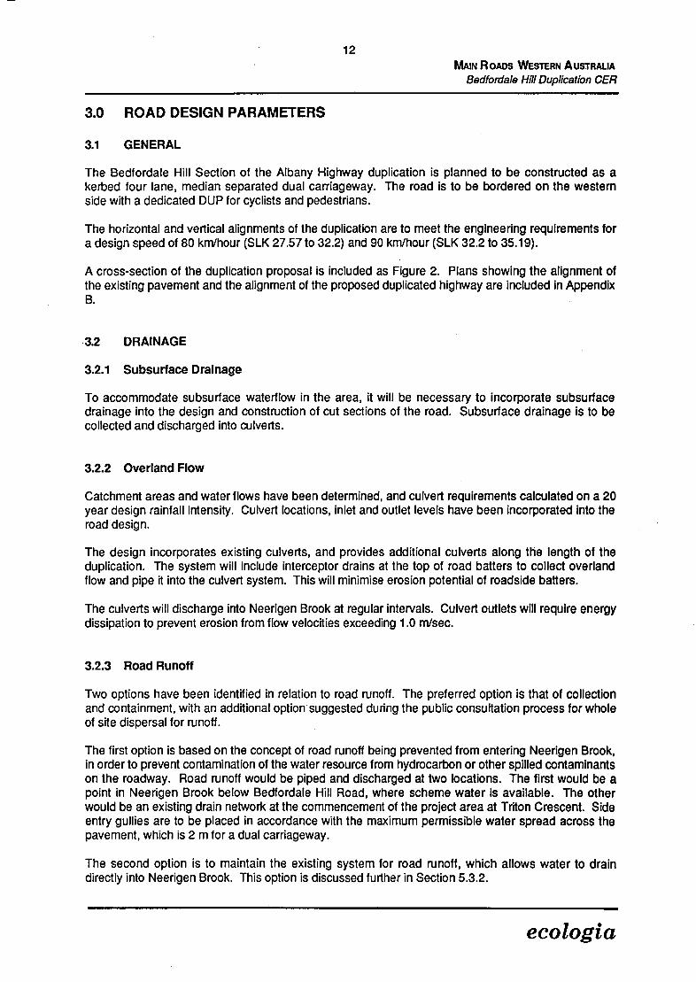
3.0 ROAD DESIGN PARAMETERS
3.1 GENERAL
The Bedfordale Hill Section of the Albany Highway duplication is planned to be constructed as a kerbed four lane, median separated dual carriageway. The road is to be bordered on the western side with a dedicated DUP for cyclists and pedestrians.
The horizontal and vertical alignments of the duplication are to meet the engineering requirements for a design speed of 80 km/hour (SLK 27.57 to 32.2) and 90 km/hour (SLK 32.2 to 35.19).
A cross-section of the duplication proposal is included as Figure 2. Plans showing the alignment of the existing pavement and the alignment of the proposed duplicated highway are included in Appendix B.
3.2 DRAINAGE
3.2.1 Subsurface Drainage
To accommodate subsurface waterflow in the area, it will be necessary to incorporate subsurface drainage into the design and construction of cut sections of the road. Subsurface drainage is to be collected and discharged into culverts.
3.2.2 Overland Flow
Catchment areas and water flows have been determined, and culvert requirements calculated on a 20 year design rainfall intensity. Culvert locations, inlet and outlet levels have been incorporated into the road design.
The design incorporates existing culverts, and provides additional culverts along the length of the duplication. The system will include interceptor drains at the top of road batters to collect overland flow and pipe it into the culvert system. This will minimise erosion potential of roadside batters.
The culverts will discharge into Neerigen Brook at regular intervals. Culvert outlets will require energy dissipation to prevent erosion from flow velocities exceeding 1.0 m/sec.
3.2.3 Road Runoff
Two options have been identified in relation to road runoff. The preferred option is that of collection and containment, with an additional option suggested during the public consultation process for whole of site dispersal for runoff.
The first option is based on the concept of road runoff being prevented from entering Neerigen Brook, in order to prevent contamination of the water resource from hydrocarbon or other spilled contaminants on the roadway. Road runoff would be piped and discharged at two locations. The first would be a point in Neerigen Brook below Bedfordale Hill Road, where scheme water is available. The other would be an existing drain network at the commencement of the project area at Triton Crescent. Side entry gullies are to be placed in accordance with the maximum permissible water spread across the pavement, which is 2 m for a dual carriageway.
The second option is to maintain the existing system for road runoff, which allows water to drain directly into Neerigen Brook. This option is discussed further in Section 5.3.2.
ecologia
13
MAIN ROADS WESTERN A USTRAUA
Bedfordale I-Jill Duplication CER
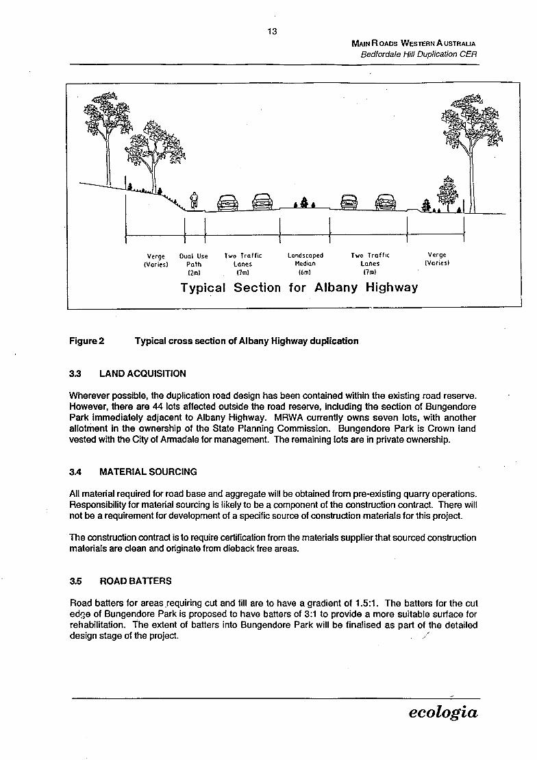
Verge Dual Use Two Traffic Landscaped Two Traffic Verge
(Varies) Path Lanes Median lanes (Varies)
(2m) (mi) (6m) (lm)
Typical Section for , Albany Highway
Figure 2 Typical cross section of Albany Highway duplication
3.3 LAND ACQUISITION
Wherever possible, the duplication road design has been contained within the existing road reserve. However, there are 44 lots affected outside the road reserve, including the section of Bungendore Park immediately adjacent to Albany Highway. MRWA currently owns seven lots, with another allotment in the ownership of the State Planning Commission. Bungendore Park is Crown land vested with the City of Armadale for management. The remaining lots are in private ownership.
3.4 MATERIAL SOURCING
All material required for road base and aggregate will be obtained from pre-existing quarry operations. Responsibility for material sourcing is likely to be a component of the construction contract. There will not be a requirement for development of a specific source of construction materials for this project.
The construction contract is to require certification from the materials supplier that sourced construction materials are clean and originate from dieback free areas.
3.5 ROAD BATFERS
Road batters for areas requiring cut and fill are to have a gradient of 1.5:1. The batters for the cut edge of Bungendore Park is proposed to have batters of 3:1 to provide a more suitable surface for rehabilitation. The extent of batters into Bungendore Park will be finalised as part of the detailed design stage of the project.
ecologia

14 MAIN Ros WESTERN AUSTRALIA
Bedfordale Hill Duplication CER
3.6 PUBLIC CONSULTATION
A comprehensive consultation programme was undertaken during the development of this proposal, which included consultation on the concept plan and the preliminary design, and establishment of a Community Liaison Group.
Environmental issues were raised by the public and interested agencies during the consultation programme. Where possible these issues have been addressed in preparation of the proposal documented within this CER. A summary of the results of the consultation programme is included in Appendix C.
No consultation has occurred directly concerned with this CER. The public review period for this document will form the public consultation exercise specifically concerned with environmental issues.
ecologia

15 MAIN R oos WESTERN A USTRALIA
Bedfordale Hill Dupilcation CER
4.0 EXISTING ENVIRONMENT
4.1 THE BEDFORDALE REGION
The City of Armadale consists of five wards and currently has a population of approximately 50000 people. The percentage of semi-rural inhabitants is unavailable but it must be noted that the average size of the rural holdings in the City of Armadale has decreased over the years from 42 ha (1945) to 28 ha (1974) (unpublished report, City of Armadale). This is attributed to the spread of urban development.
Tourism is a major industry in the South-west of Western Australia, and as such access to the towns of the South-west should be as easy and pleasant as possible. All changes to access roads should be as beneficial as possible to both the residents of the Armadale municipality and the tourism industry in the South-west of Western Australia.
Albany Highway climbs into the Darling Scarp via a re-entrant valley and reaches the crest around Bedfordale. The existing road is contained within a road reserve 25 to 40 metres wide. The reserve is bordered on the north and south by residential and agricultural holdings, as well as State conservation reserves. In addition, Neerigen Brook runs along the northern boundary of the reserve for almost the entire length of the proposed widening.
The project area consists of a semi-rural landscape situated approximately on the crest of the Darling Scarp. The immediate landscape surrounding the proposed road works is characterised by a semi-rural atmosphere because of the large rural blocks, orchards, a brook and period farm houses. The definition of the road reserve is achieved by large stands of both exotic and indigenous trees lining both the road verge and road reserve boundary.
The land use in this area is varied, with the main use being horticultural and agricultural concerns associated with the semi-rural atmosphere. The area contains a number of orchards and vineyards, semi-rural paddocks, hobby farms, commercial premises, pastures concerned with horse agistment and racing, and a Road Train Assembly Area. In addition the alignment also passes adjacent to Bungendore Park, and enters into State Forest to the east of the Road Train Assembly Area.
The visual quality throughout the project area is attractive and there are no areas which require special screening. There is enough variety in the landscape to provide interest for both the local inhabitants and the tourist. Intermittent views of the surrounding Swan Coastal Plain are obtained at high points of the Darling Scarp closer to Armadale.
4.2 CLIMATE
The climate for the region in which Bedfordale is situated is classified as "dry Mediterranean", with a wet winter and a generally dry summer. The dry Mediterranean climate is charactarised by 5-6 dry months (Beard, 1979). The rainfall comes from predominantly westerly winds off low pressure cyclonic fronts. Bedfordale receives a mean annual rainfall of 1200 mm due to its proximity to the crest of the Darling Scarp.
The temperatures are generally mild, with an average maximum of 21.6 °C and an average minimum of 9.5 °C. January is the hottest month and July is the coldest. The proximity to the ocean moderates the temperature extremes providing the Bedfordale area with a pleasant mild climate.
ecologia

16 MAIN R OS WESTERN A USTRALIA
Bedlordale Hill Duplication CER
4.3 GEOLOGY, SOILS AND LANDFORM
The study area occurs on the Darling Scarp, which forms the interface between the Swan Coastal Plain and the Darling Plateau. The Darling Scarp extends from Muchea in the north, to Dardanup in the South (Department of Planning & Urban Development, 1993a). Around Bedfordale the Scarp rises to a height of 300 m.
The Darling Plateau overlays the Archaean rocks of the Yilgarn Block. Typically, the geology consists of granites, gneisses and migmatites with some intrusive dolerite dykes. The bedrock is usually overlain by a lateritic layer and associated gravels (Department of Planning & Urban Development, 1 993a).
Within the study area, the northern end of the alignment overlays granitic materials, consisting of course-grained granites and finer grained dolerites. The central section of the study area passes through alluvial clays overlying lateritic soils. The southern end of the alignment is located over lateritic soils, comprised of sands, gravels and minor clays (Soil & Rock Engineering, 1996a).
The soils in the Darling Scarp are of two distinct patterns: the western part is characterised by laterite gravels and block laterite, while the eastern part is mainly ironstone gravels (Beard, 1979). The presence of clay results in high water holding capacity so the soils are waterlogged in winter but extremely hard when they dry out in summer.
Soil sampling for geotechnical investigations have shown that the soil types vary from silty clays through to gravelly sands according to the base geology. The typical soil types are:
Sandy Gravel / Gravelly Sand: medium dense to dense, orange/brown, medium grained sand, medium to course grained gravels, minor cobble to boulder (up to 1.5 m) size laterites throughout, becoming more predominant at depth, clay traces at depth, and extending to depths of 1.9 - 3.8 m.
Silty Clay / Sandy Clay: very stiff to stiff, predominantly pale grey, mottled yellow, pink, medium grained sands, minor medium quartz grains at depth, becoming stiff to firm and moist to very moist with depth and grading to predominantly white, and extending to the depths investigated between 6.0 -7.Om.
Full testpit and borehole logs, including soil characteristic descriptions are contained in Soil & Rock Engineering (1996b).
The history of soil use in the Scarp is mainly agricultural and horticultural with low scale cultivation of fruit trees. It is expected that levels of fertilisers, herbicides and pesticides would be relatively high in areas of the Scarp, where the clay accumulates solutes such as salts, chemical toxins and effluent.
In the road reserve, the soils may have been modified over time with the use of soil additives, land fill and fertilisers. This may have an adverse effect on the re-establishment of native species in these areas. However, there are still significant stands of remnant vegetation where the soil is expected to be relatively undisturbed.
The northern edge of the road reserve in the study area is delimited by Neerigen Brook which runs adjacent to the reserve along the entire length of the proposed works area. Albany Highway runs along the southern edge of the brook, and the reserve then continues to climb in elevation to the south.
ecologia

17 MAIN R os WESTERN A USTRALIA
Bedfordale Hill Dupilcafion CER
4.4 HYDROLOGY
For the entire length of the proposed works, Neerigen Brook traverses the reserve on the northern side of Albany Highway. This brook originates in the vicinity of Springfield and Dmietrieff Roads and has some minor tributaries near Armadale before ending in Wungong Brook near Lake Road 3 km west of Armadale. The brook is used as a source of potable water by some residents and as such is of special concern.
Neerigen Brook has a catchment of 10 km2 between the Road Train Assembly Area and Bedfordale Hill Road. The catchment extends between 750 m - 1.5 km on either side of Neerigen Brook and Albany Highway. The boundary of the Neerigen Brook catchment is shown in Figure 3.
With the exception of some minor gullies which carry concentrated stormwater from the local road system, the remainder of the project site is well drained with water shedding evenly off the slopes.
4.5 VEGETATION AND FLORA
4.5.1 RegIonal DescrIption
The Bedfordale area lies within the Darling Botanical District System in the Dale Subdistrict. The Darling System encompasses the northern Jarrah forest which is associated with the laterite-capped plateau. The predominant catena in the Darling System is comprised of the following plant communities, as described by Speck (1958) and Beard (1979):
The open vegetation of granite rock outcrops which protrude through the laterite mantle.
Jarrah forest on the laterite plateau and screes descending from its edges.
Marri - Wandoo woodland on the younger red soils of the scarp and the slopes of the deeply excavated Avon, Helena and Chittering Valleys.
River gums and paperbarks along the watercourses.
Minor catenas occur within the undulations of the major catena. Havel's (1975) studies delineated the specific "site-vegetation types" occurring within the minor catenas, finding that the presence and distribution of plant communities closely reflect local soil types, topography and moisture conditions. Due to the general nature of this study, only the plant communities linked to the major catena are employed, with the exception of two very basic divisions in the Jarrah forest community.
4.5.2 Site DescriptIon
Prior to widespread clearing and colonisation, the study area was mainly Jarrah forest with river gums and paperbarks occurring in wetter areas. Using the Beard-Webb Formula the intact native vegetation of the Bedfordale study area is classified as Eucalyptus (jarrah and marri) medium trees (10 - 30 m tall) with a mid to dense canopy (Beard & Webb, 1974).
In the proposed road works area, ecologia Environmental Consultants have identified one major native vegetation type with variations in understorey. Vegetation types throughout the study area are described by means of specific reference points. Mapped associations are shown in Figures 4 - 7.
ecologia

G
Nep..
I %TOWN .
C - -
'C
•
gd
1 \waterwe\
I \\ ARMADALE
I • 11 I ' I \4
4'
t -'---•-- •
I • •----•-••- AA4561
r I BUNGENDORE
o
(
450 84ha '--i c
-
/
/ I j System 6 Area M80
- c - Neerigen Brook Catchment Area N
Source: Dept of Conservotion 0 500 1000m and Environment I983267
Scale 1:30000
Neerigen Brook Catchment Area and Portion of System 6 Area M80
Figure 3

19
MAIN ROADS WESTERN AUSTRALIA Bedfordale Hill Duplication CER
Reference Point 1: This area is characterised by a dense tall shrubland dominated by Dryandra sessilis and Agonis linearifolia. Patches of Aiocasuarina fraseriana/ Eucalyptus calophylla over Acacia puichella are also present. Some non-native grasses are present, particularly adjacent to the roadside (Figure 7).
Reference Point 2: This area is dominated by a row of tall introduced Eucalyptus trees over introduced grasses (Figure 7).
Reference Point 3: This area is characterised by an overstorey of Eucalyptus calophylla (Marri) with an open shrubland which includes Dryandra sessilis, Dryandra nivea, Xanthorrhoea preissli, Agonis linearifolla, Acacia puichella, Hakea undulata and Hibbertia hypericoides. The ground layer is dominated by sedges with Lepidosperma species common (Figure 7).
Reference Point 4: This area contains an open overstorey of Eucalyptus calophylla (Marri) over a relatively low, dense shrubland (0.5 - 1.5 m in height) which includes, Hakea undulata, Hakea amplexicaulis, Hibbertia hypericoides, Petrophile striata, Xanthorrhoea preissii and Acacia puichella, over predominantly sedges including Lepidosperma species, Mesomelaena tetragona, and Restionaceae species. This vegetation is in good condition and relatively diverse (Figure 5).
Reference Point 5: This area is characterised by a dense shrubland of Agonis linearifolia over dense sedges and *paspalum dilatum. (This tall weed grass is particularly dominant on the edge of this verge). The area was still swampy at the time of survey with a small channel of water ranging from 0.5 to 1 m in width. This shrubland extends 4-6 m. Behind it an open Eucalyptus calophylla woodland, similar to Reference Point 3, occurs over Dryandra sessilis, Hakea trifurcata, Xanthorrhoea preissli and Agonis ilnearifolla (Figure 6).
Reference Point 6: The vegetation of Neerigen Brook at this point consists of dense woodland dominated by Marri Eucalyptus calophylla, together with an open cover of Flooded Gum Eucalyptus rudis. The latter species becomes progressively less common as the ground becomes drier. Paperbark Melaleuca species are present in places, and may form a moderately dense tall shrub layer. The ground is dominated by a dense cover of grasses and sedges which are favoured by the damp to wet conditions (Figure 4).
Reference Point 7: This vegetation type features an open woodland dominated by Eucalyptus calophylla. The shrub understorey has been largely cleared and is now sparse. A dense cover of soft grasses, including introduced species such as *Briza maxima, replaces the low shrubs as the dominant ground cover vegetation (Figure 4).
Reference Point 8: This area has an open cover of Marri Eucalyptus calophylla over a moderately dense low shrub understorey (i.e. less than 1 m in height). The low shrub layer includes a variety of species such as Acacia pulchella, Dryandra nivea, Hakea undulata, Petrophile striata and Xanthorrhoea preissii. At ground level there is an open cover of sedges including species of Lepidosperma (Figure 5).
The remaining vegetation units have been modified by human activities and are divided into disturbed mixed jarrah and marri woodland, disturbed marri woodland, orchards, exotic conifer plantations and cleared land. A vegetation list for the study area is included in Appendix D.
ecologia

gi
V4
V
fl
- V &4!: a-. .s. •'. :
• -. - S...
- ;... . r i
I. • 151 NO , pr __
-I..
. - .4
::. : : - - - . • . W4 r,k
S4. - 444 ..
.• __
• .
I -• . . :

\\ \\ x
0 • X x
otdole Hiji Road :
x
:
° x0 o00.:
x 0 J
. 0
0 0 0 0 0
0 x x
KID
0
00
x
x XeeX
x
o 0
:Ox x . . . : : : . : : /x
. . . . . B.05• . x x . o .' :
••• Tree Ferns . . . . . . x : . . . r .29-36
SLK
/Exotic woodland
:: :::::::: calophla woodland D•9 .
Sparse marri woodland
0 0 01 Orchards Mixed marri Eucalyptus calophylla/ Flooded Gum Eucalyptus rudis
Exotic conifer plantations Urban development
:1 Cleared land RP4 Vegetation reference point
B.04 Heritage site
ANP Norfolk Island Pine
Vegetation of Albany Highway
o 50 100 400m Figure 5
I I 1
Scale 1:5,000
ecologia

0 -: 0 .0
0
. . . 0 0 0 0
0
LBAN <
0 +7;sLx 0 \ SHEET INDEX A
0
0
x
0 :::::::..•:... x
' b X\. 0 LC ............X Neerjge ....X
0 ,•__ .......x X
x •••s• Tree Ferns . Hi 'Jr1W4y X 0 Cl0 • 0
Mixed Eucalyptus/Exotic woodland B 03• £'r, 0 0
0 0 0 0 0
X Marri Eucalyptus calophylla woodland ____ - ... . . . . . • . : . 0
Sparse marri woodland 0
[0 0 Orchards :
Exotic conifer plantations
J: :] Cleared land 0B.03 Heritage site
ANP Norfolk Island Pine RP5 Vegetation reference point
U LC Lebanese Cedar
Vegetation of Albany Highway 0 50 100 400m I I I
Figure 6 Scale 1:5,000
ecologia

14/A /X
ff ( 7. . : ( x X . I
\-Gc14 X x lJjJjJjjjUiIIID'
xJ I7 x,X x t X , ( . . W I / \ X V. . . . . .1' x . . x
eerI X 00
26
Tree Ferns
-55-73
A . . . . . VAIG
..L. ..:••
A F I
SHEET INDEX
Mixed Eucalyptus Iexotic woodland
1 X Marri Eucalyptus calophylla woodland
Sparse marri woodland
I11111 I Disturbed sparse mixed jarrah and marri woodland
Mixed jarrah, Eucalyptus marginata and marri E. calophylla forest
Exotic conifer plantations
1 0 Orchards
.1 Cleared land
13.0 1 Heritage site
RP3 Vegetation reference point
0 50 200m I I
Scale 1:5,000
Vegetation of Albany Highway
Figure 7
ecologia

24 MAIN RoADS WESTERN AUSTRALIA
Bedfordale Hill Duplication CER
4.6 DIEBACK
"Dieback" refers to the impact of soil borne fungal plant pathogens such as Phytophthora cinnamomi, which result in root rot disease. However the visual effects of dieback or stress may be the result of several factors such as fire, insect attack (especially on Eucalyptus marginata) and age (for older trees), as well as fungal plant pathogens. Irrespective of the causal factor, the expression of physiological stress in a plant community is usually perceived as defoliation or discolouration, in particular, chlorosis of foliage. The degree of physiological stress evident in the plant communities was assessed by ranking as follows:
Rank Physiological Stress o - No evidence of stress. 1 - Odd plant showing signs of stress, none dead. 2 - One or two stressed plants, usually under severe stress, near death. 3 - Scattered stressed and dead plants. 4 - Susceptible plants dying or dead. 5 - "Graveyard" death, most trees dead.
Subjective attempts were made to define the possible stressors, but no verification by analytical techniques was undertaken.
Examination of the vegetation remnants of the Bedfordale Hill project area revealed that the vegetation communities present were subject to a low physiological stress level of ranking 0 or 1. Some Eucalyptus calophylla appear to be affected by Armillaria infection. Clearing, intensive grazing and fires over a protracted period have eliminated the majority of good understorey "dieback" indicator species from disturbed areas. However, dieback infections would be quite old and spread extensively, particularly in the cleared areas along the drainage line. Although no active dieback fronts were noted in the vegetation remnants, the disease is almost certain to be present, if only at very low levels, due to the extreme degree of historical disturbance and proximity of transport vectors.
4.7 FAUNA
Limited information is available on fauna of the Darling Scarp, due to the lack of comprehensive biological surveys undertaken. Within the Darling Scarp fauna habitats are closely aligned with landform - vegetation associations. On the basis of known habitat preferences, the project area may potentially support approximately 100 bird species, 17 native (including nine bat species) and five introduced mammals, 41 reptiles and 11 amphibian species.
There are no known species in the Darling Ranges that are restricted to that area, however marked changes in abundance and distribution of fauna populations, including local extinctions of mammal species, and severe reductions in population size of bird and reptile species has occurred (Department of Planning & Urban Development, 1993a).
In the areas of the proposed duplication, there are no species with a declared conservation status. However Southern Brown Bandicoots Isoodon obesulus are known to exist in Bungendore Park.
The Bungendore Park Management Committee has indicated that there is a population of King Skinks Egernia kingiiwhich are located within the impact area for this proposal. King Skinks are olive brown to black in colour, and can grow to 50 cm in length. They are distributed throughout the south-west of Western Australia and its offshore islands. When occurring away from coastal areas, King Skinks occupy rock outcrops (Cogger, 1992). This species is not listed as protected fauna by the Department of Conservation and Land Management (CALM), and as such has no special protection status.
ecologia
25 MAIN R os WESTERN A USTRALIA
Bedfordale Hill Dupilcation CER
4.8 BUNGENDORE PARK
Bungendore Park is situated to the south of Albany Highway (see Figure 3). An 'A' Class Reserve (1'A4561 ), the park was vested in 1897 with the Armadale Kelmscott Road Board which was renamed the Armadale City Council in 1965. With an area of 498 hectares, the park has four listed bush walks and two information display shelters.
In addition to being an "A" Class Reserve, Bungendore Park forms a component of the System 6 Area M80 - Darling Scarp - as recommended by the EPA in their assessment of conservation reserves in Western Australia (Department of Conservation and Environment, 1983). This assessment classifies the southern and western slopes of Bungendore Park as the most floristically important within the park boundaries.
The recommendations made for the M80 area in the assessment were:
M80.1 That the general recommendations on planning and management of Regional Parks be applied to this area.
M80.2 That the Metropolitan Region Planning Authority consider "reserving" those portions not already reserves for Parks and Recreation under the Metropolitan Region Scheme.
M80.3 That the vacant Crown land adjacent to Reserve tA4561 be declared an 'A' Class Reserve for Parklands and that the Reserve be vested in the Town of Armadale.
M80.4 That the operators of quarries be required to produce assessments of the environmental implications of existing and future quarries and plans for their rehabilitation and restoration.
M80.5 That roads be excluded entirely from the valley south of Crystal Brook, and the Ellis Brook valley, and that no further roads be constructed in the Bickley Valley and Mills Road Valley.
(Department of Conservation and Environment, 1983:261).
As a component of the System Six area M80, Bungendore Park is also within the boundaries of the Darling Range Regional Park; one of the areas of regional open space which has been identified by planning procedures as having outstanding recreation and conservation values (Department of Planning and Urban Development, 1993b).
Bungendore Park also contains the Southern Brown Bandicoot Isoodon obesulus. The Bandicoot is considered to be of State conservation significance, by virtue of the current Schedule 1 Wildlife Conservation Act 1950 status. Any removal of habitat that is of significance to the Bandicoot would be detrimental to the population in the area.
Another issue is that of Flora Management, mainly in reference to protection of native and exotic species. Bungendore park has two orchid species within it's boundaries that are listed on the Declared Rare and Priority Flora List (Atkins, 1995). These are:
Dwarf Bee Orchid (Diuris micrantha): The Dwarf Bee Orchid is confined to a small swampy area south of Perth, where it grows in shallow water amongst dense native sedges (Hoffman & Brown, 1992).
Star Orchid (Thelymitra stellata): The Star Orchid occurs in isolated colonies between Three Springs and Pinjarra. Near Perth, it is found amongst shrubs in the 'lateritic barns of the Jarrah forest (Hoffman & Brown, 1992).
ecologia

MAIN R OADS WESTERN A USTRALIA Bedfordale Hill Duplication CER
Both of these orchids are now Declared Rare Flora, having been upgraded from Priority 2 status. Declared Rare Flora are taxa which have been adequately searched for and are deemed to be in the wild either rare, in danger of extinction, or otherwise in need of special protection and have been gazetted as such (CALM, 1995).
4.9 HERITAGE TOPICS
4.9.1 Aboriginal Sites
The Aboriginal Affairs Department has three sites of significance recorded in the vicinity of the Albany Highway Bedfordale Hill project area. Two of these sites are related to Neerigen Brook; one is a mythological site associated with the Waugal and the other is recorded as a water source and camp site overlooking the Neerigen Brook. The third site is an artef act scatter located near the northern end of the study area.
4.9.2 Cultural Heritage
Currently there are no listings in the Bedfordale area with either The National Trust of Australia or the Heritage Council of Western Australia. However there is a local Municipal Heritage Inventory, managed by the City of Armadale, that has four listings for the project area: Adderley's Residence, Mount Paradise, Paradise Cottage and Willow Heights.
4.9.3 Visual Amenity
The Darling Scarp and Ranges comprises a major landscape unit which forms a distinctive visual feature. The significance of the landform is twofold; a backdrop to Metropolitan Perth, and as a viewing point for the coastal plain and Indian Ocean.
As a component of the Darling Range Regional Park planning study, a visual resource assessment of the Darling Range sub-region was undertaken (DPUD, 1993c). The assessment entailed the application of the Visual Resource Management System, which requires definition of:
Landscape Character Types;
Scenic Quality Assessment;
Seen Area Assessment and Public Sensitivity Level; and
Landscape Management Zones and Visual Quality Objectives.
The study area falls into the Darling Plateau Landscape Character Type, Sub Type: Darling Upland. This unit includes the scarp face, areas of undulating uplands with gently sloping hills and valleys, deep V-shaped valleys and fast flowing rivers.
The alignment of Albany Highway falls within a category of high scenic quality from the commencement of the study area (Triton Crescent) to the point at where the Highway diverges from the Bungendore Park boundary. The remainder of the alignment subject to the duplication proposal is classified as having moderate scenic quality.
Albany Highway as it passes through Bedfordale has a viewshed of up to about 500 m, which provides a seen area of foreground only. The Darling Range visual resource assessment indicated major travel routes with the highest public sensitivity levels. Albany Highway within the City of Armadale was not included within this category. However, the alignment was allocated as a High Priority Landscape Management Zone.
ecologia

27
MAIN ROADS WESTERN A USTRALIA
Bedfordale Hill Dupication CER
The visual quality objective for the High Priority Landscape Management Zone is one of maximum retention of existing Landscape Character. Under this classification, any visual alterations should be designed to have a minimum visual impact as far as practical to an observer after a period of five years from the initial alteration.
ecologia
28 MAIN Roos WESTERN AUSTRALIA
Bedfordale Hill Duplication CER
5.0 ANTICIPATED ENVIRONMENTAL IMPACTS
5.1 GENERAL
As the route traverses a near metropolitan semi-rural landscape within the Darling Scarp the potential exists for the proposed roadworks to produce negative impacts on both the biophysical and social environment.
During the early feasibility stages of the project, and according to the CER guidelines issued by the DEP, the key topics identified are:
(1) Biophysical System 6 Area M80: impact to Bungendore Park, an 'A' Class Reserve and System 6 area; Rare flora and fauna: protection of any rare flora and fauna in accordance with the Wildlife Conservation Act 1950; Remnant vegetation: identification and protection of any regionally significant vegetation; Erosion: prevention of erosion due to vegetation clearing and increased run-off; Dieback: identification of the dieback status of the area, and development of dieback management measures to ensure containment or maintenance as a dieback free area; Vegetation clearing: minimisation of clearing of remnant native vegetation occurring within the road reserve; and Water Supply: management of demand for water during construction from Neerigen Brook so that environmental needs are met.
(2) Pollution Dust control: dwellings and conservation areas being kept free from unacceptable impacts of dust Contaminants from stormwater: collection and disposal systems designed to ensure that reduced or no contaminants reach Neerigen Brook; Noise: noise at residential dwellings should comply with statutory requirements both during construction and during operation; Water quality in Neerigen Brook: during construction turbidity of Neerigen Brook requires management; Hydrology of Neerigen Brook: hydrological regime of Neerigen Brook should be maintained at pre-construction levels; and Environmental values of Neerigen Brook: environmental values to be maintained or enhanced.
In addition to the key topics, a number of additional aspects of impact to heritage features and the social environment are discussed, although they may fall outside the scope of the definition of environment under the Environmental Protection Act 1986. These topics relate to heritage values, visual amenity and social impacts arising from construction activities and are provided as extra information on project management for members of the public as opposed to environmental topics requiring assessment by the EPA.
5.2 POTENTIAL IMPACTS ON THE BIOPHYSICAL ENVIRONMENT
5.2.1 Bungendore Park
The road design will result in roadworks affecting the Albany Highway edge of the Park. The extent of the ingress into the park will depend upon batter slopes required for road construction. Current plans using a batter slope of 1.5:1 indicate a requirement for a maximum of 25 m ingress along the northern edge of Bungendore Park. However, a batter slope of 3:1 is proposed, and is to be investigated as a component of the Detailed Design stage of the project.
ecologia

29
MAIN RoADS WESTERN AUSTRALIA Bodfordale Hill Dupilcation CER
Bungendore Park is adjacent to Albany Highway between SLK 30.30 to 30.64, therefore having a total length of 340 m of the park edge to be effected by roadworks. Actual acquisition of land for road pavement is up to 7 m along the park edge, giving a total area of no more than 2380 m2 required for acquisition.
In addition to the area for road pavement construction, a requirement exists in this location for cut batters. The total area of impact on Bungendore Park is based upon the scenario of a batter slope of 3:1 being implemented, and includes the 2380 m2 for roadworks. The total extent of batters ranges between 10 - 70 m along the park boundary. The total area of impact will therefore be approximately 1.4 ha. This represents 0.28 % of the total area of Bungendore Park.
The vegetation along the Albany Highway edge of Bungendore Park is Marri Eucalyptus calophylla woodland, which is well represented throughout the study area.
The impact of the project on Bungendore Park will include clearing of vegetation and alteration of Iandform due to the necessity to cut at this location to obtain necessary grades and batter slopes. The area of cut through the Bungendore Park boundary will occur through sandy gravel, described as fine to medium grained sand, and medium to course grained gravel with clay traces throughout (Soil & Rock Engineering, This area of cut is underlain by gravels and cemented laterites at between 0.3 - 1.5 m, and laterite is believed to be extensive within the cut sections. Although the 1.5:1 batter would impinge less on the park area, the steeper lateritic profile would prove difficult to revegetate and would therefore have a higher level of visual intrusion than the more gentle slope.
A population of King Skinks (Egernia king!,) is known to be located within the area which will require reworking for road construction. A community of 15 -20 King Skinks are to be relocated to an area of suitable habitat between 200 - 300 m further into the Park. The relocation will be overseen by the Bungendore Park Management Committee and the WA Museum, and will involve a volunteer component. The required fauna licence to undertake the activity has been approved by CALM. MRWA are funding a grant for the relocation programme.
The proposed duplication does not compromise the System 6 recommendations made for the M80 Darling Range location.
5.2.2 Rare Flora And Fauna
Declared Rare Flora (DRF) and Priority Flora Species are those flora species protected under the Wildlife Conservation Act, 1950. Priority species are maintained on a "Reserve List" and assigned to one of four categories. Bungendore Park contains two species of orchids that are listed as Declared Rare Flora (DRF).
These orchids are the Dwarf Bee Orchid (Diur!s micrantha) which is located within swampy areas populated with native sedges. This habitat is not located within the area of Bungendore Park required for roadworks. The Star Orchid (Thelymitra stellata) is generally found on lateritic barns and so is unlikely to be found on the sandy gravel soils on the northern boundary of the Park. A DRF survey will be undertaken in spring to ensure than no DRF or Priority Flora are located within the impact area.
The roadside vegetation and the impact area of Bungendore Park are not suitable habitats for the Southern Brown Bandicoot, which is the only known Schedule fauna species from the study area. The fauna as a whole cannot be considered as unique or restricted in distribution. Most species are common and widespread throughout the region.
ecologia
30 MAIN RoADS WESTERN AUSTRALIA
Bedfordale Hill Dupilcation CER
5.2.3 RegIonally Significant Vegetation
The study area falls within the Jarrah - Marri forest on laterite plateau, which is typical for the Darling System (Beard, 1979). The intact native vegetation from larger vegetation stands adjacent to the Albany Highway alignment is in good condition with the exception of the 5 m strip directly adjacent to the road pavement. Weed infestation is much greater next to the road due to less native plant cover which facilitates weed establishment.
The project area is surrounded by residential properties with large tracts of cleared land used for horticultural and agricultural practices. The occurrence of weed species in this land is much more prevalent than in the remaining stands of native trees.
The existing road reserve vegetation is at best a representative remnant of the original cover, however it has been severely degraded over most of its area due to invasion of weed species and human interference such as clearing.
The strip of vegetation which is proposed to be cleared on either side of Albany Highway is well represented in the adjoining vegetation and throughout the conservation estate. In the locality, the Jarrah - Marri woodland is conserved in Bungendore Park, and is effectively protected within water supply reserves over the catchments for the Wungong Dam and the Churchman Brook Reservoir.
5.2.4 Vegetation Clearing
Between Triton Crescent (SLK 27.46) and Bedfordale Hill Road (SLK 28.66), road construction will occur within the existing road reserve, except for two small areas required for batters. The road reserve contains a remnant Marri overstorey. On average, a total of 10 m either side of the existing pavement could be impacted by the duplication. A total area of 1.2 ha of sparse Marri woodland would be impacted in this section.
Between Bedfordale Hill Road (SLK 28.66) and the Bungendore Park boundary (SLK 30.64) the area of impact is predominantly cleared land. Clearing of native vegetation is limited within this sector.
As discussed in Section 6.2.1, a maximum of 1.4 ha of Marri woodland on the Bungendore Park boundary would require clearing.
Albany Highway in the sector between Nelson Street (SLK 30.80) and Springfield Road (SLK 33.64) is bounded by cleared land and orchards, with occasional stretches of Marri overstorey within the existing road reserve. The impact on a 140 m strip of Marri trees (between SLK 31.88 and SLK 32.02) will be minimised by the use of a retaining wall instead of full batters. An additional area of approximately 0.3 ha between SLK 32.82 and SLK 33.02 consisting of sparse Marri woodland will require clearing on the southern side of the existing Albany Highway alignment.
The remaining sector is that between Springfield Road (SLK 33.66) and the Road Train Assembly Area (SLK 35.18). Between SLK 33.66 and SLK 34.06 a 15 m strip of Marri woodland will be impacted by the proposal (a maximum of 0.6 ha).
The last area of native vegetation that will require clearing occurs between SLK 34.58 and SLK 35.08. This area is a mixed Jarrah and Marri woodland occurring within the existing road reserve. A total area of approximately 1 hectare will be impacted by this proposal.
A total of approximately 4.55 hectares of native remnant vegetation will require clearing as a result of this project. As discussed in Section 6.2.3 the vegetation is typical of that found in the Darling Scarp region.
ecologia

31 MAIN RoADS WESTERN AUSTRALIA
Bedfordale Hill Duplication CER
5.2.5 Dleback
The dieback status of the project area is unconfirmed, however due to the level of disturbance, and the susceptibility of the vegetation, dieback infection is likely to be present. The site has been treated as "not effectively quarantined" for management purposes to minimise the risk of dieback being introduced from external areas.
The dieback status of the area will be determined prior to construction, and a management plan developed according to the results. The management strategy will be based upon ensuring that no soil movement will occur between infected and non-infected sites within the project area.
5.2.6 Neerigen Brook
Due to the close proximity of Neerigen Brook to the existing road alignment, the duplication project will impinge upon the drainage line in some locations. Further, in the vicinity of Bedfordale Hill Road, the extent of the roadworks impinges upon the Brook alignment. Consequently, it will be necessary to deviate the Brook from its current alignment to allow the duplication to proceed within the engineering design criteria. The impacts of this requirement are manageable, based upon engineering design and construction strategies to ensure that the long-term water quality and the aesthetic landscape are not detrimentally impacted.
The duplication project will require the deviation of Neerigen Brook in two locations:
south of Bedfordale Hill Road to where the Brook crosses beneath Albany Highway; and
a portion of the Brook to the north of Admiral Road.
The deviation of Neerigen Brook in the Bedfordale Hill locality will require the creation of a new channel up to 10 m west of its existing alignment. A total length of up to 250 m will be affected. The deviation north of Admiral Road will affect approximately 80 m of the Brook, resulting in a movement of up to 5 m east of its existing alignment.
Direct impacts of the required deviation will occur in reference to water quality during the construction phase of the brook realignment. This will predominantly be in terms of a temporary increase in the sediment load carried by the brook. The hydraulic characteristics of the brook, in terms of flow rates and velocities will need to be accounted for in the design of the channel bed for the realignment.
5.2.7 Erosion Potential
Batter slopes for areas of cut and fill have been determined through geotechnical investigations to ascertain construction materials and stability factors for the design process. Gradients of batters are recommended to be between 1.5:1 and 1.75:1.
The potential for scouring and slip failures on cut slopes from surface drainage is possible, and has previously occurred in the study area. Potential for erosion and slip failure is reduced through the geotechnical investigations determining the suitability of the site materials for batters. In combination with the drainage system and rehabilitation measures erosion potential for the project will be minimised.
ecologia

32 MAIN ROADS WESTERN A USTRALIA
Bedlordale Hill Duplication CER
5.3 POTENTIAL POLLUTION IMPACT FROM THE PROPOSAL
5.3.1 Dust
The impact of dust generation in residential areas is primarily a social impact, causing nuisance in the form of dust settling on cars, laundry and outdoor furniture. In high volumes, dust may also have implications for human health; particularly in reference to respiratory complaints and eye irritations. Dust may also impact vegetation adjacent to works areas, where it settles on leaves and hinders biological function.
Dust will be generated during the construction phase of the project due to ground disturbance from earthworking. The potential for dust generation from the site will continue until the rehabilitation is successfully implemented.
5.3.2 DraInage
Under the existing situation for drainage, the overland flow and road drainage flow enter Neerigen Brook along its whole length. There are no provisions to prevent fluid or solid spills from entering the Brook.
Two options for the management of drainage are contained within this CER. The first is the preferred option which involves the separation of overland flow from road drainage flow. The second option arose during the public consultation programme and is based upon maintaining the current drainage characteristics of the project area.
Separation of Overland Flow and Road Runoff In order to minimise the possibility of pollutants reaching the brook from the road surface, the preferred drainage system is separated into two components; overland flow and road drainage flow. The rationale is to maintain the current flow of water from the catchment to Neerigen Brook, but to minimise the risk of having road runoff contaminated by either transport spillage or the conglomeration of oils and other substances which amass on the road surface during the dry summer months enter the water flow.
Overland flow from the Neerigen Brook catchment yields good quality water which is used by local residents for domestic use. Separation of road drainage allows the opportunity for containing any possible spill within the main piping system and therefore prevent it from entering Neerigen Brook itself. The control mechanism will be a locking gate at the exit pipe at the last manhole. This system will provide greater protection than any small basins or ponds.
The catchment of the road surface from the Road Train Assembly Area to the intersection at Bedfordale Hill Road is 0.12 km2, in comparison to the overland flow catchment area of 6km2, with water volumes entering Neerigen Brook of 0.7 m3/sec from a total catchment runoff volume of 6.4 m3/sec. The removal of this volume of water directly from the total volume of the Brook during rainfall events will not significantly alter the hydrological characteristics of Neerigen Brook.
The discharge point of piped road runoff joins with Neerigen Brook at the location where the brook becomes a designated drainage reserve. The flow rate and volume of water at this point will prevent the settling and sedimentation of minor pollutants at the discharge point. Sufficient dilution is expected to occur to prevent contaminant levels below the discharge point being higher than those that currently occur.
This option is consistent with the DEP Guidelines for the CER requiring that stormwater collection and disposal systems should be designed to ensure that minimal or no contaminants reach Neerigen Brook.
ecologia

33 MAIN A os WESTERN A USTRAUA
Bedfordaio Hill Duplication CER
The separation of overland flow from road surface runoff is the option preferred by MRWA for this project.
No Alteration to Drainage System By not providing separation of overland flow from road runoff, pollutants from the road surface can enter the Brook and will therefore occur in water drawn from the Brook by local residents.
There would be no possibility of containing any spills that occurred on the roadway; a situation which would cause serious disruption to residents unable to draw from the Brook in this eventuality. This option is inconsistent with the DEP Guideline stating the stormwater collection and disposal systems should be designed to ensure that reduced or not contaminants reach Neerigen Brook.
5.3.3 Noise
MRWA have established noise assessment methodology and noise level criteria for new roads and road upgrading. The MRWA practice on noise assessment and mitigation is utilised in the absence of other policies in this regard.
The Bedfordale Hill project is categorised as an upgrading project. The objectives of a traffic noise impact assessment for the project are to:
establish existing levels of noise along the project;
determine the future noise impact of traffic using the road; and
identify noise control options to achieve Noise Level Objectives.
Noise level objectives are specified upper limits of traffic noise which should not be exceeded, and apply outside residential buildings. In general, the objective for existing roadways is to limit any noise level increase to 3 dB(A). That is, any increase due to road modification is considered acceptable if the increase is limited to 3 dB(A). The Acoustic Assessment for the Bedfordale Hill project was performed by Herring Storer Acoustics (1996).
The finding of the noise assessment is that three residential locations may be adversely impacted by noise level increase. The expansion will not change the acoustic environment for any other residences. The cause of the noise level increase is road realignment that results in the traffic being closer to some residential locations.
5.4 HERITAGE AND SOCIAL TOPICS
5.4.1 AborigInal Heritage
None of the three sites currently registered with the Aboriginal Affairs Department lies within the impact area of the proposed road duplication. Additional ethnographic and archaeological survey work will be undertaken prior to construction to ensure that no unregistered sites will be impacted by this proposal.
5.4.2 European Heritage
Of all the sites mentioned, Paradise Cottage is of the greatest importance as it lies within the reserve, very close to the existing route of Albany Highway (Figure 5). All due care must be taken to ensure that no damage is sustained by this site.
ecologia

34 MAIN Rows WESTERN AUSTRALIA
Bodfordala Hill Duplication CER
Willow Heights has been identified as being within the area required for acquisition for the duplication project. The remaining sites are outside the direct impact area of the roadworks.
Willow Heights has been purchased by MRWA and consultants have been appointed to consider options available for relocating the building to another site. This process is being undertaken in association with the City of Armadale.
There are significant stands of exotic plants that may be of Cultural Heritage value, although no specific listings were found with the Heritage Council of Western Australia or the City of Armadale Draft Municipal Heritage Inventory for this area. Although there are no specifically protected trees, the vegetation contributes to the visual amenity of the current road alignment. The proposed alignment will require the removal of four Norfolk Island Pines, to satisfy safety requirements for the design speed of the duplication.
5.4.3 Visual Amenity
The roadworks will impact on the visual amenity of Albany Highway through the Bedfordale Hill section, as the widened roadway will result in removal of trees that line the current alignment. The existing native and exotic vegetation has created visual enclosure along certain parts of the road corridor. The new design will result in visual enclosure being removed from the majority of the road corridor, and the opening up of more extensive viewsheds than currently exist.
The mix of native vegetation, exotic gardens, and orchards along the alignment provides a diverse viewscape for drivers passing through the area. Due to design requirements for roads with travel speeds of 80 -90 km/hour, large plants must be setback 6 -7 m from the roadway. This standard will result in a broader, wider character to the new road.
The duplication will also require steeper cutting to embankments along parts of the road corridor, that will expose more rock and soil in the short term, prior to vegetation becoming established.
The proposed duplication impinges directly upon physical and aesthetic issues, so it is important for the landscape design to address the issues sensitively and creatively. This is addressed in rehabilitation and landscape prescriptions discussed in Section 6.0.
5.4.4 ConstructIon Impacts
Land Use and Acquisition The Albany Highway Bedfordale Hill Section Duplication will not alter or restrict existing landuse in the project area. The project has been designed to occur within the existing road reserve wherever possible, however there is a total of 36 lots from which roadside areas of up to between 2 m and 30 m are required. Eight additional lots in government ownership are impacted by up to 4 m and 33 m; this includes land owned by MRWA, the State Planning Commission, and Crown Land in the form of Bungendore Park.
Liaison and acquisition of required portions of land is being carried out by Sinclair Knight Merz in association with Land Acquisition officers of MRWA, according to standard MRWA procedures.
The duplication of the Albany Highway road reserve will require alteration to lot boundaries and resurveying and vesting of the newly created road reserve.
ecologia
35 MAIN R oos WESTERN A USTRALIA
Bedfordale Hill Dupilcation CER
Access Severance In reference to median openings, the City of Armadale have resolved that there will be no left turn from Albany Highway northbound into Bedfordale Hill Road (except for emergency vehicles), left turn only from Bedfordale Hill Road into Albany Highway northbound, and right turn only from Albany Highway southbound into Bedfordale Hill Road. U-turns on Albany Highway from southbound to northbound will be possible.
The duplication of Albany Highway will result in the severance of direct access to and from Nelson Street, which services 12 special rural lots. Nelson Street is to become a cul-de-sac with no access to or from Albany Highway. Severance is required due to the sight line distance not meeting minimum requirements and therefore creating a hazardous intersection. An emergency exit will be provided using a barrier arrangement allowing for one way emergency evacuation onto Albany Highway.
Access severance is necessary to ensure safety aspects of road usage.
Traffic The construction process will cause traffic delays due to the high use rate of the existing road, and the limited opportunities to divert traffic from the roadworks. Construction will be carried out under constant traffic, and time delays for road users are an inevitable impact of this proposal during the construction phase.
Services Relocation The duplication project will require relocation of services which occur within the area required for road construction. Relocation requirements exist for water, power and telephone services. No gas services will be impacted by the proposal. Services to residents will be disrupted during the time that the infrastructure is disconnected and reconnected.
ecologia
36
MAIN RoA1s WESTERN AUSTRALIA
Bedfordale Hill Dupilcation CER
6.0 ENVIRONMENTAL MANAGEMENT PROGRAMME
6.1 AIM
The aim of this section is to document the methods by which the identified project impacts can be minimised. Environmental Management should begin with environmentally, culturally and aesthetically sensitive road planning and design. It should continue through implementation, starting with on-site protection of vegetation and fauna using environmentally sensitive construction methods. After completion of the new works any disturbed areas remaining should be revegetated. The success of the Environmental Management Programme (EMP) should be monitored over a period of years with additional works being undertaken as required to ensure that the intent of the EMP is met.
The EMP contains detail on rehabilitation and landscaping practices to be implemented for this project. A landscape concept has been prepared (Hames Sharley, 1996) and specifications are to be developed for this concept to ensure effective rehabilitation within the impact area. The EMP also documents strategies for management of social impacts that may fall outside the scope of issues that can be assessed by the EPA.
The recommendations for management of the road construction project are separated into three distinct phases, these being:
Pre-construction Phase
Construction Phase
Post-construction Phase
Commitments are made within the EMP that will be audited by the DEP following assessment of the project. These and additional commitments concerning implementation are discussed further In Section 7.0.
6.2 PRE-CONSTRUCTION PHASE
6.2.1 Bungendore Park
Bungendore Park is an 'A' Class reserve and a System 6 area, with known DRF occurring within the park boundary. Consequently, the proponent will undertake a Declared Rare Flora search In the impact area prior to construction commencing.
Gradients of batters for the Park area affected by earthworks will be determined during the detailed design stage. Rehabilitation of the batters will occur according to the rehabilitation and landscaping guidelines within this EMP.
Commitment A survey for Declared Rare and Priority Flora will occur in the impact area within the boundaries of Bungendore Park during Spring 1996. Any requirements to remove Declared Rare and Priority Flora will be subject to approval by CALM.
6.2.2 Dleback
Due to the high level of historical disturbance, the area may be contaminated with dieback. In order to determine the presence and location of dieback within native remnant vegetation a Dieback Survey will be undertaken prior to construction commencing.
ecologia

37 MAIN R OADS WESTERN A USTRALIA
Bedfordale Hill Duplication CER
A Dieback Management Plan will be prepared for the whole site based on the results of the dieback survey.
All road works should take place in the dry months only, to minimise the potential for introduction or spread of dieback.
Commitment Prior to construction, analysis for the presence of dieback within areas of remnant native vegetation will be carried out.
The results of the dieback survey will form the basis of a Dieback Hygiene Management Plan to prevent the spread of dieback within the project area. The survey and management plan will be carried out to the satisfaction of CALM.
6.2.3 VegetatIon Clearance
A limit-of-works should be shown on the plans with co-ordinates or distances from the reserve boundary. It should generally correspond to the limit of site disturbance caused by earthworks. The superintendent should ensure that this line is not transgressed, by pegging the works area prior to construction activities commencing.
Areas with intact exotic or native vegetation should not be disturbed if outside the limit-of-works. Large trees close to the limit of works should be identified and fenced with temporary fencing to protect them from accidental damage. Fines and/or replacements should be made for damaged trees. Special attention must be given to the areas of tree ferns and exotic conifers that line the reserve to prevent them from sustaining any damage.
Following detailed design, the possibility of pruning trees rather than removing them is to remain an option where driver safety will not be impaired by the tree remaining.
Commitment The clearing of vegetation is to be minimised by ensuring that the maximum extent of roadworks impact is demarcated on construction drawings. The works area is to be pegged prior to construction commencing to ensure that the limit-of-works is adhered to.
6.2.4 Noise Amelioration
The acoustic assessment found that three residential locations would experience excessive noise based on MRWA assessment criteria. Noise control measures are to be considered for the nominated locations primarily to ascertain whether barriers can be utilised along the road verge.
The use of noise walls in front of the three affected properties will be investigated as a component of the detailed design stage. The height and construction materials for a noise wall fronting the affected properties will be undertaken in conjunction with Sinclair Knight Merz and the MRWA Noise Assessment section.
Noise amelioration will be implemented to ensure that compliance with MRWA criteria occurs.
Commitment A Noise Management Strategy for the three affected residences will be developed, based upon investigation of suitable materials and specifications for noise wails. Additional monitoring will be carried out as required, and amelioration techniques implemented to satisfy MRWA criteria for noise levels from MRWA criteria.
ecologia

38 MAIN R o,s WESTERN A USTRALIA
Bedfordale Hill Duplication CER
6.2.5 Neerigen Brook Deviation
Prior to construction, the engineering design for the Neerigen Brook deviation is to document channel design parameters. The channel design is to be based upon existing width and depth characteristics. Construction impact methods and rehabilitation are discussed in the Sections 7.3 and 7.4 respectively. -
Commitment Confirmation of hydrological characteristics of Neerigen Brook, in order to design the sections requiring realignment in accordance with existing channel parameters will be carried out.
6.2.6 Other TopIcs
Project Induction An induction to the area should be conducted by MRWA before any work takes place. This Induction should include all information pertaining to the job, as well as any information regarding the topics described in Section 5.0.
Land Acquisition The planning design phase for the Albany Highway duplication resulted in recommendations to MRWA as to what land will be required for the construction of the project. The process of land acquisition is to be carried out by MRWA, in accordance with the provisions of the Public Works Act 1930.
The process is to include:
discussion with land owners during the planning stage to define the possible impacts on their properties, and to provide information on how the acquisition process will proceed. Consideration should be given to the extent to which severance affects existing land use.
an experienced land acquisition officer from MRWA Land and Properties Branch be available to meet owners/occupiers to further explain the acquisition and compensation process.
compensation for or purchase of land required to be based on market value as assessed by qualified land valuers. This includes a MRWA valuation and a private valuation (paid for by MRWA) to reach an agreed sum on the land value.
Aboriginal Heritage Sites Prior to construction commencing, a complete archaeological and ethnographic survey of the impact area will be carried out. Any Aboriginal heritage sites found to be within the impact area during the detailed design stage are to be the subject of an application to disturb the site in accordance with Section 18 of the Aboriginal Heritage Act 1972.
Cultural Heritage Sites The City of Armadale Municipal Heritage Inventory is incorporated into Section 58 of Town Planning Scheme Number 2 (TPS No 2). The clauses of this section on Heritage Provisions, Conservation of Buildings and Places of Heritage Significance need to be adhered to during the project.
In reference to the Willow Heights property, the current owner will be relocating from the property, which has been purchased by MRWA. The house is currently being examined by MRWA in association with the City of Armadale for potential relocation to another site.
ecologia

39 MAIN ROADS WESTERN AUSTRALIA
Bedfordale Hill Duplication CER
6.3 CONSTRUCTION PHASE
6.3.1 Erosion
Siltation Control Erosion control is required on new batters to manage drainage on newly constructed slopes. Drainage is to be provided along the top of embankments to intercept surface runoff, and to protect toes of embankments to prevent scouring. Drainage pipes along the top of batters are to connect with the culverts system managing overland flow.
Fill embankments will require adequate compaction and subsequent topsoiling and seeding to promote revegetation. Where runoff cannot be diverted and may potentially cause washouts rock fill or walls is to be put in place to prevent scouring of the toe of the batters.
Due to the close proximity of roadworks to the Neerigen Brook, the construction process must prevent loading of the creekline with eroded sand and silt from the works area. The following procedures should be followed for erosion and siltation control:
sandbags should be used at all culverts and in any table drain with a slope greater than 5 or 1 in 20.
recently constructed batter slopes should be stabilised with biodegradable Jute matting to prevent erosion.
should significant rainfall events occur during construction, straw bales to create sedimentation ponds, are to be on hand for placement where appropriate at culvert and drain outlets to prevent sediment loaded runoff entering Neerigen Brook.
Batters and Retaining Walls Batters should be no steeper than 1.5:1. Where this is not possible due to land limitations, retaining walls or stone pitching should be used. Where it is necessary to reduce excess clearing of remnant vegetation or to save an existing mature tree, the batters may be steepened to 1:1. Spray mulching or application of biodegradable jute matting to steeper batters is recommended.
Four retaining walls occur throughout the new road corridor. These are to be built from natural stone used along the valley. Stone is to be laid to a random bond, with raked joints so mortar will not be visible. Walls are to be on a slight batter with weep/drainage holes located at 5000 mm centres through the last course above ground level.
Where batters are to be 1:1.5 the use of 'step cutting' of batters is to be undertaken to allow platforms for collection of soil and vegetable material, which can be planted or seeded according to the Landscape Design drawings. Step cutting is to be implemented during the road construction process. The steps are to be inset by approximately 0.5 m and to be at right angles to the overall gradient of the batter slope. The vertical face of the steps is to have a gradient no greater than 1:4. An example of the design of stepped batters is shown in Figure 8.
Commitment Erosion control measures will be implemented to prevent an increase in sediment and nutrient load occurring in Neerigen Brook. This will include intereceptor drains at tops of batters, the use of stabilising jute matting on new batters, use of straw bales as sediment filters during rainfall events, and implementation of the rehabilitation strategy as soon as practicable following completion of earthworks.
ecologia

3
40
MAIN R OADS WESTERN A USTRAUA
Bed!ordale Hill Duplication CER
Figure 8: General dimensions of stepped cut batters
Source: MRWA Landscape Design Drawing No 93410012
6.3.2 Dieback
Pending the results of the Dieback Survey, the entire Bedtordale Hill project area should be treated as potentially dieback infected. The area can be classified as "Not Effectively Quarantined". A dieback hygiene programme will be implemented to reduce the risk of any transport of infection. All earthmoving equipment and vehicles entering and leaving the construction area should be washed down before entering or leaving the work site in accordance with the CALM Dieback Hygiene Manual (CALM, 1992).
Potential exists for introduction of dieback into the project area. Consequently, dieback control procedures are to be strictly adhered to during construction. The CALM Dieback Hygiene Manual (CALM, 1992) Section 3 for "Clean Down" should be implemented for vehicles entering the site with source materials. All vehicles leaving the site should be washed down with scheme or saline water. In dry conditions, vehicles can be brushed down rather that washed down if no soil is adhering to them. Wash-down facilities should be provided on site at a location approved by the superintendent.
Additional strategies to be included in the dieback procedures inclUde:
selection of material source sites which are known to be free of dieback;
cleaning down of machinery prior to delivery to the site, to ensure all soil and root material is removed, using a brush and/or compressed air in dry soil conditions, or washdown with fungicide treated water in wet soil conditions;
construction activities to occur during summer to minimise risk of spreading of dieback;
education of construction and operations staff in procedures of dieback hygiene.
Commitment Implementation of the Dieback Hygiene Management Plan as developed during the Pre-Construction Phase.
ecologia

41 MAIN RoDs WESTERN AUSTRALIA
Bedfordale Hill Dupilcafion CER
6.3.3 Vegetation Clearing
Management of Cleared Vegetation Vegetation is only to be cleared in areas directly required for roadworks, and is to be stockpiled as close as possible to the site of clearance. Initially, the vegetation is to be pushed into a windrow by use of front end rakes, which minimise disturbance to the soil profile. Vegetation is to be retained in windrows until required for processing for rehabilitation.
Any felled vegetation with a diameter greater than 100 mm at the base should be left on site as erosion protection, or as a fauna haven where the location is adjacent to remnant native vegetation. Other vegetation should be chipped or mulched and spread to a depth of 50-70 mm over any site that requires rehabilitation and rototilled into the existing soil.
Chipped and mulched vegetation is to be re-applied to approximately the same area as it was collected from. Where an excess of material occurs in a given area it is to only be used in areas of the same vegetation association, as defined by vegetation mapping included as Figures 4 - 7.
Any vegetation not required for rehabilitation, or which has a high proportion of weeds, is to be taken off-site to a pit area designated by the City of Armadale
Topsoil Management Topsoil management recommendations have been adapted from draft guidelines produced by MRWA (1995).
The topsoil in areas of remnant vegetation will contain a seed source for rehabilitation. The topsoil and the overlying litter layer are to be stockpiled for rehabilitation. The extent of weed infestation in remnant vegetation in the study area is generally low enough for the material to be used for this purpose. Topsoil from areas mapped as exotic conifer plantation, orchards or cleared land will not contain a useful seed source and is not to be stockpiled for use in the rehabilitation programme.
Topsoil is to be removed following clearing of vegetation to a depth of 5 to 10 cm. The topsoil Is to be retained for a minimum amount of time in order to maximise the viability of the seed store within the material. For the Bedfordale Hill project, the topsoil is to be re-applied no later than the end of each construction stage (i.e. May 31). Topsoil is to be respread dry to a maximum depth of 5 cm.
Topsoil cleared from the works site should be stockpiled in windrows (no higher than 1.5 m) on site and respread over approximately the same area as it was collected from after completion of works. In the event of rain, the topsoil stockpiles are to be spread and dried as soon as possible, to prevent the seed in the centre of the stockpile from germinating and rotting.
In areas where topsoil is significantly infected with weeds (in particular Watsonia species), the soil is to be removed, and disposed of in a pit not located within an area of native vegetation, or is to be buried under a minimum cover of 30 cm of weed free soil. Due to the potential for dieback infestation, no topsoil is to be removed from the project area for use elsewhere. It is however suitable for re-application in its area of origin.
Commitment Vegetation and topsoil management strategies will be implemented through the construction phase as a component of the landscape and rehabilitation programme described within this document.
ecologia
MAIN R OS WESTERN A USTRALIA
Bodlordale Hill Duplication CER
6.3.4 Dust Control
Dust should be controlled through repeated spraying of earthworks with potable water only. In dry conditions watering shall be conducted at least four times per day, while construction activities are proceeding.
There is also potential for dust generation between completion of sections of roadworks and Initiating rehabilitation. If complaints are received from residents, then a paper mulch should be sprayed on problem areas to stabilise the surface until permanent stabilisation can be achieved.
Commitment Control of dust generated through roadworks will be controlled by regular spraying with potable water.
6.3.5 ContamInants from Stormwater
Additional techniques will be required within the overland flow drainage system to manage sediment and nutrient movement, and erosion control. The main factor in the use of these techniques is to ensure that the water quality of Neerigen Brook is not adversely impacted by the project. The strategies are to apply to culvert outlets and road drainage pipe outlets, as described in Section 3.2.
Settling Basins To reduce the effects of erosion, siltation and turbidity, settling basins are to be constructed in the road verge adjacent to culvert outlets, and at the discharge points of the road drainage system. The aim of these basins is to reduce the velocity of the runoff from the discharge point by pooling the water and restricting the flow rate. Although discharge velocities do not exceed 2.6 rn/sec and will therefore have a comparatively low erosion potential, the transport of silt sized particles remains a problem.
The pipe outlets will discharge over a concrete apron to disperse the water over an increased area following the concentration within the pipe system. The settling basins consist of a depression of approximately 20 cm depth below the outflow level of the apron, with a width of approximately one metre. The basins will extend the length of the concrete apron. This system will encourage sedimentation, with only clear water moving into the riffle zone. The settling basins will experience a build-up of sediment which will require manual removal as part of general road maintenance procedures.
Riffle Zones These are to be placed on the downhill end of the settling basins. As the water flowing from the basins may still be moving quite quickly, riffle zones are used to slow the water velocity entering Neerigen Brook and to trap any further silt. These zones are recommended to be as wide as the corresponding settling basin, and proportional at a rate of approximately 1:2. The riffle zones are to be constructed of rocks between 5 cm and 15 cm in diameter, or equivalent gabion mattress units. During the construction phase it will be necessary to provide interim sedimentation trapping to guard against rain events. Sediment loads will be heavy during earthworks and construction due to ground disturbance and so this contingency is necessary until roadworks are completed and the rehabilitation stage has been initiated. The use of strawbales is recommended, to be positioned at the far edge of the riffle zone, for the length of each respective zone.
Riffle zones will experience a build up of sediment which will encourage revegetation. This is to be encouraged, as it will improve visual amenity, create further sediment trapping niches and reduce water flow velocities.
ecologia

43
MAIN ROADS WESTERN A LJSTRALIA Bedfordala Hill Duplication CER
Commitment A drainage strategy will be adopted that will minimise the potential for contaminants, sediment and nutrients from entering Neerigen Brook. The drainage strategy will be resolved to the satisfaction of the DEP and the City of Armadale.
6.3.6 Noise Control
Due to the proximity of residents to the works area, construction is to be restricted to a maximum of 10 hours per day between the hours of 7 am and 6 pm; with a maximum of 60 hours per week.
Commitment During the construction phase, works will occur between the hours of 7:00 am and 6:00 pm to a maximum of 60 hours per week.
6.3.7 Water Quality In Neerigen Brook
Management techniques to prevent the siltation of downstream areas are required to maintain water quality in areas where water may be drawn for domestic consumption. It is also necessary to prevent erosion of realigned channel banks where they are adjacent to batters of the duplicated roadway.
The new channel alignment for the brook is to be wholly excavated prior to water diversion occurring. Also prior to water diversion, sediment filtering mechanisms are to be placed at the downstream end of the re-aligned channel. The use of straw bales is recommended for this purpose. The filter will remove finer particles of sediment that will be mobilised by the initial movement of water through the newly excavated channel. The diversion should occur during summer when the base flow will be lowest, to minimise the potential for initial erosion of the channel bed.
The realigned channel bed is to be lined with rocks of between 5 cm and 15 cm diameter, or appropriately sized gabion mattress units. This will prevent stream bed erosion and encourage sedimentation within the channel alignment.
Settling basins and riffle zones as described in Section 6.3.11 are also to be implemented at the point where Neerigen Brook is channelled beneath Albany Highway. This location will require additional filtering of sediment following the opening of the realigned channel which is expected to have a high initial sediment load.
The southern bank of the Admiral Road deviation will require reinforcement, as will the outer bends of the section of the Brook which crosses beneath Albany Highway. Gabion walls are recommended for reinforcement of channel banks. Gabion walls consist of wire mesh cells filled with a mix of earth and rocks, the mixture varied according to the application. The cells can be varied to form structures with vertical, battered or steeped fronts as required. In addition, front faces of the cell can be filled with soil to allow planting, or can be seeded thereby assisting the revegetation phase. The final locations, and the length of area to be treated will be a function of the eventual stream morphology as determined by the engineering specifications for the Neerigen Brook deviation.
6.3.8 Other TopIcs
Traffic Management As the opportunity for traffic diversion from the works area is limited, management of traffic Is important. MRWA will advertise the dates and times in which the works will be undertaken in the West Australian and local community newspapers. The advertisement will indicate the extent of the works, the requirement for speed restrictions, and indicate a contact officer to respond to enquiries.
ecologia

44
MAIN R os WESTERN A USTRALIA Bedfordale Hill Dupilcation CER
Aboriginal Heritage Sites The discovery of any archaeological or ethnographic material during construction activities requires that all work cease in the locality of that site, and the Aboriginal Affairs Department be notified. Work is to be suspended until permission to proceed is received from the Aboriginal Affairs Department.
Services Relocation The timing of works is to be co-ordinated where possible with works required for services relocation (Western Power and Teistra), in order to minimise site disturbance and inconvenience to residents and road users. Provision is to be made for water supply to residents during the period when pipe cuts have been made and new connections are completed and operational.
Chemical Spillage Spillage of oil, fuel, grease or any other toxic substance during construction should be immediately removed from the site and disposed of in accordance with the required procedures for transport of such goods documented in the Explosive and Dangerous Goods Act 1961 Regulations.
The works contractor will be responsible for the development of a contingency plan for the clean-up of fuel spills as a condition of being awarded the construction contract.
Hardstand Areas At the completion of construction, all hardstand areas shall have the asphaltic surfaces removed and properly disposed of, and all sub-base should be deep-ripped. The entire disturbed area Is to be deep ripped to a minimum depth of 500 mm at 500 mm spacing.
Weed Control Prior to completion of works where rehabilitation cannot be achieved in the same season, a weed eradication program should be implemented over areas prone to infection of weeds.
Applications of herbicide, should be applied according to the manufacturers specifications. The optimum timing for application is during the latter months of winter to early Spring, (August to September). Application of herbicides during this period should prevent flowering and seeding of the majority of weeds occurring in the project area. Grass selective herbicides can be used over rehabilitated areas, however, other herbicides cannot be applied around native plant seedlings or planted tubestock, except by careful hand application.
Commitment Weed control will be incorporated into the rehabilitation programme within Section 6.0, in order to prevent the infestation of weeds to areas disturbed by roadworks.
6.4 POST-CONSTRUCTION PHASE
6.4.1 Landscape Design Guidelines
The objective of the landscape and environmental management plan is the maintenance and rehabilitation of all disturbed areas. Revegetation must take place only in those areas which have been disturbed by roadworks or where vegetation is non existent. All disturbed areas should be seeded or planted according to the Landscape Design Drawings. Micro-relief should be provided in all rehabilitated areas to maximise water permeability, maintain soil friability and maximise seed lodgement. Micro-relief should be provided via ripping and the retention of vegetative and soils debris produced during clearing.
ecologia

45
MAIN R os WESTERN AUSTRALIA Bedfordale Hill Dupilcation CER
The Landscape works should be implemented as soon as possible after completion of the roadworks, according to the Landscape Plan prepared for the project by Hames Sharley (1996). The major recommendations of the Landscape Design Concept are summarised below.
The philosophy of the landscape design concept is to retain as much variety of landscape as had previously existed. It is also to provide roadside planting that reflects the natural vegetation of the area and planting that reflects the cultural aspect of the road corridor, including a form of planting that relates to the entrance onto the Swan Coastal Plain at Armadale.
The basic design approach has three main aspects:
Ecological: involves the use of native plant species to create a simplified composition of the natural ecosystem, in combination with other native species that are not endemic but have a proven record in road side rehabilitation.
Culturat. involves the use of exotic plant species that are already part of the valley landscape, and to use them in situations where the road widening has eradicated previous planting.
Selective: planting selected from a palette of non-native species to create a special effect, such as an entry feature, and to signify a road intersection or to highlight an historic landscape.
A specific list of species for revegetation and rehabilitation are included in Appendix E.
6.4.2 LandscapIng and Rehabilitation Requirements
Rehabilitation All areas impacted by construction works are to be rehabilitated. This is to occur by spreading of stockpiled vegetation over destabilised ground to minimise wind erosion of surface sediments, and to provide seed, moisture traps and fauna micro-habitats. The rehabilitation programme is to include landscaping and revegetation to reduce the visual impact of the widened road.
Supplementary reseeding and planting using local species is to occur in the winter following construction if natural regeneration has not occurred, according to the landscape design concept and the requirements of the completion criteria.
Weed Control Ongoing road reserve maintenance and rehabilitation may require the application of herbicides to control weed species. This is to occur in newly landscaped and adjacent areas with a grass selective herbicide over three years in order to fulfil completion criteria.
irrigation In general, the project will not require artificial irrigation, except for designated areas where exotic planting is installed. Irrigation will be required for the first three years to achieve establishment of these plantings, after which time the irrigation can be disconnected.
Areas designated for irrigation are:
portions of the central median relating to culturally significant areas;
intersections with exotic species; and
entry statement species.
Maintenance of the irrigation system is to come under the landscape maintenance contract.
ecologia

46 MAIN RoADS WESTERN AUSTRALIA
Bedfordala Hill Duplication CER
Mulching Mulching to be used during implementation of the landscape works is to consist of weed free native vegetation cleared from the road corridor. Existing vegetation is to be chipped on site and respread. Logs or large branches taken from site as part of the clearing process are to be replaced on site for fauna and flora habitats at the direction of the construction superintendent.
Seeding The seed stock for the project is to be obtained from the road corridor and adjacent bush areas, prior to works commencing. Broadcast seeding is to be used to result in a more natural arrangement of species. However, large trunked species are to be separated from the main seed mix and seeded according to setback requirements for the road design criteria.
All leguminous seed is to be steeped in just boiled water overnight and broadcast on the following day.
Seed beds are to be ripped to a depth of 400 mm to ensure good root preparation. Final soil preparation is to involve a light harrowing to loosen the soil surface. The seed bed is to be left 'dimpled' with small hollows and high points just prior to seeding.
Planting Planting is not to commence until the soil is moist to a depth of 300 mm; or after the commencement of winter rains. Locations, quantities and species are to be planted according to the defined areas on the landscape design drawings.
The following requirements are to be met for the planting programme:
a hole to be excavated for each plant, sufficient to accommodate the root system;
the plant to be removed from its container without damaging the top growth or root system;
plant to be placed in the hole so that the root system is not coiled or turned upward and so that the top of the rootball finishes 12 mm below surrounding soil level;
excavated soil to have clods, rocks and detritus greater than 50 mm removed, and then to be backfilled around the plant to eliminate air pockets and to create a saucer shaped depression around the seedling; and
a 1 x 10 g Langley Tree tablet to be placed with each plant according to manufacturers directions.
Each plant is to be thoroughly watered following planting. All tube stock seedlings are to be supplied with a rabbit-proof guard to maximise the establishment of planted vegetation.
Commitment Landscaping and rehabilitation works will be carried Out in accordance with the specifications documented.
6.4.3 CompletIon CriterIa
General The objective of the completion criteria is that the landscape and rehabilitation specifications result in a sustainable area of vegetation that integrates with the surrounding landscape. The landscape guidelines are designed to ensure that the Landscape Management Zone Objective of visual intrusion being minimised as far as practical within five years from the initial alteration is attained.
ecologia

47 MAIN ROADS WESTERN A USTRALIA
Bedfordalo Hill Dupilcation CER
The revegetation is to be monitored to ascertain whether satisfactory germination and development of revegetated areas has occurred. A particular criterion is the extent to which invasion of weed species has occurred. Unsatisfactory progress in condition of desired vegetation, or excessive extent of weed species is to result in remedial action being implemented.
Slope Stabilisation Road batters are to be monitored for three years following the implementation of the landscape design. Monthly monitoring is to occur during winter due to the erosion potential at this time.
Success of Seeding Seeding areas are to be assessed in June 1997, February 1998, June 1998 and February 1999. The following procedure is to be implemented to determine the success of seeded areas:
@ isolate square metre quadrants at random locations;
document the number of germinated seeds; and
document the species diversity of seeds germinated.
The documentation of five seedlings per quadrant can be interpreted as successful rehabilitation.
Species per Square Metre A criteria of three species per square metre represents a successful rehabilitation in reference to achieving species diversity.
Extent of Weed Invasion Criteria set for achieving successful control of weed species are:
()i no weed species shall be within 300 mm of recently germinated seedlings within the second month after seeding; and
(ii) no weed species are to obtain a height above recently germinated seedlings within the first month after seeding and then again four months later.
Aesthetic Appearance of Roadway The aesthetic appearance of the road corridor is to be assessed by a series of photographs taken along its lengths immediately. after civil works, and in December 1997, June 1998, December 1998, and June 1999.
The predominant colour will gauge the success of the rehabilitation, and therefore the aesthetic appearance of the project. The criteria to be met are:
Following civil works: a red gravel colour.
February 1997: with possible revegetation (green) showing maintained weed growth (brown).
February 1998: colour dominate by 70 % dark / olive green / greys.
December 1998: Criteria of 70 % green growth.
Commitment Rehabilitation monitoring will occur on all rehabilitation works twice per year for at least the first three years.
ecologia
48 MAIN RoADS WESTERN AUSTRALIA
Bedfordale Hill Dupilcation CER
6.4.4 FundIng
Landscape Works It is important that adequate funds over and above the initial landscape construction and the regular maintenance funds are available for the Landscape Establishment Program as outlined in the Monitoring Report.
This program ensures the proper establishment of the landscape design, preserves the site assets and ensures that the financial investment made in the site is not wasted.
The following five year funding is recommended:
Year One* - 10% of landscape implementation budget,
Year Two - 8% of landscape implementation budget;
Year Three - 6% of landscape implementation budget;
Year Four - 4% of landscape implementation budget; and
Year Five - 2% of landscape implementation budget.
*Year One = One year after implementation of revegetation works.
ecologia

MAIN ROADS WESTERN AUSTRALIA Bedfordale Hill Duplication CER
7.0 PROPONENT COMMITMENTS
7.1 IMPLEMENTATION OF THE ENVIRONMENTAL MANAGEMENT PROGRAMME
7.1.1 Implementation Schedule
MRWA Metropolitan Division is responsible for the construction of the Albany Highway Bedfordale Hill Section Duplication in an environmentally and socially responsible manner. The environmental management procedures detailed in the EMP documented within Section 6.0 are to be complied with throughout the design and construction of the project.
The project is scheduled to be constructed in two stages between December and May 1996/97, and between November 1 and May 31 in 1997/98. The commencement of the project is subject to attainment of all necessary approvals.
Pre-construction management recommendations are to be carried out prior to commencement of site works. Strategies documented for the construction phase are to apply between the dates specified, and apply to both stages of construction. Post-construction requirements are to apply from June 1, 1997 for Stage 1 of construction and be ongoing, and from June 1, 1998 for Stage 2. This is necessary to ensure that landscaping and rehabilitation are implemented as soon as possible after siteworks, to prevent long-term exposure of destabilised surfaces, and to ensure the viability of seed stock in topsoil piles. Monitoring and reporting requirements for the landscaping and rehabilitation aspects of the project may be separated for the two phases.
7.1.2 Landscape EstablIshment Program
A Landscape Establishment Program with an appropriate budget will be included as part of the original works program and should be over and above the regular maintenance procedures undertaken by the Division. It should include the following:
a semi-annual works or establishment program for the first five years after construction;
measures which address the problems and suggested solutions as outlined in the Post Construction Reports; and
a record of the procedures employed and their success rate.
7.2 MONITORING REQUIREMENTS
7.2.1 RehabIlitation Monitoring
Genera! Post Construction Monitoring of the works should be carried out by a biological scientist, botanist or landscape architect twice a year for at least three years.
The following procedures should be undertaken:
Site Visit - Semi annual visits to the site preferably in Summer and Winter should take place at approximately the same time each year, e.g. in February and July. This will ensure monitoring of site conditions during the extremes of temperature, rainfall etc.
ecologia

50 MAIN R OADS WESTERN AUSTRALIA
Bedfordale Hill Dupilcation CER
Report A Post Construction Report detailing the current status of the project should be made at the time of the visit, or made from site notes as soon as possible after the visit. The report should do the following:
Describe the cultural, physical, biological and aesthetic conditions of the site and evaluate them in terms of the completion criteria detailed above;
Identify specific problem areas, in particular problems associated with management techniques, timing of works, cost and maintenance of works;
Recommend solutions for the problems.
Photographic Record A photographic record should be made at the time of the site visit. To facilitate yearly comparisons of the site the following procedures should be followed:
photo points should be selected locations, where physical impact is most noticeable;
markers should be set in the ground to identify the exact location of these points.
photos should be taken at of approximately 1600 mm above ground level.
photos should be labelled with the appropriate chainage and orientation and date;
plant species visible in the photo should also be recorded.
The photographic record should be included in the report.
7.3 AUDIT REQUIREMENTS
7.3.1 Auditing of the Environmental Management Programme
The EMP included in Section 6.0 documents completion criteria for landscaping and rehabilitation. In order to determine that the set completion criteria have been satisfied requires a monitoring and audit programme. MRWA utilise Environmental Assessment and Management Plans (EAMP) to implement environmental management recommendations for road projects. An Environmental Assessment and Draft Management Plan currently exists for this project, and this will be amended to be consistent with the outcome of the formal environmental assessment process.
The finalised version of the EAMP will include a commitment and implementation schedule similar to that produced through the environmental assessment process. This schedule will form a component of the contract for the Works Contractor and will be subject to audit through the Landscape and Environment Branch of MRWA.
7.3.2 Audit of the CER
MRWA will undertake auditing of the Conditions of the Minister for the Environment on the Albany Highway Bedfordale Hill Section Duplication project CER assessment. Reporting will occur at the completion of each major phase of the project, or an annual basis where any one phase extends over more than 12 months. The report will be in the format of a typical Progress and Compliance Report and will be submitted to the Audit Branch of the DEP for assessment.
ecologia

51 MAIN ROADS WESTERN AUSTRALIA
Bedfordale Hill Duplication CER
A summary of the required actions in each of the project phases is included in Table 2. This table will form the basis of an audit schedule for use by the DEP
7.4 SUMMARY OF PROPONENT COMMITMENTS
This section summarises the commitments made by MRWA throughout this CER document. The commitments are discussed according to the phase in which they are to occur and are sequentially numbered for the life of the project.
The commitments have been separated into those which will be audited by the DEP through the progress and compliance reporting procedure, and those which will be contained within the MRWA internal audit process.
7.4.1 Commitments for Audit by the DEP
All Phases MRWA are committed to effective environmental management practices, and will implement the mitigation and management strategies documented within the EMP contained within this CER.
Alterations to the EMP proposed herein will occur according to comment received from public submissions received on this CER. The EMP as detailed in Section 6.0 will be implemented to the satisfaction of the DEP.
Pre-Construction Phase A survey for Declared Rare and Priority Flora will occur in the impact area within the boundaries of Bungendore Park during Spring 1996. Any requirements to remove Declared Rare and Priority Flora will be subject to approval by CALM.
Prior to construction, analysis for the presence of dieback within areas of remnant native vegetation will be carried out.
The resuits of the dieback survey will form the basis of a Dieback Hygiene Management Plan to prevent the spread of dieback within the project area. The survey and management plan will be carried out to the satisfaction of CALM.
The clearing of vegetation is to be minimised by ensuring that the maximum extent of roadworks impact is demarcated on construction drawings. The works area is to be pegged prior to construction commencing to ensure that the limit-of-works is adhered to.
A Noise Management Strategy for the three affected residences will be developed, based upon investigation of suitable materials and specifications for noise walls. Additional monitoring will be carried out as required, and amelioration techniques implemented to satisfy MRWA criteria for noise levels from MRWA criteria.
Confirmation of hydrological characteristics of Neerigen Brook, in order to design the sections requiring realignment in accordance with existing channel parameters will be carried out.
Construction Phase Erosion control measures will be implemented to prevent an increase in sediment and nutrient load occurring in Neerigen Brook. This will include intereceptor drains at tops of batters, the
ecologia

52 MAIN RoADS WESTERN AUSTRALIA
Bedfordale Hill Dupilcation CER
use of stabilising jute matting on new batters, use of straw bales as sediment filters during rainfall events, and implementation of the rehabilitation strategy as soon as practicable following completion of earthworks.
Implementation of the Dieback Hygiene Management Plan as developed for Commitment 5.
Vegetation and topsoil management strategies will be implemented through the construction phase as a component of the landscape and rehabilitation programme as per Section 6.0.
Control of dust generated through roadworks will be controlled by regular spraying with potable water.
A drainage strategy will be adopted that will minimise the potential for contaminants, sediment and nutrients from entering Neerigen Brook. The drainage strategy will be resolved to the satisfaction of the DEP and the City of Armadale.
During the construction phase, works will occur between the hours of 7:00 am and 6:00 pm to a maximum of 60 hours per week.
Weed control will be incorporated into the rehabilitation programme within Section 6.0, in order to prevent the infestation of weeds to areas disturbed by roadworks.
Post Construction Landscaping and rehabilitation works will be carried out in accordance with the specifications documented in the EMP included as Section 6.0 of this CER.
Rehabilitation monitoring will occur on all rehabilitation works twice per year for at least the first three years.
Audit of the CER. A Progress and Compliance Report will be prepared for each major phase of the project, or on an annual basis, to the satisfaction of the DEP.
7.4.2 CommItments for Audit by MRWA
Pre-Construction Phase ( Surveys to determine the presence of any Aboriginal Archaeological or Ethnographic sites not
registered with the MD will be undertaken. Clearances to disturb any sites located within the impact area will be sought according to the provisions of the Aboriginal Heritage Act 1972.
The Willow Heights property within the impact area is listed on the City of Armadale Heritage Inventory. MRWA will liaise with the City of Armadale to develop a management strategy acceptable to the local authority for removal or relocation of the building.
Landowners will be compensated for the loss of land required for road reserve purposes under the Public Works Act 1902.
Construction Phase Services relocation will be scheduled so as to cause as little disruption to residents as possible. Advice of timing of disruptions will occur by directly informing affected parties. This is to occur in conjunction with Telstra, Western Power and the Water Corporation.
ecologia

53
MAIN Roiws WESTERN AUSTRALIA
Bedfordale Hill Dupication CER
Should any Aboriginal Archaeological or Ethnographic sites be uncovered during construction works, activities will cease in the near vicinity and consultation will be undertaken with the Aboriginal Affairs Department.
Post-Construction MRWA will initiate an internal audit process of the management commitments within the EMP documented in Section 6.0. These commitments will be included in the amended EAMP, and included as an auditable schedule within the Works Contract for the construction of the duplication.
ecologia
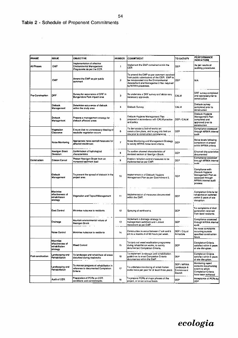
54
Table 2 - Schedule of Proponent Commitments
PHASE ISSUE OBJECTiVE NUMBER COMMITMENT TO SATISFY PERFORMANCE 'NOICATORS
All Phases EMP Implementation of effective Environmental Management 1
Implement the EMP contained within DEP
As per results of
Programme as per the CER CER auditing procedures
To amend the EMP as per Comment received
Amend the EMP as per public from public submissions of the CER. EMP to
EMP comment
2 be incorporated into the Environmental DEP NIA Assessment and Management Plan required by MRWA processes.
Pre-Cormtruction OAF Survey for occurrence of DRF in
3 To undertake a DRF survey and obtain any
CALM DRF survey completed and approved prior to Bungendore Park impact area necessary approvals. construction
Dieback Determine occurrence of dieback Dieback survey
Management within the study area 4 Dieback Survey. CALM completed prior to construction
Dieback Hygiene
Dieback Prepare a management strategy for Dieback Hygiene Management Plan - Management Plan
Management dieback affected areas 5 prepared in accordance with CALM practice DEP / CALM completed and and pohcy approved prior to
construction
Vegetation Ensure that no unnecessary clearing of To demarcate a limit-of-works on Compliance assessed
Clearance roadside vegelalion occurs 6 construction plans, and to peg this limit on DEP through MRWA internal site prior to construction commencing, audit
Noise Monitoring Appropriate noise control measures for
7 Noise Monitoring and Management Strategy
DEP Noise levels following completion of project affected residences to satisfy MRWA noise level criteria, within MRWA criteria
Neerigen Brook Confirmation of hydrological 8
To confirm channel characteristics of DEP
Channel characteristics Deviation characteristics devialed section of Neerigen Brook. documented
Construction Erosion Conrol Protect Neerigen Brook from an
9 Erosion / siltation control measures to be
DEP Compliance assessed through MRWA internal increased sediment load i mplemented as per EMP.
Compliance with Dieback Hygiene
Dieback To prevent the spread of dieback in the 10 Implementation of Dieback Hygiene
DEP Management Plan as Management project area Management Plan as per Commitment 5. assessed through
MRWA internal audit process
Maximise Completion Criteria for effectiveness of
V egetation and Topsoil Management Implementation of measures documented DEP
rehabilitation satisfied rehabilitation within the EMP. within 5 years of site strategy disruption.
No complaints of dust DusI Control Minimise nuisance to residents 12 Spraying of earlhwotks. DEP generation received
from local residents
Maintain environmental values of Implement a drainage strategy 10 Compliance assessed Drainage
Neerleen Brook 13 management sediment and nutrient DEP through MRWA internal
movement as per EMP. . audit
No noise complaints
Noise Control Minimise nuisance to residents 14 Construction to occur beiween 7 am and 6 DEP I City of occurring outside pm 10 a maximum of 60 hours per week. Armadale specified construction
hours
Maximiee effectiveness of To carry out weed eradication programme Completion Criteria
rehabilitation Weed Control 15 during rehabilitation works, to satisfy DEP satisfied within 5 years
strategy documented Completion Criteria, of site disruption.
Landscaping and To landscape and rehabilitate all areas To implement landscape and rehabilitation Completion Criteria Post-construction
Rehabilitation disturbed during roadworks 16 guidelines to meet Completion Criteria DEP satisfied within 5 years documented within the EMP. of site disruption.
Landscaping and To monitor progress of rehabilitation in
To undertake monitoring of rehabilitation DEP / MRWA Lan dscape &
Monitoring report contents documenting
Rehabilitation reference to documented Completion Criteria
17 works twice per year for at least three years. Environment eulent to which
Branch Completion Criteria have been achieved
Audit of CER Preparation of PCRs on CER
18 To prepare PCRs at major phases of the
DEP Acceptance of PCRs by conditions and commitments project or on an annual basis. DEP.
ecologia

55 MAIN ROADS WESTERN AUSTRALIA
Bedfordale Hill Duplication CER
8.0 SUMMARY AND CONCLUSIONS
The proposed Albany Highway Bedfordale Hill Section Duplication discussed in this CER arises from the cequirement for upgrading of this section of road in a context of an increasing volume of traffic and an existing high accident risk. The option of constructing a four lane divided highway has been selected as the preferred response to the requirement for roadworks, as it will satisfy projected traffic volumes, meets road design guidelines, and improves safety and transport efficiency. The specific alignment selected as the preferred option is considered to balance the environmental objectives of:
minimisation of intrusion into Bungendore Park;
avoiding where possible significant vegetation and buildings adjacent to the existing road;
minimisation of impact on Neerigen Brook; and
minimising requirements for land acquisition.
The project planning has occurred with regard to the social and biophysical environment of the study area. Possible environmental impacts were identified during the initial phases of project planning and this input has been included in development of the current proposal. The investigation of potential impacts has occurred simultaneously with engineering design, allowing for the development of a comprehensive environmental management plan for this project.
Public consultation and community involvement has been a feature of the development of this proposal. This has included newsletter delivery, public information days, formation of a Consultative Liaison Group, and direct liaison with residents adjacent to Albany Highway. The community is well informed about this proposal, and submissions and comment from members of the public and other interest groups has been utilised in the design process.
The main impacts of the project have been identified as:
intrusion into Bungendore Park;
requirements for clearing of exotic and native vegetation;
impact on water quality in Neerigen Brook;
noise; and
impact on cultural heritage and visual amenity.
Intrusion into Bungendore Park will occur due to requirements for cut to achieve road grades, and a requirement for earthworks. The project will not compromise System 6 values, objectives of the Darling Regional Park or biophysical characteristics in the area of impact. The Bungendore Park Management Committee has been involved in development of this proposal, which reflects the comments and concerns of this group.
Clearing of vegetation is an unavoidable impact of road development. This proposal has aimed to minimise clearing and is located within land identified for road requirements wherever possible. The native vegetation that will require clearing is typical of and well represented within the region.
Maintenance of water quality in Neerigen Brook has been carefully considered during the development of this proposal. The system of collecting road runoff to prevent it from entering the Brook upstream of the drainage reserve is the preferred option for drainage management. This strategy will ensure that contaminants from the road surface do not enter the water supply where it is a major water source for local residents. Construction and drainage management measures have been developed to prevent erosion and sedimentation within Neerigen Brook.
ecologia

56 MAIN ROADS WESTERN A USTRALIA
Bedfordale Hill Dupllcation CER
Noise levels are predicted to exceed the specified MRWA criteria for three residences within the study area. Noise mitigation measures will be implemented in these locations to ensure that road generated noise does not form a nuisance for the residenth.
The project requires removal of Willow Heights, a building with local heritage value. It Is anticipated that the building will be relocated to a position identified in conjunction with the City of Armadale. The road project will also cause alteration to the visual amenity of the alignment. However, the landscape plans developed for the project account for the existing character of the project area which is accounted for in the planting and rehabilitation programme. The rehabilitation strategy will ensure that revegetation of the alignment occurs, and that the visual impact of the project will be redressed within five years of project completion.
The impacts identified by the project team and through the guidelines produced by the EPA have all been addressed within the EMP incorporated within Section 6.0 of this CER. The EMP has been specifically designed to mitigate the predicted impacts of the proposal. The proponent has undertaken a number of comprehensive management commitments to ensure that the impact of the proposal Is minimised.
In conclusion, the planning and consultation for this project has been extensive, and a detail environmental management strategy developed to mitigate impacts. With implementation of the project as documented within this CER there should be no long term negative impact on the site, nor its inhabitants.
ecologia

57 MAIN Ros WESTERN AUSTRALIA
Bedfordale Hill Duplication CER
STUDY TEAM
The Albany Highway - Bedfordale Hill Section Duplication Consultative Environmental Review was planned, co-ordinated and executed by;
ecologia Environmental Consultants 165 Walcott Street Mt Lawley, WA, 6050
Project Staff
G.W. Connell BSc. (Hons) (Zool) Project Manager T.M. Gepp BA. (Hons) (Geog) Environmental Planner, Project Quality Manager M. Maier BSc. (Hons) (Zool) Senior Botanist M. Wells Dip Draft. Drafting
In addition;
Armadale City Council provided valuable data on the Draft Municipal Heritage Inventory.
Sinclair Knight Merz provided information on engineering design and public consultation for the Albany Highway - Bedfordale Hill Section Duplication Consultative Environmental Review.
ecologia

MAIN ROADS WESTERN AUSTRALIA Bedfordale Hill Duplication CER
REFERENCES
Atkins, K. (1995). Declared Rare and Priority Flora List. Unpublished flora listing prepared by the Department of Conservation and Land Management, Perth.
Beard, J.S. (1979) Vegetation Survey of Western Australia: The Vegetation of the Pinjarra Area. Map and Explanatory Memoir, 1: 250, 000 series. Vegmap Publications, Perth.
Beard, J.S. & Webb, M.J. (1974) Great Sandy Desert. Explan. Notes to Sheet 2, 1:1000000 Series, Vegetation Survey of W.A. UWA Press.
Cogger, H.G. (1992) Reptiles and Amphibians of Australia. Reed Books, New South Wales.
Department of Conservation and Environment (1983) Conservation Reserves for Western Australia as recommended by the Environmental Protection Authority - 1983: The Darling System - System 6 Part II: Recommentdations for Specific Localities. Department of Conservation and Environment, Western Australia.
Department of Conservation and Land Management (1992) Dieback Hygiene Manual
Department of Planning and Urban Development (1993a) The Natural Resources of the Darling Ranges. Darling Range Regional Park Supplementary Report No. 2. Department of Planning and Urban Development, Western Australia.
Department of Planning and Urban Development (1993b) Darling Range Regional Park and Landscape Study: A Proposal for a Darling Range Regional Park. Department of Planning and Urban Development, Western Australia.
Department of Planning and Urban Development (1993c) Visual Resource Assessment of the Darling Range Sub-Region. Darling Range Regional Park Supplementary Report No. 3. Department of Planning and Urban Development, Western Australia.
ecologia Environmental Consultants (1996) Albany Highway Bedfordale Hill Section Duplication Environmental Assessment and Draft Management Plan. Main Roads Western Australia, March 1996.
GB Hill & Partners (1994) Albany Highway Planning Study for Duplication Options at Bedfordale Hill. Main Roads Western Australia, November 1994.
Hames Sharley (1996) Albany Highway Bedfordale Hill Landscape Design Concept Main Roads Western Australia, February 1996.
Havel, J.J. (1975) Site Vegetation Mapping in the Northern Jarrah Forest (Darling Range): I. Definition of site-vegetation types. II. Location and mapping of site-vegetation types. Bull. For. Dept. West. Aust. No's 86 & 67.
Herring Storer Acoustics (1996) Road Duplication Bedfordale Hill - Albany Highway Acoustic Assessment. Main Roads Western Australia, February 1996.
Hoffman, N. & Brown, A. (1992) Orchids of South-West Australia. University of Western Australia Press.
L Millar & Associates (1995) Albany Highway, Bedfordale Hill Justification of Proposed Works. Main Roads Western Ausralia, May 1995.
ecologia

59
MAIN ROADS WESTERN A USTRALIA
Bedfordale Hill Duplication CER
Main Roads Western Australia (1992) Environmental Management Manual. Main Roads Western Australia, May 1992.
Main Roads Western Australia (1995) Topsoil Management in Conservation and Regeneration Draft Best Practice Manual: pp23 - 25.
Sinclair Knight Merz (1995a) Albany Highway Bedfordale Hill Section Planning Review Report. Main Roads Western Australia.
Sinclair Knight Merz (1995b) Albany Highway Bedfordale Hill Section Concept Plan Report on Submissions. Main Roads Western Australia, November 1995.
Sinclair Knight Merz (1996a) Albany Highway Bedfordale Hill Section Preliminary Design Report. Main Roads Western Australia.
Sinclair Knight Merz (1996b) Albany Highway Bedfordale Hill Section Preliminary Design Report on Submissions - Draft. Main Roads Western Australia, February 1996.
Sinclair Knight Merz (1996c) Albany Highway Bedfordale Hill Section Master Plan. Main Roads Western Australia, April 1996.
Soil & Rock Engineering (1996a) Albany Highway Bedfordale Hill Section Geotechnical Investigation Evaluation Report. Main Roads Western Australia, February 1996.
Soil & Rock Engineering (1996b) Albany Highway Bedfordale Hill Section Geotechnical Investigation Factual Report. Main Roads Western Australia, February 1996.
Speck, N.H. (1958) The Vegetation of the Darling-Irwin Botanical Districts. PhD Thesis, University of Western Australia.
ecologia

MAIN ROADS WESTERN A USTRALIA
Bedfordale Hill Dupilcation CER
APPENDIX A
EPA Guidelines for
Preparation of the CER
eco logia

EXPANSION AND WIDENING OF ALBANY HIGHWAY TO FORM A FOUR LANE DUAL CARRIAGEWAY FROM TRITON
CRESENT TO THE ROAD TRAIN ASSEMBLY AREA AT BEDFORDALE (1018).
GUIDELINES FOR THE ENVIRONMENTAL IMPACT ASSESSMENT DOCUMENT
(CONSULTATIVE ENVIRONMENTAL REVIEW)
Overview All environmental reviews have the objective of protecting the environment, and environmental impact assessment is deliberately a public process in order to obtain broad ranging advice. The review requires the proponent to describe the proposal, receiving environment, potential environmental impacts and the management of the issues arising from the environmental impacts, so that the environment is protected to an acceptable level.
Throughout the assessment, the Department of Environmental Protection (DEP) aims to assist the proponent to improve the proposal so that environmental impacts are minimised. The DEP also co-ordinates advice from relevant government agencies and the public about environmental matters during the assessment of the Consultative Environmental Review (CER).
Objectives of the CER To communicate clearly with the public and government agencies, so that the EPA can obtain informed comment to assist in providing advice to government.
To describe all aspects of the proposal adequately, so that the Minister for the Environment can consider approval of a well-defined project
To provide the basis for the environmental management programme, which should demonstrate that the environmental issues resulting from the proposal can be acceptably managed.
The contents of the CER should reflect these objectives.
Contents of the CER The text of the CER should be simple, concise, and referenced. This document would form the legal basis of the Minister for the Environment's approval of the proposal and should include a description ofll the components of the proposal.
The environmental management programme for the proposal should be developed in conjunction with the engineering and economic programs of the proposal. That is, the CER should be designed to be immediately useful at the start of the proposal, and the DEP recommends that an environmental management and audit programme be incorporated as a concluding part of the CER.
The textual content of the CER should include:
introduction to the proponent, the project and location;
the legal framework, decision making authorities and involved agencies;

description of the components of the proposal (road, borrow pits and associated earthworks) and identification of the potential environmental impacts;
description of the receiving environment which may be affected;
discussion of the key environmental topics (shown in the next section), including an assessment of their significance in comparison to relevant objectives, policies or standards;
discussion of the objectives for management of the issues, including commitments to appropriate action; and
a summary of the environmental management programme, including the key commitments, monitoring work and the auditing of the programme.
The EPA considers that the proponent should approach environmental management in terms of best practice, which includes:
development of an environmental policy;
agreed environmental objectives;
management practices to achieve the objectives;
involve the public as appropriate;
audit environmental performance against agreed indicators;
regular reporting to the EPA (or nominated agency);
commitment to a quality assured management system and continuous improvement; and
periodic review in conjunction with the EPA (or nominated agency).
Additional content requirements for the CER are included in the next section.
Key environmental topics The key topics can be determined from a consideration, called scoping, of the potential impacts of the proposal on the environment. The receiving environment includes social surroundings.
The CER should focus on the key topics for the proposal as agreed in consultation with the DEP and relevant government agencies. A description of the project component and the receiving environment should be directly included with, or referenced to, the discussion of the topic. The technical basis for measuring the impact and any specifications or standards for assessing and managing the topic should be provided.
The key topics identified at this stage and the assessment objectives include:
Biophysical
Environmental EPA objective topic
System 6 Area M80 The proposal should be consistent with Environmental Protection Authority Recommendations for M80.
Rare flora and fauna Rare flora and fauna (if any) should be protected in accordance with the requirements of the Wildlife Conservation Act.
Rethnant vegetation Regionally significant vegetation should be identified and protected.

Erosion Erosion due to vegetation clearing and increased run off should be identified and preventative measures installed
Dieback Identification of the dieback status in the area should occur with appropriate measures employed to ensure either containment, or maintenance as a dieback free area.
Vegetation Clearing Clearing of vegetation should be reduced as far as possible.
Water Supply Manage demand for water during construction from Nerrigin Brook so that environmental needs are meet.
Pollution
Dust Control Residential dwellings and conservation areas should be free from unacceptable impacts of dust
Contaminants from Stormwater collection and disposal systems should be designed to stormwater ensure that reduced or no contaminants reach Nerrigen Brook. Noise Noise at residential dwellings should comply with statutory
requirements both during construction and during operation.
Water quality in During construction turbidity of Neerigen Brook should be managed. Neerigen Brook
Hydrology of Hydrological regime of Neerigen Brook should be maintained at pre Neerigen Brook construction levels.
Environmental Those areas of Neerigen Brook affected by the proposal should have Values of Neerigen environmental values maintained or enhanced. Brook
Further key topics may be raised during the preperation of the CER, and on-going consultation with the DEP and relevant agencies is recommended. Minor issues which can be readily managed as part of normal operations may be briefly described. Information used to reach conclusions should be properly referenced, including personal communications. Assessments of the significance of an impact should be soundly based rather than unsubstantiated opinions, and the assessment should lead to a discussion of the management of the issue.
Public consultation A description should be provided of the public participation and consultation activities undertaken by the proponent in preparing the CER. It should describe the activities undertaken, the dates, the groups/individuals involved and the objectives of the activities. Cross reference should be made with the description of environmental management of the issues which should clearly indicate how community concerns have been addressed. Those concerns which are dealt with outside the EPA process can be noted and referenced.
Environmental management commitments The method of implementation of the proposal and all commitments made by the proponent in the CER become legally enforceable under the conditions of environmental approval issued by the Minister for the Environment. Commitments which address key environmental topics form a schedule to the Minister's environmental conditions and will be audited by the DEP.
The commitments should have the form of: the proponent (who) will prepare a plan or take action (what) to meet an objective, to the timing for its achievement (when), and to which

agencies will be consulted or to whose requirements, if not the DEP, the actionlplan will be prepared.
Other commitments show that the proponent is dedicated to good environmental management of the project, and the DEP expects that the proponent will audit these commitments by internal processes under an Environmental Management System. Though not subject to routine audit, the DEP may request that compliance with, or the in-house audit of, these commitments be demonstrated, so as to verify satisfactozy environmental performance. The commitments define the goals/objectives for the environmental management programme and procedures (the details of how the commitment will be met), which should be described in as much detail as possible. The DEP acknowledges that, with the implementation of best practice and continuous improvement for the project, the procedures may need to be modified, or added to, in regular updates to the environmental management programme. An example of a typical commitment is:
Issue Objectives NO Commitment When By Whom To whose satisfaction
CER Implement 1. Develop and Pre- MRD DEP, CALM etc. effective implement an construction CER effective and on-
CER going
Quality Assurance For QA purposes, these draft guidelines reflect the outcome of the Strategy meeting held on 10 May 1996 and endorsed at the managers meeting on 15 May 1996. They have also been checked against the Decision to Assess or Not Assess Form 2.
The draft guidelines were circulated with a 10 working day turn around time to the following parties, and the fmal guidelines been modified to reflect advice received:
Agriculture Western Australia
Department of Conservation and Land Management
Department of Transport
Main Roads Western Australia
National Parks and Nature Conservation Authority
Pollution Prevention Division, Department of Environmental Protection
Shire of Armadale
Water Corporation
4

MAIN R os WESTERN A USTRALIA
Bedfordale Hill Duplication CER
65
APPENDIX B
Plans of Road Alignment and
Land Acquisition
Requirements for the Albany
Highway Bedfordale Hill
Section Duplication
ecologia

P T88 20
1, w-f gg- gom, =:
LEGEND
LOT BOUNDARY
- --------- EXISTING ROADS
- EXISTING WATER/DRAINAGE FEATURE
PROPOSED ROAD
PROPOSED CUT/FILL BATTER
19
56
\I ALBANY b, / - - -- - -- - - - - - - - -
--- _-__1 _- 'ji• '-- 2 --:--- - >- _,
,,--
/f 1,',' / I',
II? i,I ,I ' I I
12 15 13 20 16
5
- - - -r-- - - -v -v -
-- I '- --.---- - ----
2
1
156 / 5
\- N
6 ---
6
hhIIhhIhIhIIhhhI hI JIhIIIIhhIhuuiuuuu 1 uuuuuuuutJ
0 20m 40 60 80 100
I I MAIN ROADS
MAIN ROADS WA I I [
Western Australia ALBANY HIGHWAY
L BEOFOROALE HILL SECTION SHEET 1

u-i
I.— u-i U.
uJ u-iL I- . z — <
U— I_n
I- I.- < 0 I—i o Z 00
0 Z L 2
u-J u-i
0 )( X O O
LU
LLJ
I,
/7 I,
7,
/7— S// p
/1 01
'0
/7
4
ItI
3000.000
S fl4P1GE
tlS
\\
'\
\'C ' '
---S S
\\
\
N..
I'
\ \ - o
-
IIWqL1'
$i!l_
1Lfii AI
ri

/ /
III \
'I
I,
II
rfl
12
/ II 11
/
100 III 103 I 6
BUNGENDORE PARK
LEGEND
LOT BOUNDARY
- --------- EXISTING ROADS
- - EXISTING WATER/DRAINAGE FEATURE
PROPOSED ROAD
._ PROPOSED CUT/FILL BATTER
N 48
500 4%
,_ -t- 2- ---------- r----------- ,':' / \ \ /
I I'' 39
37 36 / 35 /
40 '3
NEt SON STREET P11
38
II
33
t2000 111U1h111h11fl11h111U1h1h11111U11119
0 20m 40 60 80 100 L
MAIN ROADS WA
Western AustraIia1 LEOFOROALE HILL SECTION SHEET 3]
MAIN ROADS ALBANY HIGHWAY

33 19
\ \ \ \ 6 1H
\\
\
12
9
A, "l
a,1 32 -
II -- - - - - --_ - ---;i: -- - ---
- - - - & - - -L
- PT? - 4 1 - -------- --------------- -- ----- ---
,___ ------ -,-- - - - Pie54
-------, \_'
I -- - LEGEND
51 53 - 51 LOT BOUNDARY
\ \ - EXISTING ROADS \ \ \ \
52 — - — EXISTING WATER/DRAINAGE 1FEATURE \\ \ \ PROPOSED ROAD \ \\ 0
yyt: PROPOSED CUT/FILL BATTER
50
ALBA
I -
21
t2000 IIIIIIIIIIIIII1IIIIIIIIIIIIIIIIIIIIIII1IIIIIIIIIIII 0 20m 40 60 80 100
) L P12
2u
LA
4)
-
- - II
ill' - -= ------- -- - --
II I I -
-
-,- \ ,
1 I MAIN ROADS
MAIN ROADS WA \ \ I I I ALBANY HIGHWAY Western Australia
j BEDFORDALE HILL SECTION SHEET 4

102
PT CAN LOC 413
LEGEND
LOT BOUNDARY
- --------- EXISTING ROADS
- - EXISTING WATER/DRAINAGE FEATURE
PROPOSED ROAD
PROPOSED CUT/FILL BATTER
jRR•___U- PT LOC 465
—I
-
410
12000 IIIIIhhhIIIhhIIIIIIhIIIIIIhIIIIIIIhIIIIIIIIIIIhIIhI 0 20m 40 60 80 100 L
[MAIN ROADS WA
Western AustraIia1 BEOFOROALE HILL SECTION SHEET 5 ]
MAIN ROADS
L
ALBANY HIGHWAY
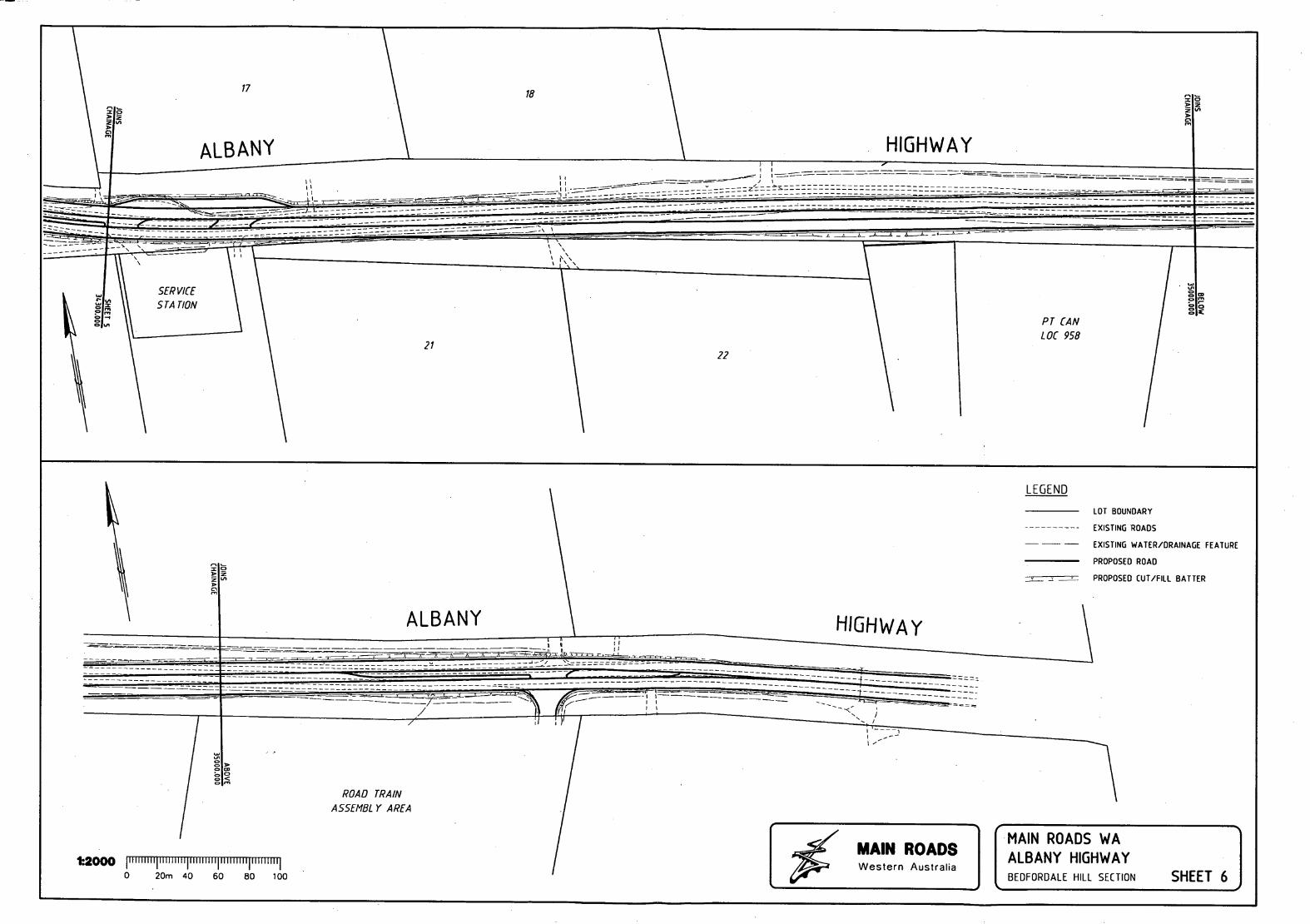
17
18
\ I ALBANY HIGHWAY -- --
I I - - - ----------------- -------------------
----- --------------- --------- ::
-- ' \\ I JU \ I I
PT CAN LOC 958
21
ALBANY
22
LEGEND
HIGHWAY
LOT BOUNDARY
- --------- EXISTING ROADS
- - - EXISTING WATER/DRAINAGE FEATURE
PROPOSED ROAD
PROPOSED CUT/FILL BATTER
TTEI
ROAD TRAIN AS5EMBL Y AREA
12000 jIlli 111111 11 11111 111111111111111111111 IjIl II 0 20m 40 60 80 100 [
[MAIN ROADS WA
Western AustraIia1 BEDFOROALE HILL SECTION SHEET 61
MAIN ROADS ALBANY HIGHWAY

MAIN ROADS WESTERN AUSTRALIA
Bedfordale Hill Dupilcation CER
72
APPENDIX C
Summary of
Public Consultation
Programme
ecologia

73
MAIN ROADS WESTERN A USTRALIA Bedfordala Hill Duplication CER
C1.0 SUMMARY OF PUBLIC CONSULTATION PROGRAMME
C1.1 INTRODUCTION
A major public consultation programme has been undertaken to understand the community concerns and to address those concerns within the project design wherever possible. The programme has included:
Consultation on the Concept Plan;
Consultation on the Preliminary Design; and
Establishment of a Community Liaison Group.
The approvals process for the project under the Environmental Protection Act 1986 also provides additional opportunity for public input into the development and implementation of the Albany Highway Bedfordale Hill Section project.
Newsletters and submission summaries are included in Appendix E.
C1.2 CONSULTATION PROGRAMME
C1.2.1 Consultation On The Concept Plan
The public consultation programme has been carried out by Sinclair Knight Merz, and has incorporated the delivery of a newsletter to all householders and businesses in the area, explaining the project and requesting input from the community. The newsletter is included in Appendix E.
This phase of consultation included a static display at the Armadale Shopping City from 6 November 1995 to 17 November 1995. An open day on 11 November 1995 was staffed by representatives of Sinclair Knight Merz and MRWA.
A total of 54 submissions were received during this stage by Sinclair Knight Merz. Of these, 42 were generally supportive of the project, giving suggestions and seeking clarification on specific issues including property acquisition; amenity; noise; water quality; and median openings. Twelve submissions were opposed to the project stating various reasons, including the suggestion that trucks go via Jarrahdale as opposed to Bedfordale.
The outcome and recommendations of the report concluded that there was wide community support for the project, with a number of specific issues requiring resolution in the Preliminary Design stage. The issues identified through the first stage of consultation were:
Land acquisition;
Landscape;
Water access and quality;
Property access; and
Median break locations.
The results of the consultation process have been summarised in a separate report by Sinclair Knight Merz (1995b).
ecologia

74 MAIN ROADS WESTERN AUSTRALIA
Bedfordale Hill Duplication CER
C1.2.2 Consultation On The Preliminary Design
This phase of the consultation programme replicated the first phase, with preliminary design plans available for public comment. A staffed display was held between 5 February and 17 February 1996, with open days on the 8th, 10th and 15th of February 1996, staffed by representatives of MRWA and Sinclair Knight Merz. A newsletter was delivered (Appendix E) advising householders of the display, which was also advertised in the local newspaper.
A total of 58 responses were received, 55 of which were generally supportive of the project but seeking clarification on specific issues. Three submissions were opposed to the project for various reasons, including the suggestion that trucks should go via Jarrahdale rather than Bedfordale, obviating the need for the duplication project.
The biggest concerns for residents adjacent to the Highway were identified as:
Driveways to be made good on completion;
Water supply and quality;
Median break locations;
Bedfordale Hill Road banned turns;
Median U-turns for trucks; and
Saving existing trees.
For residents away from the Highway, the main concerns were identified as:
Bedfordale Hill Road banned turns;
Springfield Road; and
Arrester Bed.
The results of the consultation process have been summarised in a separate report by Sinclair Knight Merz (1996b).
C1.2.3 Outcomes of Consultation Programme
Recommendations to be accounted for during the detailed design stage of the project were derived from a review of the submissions, together with feedback from open days, and additional telephone conversations. The recommendations are:
Water Supply and Quality: Water supply requirements of residents be investigated and a plan for water supply continuation during construction be developed. A requirement to ensure that construction and Brook relocation strategies and techniques minimise adverse impacts on water quality, including siltation.
Bedfordale Hill banned turns: City of Armadale to be provided with details of opponents to banned turns.
Median break locations and U-turns for trucks: median breaks to be revised for eight locations, with allowances for embayments to allow truck U-turns.
ecologia

75 MAIN ROADS WESTERN A USTRALIA
Bedfordale Hill Duplication CER
Save existing trees: opportunities to use retaining walls where practical to save trees. Design team to have an objective of retaining as many existing trees as possible.
Springfield Road: design team to add a merging lane for the left turn from Springfield Road to Albany Highway.
Arrester Bed: MRWA review the need for an arrester bed.
Other Detailed Issues: To be accommodated in the design process where possible.
C1.3 COMMUNITY LIAISON GROUP
A Community Liaison Group (CLG) consisting of 10 residents and landowners adjacent to and close by Albany Highway was established for the Master Planning Stage of the project. This group first met on the 7 December 1995, and met every six weeks for the Master Planning stage. The CLG has provided important local experience, expertise and information on traffic, social, environmental, water, drainage and site conditions in the study. area. The information gathered from the CLG meetings has been utilised to finalise the Master Plan for the duplication design of the Albany Highway Bedfordale Hill Section.
C1.4 BUNGENDORE PARK
The Bungendore Park Management Committee and the Armadale Wildflower Society (Inc.) have submitted requests for consideration during planning for this project. These are:
the retention of Nuytsia floribunda trees at the Albany Highway entrance to Bungendore Park;
the provision of a break in the median for access into Bungendore Park, especially for the access of emergency vehicles in the case of bushfire;
a request that the rehabilitation of the road reserve and medians be carried out using local indigenous species;
inclusion of an entry statement to Bungendore Park from Albany Highway as a component of the overall landscape treatment; and
a population of King Skinks Egernia kingli is reported within the impact area by the Bungendore Park Management Committee, which wishes to organise a relocation strategy for the population affected by roadworks.
The rehabilitation strategy was developed on the basis of retaining the existing character of the Bedfordale Hill Section of Albany Highway. As this includes numerous exotic vegetation species, these have been included in the landscape design. However, areas containing remnant vegetation, particularly the Bungendore Park boundaries will be revegetated using native vegetation.
A median break has been provided at the entrance to Bungendore Park.
MRWA will provide funding to assist the Bungendore Park Management Committee in developing and implementing a relocation programme for King Skinks Egernia king/i within the impact area of the roadworks.
ecologia

76 MAIN R oos WESTERN A USTRAUA
Bodfordaie Hill Duplication CER
C1.5 ADDITIONAL CONSULTATION
C1.5.1 City of Armadale
Councillors and officers of the City of Armadale have been kept fully briefed on the project, and have had substantial input into decisions on key issues. An issue raised by the City of Armadale following the release of the Master Plan for the project, is the philosophy behind the drainage strategy, and the issue of kerbing.
The concerns of the City of Armadale are as follows:
that the piping of stormwater drainage and its discharge into Neerigen Brook at two points below Bedfordale Hill Road will concentrate pollutants in Neerigen Brook downstream of Albany Highway.
that the piping of stormwater will, due to increased volumes of water and greatly reduced delivery time, create a significant potential for flooding in the Neerigen and Wungong floodplains of Armadale.
that the kerbing of the road without provision of an emergency lane will contribute to the potential for serious collisions on the road which will be unable to leave the carriageway in the event of breakdown, or emergency braking.
The City of Armadale in recognising the need to protect water quality of Neerigen Brook for domestic users, considers that the alternative of providing reticulated scheme water to necessary properties requires investigation. MRWA however has no jurisdiction over the Water Corporation's plans to provide reticulated scheme water to domestic users, and cannot allow funding for this to occur from the MRWA budget.
The drainage strategy documented in Section 3.0 is the preferred option of MRWA. However, both options are further discussed in Section 6.0.
Barrier kerbing was originally proposed for the Bedfordale Hill Section duplication, in keeping with kerbing used for other similar roadways in the Metropolitan area. However, in view of the request of the City of Armadale, MRWA will use semi-mountable kerbing for the entire project, to allow vehicles to leave the road pavement if necessary.
C1.5.2 Miscellaneous Issues
A number of additional issues were raised during the consultation process, and have been incorporated into the project design.
Liaison with the Armadale Primary School highlighted the need to incorporate bus bays into the road design. Consequently bus bays are to be provided at all intersections and at selected U-turn locations for school buses operating along Albany Highway
Liaison with the Volunteer Fire Service has been undertaken to ensure appropriate access to all water supplies and to Bungendore Park is accommodated within the road design.
ecologia

MAIN ROADS WESTERN A USTRALIA Bedfordale Hill Dupilcation CER
77
APPENDIX D
Vegetation List for the Albany
Highway Bedfordale Hill
Section Duplication Project
Area
ecologia

78 MAIN ROADS WESTERN A USTRALIA
Bedfordale Hill Dupilcation CER
Appendix D: Vegetation list for the Bedfordale Hill project area.
Species Name Common Name Form
Acacia puichella Prickly Moses Shrub Acacia urophylla (Wattle) Shrub Agonis linearifolia. (Peppermint) Shrub Aira caryophylla Silvery Hair Grass Introduced Grass Allocasuarina fraseriana Sheoak Tree Banksia grandis Bull Banksia Tree Bossiaea ornata (Pea) Shrub Briza maxima Quaking Grass Introduced Grass Clematis pubescens - Climber Dampiera linearis Common Dampiera Herb Dianella revoluta (Lily) Herb Dryandra sessilis Parrot Bush Shrub Dryandra nivea Couch Honeypot Shrub Eucalyptus calophylla Marri Tree Eucalyptus marginata Jarrah Tree Eucalyptus rudis Flooded Gum Tree Hakea amplexicaulis Prickly Hakea Shrub Hakealissocarpha Honey Bush Shrub Hakea trifurcata - Shrub Hakea undulata - Shrub Hibbertia hypericoides Guinea Flower Shrub Hyalosperma cotula (Daisy) Introduced Herb Kennedia coccinea Coral Vine Climber Lasiopetalum floribundum - Shrub Lepidosperma purpurea (Sword Sedge) Sedge Lepidosperma tenue (Sword Sedge) Sedge Leucopogon capitellatus - Shrub Leucopogon propinquus - Shrub Leucopogon verticillatus Tassell Shrub Shrub Macrozamia riedlei Zamia Shrub Melaleuca sp Paperbark Shrub Mesome/aena tetragona Semaphore Sedge Sedge Opercularia echinocephala - Herb Paspalum dilatatum Paspalum Introduced Grass Pentapeltis peltigera - Herb Pericalymma ellipticum - Shrub Petrophile striata - Shrub Phyllanthus calycinus - Shrub Restionaceae sp - Rush-like Herbs Thysanotus sparteus - Herb Ursinia anthemoides - Introduced Herb Watsonia bulbillifera Bugle Lily Introduced Plant Xanthorrhoea preissii Blackboy Shrub Xanthosia candida - Herb
NB: Names in brackets are general names for that genus, or in some cases family, where a specific common name is not available.
ecologia

MAIN ROADS WESTERN A USTRALIA
Bedfordale Hill Duplication CER
79
APPENDIX E
Suggested Revegetation
Flora Species List
ecologia
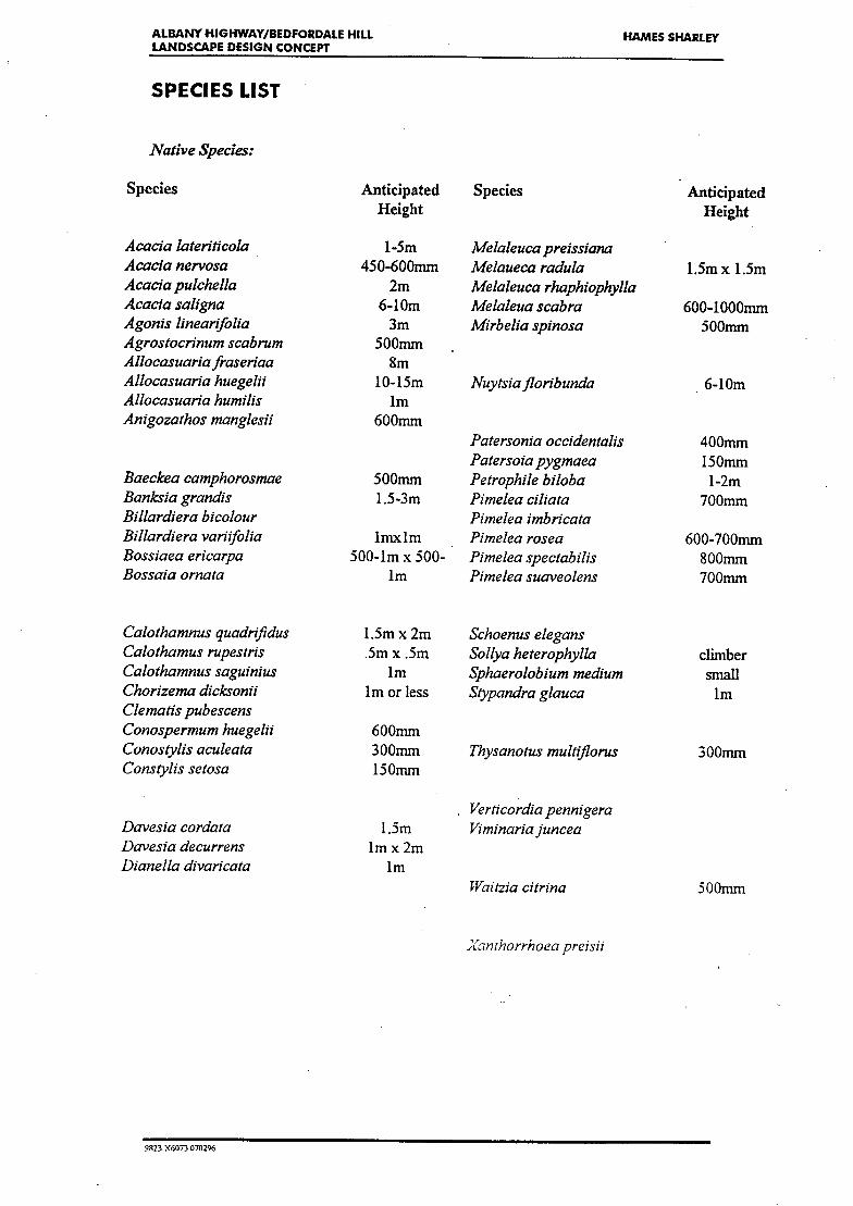
ALBANY HIGHWAY/BEDFORDALE HILL
HAMES SHARLEY LANDSCAPE DESIGN CONCEPT
SPECIES LIST
Native Species:
Species Anticipated Species Anticipated Height Height
Acacia lateriticola 1-5m Melaleucapreissiana Acacia nervosa 450-600mm Melaueca radula 1.5m x 1.5m Acaciapuichella 2m Melaleuca rhaphiophylla Acacia saligna 6-10m Melaleua scabra 600-1000mm Agonis linearfolia 3m Mi rbelia spinosa 500mm Agrosfocrinum scabrum 500mm Allocasuariafraseriaa Sm Allocasuaria huegelii 10-15m Nuytsiafloribunda 6-10m Allocasuaria humilis im Anigozathos mangles/i 600mm
Patersonia occidentalis 400mm Patersoia pygmaea 150mm
Baeckea camphorosmae 500mm Petrophile biloba 1-2m Banks/a grand/s 1.5-3m Pimelea ciliata 700mm Billardiera b/colour Pimelea imbricata Billardiera varifolia lmxlm Pimelea rosea 600-700mm Bossiaea ericarpa 500-1m x 500- Pimelea specrabilis 800mm Bossaia ornata im Pimelea suaveolens 700mm
Calothamnus quadrifidus 1.5m x 2m Schoenus elegans Calothamus rupestris .5m x .5m Sollya hererophylla climber Calothamnus saguinius im Sphaerolobium medium small Chorizema dicksonif Im or less Stypandra glauca im Clematis pubescens Conospermum huegelii 600mm Conosylis aculeata 300mm Thysanotus multifiorus 300mm Constylis setosa 150mm
Verticordia pennigera Davesia cordata 1.5m Viminariajuncea Davesza decurrens 1 m x 2m Dianella divaricata im
Waitzia citrina 500mm
Xanthorrhoea preisi!
9923 X6073 070296

ALBANY HIGHWAY/BEDFORDALE HILL HAMES SHARLEY LANDSCAPE DESIGN CONCEPT
Exotic Species:
Species:
Araucaria heterophylla Brachychiton Acerifolius Choisya ternata Cotoneaster conspicuous Erythina indica Gazonia spp Grevillea crithmifolia Grevillea crithmifolia (prostate form) Hymenosparum flavium Jiniperus conferta Latana caniara Lonicera periclymenum Myoporum parviflorum Pmus radiata Pluinbago capensis Populus nigra (Italica) Schinus molle Tecomaria capensis
Anticipated Height
30m 10-30m 1-1.25m 450mm
lOm 300mm
im 300-1000mm
300mm 18-27m
1 .5-2.5m 30m 6m
2-3m
LiBRj, DEPARTMENT OF ENVIRONV.
-ITA P!CJTECTION WESTR,4LIA ck11E 141 ST. GEORGES Tv,~R,4,CE, PERTH
9823 X6073 0-02-06