Equivalent Linear Site Response Analyses of Kathmandu Valley

City of Edmonton
Valley Line-Stage 1
Light Rail Transit (LRT) Project
Bylaw 7188
Site Location Study
Final Report
Prepared for:
City of Edmonton
Transportation Services
LRT D and C
Edmonton, Alberta
Prepared by:
Spencer Environmental
Management Services Ltd.
Edmonton, Alberta
Under contract to:
AECOM
Connected Transit Partnership
Edmonton, Alberta
Project Number EP - 522
July 2013
Spencer Environmental
July 2013 Valley Line - Stage 1 Site Location Study
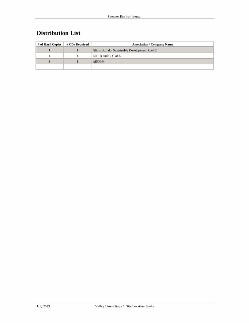
Distribution List
# of Hard Copies # CDs Required Association / Company Name
1 1 Glinis Buffalo, Sustainable Development, C of E
6 6 LRT D and C, C of E
3 1 AECOM


Spencer Environmental
July 2013 Valley Line - Stage 1 Site Location Study Page E1
Executive Summary
The purpose of the Valley Line-Stage 1 Site Location Study is to detail the social,
financial, environmental and institutional constraints that make location of the proposed
project within the North Saskatchewan River Area Redevelopment Plan (Bylaw 7188)
boundaries, essential. This report also provides a detailed examination of project
conformance to the goals, objectives and policies of Bylaw 7188.
Any LRT extension from downtown to the community of Mill Woods must cross the
North Saskatchewan River. Any such crossing within City limits would require
development within Bylaw 7188 boundaries. From 2008-2009, the City of Edmonton
Transportation Department undertook a comprehensive, multi-step decision-making
process to identify a recommended corridor for the LRT Southeast Extension. Numerous
alignments were initially considered and subjected to a fatal flaw analysis. From these,
four proposed alignments were analyzed more closely, using weighted criteria approved
by City Council; public input was sought throughout the process. The process culminated
in identification of the “Connors Road Corridor” as the recommended corridor, followed
by City Council approval of that corridor in December 2009. Planning continued. In
January 2011, Council approved a concept plan for the southeast LRT and in June 2011,
approved funding for preliminary design.
In April 2013, the preliminary design exercise culminated in further refinement of the
alignment and preliminary design of various essential component project elements (such
as track, stop, and utilities, including stormwater drainage infrastructure). The final
product is referred to as the Reference Design. The City has adopted a P3 model to
deliver detailed design, construction, finance, operation and maintenance for the project.
Partial project funding has been secured through the P3 Canada Fund program. The
Reference Design will be carried forward into the P3 Procurement Phase.
The project as a whole, and therefore all component parts, must be located in the river
valley as a result of the following constraints and, in doing so, provides the following
benefits.
Social: The 2008/2009 corridor selection process indicated that this
corridor was preferred when compared to alternatives on the basis
that it is able to maximize the use of existing corridors while
respecting neighbourhoods, parkland and the North Saskatchewan
River Valley. Specifically, selection criteria included impacts to
recreational accessibility, the acquisition of public lands, physical
barriers to local residents and potential impacts of noise and
vibration within 150 m. More recently, additional analysis and
planning has identified a conceptual and now a more refined
alignment within that corridor that confirms compatibility with
these criteria and many social benefits, including a river valley stop
that will provide direct and easy pedestrian access to many events,
facilities and homes.

Spencer Environmental
July 2013 Valley Line - Stage 1 Site Location Study Page E2
Financial: The costs associated with the Connors Road Corridor compared
favourably to those of another considered corridor.
Environmental: Corridor selection criteria included potential impacts to parks,
riparian habitat and natural areas and, ultimately, the proposed
corridor was determined to have relatively few potential impacts on
such resources because it is largely situated within, or immediately
adjacent to, developed areas, thus, adhering to the positive planning
principle of clustering development. More specifically, the
proposed alignment has sought to minimize environmental impacts
and project infrastructure has been designed to provide for wildlife
movement, to protect aquatic resources and to ensure protection of
existing drainage function and infrastructure in the area.
Institutional: The Valley Line-Stage 1 selected corridor meets relevant criteria
pertaining to land use such as promoting compact urban form,
serving an area of greater density in comparison to alternate
alignments, providing a direct connection between downtown and
Mill Woods, and balancing service between established
neighbourhoods, infill opportunities and planned residential
communities. The Reference Design within the river valley
provides an enhanced connection through placement of a station
that directly links several public amenities to the City’s LRT
network.
This Site Location Study concludes that the location and preliminary design of the river
valley components of the Valley Line-Stage 1 LRT conform to the goals, and applicable
objectives and policies of Bylaw 7188.

Spencer Environmental
July 2013 Valley Line - Stage 1 Site Location Study Page i
Table of Contents
1.0 INTRODUCTION .................................................................................................. 1
2.0 RECOMMENDED CORRIDOR AND ALIGNMENT ....................................... 2
3.0 THE PROPOSED PROJECT .............................................................................. 4
3.1 Project Overview ................................................................................................ 4 3.2 Reference Design River Valley Alignment ........................................................ 4 3.3 Key Project Components .................................................................................... 6
4.0 CONSTRAINTS ANALYSIS .............................................................................. 8
4.1 Social Constraints ............................................................................................... 8 4.2 Financial .............................................................................................................. 8
4.3 Environmental Constraints.................................................................................. 8
4.3.1 Institutional Constraints .................................................................................. 9
5.0 CONFORMANCE WITH NSR VALLEY ARP .............................................. 10
5.1 Major Goals ...................................................................................................... 10
5.2 Parkland Development Objectives .................................................................... 11 5.2.1 Parkland Development Policies .................................................................... 13
5.3 Environmental Protection Objectives ............................................................... 17
5.3.1 Environmental Protection Policies ................................................................ 17 5.4 Transportation Objectives ................................................................................. 18
5.4.1 Transportation Policies ................................................................................. 19 5.5 Major Facility and Natural Resource Development Objectives ....................... 19
5.5.1 Major Facility and Natural Resource Development Policies ........................ 20 5.6 Agricultural Land Use Objectives .................................................................... 22
5.6.1 Agricultural Land Use Policies ..................................................................... 22 5.7 Residential Land Use Objectives ...................................................................... 22
5.7.1 Residential Land Use Policies ...................................................................... 23
5.8 Central Area Land Objectives ........................................................................... 23 5.8.1 Central Area Land Use Policies .................................................................... 23
5.9 Upland Areas .................................................................................................... 25
6.0 CONCLUSIONS ................................................................................................. 26
7.0 REFERENCES .................................................................................................... 27
7.1 Literature Cited ................................................................................................. 27
7.2 Personal Communication .................................................................................. 27
APPENDIX A: SOUTHEAST LIGHT RAIL TRANSIT DOWNTOWN TO MILL
WOODS .......................................................................................................................... A1
List of Figures
Figure 1. Project Setting and Components ........................................................................ 5

Spencer Environmental
July 2013 Valley Line - Stage 1 Site Location Study Page ii
List of Tables
Table 1. Detailed Corridor Evaluation Undertaken in 2009. ............................................. 3 Table 2. Additional Essential Project Components ........................................................... 6

Spencer Environmental
July 2013 Valley Line - Stage 1 Site Location Study Page 1
1.0 INTRODUCTION
Development within North Saskatchewan River Valley Area Redevelopment Plan
(NSRV ARP) (Bylaw 7188) boundaries triggers the requirements for an environmental
review, and, a Site Location Study (SLS) pursuant to Bylaw Section 3.5.3. City of
Edmonton, Sustainable Development has determined that the appropriate level of
environmental review for the Valley Line is an Environmental Impact Screening
Assessment (EISA). The EISA for the proposed alignment, completed in July 2013,
identifies potential bio-physical, socio-economic and historic impacts that may result
from the project and recommends mitigation measures and best management practices to
reduce such impacts.
This Site Location Study has been prepared as a companion document, in compliance
with Bylaw 7188 requirements. The Site Location Study considers only the portion of
the Valley Line-Stage 1 that is situated within Bylaw 7188 lands. The purpose of this
Valley Line-Stage 1 Light Rail Transit (LRT) Site Location Study is to detail the social,
financial, environmental and institutional constraints that make locating this southeast
LRT line and associated infrastructure within Bylaw 7188 boundaries essential. Bylaw
7188 Site Location Studies are intended to document why locating the proposed project
within NSRV ARP lands is essential and why the specific selected project location is
essential. In the case of the Valley Line-Stage 1 LRT, the first point is easily resolved by
noting that any LRT line designed to directly connect Edmonton’s downtown to
Edmonton’s southeast quadrant, as has been mandated by City Council, necessarily
involves a new crossing through the North Saskatchewan River Valley. That crossing
may or may not use an existing transportation corridor. The second point requires closer
examination and is, therefore, the focus of this report. This SLS also examines ways in
which the proposed project conforms to Bylaw 7188 goals, objectives and policies.

Spencer Environmental
July 2013 Valley Line - Stage 1 Site Location Study Page 2
2.0 RECOMMENDED CORRIDOR AND ALIGNMENT
Following is a synopsis of the planning processes undertaken to arrive at the
recommended corridor and alignment that is the subject of this SLS and the companion
EISA.
City of Edmonton (the City) LRT Network Plan identified a six legged LRT system to
serve all sectors of the city. Following approval of the Network Plan, an important
planning component was the evaluation of several alternative SE LRT corridors to arrive
at a recommended corridor. That study, initiated in late 2008 and led by City of
Edmonton Transportation Department, involved a multi-step approach and a structured
decision-making process that engaged with a full range of City departments, the public
and citizen stakeholder groups.
The process included the following key, sequential project activities: development of
criteria to compare potential corridor options against one another; identification of a wide
range of corridor options; basic design layouts of corridor options; technical analysis on
key project challenges; a Level 1 evaluation (conceptual screening), of all identified
corridors (i.e., an initial fatal flaw analysis); a Level 2, detailed evaluation, of the four
most suitable corridors; and a final, more detailed analysis of the resultant two most
promising corridors (CH2MHill 2009).
Level 1 began with numerous corridors and lead to identification of the following four
potential corridors:
High Level (CPR) Corridor
High Level (Whyte Avenue) Corridor
Connors Road Corridor
Dawson Bridge Corridor
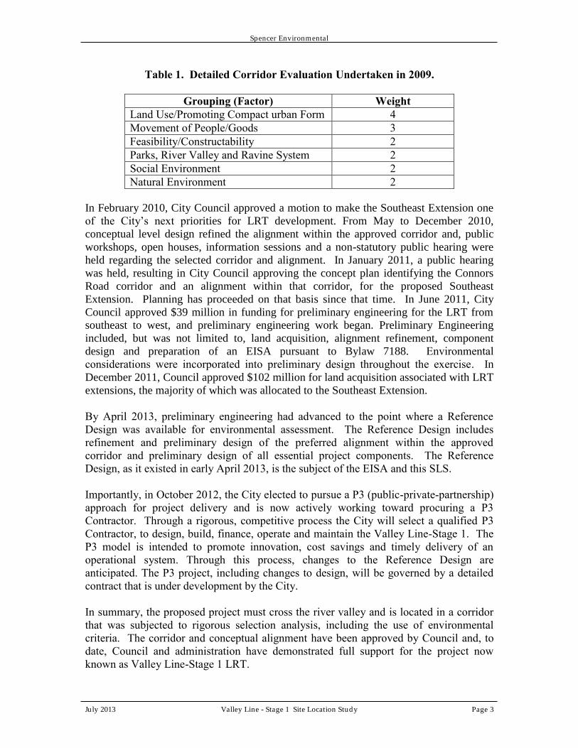
Level 2 evaluated the four corridors according to six weighted factors (Table 1). Each
factor had numerous well-defined criteria. All criteria and (factor weights) were
approved by City Council in December 2008. Level 2 analysis identified Connors Road
and Dawson Bridge as the two most suitable corridors. These two options were then
further analysed at the level of each criterion. Analysis included consideration of earlier
public input on these corridors. The final result, in autumn 2009, was identification of
the Connors Road Corridor as the recommended corridor. The full evaluation process is
documented in detail in CH2MHILL (2009) and is appended here (Appendix A).
Following a public hearing, that corridor was approved by Council in December 2009.
Spencer Environmental
July 2013 Valley Line - Stage 1 Site Location Study Page 3
Table 1. Detailed Corridor Evaluation Undertaken in 2009.
Grouping (Factor) Weight
Land Use/Promoting Compact urban Form 4
Movement of People/Goods 3
Feasibility/Constructability 2
Parks, River Valley and Ravine System 2
Social Environment 2
Natural Environment 2
In February 2010, City Council approved a motion to make the Southeast Extension one
of the City’s next priorities for LRT development. From May to December 2010,
conceptual level design refined the alignment within the approved corridor and, public
workshops, open houses, information sessions and a non-statutory public hearing were
held regarding the selected corridor and alignment. In January 2011, a public hearing
was held, resulting in City Council approving the concept plan identifying the Connors
Road corridor and an alignment within that corridor, for the proposed Southeast
Extension. Planning has proceeded on that basis since that time. In June 2011, City
Council approved $39 million in funding for preliminary engineering for the LRT from
southeast to west, and preliminary engineering work began. Preliminary Engineering
included, but was not limited to, land acquisition, alignment refinement, component
design and preparation of an EISA pursuant to Bylaw 7188. Environmental
considerations were incorporated into preliminary design throughout the exercise. In
December 2011, Council approved $102 million for land acquisition associated with LRT
extensions, the majority of which was allocated to the Southeast Extension.
By April 2013, preliminary engineering had advanced to the point where a Reference
Design was available for environmental assessment. The Reference Design includes
refinement and preliminary design of the preferred alignment within the approved
corridor and preliminary design of all essential project components. The Reference
Design, as it existed in early April 2013, is the subject of the EISA and this SLS.
Importantly, in October 2012, the City elected to pursue a P3 (public-private-partnership)
approach for project delivery and is now actively working toward procuring a P3
Contractor. Through a rigorous, competitive process the City will select a qualified P3
Contractor, to design, build, finance, operate and maintain the Valley Line-Stage 1. The
P3 model is intended to promote innovation, cost savings and timely delivery of an
operational system. Through this process, changes to the Reference Design are
anticipated. The P3 project, including changes to design, will be governed by a detailed
contract that is under development by the City.
In summary, the proposed project must cross the river valley and is located in a corridor
that was subjected to rigorous selection analysis, including the use of environmental
criteria. The corridor and conceptual alignment have been approved by Council and, to
date, Council and administration have demonstrated full support for the project now
known as Valley Line-Stage 1 LRT.

Spencer Environmental
July 2013 Valley Line - Stage 1 Site Location Study Page 4
3.0 THE PROPOSED PROJECT
3.1 Project Overview
Hereafter, for purposes of this report, the section of the Valley Line-Stage 1 LRT situated
within Bylaw 7188 boundaries, will be referred to as the “proposed alignment” (Figure
1). Within Bylaw 7188 boundaries, the proposed alignment is approximately 1.6 km in
length, and includes a single stop, situated immediately west of the Muttart Conservatory.
The river crossing component of the proposed alignment will be situated along the
existing alignment of the Cloverdale pedestrian footbridge. This new LRT bridge will
replace the existing footbridge and itself accommodate pedestrian traffic. The new LRT
bridge is viewed by Urban Planning and Environment as a new corridor across the North
Saskatchewan River (Clyburn, pers. comm.).
Preliminary design is now complete for the entire Valley Line-Stage 1, including the
components within the river valley. Design of some components is advanced further than
others and the river valley LRT components are among those that are furthest advanced.
This Reference Design will be carried forward and provided to the P3 Contractor. The
P3 contract will specify acceptable Reference Design variance tolerances and will set out
spatial, temporal, structural and methodological standards and specifications. Any
proposal outside of those tolerances or not meeting standards will be subject to review
and approval following standard City approval processes, including environmental
review processes.
3.2 Reference Design River Valley Alignment
From the north, the proposed Valley Line–Stage 1 alignment travels below grade
(underground) parallel to 95th Street entering Bylaw 7188 boundaries immediately south
of the 95th Street terminus through a tunnel, daylighting on the north valley wall via a
portal structure, where it becomes an elevated corridor. The proposed alignment then
travels south through Louise McKinney Park, crossing the North Saskatchewan River
along the existing corridor of the Cloverdale pedestrian bridge, and enters Henrietta Muir
Edwards Park south of the river. The proposed alignment continues southward as an
elevated structure, crosses 98th Avenue as a bridge, and transitions to an at-grade track
south of 98th Avenue, at a stop immediately west of the Muttart Conservatory (Muttart
Stop). The proposed alignment continues southwest after the Muttart Stop, connecting
with Connors Road and travelling east up the valley wall. The proposed alignment
travels at-grade north of a realigned Connors Road, exiting the Bylaw 7188 boundaries
westward (Figure 1).
The proposed alignment is situated within the “Central Area” as defined by Bylaw 7188.
The Central Area includes all Bylaw 7188 boundary lands between the High Level
Bridge and Dawson Bridge; these lands also include Mill Creek Ravine. Significant
features of the Central Area considered in this Site Location Study include Louise
McKinney Park, Henrietta Muir Edwards Park, Dove Hill/Gallagher Park, Muttart
Conservatory, Edmonton Ski Club, the Edmonton Queen Riverboat, the Cloverdale

LOUISE MCKINNEYPARK
HENRIETTA MUIREDWARDS PARK
MUTTARTCONSERVATORY
PARK
GALLAGHERPARK
Connors Rd.
Jasper
Ave.
Grierson Hill
Rowland Rd.
101a Ave.
95 St.
98 Ave.
North SaskatchewanRiver
96a
St.
95 S
t.
Cameron Ave.
Scon
a R
d.
Edmonton QueenRiverboat
MILL CREEKRAVINE PARK
Cloverdale
Tunnel
PortalStructure
MuttartStop
New Connors Rd.Pedestrian Bridge
CONCEPTUALCONFIGURATION
NewEntry
048 RV
055 RV
056 RV
053 RV
045 RV
Aerial Photograph Date: May 2012Date Map Created: 04 July 2013
Figure 1. Project Setting & ComponentsCity of Edmonton LRT Valley Line - Stage 1
LegendProposed Dry Pond and Vegetated Swale (Conceptual)
Proposed Rain Garden
Traction Power Substation (TPSS)
Proposed LRT
Bylaw 7188 Boundary
EISA Study Area
City of Edmonton River Valley Natural Areas (2010)
Muttart Storage BuildingPermanent Portal Access Road(Work-in-Progress/Not Yet Approved)
0 100 20050 Meters
1:4,250

Spencer Environmental
July 2013 Valley Line - Stage 1 Site Location Study Page 6
Neighbourhood and the local shared use pathway network, including the Cloverdale
pedestrian footbridge and the Connors Road pedestrian bridge (Figure 1).
3.3 Key Project Components
The proposed LRT line will consist of one continuous, relatively narrow corridor through
the river valley; however, the infrastructure can be described as having several distinct
component parts. These are: tunnel; portal structure; track corridor, elevated river
crossing/guideway/bridge over 98 Street; Muttart Stop; Compound for Traction Power
Sub Station (TPSS) and other utilities (Figure 1). All of these are essential project
components and all will be located within the newly created LRT road ROW. The
project will introduce new, impermeable surfaces, which will lead to increased runoff
volumes that must be managed to protect new and existing infrastructure, including
existing drainage infrastructure. Site grades, catchments and existing drainage patterns
demand three new stormwater management facilities: two rain gardens and one dry pond
(Figure 1), to provide this essential service. The two rain gardens will be within situated
the new road ROW. The dry pond proposed at the base of Connors Hill will be situated
within the Connors Road ROW. In addition, the introduction of LRT infrastructure
necessitates adjustment or replacement of some existing river valley infrastructure. Two
roads, Muttart Access Road and Connors Road, will be adjusted slightly but this will
occur within the road ROW. Importantly, the location of new project infrastructure also
requires replacing or enhancing some existing recreational infrastructure (Table 2).
These three project components represent essential project mitigation measures.
Table 2. Additional Essential Project Components
Other Infrastructure Adjustments
Project Component Rationale In a Road ROW?
Develop Muttart
entry gardens/(Plaza)
Construction of rail and stop adjacent to
the Conservatory affects staff/delivery
access and creates a new visitor entry
point to park grounds; this demands
development of a new entry/ wayfinding
feature.
No
Replace Muttart
storage shed
Project requires lands occupied by an
existing storage shed providing essential
services to the Muttart Conservatory and
affects access to shed.
No
Replace Connors
Road Pedestrian
Bridge
Existing bridge cannot span the widened
transportation corridor. Replacement
bridge required.
Yes, Connors Road
ROW
Muttart Entry Gardens (Plaza)
Development of a new Muttart entry garden/ transition area on lands between the Muttart
Stop and the Conservatory will be undertaken solely to mitigate the effects associated
with locating the Muttart Stop in close proximity to the conservatory grounds and
working buildings. Landscaping plans for this feature are underway and concept plans

Spencer Environmental
July 2013 Valley Line - Stage 1 Site Location Study Page 7
have been submitted to City departments for review. Future plans will need additional
review. Because of the mitigative value of this measure, it is included under this
project’s Site Location Study.
Muttart Storage Building
An existing Muttart storage building must be removed for this project. This relatively
old, rectangular building is currently estimated to be 15 m x 50 m (+/-) (750m2).
Currently, roughly half of the building is used as a workshop for the Branch Fitness Team
and the other half as dedicated space for Muttart Conservatory Operations, e.g., storing
large items such as props used in the feature pyramids, bulk soils, etc. (Sean Buchanan,
pers. comm.). The replacement building is planned to have a similar footprint or square
footage capacity as the existing building and similar dedicated uses. Thus, this building
would qualify as a replacement building only, created solely as mitigation for project
impacts and should not require a separate SLS. The Muttart Conservatory and LRT D
and C may take this opportunity to use more modern and environmentally sustainable
materials and a more visually appealing design, to increase compatibility with nearby
new structures. The new building would be located to the immediate west of the working
greenhouses, in the general location shown in Figure 1. The configuration of the TPSS,
the rain garden and storage building are shown as conceptual only and are subject to
change, however, all would be located in close proximity to each other and within the
LRT project area.
Connors Road Pedestrian Bridge
The replacement for the existing Connor’s pedestrian bridge has been an integral part of
this project from the early stages of preliminary design. The replacement bridge will tie -
in very close the existing bridge south abutment and uses the existing alignment to the
greatest degree possible. The existing bridge is recognized as an integral part of the
existing river valley trail network and connects trails in Mill Creek Ravine to Gallagher
Park. That bridge must be demolished to allow for the widened transportation corridor.
The replacement bridge is thus an essential project mitigation measure. Bridge design
has been advanced in the same manner as design of the other project components and the
work will be integrated into the main project schedule to be prepared by the P3
Contractor.

Spencer Environmental
July 2013 Valley Line - Stage 1 Site Location Study Page 8
4.0 CONSTRAINTS ANALYSIS
Following is an analysis of the social, financial, environmental and institutional
constraints that make locating this project (the alignment and all associated project
components) within the Bylaw 7188 boundaries, essential.
4.1 Social Constraints
The 2009 Transportation Master Plan highlighted the need to expand the LRT network to
all sectors of the city, emphasizing the downtown core as a node of interconnectivity for
the system. All potential alignment options documented in the SE LRT Report by
CH2MHill (2009) involved a river valley crossing. The guiding principles of the corridor
selection process included maximizing the use of existing corridors and respecting
neighbourhoods, parkland and the North Saskatchewan River Valley (NSRV).
Specifically, impacts to recreational accessibility, the acquisition of public lands, physical
barriers to local residents and potential impacts of noise and vibration within 150 m were
considered. Through such an analysis, the proposed alignment was determined to be
preferred when compared to alternatives. The selected alignment has an added advantage
of having a very suitable location for a river valley stop. The proposed Muttart Stop will:
be directly connected to an existing road and bus network; provide increased access to
all river valley amenities including a trail network and two destination recreation
attraction (Muttart Conservatory) and the Edmonton Queen Riverboat; be situated near
and connected to Louise McKinney Park, a river valley showcase park; provide access to
several major, well attended events, including the Edmonton Folk Music Festival and
Edmonton Dragon Boat Festival; and is situated within walking distance (300m) of a
nearby residential neighbourhood (Cloverdale). The new river bridge will ultimately
require the removal of the Cloverdale pedestrian bridge; however, an underslung
pedestrian bridge has been incorporated into the LRT bridge design and all trail
connectivity has been retained.
4.2 Financial
There are no cost estimates available that are directly relevant to this SLS. The
CH2MHill (2009) report on the Southeast LRT corridor analysis process showed a high
level conceptual cost comparison of the Connors Road Corridor and the Dawson
Corridor, which indicated comparable total costs.
4.3 Environmental Constraints
The proposed alignment would result in the establishment of a new transit corridor; thus
all efforts were made to limit the adverse impacts of such a development and to find a
river valley crossing location that best conformed to valley environmental conditions.
This new corridor will be situated within the footprint of the existing pedestrian corridor
across the North Saskatchewan River. The remainder of the alignment, within Bylaw
7188 boundaries, travels parallel, or immediately adjacent to, existing roadways (Muttart
access road and Connors Road). Thus, this alignment clusters transportation development
within the river valley and minimizes disturbance to natural areas. All of the alignment

Spencer Environmental
July 2013 Valley Line - Stage 1 Site Location Study Page 9
that crosses through natural, riparian areas is elevated and will therefore allow for
wildlife movement within the sensitive south bank riparian zone.
Analysis and selection of the proposed alignment involved representatives of Sustainable
Development, Parks and (then) Office of Natural Areas. Alignment selection criteria
(approved by City Council in December 2008), included: parks and recreation amenities,
riparian zones and natural areas. Ultimately, the proposed alignment was determined to
have fewer potential impacts on such resources than alternatives considered. Workshops
were held in October 2011 to develop strategies for green design strategies for LRT
expansions, including the Southeast Extension. These workshops culminated in a set of
key values, sustainability strategies and urban design strategies that provided direction to
development of the Sustainable Urban Integration (SUI) Guidelines for LRT expansion.
Examples of positive results of these guidelines are: use of best management practices
and/or LID features when developing new drainage infrastructure; protection of aquatic
resources; minimization of river piers; efforts to reduce visual impact by using green
track and aesthetically pleasing retaining walls; design of architecturally-integrated
buildings.
4.3.1 Institutional Constraints
The location of the Valley Line is relatively compatible with existing local development
while enhancing public transit access to the river valley. As documented in the SE LRT
Report (CH2MHill 2009), the proposed alignment meets criteria in relation to land use
and promotion of compact urban form, will serve an area of greater density in
comparison to alternate alignments, will provide a direct connection between downtown
and Mill Woods, and will balance service between established neighbourhoods, infill
opportunities and planned residential communities. Placement of a stop adjacent to the
Muttart Conservatory will allow greater access to a variety of nearby public amenities
and will provide all Edmontonians with direct access to the entire river valley trail
network

Spencer Environmental
July 2013 Valley Line - Stage 1 Site Location Study Page 10
5.0 CONFORMANCE WITH NSR VALLEY ARP
The document, North Saskatchewan River Valley: Area Redevelopment Plan, Office
Consolidation June 2010 (Bylaw 7188), outlines the history and intent of the Plan as well
as its goals, objectives and policies. The goals, objectives and policies (in bold italics) of
the Plan are examined in relation to the placement of the proposed alignment within the
North Saskatchewan River Valley. In cases where the project is not relevant to stated
objectives or policies, a brief statement indicating a lack of relevance is provided. Where
goals, objective and policies are relevant, a brief explanation of how the proposed project
conforms to such requirements is provided.
5.1 Major Goals
To ensure preservation of the natural character and environment of the North
Saskatchewan River Valley and its Ravine System.
The proposed river crossing is situated within existing footprint of the Cloverdale
pedestrian bridge over the North Saskatchewan River, and will reduce the number of
piers in the river from three to two. The proposed alignment was selected to locate
development in areas that have previously experienced similar past developments and
land uses, rather than require development in areas dominated by undisturbed vegetation
and large expanses of natural areas in the North Saskatchewan River Valley (NSRV).
To establish a public metropolitan recreation area.
The proposed project does not specifically add to the public metropolitan recreation
resources, but preserves recreational activities in the Central Area and enhances access to
such opportunities through increased public transit. South of the river, the proposed
alignment travels through Henrietta Muir Edwards Park above-grade and will not
permanently impact that park’s trail network or the 98th Street pedestrian bridge. North
of the River, the proposed alignment travels through Louise McKinney Park for
approximately 140 m above-grade and will not permanently impact the local trail
network or the majority of park facilities (e.g. the Oval Lawn and Chinese Garden). The
rose garden may be disturbed during construction, but will be restored, in its current
location if feasible. Removal of the Cloverdale pedestrian bridge will be required;
however, a pedestrian/bicycle deck has been incorporated into the LRT bridge design.
Furthermore, the proposed alignment was selected, in part, to facilitate access to
established recreation opportunities in this area. This is achieved by providing a stop in
the vicinity of the Muttart Conservatory.
To provide for recreational, aesthetic and cultural activities in the Plan area for the
benefit of Edmontonians and visitors to Edmonton.
The proposed alignment will not permanently, adversely affect the range of recreation
opportunities and will preserve the local shared use pathway network in the Central Area.
The 98th Avenue pedestrian overpass and trails within Henrietta Muir Edwards and
Louise McKinney parks will be preserved while the Connors Road pedestrian overpass
will be replaced in a similar location, but skewed, crossing Connors Road at a diagonal.

Spencer Environmental
July 2013 Valley Line - Stage 1 Site Location Study Page 11
Development of the LRT will likely disturb a number of gardens in Louise McKinney
and Henrietta Muir Edwards Parks, as well as the Muttart grounds. The gardens in the
two parks will be restored following construction, or reconstruction in nearby locations.
The location of the Muttart Stop will permit greater access to local recreational
opportunities in the Central Area via public transit. Recreational opportunities within
walking distance of the proposed Muttart Stop include: Muttart Conservatory, Edmonton
Queen Riverboat, Edmonton Ski Club, Henrietta Louise Edwards Park, Gallagher Park,
nearby shared use pathways and events such as the Edmonton Folk Music Festival. The
proposed river crossing will provide for viewpoints of the river.
To ensure the retention and enhancement of the Rossdale and Cloverdale
communities in the River Valley.
The proposed alignment is within the boundaries of the Cloverdale community, but is
west of the residences, does not cross collector or local roads at grade, and is located
within, or alongside, existing roadways. Property acquisitions and/or demolition of
residential or commercial buildings will not be required. Issues regarding potential
impacts from noise and vibration within 150 m of the proposed alignment were
considered during the alignment and refinement selection processes. And additional
studies are ongoing. The creation of the Muttart Stop will enhance access to public
transit for the Cloverdale community.
5.2 Parkland Development Objectives
To provide park, open space, and a variety of recreation and cultural uses.
Not relevant to this project.
To provide a metropolitan recreation and conservation area.
Not relevant to this project.
To provide a pedestrian movement network, and other non-motorized vehicular
networks including the provision of the River and Ravine Crossings, throughout the
plan area.
The proposed alignment will replace the Cloverdale footbridge across the North
Saskatchewan River and has incorporated pedestrian/bicycling elements into the bridge
design. Though minor realignments will be required in some areas, following
construction, the local trail network within Louise McKinney Park, Henrietta Muir
Edwards Park and the Connors Road pedestrian overpass will continue to be available for
pedestrian, bicycle and other permitted forms of non-motorized transportation.
To ensure that park and recreational facilities have pedestrian and vehicular access.
The proposed crossing will preserve pedestrian and bicycling amenities within the
Central Area, including established parks and the crossing over the North Saskatchewan
River. Creation of the Muttart Stop will enhance public transit access to the Central
Area. The parking lot at Henrietta Muir Edwards Park may be closed for the duration of
construction, but will be reopened once construction is complete.

Spencer Environmental
July 2013 Valley Line - Stage 1 Site Location Study Page 12
To ensure water-oriented recreation modes of transportation to link the various
activity nodes with the Plan area.
The proposed alignment does not provide for water-oriented modes of transportation but
neither will it adversely affect it. Navigation along the North Saskatchewan River will be
maintained at all times during construction and operation of the river crossing.
Construction or operation activities will not impact the movement of the largest
watercraft, the Edmonton Queen Riverboat, nor its nearby dock facilities. The river
bridge has been designed to provide slightly more navigational clearance than the
existing bridge. Approval pursuant to the federal Navigable Waters Protection Act will
be required for the project to proceed.
To promote the conservation and rehabilitation of archaeological, paleontological,
architectural and historic resources within the parks and open space system.
Historic Resources Impact Assessments (HRIA) were completed by The Archaeology
Group Ltd. in 2012 and Aeon Paleontological Consulting Ltd. in 2013. The HRIA
recommended that further studies are not warranted, although some construction
monitoring for paleontological resources was recommended. The HRIA reports are
presented, in their entirety, in the EISA report.
To promote an exemplary standard of landscape, urban, and architectural design
for all proposed developments, park amenities and the general environment.
As part of the preliminary engineering exercise, workshops were held from 11-12
October 2011 to discuss sustainable environmental design strategies and innovations for
the Valley Line (then SE to W LRT). These workshops culminated in a set of key values,
sustainability strategies and urban design strategies that provided direction to the SUI
Guidelines for LRT expansion. Key values include: minimization of disturbance during
construction, use of native species in landscaping, and designing river valley components
to be visually unobtrusive through a combination of aesthetic treatments appropriate to
the river valley park setting, and the use of visual screening where necessary. The
selected extradosed bridge and the proposed now Connors Road pedestrian bridge adhere
to these principles.
Project designs to date have been subject to review by the Edmonton Design Committee
(EDC) and two formal meeting were held with that group. In addition, several design
iterations have been presented to several City departments at key points during
preliminary design.
To ensure handicapped people have access to the River Valley and Ravine System.
The new LRT line will facilitate access to the river valley for people with mobility
impediments. Low-floor trains can be boarded via raised sidewalks, facilitating access to
the LRT system for people with reduced mobility, and the establishment of a stop within
the NSRV will provide a barrier free access point to the river valley parks system and the
Muttart Conservatory.

Spencer Environmental
July 2013 Valley Line - Stage 1 Site Location Study Page 13
5.2.1 Parkland Development Policies
Natural Conservation Area
It is the policy of this Plan that those areas which have significant vegetation,
potential wildlife and waterfowl habitat, or other unique natural physical features
shall be managed as nature conservation areas and may be used for outdoor
education, interpretation or low intensity recreational activities.
Naturally vegetated lands on the southern bank of the North Saskatchewan River – within
the proposed alignment – are considered a natural area (048 RV) of the North
Saskatchewan River Valley. The portion of the proposed alignment travelling through
this natural area is approximately 105 m in length, split into two sections. Some removal
of natural vegetation within this natural area will likely be required. A second natural
area (053 RV), located along the upper slopes of Mill Creek Ravine Park, will be
impacted by the project. Realignment of Connors Road will necessitate encroachment
into the natural area over an area approximately 1 km long and up to 18 m wide.
The SE LRT Report (CH2MHill 2009) noted that the proposed alignment had the
potential for fewer impacts to parks and recreation, riparian zones and natural areas in
comparison to alternatives under consideration.
Intensity Range of Recreational Users
It is a policy of this Plan that a low to high intensity range of recreational activities
will be developed and managed within the River Valley.
The proposed alignment will not adversely impact the range of currently available
recreational activities in the Central Area and will enhance access to such opportunities
through increased public transit. Temporary impacts such as trail detours, will occur
during the construction phase of the project. Demolition of the existing pedestrian bridge
will require closure of this crossing for a period of up to four years. Pedestrian and
bicycle traffic will be temporarily diverted to the Low Level and Dawson bridges during
construction. Temporary impacts to pedestrian traffic along the Connors Road pedestrian
overpass will also occur during construction.
Location of Recreational Facilities
It is the policy of the Plan to locate the higher intensity recreational and cultural
facilities in close proximity to major roadways, public transit routes and direct
River crossings, except in the Central area.
Not relevant to the project.
Ravines and River Edges
It is a policy of this plan that ravines and river edge lands will be used for low
intensity outdoor recreational use.

Spencer Environmental
July 2013 Valley Line - Stage 1 Site Location Study Page 14
The proposed project does not include development of recreation facilities, but will
require the placement of bridge abutments/piers near the north and south bank of the
river, and two piers will be located in the river, close to the banks.
Viewpoint Parks
It is a policy of this Plan that selected sites with existing and outstanding view
potential will be encouraged to be developed as “viewpoint” parks.
The new, river bridge will provide, open views of the North Saskatchewan River.
Accessory Land Uses
It is a policy of this Plan that accessory land uses such as cafes, restaurants, bicycle
rentals or other commercial establishments which are complementary to
recreational and open space opportunities and harmonious to the natural
environmental will be encouraged where land use districting permits.
Not relevant to this policy.
Environmental Reserve Dedication
It is a policy of this Plan that the City may acquire though subdivision all lands
lying below the geomorphic limit of the River Valley and Ravine System as
Environmental Reserve, in accordance with the provisions of the Planning Act. At
the discretion of the Subdivision Officer or the Municipal Planning Commission, the
geographic top-of-bank may replace the geomorphic limit in this Policy.
Not relevant to the project.
Capital City Recreation Park
It is a policy of this Plan that the City will support the concept of the extension of the
Capital City Recreation Park to the City’s Northeast and Southwest boundaries.
Not relevant to the project.
Trail System
It is the policy of this Plan to establish pedestrian and other non-motorized
vehicular movement systems; which include bicycles, cross-country ski trail
developments and equestrian trails in selected areas; as the primary modes of
movement along and through the River Valley. The river crossing of the proposed alignment has incorporated pedestrian and cyclist use
into its design. The local shared use pathway network in the Central Area will be
preserved for all permitted forms of transportation, including cycling. The 98th Avenue
pedestrian overpass will not be impacted; the Connors Road pedestrian overpass will be
temporarily closed and slightly realigned, but all connectivity will be preserved over the
long-term.

Spencer Environmental
July 2013 Valley Line - Stage 1 Site Location Study Page 15
River and Ravine Crossings
It is the policy of this Plan to develop and/or improve River and Ravine crossings
for pedestrians and other non-motorized movement systems so as to connect
recreational activity nodes and other park amenities.
The proposed LRT bridge will include a pedestrian/cyclist deck across the North
Saskatchewan River. The proposed Muttart Stop will permit greater access to local
recreational opportunities in the Central Area.
Roadway Access and Parking
It is the policy of this Plan to develop a vehicular distribution and parking system in
the River Valley that permits access to parking areas but restricts vehicular
penetration through recreational and park areas. This policy does not restrict
emergency vehicle access required for public safety.
Not relevant to the project.
Recreational Water Transportation
It is the policy of this Plan to encourage and support recreational programmes and
facilities for water-borne modes of transportation in conjunction with details plans
for parks and recreation development.
Not relevant to the project.
Historic Resources Inventory
It is the policy of this Plan to continue to develop and maintain an inventory of all
historic and archaeological resource and recognize those resources in planning or
land use decisions.
Historic Resources Impact Assessments (HRIA) were conducted to assess the
archaeological and paleontological potential of the project area. The HRIA
recommended that further historical studies are not warranted, that the project should
proceed as planned. Any fossils encountered during construction activities must be
reported immediately to the Royal Tyrell Museum.
Designation of Historic Resources
It is the policy of this Plan that under the Historic Resources Act of Alberta,
buildings or groups of buildings may be designated as Municipal Resources or
Municipal Historic Areas where appropriate.
Not relevant to the project.

Spencer Environmental
July 2013 Valley Line - Stage 1 Site Location Study Page 16
Minimize Land Use Conflicts
It is the policy of this Plan that land use conflicts between parks and non-park uses
will be minimized by appropriate facility siting, quality design, noise and visual
buffering.
The proposed alignment clusters proposed and existing transportation development.
South of the river, the majority of the proposed alignment travels parallel to existing
roadways (Muttart access road and Connors Road). North of the River, the proposed
alignment will not permanently impact most recreational facilities in Louise McKinney
Park (e.g. the Oval Lawn and Chinese Garden). While some gardens (e.g., the rose
garden and Centennial Garden) are expected to be disturbed during construction, gardens
will either be restored in their current locations, if possible, or re-installed in a new,
nearby location. Criteria pertaining to alignment selection included impacts to parks and
recreation as well as impacts to local residents (including noise and vibration).
Placement of the Muttart Stop will enhance access to local recreation opportunities in the
Central Area. A power substation will necessarily be built south of the Muttart Stop, but
will be designed to be aesthetically unobtrusive. The criteria for evaluation of the
proposed alignment were approved by City Council in December 2008. Major project
decisions regarding the selection of the proposed corridor were not finalized until public
input was received.
All designs to date have been reviewed by the Edmonton Design Committee.
Urban Design and Architectural Guidelines
It is the policy of this Plan that all public development will conform to Council
approved environment, urban and architectural design guidelines to be developed in
future studies and park development plans.
As part of the preliminary engineering exercise, workshops were held from 11-12
October 2011 to discuss sustainable environmental design strategies and innovations for
the then SE to W LRT. These workshops culminated in a set of key values, sustainability
strategies and urban design strategies that provided the foundation for the SUI Guidelines
for LRT expansion. These include designing river valley components to be visually
unobtrusive through a combination of aesthetic treatments appropriate to the river valley
park setting, and the use of visual screening where necessary.
All designs to date have been reviewed by the Edmonton Design Committee and several
design iterations have been presented for comment to various City departments during
preliminary design. The next meeting is scheduled for July 2013. There may be a need
for some project elements to go back to the EDC at a later date as design advances.
Access for the Handicapped
It is the policy of this Plan that recreational facilities will be designed, if feasible, to
accommodate access and other requirements of the handicapped.

Spencer Environmental
July 2013 Valley Line - Stage 1 Site Location Study Page 17
The new river bridge pedestrian deck meets recreational accessibility requirements. The
replacement Connors Road pedestrian bridge does not meet the required grades for
accessibility. A decision was made to move forward with this current design in the
interest of limiting disturbance to the wooded lands surrounding the south abutment.
5.3 Environmental Protection Objectives
To establish the River Valley and Ravine System as an environmental protection
area. To consider environmental factors when planning for use in the River Valley.
Criteria pertaining to alignment selection included impacts to parks and recreation,
riparian zones and natural areas. The proposed alignment – within Bylaw 7188
boundaries – was determined to have potentially fewer impacts to such resources in
comparison to alternate alignments. The EISA prepared for this project identifies means
of mitigating impacts to the natural environment.
5.3.1 Environmental Protection Policies
Preservation of Natural Resources
It is the policy of this Plan to recognize the Plan Area as containing natural resource
areas which will be preserved and enhanced for recreational, scenic, and ecological
purposes.
The proposed alignment is located in the Central Area of Bylaw 7188 boundaries, an area
that supports many developed parks and relatively few undisturbed Natural Areas. The
proposed alignment was determined to have fewer potential impacts in regards to parks
and recreation, riparian zones areas and natural areas in comparison to alternate
alignments.
Identification of Sensitive and Hazardous Lands
It is the policy of this Plan to identify environmentally sensitive and hazardous lands
through a detailed resource management approach.
The technical feasibility of the proposed alignment was analyzed as part of an initial fatal
flaw analysis, as documented in the SE LRT Report (CH2MHill 20009). Construction of
the proposed alignment will require tunneling through the north wall of the North
Saskatchewan River Valley. Geotechnical studies of all sensitive lands have been
undertaken in support of preliminary engineering, and design has been considerably
influenced by the need to minimize slope movements on the north wall of the valley. The
south valley wall is currently stable and design will account for any potential to
destabilize. Additional studies will be required as part of detailed design.
Application of Environmental Impact Assessment
It is the policy of this Plan to ensure the application of an environmental impact
screening and assessment to all proposed public development and development on
public lands.

Spencer Environmental
July 2013 Valley Line - Stage 1 Site Location Study Page 18
An EISA has been undertaken as part of preliminary design and is submitted for review
with this Site Location Study.
Development on Environmentally Sensitive Lands
It is the policy of this Plan that when a development application is received, the
Development Officer shall determine if the subject lands are environmentally
sensitive to development, and may require additional information be provided. In
determining whether a permit shall be issued and what conditions, if any, are
required to eliminate or mitigate environmental damage, the Development Officer
may consult with other civic departments and environmental agencies.
The proposed project will include development within the Central Area of the North
Saskatchewan River Valley Area Redevelopment Plan (Bylaw 7188). An EISA for the
proposed project has been undertaken and will be subject to the standard review process
of Sustainable Development.
Floodplain Management Guidelines
It is the policy of this Plan that the City will undertake, with other public
authorities, the identification and designation of flood risk areas, and adopt
floodplain management guidelines.
Portions of the proposed alignment, are within the City of Edmonton Flood Protection
Overlay, therefore, Subsection 14.1 of the City of Edmonton Bylaw 12800 would apply.
Under the Bylaw, the Development Officer may request an Engineering Study of soil
conditions at the proposed site. Boreholes were drilled and soil conditions characterised
along the alignment throughout the NSRV. Apart from structure piers, all infrastructure
is located outside of the flood protection overlay zone.
5.4 Transportation Objectives
To support a transportation system which serves the needs of the City and the Plan
area, yet is compatible with the parkland development and the environmental
protection of the River Valley and its Ravine System Selection of the alignment for the Southeast Extension carefully balanced all of the above
considerations. Final alignment selection was based on technical studies, public input,
the 2009 LRT Network Plan and the 2009 Transportation Master Plan. Criteria used in
selection of the proposed alignment were approved by City Council in December 2008;
the proposed alignment was approved in January 2011. In the SE LRT Report
(CH2MHill 2009), the proposed alignment was noted for providing the most direct access
between downtown and Mill Woods, serving established transit routes and balancing
service between established neighborhoods, infill opportunities and planned residential
communities. The same report determined that the proposed alignment (including lands
within Bylaw 7188 boundaries) would have the potential for fewer impacts to parks and
recreation, riparian zones and other natural areas, in relation to alternative alignments.

Spencer Environmental
July 2013 Valley Line - Stage 1 Site Location Study Page 19
5.4.1 Transportation Policies
Direct River and Direct Ravine Crossings by Major Transportation Corridors
It is the policy of this Plan that new transportation corridors will not be approved
except for direct River and direct Ravine crossings which are deemed essential and
approved by City Council as in Policy 3.5.3.
The proposed alignment has been deemed essential to the City’s Transportation Master
Plan and the goals of the Municipal Development Plan. The proposed alignment will
cross the North Saskatchewan River at 90° and will cluster new facilities with existing
development to reduce the cumulative development footprint. The proposed alignment
will be situated within the existing pedestrian bridge corridor across the river; however,
the proposed alignment will be considered a new corridor across the river.
Negative Impacts of Existing and Future Transportation Facilities
It is the policy of this Plan that existing and future transportation facilities will be
reviewed with the objective to eliminate, minimize or mitigate the negative effects of
the facilities through design and landscaping measures.
Infrastructure aesthetics have been a key design consideration. Workshops were held in
October 2011 to discuss sustainable environmental design strategies and innovations for
LRT extensions (including the Valley Line). These workshops culminated in a set of key
values, sustainability strategies and urban design strategies that provided direction to
Valley Line preliminary design. In addition, all designs to date have been reviewed by
the Edmonton Design Committee.
Environmental Impact Assessment for Transportation Facility Proposals
It is the policy of this Plan that proposals for the upgrading of approved
transportation corridors and attendant facilities be subject to an environmental
impact screening assessment (Schedule D) and that the identified adverse impacts be
eliminated, minimized or mitigated through design and landscaping measures.
An EISA has been completed as part of project planning for the Southeast Extension and
numerous mitigation measures developed. Construction will not commence until after
the EISA is approved by City Council and all environmental approvals have been
obtained.
5.5 Major Facility and Natural Resource Development Objectives
To control the expansion and construction of major facilities and minimize the
adverse impacts of major facilities on the natural environment and park
development.
The SE LRT Report (CH2MHill 2009) documented that the proposed alignment would
result in the fewest potential impacts to parks and recreation, riparian zones and natural
areas, in comparison to alternative alignments considered.

Spencer Environmental
July 2013 Valley Line - Stage 1 Site Location Study Page 20
To control the further development of natural resource extraction and to minimize
the adverse impacts of natural resource extraction operations on the natural
environment and park developments.
Not relevant to this project.
To prohibit the development of utility corridors, including utility right-of-ways,
except for direct river crossings.
Not relevant to this project.
To minimize the adverse environmental effects of all existing and future public
works, landfill and solid waste disposal facilities.
Not relevant to this project.
To control the design and construction of future public works in a manner which
will enhance the natural environment.
The proposed alignment would result in the fewest potential impacts to parks and
recreation, riparian zones and natural areas, in comparison to alternative alignments
considered. The proposed alignment is also located in an area that has already
experienced similar developments, thereby clustering infrastructure.
5.5.1 Major Facility and Natural Resource Development Policies
Development of Major Facilities
It is a policy of this Plan that major public facilities shall not be constructed or
expanded unless their location within the River Valley is deemed essential and
approved by City Council.
The proposed alignment has been deemed essential to the City’s Transportation Master
Plan and the goals of the Municipal Development Plan. All criteria used in the selection
of the Southeast Extension were approved by City Council in December 2008; the
proposed alignment was approved by City Council in January 2011.
Development of Natural Resource Extraction Industries
It is a policy of this Plan that natural resource extraction industries shall not be
developed unless their location within the River Valley is deemed essential by
Council.
Not relevant to this project.
Site Location Study and Environmental Impact Screening Assessment
It is a policy of this Plan that all proposals for the development of a major facility
that is publicly owned or is developed on public lands shall be subject to an
environmental impact screening assessment as outlined in Schedule D, and a
detailed site location study detailing costs, and social, environmental and
institutional constraints which make a River Valley location essential must be

Spencer Environmental
July 2013 Valley Line - Stage 1 Site Location Study Page 21
prepared for Council approval. These studies shall be undertaken prior to Council
committing funds for capital expenditure for the development of this proposal.
This document constitutes a Site Location Study for the Valley Line- Stage 1. An EISA
has been completed as part of project planning. Construction will not commence until
the EISA is approved by City Council.
Protection of Unique Areas
It is a policy of this Plan that the City will not support applications for facility
development to the Energy Resources Conservation Board for resource extraction
in those portions of the Plan area which possess unique environmental features
(topographical, geological, historical, archaeological).
Not relevant to this policy.
Landscaping and Site Design Requirements
It is a policy of this Plan that landscaping and other design considerations for
buffering extraction operations be a condition of approval of resource extraction
operations.
Not relevant to this project.
Disposal Sites for Clean Fill
It is a policy of this Plan that sites for storage of clean fill for reclamation of
extraction operations shall be assigned as a condition of approval.
Not relevant to this project.
Reclamation and Restoration of Natural Resource Extraction Sites
It is a policy of this Plan that a reclamation and restoration programme providing
details on grading, landscaping or other treatments necessary to restore extraction
sites for park or recreational use shall be a condition of approval for resource
extraction operations and Civic maintenance activities.
Not relevant to this project.
Conformity to Provincial Land Conservation Guidelines
It is a policy of this Plan that natural resource extraction operators conform to the
Land Conservation Guidelines of the Alberta Land Surface Conservation and
Reclamation Act.
Not relevant to this project.

Spencer Environmental
July 2013 Valley Line - Stage 1 Site Location Study Page 22
Storm Water Management
It is a policy of this Plan to employ the use of storm water management techniques
to reduce the adverse impacts of increased volume and rate of stormwater
discharges, particularly along the River Valley edge and its tributary ravines.
Preliminary drainage designs include provisions for the storage and gradual discharge of
stormwater. Three stormwater facilities will be constructed in associated with the LRT;
these will be used to reduce stormwater volumes and provide some degree of water
treatment via settling. Bioswales have also been incorporated into project design; these
will further reduce stormwater flow velocities and reduce the amount of suspended
sediment carried by stormwater.
Monitor and Regulation of Water Quality
It is a policy of this Plan to monitor and to regulate water quality and flows where
possible within the watershed and to operate with other governmental agencies in
the achievement of effective control.
The Valley Line- Stage 1 is not anticipated to affect river water quality and design has
included this consideration. Issues pertaining to water quality will be monitored during
construction. Low Impact Development and best management practices were considered
during drainage design.
5.6 Agricultural Land Use Objectives
To continue agricultural activities.
Not relevant to the project.
5.6.1 Agricultural Land Use Policies
Agricultural Activities
It is a policy of this Plan that existing agricultural activities may continue subject to
Policies 3.2.7 and 3.2.8.
Not relevant to the project.
5.7 Residential Land Use Objectives
Placement of the Muttart stop within the Cloverdale community will serve local residents
and those employed in the local area by enhancing access to the City’s LRT network.
To control residential development in the Plan area and to limit its impact and
extent on the natural environment and the parks system.
Not relevant to the project.

Spencer Environmental
July 2013 Valley Line - Stage 1 Site Location Study Page 23
5.7.1 Residential Land Use Policies
Present Residential Development
It is a policy of this Plan to recognize existing residential development and those
lands presently districted for residential development outside the Central Area.
Not relevant to the project.
Prohibit Additional Residential Development
It is a policy of this Plan that additional residential lots will not be created, except in
the Central Area.
Not relevant to the project.
5.8 Central Area Land Objectives
To designate the Central Area as an area where community plans will be prepared.
Not relevant to the project.
5.8.1 Central Area Land Use Policies
It is a policy of this Plan to recognize the existing communities of Rossdale and
Cloverdale as illustrated on the Central Area Map (page 17) (of Bylaw 7188).
The proposed alignment is within the boundaries of the Cloverdale community, but does
not cross collector or local roads at grade, and is located within, or alongside, existing
roadways. Property acquisitions and/or demolition of residential or commercial buildings
will not be required. Issues regarding potential impacts from noise and vibration within
150 m of the proposed alignment were considered during the alignment and refinement
selection processes. No lands within the proposed alignment’s footprint are presently
zoned for residential uses.
It is a policy of this Plan that when the future land use of this area is determined, the
detailed development plan and community plan proposals should consider the
following guidelines:
1. Primarily residential development will be proposed in the designated areas of
South Rossdale and South Cloverdale. (See Central Area Map p. 17) (of
Bylaw 7188).
Not relevant to the project.
2. New or expanded major facilities which adversely impact the residential
communities shall be discouraged.
The proposed alignment is within the boundaries of the Cloverdale community, but to the
west of residential lots and is considered to be an asset to the community. The alignment
does not cross collector or local roads at grade, and is located within, or alongside,
existing roadways. Property acquisitions and/or demolition of residential or commercial
buildings will not be required. As documented in the SE LRT Report (CH2MHill 2009),
criteria pertaining to alignment selection included impacts to parks and recreation as well

Spencer Environmental
July 2013 Valley Line - Stage 1 Site Location Study Page 24
as impacts to local residents (including noise and vibration). The criteria for, and
selection of, the proposed alignment were approved by City Council in December 2008.
Major project decisions regarding the selection of the proposed corridor were not
finalized until public input was received. The proposed alignment was noted for
providing the most direct access between downtown and Mill Woods, serving established
transit routes and balancing service between established neighborhoods, infill
opportunities and planned residential communities. Placement of the Muttart stop will
permit greater access to downtown, as well as destinations on other existing LRT lines
for local residents of Cloverdale.
3. Proposed new development should be designed to take advantage of the river
location and should be integrated with design concepts of the Capital City
Recreation Park.
The selected bridge design is visually unobtrusive, and the pedestrian bridge deck will
provide ample opportunity for river/park viewing. All designs to date have been
reviewed by the Edmonton Design Committee.
4. Additional commercial use may be proposed, and if so, should serve local
residential development and existing recreational development, be
compatible to parkland development, or be part of a city-wide facility.
Not relevant to the project.
5. Ensure the provision of pedestrian links to all the abutting neighbourhoods,
including the Downtown and ensure that the facilities that provide these links
are of sufficient capacity to accommodate the proposed development for this
area.
The proposed crossing will replace the existing pedestrian crossing of the North
Saskatchewan River and will preserve the local shared use pathway network within the
Central Area. Though minor realignments will be necessary, all pedestrian links
currently in place will be retained or replaced through the development of the proposed
alignment.
6. A marketing strategy for the disposal of City-owned lands in Rossdale and
Cloverdale will be developed in conjunction with the preparation of the
community plans. Disposal of lands will occur upon completion of these
community plans and in a manner compatible with the community plans.
Not relevant to the project.
7. Residential and other suitable uses, including parks and recreational uses,
may be considered in the Rossdale and Cloverdale community plan areas.
Specific to the selection criteria for the proposed alignment, impacts to recreational
accessibility, parks and recreation, natural areas, the acquisition of public lands, physical
barriers to local residents and potential impacts of noise and vibration within 150 m were
considered. Through such an analysis, the proposed alignment was determined to be
preferred when compared to alternatives.

Spencer Environmental
July 2013 Valley Line - Stage 1 Site Location Study Page 25
5.9 Upland Areas
In keeping with the Major Goals in Section 2.2 (of Bylaw 7188) and the Land Use
Policies accompanying relevant objectives, Policy C542 Development Setbacks from
River Valley/Ravine Crests will require that the design of development in all new or
redeveloping areas abutting the River Valley and Ravine System provide for the
separation of development from the river valley and ravine as generally illustrated
in the accompanying Figure 1 (of Bylaw 7188), and as further described in Policy
C542 and its accompanying Procedures.
Not relevant to the project.

Spencer Environmental
July 2013 Valley Line - Stage 1 Site Location Study Page 26
6.0 CONCLUSIONS
As documented in this Site Location Study and several antecedent studies, a crossing of
the North Saskatchewan River – within Bylaw 7188 boundaries – is essential to facilitate
the expansion of Edmonton’s LRT network from downtown to Mill Woods. Previous
planning studies conducted by the City and previous decisions by City Council have
determined that site specific proposed alignment has the potential for the fewest impacts,
including impacts to the natural environment and socio-economic considerations. This
Site Location study documents that all proposed project components are essential to this
project, as is their location within the river valley. All project elements, with the
exception of two mitigative measures that must be undertaken to eliminate impacts on
existing recreational infrastructure, are located within existing or future road right-of-
way. Based on the information collected and analyzed in this report, we are confident
that the proposed alignment and project design conforms to the goals, and applicable
objectives and policies of the North Saskatchewan River Valley Area Redevelopment
Plan (Bylaw 7188).

Spencer Environmental
July 2013 Valley Line - Stage 1 Site Location Study Page 27
7.0 REFERENCES
7.1 Literature Cited
CH2MHill. 2009. Southeast Light Rail Transit Downtown to Mill Woods. Prepared for
the City of Edmonton. Edmonton, Alberta.
7.2 Personal Communication
Clyburn, Garth. Urban Planning and Environment, City of Edmonton.
Buchanan, Sean. Community Services, City of Edmonton.

Spencer Environmental
July 2013 Valley Line - Stage 1 Site Location Study Page A1
Appendix A: Southeast Light Rail Transit Downtown to Mill Woods
Report Prepared by:
CH2MHill, 2009

Re p or t
Southeast Light Rail Transit Downtown to Mill Woods
Prepared for
October 2009
Prepared by

Copyright 2009 by CH2M HILL Canada Limited Reproduction and distribution in whole or in part beyond the intended scope of the contract without the written consent of CH2M HILL Canada Limited is prohibited.

373964_TBG101309192928EDM i COPYRIGHT 2009 BY CH2M HILL CANADA LIMITED • COMPANY CONFIDENTIAL
Contents
1. Introduction .................................................................................................................. 1-1
1.1 Report Purpose ...................................................................................................... 1-1
1.2 Project Background ............................................................................................... 1-1
1.3 Project Study Area and Purpose Statement ....................................................... 1-2
1.4 LRT Network Plan ................................................................................................. 1-3
2. Alternative Development and Evaluation Process ............................................... 2-1
2.1 Process Overview .................................................................................................. 2-1
2.2 Level 1 Screening ................................................................................................... 2-2
2.3 Level 2 Evaluation ................................................................................................. 2-3
2.4 Level 2 Evaluation Results ................................................................................... 2-6
2.5 The Recommended Corridor ............................................................................. 2-10
3. Next Steps ..................................................................................................................... 3-1
Figures (located at end of report) 1 LRT Corridor Planning Process
2 Study Area Overview
3 LRT Network Plan Findings
4 Alternatives Analysis Process
5 Initial Routes Considered
6 Southeast LRT Route Options
7 Level 2 Evaluation Criteria
8 Southeast LRT Recommended Corridor
9 Corridor Map 1: The Quarters to Connors Road
10 Corridor Map 2: Strathearn to Bonnie Doon Mall
11 Corridor Map 3: Bonnie Doon Mall to Wagner Road
12 Corridor Map 4: Wagner Road to Whitemud Drive
13 Corridor Map 5: Whitemud Drive to Millbourne
14 Corridor Map 6: 34 Avenue to Mill Woods Town Centre

373964_TBG101309192928EDM 1-1 COPYRIGHT 2009 BY CH2M HILL CANADA LIMITED • COMPANY CONFIDENTIAL
1. Introduction
1.1 Report Purpose This report details the decision-making process conducted by the City of Edmonton (the City) to determine the recommended corridor for the Southeast Light Rail Transit (SE LRT). This report explains the project structure, alternatives identification, screening process, evaluation criteria, and a summary of the technical analysis key points that resulted in the recommended SE LRT corridor extending from downtown Edmonton to Mill Woods.
1.2 Project Background The City has taken a different approach to the SE LRT project compared to past LRT expansions. Based on public interest and an increased emphasis on sustainability, recent City policy has begun to look differently at Edmonton’s development patterns, the transit network, and development of major transportation infrastructure. With this recent policy direction as a backdrop, the SE LRT study began in June 2008. The SE LRT study was given a directive to identify an appropriate LRT corridor that moves citizens efficiently, helps to shape the land use and form of the City in a more sustainable fashion, and integrates into established neighbourhoods with less impact.
The SE LRT study was led by the City of Edmonton Transportation Department to determine a recommended LRT corridor. The Transportation Department developed a cohesive project team including internal decision makers from the wide range of City departments involved in the project. Team members were selected to represent the positions of each of their departments. Given the diverse perspectives of the team members, the objective was to reach consensus among the project team members on key decisions. Consensus refers to concurrence and not unanimous agreement. The team included representatives from the following departments:
• Transportation Planning
• Transportation Operations
• Planning and Development
• Office of Natural Areas
• Parks and Recreation
• Edmonton Transit: Light Rail Transit, Service Development
• Capital Construction: LRT Design and Construction, LRT Expansion
The Transportation Department engaged CH2M HILL Canada Limited (CH2M HILL) as a transportation consultant to facilitate the group through its decision-making process and to

SOUTHEAST LIGHT RAIL TRANSIT DOWNTOWN TO MILL WOODS
373964_TBG101309192928EDM 1-2 COPYRIGHT 2009 BY CH2M HILL CANADA LIMITED • COMPANY CONFIDENTIAL
provide technical analysis. This blended group of City department representatives and consultants formed the “project team.”
The project team and its alternatives analysis was one piece in a triad of influences that would ultimately determine the SE LRT corridor recommended to City Council. Figure 1 graphically displays the relationship of the following three key elements:
• Technical Studies – The work by the internal City project team. Project team representatives were responsible for conveying the work of the group back to their respective departments and obtaining input from their departments at each decision milestone.
• Public Input – The public consultation process conducted in parallel with the technical studies to understand the position of local stakeholders and the public at large.
• LRT Network Plan – The separate study conducted to examine the future growth and direction of the Edmonton LRT System as a whole. The SE LRT is one component of this larger system.
The project began by first developing consensus on the process the team would follow to identify a recommended SE LRT corridor. The project team agreed to a multi-step process with team decisions at each key milestone. The process served to identify the full range of potential corridors from the downtown to Mill Woods. Multiple criteria were developed that represented the guiding principals of the project. The criteria became increasingly more detailed as the screening advanced. The criteria helped to screen out those corridors that did not compare favorably and to advance the most promising corridors for additional consideration. The process and criteria were presented to City Council for review and approval in December 2008. Details on the decision-making process are provided in Section 2 of this document.
1.3 Project Study Area and Purpose Statement Project Study Area The SE LRT study area encompasses southeast Edmonton from the downtown area to the edges of Mill Woods. In general, the boundaries of the study were the downtown area to the north, 34 Street to the east, Anthony Henday Drive to the south, and the existing South LRT line to the west. Figure 2 provides a map of the study area and constituent neighbourhoods.
The study area included major commercial centres at Bonnie Doon Mall, the Old Strathcona district, Mill Woods Town Centre, and Millbourne Mall. Major parkland and recreational landmarks in the area included Louise McKinney Park, Gallagher Park, the Mill Woods Golf Club, and Mill Woods Park. Significant educational, transportation, and health facilities were also located within the study area. These facilities included the Millgate Transit Centre, Grant MacEwan University, Wagner School of Science and Technology, Canadian National/Canadian Pacific railway lines, the Inner Ring Road, and the Grey Nuns Community Hospital.

SOUTHEAST LIGHT RAIL TRANSIT DOWNTOWN TO MILL WOODS
373964_TBG101309192928EDM 1-3 COPYRIGHT 2009 BY CH2M HILL CANADA LIMITED • COMPANY CONFIDENTIAL
Purpose Statement The project purpose statement identifies the key elements and reasons for completing the project. The statement also includes a series of supporting principles that address specific issues or objectives. As well, the statement is intended to be specific enough to include the key project elements, while being broad enough to ensure that the team can develop a reasonable range of corridor options.
The resulting project purpose statement for the SE LRT study was reached with the consensus of the entire project team:
Establish an LRT connection between the downtown and Mill Woods.
The guiding principles supporting this purpose include the following:
• Maximize cost effectiveness
• Maximize use of existing transportation corridors
• Connect existing and future activity centres
• Plan in a manner consistent with the Transportation Master Plan (TMP), Municipal Development Plan (MDP), and the City’s Strategic Vision
• Provide opportunities for future system expansion
• Increase transit system effectiveness
• Shape land use to promote a more compact urban form
• Respect neighbourhoods
• Respect parklands, the river valley, and ravine systems
• Promote economic development and redevelopment
1.4 LRT Network Plan The City’s Strategic Vision, the “Way Ahead,” identifies strategic goals to be accomplished over a ten-year plan that provides the guidance for the long term development of a sustainable City.
To support the City’s Strategic Vision, Administration staff have developed policy documents that provide direction on how the City should grow and how citizens should move around the City. The MDP, known as the “Way We Grow,” and the TMP, known as the “Way We Move,” offer the framework for developing a sustainable and livable City. Both plans identify that, for the City to grow in a sustainable way, LRT is a key tool to help in creating compact urban centres while offering a premium transit service and promoting a mode shift to transit.
To supplement the TMP, an LRT Network Plan has been developed for a long term LRT system serving the City of Edmonton and the region. The Network Plan creates a plan for the City and region when population approaches 3.2 million over the next century. The key

SOUTHEAST LIGHT RAIL TRANSIT DOWNTOWN TO MILL WOODS
373964_TBG101309192928EDM 1-4 COPYRIGHT 2009 BY CH2M HILL CANADA LIMITED • COMPANY CONFIDENTIAL
elements of the LRT Network Plan, which were endorsed by City Council and that assist in the corridor LRT definition, include the following:
• System Style – The LRT system should ultimately evolve into an urban-style system with shorter stop spacing and more community-based stops.
• Technology – New LRT lines not tying in to the existing system should be developed with low-floor LRT vehicles.
• Central Area Circulation – An East-West LRT connection should be developed through the area of Strathcona to provide greater overall operational flexibility and to increase the carrying capacity of the network.
Implementing the recommended urban-style LRT system for the SE LRT corridor would result in shorter stop spacing, enhancing opportunities to serve multiple activity centres and mature communities. As the recommended corridor does not interline with the existing LRT system, low-floor technology is recommended. This provides a better opportunity to integrate into mature neighbourhoods, improving the ability to fit within existing transportation corridors while minimizing the need for extensive property acquisition. The combination of the low-floor technology and the urban style offers the ability to reduce the scale of infrastrucute and create a more condensed LRT footprint.
The central area, including the downtown and University, is the most transit-supportive area of the City, as it is a high density activity zone for both population and employment. All of the LRT routes serve the central area and interconnect there to provide multiple transfer and destination opportunities. New routes will operate in the downtown at the surface (street level), with convenient walking connections to the underground LRT stations.
An additional East-West LRT connection through the Strathcona area can provide an improvement in overall operational flexibility and can also increase the carrying capacity of the network.
The Central Area Circulation element assisted the SE LRT planning process in terms of the corridors under consideration. Realizing that the long term network plan supports a system covering the eastern and western edges of the downtown, the corridors with western gateways into the downtown were removed from consideration in the SE LRT study. These corridors with western gateways are less supportive of the Central Area Circulation plan, because LRT would not serve the eastern edge of the downtown. The western edge of the downtown is served with the existing system and the central circulation plan identifies additional service in the long term. Without an eastern entrance into the downtown, the central area circulation plan is incomplete. The SE LRT corridor entering the eastern edge of the downtown helps to complete the central area circulation system.
Figure 3 illustrates the LRT Network Plan.

373964_TBG101309192928EDM 2-1 COPYRIGHT 2009 BY CH2M HILL CANADA LIMITED • COMPANY CONFIDENTIAL
2. Alternative Development and Evaluation Process
2.1 Process Overview The Transportation Department chartered the project team to implement a multi-step decision-making process. Figure 4 diagrams the decision-making process. The project team met in a series of six team workshops during 2008 and 2009. Each workshop focused on a specific step or decision milestone in the process of identifying the recommended corridor.
The process included identifying all reasonable corridor options for linking LRT from the downtown to Mill Woods. Figure 5 illustrates the initial corridors considered. Criteria were developed for two levels (Level 1/Level 2) of screening the corridor options. Screening involves comparing each of the corridors against one another. In many cases, the corridors comparisons were very close based on the criteria, and one corridor was just incrementally better than another. The criteria became increasingly more detailed as the screening advanced. The criteria helped to screen out those corridors that did not compare favorably and advanced the most promising corridors for additional consideration. These criteria were presented to City Council for review and approval in December 2008.
The project team’s screening was guided by its Purpose Statement and the ultimate goal to identify a recommended SE LRT corridor. Through the screening process, the project team worked to balance the key public and technical issues. The key issues included using land use to promote a more compact urban form; moving goods and people; technical feasibility and cost; impacts to parks and the river valley; and impacts to the social and natural environment. These issue areas are expressed by the Purpose Statement’s guiding principles and the City Council approved criteria used to evaluate each corridor option.
Prior to each workshop, the project team developed appropriate levels of technical analysis and presented the findings to the group for feedback and direction. Following the major decision points, the results were provided to the public for their consideration and to further shape the process. Major project decisions were not finalized until public input was received to inform the project team’s direction. The public consultation process included individual stakeholder surveys, on-line comment opportunities, and two rounds of public information workshops. The first public workshops were held on June 9 and 10, 2009, to present and describe the Level 1 analysis and the Level 2 corridor options. A second round of public information meetings were held on September 21 and 23, 2009, to present and describe the recommended corridor.
As noted previously, the recommended corridor was influenced by other studies and policy documents, such as the LRT Network Plan. The City has also conducted studies involving the desired future development patterns and the land use benefits of Transit Oriented Development (TOD). The potential land use effects and TOD opportunities were considered in the decision-making process and the evaluation criteria. Other key policy documents,

SOUTHEAST LIGHT RAIL TRANSIT DOWNTOWN TO MILL WOODS
373964_TBG101309192928EDM 2-2 COPYRIGHT 2009 BY CH2M HILL CANADA LIMITED • COMPANY CONFIDENTIAL
including the MDP and the TMP, established the City’s strategic vision on how citizens of Edmonton will live in and move throughout the City in the future. These plans clearly informed the SE LRT study. The bullets below provide specific excerpts from these plans that were considered in the decision-making process.
Municipal Development Plan • Accommodate a 2040 population of over 1 million people
• Manage growth to become a sustainable, healthy, and compact City
• Grow within an evolving regional context
• Design complete, healthy, and livable communities
• Align medium and higher density development with key transit node and corridor locations including LRT
• Protect, preserve, and enhance the natural environment
Transportation Master Plan • Provide a comprehensive transit system as a cornerstone of the transportation system,
offering travel choice and encouraging a shift in the public’s mode of transportation
• Expand LRT to all sectors of the City to increase ridership and spur the development of compact, urban communities
• Integrate transportation and land use to optimize transportation investment and create an accessible, efficient, and urban form
• Provide an effective regional transportation system, including transit, for the movement of people and goods
2.2 Level 1 Screening Level 1 screening refers to the initial fatal flaw analysis. The goal at Level 1 is to remove from consideration those corridors that simply do not meet the purpose of the project or those corridors where the high level of impact or cost makes them simply not viable. Figure 5 identifies the initial corridors examined in Level 1 screening. For organizational purposes, the criteria were grouped under the general categories of feasibility, community, and environment. The categories and a few examples of the Level 1 criteria examined under each are provided below. This list does not include all criteria used in the analysis.
Feasibility • Meets project purpose
• Is technically feasible
• Primarily uses existing transportation corridors (existing roadways and rail lines)

SOUTHEAST LIGHT RAIL TRANSIT DOWNTOWN TO MILL WOODS
373964_TBG101309192928EDM 2-3 COPYRIGHT 2009 BY CH2M HILL CANADA LIMITED • COMPANY CONFIDENTIAL
Community • Is consistent with the TMP and MDP
• Connects to current and/or future activity centers
• Serves current and future population along alignment
Environment • Does not create irresolvable social impacts
• Does not create irresolvable environmental impacts
• Is not adjacent to multiple parks, open spaces, river valley or other protected areas
The project team compared each potential corridor to the Level 1 criteria. The project team also debated the challenges and benefits related to each corridor. The consultant was directed by the project team to conduct additional research regarding the technical viability of the High Level Bridge; utilizing Grandin Station as a major transfer point to the existing system; the viability of the existing tunnel south of the High Level Bridge; the river valley impacts of utilizing the pedestrian bridge crossing near Louise McKinney Park; and the Walterdale Bridge crossing. Additional research revealed no fatal flaws associated with these issues. Ultimately, consensus was reached by the project team to advance four key corridors including a variety of potential design options. These design options were multiple options on specific segments of the corridors. Figure 6 displays the corridors advanced from Level 1 to Level 2 screening.
2.3 Level 2 Evaluation Figure 6 illustrates the corridors carried forward for refined definition and detailed evaluation as Level 2 alternatives. All Level 2 alternatives required a crossing of the North Saskatchewan River and were generally grouped by their river valley crossing.
High Level (Canadian Pacific Railways) Corridor The corridor would exit the downtown crossing the North Saskatchewan River via the High Level Bridge or the Walterdale Bridge corridor. The corridor would enter the Canadian Pacific Railways (CPR) right-of-way, exiting at approximately 28 Avenue and travelling east to Mill Woods Town Centre.
High Level (Whyte Avenue) Corridor The corridor would exit the downtown, crossing the North Saskatchewan River via the High Level Bridge or the Walterdale Bridge corridor. The corridor would enter the CPR right-of-way exiting at approximately 82 Avenue (Whyte Avenue). The corridor would travel east on 82 Avenue and turn south on 83 Street, crossing Argyll Road above ground to 75 Street; or turn east on 82 Avenue and then turn south on 75 Street. The corridor would continue down 75 Street to 66 Street. Alternatively, the corridor would travel along 86 Street to 76 Street with service to Millbourne Mall before turning along 38 Avenue and then to 66 Street. The corridor would then travel along 66 Street to Mill Woods Town Centre.

SOUTHEAST LIGHT RAIL TRANSIT DOWNTOWN TO MILL WOODS
373964_TBG101309192928EDM 2-4 COPYRIGHT 2009 BY CH2M HILL CANADA LIMITED • COMPANY CONFIDENTIAL
Connors Road Corridor This corridor would exit the downtown through the proposed Quarters redevelopment. The corridor would go underground and turn south under 95 Street, exiting a portal on the eastern edge of Louise McKinney Park. The corridor would cross the North Saskatchewan River in the vicinity of the existing pedestrian crossing, travelling over 98 Avenue and climbing Connors Hill adjacent to Connors Road. The corridor would follow Connors Road to 83 Street or turn east on 95 Avenue, to 85 Street, to 83 Street. At 82 Avenue, the corridor continues south on 83 Street crossing Argyll Road above ground to 75 Street or turns east on 82 Avenue and then south on 75 Street. The corridor continues down 75 Street to 66 Street. Alternatively, the corridor would travel along 86 Street to 76 Street with service to Millbourne Mall before turning along 38 Avenue and then to 66 Street. The corridor would then travel along 66 Street to Mill Woods Town Centre.
Dawson Bridge Corridor This corridor would exit the downtown through the proposed Quarters redevelopment. The corridor would go underground and exit in a portal adjacent to Rowland Road in the Riverdale neighbourhood. The corridor would cross the North Saskatchewan River via the Dawson Bridge corridor with a new LRT crossing or reconstructed Dawson Bridge (for roadway and LRT). The corridor would climb Rowland Road, turning south on 84 Street, to 85 Street, to 83 Street. At 82 Avenue, the corridor continues south on 83 Street crossing Argyll Road above ground to 75 Street; or turns east on 82 Avenue and then south on 75 Street. The corridor continues down 75 Street to 66 Street. Alternatively, the corridor would travel along 86 Street to 76 Street with service to Millbourne Mall before turning along 38 Avenue and then to 66 Street. The corridor would then travel along 66 Street to Mill Woods Town Centre.
Level 2 Evaluation Criteria The Level 2 criteria were reviewed and approved by City Council. However, all criteria apply not only to the SE LRT, but are now used as decision-making criteria for new LRT corridor planning studies. The comparative evaluation criteria were grouped into six weighted categories to reflect the strategic direction inherent in the City’s policies. City Council approved weightings for each category of criteria.
Figure 7 illustrates the Council-approved evaluation criteria and weightings.
For the SE LRT study area, there were numerous specific criteria to compare corridors against one another. The categories and a few examples of the criteria examined under each are provided below.
Land-use and Promoting Compact Urban Form (Weighting = 4) • What is the existing/future population density (population per hectare [ha]) within
800 metres (m) of the station?
• What is the future mix of land use types within 800 m of stations?
• Number of future activity centres connected by the route?
• Is the route consistent with the TMP, MDP, and the City's strategic direction?

SOUTHEAST LIGHT RAIL TRANSIT DOWNTOWN TO MILL WOODS
373964_TBG101309192928EDM 2-5 COPYRIGHT 2009 BY CH2M HILL CANADA LIMITED • COMPANY CONFIDENTIAL
Movement of People and Goods (Weighting = 3) • What percentage of the route is within existing public and railroad rights-of-way?
• What is the projected ridership for the route?
• What is the projected travel time for the route?
• Does the route include existing and future bicycle and pedestrian facilities?
Feasibility and Constructability (Weighting = 2) • What are the estimated capital and operating costs per kilometre (km) for the route?
• How complex would it be to expand the system south and east in the future?
• How many km of the route are inside tunnel and protected from weather or other interference?
• How many at grade crossings (surface road crossings) are located along the route?
Parks, River Valley, and Ravine System (Weighting = 2) • What are the impacts and benefits to parks, open space, and river valley accessibility
(pedestrian, bike, vehicle, and other)?
• How many ha of public lands would be acquired for the route?
Social Environment (Weighting = 2) • How many ha of private property (residential - single family/multifamily, commercial,
and industrial) would be acquired for the route?
• What are the potential temporary employment opportunities related to construction?
• Does the route create physical barriers for neighbourhood residents?
• How many residences are within 150 m of the route alignment and may be impacted by noise or vibration impacts?
Natural Environment (Weighting = 2) • How many ha of valuable riparian habitat would be acquired for the route?
• What is the number of stream and river crossings along the route?
• What are the total ha of area disturbed during construction?
Ridership Projections Level 2 ridership projections were undertaken using an approach that considers three components to LRT patronage: the ability of adjacent land uses to support direct, walk-on trips; transfers from bus to LRT; and, park-n-ride users. The technique is well suited to corridor selection studies where a comparative evaluation of alternatives is required.

SOUTHEAST LIGHT RAIL TRANSIT DOWNTOWN TO MILL WOODS
373964_TBG101309192928EDM 2-6 COPYRIGHT 2009 BY CH2M HILL CANADA LIMITED • COMPANY CONFIDENTIAL
Usage patterns from Edmonton’s existing LRT system, along with experience from other similar cities, were used to estimate bus transfer and Park and Ride usage. To estimate the direct walk-on patronage, future (2041) population and employment forecasts from the City’s TMP were used. In consultation with the City staff, the population and employment growth from the relevant “zones” or communities within the City were concentrated around the potential stations, to reflect development patterns in the presence of LRT and supportive land use policies. To provide a conservative yet reasonable estimate, no induced population or employment growth was assumed beyond that already anticipated in the TMP. This represents re-allocation of the City’s 2041 TMP growth forecasts.
Existing population and employment were also considered to approximate the ridership that could be expected on opening day. This analysis resulted in a similar relative ranking of ridership among the corridor alternatives.
2.4 Level 2 Evaluation Results The Network LRT Plan examining the larger Edmonton LRT network as a whole was completed prior to the SE LRT Level 2 screening. Results of the Network review indicated the SE LRT would best support the future LRT network by entering on the eastern edge of the downtown. The High Level (CPR) corridor and the High Level (Whyte Avenue) corridor both utilized the High Level Bridge and entered from the western side of the downtown. The project team concluded these corridors should not be advanced for Level 2 analysis in consideration of the Network LRT Plan. Therefore, these two corridors were removed from consideration. To maximize its success, the SE LRT must support the overall goals of the larger transit network. The Connors Road and Dawson Bridge corridors were advanced for Level 2 screening.
Connors Road and the Dawson Bridge Corridors The table in Exhibit 2-1 below provides a summary of the key findings from the Level 2 screening comparing the Connors Road corridor to the Dawson Bridge corridor. While both corridors preformed sufficiently well based on the Level 2 analysis, the Connors Road corridor presented better under several highly weighted criteria. This, along with consideration of public input (on-line consultation and the first series of public workshops), resulted in the Connors Road corridor being selected by the project team as the recommended corridor for City Council consideration.
When examining the most highly weighted criterion (which involves land use and promoting a more compact urban form), the Connors Road corridor showed an advantage over the Dawson Bridge corridor. The project team’s analysis of the land use criteria examined land use plans, aerial photography, growth and employment patterns, and future opportunities for TOD. This analysis concluded there are greater opportunities in the northern portion of the Connors Road corridor that may benefit from LRT transit and the associated land use benefits. Access by populations surrounding the stations is critical to the success of LRT. A significant portion of the Dawson Bridge corridor is bounded by parkland and athletic facilities adjacent to the river valley along 84 Street. This is referred to as a “single loaded” corridor, where population accesses stations from just one side and the station does not have the opportunity to draw from a larger area of population.

SOUTHEAST LIGHT RAIL TRANSIT DOWNTOWN TO MILL WOODS
373964_TBG101309192928EDM 2-7 COPYRIGHT 2009 BY CH2M HILL CANADA LIMITED • COMPANY CONFIDENTIAL
The Level 2 analysis also demonstrated an advantage for the Connors Road corridor related to river valley and parkland impacts. While both corridors cross the river valley and will result in some impacts, the Connors Road corridor would require less disturbance as it traverses less parkland.
Both corridors would pass through established neighbourhoods; however, the Connors Road corridor would do a better job of directly serving more densely developed areas and areas of TOD infill opportunity. Providing LRT service to established areas and to potential TOD or infill areas also better achieves the land use goals of the City’s policy documents. Serving established communities may also result in impacts to these neighbourhoods. However, impacts could be mitigated by utilizing the new urban design with low-floor technology to help better integrate the SE LRT into established neighbourhoods on existing City streets. Low-floor trains, with urban style operations, travelling at lower speeds, with minimal barriers other than raised curbs, provide the opportunity for a less intrusive LRT system.
The Connors Road corridor would also perform better than the Dawson Bridge corridor based on travel time and cost. These items are inter-related due to the length of the corridor. The Connors Road corridor would be a more direct corridor between the downtown and Mill Woods and therefore would require less physical infrastructure such as track and roadway reconstruction. For both the Connors Road and Dawson Bridge corridors, travel speed in denser, established neighbourhoods would likely be slower, travelling at or less than the speed of traffic. However, greater speeds could be achieved in the southern end of the corridor where the track would be located in wide roadway medians, physically separated from neighbourhoods. These speeds could make up for the slower travel times in the north end of the corridors. Both routes offer similar ridership.
EXHIBIT 2-1 Summary of Key Considerations
Criteria Group Advantage Connors Road Corridor Dawson Bridge Corridor
Land Use/Promoting Compact Urban Form
Connors • Connors does a better job of serving denser communities north of Argyll Road. (See details above.)
• Dawson serves primarily established single family areas with less multifamily when compared to Connors. Fewer opportunities for TOD and infill. Corridor is parallel to expanses of parkland and athletic facilities with limited populations. (See details above.)
Movement of People/Goods
Connors • Estimated travel time: 18 to 19 minutes
• Projected future daily boardings 46,000 to 48,000 (year 2041)
• Traffic impacts range from minor to moderate. (Based on comparison to other corridor.)
• Estimated travel time: 20 to 21 minutes
• Projected future daily boardings 48,000 to 51,000 (year 2041)
• Traffic impacts range from minor to moderate. (Based on comparison to other corridor.)
• Dawson is longer and out of direction in comparison to the Connors corridor.
Feasibility/ Constructability
Connors • Estimated cost: $900 million to $1.2 billion
• Estimated cost: $1.0 billion to $1.3 billion

SOUTHEAST LIGHT RAIL TRANSIT DOWNTOWN TO MILL WOODS
373964_TBG101309192928EDM 2-8 COPYRIGHT 2009 BY CH2M HILL CANADA LIMITED • COMPANY CONFIDENTIAL
EXHIBIT 2-1 Summary of Key Considerations
Criteria Group Advantage Connors Road Corridor Dawson Bridge Corridor
Parks, River Valley and Ravine System
Connors • Connors has potential for less impact to river valley and park areas
• Dawson has potential for incrementally larger impact to river valley and park areas
Social Environment
Dawson • Both corridors maximize the use of existing City owned right-of-way (property). No corridor can be accomplished entirely within existing roadway right-of-way and would require some acquisition of private property. This includes the first row of residences on the east side of 83 Street, between 82 Avenue and 76 Avenue; as well as some commercial industrial properties south of Argyll Road.
• Connors includes additional residential acquisition impacts at the top of Connors Hill
• Connors Road between 95 Street and 89 Street would require residential property acquisition. (Only under the Connors Road design option.)
• Both corridors maximize the use of existing City owned right-of-way (property). No corridor can be accomplished entirely within existing roadway right-of-way and would require some acquisition of private property. This includes the first row of residences on the east side of 83 Street, between 82 Avenue and 76 Avenue; as well as some commercial industrial properties south of Argyll Road.
• Dawson would require additional residential acquisition to re-align Rowland Road in the Riverdale neighbourhood.
• A portion of the Dawson corridor is parallel to parkland and athletic facilities which incrementally reduces some of the potential impacts to mature neighborhoods
Natural Environment
Connors • Potential for less impact to riparian and other natural areas
• Potential for incrementally larger impact to riparian and other natural areas
Various design options (alternative routes on specific segments of each corridor) were evaluated during Level 2. The summary of key points in the analysis of each design option is presented below.
Connors Road or 95 Avenue For the Connors Road corridor, the 95 Avenue option was selected over continuing directly down Connors Road. First, the 95 Avenue option has the potential to better serve the established Strathearn neighbourhood. Low-floor LRT with an urban-style operation, travelling at the speed of traffic, has the potential to be an amenity to this neighbourhood. Second, the existing Connors Road south of 95 Avenue is constrained with buildings directly adjacent to the roadway. Continuing directly down Connors Road would require a high level of private property acquisition between 95 Street and 89 Street. With the exception of the major turns, property acquisition is not anticipated on 95 Avenue. The team examined limiting Connors Road to one lane in each direction. However, 95 Avenue was deemed a better option due to less property acquisition, fewer traffic impacts, and the ability to better serve the local community with transit service.

SOUTHEAST LIGHT RAIL TRANSIT DOWNTOWN TO MILL WOODS
373964_TBG101309192928EDM 2-9 COPYRIGHT 2009 BY CH2M HILL CANADA LIMITED • COMPANY CONFIDENTIAL
83 Street or 75 Street (via 82 Avenue) Both corridors included an option between turning south on 75 Street or 83 Street at 82 Avenue (Whyte Avenue). Developing a standard double track configuration through this constrained area of 83 Street would result in the acquisition of the first row of residences on the east side of 83 Street between 76 Avenue and 82 Avenue. This is a significant impact. The recommendation to follow 83 Street was based on the key land use and promoting compact urban form criterion. While this option does result in greater impacts, it also serves an area of denser population when compared to 75 Street. Development surrounding 75 Street has focused away from the corridor and also must be maintained as a six-lane roadway for the Inner Ring Road facilitating goods movement around the City. Such an environment does not provide the optimum setting to maximize walkable, transit friendly neighbourhoods, and TOD opportunities. The project team believes utilizing 83 Street would better serve the vision of a more compact and sustainable City than utilizing 75 Street. However, this must be balanced with the associated impacts to residents on 83 Street. The team is continuing to examine an option to provide only one lane of traffic in each direction on 83 Street, between 82 Avenue and 76 Avenue. It is possible this option may avoid significant property acquisition. The conclusions of this analysis will be available by the time City Council meets to consider the SE LRT corridor. Additionally, given the status of 75 Street as a major goods movement corridor and part of the City’s Inner Ring Road, the LRT turn from 82 Avenue to 75 Street would create severe traffic issues.
86 Street to 76 Street or Private Property to Wagner Road to 75 Street Moving south of Argyll Road, the development patterns change significantly. They move away from the historic grid pattern neighbourhoods to industrial development and then (south of the Whitemud Drive) curvilinear residential areas. Many of the grid pattern neighbourhoods north of Argyll Road have a walkable and transit-friendly design that would benefit from low-floor, urban-style LRT operations. However, many of the neighbourhoods south of the Whitemud Drive developed with consideration of major transit on the major arterial roadways, fed through bus service in the neighbourhoods. Given these residential and industrial development patterns, the conclusion of the project team was that south of Argyll Road the corridor should use the wide medians of 75 Street and 66 Street to achieve high speeds and utilize bus service to feed stations along this corridor. Land use benefits such as TOD and infill opportunities would likely be limited to key activity centres (Mill Woods Town Centre, Grey Nuns Community Hospital, and so on). Millbourne Mall was identified as a potential area for future redevelopment; however, the potential of this site did not outweigh the lower neighbourhood impacts and benefits of faster travel times along 75 Street.
The 75 Street option would result in property acquisition impacts to the light industrial area south of Argyll Road. The 86 Street/76 Street option included some minor property acquisition where the track required more space for turns.
The 75 Street option includes a potential transit centre and Park and Ride at the Whitemud Drive. The existing Millgate Transit Centre does not currently have freeway access. Future consideration would be given to moving the Millgate Transit Centre to the Whitemud location to enhance the transit and Park and Ride connections.

SOUTHEAST LIGHT RAIL TRANSIT DOWNTOWN TO MILL WOODS
373964_TBG101309192928EDM 2-10 COPYRIGHT 2009 BY CH2M HILL CANADA LIMITED • COMPANY CONFIDENTIAL
Connors Road and Dawson Bridge Corridors Summary Based on the detailed analysis of the specific criteria, the Level 2 findings were presented to the project team and at the public workshops. The table in Exhibit 2-1 below provides a high level summary of key considerations during the Level 2 screening process. This table provides only a summary and does not include the full analysis
2.5 The Recommended Corridor The technical studies, the public input, and the LRT Network Plan all influenced the recommendation of the SE LRT corridor. This is a recommendation to City Council for its consideration.
Based on the analysis completed by the Network LRT Plan, it is proposed that the SE LRT use low-floor LRT technology implemented with urban-style operations. The urban-style operations are characterized by shorter distances between stations, limited physical barriers between the track and surrounding development and streets, and the ability to better integrate into existing developed neighbourhoods. The urban style differs from the existing LRT system in Edmonton, considered more of a heavy rail style.
The recommended Connors Road corridor would exit the downtown in a tunnel at approximately 102 Avenue and 95 Street.1
Given the potential residential property acquisition needed on the east side of 83 Street, between 82 Avenue and 76 Avenue, the team is continuing to examine options to minimize the impact. The team is currently analyzing an option to reduce 83 Street in this area to one lane of traffic in each direct. It is possible this change may eliminate much of the acquisition impacts. The results of this analysis will be presented to City Council at the November 2009 meeting.
The tunnel would continue south under 95 Street. The corridor would exit the tunnel in a portal on the eastern edge of Louise McKinney Park. At approximately the location of the current pedestrian bridge, the corridor would cross the North Saskatchewan River and 98 Avenue. The corridor would touch down along the service road west of the Muttart Conservatory, and would then continue adjacent to Connors Road to the top of Connors Hill. The corridor would transition into 95 Avenue, and travel east until reaching 85 Street. The corridor would turn south on 85 Street and continue south along 83 Street until Argyll Road. As the corridor approaches Argyll Road, it transitions to a bridge structure and crosses Argyll Road and the existing freight rail corridors, touching down just before Roper Road. The corridor then travels along 75 Street and across the Whitemud Drive. The corridor continues south along 66 Street to 23 Avenue. Various locations in the vicinity of Mill Woods Town Centre were examined as the terminus point. Additional engineering and analysis will determine the ultimate terminus point during the next phase of engineering design. The recommended corridor is primarily on the surface, potentially in the median of existing roadways. Figure 8 shows a map of the recommended corridor. Figures 9 to 14 show the proposed alignment in more detail.
1 The exact location of the SE LRT connection across the downtown to Grant MacEwan University will be determined by a separate study currently being conducted by the City. The intent is to link the SE LRT to the West LRT at Grant MacEwan University.

SOUTHEAST LIGHT RAIL TRANSIT DOWNTOWN TO MILL WOODS
373964_TBG101309192928EDM 2-11 COPYRIGHT 2009 BY CH2M HILL CANADA LIMITED • COMPANY CONFIDENTIAL
Through the process of evaluation, the team has developed an initial set of station locations for further study. The stations were developed by examining existing and future land use patterns, existing transit and roadway infrastructure, existing and future activity centres, and potential redevelopment opportunities. Figure 8 shows a map of the recommended corridor with station locations that will be carried forward for further evaluation. If the recommended corridor is advanced, additional analysis and public consultation will be necessary to finalize the number and locations of stations.
This recommendation was supported by strong rationale based the extensive analysis and debate by the project team. The process included examining both the benefits and the impacts of the Connors Road corridor in relation to the evaluation criteria and the City’s strategic goals. In summary, the Connors Road corridor was recommended (over other corridors) for the following reasons:
• The corridor is consistent with Network planning objectives.
• The proposed urban-style LRT integrates well with and supports the mature and established neighbourhoods along the corridor. Urban-style LRT also provides the smallest impact footprint when traveling along existing transportation corridors and roadways.
• The corridor best meets the highly weighted criteria related to land use and promoting a more compact urban form. The Connors Road corridor does the best job of directly serving areas of greater density, as well as areas of areas of future redevelopment or infill. The northern portion of the corridor would likely benefit from LRT transit and the associated land use benefits.
• The corridor provides the most direct connection between the downtown and Mill Woods, while best serving the established neighbourhoods and activity centres in between.
• The corridor provides a strong potential ridership along existing established transit routes from the downtown to Mill Woods.
• The corridor results in the best balance of service between established neighbourhoods, potential infill opportunities, and planned redevelopment areas.
Following the general discussion, the project team reached consensus in support of the recommended Connors Road corridor as the draft recommendation for the September 2009 public meetings and for consideration by City Council in November 2009.

373964_TBG101309192928EDM 3-1 COPYRIGHT 2009 BY CH2M HILL CANADA LIMITED • COMPANY CONFIDENTIAL
3. Next Steps
Future actions are necessary for the project to proceed successfully. These actions include the need to continue to engage stakeholders, advance concept engineering, address environmental issues, and further develop the rail operating scenarios. Five key next steps are described below
1. Work with community to refine station locations, area plans, access needs, and design elements to ensure efficient operations, community integration, and maximized ridership. This will entail further specific public involvement efforts to continue to build on dialogue with key stakeholders.
2. Evaluate potential environmental, geotechnical, noise and vibration, and historical resource impacts. Mitigation measures will be context specific and based on industry best practices in response to results of technical analysis.
3. Further develop conceptual engineering to identify land requirements and refine capital costs. Future cost estimates will include more engineering details and assessments of risks associated with implementation methods. Additional traffic studies will be performed to ensure a balanced transportation system integrated within existing conditions.
4. Conduct development planning to ensure maximum return on transit investment. Economic analysis at appropriate levels of scale will be key to ensuring infrastructure framework is conducive to stimulate desired further development.
5. Prioritize overall LRT network expansion. Multiple account evaluation will be presented to Council for scheduling further planning and engineering work related to the overall network expansion.

Figures

SOUTHEAST LIGHT RAIL TRANSIT – DOWNTOWN TO MILL WOODS
373964_TBG101309192928EDM 1 COPYRIGHT 2009 BY CH2M HILL CANADA LIMITED • COMPANY CONFIDENTIAL
FIGURE 1
LRT Corridor Planning Process

SOUTHEAST LIGHT RAIL TRANSIT – DOWNTOWN TO MILL WOODS
373964_TBG101309192928EDM 2 COPYRIGHT 2009 BY CH2M HILL CANADA LIMITED • COMPANY CONFIDENTIAL
FIGURE 2
Study Area Overview

SOUTHEAST LIGHT RAIL TRANSIT – DOWNTOWN TO MILL WOODS
373964_TBG101309192928EDM 3 COPYRIGHT 2009 BY CH2M HILL CANADA LIMITED • COMPANY CONFIDENTIAL
FIGURE 3
LRT Network Plan Findings

SOUTHEAST LIGHT RAIL TRANSIT – DOWNTOWN TO MILL WOODS
373964_TBG101309192928EDM 4 COPYRIGHT 2009 BY CH2M HILL CANADA LIMITED • COMPANY CONFIDENTIAL
FIGURE 4
Alternatives Analysis Process

SOUTHEAST LIGHT RAIL TRANSIT – DOWNTOWN TO MILL WOODS
373964_TBG101309192928EDM 5 COPYRIGHT 2009 BY CH2M HILL CANADA LIMITED • COMPANY CONFIDENTIAL
FIGURE 5
Initial Routes Considered

SOUTHEAST LIGHT RAIL TRANSIT – DOWNTOWN TO MILL WOODS
373964_TBG101309192928EDM 6 COPYRIGHT 2009 BY CH2M HILL CANADA LIMITED • COMPANY CONFIDENTIAL
FIGURE 6
Southeast LRT Route Options

SOUTHEAST LIGHT RAIL TRANSIT – DOWNTOWN TO MILL WOODS
373964_TBG101309192928EDM 7 COPYRIGHT 2009 BY CH2M HILL CANADA LIMITED • COMPANY CONFIDENTIAL
FIGURE 7
Level 2 Evaluation Criteria

SOUTHEAST LIGHT RAIL TRANSIT – DOWNTOWN TO MILL WOODS
373964_TBG101309192928EDM 8 COPYRIGHT 2009 BY CH2M HILL CANADA LIMITED • COMPANY CONFIDENTIAL
FIGURE 8
Southeast LRT Recommended Corridor

SOUTHEAST LIGHT RAIL TRANSIT – DOWNTOWN TO MILL WOODS
373964_TBG101309192928EDM 9 COPYRIGHT 2009 BY CH2M HILL CANADA LIMITED • COMPANY CONFIDENTIAL
FIGURE 9
Corridor Map 1 – The Quarters to Connors Road

SOUTHEAST LIGHT RAIL TRANSIT – DOWNTOWN TO MILL WOODS
373964_TBG101309192928EDM 10 COPYRIGHT 2009 BY CH2M HILL CANADA LIMITED • COMPANY CONFIDENTIAL
FIGURE10
Corridor Map 2 – Strathearn to Bonnie Doon Mall

SOUTHEAST LIGHT RAIL TRANSIT – DOWNTOWN TO MILL WOODS
373964_TBG101309192928EDM 11 COPYRIGHT 2009 BY CH2M HILL CANADA LIMITED • COMPANY CONFIDENTIAL
FIGURE 11
Corridor Map 3 – Bonnie Doon Mall to Wagner Road

SOUTHEAST LIGHT RAIL TRANSIT – DOWNTOWN TO MILL WOODS
373964_TBG101309192928EDM 12 COPYRIGHT 2009 BY CH2M HILL CANADA LIMITED • COMPANY CONFIDENTIAL
FIGURE 12
Corridor Map 4 – Wagner Road to Whitemud Drive

SOUTHEAST LIGHT RAIL TRANSIT – DOWNTOWN TO MILL WOODS
373964_TBG101309192928EDM 13 COPYRIGHT 2009 BY CH2M HILL CANADA LIMITED • COMPANY CONFIDENTIAL
FIGURE 13
Corridor Map 5 – Whitemud Drive to Millbourne

SOUTHEAST LIGHT RAIL TRANSIT – DOWNTOWN TO MILL WOODS
373964_TBG101309192928EDM 14 COPYRIGHT 2009 BY CH2M HILL CANADA LIMITED • COMPANY CONFIDENTIAL
FIGURE 14
Corridor Map 6 – 34 Avenue to Mill Woods Town Centre