U.S. DEPARTMENT OF THE INTERIOR Paleoclimatic .... DEPARTMENT OF THE INTERIOR U.S. GEOLOGICAL SURVEY...
28
U.S. DEPARTMENT OF THE INTERIOR U.S. GEOLOGICAL SURVEY Paleoclimatic, Paleohydrologic and Tectonic Applications of Uranium-Series Dating of Travertine and Calcite Vein Samples from Southern Great Basin and Grand Canyon Areas by Barney J. Szabol and Isaac J. Winograd^ Open-File Report 95-37 This report is preliminary and has not been rewiewed for conformity with U. S. Geological Survey editorial standards (or with the North American Sratigraphic Code). Any use of trade, product, or firm names is for descriptive purposes only and does not imply endorsement by the U.S. Govertment. 1 U.S. Geological Survey, Denver, CO 2 U.S. Geological Survey, Reston, VA 1995
Transcript of U.S. DEPARTMENT OF THE INTERIOR Paleoclimatic .... DEPARTMENT OF THE INTERIOR U.S. GEOLOGICAL SURVEY...
U.S. DEPARTMENT OF THE INTERIOR
U.S. GEOLOGICAL SURVEY
Paleoclimatic, Paleohydrologic and Tectonic Applications of Uranium-Series Dating of Travertine and Calcite Vein Samples from Southern
Great Basin and Grand Canyon Areas
by
Barney J. Szabol and Isaac J. Winograd^
Open-File Report 95-37
This report is preliminary and has not been rewiewed for conformity with U. S. Geological Survey editorial standards (or with the North American Sratigraphic Code). Any use of trade, product, or firm names is for descriptive purposes only and does not imply endorsement by the U.S. Govertment.
1 U.S. Geological Survey, Denver, CO2 U.S. Geological Survey, Reston, VA
1995

CONTENTS
Abstract......................................................Introduction..................................................Climatic inferences...........................................Paleo-water table elevations..................................Tectonic applications.........................................Summary.......................................................Acknowledgements..............................................References cited..............................................
ILLUSTRATIONS
Figure 1. Uranium-series travertine samples from Grand Canyon National Park (Arizona) localities.................
2. Index map of southern Great Basin..................3. Calcite vein AM-7 near Devils Hole, Nevada.........4. Variation of 234u/238u ancj 230Ti1/234u with no
initial 230Th......................................5. Death Valley calcite vein 10B......................6. 234y/238u ages of calcite 10B are plotted against
234u/238u ages.....................................7. Plot of uranium concentrations in calcite vein 10B
against 234u/238u ages.............................8. Variation of S^^O against S^^c in travertines from
Mercury Valley, Nevada.............................
TABLES
Table 1. Uranium-series data of travertine deposits ineastern Grand Canyon National Park, Arizona........
2. Analytical and calculated U-series ages fortravertine and calcitic vein samples at Ash Meadows area...............................................
3. Initial 234u/238u activity ratios in Devils Hole calcitic veins.....................................
4. Analytical and calculated uranium-series ages for calcite vein samples at Furnace Creek Wash, Death Valley, California.................................
5. U-series and stable isotopic results of faultfilling travertines at Mercury Valley area, Nevada.
Page 1125
12232424
Page
467
1314
18
19
22
Page
3
8
10
15
21
Paleoclimatic, Paleohydrologic and Tectonic Applications of Uranium-SeriesDating of Travertine and Calcite Vein Samples from Southern
Great Basin and Grand Canyon Areas
by
Barney J. Szabo and Isaac J. Winograd U.S. Geological Survey
ABSTRACT
Significant climatic fluctuations and changes in hydrogeologic and tectonic conditions have occurred in the southern Great Basin area during the Quaternary Period. Fossil travertines and calcite veins of ground water origin in the southern Great Basin area provide proxy records of these Quaternary events and are suitable for uranium-series dating. We present here an overview of travertine and calcite vein dating results (both published and from ongoing studies) bearing on paleoclimatic, paleohydrologic and tectonic events for southern Great Basin and Grand Canyon localities. Because similar changes may occur in the future, knowledge about the magnitude and frequency of these events is important for the prediction of changes affecting the regional climate. Utilization of the uranium-series dating results is especially important for the evaluation of the suitability of the unsaturated zone of Yucca Mountain, Nevada for the isolation of high-level radioactive waste.
INTRODUCTION
Fossil travertine deposits occur in association with modern spring discharge areas in the southern Great Basin and Grand Canyon areas. The highly variable morphologies of these travertines reflect local physical and chemical conditions, influencing the style of deposition, such as, rate and mode (diffuse versus channel) of discharge, degree of CaCO3 supersaturation, topography, type of local vegetation, and the extent of weathering. One of the densest and cleanest variety of travertine deposits studied is subaqueous, precipitated calcite veins that line or fill fault-related fractures in bedrock in modern or paleo-ground water discharge areas. Mapping and dating of fossil travertines can provide information about routes of paleo-ground water, paleo-water table elevations, changes in local and regional paleoclimates, rate estimates for tectonic movements, and minimum ages for faulting events. Much of this knowledge has implications for high-level nuclear-waste disposal considerations at the potential Yucca Mountain repository site in southern Nevada.

The uranium-series method is suitable for dating travertine deposits because uranium from host-rock sources stays dissolved in ground water until it co- precipitates with calcium carbonate during the accumulation of travertine (Gascoyne and Schwarcz, 1982). Because ground water has negligible concentration of thorium, the measurement of 23OTh growth toward radioactive equilibrium with respect to its parent 234U permits the calculation of the age of travertine deposits between about 1 and 400 ka. Winograd and others (1988), (1992) reported on dating calcite veins precipitated by ground water in Devils Hole, Ash Meadows, Nevada, that remained as closed systems with respect to uranium and thorium isotopes throughout the age of the vein therefore yielding reliable 23OTh ages. These authors concluded that the calculated initial 234U/ 238U remained relatively constant for a period of at least 300 ka. Therefore, 234U ages of calcite vein samples may also be calculated from 234U/238 U, extending the applicable age range of the method to more than 800 ka. All measurements reported here were performed by alpha spectrometry and uncertainties represent one standard deviation of propagated error.
CLIMATIC INFERENCES
Travertine deposits are discharge dependent and do not form continuously at a given locality. At some of the travertine localities studied, water flow has ceased, and travertine is no longer being deposited. Thus, fossil spring- deposited travertine may yield paleoclimatic information in now arid regions because, in the absence of other hydrogeologic processes affecting the rate of ground water discharge, these deposits probably represent cooler and more humid conditions than currently present in the area.
Surface-deposited travertine samples (dense tufas) were collected at several localities in the eastern Grand Canyon National Park, Arizona, a rim region of the southern Great Basin. These samples were dated by the uranium-series method (Szabo, 1990). Some of the pertinent analytical data and 23°Th ages are presented in Table 1. Also shown are the back-calculated initial 234U/238 U activity ratios, which range between about 2 and 3.4 in the denser and detritus-free travertine samples. These back-calculated uranium-isotope ratios are within the range (1.9 to 4.8) of 234U/238U in modern ground water at the Grand Canyon area (Stewart and others 1988). Dating results of these travertines indicate that the deposits accumulated during several intervals, at about 8-30, 55-85, 100-130, 155-190, 290-460 and>l,000 ka (Fig. 1). The results are interpreted as indicating periods of greater effective moisture than present climatic conditions.A continuous 500,000-year record of oxygen-18 variation has been obtained from subaqueous, precipitated calcite veins (DH-2 and DH-11) in Devils Hole, Ash Meadows, Nevada (Fig. 2), that were dated by the uranium-series methods
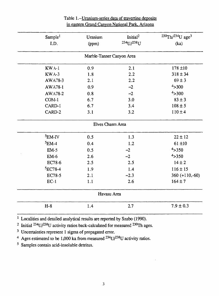
Table 1.-Uranium-series data of travertine depositsin eastern Grand Canvon National Park. Arizona
Sample1I.D.
KWA-1KWA-3AWA78-3
AWA78-1AWA78-2COM-1CARD-1CARD-2
Uranium(ppm) ^
Marble-Tanner Canyon
0.91.82.10.90.86.76.73.1
Initial2tu/238 u
Area
2.12.22.2~2~2
3.03.43.2
230Th/234u age3
(ka)
1781103181346913
4>3004>3008313
1081511014
Elves Chasm Area
5EM-IV5EM-4
EM-5EM-6EC78-6
5EC78-4EC78-5EC-1
0.50.4
1.31.2
0.5 ~22.6 ~22.51.92.11.1
2.51.4
-2.32.6
2211261110
4>3504>350
1412116115360(+110,-60)16417
Havasu Area
H-8 1.4 2.7 7.9 1 0.3
1 Localities and detailed analytical results are reported by Szabo (1990).2 Initial ^U/238!! activity ratios back-calculated for measured 230Th ages.3 Uncertainties represent 1 sigma of propagated error.4 Ages estimated to be 1,000 ka from measured 234u/238U activity ratios.5 Samples contain acid-insoluble detritus.

AGE RANGE
o MC-
H-
~8-30 ~ 55-85 ~1 00- 130 ~155-190 ~ 290-460
50 100 ?50 20cf1xAGE (ka)
>1000
«i
1300
5y^-^
1400
r MS
L-V-1500 ^1000
Fig. 1. Uranium-series dated travertine samples from Grand CanyonNational Park localities. Error bars shown represent propagated la errors. (MC=Marble Canyon, TC=Tanner Canyon, EC=Elves Chasm and H=Havasu area; after Szabo, 1990).

(Winograd and others, 1988, 1992; Ludwig and others, 1992). Our interpretation is that the observed 6l 8O variations reflect changes in mean annual surface temperature at the recharge areas of Ash Meadows ground water basin. The lighter 6 18O values indicate that lower surface temperatures occurred between about 50 and 115 ka and between 150 and 200 ka: heavy 6l8O values between about 120 and 135 ka indicate warmer climate during the last interglacial. The remarkable similarity of the DH-11 6 18O curve to the SPECMAP marine 6 18O record (r=0.85) indicates that it is recording global as well as regional paleotemperatures (Winograd and others 1992).
PALEO-WATER-TABLE ELEVATIONS
Vein calcites, in association with tufas, permit accurate dating of paleo-water table stands. Paleozoic carbonate rocks comprise a major regional aquifer system in east central Nevada (Winograd and Thordarson, 1975). The Spring Mountains and Sheep Range are the principal recharge areas, with modern discharge occurring along a spring line at the Ash Meadows basin in the Amargosa Desert (Fig. 2). Due to supersaturation of ground water with respect to calcite, all fractures in the carbonate aquifer at Ash Meadows and vicinity (Fig. 2) are coated with subaqueously precipitated vein calcite. The climate of the Great Basin area including Ash Meadows is presently arid to semiarid, but various types of evidence indicate the existence of past wetter-than-present conditions during late Quaternary time (Quade, 1986; Benson and Thompson, 1987; Van Devender and others, 1987).
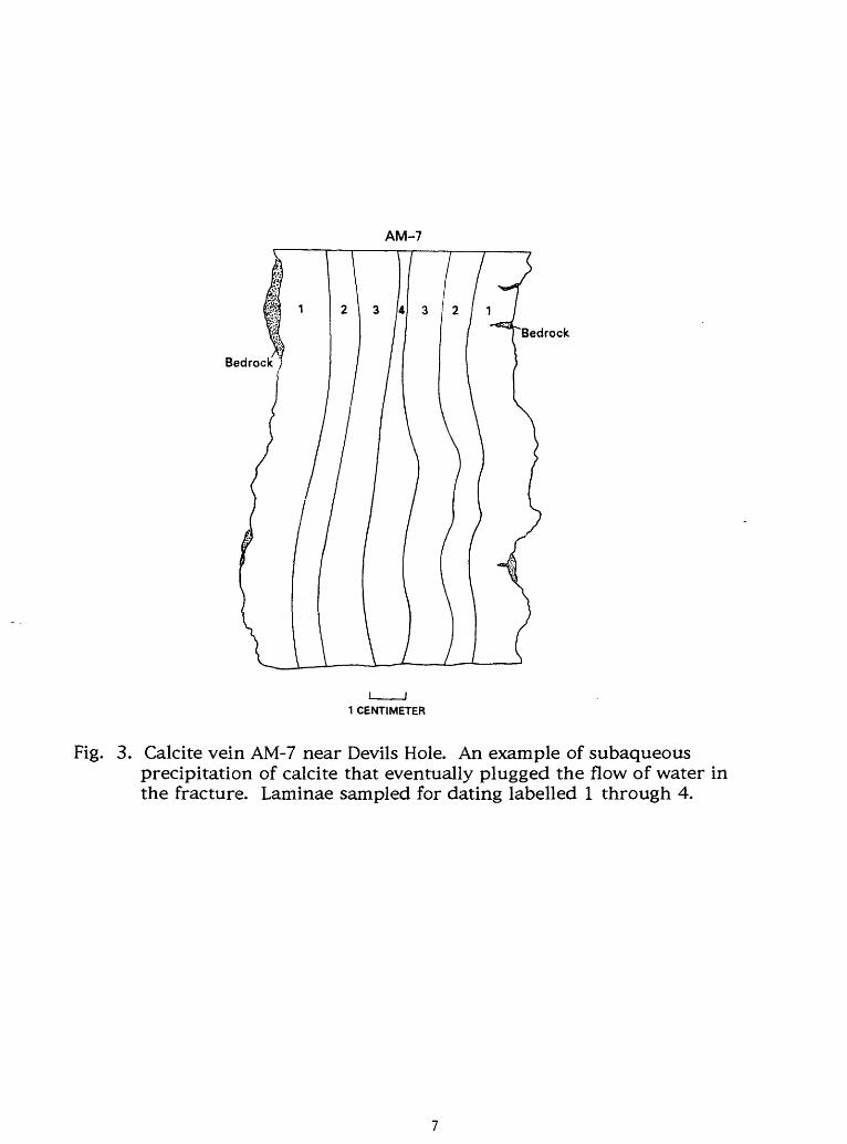
Because regional ground-water discharge was anticipated to have occurred above the modern level during periods of Pleistocene pluvial climates, Winograd and Doty (1980) surveyed the area of Ash Meadows for evidence of fossil spring deposits. They reported occurrences of spring-related vein calcite up to 50 m above the highest modern water-table elevation of 719 m recorded in Devils Hole (Fig. 2). Three calcite vein deposits (AM-7, DH-1 and AM-10; Fig. 2), respectively at elevations of 11, 19 and 26 m above modern water table in Devils Hole, were selected for dating. Samples from these dense calcite veins, which fill bedrock fractures, were cut parallel to laminations (Fig. 3), then dated by the alpha-spectrometric uranium-series method. The measured 23Qph/234U activity ratios are in or near secular equilibrium, thus yielding minimum age estimates only (Table 2). For these older vein samples, 234U ages were calculated from present day and initial 234U/238 U values. The initial 234jj/238u value of 2.70±0.02 used for the 234U age calculation was obtained from alpha-spectrometric results of dated Devils Hole veins DH-2 (Winograd and others, 1988), DH-11, and from analyzed ground water samples of Devils Hole Spring (Table 3). The approximate constancy of initial 234jj/238u (Table 3) is attributable to the large size of the Ash Meadows ground

116045'
LOCATION DIAGRAMBare ©
^Mounjain Yucca Mountain
Crater Flat
AM-10
Fairbanks Amargosa
r \
10 i
15I
20 KILOMETERS
Fig. 2. Index map of southern Great Basin. Localities discussed in textmarked by Xfs. The mark for calcite veins DH-1, -2 and -11 indicates the location of Devils Hole.
AM-7
Bedrock
Bedrock
1 CENTIMETER
Fig. 3. Calcite vein AM-7 near Devils Hole. An example of subaqueousprecipitation of calcite that eventually plugged the flow of water in the fracture. Laminae sampled for dating labelled 1 through 4.
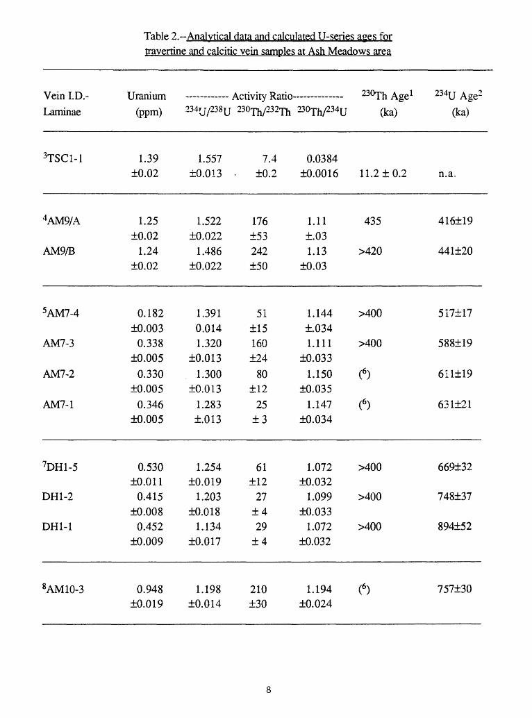
travertine and calcitic vein samoles at Ash Meadows area
Vein I.D.-Laminae
3TSC1-1
4AM9/A
AM9/B
5AM7-4
AM7-3
AM7-2
AM7-1
7DHl-5
DH1-2
DH1-1
8AM10-3
Uranium
(ppm)
1.39±0.02
1.25±0.02
1.24±0.02
0.182±0.003
0.338±0.005
0.330±0.005
0.346±0.005
0.530±0.011
0.415±0.008
0.452±0.009
0.948±0.019
_________ A f;tivity Rati _______ 230Th A$TP J
234TJ/238U 230^/232^ 230^/23^ (ka)
1.557
±0.013 -
1.522±0.022
1.486±0.022
1.3910.0141.320
±0.013
1.300±0.013
1.283±.013
1.254±0.019
1.203±0.018
1.134±0.017
1.198±0.014
7.4±0.2
176±53242±50
51±15160±24
80±12
25±3
61±12
27±429
±4
210±30
0.0384
±0.0016 11.2 ±0.2
1.11 435±.031.13 >420
±0.03
1.144 >400±.0341.111 >400
±0.0331.150 (6)
±0.0351.147 (6)
±0.034
1.072 >400±0.032
1.099 >400±0.033
1.072 >400±0.032
1.194 (6)±0.024
234U Age2
(ka)
n.a.
416±19
441±20
517±17
588±19
611119
631121
669±32
748±37
894±52
757±30

Table 2.--Analytical data and calculated U-series ages fortravertine and calcitic vein
9TW-A-
TW-A-2
0.121±0.004
0.115±0.004
0.999±0.022
1.020±0.025
samples at Ash Meadows area continued:
11+ 1
6±1
0.884 ( 10)±0.033
0.941 >250±0.037
>1,200
>1,200
1 230u ages were caicuiateci with half-lives of 230Th of 75,200 and 234U of 244,000 years, respectively; uncertainties represent 1 sigma propagated error.
2 234U ages were caculated using initial 234U/238U of 2.70±0.02.3 Travertine from Trout Spring Cave, Spring Mountains, Nevada4 Horizontal vein in Plio-Pleistocene lake beds at Ash Meadows.5 Vein deposit AM7 is 11 m above water-table elevation in Devils Hole (719 m), Ash Meadows.6 Excess ^OTh, age cannot be calculated.7 Vein deposit DH1 is 19m above water-table elevation in Devils Hole, Ash Meadows.8 Vein deposit AM 10 is 26m above water-table elevation in Devils Hole, Ash Meadows.9 Vein deposit in Travertine Wash, Amargosa Flat.10 Discordant ^^h age is disregarded, n.a. = not applicable

Table 3.--Initial ^U/^IJ activity ratios in Devils Holecalcitic veins and in samoles of sround water. Ash Meadows
Distance 230Th age(mm) 1 (ka)
Measured234U/238U
Calculated2Initial 234U/238U
DH-2 Vein3
2 61±6
6 64±2
20 85±3
25 95±3
42 121±4
50 151±5
55 163±7
63 150±7
70 196±9
90 216±12
93 248±16
113 249±17
2.415±0.035
2.445±0.030
2.312±0.029
2.264±0.026
2.163±0.027
2.079±0.024
2.060±0.024
1.996±0.035
1.997±0.022
1.994±0.022
1.917±0.023
1.859±0.025
2.68
2.73
2.67
2.66
2.64
2.66
2.68
2.53
2.74
2.74
2.85
2.74
10
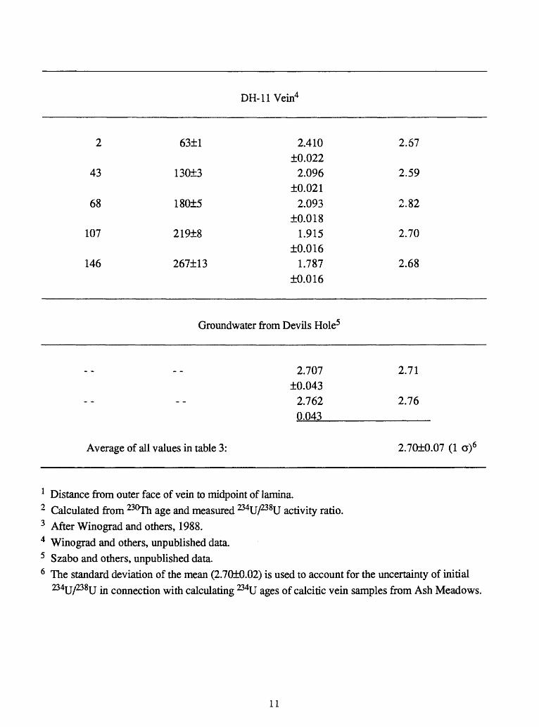
DH-11 Vein4
2 63±1
43 130±3
68 180±5
107 219±8
146 267±13
2.410±0.0222.096
±0.0212.093
±0.0181.915
±0.0161.787
±0.016
2.67
2.59
2.82
2.70
2.68
Groundwater from Devils Hole5
2.707 2.71 ±0.043
2.762 2.76 0.043___________
Average of all values in table 3: 2.70±0.07 (1 a)6
1 Distance from outer face of vein to midpoint of lamina.2 Calculated from 230Th age and measured 234U/238U activity ratio.3 After Winograd and others, 1988.4 Winograd and others, unpublished data.5 Szabo and others, unpublished data.6 The standard deviation of the mean (2.70+0.02) is used to account for the uncertainty of initial
234U/238U in connection with calculating 234U ages of calcitic vein samples from Ash Meadows.
11
water basin upgradient from the discharge area (Winograd and Thordarson, 1975), where local differences can be homogenized. That the calcite veins behaved as geochemically closed systems is indicated by Figure 4. Addition or subtraction of uranium or thorium isotopes from the vein calcite over the past 300 ka would have resulted in a large scatter of experimental data about the dashed line representing the radioactive decay of 234u/238jj with respect to time.
From the elevations of fossil vein deposits AM-7, DH-1 and AM-10 relative to modern water level in Devils Hole, and from preliminary age estimates of the youngest part of the veins (510, 660, and about 750 ka), Winograd and Szabo (1988) previously reported rates of water-table decline between 0.02 and 0.08 m/ka. Thus the Ash Meadows area apparently underwent progressive lowering of the water table during the last 760 ka.
Recent work by Szabo and others (1994) addresses the magnitude of water- table rise during past pluvial cycles superimposed on the slower regional decline of the water table during the Quaternary. Results from dating of speleothems sampled above present water level in a cave in Devils Hole, called Browns Room, indicate increased effective precipitation at Ash Meadows between about 20 and 120 kyr that maintained water-table elevation between +5 and +9 m above the modern level.
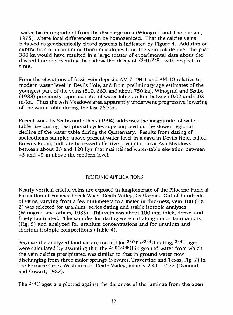
TECTONIC APPLICATIONS
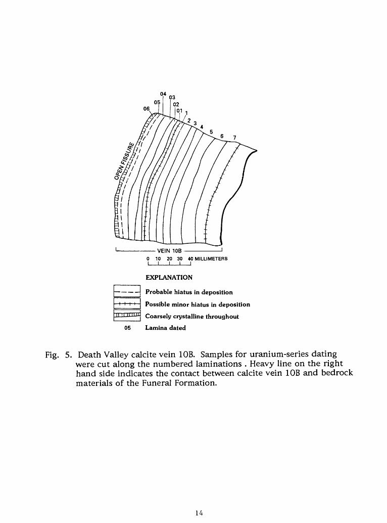
Nearly vertical calcite veins are exposed in fanglomerate of the Pliocene Funeral Formation at Furnace Creek Wash, Death Valley, California. Out of hundreds of veins, varying from a few millimeters to a meter in thickness, vein 10B (Fig. 2) was selected for uranium- series dating and stable isotopic analyses (Winograd and others, 1985). This vein was about 100 mm thick, dense, and finely laminated. The samples for dating were cut along major laminations (Fig. 5) and analyzed for uranium concentrations and for uranium and thorium isotopic compositions (Table 4).
Because the analyzed laminae are too old for 23°Th/234U dating, 234U ages were calculated by assuming that the 2 34jj/238u jn ground water from which the vein calcite precipitated was similar to that in ground water now discharging from three major springs (Nevares, Travertine and Texas, Fig. 2) in the Furnace Creek Wash area of Death Valley, namely 2.41 ± 0.22 (Osmond andCowart, 1982).
The 234U ages are plotted against the distances of the laminae from the open
12

0.2 0.4 0.6 0.8
230Th/234u ACTIVITY RATIO
10.0 12.0
Fig. 4. Variation of 234|j/238u and 23Or;h/234u with no initialDashed line shows the change in the nuclide activity ratios in Devils Hole calcite veins as age increases. (o=present day ground water samples, A=calcite vein DH-2 samples, v=calcite vein DH-11 samples).
13
VEIN 10B0 10 20 30 40 MILLIMETERSI I I I I
EXPLANATION
Probable hiatus in deposition
Possible minor hiatus in deposition
Coarsely crystalline throughout
Lamina dated
Fig. 5. Death Valley calcite vein 10B. Samples for uranium-series dating were cut along the numbered laminations . Heavy line on the right hand side indicates the contact between calcite vein 10B and bedrock materials of the Funeral Formation.
14
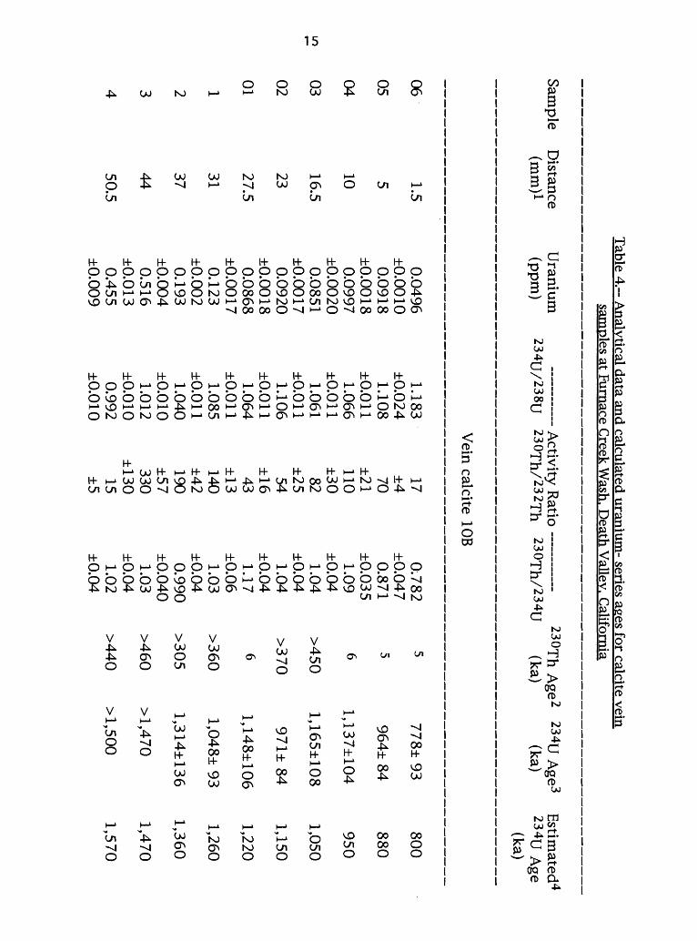
Table 4
. Analvtical data and calculated uranium
- series ages for calcite vein
LO
samples at Furnace
Sam
ple D
istance (m
m)1
Uranium
(ppm
)234T
J/238TJ
Creek W
ash, Death
Activity R
atio
230Th/232
Th
2< Vallev. C
alifornia
;OT
h/234L230fh A
ge2 234jj A
ge3 J
(ka) (ka)
Estim
ated4 234u A
ge(ka)
Vein calcite 10B
0605040302011234
1.5
51016.5
2327.5
31374450.5
0.0496±
0.00100.0918
±0.00180.0997
±0.00200.0851
±0.00170.0920
±0.00180.0868
±0.00170.123
±0.0020.193
±0.0040.516
±0.0130.455
±0.009
1.183±
0.0241.108
±0.0111.066
±0.0111.061
±0.0111.106
±0.0111.064
±0.0111.085
±0.0111.040
±0.0101.012
±0.0100.992
±0.010
17±
470±21110±
3082±2554±1643±13140±42190±57330
±13015±5
0.782±
0.0470.871
±0.0351.09
±0.041.04
±0.041.04
±0.041.17
±0.061.03
±0.040.990
±0.0401.03
±0.041.02
±0.04
556
>450
>370
6
>360
>305
>460
>440
778± 93
964± 84
1,137±104
1,165±108
971± 84
1,148±106
1,048± 93
1,314±136
>1,470
>1,500
800
880
950
1,050
1,150
1,220
1,260
1,360
1,470
1,570
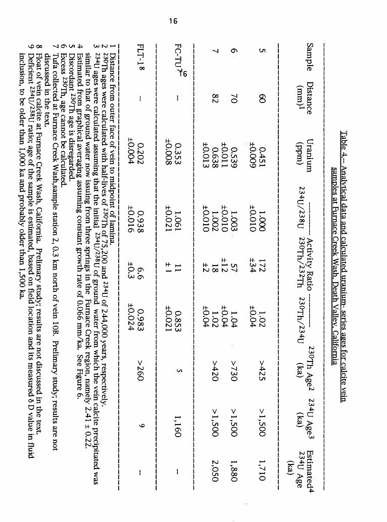
Table 4
. Analytical data and calculated uranium
- series ages for calcite vein sam
ples at Furnace Creek W
ash. Death V
alley. California
Sample
Distance
(mm
)1
5 60
6 70
7 82
toF
C-T
U^
FLT
-18
Uranium
(ppm
)
0.451±0.009
0.539±0.011
0.638±0.013
0.353±0.008
0.202±
0.004
23
4u
/23
8u
1.000±
0.010
1.003±
0.0101.002
±0.010
1.061±0.021
0.938±
0.016
Activity R
atio 230T
h/232
Th
172±
3457±
1218±211±
16.6±0.3
__
__
_
230Th A
ge2230T
h/2
34
u
(ka
)
1.02 >
425
±0.0
4
1.04 >
730±
0.041.02
>420
±0.04
0.853 5
±0.021
0.983 >
260±
0.024
234U A
ge3 E
stimated4
(ka) 234U
Age
(ka)
>1,500
1,710
>1,500
1,880
>1,500
2,050
1,160
9
1 D
istance from outer face of vein to m
idpoint of lamina.
2 23°T
h ages were calculated w
ith half-lives of 230Th of 75,200 and 234U
of 244,000 years, respectively.3
234U ages w
ere calculated assuming that the initial 234U
/238U of ground w
ater from w
hich the vein calcite precipitated was
similar to that of ground w
ater now issuing from
three springs in the Furnace C
reek region, namely 2.41 ± 0.22.
4 Estim
ated from graphical averaging assum
ing constant growth rate of 0.066 m
m/ka.
See Figure 6.5
Discordant 230T
h age is disregarded.6 Excess 230Th, age cannot be calculated.7 T
ufa collected at Furnace Creek W
ash,sample station 2, 0.3 km
north of vein 10B. Prelim
ary study; results are not discussed in the text.
8 Float of vein calcite at Furnace Creek W
ash, California.
Prelimary study; results are not discussed in the text.
9 Deficient 234U
/238U ratio; age of the sam
ple is estimated, based on field location and its m
easured 6 D value in fluid
inclusion, to be older than 1,000 ka and probably older than 1,500 ka.

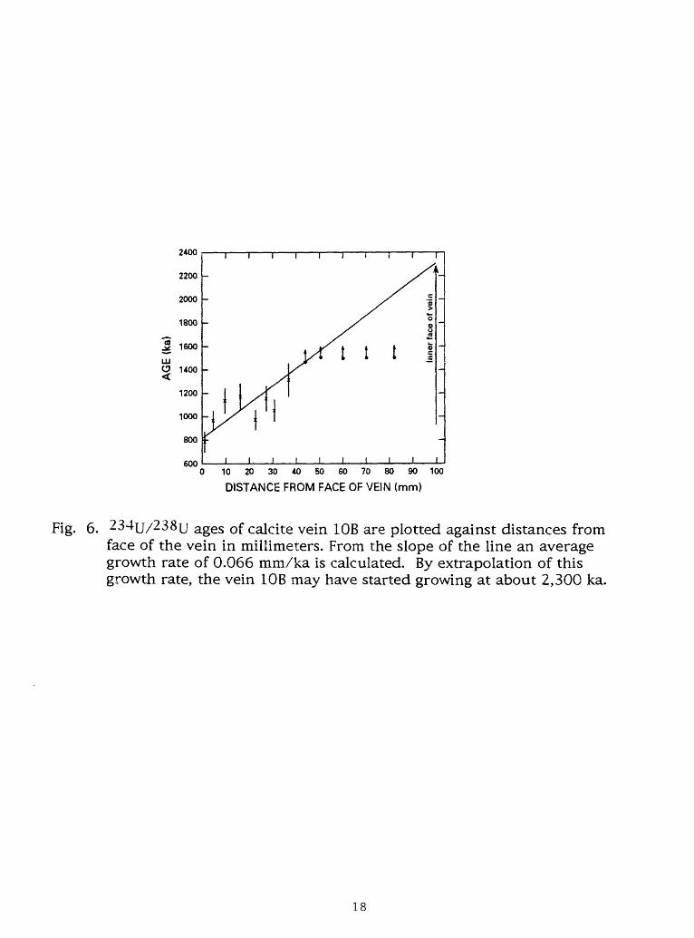
face of the vein on Figure 6. From the best fit line of the data, we estimate that the vein calcite was deposited at an average rate of 0.066 mm/ka between about 800 and 1,400 kyr. Extrapolation of this growth rate suggests that the vein may have started growing at about 2,300 ka (Fig. 6).
The maximum elevation of the calcite veins and associated tufa deposit near vein 10B is about 855 m. Winograd and Szabo (1988) computed average rates of vertical uplift in the range of 0.2 to 0.6 m/ka, utilizing sparse water-table altitude data available in 1986, and assuming that the displacement of the veins and tufa near vein 10B (Table 4) is due principally to Quaternary vertical tectonism. We noted (Winograd and Szabo, 1988, p. 150) that Carr (1984) utilizing other geologic data, computed an average uplift rate of 0.3 m/ka. Since publication of our paper, Winograd measured the water-table altitude in a test well 2.7 km east of vein 10B. This altitude (650 m) when used with the minimum age of vein 10B and the maximum altitude of the veins and tufa near 10B (855 m), yields an average uplift rate of 0.26 m/ka; this rate essentially matches that proposed by Carr.
Whereas the uranium concentration is nearly constant through time in DH-2 vein of Devils Hole (0.47±0.05 ppm; Winograd and others, 1988), the uranium concentration in vein 10B varies over a factor of ten, from about 0.050 and 0.64 ppm (Table 4). In Figure 7, the uranium concentrations were plotted against 234U age estimates assuming constant growth rate of of 0.066 mm/ka (last column in Table 4). The correlation coefficient of 0.92 indicates a statistically significant relationship between uranium concentration and time of deposition. The trend of decreasing concentrations of dissolved uranium with time indicates significant changes in the water-rock interaction processes during the time of the calcite vein precipitation (between about 800 and 2,100 kyr) in this tectonically active area.
The timing of tectonic activities (faulting or jointing) and of vadose water flow may also be estimated by dating of travertines deposited mostly above water table in fractures. All of these ages are calculated by assuming a closed system with respect to uranium and thorium, rapid rates of precipitation, a single generation of carbonate deposition, and that the carbonate precipitation occurred after the fracturing. However, no reliable methods exist to ascertain the validity of these assumptions: therefore, the calculated ages have to be considered minimum age estimates for the last activity of the fault or opening of joints.
Some of the previously discussed calcite veins filling nearly vertical fractures in Furnace Creek Wash, Death Valley (near vein 10B, Fig. 2) were displaced horizontally along a brecciated low-angle fault zone. Travertine filling in this
17
ill
2400
2200
2000
1800
1600
uoo
1200
1000
800
6000 10 20 30 40 50 60 70 80 90 100
DISTANCE FROM FACE OF VEIN (mm)
Fig. 6. 234u/238|j ages of calcite vein 10B are plotted against distances from face of the vein in millimeters. From the slope of the line an average growth rate of 0.066 mm/ka is calculated. By extrapolation of this growth rate, the vein 10B may have started growing at about 2,300 ka.
18

0.7
0.6
0.5
I °-4Q.
D 0.3
0.2
0.1
0.01000 2000
AGE (ka)
3000
Fig. 7. Plot of uranium concentrations in calcite vein 10B against 234{j/238u ages. The calculated correlation coefficient of 0.92 shows correlation between uranium concentration (ppm) and time of deposition (ka).
19

fault zone yielded a minimum age estimate of 132± 12 ka for the last significant movement (Szabo and O'Malley, 1985).
Szabo and Kyser (1985) and (1990) dated calcite veins that fill joints in drill cores of Tertiary volcanic rocks underlying Yucca Mountain, Nevada. The ages of calcite samples range from 26 to >400 ka. Stable isotope compositions of the samples suggest that the calcite veins precipitated predominantly from meteoric water descending through the volcanic section toward the water table.
Szabo and others (1981) reported uranium-series dates of possible spring- related calcite veins in fractures of Paleozoic carbonate rocks in the Mercury Valley area (Fig. 2). Some of their analytical data and calculated ages together with previously unpublished stable isotopic data on the veins (analyses by T. K. Kyser) are reported in Table 5. In three samples (30, 32 and 45) undisturbed fault-filling materials gave ages >700 ka. Sample 47, however, yielded a finite minimum age of about 100 ka for the latest opening along this fault.
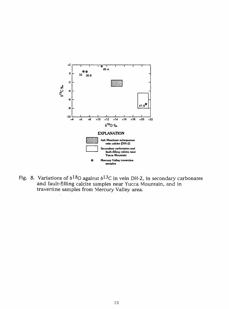
The existence of a 100 ka calcite vein apparently precipitated from ground water at this location seemed anomalous (Winograd and Doty, 1980, p. 61, 62) because the sample was collected at an elevation of 1140 m or about 420 m above the modern water table. If we were to accept a ground-water origin for this 100,000-year old vein, we would have to consider also the possibility of significantly elevated ground water levels during late Pleistocene pluvial times. On Figure 8, the field of 6 18O against 6 13C of a subaqueous calcite vein, DH-2 from Devils Hole (Winograd and others 1987, 1988) is depicted as a hatchured rectangle. The field of the same isotopes obtained for pedogenic calcretes, veins, and carbonate cements from Trench 14 on the east side of Yucca Mountain (Whelan and Stuckless, 1990) is shown by an open rectangle. The values of 618O and 6 13C of the 100-ka calcite vein 47 occur in the field of stable isotopic compositions of pedogenic carbonates (Fig. 8) indicating a pedogenic, rather than a ground water, origin for vein 47. In addition, the measured 2341J/238U activity ratios of 1.12 and 1.17 in vein 47 (Table 5) show that the vein cannot have been precipitated from the regional ground water, which has a 234u/238u of 3.08±0.12 (Osmond and Cowart, 1982), because more than 700 kyr would be required for 234y/238u in such a vein to decay to the measured value of about 1.17. From these considerations, we conclude that the 100-ka vein 47 has no relation to pluvial ground water level elevations. Also plotted on Fig. 8 are the 6 18O and 6 13 C values of the >700 ka veins 30, 32 and 45. These deposits have low 618O and high 6 13C values that are probably the result of their formation at high temperatures (T. K. Kyser, University of Saskatchewan, written commun., 1982).
20
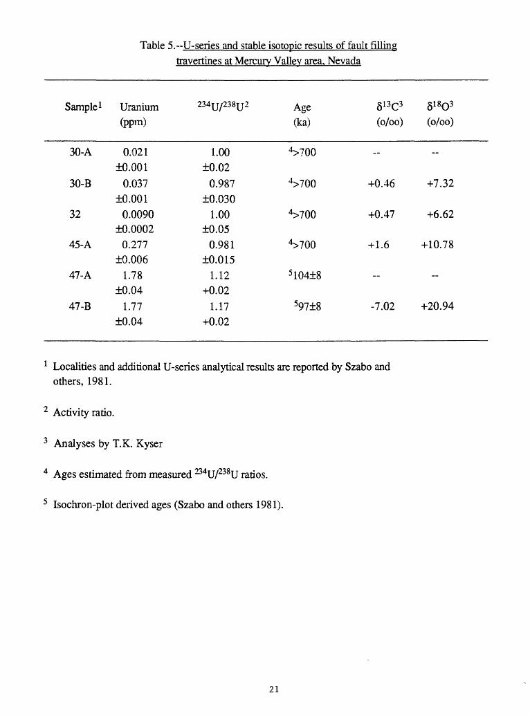
Table 5.-U-series and stable isotopic results of fault fillingtravertines at Mercury Vallev area. Nevada
Sample 1
30-A
30-B
32
45-A
47-A
47-B
Uranium
(ppm)
0.021±0.001
0.037±0.001
0.0090±0.0002
0.277±0.006
1.78±0.04
1.77±0.04
234U/238U 2
1.00±0.02
0.987±0.030
1.00±0.05
0.981±0.015
1.12+0.02
1.17+0.02
Age(ka)
4>700
4>700
4>700
4>700
5 104±8
597±8
6 13C3 61803
(o/oo) (o/oo)
__
+0.46 +7.32
+0.47 +6.62
+ 1.6 +10.78
__
-7.02 +20.94
1 Localities and additional U-seiies analytical results are reported by Szabo and others, 1981.
2 Activity ratio.
3 Analyses by T.K. Kyser
4 Ages estimated from measured 234U/238U ratios.
5 Isochron-plot derived ages (Szabo and others 1981).
21
+2
0
-2
O -4
1o-6
-8
-10
i I I45-A
32 30-B
47-B
I I I I____I____I____I____I+4+6+8 +10 +12 +14 +16 +18 +20 +22
5180%o
EXPLANATION
Ash Meadows subaqueous vein calcite (DH-2)
Secondary carbonates and fault-filling calcite near Yucca Mountain
® Mercury Valley travertine samples
Fig. 8. Variations of 6 1SO against 6 13 C in vein DH-2, in secondary carbonates and fault-filling calcite samples near Yucca Mountain, and in travertine samples from Mercury Valley area.
22

SUMMARY
Samples of travertine and calcite vein deposits from several localities within the southern Great Basin and from localities in the Grand Canyon area were analyzed using the uranium-series method. Dating results indicate the deposits accumulated during several wet intervals, ranging from about 15 to > 1,000 ka. The present climate in the southern Great Basin is arid to semiarid, but evidence indicates the existence of past wetter-than-present conditions during Quaternary time. Data from samples of calcite veins in Devils Hole, Nevada, indicate a warmer climate during the last interglacial bracketed by periods of lower surface temperatures. Dating results from calcite layers above the present water level indicate increased effective precipitation in the vicinity between about 20 and 120 kyr.
Extrapolation of the growth rate, based on uranium-series dating for a calcite vein located in Death Valley, California, suggest the vein may have accumulated uninterrupted between about 800 and 2,300 kyr. Data from water-table altitudes measured in the vicinity yield an average rate of tectonic uplift of 0.26 m/ka. This value compares with those of previous geologic studies (0.3 m/ka).
Measurements of stable isotopic compositions of dated fracture fillings and determination of isotopic composition of uranium in associated regional ground water may be useful for assessing the origin of erratic carbonate deposits. In the Mercury Valley area, one sample yielded a minimum age of about 100 ka. A ground water origin for this sample would indicate significantly elevated ground water levels during the late Pleistocene. This possibility is unlikely, because 618O and 6 13C values of the samples when compared with data from Devils Hole and Trench 14 near Yucca Mountain fall in the range of stable isotopic composition of pedogenic carbonates.
Most travertines, in general, and subaqueous, precipitated calcite veins of ground water origin, in particular, are reliable materials for uranium-series dating. Dating such travertine samples has the potential of yielding significant information regarding local and regional paleoclimatic changes, location of paleo-ground water discharge areas, paleo-water table altitudes and the timing of faulting. Utilization of the uranium-series method for dating ground water elevations during pluvial times is especially important for the evaluation of suitability of the unsaturated zone of Yucca Mountain for isolation of high-level radioactive waste.
23

ACKNOWLEDGEMENTS
We thank K. Ludwig, J. Rosholt and V. Glanzman for their valuable review comments. This work was supported in part by the Global Change and Climate History Program of the U.S. Geological Survey.
REFERENCES CITED
Benson, K. V. and Thompson, R. S. (1987). The physical records of lakes in the Great Basin. In: Ruddiman, W. F. and Write, H. E. Jr., (eds.), North America and Adjacent Oceans During the Last Deglaciation, pp. 241-260. The Geology of North America, v. K-3, The Geological Society of America, Boulder, Colorado.
Carr, W. J. (1984). Regional structural setting of Yucca Mountain, southwestern Nevada, and late Cenozoic rates of tectonic activity in part of the southwestern Great Basin, Nevada and California. U.S. Geological Survey Open-File Report 84-854, 109 pp.
Gascoyne, M. and Schwacz, H. P. (1982). Carbonate and sulphate precipitates. In: Ivanovich, M. and Harmon, R. S., (eds.), Uranium Series Disequilibrium: Application to Environmental Problems, pp.268-301, Oxford University Press, New York.
Ludwig, K. R., Simmons, K. R., Szabo, B. J., Winograd, I. J., Landwehr, J. M., Riggs, A. C, and Hoffman, R. J. (1992). Mass-spectrometric 230xh-234u- 238U dating of the Devils Hole calcite vein. Science, v. 258, p. 284-287.
Osmond, J. K. and Cowart, J. B. (1982). Groundwater. In: Ivanovich, M. and Harmon, R. S., (eds.), Uranium Series Disequilibrium: Application to Environmental Problems, pp. 203-245, Oxford University Press, New York.
Quade, J. (1986). Late Quaternary environmental changes in the upper Las Vegas Valley, Nevada. Quaternary Research, v. 26, p. 340-357.
Stewart, B. D., McKlueen, J. W., and Olinski, R. L (1988). Determination of uranium and radium concentrations in the waters of the Grand Canyon by alpha spectrometry. Journal of Radioanalytical and Nuclear Chemistry, v. 123, p. 121-132.
Szabo, B. J. (1990). Ages of travertine deposits in eastern Grand Canyon National Park, Arizona. Quaternary Research, v. 34, p. 24-32.
Szabo, B. J. and Kyser, T. K. (1985). Uranium, thorium isotopic analysesuranium-series ages of calcite and opal, and stable isotopic compositions of calcite from drill cores UE25a-l, USW G-2, and USW G-3/GU-3, Yucca
Mountain, Nevada. U. S. Geological Survey Open-File Report 85-224, 25 pp.
Szabo, B. J. and O'Malley, P. A. (1985). Uranium-series dating of secondary carbonate and silica precipitates relating to fault movements in the Nevada Test Site region and of caliche and travertine samples from the Amargosa Desert. U. S. Geological Survey Open-File Report 85-47, 13 pp.
24
Szabo, B. J. and Kyser, T. K. (1990). Ages and stable-isotope compositions of secondary calcite and opal in drill cores from Tertiary volcanic rocks of the Yucca Mountain area, Nevada. Geological Society America Bulletin, v. 102, p. 1714-1719.
Szabo, B. J., Carr, W. J., and Gottschall, W. C. (1981). Uranium-thorium dating of Quaternary carbonate accumulations in the Nevada Test Site region, southern Nevada. U. S. Geological Survey Open-File Report 81-119, 35 pp.
Szabo, B. J., Kolesar, P.T., Riggs, A.C., Winograd, I.J., and Ludwig, K.R. (1994). Paleoclimatic inferences from a 120,000-yr calcite record of water-table fluctuation in Browns Room of Devils Hole, Nevada. Quaternary Research, v. 41, p. 59-69.
Van Devender, T. R., Thompson, R. S., and Betancourt, J. L (1987). Vegetation history of the deserts of southwestern North America: The nature and timing of the Lake Wisconsin-Holocene transition. In Ruddiman W. F. and Write, H. E. Jr. (eds.), North America and Adjacent Oceans During the Last Deglaciation, pp. 323-352. The Geology of North America, v. K-3, The Geological Society of America, Boulder, Colorado.
Whelan, J. F. and Stuckless, J. S. (1990). Reconnaissance 6 13C and 6 180 datafrom Trench 14, Busted Butte, and drill hole G-4, Yucca Mountain, Nevada Test Site. In: High level radioactive waste management, pp. 930-933. American Nuclear Society, Inc., La Grange Park, v.2.
Winograd, IJ. and Thordarson (1975). Hydrogeologic and hydrochemical framework, south-central Great Basin, Nevada-California, with special reference to the Nevada Test Site. U. S. Geological Survey, Professional Paper712-C, 126pp.
Winograd, I. J. and Doty, G. C. 1980. Paleohydrology of the southern Great Basin with special reference to water table fluctuations beneath the Nevada Test Site during the late (?) Pleistocene. U. S. Geological Survey Open- File Report 80-569, 91pp.
Winograd, I. J. and Szabo, B. J. (1988). Water-table decline in the south- central Great Basin during the Quaternary: Implications for toxic waste disposal potential. In: Carr M. D. and Yount, J. C. (eds.), Nuclear Waste Disposal Site at Yucca Mountain, Southern Nevada. U. S. Geological Survey Bulletin 1790, p. 147-152.
Winograd, I. J., Szabo, B. J., Coplen, T. B., Riggs, A.C., and Kolesar, P.T. (1985). Two-million-year record of deuterium depletion in Great Basin groundwaters. Science v. 227, p. 519-522.
Winograd, I. J., Szabo, B. J., Coplen, T. B., and Riggs, A. C. (1987). Continuous 300,000-year record of oxygen-18 and carbon-13 variations in Great Basin groundwater. Geological Society America Abstract with Programs, v. 19, p. 893.
Winograd, I. J., Szabo, B. J., Coplen, T. B., and Riggs, A. C. (1988). A 250,000 year climatic record from Great Basin vein calcite: Implications for Milankovitch theory. Science v. 242, p. 1275-1280.
25

Winograd, I. J., Coplen, T. B., Landwehr, J. M., Riggs, A. C. Ludwig, K. R., Szabo, B. J., Kolesar, P. T., and Revesz, K. M. (1992). Continuous 500,000-year climate record from vein calcite in Devils Hole, Nevada. Science v. 258, p. 255-260.
26