Paleoclimatic Cycles, Sea Level History and Sequence ...
8
*Corresponding author Email: [email protected] PRINT ISSN 1119-8362 ELECTRONIC ISSN 1119-8362 J. Appl. Sci. Environ. Manage. Vol. 23 (2) 241–248 February 2019 Full-text Available Online at https://www.ajol.info/index.php/jasem http://ww.bioline.org.br/ja Paleoclimatic Cycles, Sea Level History and Sequence Stratigraphic Elements in Eocene–Oligocene Sediments of BIMOL-1 Well Northern Niger Delta Basin, Nigeria * 1 OSOKPOR, J; 2 EKWERE, UJ; 3 OTELE, A * 1 Department of Earth Sciences, Federal University of Petroleum Resources, PMB 1221, Effurun, Delta State, Nigeria. 2 Department of Geology, University of Benin, PMB. 1154, Benin City, Edo State, Nigeria. ***Department of Petroleum Engineering and Geoscience Technology, Federal Polytechnic, Ekowe, Bayelsa State, Nigeria. *Corresponding author Email: [email protected] ABSTRACT: Lithofacies succession and palynomorph data trends in BIMOL-1 well in the north-western Niger Delta Basin have been investigated in order to unravel paleoclimatic influence on paleo-sealevel change and facies evolution. Eight lithologic cycles composed of sand and shale were identified. Miospore speciation revealed forty two miospore form species and ten dinoflagellate cyst species. Miospore and dinocyst trends revealed six climate driven sea level cycles that influenced sedimentation and facies distribution and characteristics. Miospore age determination of the succession revealed L-Eocene to L-Oligocene age range. Nine wet and eight dry climate driven transgressive and regressive events were identified, corresponding to sea level rise and to sea level fall correspondingly. Dry climate occasioned continental progradation that generated thick sand intervals, while wet climate triggered sea level rise, generating thinner sand bodies as transgressive sand reservoirs. Seven high stands (HSTs), eight transgressive (TSTs) and eight lowstand (LSTs) systems tracts, distributed within nine sequences were identified. Candidate MFSs, the 50.0 Ma, 48.9 Ma, 46.1 Ma, 43.2 Ma, 41.0 Ma, 34.0 Ma MFSs were identified. Candidate SBs identified include the 50.7 Ma, 48.4 Ma, 47.2 Ma, 44.4 Ma, 42.7 Ma, 40.1 Ma and 32.4 Ma SBs. Early Rupelian sequence boundaries were identified. Erosion/non-deposition of the Priabonian and parts of the Bartonian stage were revealed that inferred erosion/non-deposition of about 7 Ma of sediments in the well area. A synthesis of results of the evaluated proxies revealed that Paleoclimate-driven sea level and paleovegetation trends acted as key facies generators in the well area. DOI: https://dx.doi.org/10.4314/jasem.v23i2.7 Copyright: Copyright © 2019 Oguntolu et al. This is an open access article distributed under the Creative Commons Attribution License (CCL), which permits unrestricted use, distribution, and reproduction in any medium, provided the original work is properly cited. Dates: Received: 15 August 2018; Revised: 01 January 2019; Accepted 11 January 2019 Keywords: Paleoclimateic cycles, climate driven sea level, Niger Delta, climatic index Ancient sedimentary successions host a variety of records which may be important in unravelling past sea level and climatic fluctuations. Eocene-Oligocene sediments of the Niger Delta Basin are known to register varied sea level regimes reflected in the cyclic lithofacies pattern of the formational units (Reijers, 2011). The abundance and presence of palynotaxa preserved in sediments has been used as paleoclimatic and paleocenographic proxies for many decades (Jan du Chene and Adediran, 1984; Gregory and Hart, 1992; Lucas, 1992; Elsik, and Yancey, 2000; Adeonipekun, et al., 2012) and the influence of climate on paleovegetation cyclicity and sea level change is well documented (Van Der Hammen, 1957, 1961; Rull and Poumot, 1997; Rull, 2000). Studies have shown that paleoclimatic trends and fluctuations can be revealed by biosignals stored in sedimentary successions. The study of palynotaxa provides beyond age determination, fundamental contributions of our understanding of ancient climatic regimes. The biogeography and diversity of palynotaxa through geologic time varied depending on latitudinal zonation as well as climatic dynamics and variability (McIntyre and Bè, 1967; Findlay and Giraudeau, 2000; Boecked and Baumann, 2008). Changing climate as experienced in the present is observed to drive vegetation trends and global sea level change and patterns. The imprint of this process generates various sedimentary signatures registered as facies depending on the location where such process operates. Tertiary sediments of the Niger Delta Basin display various lithofacies components distributed within different lithostratigraphic units (Short and Stauble, 1967; Avbovbo, 1978, etc.), known to be products of oscillating sea level regimes through geologic time (Reijers, 2011). Several studies on the palynology, sedimentology, paleodepositional environment and sequence stratigraphy etc., on the Niger Delta have been carried out to contribute to the knowledge base of the geology and history of the Delta, but few have been directed towards paleoclimatic and paleooceanographic factors that can be related to sequence stratigraphic framework. In this study, we seek to use biosignals to unearth paleoclimatic cycles
Transcript of Paleoclimatic Cycles, Sea Level History and Sequence ...

*Corresponding author Email: [email protected]
PRINT ISSN 1119-8362
ELECTRONIC ISSN 1119-8362
J. Appl. Sci. Environ. Manage.
Vol. 23 (2) 241–248 February 2019
Full-text Available Online at
https://www.ajol.info/index.php/jasem
http://ww.bioline.org.br/ja
Paleoclimatic Cycles, Sea Level History and Sequence Stratigraphic Elements in
Eocene–Oligocene Sediments of BIMOL-1 Well Northern Niger Delta Basin, Nigeria
*1OSOKPOR, J; 2EKWERE, UJ; 3OTELE, A
*1Department of Earth Sciences, Federal University of Petroleum Resources, PMB 1221, Effurun,
Delta State, Nigeria. 2Department of Geology, University of Benin, PMB. 1154, Benin City, Edo State, Nigeria.
***Department of Petroleum Engineering and Geoscience Technology, Federal Polytechnic, Ekowe, Bayelsa State, Nigeria.
*Corresponding author Email: [email protected]
ABSTRACT: Lithofacies succession and palynomorph data trends in BIMOL-1 well in the north-western Niger Delta
Basin have been investigated in order to unravel paleoclimatic influence on paleo-sealevel change and facies evolution. Eight lithologic cycles composed of sand and shale were identified. Miospore speciation revealed forty two miospore form
species and ten dinoflagellate cyst species. Miospore and dinocyst trends revealed six climate driven sea level cycles that
influenced sedimentation and facies distribution and characteristics. Miospore age determination of the succession revealed L-Eocene to L-Oligocene age range. Nine wet and eight dry climate driven transgressive and regressive events
were identified, corresponding to sea level rise and to sea level fall correspondingly. Dry climate occasioned continental
progradation that generated thick sand intervals, while wet climate triggered sea level rise, generating thinner sand bodies as transgressive sand reservoirs. Seven high stands (HSTs), eight transgressive (TSTs) and eight lowstand (LSTs) systems
tracts, distributed within nine sequences were identified. Candidate MFSs, the 50.0 Ma, 48.9 Ma, 46.1 Ma, 43.2 Ma, 41.0
Ma, 34.0 Ma MFSs were identified. Candidate SBs identified include the 50.7 Ma, 48.4 Ma, 47.2 Ma, 44.4 Ma, 42.7 Ma,
40.1 Ma and 32.4 Ma SBs. Early Rupelian sequence boundaries were identified. Erosion/non-deposition of the Priabonian
and parts of the Bartonian stage were revealed that inferred erosion/non-deposition of about 7 Ma of sediments in the well
area. A synthesis of results of the evaluated proxies revealed that Paleoclimate-driven sea level and paleovegetation trends
acted as key facies generators in the well area.
DOI: https://dx.doi.org/10.4314/jasem.v23i2.7 Copyright: Copyright © 2019 Oguntolu et al. This is an open access article distributed under the Creative
Commons Attribution License (CCL), which permits unrestricted use, distribution, and reproduction in any
medium, provided the original work is properly cited.
Dates: Received: 15 August 2018; Revised: 01 January 2019; Accepted 11 January 2019
Keywords: Paleoclimateic cycles, climate driven sea level, Niger Delta, climatic index
Ancient sedimentary successions host a variety of
records which may be important in unravelling past sea
level and climatic fluctuations. Eocene-Oligocene
sediments of the Niger Delta Basin are known to
register varied sea level regimes reflected in the cyclic
lithofacies pattern of the formational units (Reijers,
2011). The abundance and presence of palynotaxa
preserved in sediments has been used as paleoclimatic
and paleocenographic proxies for many decades (Jan
du Chene and Adediran, 1984; Gregory and Hart,
1992; Lucas, 1992; Elsik, and Yancey, 2000;
Adeonipekun, et al., 2012) and the influence of climate
on paleovegetation cyclicity and sea level change is
well documented (Van Der Hammen, 1957, 1961; Rull
and Poumot, 1997; Rull, 2000). Studies have shown
that paleoclimatic trends and fluctuations can be
revealed by biosignals stored in sedimentary
successions. The study of palynotaxa provides beyond
age determination, fundamental contributions of our
understanding of ancient climatic regimes. The
biogeography and diversity of palynotaxa through
geologic time varied depending on latitudinal zonation
as well as climatic dynamics and variability (McIntyre
and Bè, 1967; Findlay and Giraudeau, 2000; Boecked
and Baumann, 2008). Changing climate as
experienced in the present is observed to drive
vegetation trends and global sea level change and
patterns. The imprint of this process generates various
sedimentary signatures registered as facies depending
on the location where such process operates. Tertiary
sediments of the Niger Delta Basin display various
lithofacies components distributed within different
lithostratigraphic units (Short and Stauble, 1967;
Avbovbo, 1978, etc.), known to be products of
oscillating sea level regimes through geologic time
(Reijers, 2011). Several studies on the palynology,
sedimentology, paleodepositional environment and
sequence stratigraphy etc., on the Niger Delta have
been carried out to contribute to the knowledge base of
the geology and history of the Delta, but few have been
directed towards paleoclimatic and
paleooceanographic factors that can be related to
sequence stratigraphic framework. In this study, we
seek to use biosignals to unearth paleoclimatic cycles

Paleoclimatic Cycles, Sea Level History and Sequence….. 242
OSOKPOR, J; EKWERE, UJ; OTELE, A
locked in Eocene-Oligocene sediments of the Niger
Delta accessed through well cutting samples retrieved
from BIMOL-1 well in the northern Niger Delta Basin.
This study is aimed at investigating the paleoclimatic
cycles, sea level history and sequence stratigraphic
elements in Eocene – Oligocene sediments of BIMOL-
1 well northern Niger Delta basin, Nigeria. It is
envisaged that the cycles can be related to and used to
distinguish sedimentary packages that would reflect
systems tracts. In the Niger Delta sedimentary pile,
individual sea-level cycles are reflected in the various
sedimentary sequences and interferences of cycles
with different periods result in megasequences that are
chronostratigraphically confined and
sedimentologically characterised (Reijers, 2011).
Fig. 1: Generalized map of the Niger Delta showing main sedimentary environments (Allen, 1965; Whiteman, 1982)
Geological Setting of the Niger Delta Basin: The Niger
Delta Basin (Fig. 1) stands as one of the most prolific
hydrocarbon provinces in the African continent. With
a clastic wedge of just over 10 km thick, (Fig. 2), a
very high concentration of petroleum per unit volume
of rock is key note. known estimates of the ultimate
recoverable hydrocarbons from the Niger Delta
province range from 35 x 109 BBL of oil and 120 x
1012 SCF of gas (Ekweozor and Daukoru, 1994) to 66
x109 BBL of oil equivalent (BOE; Saugy and Eyer
2003). For many decades, exploration and production
has been concentrated mostly on land or in shallow
water, although since 1996 licensing rounds, major
deep-water discoveries, of the order of 109 BOE, have
been made (Agbami, Bonga, Bonga SW, Chota, Erha,
Usan, Ukot, Zafiro, Ikija, Etan and Bobo). The
sedimentary pile of the Niger Delta Basin has built out
over the African Atlantic continental margin and
adjacent oceanic crust since Eocene times (Evamy et
al., 1978). The sedimentary pile of the basin is
subdivided into a three-fold age diachronous
stratigraphic subdivision, into the marine Akata,
shallow marine Agbada and delta plain Benin
formations, which reflects the distinguishing
sedimentary environments of a regressive
megasequence (Short and Stauble, 1967; Doust and
Omatsola 1989; Morgan 2003).
Fig. 2: Schematic subsurface cross section showing the main
stratigraphic units of the Niger Delta Basin (after Ekweozor and
Okoye, 1980)
The Akata Formation which consists of parallel-
laminated mud has formed in deep water and, basin-
floor, pro-delta setting. Generally the Akata Formation
is viewed as the main source sediments for
hydrocarbons in the Niger Delta. It is 3–4 km thick and
overpressured (Short and Stauble, 1967; Doust and
Omatsola 1989; Haack et al., 2000). The Agbada
Formation consists of mixed clastic sediment, and is
about 3 km thick or more. The Agbada Formation was
formed in a paralic environment. Sediments of the
Agbada Formation act as the main reservoir rocks for
hydrocarbons generated in the basin. Capping the delta
is the Benin Formation which is largely continental
and fluvial in origin and consists of mainly sands.
MATERIALS AND METHODS Sampling: A total of fifty non-composited ditch
cuttings of sand and shale from a near-surface depth of
486 – 3216 m of the BIMOL-1 well located in the
western reaches of the north-western area of the Niger
Delta Basin (Fig. 1), were subjected to whole rock
visual grain textural analyses using stereomicroscopic
description to determine gross grain characteristic
(mineralogy, morphology, sorting, presence of
accessory materials, size distribution, and colour). The
well under study belongs by Shell Petroleum
Development Company (SPDC), but coded BIMOL-
1well in this study for confidentiality reasons. For
lithofacies description, a sampling range of 18 – 78 m
(av. = 56.5 m) for the upper section of the well (depth
range of 486 – 648 m), a sampling range of 18 – 108
m (av. = 66.71 m) for the mid-section (depth range of

Paleoclimatic Cycles, Sea Level History and Sequence….. 243
OSOKPOR, J; EKWERE, UJ; OTELE, A
828 – 1674 m) and a sampling range of 18 – 84 m with
an average of 52.50 m for the lower section (1782 –
3216 m) of the well was achieved, with a general
sampling range of 48.82 m for the well.
Palynological sample Preparation and Analysis: Thirty five (35) samples from the well section were
subjected to series of acid treatment for palynological
slide and analysis in accordance with techniques
described by Traverse (1988), while age determination
is based on earlier works by Muller (1959), Gemeraad
(1968), Adegoke (1969), Legoux (1978), and Sowumi
(1981b).
RESULTS AND DISCURSION Lithostratigraphy: Whole rock lithologic sample
description revealed eight distinct lithologic
units/successions in the well section as detailed below
(Fig. 3):
Unit 1 (3216 – 2970 m): This unit is composed of
246m thick black fossiliferous fissile shale and forms
the basal unit of the succession.
Unit 2 (2970 – 2856 m): This unit is composed of
114m thick subangular to subrounded coarse grained
sand, and unconformably overlies Unit 1.
Unit 3 (2856 – 2574 m): This sequence is composed of
about 282m of black carbonaceous fossiliferous shale.
Unit 4 (2574 – 2484 m): This interval is composed of
subrounded – rounded medium to coarse grained sand,
sandwiched between thick shale of unit 3 below and
unit 5 above.
Unit 5 (2484 – 1674 m): This unit is composed of
800m of black fossiliferous fissile shale. This unit
occur as the thickest unit in the well section.
Unit 6 (1674 – 1404 m): This interval is composed of
730m thick subangular – rounded medium to coarse
grained sand unconformably overlying shale of unit 5.
Unit 7 (1404 – 648 m): This unit is characterized by
756m of shale and sand interbeds. The shale interbeds
are fossiliferous and displays medium the dark grey
colour. The sand interbeds are characteristically
composed of subangular – rounded very fine to
medium grained sand.
Unit 8 (648 – 486 m): this unit caps the well section
and is also composed of sand and shale interbeds. It is
distinguished as a different unit based on the
morphological characteristics of the sand components
which displays subrounded to well-rounded fine to
medium grains and light to medium grey shale
interbeds.
Fig. 3: Lithologic of BIMOL-1 well showing the two main lithologies, sand and shale, in the sections.
Quantitative Distribution of Palynological
Constituents: The palynological constituents
recovered from the well were initially classified
according to their biological origin as continental and
marine forms and further sub-classified into Miospore,
fungi which together constitute the allochthonous
forms and dinocyst (Fig. 5) which makes up the
authochthonous fraction. Quantitative miospore
counts in the well ranged from thirty seven (37) to one
thousand four and sixty nine (1469), while
dinoflagellate cyst species count ranged from one (i)
to forty nine (49) at various depth intervals and
complete absence in some depth intervals.
Quantitative depth distribution of the various form
species are presented in Table 1. A total of forty two
(42) miospore species and ten (10) dinoflagellate cyst
species were identified in this study.

Paleoclimatic Cycles, Sea Level History and Sequence….. 244
OSOKPOR, J; EKWERE, UJ; OTELE, A
Table 1: Quantitative depth distribution of miospores and
dinocysts from BIMOL-1 well
S/N Depth
(m)
Pollen Spore Total
Miospore
Dinocyst
1 486 100 16 116 0
2 522 1434 35 1469 0 3 600 196 16 212 0
4 630 440 13 453 0
5 648 347 44 391 1 6 828 77 15 92 2
7 864 160 16 176 7
8 954 200 55 255 1 9 1062 163 08 171 0
10 1098 266 54 320 3
11 1116 241 88 329 0
12 1170 281 120 401 0
13 1224 281 180 461 1
14 1278 320 105 425 3
15 1314 346 116 462 1
16 1368 333 96 429 3
17 1404 292 36 328 1 18 1476 330 120 450 5
19 1512 41 02 43 0
20 1620 345 126 471 5 21 1674 360 53 413 1
22 1782 281 50 331 27 23 1836 32 05 37 8
24 1854 41 12 53 3
25 1890 59 01 60 2 26 1944 50 23 73 0
27 1998 370 6 435 4
28 2034 59 20 79 5 29 2106 45 02 47 49
30 2142 100 18 118 9
31 2214 72 02 74 22
32 2250 47 10 57 0
33 2322 54 02 56 2
34 2376 137 61 198 3
35 2457 113 12 125 39
36 2484 96 53 149 3
37 2538 65 05 70 6
38 2574 33 23 56 0
39 2610 47 03 50 5
40 2664 82 36 118 5 41 2700 110 12 122 2
42 2754 38 22 60 0
43 2808 467 39 506 9 44 2856 353 85 438 1
45 2916 231 38 269 3
46 2970 116 14 130 0 47 3024 113 03 116 0
48 3078 100 37 137 2
49 3132 174 03 177 0
50 3216 111 44 155 0
Sea level history, Paleoclimate and Climatic cycle: The integration of sedimentological and palynological
results from the well enabled valid inferences to be
made regarding the age of the sediments, changes in
sea level through time and paleoclimatic regime. From
graphical analysis of miospore and dinocyst
abundance (Fig. 4), inferences concerning sea level
history, paleoclimatic changes and cycles were made.
This analysis revealed a climate driven cyclic sea level
pattern that influenced sedimentation and facies
distribution and characteristics.
Sea Level History And Paleoclimatic Changes: Seal
level history which is the record of the rise and fall of
global sea level above and below its mean datum in
past geologic times and driven by paleoclimatic
indices which refers to past climatic conditions that
prevailed in a given region is defined in this work.
The importance of this record is seen as a rise in sea
level is marked by transgression of the sea, during
which a landward shoreline shift is recorded and vice
versa, thus important in erecting sequence
stratigraphic framework for sedimentary columns.
Clues about sea level history and paleoclimate in the
well area have been obtained from miospore and
dinocysts abundance as proxy indicators, such that a
climate driven rise in sea level is marked by wet
climatic conditions leading to lush vegetation and high
preservation of forms, while the reverse is obtained for
seal level fall.
The result of the graphical analysis of the plot of
miospore and dinocysts quantitative signatures with
depth (Fig. 4) reveals changes in the paleo sea level
and paleoclimate in the well section in which sea level
rise alternates with seal level fall at various depths,
revealing a cyclic pattern. In this signature, a rise and
fall in sea level corresponds to wet and dry climatic
conditions respectively (Table 2, Fig. 7).
Fig. 4: Graphical depth plots of miospore and dinoflagellate cysts
in BIMOL-1 well
Paleoclimatic Cycles, Sea Level History and Sequence….. 245
OSOKPOR, J; EKWERE, UJ; OTELE, A
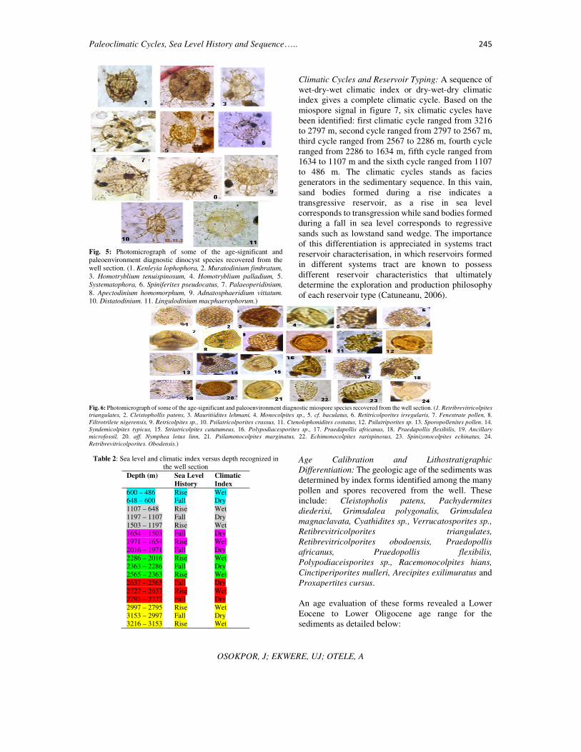
Fig. 5: Photomicrograph of some of the age-significant and paleoenvironment diagnostic dinocyst species recovered from the
well section. (1. Kenleyia lophophora, 2. Muratodinium fimbratum,
3. Homotryblium tenuispinosum, 4. Homotryblium palladium, 5.
Systematophora, 6. Spiniferites pseudocatus, 7. Palaeoperidinium,
8. Apectodinium homomorphum, 9. Adnatosphaeridium vittatum.
10. Distatodinium. 11. Lingulodinium macphaerophorum.)
Climatic Cycles and Reservoir Typing: A sequence of
wet-dry-wet climatic index or dry-wet-dry climatic
index gives a complete climatic cycle. Based on the
miospore signal in figure 7, six climatic cycles have
been identified: first climatic cycle ranged from 3216
to 2797 m, second cycle ranged from 2797 to 2567 m,
third cycle ranged from 2567 to 2286 m, fourth cycle
ranged from 2286 to 1634 m, fifth cycle ranged from
1634 to 1107 m and the sixth cycle ranged from 1107
to 486 m. The climatic cycles stands as facies
generators in the sedimentary sequence. In this vain,
sand bodies formed during a rise indicates a
transgressive reservoir, as a rise in sea level
corresponds to transgression while sand bodies formed
during a fall in sea level corresponds to regressive
sands such as lowstand sand wedge. The importance
of this differentiation is appreciated in systems tract
reservoir characterisation, in which reservoirs formed
in different systems tract are known to possess
different reservoir characteristics that ultimately
determine the exploration and production philosophy
of each reservoir type (Catuneanu, 2006).
Fig. 6: Photomicrograph of some of the age-significant and paleoenvironment diagnostic miospore species recovered from the well section. (1. Retribrevitricolpites
triangulates, 2. Cleistophollis patens, 3. Mauritiidites lehmani, 4. Monocolpites sp., 5. cf. baculatus, 6. Retitricolporites irregularis, 7. Fenestrate pollen, 8.
Filtrotrilete nigerensis, 9. Retricolpites sp., 10. Psilatricolporites crassus, 11. Ctenolophonidites costatus, 12. Psilatriporites sp. 13. Sporopollenites pollen. 14.
Syndemicolpites typicus, 15. Striatricolpites catatumeus, 16. Polypodiacesporites sp., 17. Praedapollis africanus, 18. Praedapollis flexibilis, 19. Ancillary
microfossil, 20. aff. Nymphea lotus linn, 21. Psilamonocolpites marginatus, 22. Echimonocolpites rarispinosus, 23. Spinizonocolpites echinatus, 24.
Retribrevitricolporites. Obodensis.)
Table 2: Sea level and climatic index versus depth recognized in the well section
Depth (m) Sea Level
History
Climatic
Index
600 – 486 Rise Wet 648 – 600 Fall Dry
1107 – 648 Rise Wet
1197 – 1107 Fall Dry
1503 – 1197 Rise Wet
1654 – 1503 Fall Dry
1971 – 1654 Rise Wet
2016 – 1971 Fall Dry
2286 – 2016 Rise Wet
2363 – 2286 Fall Dry
2565 – 2363 Rise Wet
2637 – 2565 Fall Dry
2727 – 2637 Rise Wet 2795 – 2727 Fall Dry
2997 – 2795 Rise Wet
3153 – 2997 Fall Dry 3216 – 3153 Rise Wet
Age Calibration and Lithostratigraphic
Differentiation: The geologic age of the sediments was
determined by index forms identified among the many
pollen and spores recovered from the well. These
include: Cleistopholis patens, Pachydermites
diederixi, Grimsdalea polygonalis, Grimsdalea
magnaclavata, Cyathidites sp., Verrucatosporites sp.,
Retibrevitricolporites triangulates,
Retibrevitricolporites obodoensis, Praedopollis
africanus, Praedopollis flexibilis,
Polypodiaceisporites sp., Racemonocolpites hians,
Cinctiperiporites mulleri, Arecipites exilimuratus and
Proxapertites cursus.
An age evaluation of these forms revealed a Lower
Eocene to Lower Oligocene age range for the
sediments as detailed below:

Paleoclimatic Cycles, Sea Level History and Sequence….. 246
OSOKPOR, J; EKWERE, UJ; OTELE, A
Lower Eocene 3216 – 2832 m: The low abundance and
subsequent disappearance of Cyathidites sp., at this
depth interval indicate Lower Eocene. This age is also
confirmed by the interval being immediately below the
first appearance datum of Middle Eocene markers –
Cleistophollis patens and Pachydermites diederixi
(Fig. 6). Other forms that occur within this interval
include Zonocostites ramonae, Laevigatosporites sp.
and Monolete spores.
Middle Eocene 2832 – 1782 m: The interval is
characterized by the first appearance of Cleistophollis
patens, Praedopollis Africans and Pachydermites
diederixi (Fig. 6), which indicate Middle Eocene
(Legoux, 1978). The occurrence of Grimsdalea
polygonalis within this interval further confirms s this
age. Other palynomorphs that characterize this interval
include Retibrevitricolporites obodoensis, R.
triangulates, Retitricolporites irregularis, and
Laevigatosporites sp. These forms, according to
Adegoke, (1969) are common in the Middle Eocene
but not endemic to it.
Fig. 7: Quantitative Plots of miospore and dinocyst reflecting changes in sea level, paleoclimate, paleoenvironment and sequence
stratigraphic elements recognized in the well section
Fig. 8: Chrono-Stratigraphic data sheet (west and east halves combined) of the Niger Delta (SCiN Chrono Chart in Reijers, 2011).

Paleoclimatic Cycles, Sea Level History and Sequence….. 247
OSOKPOR, J; EKWERE, UJ; OTELE, A
Upper Eocene 1782 – 954 m: This interval is
characterized first by the stratigraphic appearance of
Racemonocolporites hians and Cinctiperiporites
mulleri which indicate Upper Eocene. Muller (1959)
asserted these forms to be characteristic of this age.
Other formsrecovered from this interval include
Polypodiaceisporites sp., Retibrevitricolporites
obodoensis and Retimonocolpites obaensis, (Fig. 6).
These forms according to Sowumi (1981) are
characteristics of Upper Eocene, but not restricted to
it.
Lower Oligocene 954 – 486 m: This interval is
characterized by regular and increased occurrence of
Arecipites exilimuratus. The regular and increased
occurrence of this form indicates that this interval is
Lower Oligocene. Other Forms recovered from this
interval include Retitricolporites irregularis and
Verrucatosporites sp.
Sequence Stratigraphy: Twenty three systems tracts
made up of seven high stands and eight transgressive
and eight lowstand systems tracts, distributed within
nine sequences have been identified. Six candidate
maximum flooding surfaces (MFS) based on age dates
defined by age significant palynotaxa and constrained
with the Shell Company in Nigeria (SCiN)
Chronochart (Reijers, 2011), include the 50.0 Ma Late
Ypresian MFS which marks the close of the Ypresian
stage; the 48.9 Ma, 46.1Ma and 43.2 Ma MFSs of
Lutetian stage (Figs. 7 and 8). Others include the 41.0
Ma Bartonian and the 34.0 Ma Rupelian MFSs. The
Priabonian and parts of the Bartonian stage in the well
seems to have experienced some form of erosion/non-
deposition. This observation is made visible by the
systems tracts and the age of the sediments formed
within that section of the well, as four maximum
flooding surfaces (MFS 39.4, 38.6, 36.8 and 35.9 Ma)
are absent in the well section, thus indicates the non-
existence of the upper Bartonian and the entire
Priabonian stage of the Late Eocene which accounts
for the erosion/non-deposition of about 7 Ma of
sediments in the well area and probably marking a
major sequence boundary dated 40.1 Ma in this well
(Figs. 7 and 8). Seven candidate sequence boundaries
(SB) dated 50.7 Ma and of Ypresian stage, 48.4 Ma of
Early Lutetian, 47.2 Ma and 44.4 Ma of Mid Lutetian,
and 42.7 Ma Late Lutetian were recognized (Figs. 7
and 8). Others include the 40.1 Ma Bartonian and the
32.4 Ma Early Rupelian sequence boundaries.
Conclusions: Palynotaxa record reveals
paleovegetational trends which reflect paleoclimatic
records and consequent sea level cycles. These
correlated with paleovegetational change signatures,
indicating that paleovegetational change is occasioned
by paleoclimatic change in ancient geologic history
that correspondingly affected sea level cycles. Acting
as key facies generating elements, in that the thicker
sand intervals/successions are closely related to dry
climatic periods (sea level fell) and progradation
which heralded the sedimentation pattern and vice
versa. Sea level trends and climatic conditions
correlated with different systems tracts depending on
the climatic regime, thus this technique would enable
tracking of significant events in the sedimentary
history.
REFERENCES Adegoke, OS (1969). Eocene stratigraphy of southern
Nigeria. Mem. Bur. Recch Geol. Mins. 69, 23-46.
Adegoke, OS (1977). Stratigraphy and paleontology of
Ewekoro Formation (Paleocene) of southwestern
Nigeria. Bull. Am. Paleontol. 71, 1-397
Adeonipekun, PA; Ehinola, OA; Yussuph, IA; Toluhi, A;
Oyelami, A (2012). Bio-Sequence stratigraphy of
Shagamu quarry outcrop, Benin Basin, southwestern
Nigeria. World Applied Sci. Jour. 18(1), 91-106
Allen, JRL (1965c). Late Quaternary Niger Delta, and
adjacent areas: Sedimentary environments and
lithofacies. AAPG Bull. 49, 547-600.
Avbovbo, AA (1978). Tertiary lithostratigraphy of Niger
Delta. AAPG Bull. 62, 295-306.
Boeckel, B; Baumann, K-H (2008). Vertical and lateral
variations in coccolithophore community structure
across the subtropical frontal zone in the South Atlantic
Ocean. Marine Micropaleo. 67, 255–273.
Catuneanu, O (2006). Principles of sequence stratigraphy.
Elsevier, New York.
Doust, HE; Omatsola, EM (1989). “The Niger Delta:
Hydrocarbon potential of a major delta province”.
Prod. KNGMG symp. Coastal lowlands, Geol. &
Geotech. (1987), Kluwer Acad. Publ. 203-212.
Doust, HE; Omatsola, EM (1990). Niger Delta. In:
Divergent/passive basins. Edwards, J D; Santagrossi, P
A (eds). AAPG Bull. Memoir 45, 201-238.
Elsik, WC; Yancey, TE (2000). Palynomorph biozones in
the context of changing paleoclimate, Middle Eocene to
Lower Oligocene of the northwest Gulf of Mexico.
Palynology. 24, 177–186
Ekweozor, CM; Daukoru, EM (1994). Northern delta
depobelt portion of the Akata-Agbada petroleum
system, Niger Delta, Nigeria. In: Magoon, LB; Dow,
WG (eds) The Petroleum System—From Source to
Trap, AAPG Memoir 60, 599-614.

Paleoclimatic Cycles, Sea Level History and Sequence….. 248
OSOKPOR, J; EKWERE, UJ; OTELE, A
Ekweozor, CM; Okoye, EM (1980). Petroleum source-bed
evaluation of Tertiary Niger Delta. AAPG Bull. 64, 151-
1259.
Evamy, DD; Haremboure, J; Kamerling, P; Knaap, WA;
Molloy, FA; & Rowlands, PH (1978). Hydrocarbon
habitat of Tertiary Niger Delta. AAPG Bull. 62, pp. 1-
39.
Findlay, CS; Giraudeau, J (2000). Extant calcareous
nannoplankton in the Australia sector of the southern
ocean (Austral summers 1994 & 1995). Marine
Micropaleo., 40, 417–439.
Germeraad, JH; Hopping, CA; Muller, J (1968). Palynology
of Tertiary sediments from Tropical areas. Rev.
Palaeobotany and Palynol. 6(3/4), 189-348.
Gregory, WA; Hart, GF (1992). Towards a predictive model
for palynologic response to sea level changes. Palaios,
7: 3-33.
Haack, RC; Sundararaman, P; Diedjormahor, JO; Xiao, H;
Gant, NJ; May, Kelsch, ED (2000) Niger Delta
petroleum systems, Nigeria. In: Mello, MR; Katz, BJ
(Eds), Petroleum systems of South Atlantic margins.
AAPG Memoir, 73, 213-231.
Hedberg, HD (ed.) (1976). International Stratigraphic
Guide: A guide to stratigraphic classification,
terminology, and procedure: International
Subcommission on Stratigraphic classification of IUGS
Commission on Stratigraphy. John Wiley and Sons,
NY. 200.
Jan Du Chene, RE; Adediran, SA (1984). Late Paleocene to
early Eocene dinoflagellates from Nigeria. Cahiers de
Micropaleontologie, 3, 1-38.
Legoux, O (1978). Quelques especes de pollen
caracteristiques du Neogene Nigeria. Bull. Cent. Rech.
Explor. Prod. Elf Aquitaine, 2(2), 265-317.
Lucas, FA (1992). Eustatic sea-level changes as exemplified
by palynomorphs in the Anambra Basin. Book of
abstracts, 10th annual international conference of
NAPE 6.
McIntyre, A; Bè, AHW (1967). Modern coccolithophores of
the Atlantic Ocean—I. Placolith and cyrtoliths. Deep
Sea Research, 14, 561–597.
Morgan, R (2003). “Prospectivity in ultradeep water: The
case for petroleum generation and migration within the
outer parts of the Niger Delta apron”. In: Arthur, TJ;
McGregor, DS; Camerrn, NR (eds). Petroleum geology
of Africa: New Themes and Developing Technologies.
GSL. Special Publication, 207, 154-164.
Muller, J (1959). Palynology of recent Orinoco Delta and
shelf sediments. Reports of the Orinoco Shelf
expedition, Micropaleo. 5(1), 32.
Poumot, C (1989). Palynological evidence for eustatic
events in the tropical Neogene: Bulletin des Centres de
Recherches Exploration-Production Elf Aquitaine, 13,
437–453.
Reijers, TJA (2011). “Stratigraphy and sedimentology of the
Niger Delta”. Geologos. 17(3), 133-162.
Rull, V; Poumot, C (1997). Eocene to Miocene
palynocyclesfrom western Venezuela, and correlations
with global eustatic cycles: Memorias VIII Congreso
Geolo´gico Venezolano, 2, 343–349.
Rull, V (2000a). Ecostratigraphic study of Paleogene and
Early Eocene palynological cyclicity in northern South
America. Palios. 15, 14-24.
Saugy, L; Eyer, JA (2003). Fifty years of exploration in the
Niger Delta (West Africa). In: Halbouty, MT (ed) Giant
oil and gas fields of the decade 1990–1999. AAPG
Memoir, 78, 211–226.
Short, K. C; Stauble, AJ (1967). Outline of geology of Niger
Delta. AAPG Bull. 51, 5, 761-779.
Sowunmi, MA (1981b). Aspects of Late Quaternary
vegetation changes in West Africa. J. Biogeography, 8,
457-474.
Traverse, A (1988). Paleopalynology. Unwin Hyman,
Boston, MA.
Van Der Hammen, T (1957). Climatic periodicity and
evolution of South American Maastrichtian and
Tertiary floras: Boletı´n Geologico, 5, 49–91.
Van Der Hammen, T (1961). Upper Cretaceous and Tertiary
climatic periodicities and their causes. Annals of the
New York Academy of Sciences, 95, p. 440–448.
Whiteman, AJ (1982). Nigeria, its petroleum geology,
resources, and potential (1st Edn.). Graham and
Trotman Ltd., London.