U.S. Departme - U.S. Coast Guard Navigation Center
100
Transcript of U.S. Departme - U.S. Coast Guard Navigation Center


U.S. Departme of Transportati
United States Coast Guard
Commander Thirteenth Coast Guard District
915 Second Avenue Seattle, WA 98174-l 067 Staff Symbol: (oan) Phone: (206) 220-7270 FAX: (206) 220-7285
16000 NOV 2 0 2000
From: Commander, Thirteenth Coast Guard District To: Commandant (G-MOV)
Subj: PORT ACCESS ROUTE STUDY FOR STRAIT OF JUAN DE FUCA
1. Enclosed is the Port Access Route Study (PARS) for the Strait of Juan de Fuca and Adjacent Waters dated November 2000. This study was completed following a Notice of Study published in the Federal Register on 20 January 1999; a Notice of Meeting/Extension of Comment Period published in the Federal Register on 15 April 1999; and a Notice of Preliminary Study Recommendations With Request For Comments published in the.Federal Register on 23 February 2000.
2. Much of the data incorporated in this study was gathered from comments received to the docket, public outreach meetings, and recent studies such as the Puget Sound. Additional Hazards Study, or “Volpe Study”, and the North Puget Sound Long-Term Oil Spill Risk Management Study.
3. I recommend implementation of all final recommended actions. For those actions requiring IMO approval, I request submittal of a proposal to IMO by 1 April 2000. Our staffs have discussed the time-critical nature of this action and we stand ready to assist in expediting its completion.
4. My point of contact in this matter is CAPT Gary Greene who may be reached at (206) 220- 7273.
hJV)4!l!l ERROLL BROWN

I.
II.
III.
IV.
v.
PORT ACCESS ROUTE STUDY
STRAIT OF JUAN DE FUCA AND ADJACENT WATERS
DOCKET #USCGl999-4974
NOVEMBER 2000
TABLE OF CONTENTS
INTRODUCTION
BACKGROUND
A. Statutory Authority
B. Definition of Terms
c. Study Area
D. History
THE STUDY
A. Development
B. Issues
NEW ISSUES
CONCLUSIONS
2
3
3
4
6
6
-8
8
14
79 .
84
Appendix A - Chartlets - PARS Geographic Specific Areas (1) Entrance to Strait of Juan de Fuca (2) Strait of Juan de Fuca (3) Port Angeles Precautionary Area and North to Discovery
Island (4) Haro Strait and Boundary Pass (5) Turn Point Precautionary Area and CVTS SOA (6) Rosario Strait (7) Strait of Georgia
Appendix B - Turn Point Special Operating Area Requirements (Draft)
1

I. INTRODUCTION
Approximately 11,000 vessels of greater than 300 GT moved
through the Strait of Juan de Fuca in 1999. It is anticipated
that this number will increase to approximately 17,000 by the
year 2025. The Federal Cost-Benefit Analysis1 estimated that
approximately 15.1 billion gallons of crude oil, refined
products and bunker fuel oil will be moved through the Strait in
2000. By 2025 the volume is expected to.increase to .
approximately 19.2 billion gallons. About 7.6 billion gallons
of this total volume will be crude oil imported to Puget Sound
area refineries. Additional crude oil is exported from Canada's
Port of Vancouver and 2.8 billion gallons of refined products
will be exported from Puget Sound. Other indicators of
increasing maritime activity in the area include:
l Expansion of the Port of Vancouver's Delta Port just
north of the international border on the Strait of
Georgia, in British Columbia. This facility is predicted
by some experts in the field, to become one of the
foremost container terminals on the west coast.
l The proposed gateway terminal near Cherry Point on the
Strait of Georgia, in Washington State.
lNorth Puget Sound Long-Term Oil Spill Risk Management
Study
2

l Potential Pacific-Rim trade expansion resulting from
China receiving most favored trading status. Pacific
Northwest ports are closer to the Orient via great circle
routing.
Washington Public *Ports Association's 1999 Marine Cargo
Forecast projects that "total waterborne tonnage through Puget
Sound ports is expected to increase by 42% to nearly 121.6
million tons in 2020, compared with 85.6 million tons in 1997."
The report further projects that the "total container traffic
through the Puget Sound ports of Seattle and Tacoma is expected
to grow by 131% from 2.6 million TEU's in 1997 to 6 million
TEU's in 2020".
Other vessel. traffic indicators pertinent to the study area
are that the greater Puget Sound area constitutes the third
largest naval port complex in the United States and supports one
of the highest per capita recreational boat ownerships.
Material in this section was excerpted, in part, from the
"North Puget Sound Long-Term Oil Spill Risk Management Study"
and "Regulatory Assessment-Use of Tugs to Protect Against Spills
in the Puget Sound Area".
II. BACKGROUND
A. Statutory Authority: Section 4(c) of the Ports and
Waterways Safety Act (PWSA), (P.L. 95-474, 33 U.S.C. 1223),
-a authorizes the Secretary of Transportation to designate
3

necessary fairways and traffic separation schemes (TSS's) to
provide safe access routes for vessels proceeding to and from
U.S. ports or other places subject to the jurisdiction of the
United States. This authority was delegated to the Commandant,
U.S. Coast Guard by 49 CFR 1.46(n).
The PWSA requires the Coast Guard to undertake a study of
the potential traffic density and the need for safe access
routes for vessels in any area for which a fairway or traffic
separation scheme (TSS) is proposed or otherwise considered. A
TSS is an internationally recognized routing measure that '
minimizes the risk of vessels colliding, by separating vessels
into opposing streams of traffic through establishment of .- a traffic lanes,
The PWSA also authorizes the Coast Guard to adjust the
location or limits of designated fairways or TSS's in order to
accommodate the needs of other users that cannot be reasonably
accommodated otherwise. The adjustment cannot unacceptably and
adversely affect the purpose for which the existing designation
was made, if the need for such designation continues.
B. Definition of Terms Used in This Report:
Area to be avoided (ATBA) means a routing measure
comprising an area within defined limits in which either
navigation is particularly hazardous or it is exceptionally
4

important to avoid casualties and which should be avoided by all
3 ships, or certain classes of ships.
Precautionary area means a routing measure comprising an
area within defined limits where ships must navigate with
particular caution and within which the direction of traffic
flow may be recommended.
Recommended route means a route of undefined width, for the
convenience of ships in transit, which is often marked by .
centerline buoys.
Regulated navigation area (RNA) is a water area within a
defined boundary for which regulations for vessels navigating
within the area have been established under 33 CFR part 165.
a Separation zone or line means a zone or line separating the. .
traffic lanes in which ships are proceeding in opposite or
nearly opposite directions; or from the adjacent sea area; or
separating traffic lanes designated for particular classes of
ships proceeding in the same direction.
Traffic lane means an area of defined width in which one-
way traffic is established. Natural obstacles, including those
forming separation zones, may constitute a boundary.
Traffic Separation Scheme (TSS) means a routing measure
aimed at the separation of opposing streams of traffic by
appropriate means and by the establishment of traffic lanes.
5

Vessel routing system means any system of one or more
routes or routing measures aimed'at reducing the risk of
casualties; it includes traffic separation schemes, two-way
routes, recommended tracks, areas to be avoided, inshore traffic
zones, roundabouts, precautionary areas, .and deep-water routes.
C. Study Area:
The study area encompasses waters in and around the Strait
of Juan de Fuca, approximately between longitudes l 126"W and
122"4O'W, including Admiralty Inlet, Rosario Strait and adjacent
waterways, Haro Strait, Boundary Pass and the Strait of Georgia.
The study area includesboth U.S. and Canadian TSS's and an area
to be avoided (ATBA). Portions of the study area are managed
jointly by United States and Canadian Coast Guards. Joint
waterway management is accomplished primarily through the
Cooperative Vessel Traffic System (CVTS). Under the CVTS
Agreement, vessel traffic transiting the study area is managed
by Vessel Traffic Centers located at Tofino and Victoria, BC, .
Canada, and Seattle, WA, irrespective of the International
Boundary.
D. History:
An initial port access route study for the coasts of Oregon
and Washington, including the entrance to the Strait of Juan de
Fuca, was announced on April 16, 1979, in the Federal Register
-a (44 FR 22543) and modified on January 31, 1980 (45 FR 7026).
6
Results of this study were published in the Federal Register (46
FR 59686) on December 7, 1981. For the Strait of Juan de Fuca,
the study recommended to continue.addressing port access routes
under a cooperative agreement between the United States and
Canada. Both countries established an "Agreement for a
Cooperative Vessel Traffic Management System for the Juan de
Fuca Region" in 1979. This agreement included a protocol to
develop a TSS at the entrance to and within the Strait of Juan
de Fuca. This TSS was adopted by the Marine Safety Committee of
the International Governmental Maritime Consultative
Organization (now called "International Maritime Organization")
and became effective on January 1, 1982. Other than minor
alignment changes, no modifications have been made to the TSS in
the study area since that date.
The latest Waterways Analysis and Management System (WAMS)
report for the Strait of Juan de Fuca, dated June 1995,
identified potential measures to improve navigational safety and
traffic management efficiency. In 1997, on behalf of the Coast
Guard, the Volpe National Transportation Systems Center
conducted a broad assessment of the probabilities and
consequences of marine accidents in the Puget Sound-area,
including Puget Sound, the Strait of Juan de Fuca, passages
around and through the San Juan Islands, and the offshore waters
of the Olympic Coast National Marine Sanctuary. This
7

assessment, formally titled "Scoping Risk Assessment: Protection
Against Oil Spills in the Marine Waters of Northwest Washington
State," but commonly called the "Puget Sound Additional Hazards
Study," or "Volpe Study" recommended several vessel routing
measures for further study, including changes to the offshore.
approaches to the Strait of Juan de Fuca. In September, 2000,
the North Puget Sound Long-Term Oil Spill Risk Management Panel,
or "Oil Spill Risk Panel" presented their final report and
recommendations to the Navigation Safety Advisory (NAVSAC)
Council for their consideration. The Oil Spill Risk Panel and
NAVSAC endorsed the PARS initiative. In some instances, the
council made additional recommendations regarding traffic
management. 'Implementation of the changes recommended in these
documents requires IMO approval. This is contingent on the
completion of a port access route study.
III. THE STUDY
A. Development:
In August 1998, the Thirteenth Coast Guard District
initiated a PARS for the Strait of Juan de Fuca and Adjacent
Waters. A Federal Register Notice (64 FR 3145, January 20,
1999) announced the study and solicited comments. The notice
contained a list of potential study topics and a list of
questions to help focus responses. We announced via another
Federal Register notice (64 FR 18651, April 15, 1999) that we
8
would conduct a public meeting to collect data information. The
meeting was held on May 12, 1999.
Eleven letters were received in response to the published
notice of study. Another five comments were recorded from oral
commentary presented at the public meeting. We believed that
the responses to the public notice and the meeting did not
adequately address the depth and breadth of issues in this
important study. However, from the comments received we
identified the following list of basic issues to be considered
in the study:
(a) High density traffic with diverse vessel
types and activities taking place within the entire study
area.
(b) Change in operating mode for deep draft
vessels entering the Strait (changing over fuel, steering
tests, etc.).
(c) Smaller vessels operating in the western end of
Strait not under VTS control.
(d) Lack of maneuvering room at the western entrance
to Strait.
(e) Commercial fishing in the traffic lanes, no Rule
10 compliance.
9

(f) Move the western entrance to the Strait further
offshore and modify to make one entrance. Modify the ATBA
accordingly.
(9) Do not modify the ATBA.
(h) .Make compliance with the ATBA mandatory.
(i) Formally recognize offshore VTS to coincide
with VTS Tofino radar coverage.
Cj> Vessels in the TSS may miss turn at 124'W
dogleg.
,
(k) Investigate need for the dogleg at 124OW.
(1) Designate inshore traffic zones/auxiliary
traffic lanes for slower moving/smaller vessels.
(m) Modify the precautionary area at Port Angeles
and Victoria to reduce the number of turns and simplify
pilot embarkation/debarkation.
b-0 Formally designate anchorage/holding areas
for pilot embarkation/debarkation.
(0) Require mandatory compliance with the TSS in
U.S. waters.
(P) Review Navy operating areas for level of
use.
(9) Establish vessel traffic lanes in Haro
Strait and consider l-way traffic for oil-laden vessels.
(r) Require all commercial traffic to maintain a
10
- -I___- -

3 minimum distance offshore of 1 nautical mile.
(s) Consider modifying the l-way traffic
regulation for Rosario Strait to apply to all deep draft
vessels.
(t) Align U.S. and Canadian traffic management
practices.
With these basic issues for guidance we
considered information presented in various studies and data
collected both in-house and by other organizations, on vessel
traffic patterns and density, and risks associated therewith.
U.S. Coast Guard sources included the latest Waterways Analysis
and Management System (WAMS) reports for the Strait of Juan de <--
Fuca, Haro Strait and Boundary Pass, Rosario Strait, Strait of
Georgia, and Admiralty Inlet. Another data source was the Volpe
Study.
In view of the small number of responses received from the
notice of study and at the public meeting, we embarked on a
program to solicit input from the maritime industry and other
potentially affected parties. United States and Canadian VTSs
provided data on vessel traffic throughout the study area. The
Olympic Coast National Marine Sanctuary Manager utilized
portions of this traffic data to conduct further track analysis
in the vicinity of the Traffic Lane Separation Lighted Buoy ‘J“
(Juliet Buoy) and. Duntze Rock. We met with Canadian Coast Guard
11

and Transport Canada representatives to discuss and define
issues.. Input was solicited through meetings with a broad
representation of U.S. and Canadian user groups as well as
representatives of environmental advocacy groups and Native
American tribal groups.
Through our review of documents and data, and with expert
input from U.S. and Canadian VTS operators and managers, broader
issues emerged which indicated that changes in the TSS and other
operational measures were desirable to enhance vessel safety.
From this information we developed preliminary recommendations
which were the basis for a further Federal Register notice (65
FR 8917, February 23, 2000), which solicited comments on the
preliminary recommendations. These recommendations included:
modifications and/or additions to vessel routing measures in and
around the Strait of Juan de Fuca and adjacent waters including
Haro Strait, Boundary Pass, Rosario Strait, and the Strait-of
Georgia; modifications and/or additions, to a number of vessel
operating regulations/practices; establishment of a common
bridge-to-bridge VHF frequency for the boundary waters between
the United,States and Canada; and the delineation of waters
within the study area where all or certain provisions of Rule 9
of the COLREGS would apply. Concurrent with publication of
preliminary study recommendations, a Thirteenth District PARS - a 12

web site was commissioned which provided the text of the Federal
Register notice and charts depicting the recommended changes.
During the comment period we and our Canadian counterparts
embarked on a vigorous outreach program to present the
recommended changes to, and request commentary from, a wide
group of waterway users and other potentially affected/ .
interested groups. We offered to meet with them to explain the
PARS and solicit their input. Over 300 copies of the Federal .
Register notice (65 FR 8917), with chartlets, were distributed
by mail and direct handout. Meetings with groups that responded
to our offer were held in the U.S. and Canada. Among those
accepting on the U.S. side were: Puget Sound Marine Committee, - a Puget Sound Steamship Operators Association, Western States
Petroleum Association, North Pacific Fishing Vessel Owners
Association, Northwest Cruise Ship Association, U.S. Navy,
Seattle Yacht Club (with reps. from other area yacht clubs),
Makah Tribe, San Juan County, Clallam County, People For Puget
Sound (environmental), American Waterways Operators (AWO), and
the North Puget Sound Long-Term Oil Spill Risk Management Panel.
In Canada, Transport Canada, Marine Safety and the Canadian
Coast Guard presented the PARS recommendations to the Pacific
Coast Marine Review Panel, who, referred them to a sub-committee
PARS working group for review and comment. Presentations for
comment were also provided to members of the Chamber of Shipping
13

of B.C., Council of Marine Carriers, Pacific Pilotage Authority,
B.C. Coast Pilots, B.C. Ferries, and major port representatives,
as well as a broad cross-section of maritime stakeholders
through the Canadian Marine Advisory Council (WAC). Other
groups in the United States were contacted by letter and did not
respond.
Based upon comments received to the Federal Register notice
and input from our outreach program our initial recommendations
have been refined and in some cases modified to more accurately
reflect the needs of various user groups while enhancing
navigational safety. Two new issues were also identified and
discussed in this PARS.
B. ISSUES :
This part of the study .will present the following:
l Issues.
0 Preliminary
l Preliminary
Discussion of each issue.
Recommendation for each issue.
l Comments Received.
l Discussion of the comments received for each issue.
l Final Recommendation concerning the issue.
. The zssues, p reliminary ci.iscussions, and preliminary
recommendations, respectively, are presented exactly as they
aplpeared in the Federal Register notice of preliminary study
14

recommendations. The discussion of comments received and our
final recommendation for each issue are self-explanatory.
A. General Issues Relevant to the Entire Study Area.
Issue #l:
Should compliance with the TSS be mandatory in U.S. waters?
Preliminary Discussion:
Participation with the VTS is compulsory for certain
classes of vessels; however the actual use of the TSS is not ,
specifically mandated under U.S. regulations. The VTS has the
ability, on a case-by-case basis, to require a specific vessel
to use the TSS. This is accomplished as a "VTS Direction" under
33 CFR 161.11.
I Over time, the CVTS has found it desirable to require only
larger, deep draft vessels that can maintain a speed of 12 knots
or more to use the TSS. Experience has shown that almost all of
these vessels voluntarily choose to follow the TSS. On the rare
occasion that a larger, deep draft vessel attempted not to
follow the TSS, the CVTS has succeeded in encouraging or
directing the vessel to do so.
The Canadians, through a modification to Rule 10 of the
COLREGS, require all vessels 20 meters or over to follow the TSS
when it is safe to do so. However, they do not aggressively
enforce this provision, considering it not desirable to require
smaller and/or slower moving vessels to follow the lanes.
15

Mixing vessels of large disparate speeds significantly increases
the frequency of vessel interactions.
Preliminary Recommendation:
Do not make the TSS mandatory, as we do not consider
regulatory imposition necessary to gain compliance. The current
system of voluntary usage, combined with persuasion and existing
regulatory tools, ensures that those vessels that should be in
the traffic lanes actually are.
Comments Received:
We received eight written comments on this issue.
One from a private citizen supported mandatory compliance. Four
supported voluntary compliance: one from a U.S..pilots'
organization, one from a group of professional mariners, one
from a representative of deep draft navigation interests, and
one from a representative of the commercial fishing industry.
Three supported mandatory compliance for certain classes of
vessels: two from representatives of environmental groups and
one from a group of County Commissioners. Those supporting
voluntary use of the traffic lanes argued that mandatory usage
is not necessary because of the present high level of voluntary
compliance. Those supporting mandatory use of the traffic lanes
argued that mandatory usage will increase safety and insure that
non-compliant vessels are subject to legal sanctions.
16

Discussion:
Use of the traffic lanes in Canadian waters is required for
all vessels over 20 meters. There is no similar requirement in
U.S. waters. Although voluntary compliance is high for these
vessels while in U.S. waters, this inconsistency with Canada
does on occasion unnecessarily create confusion.
Final Recommendation:
Work with the Canadian Coast Guard and Transport Canadian
Marine Safety to make use of the TSS mandatory for all CVTS
participants over 50 meters unless the requirement is waived by : ,', the CVTS. This will: enhance order and predictability, enhance
ease of enforcement, provide uniform standards north and south .
of the border, and have little or no impact on the marine
industry because vessels of this class are routinely using the
lanes. A threshold of 50.meters was chosen because a vessel of
that size can be reliably tracked by CVTS radar and can usually
maintain a sea speed in excess of 12 kts. The CVTS would have
the authority, on a case-by-case basis, to waive the use of the
lanes for any vessel that could articulate a safety reason for
doing so.
Issue #2:
Should all traffic lanes, precautionary areas, and VTS
special areas within the Puget Sound Area of Responsibility
17

(AOR) be specified as waters where all or certain provisions of
Rule 9 of the International Navigation Rules would apply?
Preliminary Discussion:
Conflicts periodically develop between large vessels
following a TSS, narrow channel or fairway, and smaller
recreational and fishing vessels. Oftentimes, when a deep draft
vessel is forced to maneuver even slightly to avoid a smaller
vessel in a narrow channel or fairway, the deep draft vessel
must then follow a route that is sub-optimal from a navigation
safety perspective. Also, when a deep draft vessel following a
fairway,or TSS is forced to radically maneuver to avoid a
smaller vessel, order and predictability are lost in that other
surrounding vessels no longer know what to expect from the .
larger vessel.
Rule 10 of the COLREGS prohibits vessels engaged in
fishing, sailing vessels, and vessels of 1,ess than 20 meters
from impeding the safe passage of a power-driven vessel that is
following a traffic lane. However, Rule 10 does not apply to
the numerous precautionary areas that link the lanes together
nor to fairways that do not have established traffic lanes.
Rule 9 prohibits vessels of less than 20 meters,' sailing
vessels, and vessels engaged in fishing, from impeding the
passage' of a vessel that can safely navigate only within a
narrow channel or fairway. The ‘do not impede" provisions of
18

Rules 9 and 10 enhance the order, predictability, and safety of
vessel movements. Deep draft vessels would be provided with
optimum routing through the TSS.
Preliminary Recommendation: I
Delineate and specify those waters within the VTS
Puget Sound Area of Responsibility (AOR) in which all or certain
provisions of Rule 9 of the International Navigation Rules would
apply-
Comments Received:
We received five written comments on this issue. Two were
in favor: one from a representative of the maritime industry and
one from a representative of the commercial fishing industry.
Two were in favor, provided the Coast Guard defines and
specifies applicable areas: one from a U.S. pilots' organization
and one from a group of professional mariners. One representing
recreational boaters, was in favor for those lanes from Buoys
‘RA" and ‘SA" to.Rosario Strait and the traffic lanes from the
south end of Rosario Strait to the area of Alden Bank. The Oil
Spill Risk Panel supported this recommendation. There was no
opposition to‘the action presented as Issue #2. However, in
written comment and during outreach sessions, several
professional mariners expressed frustration that recreational
boaters routinely impede deep draft vessels following the
19
- ---

traffic lanes, and there did not appear to be any enforcement or
educational efforts to deter them.
Discussion:
The present TSS in&S. waters of the study area has been
adopted by IMO. As such, Rule 10 of the International Collision
Regulations (COLREGS) automatically applies. Rule 9 of the
COLREGS has similar, but subtly different, provisions to "not
impede" but they apply only in narrow channels or fairways. ,
Final Recommendation:
Extend, the provisions of Rule 10, Sections (i) and (j), to
all Precautionary Areas and Regulated Navigation Areas within
the study area. This will retain international and IMO
3) consistency and avoid potential conflict or confusion with Rule
9. In addition, develop CVTS procedures for reporting suspected
Rule 10 violations to the appropriate enforcement authorities.
This will provide added order and predictability to the TSS,
reduce conflicts between large deep draft vessels and smaller
vessels, and facilitate enforcement on small vessel operators as .
appropriate.
Issue #3:
Should there be one common international frequency for
bridge-to-bridge radio communications in the CVTS?
20

Preliminary Discussion:
Under U.S. regulations, all vessels 20 meters or over are
required to guard VHF channel 13 when in U.S. waters. Channel
13 is the designated bridge-to-bridge radio frequency and is
used to make passing arrangements and to clarify vessel
intentions. There is no designated bridge-to-bridge frequency
in Canadian waters. Passing arrangements and vessel intentions
are made on the VTS Sector working frequency. The two
governments must work together to establish one common bridge-
to-bridge frequency, preferably channel 13, for all vessels
operating 'within the CVTS, thus assuring timely and reliable
communications between ships.
3 Preliminary Recommendation:
The U.S. and Canadian governments, through the Joint .
Coordinating Group of the CVTS, should develop internal policies
that require the use of channel 13 for bridge-to-bridge
communications within the CVTS area.
Comments. Received:
We received five written comments on this issue. Four
supported the use of channel 13: one from a U.S. pilots'
organization, one from a group of professional mariners, one
from a representative for the maritime industry and one from
recreational boating interests. The fourth supporting comment,
3 from the commercial fishing industry, while not opposing, noted
21

potential difficulties in complying. Specific concerns were
expressed over potentially having to guard three different
frequencies; VHF channels 13, 16, and the CVTS working
frequency. In addition, comments received at an outreach
meeting with the U.S. Navy supported the use of channel 13.
Comments received at outreach meetings with commercial fishing
interests and the marine industry supported the use of a common
frequency but preferred using the VTS working frequency in order
to reduce the number of frequencies they would have to guard.
The Oil Spill Risk Panel supported this recommendation.
Discussion:
Under U.S. Regulations promulgated by the FCC, all vessels
a 20 meters or over (among *others) are required to guard VHF
channel 13 when in U.S. waters. There is no comparably
designated bridge-to-bridge frequency in Canadian waters.
Customary practice in Canadian VTS waters is for mariners to
make passing arrangements on the VTS working frequency. In this
way the VTS is kept fully apprised of all intended navigational
interactions between participants. Participants are required to .
guard the CVTS working frequency while in U.S. or Canadian
waters. Under the Canadian VTS Regulations, the VTS will guard
VHF channel 16 on behalf of VTS participants: Likewise, vessels
in U.S. waters are not required to guard VHF channel 16 when
22

fully participating with the VTS and guarding the VTS working
frequency.
Final Recommendation:
Work with the FCC to .establish the VTS working frequency as
the common radio frequency for bridge-to-bridge communication in
the CVTS area of responsibility. This will enhance vessel .
safety by assuring reliable and predictable bridge-to-bridge
communications between vessels operating on opposite sides of
the international border.
B. Geographic-Specific Issues.
The following issues are best reviewed and comprehended
when read in conjunction with the charts of the proposed changes
(Appendix A(1)-(7)) of this report.
Entrance to Strait of Juan de Fuca - (See Appendix A(1))
Issud #4a through 4f:
Should we-
a. Extend the TSS at the entrance to the Strait of Juan de
Fuca approximately 10 miles further offshore;
b. Center the separation zone at the entrance to the
Strait of Juan de Fuca on the International Boundary;
c. Retain multiple approach lanes configured to maintain
order and predictability for vessels entering or exiting the
Strait;
23

d. Configure these lanes to the greatest extent possible
to avoid customary fishing grounds;
e. Acknowledge the existence of an informal northwesterly
traffic route by creating a new exit lane just north of Buoy ‘J"
for vessels heade,d coastwise to Alaska; and
f. Expand the ATBA boundaries to the north and west to
provide a greater buffer around Duntze Rock and offshore while
still providing a protected route for slower moving vessels?
Preliminary Discussion:
All traffic entering the Strait of Juan de Fuca is funneled
into the Strait through one of two short traffic lanes. The
inbound traffic lane originating from the southwest may bring
traffic within 1 mile of Duntze Rock. This convergence near the
Juliet Buoy is in close proximity to the rocky shoreline of Cape
Flattery, lies within the Olympic Coast National Marine
Sanctuary, and funnels inbound southern traffic along the
northern/western border of the ATBA.
It is customary practice for a, large percentage of the
slower moving traffic, often tugs and barges and small fishing
vessels, to transit inbound and outbound south of the designated
traffic lanes when on coastwise voyages to and from the south.
This practice eliminates the need for slower moving southbound
traffic to cross the traffic lanes, and numerous overtaking
situations arising from disparate transit speeds. However,
24

under the present configuration, this traffic is forced to
transit extremely close to Duntze Rock, and may end up
infringing on either the ATBA or the inbound traffic lane. A
similar practice of transiting outside the lanes is observed and
condoned for small/slower vessels transiting north of the lanes
in Canadian waters.
Traditional commercial and sports fishing areas are in and .
adjacent to the traffic lanes at the entrance to the Strait. .
Occasionaily, fishing vessels in the area create a conflict for
vessels following the TSS, particularly during periods of
reduced visibility.
Both the move of the convergence zone 10 miles to the west
and the shift of the entrance point to the north would help
create a "buffer zone" between the southernmost TSS lane and
Duntze Rock and the nearby ATBA. This relocation provides
significant sea room for conflict resolution as vessels converge
toward the entrance of the Strait, thereby improving order and
predictability for each entry and exit lane. Moving the
northern border of the ATBA to a consistent 7000 yards south of
the International Boundary and 4000 yards south of the
southernmost edge of the TSS would provide an improved safety
buffer for those smaller, slower moving vessels that choose to
transit south of the TSS. Continuing this buffer area parallel
to the TSS until a point at 124O 55' would allow sufficient room
25

for slower moving vess,els to transit without conflicting with
inbound traffic steering for the southern approach to the TSS.
It would also provide a greater margin of safety around the
hazards of Duntze Rock and Tatoosh Island.
In the development of these proposed changes to the TSS, we
considered the location of the traditional fishing grounds off
the entrance to the Strait of Juan de Fuca. Although it was not
possible to completely segregate the TSS from the fishing
grounds, the recommended changes minimize potential conflicts
and improve the existing configuration., Our recommendations .
provide routing order and predictability further offshore
thereby reducing conflicts between vessels following the TSS and
a vessels fishing at the entrance to the Strait.
Preliminary Recommendation:
That we implement all actions presented as Issues #4a
through 4f.
Comments Received on Issue #4a (extend the TSS 10 miles further
offshore):
We received nine written comments on this issue. Three
were opposed indicating it would force, smaller vessels further
offshore from the lee of Vancouver Island: two from marine
transportation interests and one from commercial fishing
interests. Two from other marine transportation interests were
concerned with an additional 10 miles of travel. A concern was
26
also raised that extending the lanes 10 miles westward may
inadvertently encourage dangerously close crossing maneuvers
between vessels intending a coastwise transit to the south and
inbound traffic. Four supported the proposal: one from a group
of professional mariners, one from still other marine
transportation interests and two from environmental groups.. The .
Oil. Spill Risk Panel supported this recommendation.
Discussion:
Concerns raised about forcing
offshore from the lee of Vancouver
.
smaller vessels further
Island were considered and
found without merit, as small vessels would not be forced to use
the TSS. In aseparate recommendation,. mandatory use of the TSS
is recommended for all vessels over 50 meters. These vessels
are already required to fully participate with the CVTS. No
CVTS participant would be forced to follow a track or execute a
maneuver that would
with concurrence of
accordance with the
place it in danger. Smaller vessels may,
VTS, enter, leave, or cross the lanes in .
provisions of Rule lO.of the COLREGS. The I
concerns regarding an additional 10 miles of.travel for
southbound vessels were likewise considered. The increased
distance is inconsequential when considered against the total
voyage distance and the resulting increase in safety realized in
moving the lanes further off shore. The concern that vessel
masters may exercise poor seamanship by cutting ahead of inbound
27

traffic to shave a little time off the overall passage is
considered neither a likely nor prudent action by a professional
mariner.
Final Recommendation:
Extend the TSS at the entrance to the Strait of Juan de
Fuca' approximately 10 miles further offshore. The extension of
the entrance lanes will provide significant sea room for
conflict resolution as vessels converge toward the entrance to
the Strait, thereby improving order and predictability for each
entry and.exit lane. Also, it will help to create a "buffer
zone“ between the southernmost TSS lane and Duntze Rock and the
nearby ATBA, thereby diminishing the risk of both drift and
powered groundings.
Comments Received on Issue #4b (center separation zone'on
International Border):
We received three written comments on this issue. One from
a representative of marine transportation interests, one from a
group of professional mariners and one from an environmental
organization supported the proposal. The Oil Spill Risk Panel
supportedthis issue.
Discussion:
Only favorable response was received to the action
presented as Issue #4b. c-. a
28

Final Recoxmnendation:
Center the separation zone at the entrance to the Strait on
the International Boundary. This will provide more sea room and
safety for vessels transiting inbound past Duntze Rock and Cape
Flattery, and will facilitate the creation of a recommended
route south of the TSS.
Comments Received on Issue #4c (retain multiple approach lanes):
We received three written comments on this issue. One from
a representative of marine transportation interests, one from a -
group of professional mariners and one from an environmental
organization, supported the proposal. During various outreach
meetings, mariners made several suggestions to slightly modify
the design of the approach lanes to improve traffic flow. The
Oil Spill Risk Panel supported this recommendation. I
Discussion:
Only favorable response was received to the action
presented as Issue #4c. The recommendations to improve the
design of the entrance lanes were incorporated into the final
recommendation.
Final Recommendation:
Retain multiple approach lanes. Flare the offshore ends of
the lanes and soften the hard point at the southeastern corner
of the inbound lane by cutting off the sharp edge. This will - a provide routing order and predictability further offshore
29

thereby reducing conflicts between vessels following the TSS and.
vessels fishing at the entrance to the Strait. Flaring the
offshore ends of the lanes and softening the southeastern edge
of the inbound lane will provide a smoother transition for
vessels entering and departing the lanes.
Comments Received on Issue #4d (configure lanes to avoid
traditional fishing grounds):
We received three written comments on this issue. One from
a representative of marine transportation interests, one from a
group of professional mariners and one from an environmental
organization supported the'proposal. The Oil Spill Risk Panel
- supported this recommendation.
+ Discussion:
' Only favorable response was received to the action .
presented as Issue #4d. At two separate outreach meetings
representatives of the Makah Tribal Nation indicated there were
no concerns regarding the effect of the proposed lane
configuration on tribal fisheries.
Final Recommendation:
Configure the lanes to the greatest extent possible to
avoid customary fishing grounds. Although it was not possible
to completely segregate the TSS from the fishing grounds, the
recommended changes will minimize potential conflicts.
30

Comments Received on Issue #4e (create new exit lane north of
Buoy ‘J" ) :
We received six written comments on this issue. Three
opposed the action, but proposed alternative north exit and
entrance lanes: one from representative of marine transportation
interests, one from a group of professional mariners and one
representing commercial fishing interests. Two comments from
representatives of marine transportation interests indicated the
northwest exit lane was unnecessary and could be a hindrance to
tug and barge traffic transiting.south along the coast of
Vancouver Island.. They proposed moving Buoy ‘J" 5 miles west,
and providing a SW traffic lane at about 225"T to allow
southbound vessels to exit the lanes sooner. One comment from a
representative of marine transportation interests supported the
action. The Oil Spill Risk Panel supported the creation of a
new exit lane north of Buoy "J“.
Discussion:
The alternative exit and entrance lanes to the north
proposed in the comments would create unnecessary confusion at
this critical juncture and would direct northbound traffic at
the shore of Vancouver Island. The placement of aids to
navigation (moving Buoy ?I“) is not a topic of this study, but
will be addressed in the future. The proposed exit lane 5 miles
offsho're at 225'T would offer no distinct advantage over the
31

action presented 'as Issue #4c and would impact action presented
as Issue #4f. Concerns about the effects of the northern exit
lane on tug and barge traffic have been considered and are
reflected in our recommendation.
Final Recommendation: .
Provide and identify an exit point, not a lane, from the
,outbound traffic lane north of Buoy "J". This will increase
order and predictability by giving formal recognition to.
existing practice. It recognizes concerns of tug and barge
traffic by providing exit point in lieu of exit lane. Unlike
departures to the south with an ATBA to be considered, this !
- early northern departure from the outbound lane is possible
because there is no ATBA north of the lanes. In compliance with
Rule 10 of the COLREGS, tug and barge traffic and fishing
vessels southbound for entrance into the Strait may, with
concurrence from the CVTS, cross the lanes to enter the south J .
inshore traffic zone.
Comments Received on Issue #4f (expand ATBA boundaries):
We received five written comments on this issue. Three
from representatives of environmental groups and one from a
group of professional mariners supported the action. One from a
representative of marine transportation interests generally
supported the action, but recommended modifying the NW corner of
32

the ATBA to facilitate the transition from N-S to E-W traffic.
The Oil Spill Risk Panel supported this recommendation.
Discussion:'
All comments supported the proposed action. The
recommendation to modify the NW corner of the ATBA was
considered and incorporated into our recommended action.
Final Recommendation:
Expand the ATBA boundaries to the north and west. Soften
the northwest corner of the ATBA. This will provide a greater
buffer around Duntze Rock and offshore. It will also provide.a
protected route for slower moving vessels and facilitates the
. transition of traffic from N-S to E-W. -
4 Issue #5:
Should the CVTS agreement be expanded to formally recognize
an offshore VTS zone?
Preliminary Discussion: ‘
The United States and Canada administer their respective
National Vessel Traffic Management Regulations to the limit of
their territorial seas (12 nautical miles). Based on current
laws, neither country *has the authority to impose a mandatory
VTS regime beyond its territorial sea. Under the umbrella of
IALA and the IMO, equivalent VTS services and recommended in'sea
areas adjacent to national VTS systems. Although VTS
jurisdiction does not extend beyond 12 nautical miles, vessels .
33

are asked to voluntarily check in with Tofino Traffic Center
once north of latitude 48'N, or east of longitude 127OW, or
within 50 miles of Vancouver Island. This is known as the CVTS
"Service Area" and represents the existing radar coverage of
Tofino Traffic Center. Once checked in, vessels are provided
with traffic advisories and are actively managed. Check-in
points are depicted on the navigational charts, and voluntary'
compliance is in excess of 99%.
Preliminary ~comxnendation:
Do not formally create a VTS offshore zone. 'The CVTS will
continue to provide traffic management services on a voluntary
basis. rC a Comments Received:
We received three written comments on this issue. One from
a group'of professional mariners and one from an environmental
organization supported recognition of an offshore VTS zone, and
one from a representative of the maritime industry opposed
recognition of an offshore VTS zone. The Oil Spill Risk Panel \
supported this recommendation.
Discussion:
Based on current laws, neither the U.S. or Canada has the
authority to impose a mandatory VTS regime beyond its
territorial seas (12 nautical miles).
-a 34

Final Recommendation:
Do not formally create a VTS offshore zone. Vessels are
already asked to voluntarily check in with the Tofino Traffic '
Center when entering the CVTS Service Area (north of latitude
48"N or east of longitude 127'W, or within 50 miles of Vancouver
Island). This allows Tofino to provide accurate traffic
advisories and to proactively manage traffic. .
Issue #6:
Should there be mandatory compliance with the ATBA
associated with the Olympic Coast National Marine Sanctuary?
Preliminary Discussion:
The ATBA requests voluntary exclusion of tank vessels or
barges carrying oil in bulk or hazardous materials. Vessel
track lines have been recorded for potential violations of this
voluntary program. For those vessels found within the ATBA and
in violation, there has been a high degree of compliance after
receiving letters jointly signed by the Manager of the Marine
Sanctuary and the local USCG Captain of the Port.
At this time the State/BC Oil Spill Task Force is
conducting an Offshore Routing Study. This study will likely
recommend coastwise routes that segregate various shipping
classes into offshore "lanes“ depending on their potential risk
to the environment. It will build upon the recommendations of
-a the Monterey Bay National Marine Sanctuary (MBNMS) Vessel
35

Management Study and provide consistency along the entire West
Coast. The recommended realignment of the TSS at the entrance
to the Strait of Juan de Fuca and the minor expansion of the
ATBA should be consistent with any recommendations of the
Offshore Routing Study.
Preliminary Recommendation:
Do not make compliance with the ATBA mandatory. Good
voluntary compliance currently exists. The realignment of the
TSS at the entrance to the Strait of Juan de Fuca and the.minor
expansion of the ATBA discussed previously would make it easier
for vessels to voluntarily comply. We should continue to market
and promote voluntary compliance and closely coordinate the
final recommendations of this Port Access Route Study with the'
Offshore Routing Study.
C-ants Received:
We received seven written comments on this issue. A
private citizen, Clallam County, and representatives of three
environmental organizations all wanted mandatory compliance with
the ATBA. One of the environmental groups also wanted the
applicability of the ATBA extended to all vessels over 300 GT.
A representative of a marine transportation organization and a
group of professional mariners wanted compliance with the ATBA
to remain voluntary. Because of the high rate of compliance and
cooperation by the marine industry, the manager of the Olympic
36

Coast National Marine Sanctuary (OCNMS) supports voluntary
compliance with the ATBA, but reserves the right to revisit the
issue in the future.
Discussion:
A recent study conducted by the OCNMS (Olympic Coast
National Marine Sanctuary Area to be Avoided Education and.
Monitoring Program, February 2000) analyzed the effectiveness of
voluntary compliance with the ATBA. The study concluded that
over 90% of the tank vessels transiting the Sanctuary stay
outside the ATBA. Where it was believed that additional : ' *
education was warranted, copies of track plots were forwarded to
owner/operators along with correspondence requesting their
voluntary support of the ATBA. Response from the marine
industry has been favorable. Voluntary standards and monitoring
have achieved a better than 90% compliance rate. Therefore, we
believe the risks posed by the target vessels are being
effectively mitigated.
Final Recommendation: .
The OCNMS ATBA should remain a voluntary routing measure.
Strait of Juan de Fuca - (See Appendix A(2))
Issues #7a through 7c:
Should we-
37

a. Center the TSS exactly on the International Boundary,
and standardize the widths of the separation zone and traffic
lanes to a consistent 2000 yards;
b. Soften the inbound dogleg off Twin Rivers from 22 '
degrees to 8 degrees to make it consistent with the
International Boundary; and
c. Establish IMO ‘Recommended Routes" north and south of
the TSS to formally recognize and accommodate the existing
traffic patterns?
Preliminary Discussion:
Commercial fishing activity and patterns in the Strait of
Juan de Fuca'have changed significantly since the TSS was first
designed and implemented. Neither PSVTS nor commercial fishing
representatives report significant fishing activity in the,
separation zone. Therefore, the recommended changes to the TSS
should not have an unreasonably adverse impact on the fishing
industry.
In its current configuration, two thirds of the TSS is .
located on the United States side of the International Boundary.
The separation zone flares to a maximum width of approximately
three miles. This TSS alignment reduces the amount of navigable
water available to those vessels choosing to transit outbound or
inbound south of the TSS, and places inbound tra,ffic following .
the lanes in closer proximityto land than vessels transiting in \
38

the outbound lanes. Centering of the TSS on the International
Boundary and reducing the width of the separation zone will
reduce the potential for powered groundings on the U.S.
shoreline by creating a larger buffer between the TSS and shore.
It also creates additional space for the existing in-shore
traffic that transits south.of the TSS.
The Canadian Practice Firing Range. (Exercise area WH) is
located midway in the Strait, and extends south from the
shoreline to the International Boundary. This centering change
will have minimal impact on the Canadian ‘WH" firing range, as
reported by the Canadian Armed Forces.
The inbound 22O dogleg in the TSS off Twin Rivers has been
identified as an occasional contributor to confusion during
overtaking evolutions. On extremely rare occasions, the VTS has
had to remind vessels to execute the turn. Reducing the inbound
dogleg in the TSS from 22O to 8' allows the TSS to be centered on
the International Boundary. This in turn would facilitate
overtaking situations, and allow for improved traffic flow in
the vicinity of Port Angeles. Centering the TSS on the
International Boundary and reducing the dogleg would also create
more sea room for a vessel to recover or for the VTS to contact
them should they miss the turn on the inbound leg. A complete
elimination of the dogleg turn was not feasible because it would
39

have resulted in the TSS being too close to shoal water at
certain locations in the Strait.
IMO recognition of two-way "recommended routes" north and
south of the traffic lanes would formalize existing traffic
patterns and provide additional order and predictability.
Formally establishing recommended routes would also help to
preserve the TSS for fast moving, deep draft traffic.
Analysis of current traffic patterns in the informal t
traffic zone south of the TSS revealed that meeting traffic
routinely passes starboard to starboard. We will encourage
vessels within the informal traffic zone to meet starboard to
starboard, which we consider safer than the more traditional
port to port meeting recommended by the COLREGS. Starboard to.
starboard meeting in the informal traffic zone is preferred
because it results in the vessel closest to the TSS proceeding
in‘the same direction as a deep draft vessel traveling eastbound
in the inbound lane of the TSS. This traffic pattern would
minimize the potential of a collision between deep'draft vessels
following the. TSS and outbound vessels following the recommended
route. We anticipate that
route would be habitualor
use the TSS would be first
vessels using the inshore recommended
repeat users while those choosing to
time or less familiar users. For the
recommended routes south of the TSS, we propose formalizing the
current practice of vessels meeting starboard to starboard. To
40

iiD avoid unnecessary confusion and to maintain international
consistency, we also propose prescribing starboard to starboard
meetings for the recommended routes north of the TSS.
Preliminary Recommendation:
That we implement all actions presented as Issues #7a
through 7c.
Comments Received on Issue #7a (center TSS on International
Border and standardize widths):
We received five written comments on this issue. Three
supported the proposal: one from a U.S. pilots' organization,
one from a group .of professional mariners and one from
representatives of marine transportation interests. One from an
environmental group proposed a wider separation zone in the
Strait to enhance safety. One from a group representing several
Native American Tribal Nations was opposed to narrowing the
separation zone. They stated that the proposed change would
effectively eliminate their seasonal tribal drift net fishery
that occurs in the separation zone by restricting the area
available in which to set nets. The Oil Spill Risk Panel also
supported this recommendation.
Discussion:
The Coast Guard believes that a 2000 yard separation zone
represents a safe and prudent buffer between opposing traffic.
This position is supported by the large number of international,
41

national, and regional TSS's with equal or narrower separation
zones. With the exception of the tribal drift net fishery,
neither PSVTS nor commercial fishing interests report
significant fishing activity in the separation zone. Although
narrowing the separation zone to 2000 yards reduces the area
available for uninterrupted tribal fishing, it does not preclude
such activity. The expansion of an RNA presently existing in
southern PugetSound, may be a tool to accommodate the needs of
tribal fishing while simultaneously enhancing marine safety. The
RNA contained in 33 CFR 165.1301 places operating restrictions
on those vessels engaged in activities that may impede the safe
passage of vessels' following the traffic lanes. It may also
place speed restrictions on vessels following the traffic lanes
if warranted by hazardous levels of vessel traffic congestion.
Final Recommendatioq:
Center the separation zone on the International Boundary.
and standardize the widths of the separation zone and the
traffic lanes to a consistent 2000 yards. If tribal fishing
remains as an issue, investigate relief through enactment of a
RNA or 'other management procedure. Also, explore changes in .
fishing procedures that can better co-exist with the recommended
changes, such as the use of shorter drift nets. Centering the
TSS on the International Boundary and reducing the width'of the -
*
separation zone is a safety measure designed to keep traffic
42

furthest from the shore. It will also create additional space
for the existing inshore traffic that transits north and south
of the TSS.
Comments Received on Issue #7b (soften dogleg):
We received four written comments on this issue. All four
supported the proposal: one from a U.S. pilots' organization,
.one from a group of professional mariners, one from
representatives of the marine transportation industry and one
from an environmental group. The Oil Spill Risk Panel also
supported this recommendation.
Discussion:
- Although receiving favorable comment, recommended changes
)o to the action presented as Item #8b require modification to this
proposed action. In order for the TSS in the Strait to align
with the redefined precautionary area off Port Angeles the
dogleg can only be changed from 22 degrees to 15 degrees vice
the originally proposed 8 degrees.
Final Recommendation:
Soften the dogleg off Twin Rivers from 22 degrees to 15
degrees. The trade-off between 22 and 15 degrees is that it is
no longer possible for the TSS to remain consistent with the
International Boundary. However, it will set the TSS up for a
smoother transition through the precautionary area off Port - a Angeles to traffic lanes north of Dungeness Spit leading into
43

-
Rosario Strait and Admiralty Inlet. More importantly, it will
allow through traffic'to be separated from traffic proceeding to
the Port Angeles pilots station and keep the recommended route
south of the TSS further from shoal water in the vicinity of
Angeles Point.
Comments Received on Issue #7c (establish recommended routes):
We received six written comments on this issue. Three from
representatives of the marine transportation industry supported
the proposal. Two from
transportation industry
representatives of the marine
opposed the proposal as creating safety
problems through the imposition of a non-standard meeting
protocol, i.e., starboard to starboard vice port to port. One
4 from a representative of an environmental group opposed the
establishment of recommended routes, but supported the
establishment of inshore traffic lanes for slower moving
traffic. The Oil Spill Risk Panel also supported this
recommendation.
Discussion: l
There are three distinct traffic patterns presently
coexisting in the Strait of Juan de Fuca. Larger and faster
moving deep draft vessels typically follow the TSS. As
contained in other sections of this report, it has been
recommended that all VTS'participants over 50 meters be required
to follow the TSS.thus re-inforcing this present practice.'
44

In U.S. waters, many smaller fishing vessels and slower
moving tugs and barges choose to avoid the TSS by transitingin
the waters to the south of the TSS. Most of this traffic heads
south on a coastwise transit after clearing the Straits. By
staying south of the lanes, these slower moving vessels avoid
having to cross the potentially busy TSS; first to get into the
west bound traffic lanes, and then a second time in order to
head south to their final destination. )I
In Canadian waters, a similar situation exists. There are
many smaller fishing and slow moving supply vessels that embark -
on coastwise transits northward along Vancouver Island. These
vessels also choose to avoid the fast moving deep draft vessels
4 by transiting to the north of the TSS.
These three different traffic patterns consisting of
vessels of disparate speed and size are seldom required to
interact with each other. From a safety and traffic management
perspective, it is desirable to keep these traffic patterns
separated to the greatest extent possible. In fact, the
separation of vessels of disparate size and speed has been a
stated objective of recent routing measures that have been .
adopted by the IMO.
One comment suggested the establishment of inshore traffic
lanes for slower moving traffic. These ‘slow" lanes would be
outboard of the TSS used by the fast moving deep draft vessels;
45

the outbound "slow" lane to the north of the TSS and the inbound
"slow" lane to the south of the TSS. The PARS study team
considered and rejected this proposal because creation of these
‘slow" lanes would require the slower moving traffic to
routinely cross the TSS and interact with fast moving deep draft .
vessels. This would be contrary to the desired stated objective
in the previous paragraph.
The creation of IMO approved recommended routes to the
south of the TSS would not only facilitate this existing and
desirable traffic pattern, but would also provide the VTS with a
traffic routing ‘tool" for proactively managing this inshore
traffic. A charted recommended route provides a common reference ,- a point for both the VTS and the vessel and allows for meaningful
traffic advisories and recommendations.
Review of actual VTS data and discussion with the U.S.
towboat industry confirms that traffic south of the TSS
typically passes starboard to starboard, while traffic north of .
the TSS typically passes port to port. As discussed earlier
there are safety reasons forwhy this starboard to starboard.
convention has developed south of the TSS.
Several comments expressed concern over the potential
confusion created by promoting vessels to pass starboard to
starboard. Because this is already the customary practice south -
*
of the TSS, providing recommended routes on the chart showing
46

this starboard to starboard convention should actually reduce .
any potential confusion.
A related concern expressed by some was that establishing a
starboard to starboard passing convention would be a potential
violation of Rule 14 of the COLREGS. Two vessels ".passing" at a '
reasonable distance of each other are not necessarily engaged in
a ‘meeting situation" as defined in Rule 14. It is the opinion
of the USCG that two vessels following a charted recommended
route on reciprocal courses will not normally involve "risk of
collision" and therefore rule 14 for "Head-On-Situations" would '.
not apply;
A concern of some regarding the south recommended route was
the proximity of oil laden barges to the southern shore of the .
Strait. It is felt that this ,concern is mitigated through
.formal recognition of the practice, more sea room provided by
centering the TSS on the international border, and tf7e brder and
predictability provided by the recommended route. Establishment
of a recommended route also assures that the existing inshore
traffic remains a minimum distance off-shore. On balance, we
believe that allowing oil laden barges to transit along the
recommended route created no greater risk than requiring these
same barges to transit in the TSS where,they will be routinely
overtaken by fast moving deep draft vessels.
.47
Canadians' were opposed to the establishment of a
recommended route north of the TSS, particularly one that
advocated starboard to starboard passing. They maintained that
the presently used port to port.passing arrangement by vessel's
transiting inshore north of the TSS conforms with the COLREGS
and therefore, needs no formal recognition or clarification
through the establishment of a recommended Route.
Final Recommendation:
Establish an IMO recommended route south of the TSS set up
for starboard to starboard passing.
Port Angeles Precautionary Area and North to Discovery Island -
. (see Appendix A(3)) . - a Issues #8a through 88:
Should we-
a. Move the Port Angeles pilot station to a point
approximately 1.25 miles north and 1.25 miles east of the tip of
Ediz Hook;
b. Redefine the boundaries of the precautionary area as
follows:
1. North of Port Angeles, define the western boundary
of the precautionary area by linking the southern edge of
the inbound traffic lane and the tip of Ediz Hook.
48

lane
2. Define the eastern boundary of the precautionary
area by linking the southern edge of the inbound traffic
lane and the tip of Dungeness Spit.
3. Further define the eastern boundary of the
precautionary area by linking the southern outbound traffic
lane and the northern inbound traffic lane.
c. Establish a VTS special area within the inbound traffic
between Angeles Point and the Port Angeles pilot station
where a vessel will be prohibited from overtaking another vessel
without VTS approval;
d. Establish precautionary areas for the turns at
- Discovery Island and the Victoria pilot station; and
I e. Create an inshore buffer by decreasing the width of the
TSS leading from the Victoria pilots station to the turn south
of Discovery Island while maintaining the same southern boundary
of the inbound lane? In addition, we would link the TSS off
Discovery Island with the new TSS in Haro Strait.
Preliminary Discussion:
-
Five TSSs converge at the precautionary areas located to
the north and east of Port Angeles. Ferries, recreational
vessels, piloted deep draft vessels, non-piloted deep draft
vessels, tugs and tows, naval vessels, and large and small
commercial fishing vessels all interact and compete for space at
*
this convergence point in the traffic scheme. The present
49

traffic configuration was designed primarily to deliver inbound
vessels to the pilot stations located at Port Angeles and
Victoria. The impact on vessel safety or other waterway users
may have been overshadowed. For example, the present
configuration does not separate the Port Angeles pilots boarding
area from either the through traffic following the TSS or the
traffic choosing to follow the informal inshore traffic lanes.
The current TSS routing leading to the Port Angeles pilot'
station has been identified through casualty histories as a
substantial cause for concern. Vessels bound for the Port
Angelespilot station are required by the TSS to steer almost
directly on Ediz Hook. Vessels must first execute a 60-degree
turn, then slow to varying speeds, which creates different
impacts on steerage, to pick up a pilot. At this point a vessel
may be particularly vulnerable to currents,and seas. If an
engineering failure occurred during this evolution, the vessel'
would be at risk of a drift or powered grounding on Ediz Hook.
By moving the pilot station we can minimize the number of sharp
turns vessels must make when entering and leaving the
precautionary area off Port Angeles. The move also eliminates
the requirement for a vessel to steer directly on Ediz Hook
while maneuvering to pick up a pilot, and allows through traffic
to avoid the pilot boarding area.
50

On the Canadian side, outbound tugs and barges exit the TSS
at Discovery Island and head directly for the inshore routes
south of Race Rocks cutting across the inbound and outbound TSS
lanes south of Victoria. Outbound fishing vessels exiting .
. Baynes Channel or passing east of Discovery Island attempt to
stay north of the TSS but often infringe upon the lanes near
Trial Island, Discovery Island, and the pilot station. Creating
a buffer zone north of the Victoria TSS would allow fishing
vessels and other small, slow moving vessels to transit directly
between Discovery Island and Race Rocks then inshore north of
the TSS.
An issue unrelated to the TSS configuration is the behavior -
of unpiloted vessels inbound from sea approaching the Port
Angeles precautionary area. On occasion, an inbound vessel does
not complete overtaking evolutions before entering the
precautionary area. Results. of an incomplete evolution include
either imprudent speeds, or a vessel attempting to cross ahead
of a vessel it has just passed. When this occurs, the VTS often
must intervene and issue directions to the vessels. Establishing
a VTS special area within the inbound traffic lane increases the
predictability of vessel movements within the Port Angeles
precautionary area by prohibiting overtaking maneuvers.
51

‘3 Preliminary Recommendation:
That we implement all actions presented as Issues #8a
through 8e.
Comments Received on Issue #8a'(move Port Angeles pilot station)
and #8b (redefine the boundaries of the precautionary area):
Because issues #8a and #8b (l-3) are interrelated, with
each change in one affecting the other, we decided to address
them as a single issue. Comments are grouped according to the
original delineations, but many comments included proposals that
simultaneously affected both of the original issues.
We received six written comments on the location of the
pilot station that impacted on precautionary area boundaries: . one from a group of professional mariners, one from a U.S.
pilots' organization, one from a representative of the maritime
industry, and one from a representative of an environmental
organization, one from a state government agency, and one from a
representative of deep draft marine transportation.
All but,one endorsed moving the pilot station various
distances further offshore: one felt the existing location was
functioning satisfactorily. Two recommended a different
distance for the relocation. Three did not specify a distance
and one agreed with the proposed distance. The pilots expressed
concern over a possible increase in boarding risk associated
52

with moving the boarding area further north into the Strait of
Juan de Fuca.
We received four written comments on precautionary area
boundaries and traffic flow which significantly impacted the
location of the pilot station. One from a representative of deep
. draft marine transportation interests supported the proposal.
One from a marine towing company felt the proposed change would
force outbound tug and barge traffic to travel too close to land
when entering the proposed southern recommended route. Two
disagreed.with the proposal and offered.counter proposals which
would separate traffic picking up, or dropping off, a pilot from
through traffic not requiring the services of a pilot: one from
a group of professional mariners and one from a U.S. pilots'
organization. At a subsequent user outreach meeting with a
technical advisory group of experts from the marine
trarisportation industry and PSVTS a refined hybrid proposal was .
presented. The Oil Spill Risk ,Panel supported the original
proposal to redefine the boundaries of the precautionary area
off Port Angeles.
Disksion:
The primary objectives in redefining the boundaries of the
Port Angeles Precautionary Area and the TSS in the Strait, and
moving the Port 'Angeles pilot station, were to:, eliminate the
need for incoming deep draft vessels to steer directly toward
53
shoal water as they approached the pilot station, separate
through traffic from traffic stopping at the pilot station,
facilitate the safe passage through the area of traffic
following the inshore route, and maintain the safety of pilots
during embarkation/debarkation.
The preliminary study recommendations accomplished these
goals but did not create dedicated traffic lanes to separate
through traffic and traffic bound to the pilot station. Almost
all comments recognized the need to move the pilot station some
distance further offshore to enhance vessel safety during pilot
embarkation/debarkation.
The hybrid alternative proposal subsequently presented by -
4 the technical advisory gro.up redirected inbound traffic to the
pilot station away from shoal water and provided separate .
through lanes for inbound and outbound traffic not needing to
stop at-the pilot station. Upon consideration, it was decided
that the through lane scheme best met our objective of traffic
separation.
outbound tug
to land when
addressed by
changing the
Port Angeles
The -concern of the marine towing- company about
and barge traffic being forced to travel too close
entering the proposed recommended route has been
moving the pilot station further to the north, and
orientation of the traffic lanes leading into the
Precautionary Area.
54

Final Recommendation:
Move the pilot station to a position approximately 1.4
miles NNE of the radio beacon at the tip of Ediz Hook and center
it in a .5NM radius circle aligned'with the center of the
separation zone dividing inbound/outbound traffic to the pilot
station. This position is in close proximity to that
recommended by the group of professional mariners and the
pilots' organization during an outreach meeting and will not a
expose the pilots to any greater boarding risk. Moving the
pilot station further offshore will allow more room for vessel
maneuvering; allow the traffic lanes to be realigned so that
- vessels aren't required to steer on the tip of Ediz Hook during
the pilot boarding evolution; and facilitate entry into the
recommended route south of the TSS. Creation of a boarding
Vircle" as opposed to a boarding "point" better informs
mariners where they can expect to encounter vessels maneuvering
to pick up or drop off a pilot. Some of the comments that did
not specify a distance to move the pilot station seemed to imply
a desire to move the pilot station north a distance of four to
five miles. We considered this but rejected it for not allowing
US to achieve the objective of separating the piloted from non-
piloted vessels, as discussed in the following paragraph.
Implement the actions presented as Issues 8b(l)-(3) and,
with minor changes, adopt the hybrid proposal to establish
55

through lanes with a separation zone for incoming and outgoing
traffic not stopping at the pilot station. These lanes will be
aligned with the traffic lanes to the east and west of Port
Angeles. This configuration will minimize the risk of collision
between through traffic and traffic e,n route to the pilot
station, while simultaneously minimizing the risk of powered and
drift groundings on Ediz Hook. The hybrid proposal for Issue .
#8b(l) defined the western edge of the precautionary area as
linking the southern edge of the inbound traffic lane with the
center of Ediz Hook. This portion of the proposal was rejected
becauseit would have allowed vessels picking up or dropping off
a pilot to steer towards shoal water.
Comments Received on Issue #8c (VTS special,area):
We received five written comments on this issue. Two
disagreed with the establishment of a VTS. special area and
suggested that VTS should only provide information: one from a .
group of professional mariners and one from a U.S. pilots'
organization. . One from a representative of marine
transportation interests agreed with the establishment of a VTS
special area and recommended that it prohibit east bound vessels
. from overtaking when within five miles of the "Port Angeles
Rotary" (precautionary area off Port Angeles). One from an
association representing recreational boaters agreed with the
2 establishment of a VTS special area provided it applies only to
56
vessels subject to the Vessel Movement Reporting System. The
Oil Spill Risk Panel also supported this recommendation.
Discussion:
This issue was discussed at an outreach meeting with a
technical advisory group composed of experts from the marine
transportation industry and PSVTS. Opposition to the no
overtaking area was based upon vessels not being in the
maneuvering mode, hence unable to slow down. It was agreed that
a maneuvering zone, similar to that existing in San Francisco,
should be established wherein all vessels must be fully
maneuverable. With this additional provision, the group also
endorsed the recommendation to create a no-overtaking zone. .
a Final Recommendation:
Establish a VTS special area similar to that existing in
San Francisco where all vessels Participating in the Vessel
Movement Reporting System must have their engine(s) in a control
mode and on fuel that will allow for immediate response to any
engine order, ahead or astern, including stopping its engine(s)
for an extended period of time. The western boundary of the
Special Area should be at 123"- 35'W and the eastern boundary at
123"-20'W. In addition, inbound vessels must complete all
passing maneuvers prior. to entering the Port Angeles
Precautionary Area. Vessels entering the TSS from sea generally
a have their engines in a computerized steaming mode and are
$7

unable to readily reduce speed for maneuvering. By requiring a
switchover from steaming mode to maneuvering mode and requiring
overtaking maneuvers to be completed well before entering the
Port Angeles precautionary area assures that vessels are under
positive control before entering this dynamic area of meeting,
crossing and converging traffic.
Comments Received on Issue #8d (precautionary area at Discovery
Island and the Victoria pilot station):
We received one written comment on this issue. A
representative of marine transportation interests supported the
establishment of precautionary areas at Discovery Island and the
. Victoria pilot station. - Discussion:
At an outreach meeting, a representative of a Canadian
pilots' organization recommended enlarging the recommended
precautionary area north of the Victoria pilot station to
accommodate vessels maneuvering to embark/disembark a pilot. It
was also recommended that a routing "exit arrow/' be added to the
precautionary area at Discovery Island, and a corresponding
\\entry arrow" into the Port Angeles precautionary area to allow
vessels to by-pass the Victoria pilot'station if they were not
picking up or dropping off a pilot. . These changes are reflected
in the final recommendation. There were no negative responses
-a to the recommended actions.
58

Final Recommendation:
Implement the actions presented as Issue #8d. This will
enhance order and predictability in these high usage areas.
Comments Received on Issue #8e: ,
We received one written comment on this issue. A
representative of marine transportation interests supported the
creation of an inshore buffer and linking the TSS's.
Discussion: * .
. b 4
The inshore.buffer zone will provide increased separation
between deep draft vessels following the TSS and smaller fishing
vessels and other slow moving shallow.draft vessels that
,- routinely transit north of the TSS. There were no negative
4 responses to the recommended actions and they‘were fully
supported by the CVTS Traffic Center with responsibility for
managing traffic in this area. These actions were also
favorably received at several outreach .meetings with the
Canadian maritime industry.
Final Recommendation:
Implement the action presented as Issue #8e. This will
enhance order and predictability and allow fishing vessels and
other slow moving vessels to transit directly between Discovery
Island and Race Rocks then inshore north of the TSS.
59

Haro Strait and Boundary Pass - (See Appendix A(4),(5))
Issues #9a through 9d:
Should we-
a. In Haro Strait and Boundary Pass, establish a two-way
traffic lane similar to the one presently existing in Rosario
Strait; .
b. Establish a 2-mile diameter precautionary area centered
on Turn Point to manage the merging traffic from several I
secondary channels in the vicinity of Turn Point;
c. Designate the U.S. waters of this precautionary area as
a VTS special area as defined in 33 CFR 161.13 where VTS users
would not be allowed to meet, cross or overtake without the
prior permission. of the CVTS; and
d. Through the Joint Coordinating Group of the CVTS,
modify the existing Turn Point Tanker Safety Area to adopt the
same special area provisions in Canadian waters?
Preliminary Discussion: l t
Turn Point is one of the more navigationally challenging
areas of Haro Strait and Boundary Pass. Transiting vessels must
negotiate a blind right-angle turn at varying distances from
shore depending on their direction of travel and the presence of
strong, currents. In addition, numerous secondary channels and
passages route traffic into Haro Strait in the vicinity of Turn m
d
Point.
60

Neither designated traffic routes nor formal vessel routing
measures are in effect except for the "Turn Point Tanker Safety
Area." This CVTS measure requires' loaded tankers of 40,000 DWT
or greater to make passing arrangements on channel 11 and to
"take every precaution to maintain a safe CPA" when transiting
in the vicinity of Turn Point.
By establishing a formal traffic lane, the provisions of
Rule 10 of the COLREGS would apply. Rule 10 directs certain
. smaller vessels to not impede the passage of a vessel following
a traffic lane. Establishment of a formal traffic lane and its
inclusion on navigational charts will also increase order and - predictability by reminding non-participants where to expect
fast moving, deep draft vessels.
A generous precautionary area at Turn Point will provide
vessels maximum flexibility to maneuver as they compensate for
the strong currents present. The creation of a VTS sp.ecial area.
centered on Turn Point will also promote safe marine practices
by eliminating the meeting of vessels at a sub-optimal location
in the traffic scheme. Further, establishing the same
provisions in Canadian waters will ensure international
uniformity.
Preliminary Recommendation: .
That we implement all actions presented as Issues #9a
through 9d.
61

s Comments Received on Issue #9a (establish two-way traffic lane):
We received twenty-three written comments on this issue.
Two gave unqualified support for the action presented as Issue
9a: one from representatives of the maritime industry and one
from a Canadian pilots' organization. Two supported the action,
but recommended moving the edge of the lane to the east from
Kellet Bluff to Turn Point to create a wider lane that would
accommodate normal traffic patterns for vessels transiting
northward: one from a group of professional mariners and one
from a U.S. pilots' organization. Two from different groups .I ,
representing Canadian marine interests supported the action.
because of the COLREG Rule 10 protection it would provide.
Three from environmental organizations supported the
establishment of a two-way traffic lane, but only if it was
moved further from the western shore of San Juan Island. Nine
neither supported nor opposed the proposal, but all wanted the
recommended traffic lane moved a non-specified distance further
off the west shore of San Juan Island: five residents of San
Juan Island, a representative of San Juan County government, one
charter boat company, one environmental organization, and one
scientific organization. Four wanted the recommended traffic
lane moved one to two miles off the west shore of San Juan
Island: three residents of San Juan Island and a marine research
organization. One resident of San Juan Island was opposed to
62
the recommended action, but provided no rationale. At an
outreach meeting, a representative of a Canadian pilots'
organization modified their support to include widening the lane
to the east from Kellet Bluff to Turn Point to provide
northbound vessels a lee from the strong ebb currents south of
Turn Point.
Discussion:
The creation of a two-way traffic lane would establish .
order and predictability where none currently exist. It would
provide Rule 10 of the COLREGS protection in these waters which
should increase safety and help prevent a deep draft vessel
“- following the lane from having to take dramatic maneuvers that
a could result in a collision or grounding. The lane would assure
that VTS participants remain a minimum distance off-shore (where
' now there is no minimum) while still allowing vessels the
flexibility to compensate for natural forces and navigate
safely. The reasoning given for moving the edge of the
recommended lane to the east from Kellet Bluff to Turn Point is
that it would allow vessels'following the lane to avoid heavy
current during a strong ebb tide. Reasons given for the lane in
Haro Strait to be further off the west shore of San Juan Island
reflected concerns that,.if established as recommended, large
vessels would transit close to shore and be in conflict with
a 63
small craft engaged in whale watching and other recreational
pursuits..
Final Recommendation:
Implement the action presented as Issue #9a. The
establishment of a two-way traffic lane will increase order and
predictability to vessel traffic in these waters. By
establishing a formal traffic lane the provisions of Rule 10 of
the COLREGS would apply. We considered the concerns over the
interactions of deep draft and tug and barge traffic with the
smaller private and charter vessels operating in the inshore . areas of Haro Strait off the west shore of San Juan Island. We
h also considered the concerns about deep draft vessels transiting
* in close proximity to the west shore of San Juan Island. In
response to these concerns we moved the lane further to the west
to provide a greater buffer between the edge of the lane and the
west shore of San Juan Island. Also, in response to the
recommendations of U.S. and 'Canadian pilots' organizations and
the group of professional mariners we moved the edge of the lane .
to the east from Kellet Bluff to Turn Point and created a flair,
or pull out, south of Turn Point to afford maneuvering room for
a vessel to safely negotiate a strong ebb current.
64

Comments Received on Issue #9b (two-mile diameter precautionary
area):
We received seven written comments on this issue. A
Canadian pilots' organization had no concerns with establishment
of the precautionary area. A U.S. pilots' organization and a
group of professional mariners concurred with establishment of
the precautionary area. A representative of marine
transportation interests supported the establishment of a 6
precautionary area. Two groups, representing Canadian marine
interests neither concurred with, nor objected to, the
establishment of a precautionary area, but recommended that
rh participants of the TSS indicate, as they pass abeam of Danger
Shoal or Gowland Point, their anticipated distance off and ETA
for rounding Turn Point. They further recommended that all
crossing, meeting, or overtaking traffic should communicate
their intentions to conflicting traffic on the prescribed VTS
channel. An environmental organization agreed with the
precautionary area if lanes are to be established.
Discussion:
There were no objections to the action presented as Issue
#9b. The recommendations of Canadian marine interests for radio
communication between vessels in the vicinity of Turn Point to
pass various navigational maneuvering information will be
& discussed in Issues #9c and d.
65

Final Recommendation:
Implement the action presented as Issue #9b. The
establishment of a precautionary area is appropriate for this
navigationally challenging area where vessels must negotiate a
sight obscured right-angle turn in the presence of strong
currents and numerous small craft. .
Comments Received on Issue #9c (designate U.S. waters of Turn
Point a VTS special area):.
We received eight written comments on this issue. Four
disagreed with the VTS Special Area designation and associated'
-
regulations: one from a U.S. pilots' organization, one from a
group of professional mariners, and two from representatives of
the Canadian maritime industry. One from a representative of
marine transportation interests was in support of the VTS
special area designation. Three gave provisional favor to the
designation: one from a Canadian pilots' organization, one from
an environmental organization, and one from a representative of
recreational boating interests.
Discussion:
Comments in opposition to the VTS Special Area and
regulations citedlack of evidence that Turn Point needed to be
further regulated and the dangers created by vessels slowing ,_
down and queuing to comply. Concern was also expressed over the
perception that shore side CVTS personnel would be assuming
66

operational control of vessels in order to obtain compliance
with the special area regulations. The action of vessels
meeting in the proximity of this right-angle turn with a
restricted sight line, strong currents, and in the presence of
numerous small craft creates an unusually hazardous situation.
For these reasons, the CVTS remains of the opinion that the
prudent mariner should not knowingly meet in this area. Given .
these known conditions, it is the CVTS's intention to implement
reasonable operational measures to reduce the likelihood of a
marine casualty in this critically interactive area. \. . .
Significant changes have been made to the preliminary
,-- recommendations based on extensive discussions among the U.S.
Coast Guard, Canadian Coast Guard, Transport Canada, and members
of the Canadian maritime industry. The original recommendation
would have required all VTS users, as defined in 33 CFR 164, to
%ot meet, cross, or overtake any other VMRS user in the area
without prior approval of the VTS". This would have included
slow moving tugs and vessels as. small,as 20,meters. Upon
detailed review of actual vessel transit data, it was determined
that this level of compliance would have resulted in dangerous
queuing, vessels possibly losing steerageway, and unacceptable
delays to shipping. To address this, the size threshold for
compliance was increased to 100 meters. This will increase
67

safety for the larger vessels that represent the greatest risk
to the environment.
The original recommendation directed vessels to not "meet,
cross, or overtake" within the VTS special area. To avoid
confusion over determining exactly when a meeting or crossing
situation exists, the,fitial recommendation has been modified.
The final recommendation simply states that a VTS participant of
100 meters or more in length shall not enter the special area
when another VTS participant of '100 meters or more in length is
already located in the special area unless following 'astern on a
similar course. .When following astern, it must maintain a
. minimum 1,000 yard separation with the vessel ahead. Under the
original recommendation the provisions of the VTS special area
regulation would be applied within the two mile precautionary
area recommended as Issue #9b. Analysis of historical vessel
transit'tracks revealed that this area could be reducedin size
without any loss in collision avoidanc,e and would be more
effective in eliminating undesired vessel maneuvers. The final
recommendation is to reduce the originally recommended VTS
special area to a 135 degree sector centered on Turn Point and
extending 3,400 yards to the northwest and southwest (see
Appendix A(5)). This sector is of sufficient size to assure
that vessels will complete their turn at Turn Point and steady
a on a new course before meeting another large vessel.
68

Other changes to the preliminary recommendations are the
addition of provisions of the VTS special area regulations
contained in 33 CFR 161.13. Specifically, we have added the
requirement for vessels towing astern to shorten their towing
hawser as much as safety and good seamanship permits; and all
VTS participants approaching Turn Point will be required to
communicate their intended navigation movements on the VTS
working frequency.
Rather than establishing these special operating
requirements under the U.S. National VTS regulations, we
recommend.establishing them as a CVTS Operating Procedure
entitled Turn Point CVTS Special Operating Area (SOA). This
recognizes that for these operating measures to be effective,
they must apply equally to U.S. and Canadian waters. A CVTS
Operating Procedure is the fastest and most effective way of
accomplishing the desired result and is similar in approach to
the existing CVTS Turn Point Tanker Safety Zone.
The designation of a CVTS Special Operating Area (SOA) will
promote safe marine practices by eliminating meeting situations
by larger classes of vessels at this sub-optimal location in the
traffic scheme. Analysis of transit data shows that on average
only a few
to comply,
delay. We do not consider this to be a significant impact on
vessels per day would have to modify their transits
and that the worst case impact would be a 20 minute
69

the marine industry. These operational measures will not
normally require shore-side VTS personnel to give specific
directions to a vessel. CVTS will provide participating vessels
with timely traffic advisories so that the professional mariner
can take appropriate action to comply with the operational
measures. Early and proactive communication and action by
vessel operators, based on the information provided by the CVTS
will assure that vessels are not forced into queuing situations
with a potential for loss of steerageway.
Final Recommendation:
* Establish a CVTS Turn Point Special Operating Area (SOA).
- A draft of the recommended Turn Point SOA procedures is included
* . as Appendix B to this report.
Comments Received on Issue #9d (modify existing Turn Point
Tanker Safety Area): . .
We received four written comments on this issue. One from
a U.S. pilots' organization and one from a group of professional
mariners disagreed with the action presented as Issue #9d. Two
supported the action presented as Issue #9d: one from a
representative of marine transportation interests and one from
an environmental group.
Discussion:
Opposition to the action presented as Item #9d was based
upon the same rationale as opposition to Item #9c.
70

Final Recommendation:
This recommendation has effectively been combined into the
action recommended for Issue #9c.
Rosario Strait - (See Appendix A(6))
Issues #lOa and lob:
Should we-
a. Extend the precautionary area ‘RB" southward into the
existing traffic lanes which would eliminate that portion of the
separation zone that the large vessels are unable to avoid; and
b. Expand the applicability of the existing Rosario/Guemes
Channel VTS special area regulations contained in 33 CFR 161.55
- to include all adjacent waters through which loaded or light e tankers have historically transited? These waters would include
Bellingham Channel and the navigable channels northeast of .
Guemes and Sinclair Islands, which connect the refineries at .
Anacortes and Cherry Point.
Preliminary Discussion:
Deep draft vessels often cannot precisely follow the TSS
when approaching Rosario Strait from the south. Strong currents
make it impossible for vessels to avoid the separation zone as
they negotiate the slight turns in the TSS just south of
precautionary area ‘RB". We could not eliminate the small turns
in the TSS approaching precautionary area ‘RB" without placing
a the TSS uncomfortably close to other shoal water. We believe
71

the safety of deep draft transits would be enhanced by
eliminating a routing measure with which large ships cannot
comply and replacing it with a precautionary area "where ships
must navigate with particular caution.'
The PSVTS special area regulations contained in 33 CFR
161.55 are only applicable to certain categories of vessels
operating in Rosario Strait and Guemes Channel, and they modify
the generic VTS special area regulations contained in 33 CFR
161.13. These special area regulations were promulgated in
recognition of the size and potential risks associated with
tankers ,transiting Rosario and Guemes Channels en route to the
refineries located at Anacortes and March Point. However,
loaded and light tankers will also occasionally transit
Bellingham Channel and the waters northeast of Guemes/Sinclair
Island as an alternate route to the refineries or to reach the
anchorage at Vendovi Island.
Currently, the VTS special area regulations do not apply.to
these secondary navigational channels which are arguably equally
or more navigationally challenging than Guemes and Rosario
Channels. These recommendations would further enhance safety by
expanding the Rosario/Guemes Special Area regulations to
adjacent waters that have equal or greater risk and are
frequented by both loaded and light tankers.
72

Preliminary Reconmn*ndation:
That we implement all actions presented as Issues #lOa and
lob.
Comments Received on Issue #li)a (extend precautionary area
" RB" ) :
We received four written comments on this issue. A U.S.
pilots' organization, a group of professional mariners, a
representative for deep draft navigation interests and a
representative for an environmental organization were all in
favor of the action presented as Issue #lOa. The Oil Spill Risk
Panel also supported the action presented as Item #lOa.
- . Discussion:
There was no opposition to the action presented as Item
#lOa.
Final Recommendation:
Implement the action presented as Issue #lOa. The safety
of deep draft transits will be enhanced by eliminating a routing
measure with which large ships cannot comply and replacing it
with a precautionary area "where ships must navigate with
particular caution".
Comments Received on Issue #lOb (expand the applicability of the
Rosario StraitJGuemes Channel VTS special area):
We received seven written comments on this issue. One from
a a representative of deep draft navigation interests and one from
73

an environmental organization supported the action presented as
Issue #lob. One from a U.S. pilots' organization, one from a
group of professional mariners and one from a representative of
recreational boaters disagreed with the action presented as
Issue #lob. One from an environmental organization and one from
a research organization neither agreed nor disagreed with the
action, but recommended that tankers be excluded from Bellingham
Channel and associated waters.
Discussion:
Comments in disagreement to expanding the applicability of
the existing Rosario Strait/Guemes Channel VTS Special Area
regulations indicated that the existing system is working well;
participating vessels experience no difficulty and the existing
system provides users flexibility that a formal system would
prohibit. Comments in agreement and comments recommending
exclusion of tankers from Bellingham Channel and the navigable
channels northeast of Guemes and Sinclair Islands generally
advocated that these actions would provide increased protection
to marine areas of-particularly high value.
It should be noted that the PSVTS special area regulations
for Rosario Strait and Guemes Channel apply to certain sizes of
vessels and are not limited to petroleum tankers. Expansion of
this rule to Bellingham Channel would make it applicable to the
deep draft traffic transiting to and from the Port of
74

Bellingham. It is our opinion
procedures in place deep draft
that with suitable
vessels can safely
operating
navigate
Bellingham Channel and associated waters northeast of Sinclair
and Guemes Islands. As a matter of current policy, the VTS does
not allow large vessels to meet in these waters.
During various outreach meetings, professional mariners
acknowledged that they would not knowingly meet another vessel
in these restricted waters. The proposed action would simply a
institutionalize the sound marine practice that is already
taking place.
Final Recommendation:
Implement the action presented as Item #lob. The action
presented as Issue #lOb will further enhance safety by expanding
the Rosario/Guemes Special Area regulations to adjacent waters
that have an equal or greater risk.
Strait of Georgia - (See,Appendix A( 7))
Issues #lla and llb:
Should we-
a. Modify slightly the existing TSS and establish a set of
traffic lanes to align and connect the two TSSs; and
b. Establish precautionary areas east of East Point at the
junction of the new Boundary Pass traffic lane and Strait of
-Georgia TSS, and west of Delta Port and the Tsawwassen Ferry
Terminal?
75

Preliminary Discussion:
There has 'been an increase in traffic from Delta Port and
. the Tsawwassen Ferry Terminal which poses a risk of collision as
departing vessels enter the TSS and build to sea speed. In
addition, there is no routing measure connecting the TSS that
terminates off Patos Island with the TSS that terminates off
Saturna Island. Further, these two TSSs are not aligned.
Traffic exiting the Strait of Georgia bound for Rosario Strait
follows the TSS to its termination before angling back to the
north to.enter the TSS at Patos Island. This vessel routing
crowds and creates a possible conflict with traffic southbound
for Boundary Pass. Finally, there is no precautionary area in
the vicinity of East Point, where traffic merges from several
directions. By providing a contiguous TSS that connects the new
Boundary Pass traffic lane with the existing or modified TSS in
the Strait of Georgia, and establishing a contiguous TSS
connecting the old Patos Island TSS and the'Georgia Strait TSS,
traffic bound for Rosario Strait could follow the TSS without
impeding traffic southbound for Boundary Pass.
A new precautionary area southwest of Delta Port would
' accommodate vessels departing Delta Port and the Tsawwassen
Ferry Terminal as they get up to maneuvering speed before and
while entering the TSS.
a 76

A new precautionary area around East Point would provide
logical connection to three converging traffic lanes. It would
also highlight the need for potential crossing traffic in this
area to exercise caution and will provide tankers departing
Cherry Point bound for Haro Strait with a predictable and safe
location to enter the traffic scheme.
Preliminary Recommendation:
That we implement all actions presented as Issues #11-a and
lib.
Comments Received on Issue #lla (modify existing TSS):
We received six written comments on this issue: one from a
U.S. pilots' organization, one from a Canadian pilots'
a organization, one from a group of professional mariners, one
from a representative for deep draft navigation interests, and
two from representatives of the Canadian maritime community. All
were in support of the action presented as Item #lla. The Oil
Spill Risk Panel also supported the action presented as Item .
#lla.
Discussion:
There was no opposition to this action. However, we did
receive several,suggestions on how to improve the
orientation/shape of both the lanes and the separation zone to
further enhance traffic flow and facilitate the safe transit of
77

deep draft vessels turning south at East Point. ' These
suggestions are reflected in the final recommendation.
Final Recommendation:
Implement the action presented as Item #lla. This action
will align the TSS in the Strait of Georgia with the TSS north
of Rosario Strait and allow for smoother traffic flow and less
conflict for. vessels transiting southeasterly straight through
to Rosario Strait with vessels 'departing southwesterly for
transit southward through Boundary Pass.
Comments Received on Issue #llb (establish precautionary areas)':
We received six written comments on this issue: one from a
. U.S. pilots' organization, one from a Canadian pilots' -
organization, one from a group of professional mariners, one
from a representative for deep draft navigation interests, and
two from representatives of the Canadian maritime community.
All supported the action presented as Item #lib.
Discussion:
There was no opposition to this action.
receive several suggestions on how to improve
precautionary areas to better accommodate the
traffic.
Final Recommendation:
However, we did
the shape of the
merging of
Implement the action presented as Item #lib. A new
precautionary area southwest of Delta Port will accommodate
78

-,
vessels departing Delta Port and the Tsawwasen Ferry Terminal as
they get up to maneuvering speed before and while entering the
TSS. A new precautionary area around East Point will provide
logical connection to three converging traffic lanes. It will
also highlight the need for potential crossing traffic in this
area to exercise caution and will provide tankers departing
Cherry Point bound for Boundary Pass and Haro Strait with a
predictable and safe location to enter the traffic scheme.
v. NEW ISSUES
During the course of the study several issues developed
which were not presented in the preliminary study
recommendations published in the Federal Register (65 FR 8917). a .- a Issue #12:
Should we extend the voluntary applicability of the Olympic
Coast National Marine Sanctuary ATBA to all vessels of 1,600 GT
or greater that are transiting through the area?
Comments:
Several comments to the docket suggested an expansion of
the applicability of the ATBA to include vessels that carried
substantial amounts of bunker fuel. The Sanctuary'Manager
recommended that the applicability of the ATBA be expanded to
include all vessels equal to or greater than 1,600 GT that are
transiting through the area. The Manager also submitted a study
in support of expanding the applicability. The North Puget
79.

Sound Long-Term Oil Spill Risk Management Panel, in
recommendation 22, recommended that the USCG, in cooperation
with NOAA, should "Expand the applicability of the ATBA from
only tank vessels and barges carrying petroleum or hazardous
material in bulk, to other deep draft vessels".
Discussion:
The present IMO adopted Olympic Coast National Marine
Sanctuary ATBA applies only to tank vessels and barges carrying
petroleum, oil; or hazardous materials in bulk, and is voluntary
in nature. The bunker capacity of a typical merchant vessel is
81,000 gallons. As a point of reference, the size of the 1999
spill by the M/V New Carissa (a bulk carrier) was 70,000
gallons. This amount of oil represents a significant risk to
Sanctuary resources. Requiring all vessels of 1,600 GT or
greater to transit outside the ATBA would move these vessels
farther off shore, thereby increasiig the time available to
respond to a propulsion or steering casualty and decreasing the
potential for a drift or powered grounding. If there was a
discharge of oil, the in&eased distance off shore would
diminish the impact on the shoreline and provide more time to
mobilize a response.
The threshold of 1,600 GT has previously been accepted by
IMO as being reasonable. Furthermore, vessels of 1,600 GT or A-- a greater are usually large enough to safely maneuver in most
80

r, weather conditions. Due to,the voluntary nature of the ATBA,
vessels have the bption of entering the ATBA in extreme weather
conditions if necessary for safety considerations.
Recoqnendation:
Extend the voluntary applicability of the Olympic Coast
National Marine Sanctuary ATBA to all vessels of 1,600 GT or
greater that are transiting through the area. This is in
addition to the current restriction regarding the transportation
of petroleum products or hazardous materials in bulk form as
cargo..
Issue #13:
.
Should we harmonize/align more closely the U.S. and
4 Canadian VTS participation requirements?
Comments:
The Oil Spill Risk Panel, in recommendation 10, recommended
that ‘The Coast Guard should review current requirements for
vessel participation in the U.S./Canadian Cooperative Vessel
Traffic System (CVTS) with an eye toward aligning more closely
with Canadian requirements. In an effort to reduce potentially
conflicting operations all vessel traffic greater than 20.meters
in length should be required to actively participate in the
CVTS" .
81

Discussion:
The United States and Canada jointly manage. vessel traffic
in the boundary waters of the Strait of Juan de Fuca, Haro
Strait, and Boundary Pass pursuant to the Cooperative Vessel
Traffic Service (CVTS) Agreement. Under this international
agreement, vessels operating in U.S. waters are managed pursuant
to the United States National VTS regulations, and while
operating in Canadian waters they are managed pursuant to the
Canadian National VTS regulations.
Under the U.S. VTS Regulations, all vessels greater than 40
meters, along with certain other vessel categories, must fully
- or ‘actively" participate with the CVTS. Vessels between 20
meters and 40 meters, along with certain other vessel
categories, are ‘passive" participants. A "passive participant"
must guard the appropriate VTS working frequency, and respond
when hailed by the CVTS. However, they are not required to
participate in the Vessel Movement Reporting System required by
33 CFR Part 161. In Canadian waters, all vessels greater than
20 meters, along with certain other sub-sets, must fully
participate with the CVTS.
The service provided by the CVTS is recognized as world
class, and is considered a cornerstone of the safety system for
the affected waters. However, this inconsistency in the level . -
of vessel participation is o'f concern. For example, when a 20
82

-a meter vessel gets underway from a U.S. port, it is not required I
to check in with the local VTS. When that vessel crosses over
into Canadian waters, that vessel becomes a mandatory full
participant of the CVTS under the Canadian rules. This
inconsistency in the level of applicability has the potential to
create unnecessary confusion, and diminish the quality of the
traffic advisories provided to other full participants.
When the U.S.VTS regulations were modified in 1994 an .
intended goalwas to standardize the regulations in all U.S.
ports, including the level of participation. The rationale was
to simplify compliance for vessels that called at multiple U.S.
- ports. Although a commendable objective, this overlooked the
unique nature of the CVTS. The potential confusion created by
having two different participation levels in the same waterway
far exceeds the confusion of having different participation
levels in geographically separated ports.
The potential workload increase of lowering the
participation for \\active" participation from 40 meters to 20
meters needs to be considered. However, the pending
implementation of required carriage of Automatic Identification
Systems (AIS) may off-set this increase in workload. In fact,
preliminary indications are that all vessels subject to the
Vessel Bridge-To-Bridge Radiotelephone Regulations will be
required to carry AIS while transiting in U.S. waters. The
83
Radiotelephone Regulations apply to all power driven vessels of
20 meters or more in length, along with some other vessel.
categories. Carriage of AIS should mitigate most workload
concerns. Use of AIS will also assure that smaller vessels
between 20 and 40 meters can reliably be detected and tracked by
the CVTS Sector Operators.
Recommendation:
Initiate action to harmonize/align U.S. and Canadian VTS . .
participation levels for CVTS waters taking into consideration
the evolving requirement for domestic carriage of AIS. Where
possible choose the lower thresholds if technology and staffing
A- permits. Implementation should be timed to coincide with the
* implementation of the AIS carriage requirements in order to
mitigate an increase in VTS workload and to assure reliable
detection and tracking of smaller vessels that may not be
reliably detected by current radar technology.
VI. CONCLUSIONS
This Port Access Route Study contains a number of
recommendations which will be implemented in various ways by
U.S. and Canadian Authorities. Most of them will provide
opportunity for further public comment. The following provides
a brief synopsis of how the various proposals will proceed
towards implementation:
84

1. Recommended changes to the Traffic Separation Scheme
(TW t the Area to be Avoided (ATBA), and Recommended Routes
will require approval by the International Maritime Organization
(IMO). In addition, any change to the TSS will require
regulatory action for codification in the Code of Federal
Regulations (CFR).
2. Changes to the U.S. VTS Regulations, including the
designation of a VTS special area with associated rules will
,require regulatory action for codification in the CFR.
3. The designation of a Regulated Navigation Area (RNA)
with associated rules will require regulatory action for
codification in the CFR.
4. Although not regulatory actions, any changes to aids
to navigation resulting from the above actions will be
accomplished through standard established procedures, i.e.,
notification of proposed changes in the Local Notice to Mariners
with an opportunity for comment and notification of the change
when completed.
5. Revised operating procedures for the CVTS can be
accomplished within the constraints of existing regulations.
6. Canadian Authorities will follow their own, but
similar implementation process.'
85
. Intentionally Left Blank
-
86


Appendix Ai 4) Haro Strait & Boundary Pass -

. - 4 ppencIix ~(5) Turn Point Precautionary Area and CVTS SOA -

Appendix A(6) Rosario Strait

3 AppendixB
TURN POINT SOA .
(CVTS SPECLQL OPERATING AREA) FINAL DRAFT
INDEX
Preamble
Intapretation
Application
Movement Procedures
PREAMBLE
Page
1 .=
2
3
3&4
The Turn Point CVTS Special Operating Area (SOA) has been established by the Canadian and United States Coast Guards’ Cooperative Vessel Traffic System (CVTS), and Transport Canada, Marine Safety in cooperation with the regional marine industry and community to enhance order and predictability, the efficient movement of goods and
- services, and to further prevent accidents in respect to vessels transiting the boundary waters of Haro Strait, Swanson Channel and Boundary Passage in the vicinity of Turn point on Stuart Island, Washington.
Rules and procedures applicable to the Turn Point SOA have been designed to provide for the safe and orderly flow of vessel traffic. They have been the subject of intensive study and review; and have resulted fkom discussions with all interested parties including the two Coast Guards, Transport Canada Marine Safety, local and regional constituencies, Pilotage authorities, the Council of Marine Carriers of B.C., the B.C. Chamber of Shipping, and the general marine community.
Appreciation is extended to everyone who has participated in the final configuration of the Turn Point SOA, and the development of applicable procedures.

0
0
0
0
-2-
INTERPRETATION
“SOA” means Special Operating Area.
“MCTSO” means Marine Communications and Traffic Services Officer.
“PPO” means Pollution Prevention Officer.
“Authorities” means:
For U.S. Waters: USCG 13th District, Captain of the Port (COTP) Puget Sound;
For Canadian Waters: Transport Canada, Marine Safety, Regional Director, Pacific Region.
“CIP” means Calling-In-Point.
The Turn Point CVTS Special Operating Area (SOA) consists of those Canadian and United States Waters contained within: (1) a 135 degree sector centered on a line originating at 48’-40.87’N, 123”-13.96’W extending 292.5 degrees True; (2) bounded by an arc originating at 48’.40.87’N, 123”-13.96’W with a radius of 3,400 yards. (See attached chartlet)
A “VTS Participant” is any vessel, including a VMRS User in U.S. waters, that participates with the designated Vessel Traffic System.
In U.S. waters, a VMRS User means a vessel, or an owner, operator, charterer, master, or person directing the movement of a vessel, that is required to participate in a VMRS within a VTS area. .
In U.S. waters, a Vessel Movement Reporting System (VMRS) is a system used to manage and track movements within a VTS area.
Designated Vessel Traffic System is the Victoria Marine Communications and Traffic Services (MCTS) Centre, “Victoria Traffic”, Sector 1 of the Vancouver VTS Zone, VHF Channel 11,156.55 MHz.
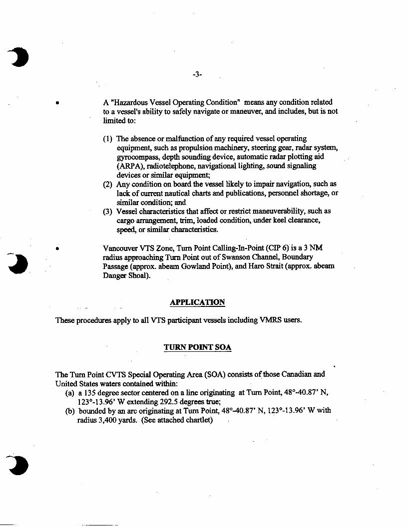
A “Hazardous Vessel Operating Condition” means any condition related to a vessel’s ability to safely navigate or maneuver, and includes, but is not limited to:
(1)
(2)
(3)
The absence or malfunction of any required vessel operating equipment, such as propulsion machinery, steering gear, radar system, gyrocompass, depth sounding device, automatic radar plotting aid (ARPA), radiotelephone, navigational lighting, sound signaling devices or similar equipment; Any condition on board the vessel likely to impair navigation, such as lack of current nautical charts and publications, personnel shortage, or similar condition; and Vessel characteristics that affect or restrict maneuverability, such as cargo arrangement, trim, loaded condition, under keel clearance, speed, or similar characteristics.
Vancouver VTS Zone, Turn Point Calling-In-Point (CIP 6)is a 3 NM radius approaching Turn Point out of Swanson Channel, Boundary Passage (approx. abeam Gowland Point), and Haro Strait (approx. abeam . Danger Shoal).
- APPLICATION
These procedures apply to all VTS participant vessels including VMRS users.
TURN POINT SOA
The Turn Point CVTS Special Operating Area (SOA) consists ofthose Canadian and United States waters contained within:
(a) a 135 degree sector centered on a line originating at Turn Point, 48’40.87 N, 123”~13.96’ W extending 292.5 degrees true;
(b) bounded by an arc originating at Turn Point, 48’40.87 N, 123”-13.96’ W with radius 3,400 yards. (See attached chartlet) .

4
MOVEMENT PROCEDURES
The following operating requirements apply to all vessels within or approaching the Turn Point Special Operating Area (SOA):.
1. A VTS participant shall: (a) if towing astern, do so with as short a hawser as safety and good seamanship
permits; (b) not enter if a hazardous vessel operating condition or circumstance exists
with their vessel without prior authorization from the authorities through the Sector MCTSO (See Interpretation); and
(c) as may be directed by the Sector MCTSO, not enter if a hazardous vessel operating condition or circumstance exists with another vessel within or near the Turn Point SOA.
NOTE: Under Item (1) (c), the hazardous operating condition or circumstance would be of such a serious nature as to affect the safety of the vessel, other vessels, and/or the environment. The MCTSO may invoke the powers of a Pollution Prevention Officer (PPO) as directed by the authorities.
2. A VTS participant of 100 meters or more in length shall: (a). Not enter the special area when another VI’S participant of 100 meters or
more in length is already located in the Special Operating Area (SOA) unless following astern on a similar course; and
(b) When following astern, maintain a minimum 1,000 yard separation with the vessel ahead.
3. All VTS participants shall report to “Victoria Traffic” northbound at CIP 4 (Brotchie Ledge) and CIP 5 (Hein Bank) and southbound at CIP 7 (East Point) as required by regulation. “Victoria Traffic” will provide the’necessary traffic advisory information for CIP 6 (Turn Point).
4. All VTS ‘participants shall report to “Victoria Traffic” at CIP 6 (3 NM from Turn Point) as required by regulation. “Victoria Traffic” will provide the necessary updated traffic advisory information for the Turn Point SOA.

5. All VTS participants southbound via Swanson Channel shall be provided with the necessary updated traffic advisory information by “Victoria Traffic” for the Turn Point SOA when crossing abeam a line running 180 degrees true from Mouat Point, North Pender Island, to Moresby Island.
6. All VTS participants approaching the Turn Point SOA shall verbally communicate on the VTS radio channel, VHF Channel 11,156.55 MHz, their intended navigation movements, and any .other information necessary to comply with these operational measures and to make safe passing arrangements with other VTS participantsoperating within or near the special area. Thisaction will be taken as soon afkr passing CIP 4 (Brotchie Ledge) or CIP 5 (Hein Bank) northbound, or CIP 7 (East Point) southbound as practical. For vessels southbound out of Swanson Channel for Turn Point, this action will betaken as soon aRer entering the north end of Swanson Channel as is practical. This requirement does not relieve a vessel of any duty prescribed by the International Regulations for Prevention of Collisions at Sea, 1972 (COLREGS), including the use of sound signals.