Urbanization Notes Chapter 9. Introduction: worldwide, people are moving from rural to urban areas...
86
Urbanization Notes Chapter 9
-
Upload
winfred-williams -
Category
Documents
-
view
215 -
download
0
Transcript of Urbanization Notes Chapter 9. Introduction: worldwide, people are moving from rural to urban areas...

Urbanization Notes
Chapter 9

Introduction:• worldwide, people are moving from rural to urban areas• the UN and World Bank try to keep census data on this• Today, over 50% of the world’s population lives in urban
areas• urbanization is not evenly distributed
– -in the US and Western Europe- 4 out 5 people live in urban areas
– -in India and China- 3 out of 10 people live in urban areas• but cities in India and China are growing rapidly
– -China- Shenzen- 20,000 increased to 2.5 million people in 30 years
– -India- Calcutta and Mumbai rank in the top 10 fastest growing cities

Largest World Cities
Ten Most Populous Today
Rank City Population
1 Tokyo, Japan 28 million
2 New York City, United States 20.1 million
3 Mexico City, Mexico 18.1 million
4 Mumbai, India (Bombay) 18 million
5 Sao Paulo, Brazil 17.7 million
6 Los Angeles, United States 15.8 million
7 Shanghai, China 14.2 million
8 Lagos, Nigeria 13.5 million
9 Kolkata, India (Calcutta) 12.9 million10 Buenos Aires, Argentina 12.5 million

Percent Urban Population
Fig. 13-1: Percent of the population living in urban areas is usually higher in MDCs than in LDCs.

Large Cities
Fig. 13-2: Cities with 2 million or more people. Most of the largest cities are now in LDCs.
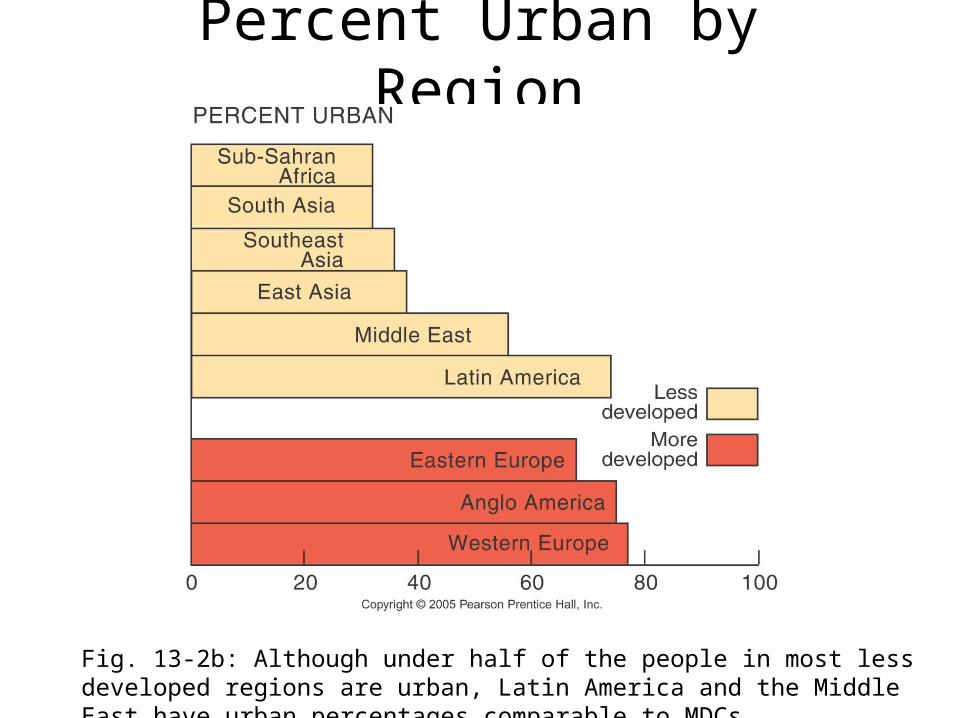
Percent Urban by Region
Fig. 13-2b: Although under half of the people in most less developed regions are urban, Latin America and the Middle East have urban percentages comparable to MDCs.
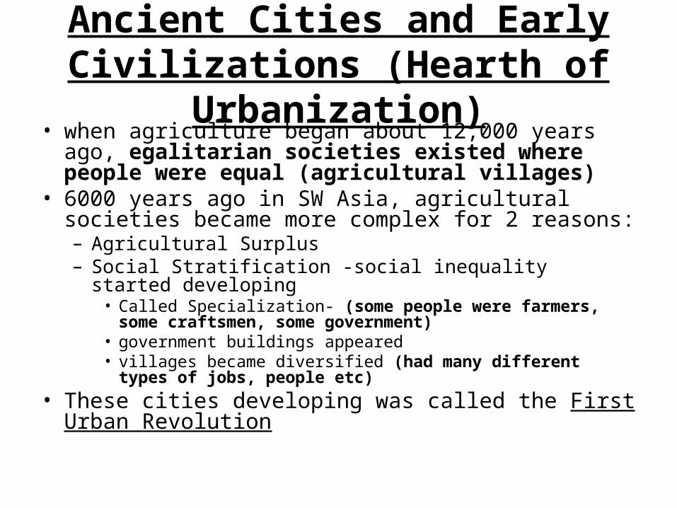
Ancient Cities and Early Civilizations (Hearth of Urbanization)
• when agriculture began about 12,000 years ago, egalitarian societies existed where people were equal (agricultural villages)
• 6000 years ago in SW Asia, agricultural societies became more complex for 2 reasons:– Agricultural Surplus– Social Stratification -social inequality started developing
• Called Specialization- (some people were farmers, some craftsmen, some government)
• government buildings appeared • villages became diversified (had many different types of jobs, people
etc)• These cities developing was called the First Urban
Revolution

Cities and States
• as settlements became larger and more specialized, there was a need for a political system
• states formed- politically organized territory administered by a sovereign government
• formative era- 7,000 BC to 5000 BC states and urbanization developed in SW Asia (Fertile Crescent between the Tigris and Euphrates Rivers)
• instead of an egalitarian society, now became a stratified society (hierarchical with many different jobs)

Location, Location, Location• geographic advantages led to the development of cities in certain
areas• important features
– proximity to farmland– availability of water– defensibility of site– trade routes
• This eventually led to the 5 hearths of urbanization:• Urbanization did not occur simultaneously (at the same time)
– 1st- Mesopotamia– 2nd- Nile Valley– 3rd- Indus River Valley (Harappa & Mohenjo Daro)– 4th- China (Huang He & Wei River Valleys)– 5th- Mesoamerica (Mayan & Aztec)

Role and Functions of Ancient Cities
• civilizations need organization for:– irrigation– collecting taxes– protection against enemies– build walls for protection– guarantee food into a city

Urbanization Created to Need For:
– food to be stored and distributed– urban elite- decision makers and organizers,
examples:– religion and philosophy (became theocratic
centers)– writing and record keeping– laws– preserving tradition

example: Mesopotamia– rulers were priests and kings who live in palaces– peasants brought harvests as a tax– stored crops– wall around the city– temples and shrines stood on high ground– shops and craftsmen– people lived in mud walled houses– the poor lived on the outskirts of town– slaves– not sanitary– garbage dumped on the streets (but this has given archeologists
lots of clues by sifting through these remains)– disease- which is why ancient cities were small
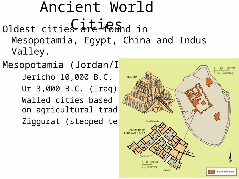
Ancient World CitiesOldest cities are found in Mesopotamia, Egypt, China
and Indus Valley.Mesopotamia (Jordan/Iraq)
Jericho 10,000 B.C. Ur 3,000 B.C. (Iraq)Walled cities based
on agricultural tradeZiggurat (stepped temple)
Ancient Ur in Iraq

cities became places where many people traveled to
• therefore, cities needed:– buildings to entertain– packaged food– process raw materials– religious places of worship– defense
• How large were ancient cities?• Mesopotamia and the Nile Valley were about
10,000-15,000– as large as food production would allow

Greece• 600-500 BC• over 500 cities and towns• Athens- largest city in the world (at this time!) 250,000
people• traders spread ideas about Greece throughout the
Mediterranean• cities were developing in China, South Asia and
Mesoamerica too• every Greek city had an acropolis- high point in the
city where large buildings stood (usually religious) example- Parthenon in Athens

Greece. . .
• agora- market place, became the center of commercial activity
• theaters- for the aristocracy• for ordinary people sanitation and health
conditions were poor• Greece was built by slaves
• Ancient Athens --------

Roman Urban System• by 114 AD the Roman Empire extended throughout Europe
and North America• largest urban system • Rome was the capital• settlements from small villages to large cities• transport network
– linked roads, rivers, and sea– urban areas located so they could be easily reached (not long
distances)– road builders increased communication throughout the empire
• used cities previously built by the Etruscans as the heart of the Roman Empire

Used the Greeks ideas:
• planning colonial cities in a rectangular grid pattern– open market as the focus of public life– theaters and arenas (Colosseum)
• aqueducts and baths• sewage system• poor were crammed in tenements (housing)• slaves in North Africa

Post Roman Decline
• collapse of the Roman Empire (495 CE) led to a collapse of its urban system
• failed because of:– misrule– corruption– external attack– environmental problems– trade and transportation network broke down
• invasion of the Moorish Empire of North Africa brought Islam

Urban Growth Elsewhere (1200-1350)
• China- Xian- known as the Rome of East Asia• West Africa- Timbuktu- major trading city and
religious center• Nile River Valley- Meroe- metallurgy to smelt iron
and develop weapons• Yucatan Penisula- Maya civilization• Mexico- Tenochtitlan- Aztecs
• Meroe Pyramids-----

Post Roman Preindustrial Europe
• Medieval Optimum- environmental period that led to warmer climates in northern Europe
• expanded farming and fishing• populations grew in northern Europe which
led to the rise of cities like Paris and London• due to better weapons, there were more
attacks• built more forts around cities

Cont. . .
• as populations increased, no room to build except up• multistory buildings• Little Ice Age- a colder climate began again
– crops failed– peasants fled to cities
• by the 17th century, cities were slums• unsanitary conditions, disease, fire• these factors led many people to go to the New World (Americas,
Australia)

Global Spread of Urbanization• before 1500 AD (before maritime exploration and overseas
colonization) cities were found in the “urban banana”- a crescent shaped zone from Europe to Asia
• often were interior cities along trade routes• after 1500AD, seaports became the dominant cities• some interior cities declined because of this• “mercantile cities” developed in Europe – cities based on
trade• formed “downtown” regions with a central square• 16th and 17th century- Europeans began expanding into
foreign lands• built mercantile cities with similar characteristics in Africa and
Asia

Industrial Revolution (2nd Urban Revolution)
• Little Ice Age brought even more people to cities, very rapidly growing population
• “manufacturing cities”- emerged based on factories, this changed cities– factories took over– ugly railroads– sanitation and water systems failed and were polluted– terrible:
• living conditions• working condition• health conditions• air quality

Cont.– children worked in factories
• eventually conditions improved due to:– government intervention– legislation (laws)– workers rights
• in the New World cities did not have all of these problems
• but inadequate planning did lead to slums and ghettoes
• during the 2nd half of the 1900s, manufacturing cities stopped growing

Cont.• factories were moved outside of cities
– NY, London, Paris and Chicago still rank in the top 10 most populated cities
– in 1975- only 5 cities with more than 10 million people
– by 2015- 23 cities with more than 10 million people• Mumbai, India will take Tokyo’s spot as the most populated
city• modern city- road construction and modern
transportation has led to an increase of suburbanization (more common in North America than Europe)

Where are Cities Located and Why??
• Place and Location• fastest growing urban area- Shenzhen, China
(20,000 to 2.5 million) . . . WHY???

Urban Situation• situation- characteristics due to relative location that
influences an area• example- Shenzhen is right next to Hong Kong and has
grown because of it• situation is key to the growth and success of certain
cities• situation describes its position relative to:
– transportation routes– farmland– manufacturing centers– distance from other towns and cities
• a city’s situation can change

Urban site• site- refers to the physical
features/qualities of the area (absolute location)– Paris- 1st settlement built along the
Seine River– Mexico City- built in a dry lake bed
• prone to earthquakes• smog pollution
– Bangkok- built in a delta of the Chao Phraya River
• pump water from wells• southern Bangkok is sinking 2 cm/year
– Singapore- island separated from Malaysia
• made it easier to secede
• Bangkok Thailand - - - - - - - - -- - - -

Urban geography- study of:
– how cities are arranged– how circulation ($) systems function– how commuting patterns develop and change– how and why people move from one part of a city
to another– why people move to cities and why others
“escape” to the suburbs
• relationship between the cities and surrounding areas

Hinterland or Trade Area:
– German word meaning the region outside the city– farmers sell products to a city’s markets– people come into the city to shop and for business– city newspapers and TV are widely viewed– layout of western cities are different than East
Asian, African or South American cities

Ranking Urban Centers– urban hierarchy-considers functions of settlements as well
as size– hamlet- has not urban function (store, gas station,
services)– village- specialization, sells goods, larger– town- higher level of specialization
• banks, post office, schools• hinterland
– city- more functional specialization• central business district• large hinterland- suburbs
• megalopolis- multiple cities that have grown together (from Boston to Washington DC)

Megalopolis
Fig. 13-4: The Boston–Washington corridor contains about one-quarter of U.S. population.

Rank Size Rule• In a model urban hierarchy, the population of a city or town will
be inversely proportional to its rank– Largest city has 12 million, it will be ranked #1– 2nd largest (ranked #2) will have 6 million- ½ of largest
populated city– 3rd largest (ranked #3) will have 4 million- 1/3 of largest
populated city– 4th largest (ranked #4) will have 3 million- ¼ of largest
populated city
• Does work in USA & many other countries, but fails to show WHERE cities will locate

Primate City RuleLargest settlement in a country has more than twice the
number as the second ranking city. These cities tend to represent the perceived culture of the country.
Largest City Population Second-largest City Population
Paris 9 million Marseille 2 millionLondon 9 million Birmingham 2 million

Primate Cities
• Mark Jefferson- Law of Primate City– Country’ leading city– Very large– represents national culture– examples- Paris and London
• Rank Size Rule Does Not Work in Countries with a Primate City!!!

Central Places
• economic reach- the maximum distance people can be from a central place and still be attracted to it for business purposes
• centrality- the strength of an urban center in its capacity to attract producers and consumers to its facilities; a city’s reach into the surrounding area

Central Place Theory
• Walter Christaller developed a model that shows how and where central places in the urban hierarchy would be functionally and spatially distributed.
• A central place provides goods and services to the surrounding region.
• In the urban model, each central place has a surrounding complementary region, an exclusive hinterland making a monopoly for sales and service.
• The physical model consists of perfectly fitted hexagonal regions.

• The model is based on a series of assumptions about urban development:– Flat Surface across all of earth- NO BARRIERS– Soil Fertility is equal EVERYWHERE– Population, money, transportation are EQUAL– From any place a good or service can be sold out a
certain distance (range of sale)

Central Place Theory• Walter Christaller : Markets and Services
tend to be nested hierarchies with smaller townsserving smallermarkets.

• These assumptions are not necessarily true, but this model still proves:– there is a hierarchy of central places (urban places
do rank)– places of same size and functions space equally apart– larger cities space further than smaller villages or
towns
• specific functions create regular rank-size patterns on a map

Central Place Theory• However, transportation and border effects
can shift the distribution of towns away from theoretical uniformity.
Transportation
Effect
Border Effect

How are Cities Organized and How do They Function?
• Urban Morphology- the layout of a city and what it can tell us about the city
• Functional Zonation- division of the city into certain regions or zones– Central Business District (CBD)- business and commerce
in the city’s downtown- high land values, tall buildings, traffic, & mass transit
– Central City- urban area that is not suburban (older city, not newer)
– Suburbs- outlying, functionally uniform part of an urban area – usually adjacent to the central city

Suburbanization- process where land outside of the urban environment becomes urbanized
• P.O. Muller wrote Contemporary Suburban America (1981) & said:– Suburbs are self sufficient urban entities & are not
an appendage of the central city– This means: suburbs have their own life and people
no longer need to travel to the central city for work, entertainment, or education like they once did
• 2000 census: 50%+ of US live in suburbs, 30.3 in central cities, & 19.7 in rural areas

Modeling the North American City
• 3 models- show us how cities have changed very quickly• Concentric Zone Model
– developed by Ernest Burgess’s study of Chicago– 5 functional concentric zones
• Central Business District (CBD)- financial, retail, theater• transition- businesses taking over residential areas• blue-collar labor force homes• middle class residences• suburbs
– model is dynamic (changing)• as cities grew, zones invaded other zones

Concentric Zone Model
Fig. 13-5: In the concentric zone model, a city grows in a series of rings surrounding the CBD.
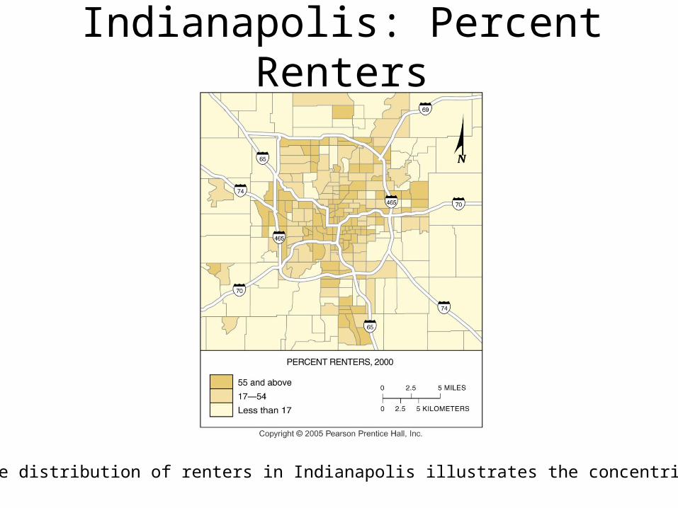
Indianapolis: Percent Renters
Fig. 13-8: The distribution of renters in Indianapolis illustrates the concentric zone model.

Sector Model
• Sector Model– developed by Homer Hoyt in the 1930s
• low rent or high rent zones could begin in CBR and extend to the outer edge

Sector Model
Fig. 13-6: In the sector model, a city grows in a series of wedges or corridors extending out from the CBD.

Indianapolis: Household Income
Fig. 13-9: The distribution of high income households in Indianapolis is an example of a sector model.

Multiple Nuclei Model
– Chauncy Harris and Edward Ullman in the 1940s– CBD- losing its dominance as the center of urban
areas– now- other centers have also developed

Multiple Nuclei Model
Fig. 13-7: The multiple nuclei model views a city as a collection of individual centers, around which different people and activities cluster.

Indianapolis: Ethnic Patterns
Fig. 13-10: The distribution of minorities in Indianapolis is an example of a multiple nuclei model.

Urban Realms Model & Edge Cities
• after WWII, the US population started to migrate to the suburbs
• edge cities- fully functional outer cities developed• suburbanization exploded• Led to the Urban Realms Model being created
– Describes the spatial components of the modern metropolis
– Each realm has their own economic, social, and political identity and is linked by the larger central city only
– Atlanta fits this model today- Think of Gwinnett County and our functions


Professionals in Glasgow
Fig. 13-11: Top professionals in Glasgow, Scotland, are more likely to live near the center of the city, in contrast to most U.S. cities.

Modeling the Modern City in the Global Periphery & Semi-Periphery
• colonial cities- former European colonies have “western” style
• indigenous cities- in the past were not influenced by western ideas but now are

Mexico City
Fig. 13-12: The Aztec city of Tenochtitlán was built on an island in Lake Texcoco. Today poorer people live on a landfill in the former lakebed, and the elite live to the west.

Fès (Fez), Morocco
Fig. 13-13: The old city has narrow winding streets and dense population. The French laid out a new district to the west with a geometric street pattern.

Ho Chi Minh City, Vietnam
Fig. 13-14: In Ho Chi Minh City (formerly Saigon), the French demolished the previous city and replaced it with a colonial design with boulevards and public squares.

The Ibero-American City
• South and Middle America is urbanizing rapidly
• 1950- 41%• now- 77%• Draw the model on p.279, label and DESCRIBE
each zone or section:

Latin American City Model
Fig. 13-15: In many Latin American cities, the wealthy live in the inner city and in a sector extending along a commercial spine.

Rio de Janeiro, Brazil
Fig. 13-16: High income households in Rio de Janeiro live in the CBD and in a spine along the ocean. Low-income households often live in peripheral areas.

Southeast Asian City
• old colonial port zone is the focus• commercial district surrounds it• no formal CBD• Draw the model on p.281, label and DESCRIBE
each zone or section:
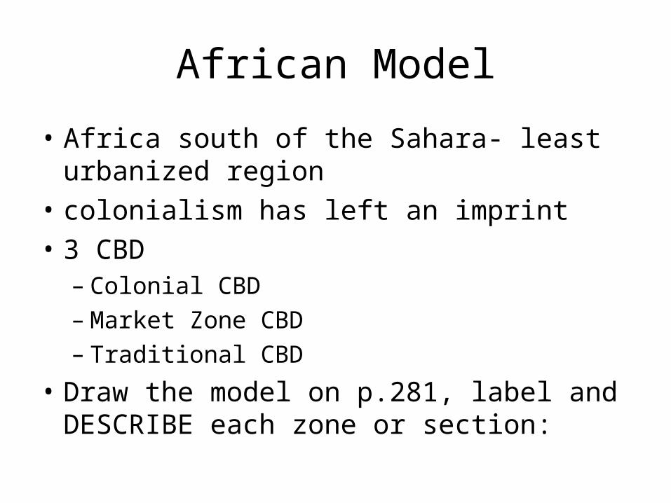
African Model
• Africa south of the Sahara- least urbanized region
• colonialism has left an imprint• 3 CBD
– Colonial CBD– Market Zone CBD– Traditional CBD
• Draw the model on p.281, label and DESCRIBE each zone or section:

How do People Make Cities?
• Cultural and Social forces shape the character of cities and influences who lives where
• Sociocultural characteristics are evident in:– the style of the house– distance between houses– yards
• ethnic neighborhoods:– found in urban areas
• usually forced by the dominant groups (example- segregation)

Cities in the Periphery & Semiperiphery
• “pull” factors of economic opportunities often brought people to the city
• shantytowns formed to deal with the increasing population– unplanned developments with crude dwellings and
shelters• this does not deter immigrants• 1990s- fastest growing cities found in
– Africa– South Asia– East Asia

Changes in Cities in LDCs
Populations of cities in the less developed world have been surging: urbanization, migration, natural increase
Urbanization in LDCs: driven by changes in economy the poor live in the suburbs, rich live in CBD cities struggle to provide jobs and housing services overtaxed squatter settlements common crime on the rise
Rio De Janeiro, Brazil

• the wealthier regions are growing very slowly• cities in poorer countries often lack zoning laws• zoning- ensures space is used effectively (example- factory
won’t be built in your neighborhood)• In Chennai, India, the space between high rise buildings has
squatter settlements• In Bangkok- a school is next to a polluting factory• many countries are starting to enforce zoning laws• in most megacities- economic stratification between the rich
and the poor is obvious• How is this evident in our cities?

Making Cities in the Global Core
• Racial discrimination in the urban land market• 1960s- no legal barriers to racial
discrimination and segregation but clear racial ghettos formed to keep blacks our of white neighborhoods
• redlining- banks would identify “risky” neighborhoods and refuse loans (marked with red lines on a map)

blockbusting- turn over in housing (now illegal)
– real estate agents convince an African American person to buy a house in a white neighborhood
– would sell house VERY cheap– this produced “white flight” to suburbs
• then more houses are sold- more commission money for real estate agents!

Gentrification
• - Moving back to the central cities when people buy up and rehabilitate houses– This raises the land value and can happen in the
suburbs as well– Usually occurs with Tear-Downs- buying a house
w/the intention of tearing it down to build huge house
• New large homes are called McMansions b/c they are super-sized


• racial steering- convince people to move into ghettoes to transform neighborhoods
• gated communities- common to protect against dangers of an urban area– Fenced-in neighborhoods w/controlled access– Found all over the world after development in the
US (late 80’s)– New way for segregation – now economic
segregation instead of racial


Peripheral Model of Urban Areas
Fig. 13-19: The central city is surrounded by a ring road, around which are suburban areas and edge cities, shopping malls, office parks, industrial areas, and service complexes.

Urban Sprawl• Unrestricted growth of housing, commercial developments, and roads
over large expanses of land, with little concern for urban planning.• Mainly caused by automobiles
– Can live further from city (work) and still get there w/cars– Causes people to move further into suburbs and land to be torn down
and converted to urban use• New Urbanism- the desire to turn public spaces into private use
– Ex: neighborhood only shopping, swimming, tennis, playgrounds, etc– Thought to work against urban sprawl– Cuts out traffic, driving, b/c all goods needed are w/in walking
distance• List top 5 cities from chart on p. 288:

New Urbanism


Suburban Development in the U.S. and U.K.
Fig. 13-21: New housing in the U.K. is likely to be in planned new towns, while in the U.S. growth occurs in discontinuous developments.


What Role do Cities Play in Globalization?
• World Cities- Cities that function at the global scale, beyond the reach of the state borders, functioning as the service centers of the world economy– Major economic and cultural hearth functions as
well– Function as Global markets for goods (stock
markets, trading values, etc)

Cities as Spaces of Consumption
• Cities seen on TV & media are helping to transform urban centers into major entertainment districts
• Much like a theme park! – Ex: Times Square for restaurants, hotels, bars,
entertainment places • Companies such as Sony, Times Warner, ESPN, etc.
use cities to promote their goods on a global scale– Ex: ESPN Zone, Disney Store, Hard Rock Café seen
on tv, radio, & movies