Update from Coastal Resources Management Council ...€¦ · Rhode Island Coastal Resources...
62
EBC Rhode Island Program Update from Coastal Resources Management Council Leadership Team
Transcript of Update from Coastal Resources Management Council ...€¦ · Rhode Island Coastal Resources...

EBC Rhode Island Program
Update from Coastal Resources
Management Council Leadership Team
Welcome
Rick Mandile
Chair, EBC Rhode Island Chapter
Principal
SAGE Environmental
Environmental Business Council of New England
Energy Environment Economy

Thank you to our Co-Host

Program Introduction
Igor Runge
Program Chair & Moderator
Senior Consultant
GZA GeoEnvironmental, Inc.
Environmental Business Council of New England
Energy Environment Economy

Update from the RI Coastal Resources
Management Council
Grover Fugate
Executive Director
Rhode Island Coastal Resources
Management Council
Environmental Business Council of New England
Energy Environment Economy


Three Threats the Plan will Address
• Sea Level Rise
• Storm effects
• Erosion
These forces interact in a synergistic fashion that adds to their destructive force.
For example one foot of sea level rise jumps the recurrence level so that the once in one hundred year storm now has a return probability of one in fifty. Two feet and that jumps once in 25 years and 5 feet is like having a once 100 year storm once a day.

New NOAA Estimate from Report Released January 2017
• Just released NOAA predicts a Global High Estimate for the Newport tide gage the 83% confidence interval of 9.6 feet. For the built environment we need to consider a Extreme High Tide events that can add to 1.5 to 2 feet to the average high tide, this then would essentially be 12 feet by 2100.
From the report: “The growing evidence of accelerated ice loss from Antarctica and Greenland only strengthens an argument for considering worst-case scenarios in coastal risk management.”
Extreme GMSL by 2200 projected to be 9.7M (31.8 feet). This SLR scenario will inundate most every coastal city worldwide.
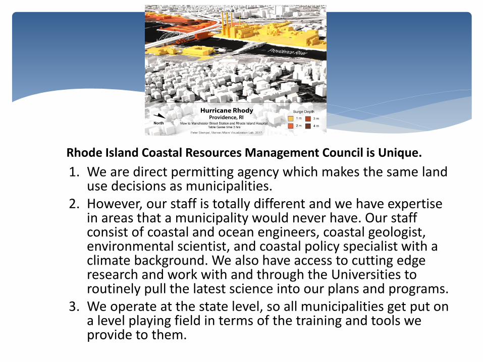
Rhode Island Coastal Resources Management Council is Unique.
1. We are direct permitting agency which makes the same land use decisions as municipalities.
2. However, our staff is totally different and we have expertise in areas that a municipality would never have. Our staff consist of coastal and ocean engineers, coastal geologist, environmental scientist, and coastal policy specialist with a climate background. We also have access to cutting edge research and work with and through the Universities to routinely pull the latest science into our plans and programs.
3. We operate at the state level, so all municipalities get put on a level playing field in terms of the training and tools we provide to them.

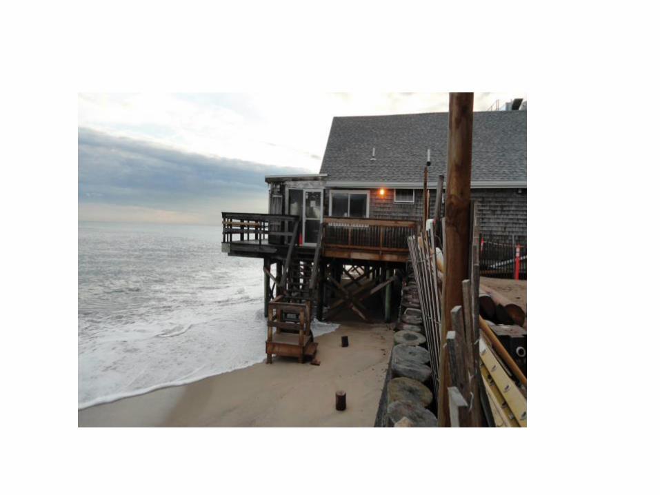
The Watch Hill Yacht Club

1991

Flood Zones(2009, left and 2013, right) Misquamicut Barrier
2-3 ft reduction in Base Flood Elevation (BFE)
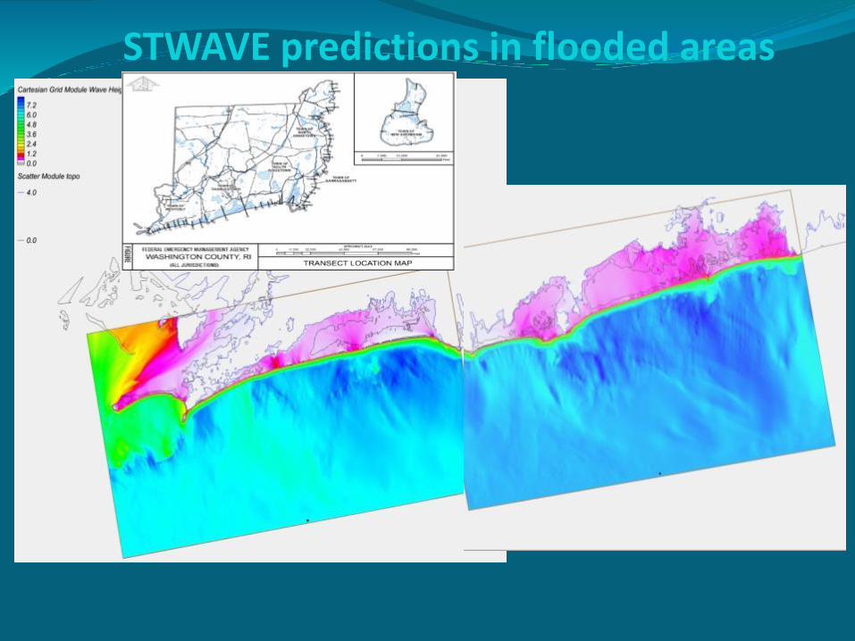
STWAVE predictions in flooded areas

These maps are made by consulting firms using assumptions that do not reflect Rhode Island conditions.
• For example there is an assumed dune profile that FEMA contractors default to called the 540 rule. This dune profile is much larger than our actual dunes. In fact, the 540 dune is larger in volume in a post storm condition, than our dunes are before the storm.
• FEMA has under estimated the wave conditions offshore. The wave conditions are used as the input value for their transect model. The recent maps have offshore waves from a 100 year event at 4 meters. Hurricane Irene which was a 25 year event generated waves offshore of 4.2 meters. The data and model runs for offshore conditions in our area show that a 100 year event should be 9 metes. Thus they are using half of the value that should be used to run the transect models.
• Too few transects to represent spatial variability in the study area (violates FEMA guidance)
• 1 D wave model (FEMA) cannot capture 2-D wave processes (STWAVE).
Technical Issues with FEMA FIRMs

CERI BFE (left panel) and FEMA BFE (right panel)

The Climate Problem with the FEMA maps
Actuarial based system- in today’s world that is like driving down 95 only using your rear view mirror.
Current code requires 1 foot of freeboard above base flood elevation (BFE)
We are expecting 1 foot of SLR in 20 years That means when you reach the end of your 30 year
mortgage you are below BFE Prior to the hurricane season of 2017, FEMA was $25 billion
in debt. In order to be stainable in the future FEMA must head
towards full actuarial rates So do you build for today’s world or tomorrow’s?

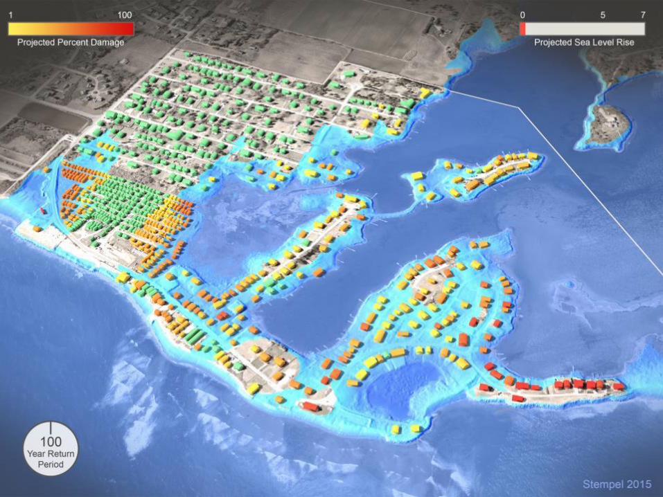
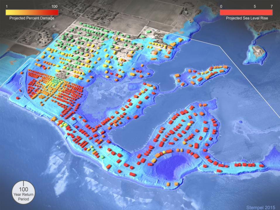
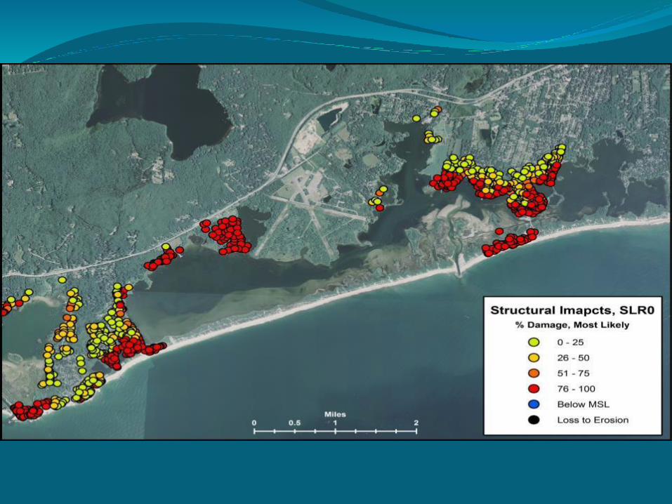
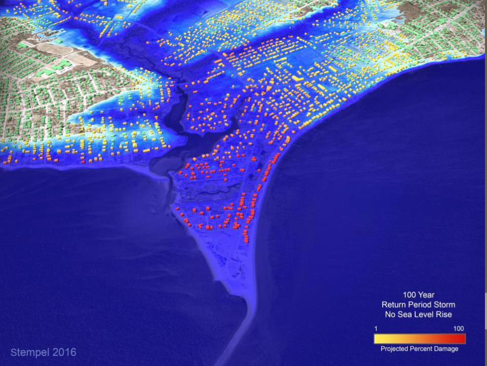
EXPOSED RESIDENTIAL STRUCTURES: COMBINED 21 COASTAL
COMMUNITIES
Rank SLR 3 ft SLR 5 ft SLR 7 ft 100 YR STORM SURGE
1 South Kingstown Westerly Westerly Warwick
2 Westerly South Kingstown South Kingstown Barrington
3 Narragansett Newport Warwick South Kingstown
4 Charlestown Narragansett Narragansett Warren
5 Tiverton Warren Newport Westerly
Scenarios

Coastal Environmental Risk Index

CERI Building Blocks
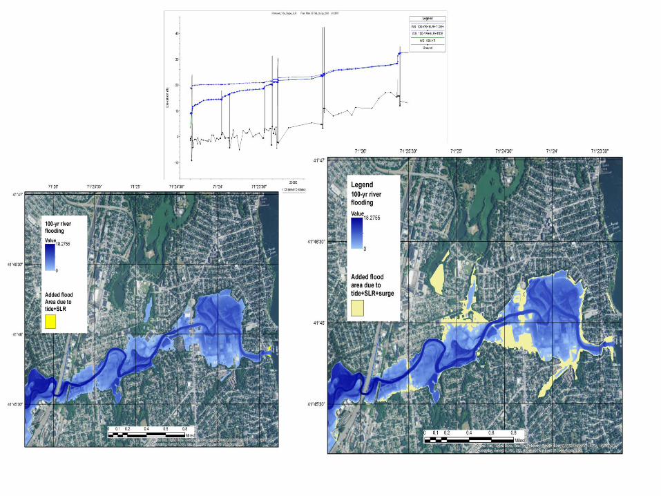
Water levels (100 yr.. or specific storm event) for flooding, with or without SLR, available from STORMTOOLs. (http://www.beachsamp.org/resources/stormtools/)
Wave estimates (100 yr..) for flood inundated areas, with and without SLR based on state of the art wave models.
Shoreline change (erosion/accretion) estimates based on most recent 2016 RI CRMC shoreline change maps.
Damage functions by structure or infrastructure type based on data from superstorm Sandy (2012) (US Army Corp of Engineers(ACOE)/FEMA)).
Location/identification of individual structures and infrastructure from E911 and town and state data bases.

Army Corp Engineers-North Atlantic Comprehensive Coastal Study (NACCS) Structure Type
5
6
7
A B


ID LON LATHOUSE TYPE
FFE (m)
5391 -71.6432 41.3706 6B 0.6
5413 -71.6423 41.3700 6B 0.6
5418 -71.6417 41.3702 6B 0.6
5470 -71.6416 41.3705 6B 0.6
5425 -71.6415 41.3707 5A 0.6
5473 -71.6410 41.3709 6B 0.6
5470
5391
5413
5418
54255473
DAMAGE ESTIMATION - CLOSE UP
HOUSE PARAMETERS
TOPO DEM (M)
SURGE NAVD88
WAVE CREST NAVD88
WAVE HEIGHT
1.7 4.8 5.8 1.0
2.5 4.8 5.9 1.1
2.7 4.8 5.8 1.0
2.9 4.8 5.8 1.0
2.9 4.8 5.7 1.0
2.5 4.8 5.7 1.0
ENVIRONMENTAL PARAMETERS
5470


Wind Protocol
37
http://callcarefirst.com/for-home/wind-damage/
1. Location of Structure
2. Structure Type
3. Surface Roughness
4. Distribution
5. Wind Gust Speed

Results: Damage from Wind
38
Most likely wind damage distribution
for Misquamicut study area.
Surface Roughness Dominates Structure Type Dominates


Shoreline Change (Beach)
Special Area Management Plan
•Beach SAMP will be a guidance document to support regulatory changes (CRMC policy & standards)
•Regulatory changes will be made to the RI Coastal Resources Management Program (aka “Red Book”) & other existing SAMPs

Shoreline Change Special Area Management Plan (Beach SAMP)
Volume 1
Executive Summary
1. Introduction
2. Coastal Hazards in RI
3. Assessing Coastal Risk
4. RI’s Exposure to Coastal Hazards
5. RICRMC Application Guidance
6. State Agency & Municipal Considerations
7. Adaptation Strategies
Volume 2• Technical Reports of
Research
• Compendium of Adaptation Techniques/Strategies

Chapter 2: Trends and Status

Steps for Addressing Coastal Hazards in Coastal Development Planning
STEP 1: PROJECT DESIGN LIFE
STEP 2: SITE ASSESSMENT & BASE FLOOD ELEVATION
STEP 3: LARGE PROJECTS
STEP 4: DESIGN EVALUATION
STEP 5: SUBMIT AN APPLICATION
In this step, the applicant will choose an appropriate design life, or lifespan, for the project, and identify a projected sea level for the project site based on the selected design life.
In this step the applicant will review specified maps and tools to assess the exposure and potential risk from coastal hazards at the project site.
This step is for Large Projects and Subdivisions only. If not such a project, this step may be skipped.
The applicant will identify, document, and assess the feasibility of design techniques that could serve to avoid or minimize risk of losses.
The applicant will submit the permit application and include the assessment from the previous steps in the application package to the CRMC.

45

46

47

Federal Consistency
Workshop
Office of Ocean and Coastal Resource Management
National Oceanic and Atmospheric Administration
http://coastalmanagement.noaa.gov/welcome.html
http://coastalmanagement.noaa.gov/consistency/welcome.html

It’s An “Effects Test”. . .
(See CZMA Section 307 (16 U.S.C. § 1456))
Federal Consistency is the requirement that
Federal actions, in or outside the coastal zone,
that affect any land or water use or natural
resource of a State’s coastal zone must be
consistent with the enforceable policies of
State Coastal Management Programs.

“Federal Actions”
• Federal Financial Assistance to State or Local AgenciesCZMA 307(d), 15 CFR part 930, subpart F
• Federal Agency Activities & Development ProjectsCZMA 307(c)(1), (2), 15 CFR part 930, subpart C
• Federal License or Permit Activities(non-federal applicants)
CZMA 307(c)(3)(A), 15 CFR part 930, subpart D
• Outer Continental Shelf PlansCZMA 307(c)(3)(B), 15 CFR part 930, subpart E

Coastal Effects
State
Coastal
Uses and
Resources
Federal Agency
Activities
Federal Authorization
Activities
Military Facilities
Dredging
Wildlife Refuge
Expansion
Fishery Plans
Gas Pipelines
OCS Oil & Gas
Leasing
Timber Sales
Navigation Aids
OCS Oil & Gas Plans
Hydro-elec Licenses
Land Disposal
Wetland Alteration
ESA Permits
LNG Terminals
Airport Layout Plans
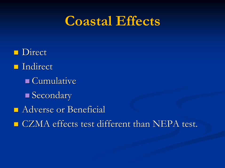
Coastal Effects
Direct
Indirect
Cumulative
Secondary
Adverse or Beneficial
CZMA effects test different than NEPA test.

Enforceable Policies
• Legally binding under State Law
• Apply to State Jurisdiction and not Federal areas or agencies
• Not Preempted by Federal Law
• Do not discriminate against a particular group or activity
• Consistent with CZMA requirements
• Once superseded by other State law, no longer enforceable
• Approved by NOAA
• Input by Federal agencies and the public
• No incorporation by reference

Enforceable Policies
• EPs need to contain some level of specificity sufficient to determine
compliance (to be consistent, a person/entity must do “x” or
cannot do “y”). However, even if a policy may not be applied
through federal consistency, it could still be an enforceable policy.
– Examples: permit regulations regarding fines, an appeals process,
an exemption for a state agency, etc., are an integral part of a
regulatory program and enforceable under state law, but may not
be applied through federal consistency.
• Policies may be enforceable under state law but not enforceable
policies for CZMA federal consistency purposes.
• Examples: the state DNR shall promulgate rules for public
access, establish a program to manage invasive species, develop
a sea level rise adaptation plan, etc. These examples are
authorities or directives and substantive standards.

Differences
Between Subpart C and D Requirements
Activities Undertaken by a Federal Agency Federal Licenses and Permits
Submission of a consistency determination Submission of a consistency certification
Submitted at least 90 days before final action Submitted with/after license or permit application
State has 60 (plus 15) days to review State has 6 months to review
Review starts when CD received (if complete) Review starts when CC and ND&I submitted (if
complete)
“consistent to the maximum extent practicable” Fully consistent
Federal agency can proceed over objection If objection, federal agency may not authorize the
activity – applicant may appeal state objection to
Secretary of Commerce
State can bring suit in court to enforce objection or
seek mediation
Either or both parties can bring suit in court only
after a decision issued by the DOC Secretary on
appeal by the license or permit applicant
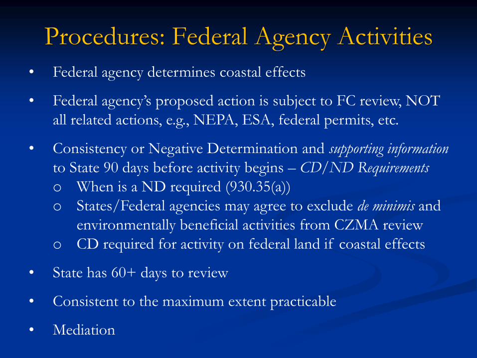
Procedures: Federal Agency Activities
• Federal agency determines coastal effects
• Federal agency’s proposed action is subject to FC review, NOT
all related actions, e.g., NEPA, ESA, federal permits, etc.
• Consistency or Negative Determination and supporting information
to State 90 days before activity begins – CD/ND Requirements
o When is a ND required (930.35(a))
o States/Federal agencies may agree to exclude de minimis and
environmentally beneficial activities from CZMA review
o CD required for activity on federal land if coastal effects
• State has 60+ days to review
• Consistent to the maximum extent practicable
• Mediation

License or Permit Activities
• Listed or unlisted in State program
• Applicant may appeal objection to Secretary
• State objection = Federal agency cannot approve
• State review up to 6 months
• Project must be fully consistent
• Consistency certification to State
• Inside or Outside Coastal Zone
• Non-Federal Applicants

Inside CZ – Unlisted
Effects NOT Presumed
State Needs NOAA Approval
Inside CZ – Listed
Effects Presumed
FC Applies
State Waters –
Rhode Island
R.I.
M.A.
All Reviews are if Rhode Island is Seeking Review
(Same scenario would apply on land)
Outside CZ – Inside Geo Loc
Unlisted – Effects NOT Presumed
State Needs NOAA Approval
Outside CZ – Inside Geo Loc
Listed – Effects Presumed
FC Applies
Other State – Subpart I
Inside Geo Loc – Listed
Effects Presumed – FC Applies
Outside CZ – Outside Geo Loc
Listed or Unlisted
Effects NOT Presumed
State Needs NOAA Approval
Other State – Subpart I
Outside Geo Loc – Listed or Unlisted
Effects NOT Presumed
State Needs NOAA Approval
Other State
NO Subpart I
NO FC Review
State Waters – Mass.
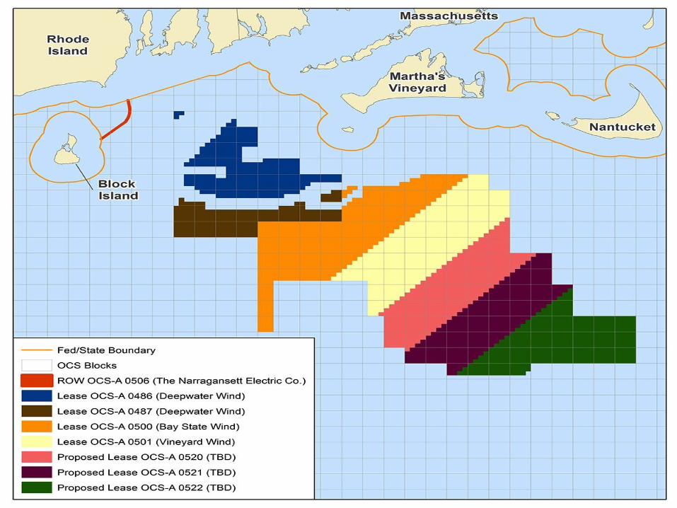
FEDERAL WATERS
CZMA 307(c)(3)(A) License or Permit Map


Moderated Discussion
Moderator: Igor Runge, GZA
Panelists:
• Grover Fugate, Executive Director
• Jeffrey Willis, Deputy Director
• James Boyd, Coastal Policy Analyst
Environmental Business Council of New England
Energy Environment Economy

EBC Rhode Island Program
Update from Coastal Resources
Management Council Leadership Team