State or Private Protection against Maritime Piracy? - Clingendael
UNOSAT Global Reporton Maritime Piracya geospatial analysis 1995-2013
Contents Preface 4Executive Summary 5
Introduction and methodology 6Global overview 8The context of global piracy 12
Geospatial analysesThematic approach 22Regional specificity 30
Conclusion and recommendations 38
Source for all figures: Global Integrated Shipping Information System (GISIS), International Maritime Organization (IMO), except for the listed below.
Figure 2: IMO and National Center for Ecological Analysis and Synthesis, Ecosystem-based Management of Coastal Marine Systems http://portal.nceas.uesb.edu/ and http://ebm.nceas.uesb.edu/GlobalMarine/impacts/transformed/
Figure 5: Atlas 2014 des enjeux maritimes, Editions Le Marin, Rennes (France); American Association of Port Authorities (AAPA); US department of Commerce, Bureau of Industry and Security.
Figure 6: Maritime Strategies International Ltd; Lloyd’s Register Group Limited.
Figures 7, 8, 21: The economic cost of Somali piracy 2011 and 2012, The human cost of maritime piracy 2012, One Earth.
Figure 9: NATO; Maritime Security Centre – Horn of Africa (MSCHOA); EU NAVFOR; Maritime Piracy – Humanitarian Response Programme; Global Policy Foum (GPF)
Figure 10: A secret subsidy: Oil companies, the Navy & the response to piracy, Platform London; Mail Online, December 2011; Lowy Institute, September 2012; Maritime Security Review, July 2013.
Figure 19: United Nations Convention on the Law of the Sea (UNCLOS); Sea Around Us Project.
Figure 33: Atlas 2014 des enjeux maritimes, Editions Le Marin, Rennes (France); Global Insight; Asian Development Bank (ADB): Financial Time, 10 December 2007; Eurasianet; Interstate Oil and Gas Transport to Europe (INOGATE); Transport Corridor Europe-Caucasus-Asia (TRACECA), Energy Map of the Middle East and Caspian Sea Areas, Petroleum Economist, London, 2013; Arctic Monitor.
ContributorsPhilippe Leymarie, Philippe Rekacewicz, Agnès Stienne.
Support teamEinar Bjørgo, Francesco Pisano,Olivier van Damme, Adam Ali,Philippe Rivière.
This report has been produced with the kind contribution of the Government of Sweden.
DisclaimerThe views expressed in this publication are not necessarily those of the United Nations Institute for Training and Research (UNITAR). The presentations and the designations employed do not imply the expression of any opinion whatsoever on the part of the cooperating divisions concerning the legal status of any country, territory, city or area or of its authorities, or of the delineation of its frontiers or boundaries. Mention of a commercial company or product in this report does not imply endorsement by UNITAR.
UNOSAT is a program of the United Nations Institute for Training and Research (UNITAR), providing satellite imagery and related geographic information, research and analysis to UN humanitarian & development agencies & their implementing partners.
This publication may be reproduced in whole or in part and in any form for educational or non-profit purposes without special permission from the copyright holder, provided acknowledgement of the source is made. UNITAR would appreciate receiving a copy of any material that uses this publication as a source.
This work by UNITAR/UNOSAT is licensed under a Creative Commons Attribution-NonCommercial-ShareAlike 3.0 Unported License.
Copyright © United Nations Institute for Training and Research (UNITAR), 2014.
UNOSAT Global Reporton Maritime Piracya geospatial analysis 1995-2013
Following a five year engagement by the United Nations Institute for Training and Research (UNITAR) to conduct applied research and geospatial analysis on piracy activities, this report constitutes the first global geospatial analysis. What started with identifying captured ships delivering humanitarian assistance and other goods using satellite imagery later expanded to regional geospatial analyses for the western Indian Ocean. The current report assesses piracy at the global level. This research includes detailed geo-spatial analyses, while relating findings to complementary factors, including references to specific examples illustrating the complexity of the piracy issue. The report also covers the financial aspects of global piracy, as well as anti-piracy activities and future outlooks in a changing meteorological climate.
The work takes into account studies from different sources, such as UN sister agencies, academia, insurance industry, shipping companies, European Commission and the World Bank. This report should be seen as a contribution to the important and ongoing debate on maritime piracy taking place in numerous fora, including the Contact Group on Piracy off the Coast of Somalia and others. This research and current report have been made possible due to financial contribution from the Government of Sweden.
Preface
4 | UNOSAT Global Report on Maritime Piracy
a geospatial analysis 1995-2013 | 5
Executive Summary
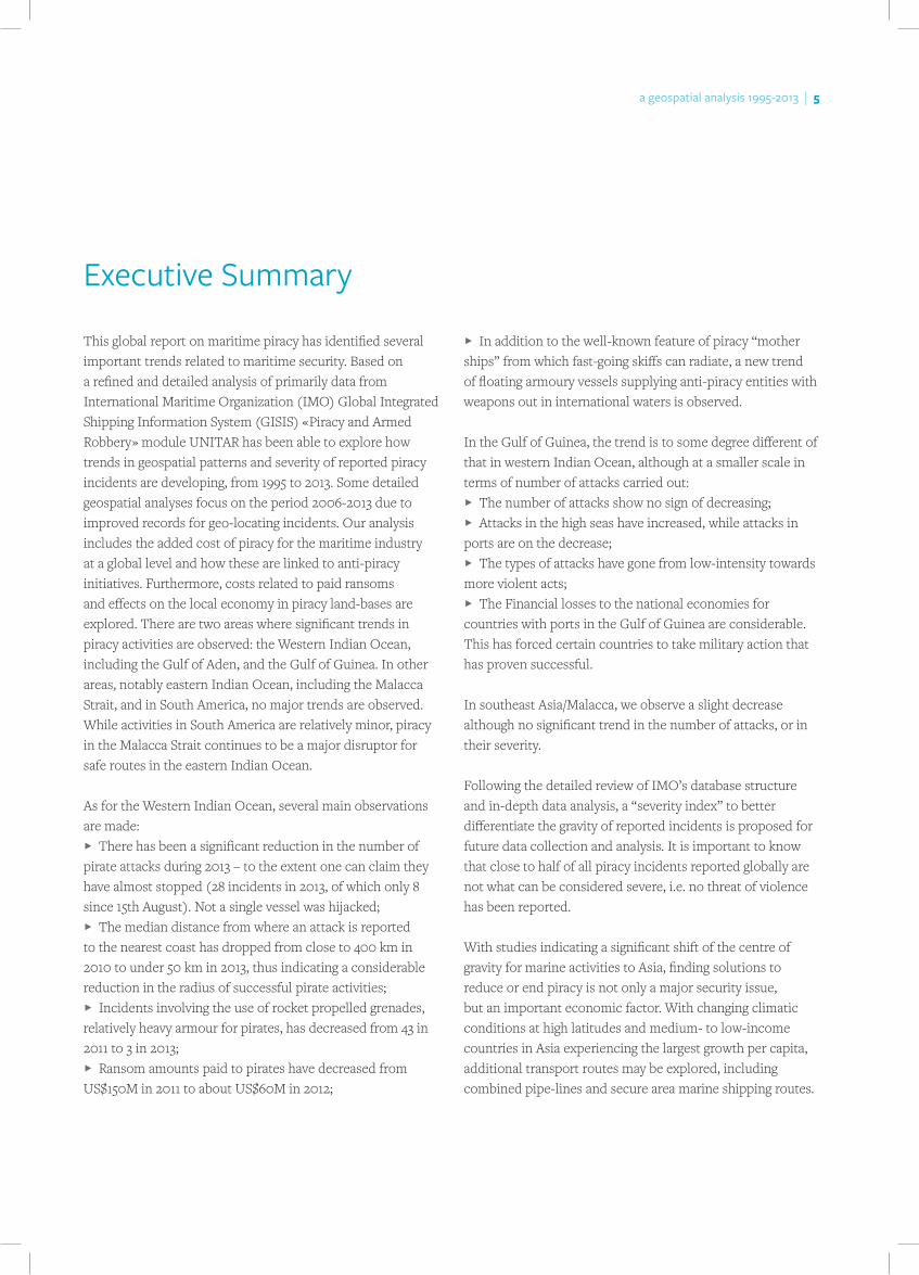
This global report on maritime piracy has identified several important trends related to maritime security. Based on a refined and detailed analysis of primarily data from International Maritime Organization (IMO) Global Integrated Shipping Information System (GISIS) «Piracy and Armed Robbery» module UNITAR has been able to explore how trends in geospatial patterns and severity of reported piracy incidents are developing, from 1995 to 2013. Some detailed geospatial analyses focus on the period 2006-2013 due to improved records for geo-locating incidents. Our analysis includes the added cost of piracy for the maritime industry at a global level and how these are linked to anti-piracy initiatives. Furthermore, costs related to paid ransoms and effects on the local economy in piracy land-bases are explored. There are two areas where significant trends in piracy activities are observed: the Western Indian Ocean, including the Gulf of Aden, and the Gulf of Guinea. In other areas, notably eastern Indian Ocean, including the Malacca Strait, and in South America, no major trends are observed. While activities in South America are relatively minor, piracy in the Malacca Strait continues to be a major disruptor for safe routes in the eastern Indian Ocean.
As for the Western Indian Ocean, several main observations are made:F There has been a significant reduction in the number of pirate attacks during 2013 – to the extent one can claim they have almost stopped (28 incidents in 2013, of which only 8 since 15th August). Not a single vessel was hijacked; F The median distance from where an attack is reported to the nearest coast has dropped from close to 400 km in 2010 to under 50 km in 2013, thus indicating a considerable reduction in the radius of successful pirate activities; F Incidents involving the use of rocket propelled grenades, relatively heavy armour for pirates, has decreased from 43 in 2011 to 3 in 2013;F Ransom amounts paid to pirates have decreased from US$150M in 2011 to about US$60M in 2012;
F In addition to the well-known feature of piracy “mother ships” from which fast-going skiffs can radiate, a new trend of floating armoury vessels supplying anti-piracy entities with weapons out in international waters is observed.
In the Gulf of Guinea, the trend is to some degree different of that in western Indian Ocean, although at a smaller scale in terms of number of attacks carried out:F The number of attacks show no sign of decreasing;F Attacks in the high seas have increased, while attacks in ports are on the decrease;F The types of attacks have gone from low-intensity towards more violent acts;F The Financial losses to the national economies for countries with ports in the Gulf of Guinea are considerable. This has forced certain countries to take military action that has proven successful.
In southeast Asia/Malacca, we observe a slight decrease although no significant trend in the number of attacks, or in their severity.
Following the detailed review of IMO’s database structure and in-depth data analysis, a “severity index” to better differentiate the gravity of reported incidents is proposed for future data collection and analysis. It is important to know that close to half of all piracy incidents reported globally are not what can be considered severe, i.e. no threat of violence has been reported.
With studies indicating a significant shift of the centre of gravity for marine activities to Asia, finding solutions to reduce or end piracy is not only a major security issue, but an important economic factor. With changing climatic conditions at high latitudes and medium- to low-income countries in Asia experiencing the largest growth per capita, additional transport routes may be explored, including combined pipe-lines and secure area marine shipping routes.
0
50
1995 2005 2010 2013
South America
2000 1995 2005 2010 2013
Western Indian Ocean
20000
50
100
150
200
250
300
0
50
100
150
200
250
1995 2005 2010 2013
Southeast Asia
20000
50
100
1995 2005 2010 2013
West Africa
2000
Severity 2, 3 and 41
Severity 11
Number of attacks
1. See severity levels page 11
Figure 1: Acts of piracy and armed robbery, 1995-2013
6 | UNOSAT Global Report on Maritime Piracy
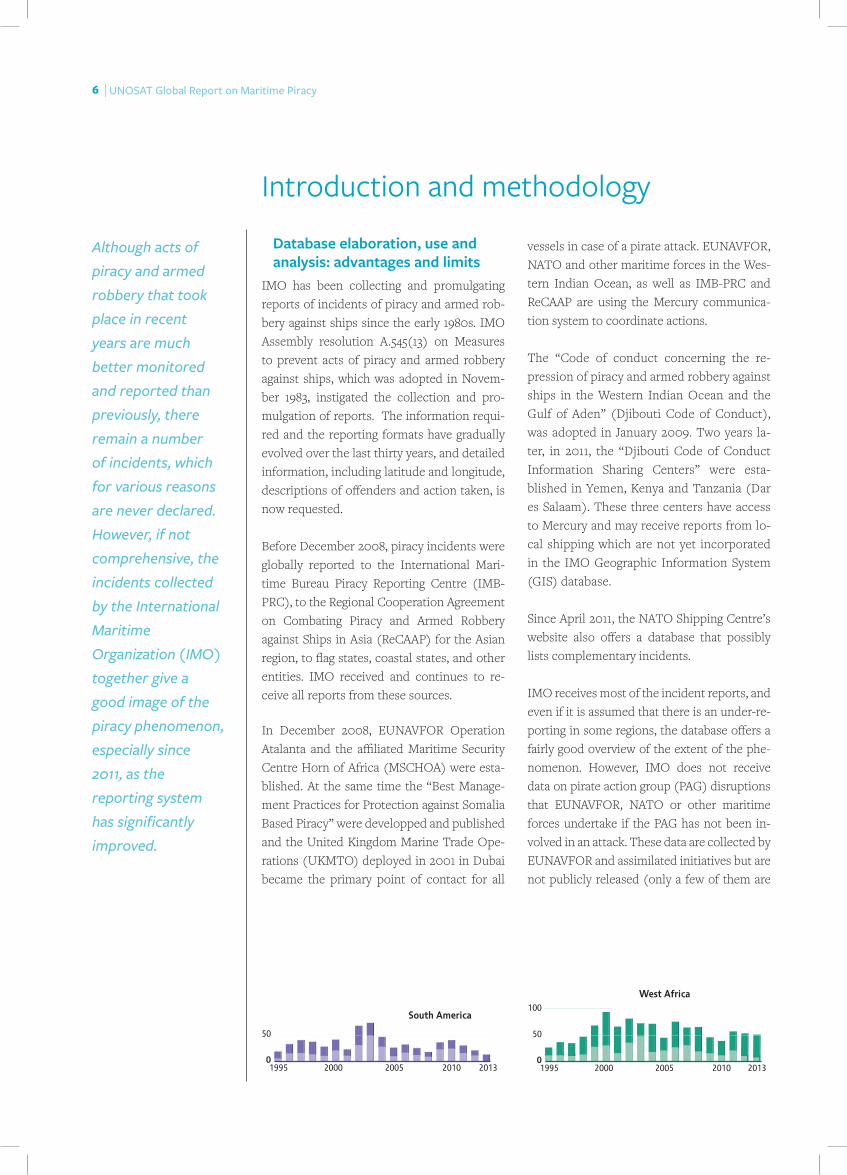
Although acts of piracy and armed robbery that took place in recent years are much better monitored and reported than previously, there remain a number of incidents, which for various reasons are never declared. However, if not comprehensive, the incidents collected by the International Maritime Organization (IMO) together give a good image of the piracy phenomenon, especially since 2011, as the reporting system has significantly improved.
Introduction and methodology
vessels in case of a pirate attack. EUNAVFOR, NATO and other maritime forces in the Wes-tern Indian Ocean, as well as IMB-PRC and ReCAAP are using the Mercury communica-tion system to coordinate actions.
The “Code of conduct concerning the re-pression of piracy and armed robbery against ships in the Western Indian Ocean and the Gulf of Aden” (Djibouti Code of Conduct), was adopted in January 2009. Two years la-ter, in 2011, the “Djibouti Code of Conduct Information Sharing Centers” were esta-blished in Yemen, Kenya and Tanzania (Dar es Salaam). These three centers have access to Mercury and may receive reports from lo-cal shipping which are not yet incorporated in the IMO Geographic Information System (GIS) database.
Since April 2011, the NATO Shipping Centre’s website also offers a database that possibly lists complementary incidents.
IMO receives most of the incident reports, and even if it is assumed that there is an under-re-porting in some regions, the database offers a fairly good overview of the extent of the phe-nomenon. However, IMO does not receive data on pirate action group (PAG) disruptions that EUNAVFOR, NATO or other maritime forces undertake if the PAG has not been in-volved in an attack. These data are collected by EUNAVFOR and assimilated initiatives but are not publicly released (only a few of them are
Database elaboration, use and analysis: advantages and limits
IMO has been collecting and promulgating reports of incidents of piracy and armed rob-bery against ships since the early 1980s. IMO Assembly resolution A.545(13) on Measures to prevent acts of piracy and armed robbery against ships, which was adopted in Novem-ber 1983, instigated the collection and pro-mulgation of reports. The information requi-red and the reporting formats have gradually evolved over the last thirty years, and detailed information, including latitude and longitude, descriptions of offenders and action taken, is now requested.
Before December 2008, piracy incidents were globally reported to the International Mari-time Bureau Piracy Reporting Centre (IMB-PRC), to the Regional Cooperation Agreement on Combating Piracy and Armed Robbery against Ships in Asia (ReCAAP) for the Asian region, to flag states, coastal states, and other entities. IMO received and continues to re-ceive all reports from these sources.
In December 2008, EUNAVFOR Operation Atalanta and the affiliated Maritime Security Centre Horn of Africa (MSCHOA) were esta-blished. At the same time the “Best Manage-ment Practices for Protection against Somalia Based Piracy” were developped and published and the United Kingdom Marine Trade Ope-rations (UKMTO) deployed in 2001 in Dubai became the primary point of contact for all
0
50
1995 2005 2010 2013
South America
2000 1995 2005 2010 2013
Western Indian Ocean
20000
50
100
150
200
250
300
0
50
100
150
200
250
1995 2005 2010 2013
Southeast Asia
20000
50
100
1995 2005 2010 2013
West Africa
2000
Severity 2, 3 and 41
Severity 11
Number of attacks
1. See severity levels page 11
Figure 1: Acts of piracy and armed robbery, 1995-2013
a geospatial analysis 1995-2013 | 7
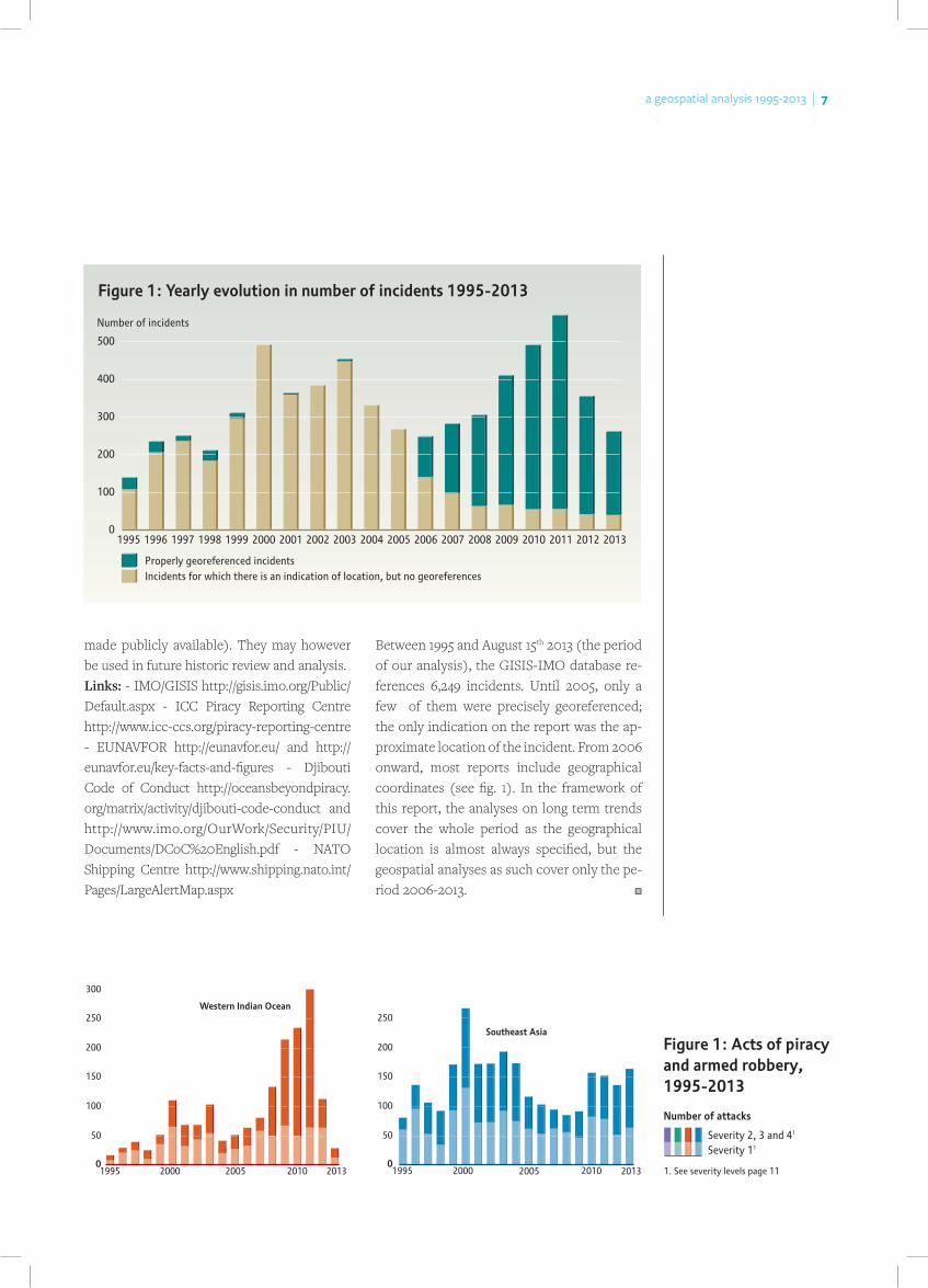
1995 1996 1997 1998 1999 2000 2001 2002 2003 2004 2005 2006 2007 2008 2009 2010 2011 2012 20130
100
200
300
400
500
Properly georeferenced incidentsIncidents for which there is an indication of location, but no georeferences
Number of incidents
Figure 1: Yearly evolution in number of incidents 1995-2013
made publicly available). They may however be used in future historic review and analysis.Links: - IMO/GISIS http://gisis.imo.org/Public/Default.aspx - ICC Piracy Reporting Centre http://www.icc-ccs.org/piracy-reporting-centre - EUNAVFOR http://eunavfor.eu/ and http://eunavfor.eu/key-facts-and-figures - Djibouti Code of Conduct http://oceansbeyondpiracy.org/matrix/activity/djibouti-code-conduct and http://www.imo.org/OurWork/Security/PIU/Documents/DCoC%20English.pdf - NATO Shipping Centre http://www.shipping.nato.int/Pages/LargeAlertMap.aspx
Between 1995 and August 15th 2013 (the period of our analysis), the GISIS-IMO database re-ferences 6,249 incidents. Until 2005, only a few of them were precisely georeferenced; the only indication on the report was the ap-proximate location of the incident. From 2006 onward, most reports include geographical coordinates (see fig. 1). In the framework of this report, the analyses on long term trends cover the whole period as the geographical location is almost always specified, but the geospatial analyses as such cover only the pe-riod 2006-2013. O
8 | UNOSAT Global Report on Maritime Piracy8 | UNOSAT Global Report on Maritime Piracy8 | UNOSAT Global Report on Maritime Piracy
High density of maritime traffic
Secondary shipping routes
High level of piracy acts over a large area
High level of piracy acts in isolated locations
Incidents with threats, injuries or fatalities reported
Incidents with no threats or violence reported
NORTHAMERICA
SOUTHAMERICA
EUROPE
ASIA
AFRICA
SOUTHEASTASIA
SOMALIA
AtlanticOcean
IndianOceanPacific
Ocean
PacificOcean
Gulf ofGuinea
COLOMBIA
Caracas
GUYANABelem
ECUADOR
Lima
Conakry IVORYCOAST
NIGERIA
DRC
IRAQ
EGYPT
IRAN
INDIA
PAKISTAN
BANGLADESH
VIETNAM
INDONESIA
MALAYSIA
SINGAPOUR
PHILIPPINES
CHINA
Mediterranean Sea
RedSea
Bay ofBengal
VENEZUELA
BRAZILPERU
Freetown Somaliland Puntland
SIERRALEONE
GUINEA
0 1,000 2,000 kmScale at the Equator
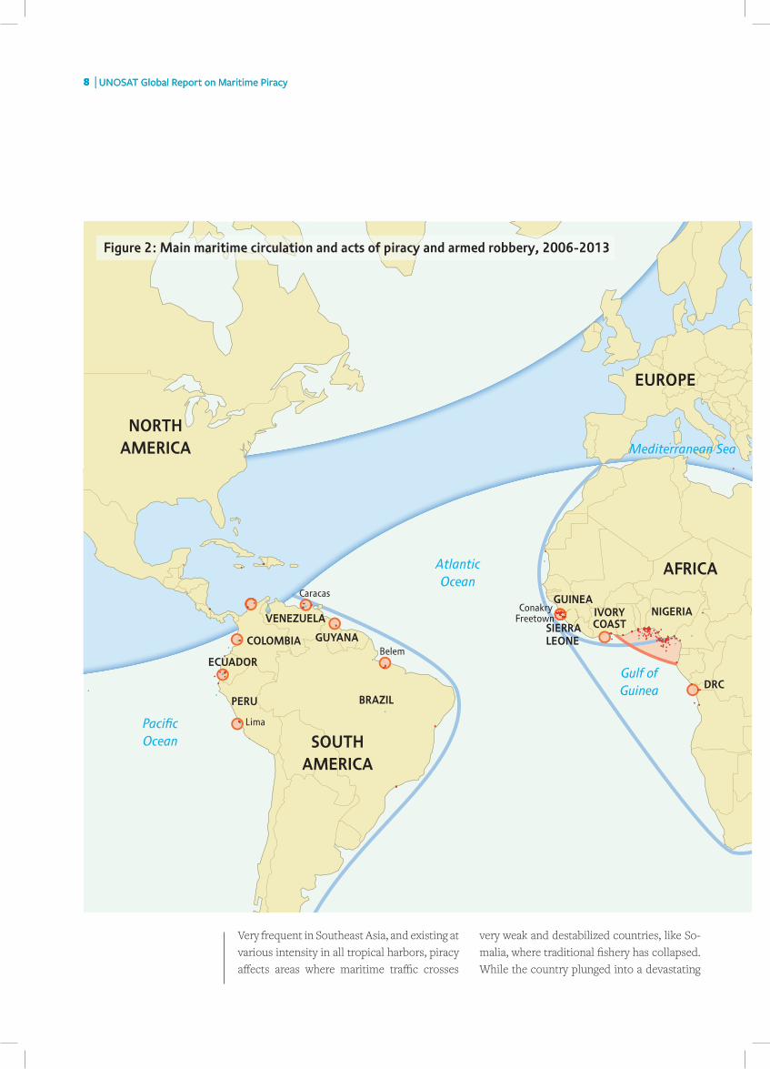
Figure 2: Main maritime circulation and acts of piracy and armed robbery, 2006-2013
Very frequent in Southeast Asia, and existing at various intensity in all tropical harbors, piracy affects areas where maritime traffic crosses
very weak and destabilized countries, like So-malia, where traditional fishery has collapsed. While the country plunged into a devastating
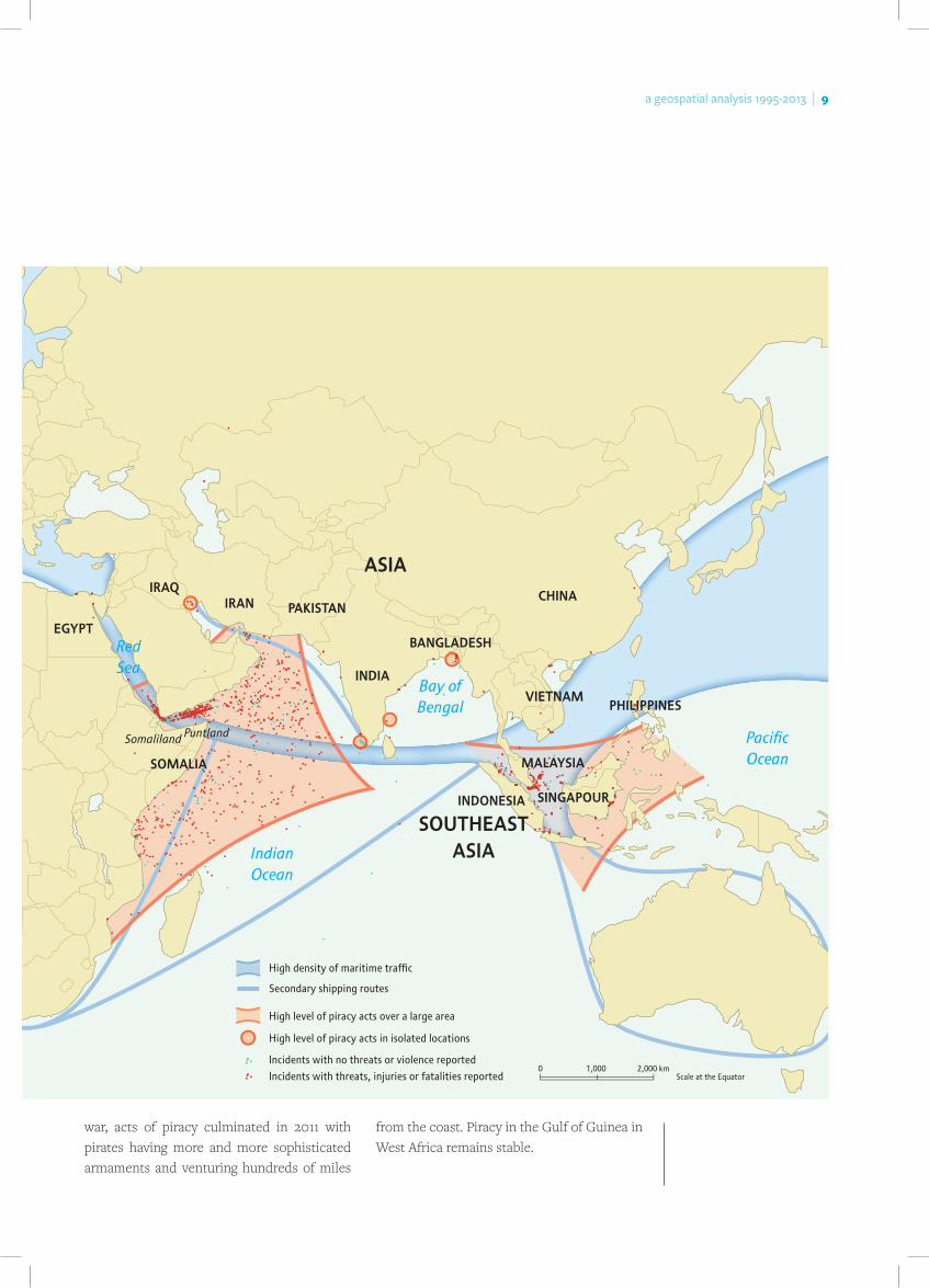
a geospatial analysis 1995-2013 | 9
High density of maritime traffic
Secondary shipping routes
High level of piracy acts over a large area
High level of piracy acts in isolated locations
Incidents with threats, injuries or fatalities reported
Incidents with no threats or violence reported
NORTHAMERICA
SOUTHAMERICA
EUROPE
ASIA
AFRICA
SOUTHEASTASIA
SOMALIA
AtlanticOcean
IndianOceanPacific
Ocean
PacificOcean
Gulf ofGuinea
COLOMBIA
Caracas
GUYANABelem
ECUADOR
Lima
Conakry IVORYCOAST
NIGERIA
DRC
IRAQ
EGYPT
IRAN
INDIA
PAKISTAN
BANGLADESH
VIETNAM
INDONESIA
MALAYSIA
SINGAPOUR
PHILIPPINES
CHINA
Mediterranean Sea
RedSea
Bay ofBengal
VENEZUELA
BRAZILPERU
Freetown Somaliland Puntland
SIERRALEONE
GUINEA
0 1,000 2,000 kmScale at the Equator
Figure 2: Main maritime circulation and acts of piracy and armed robbery, 2006-2013
war, acts of piracy culminated in 2011 with pirates having more and more sophisticated armaments and venturing hundreds of miles
from the coast. Piracy in the Gulf of Guinea in West Africa remains stable.
10 | UNOSAT Global Report on Maritime Piracy
Enriching piracy data
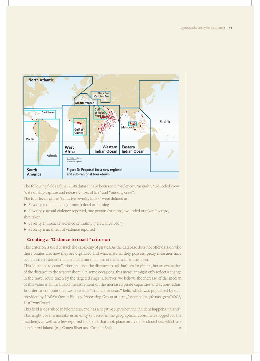
After an assessment of the data’s consistency, we proceeded to add several derivative fields, for statistical and GIS analysis. Most of these fields are just for convenience (coordinates in decimal representation, year, numerical representation of the text “number of pirates” field, and so on).Three of these added fields call for attention:F New geographic areas meant to improve consistencyF A tentative severity index, based on existing fields, allows for more precise analysisF A distance to coast criterion was created in order to evaluate the pirates’ capabilities
Defining new geographic areaFirst, as the IMO records directly what is reported by its sources, the geographic areas mentio-ned in the GISIS database are not always spelled the same way. When we mapped geopositioned incidents for each area, quite a lot of overlap was shown between them. Second, when a high concentration of incidents is identified, it can be worth splitting the data within a given region. A set of 8 regional boundaries, with a few subregions have been defined (see fig. 3).
2,421 incidents were geopositioned and 3,844 had no geographical references, however they were classified in a designated area. For example, a non-geopositioned event designed as having happened in the “Malacca Strait” was classified in the sub-region “Malacca” within the region “Eastern Indian Ocean”. This two-tier method allowed us to take some aggregate measures on the whole database. A consistency problem might have arisen, but this was carefully monitored; most incidents before 2006 were not geopositioned, while most events after 2006 were geopo-sitioned (see figure 2). Thus, any statistical analysis using precise coordinates should only take into account incidents after 2006.
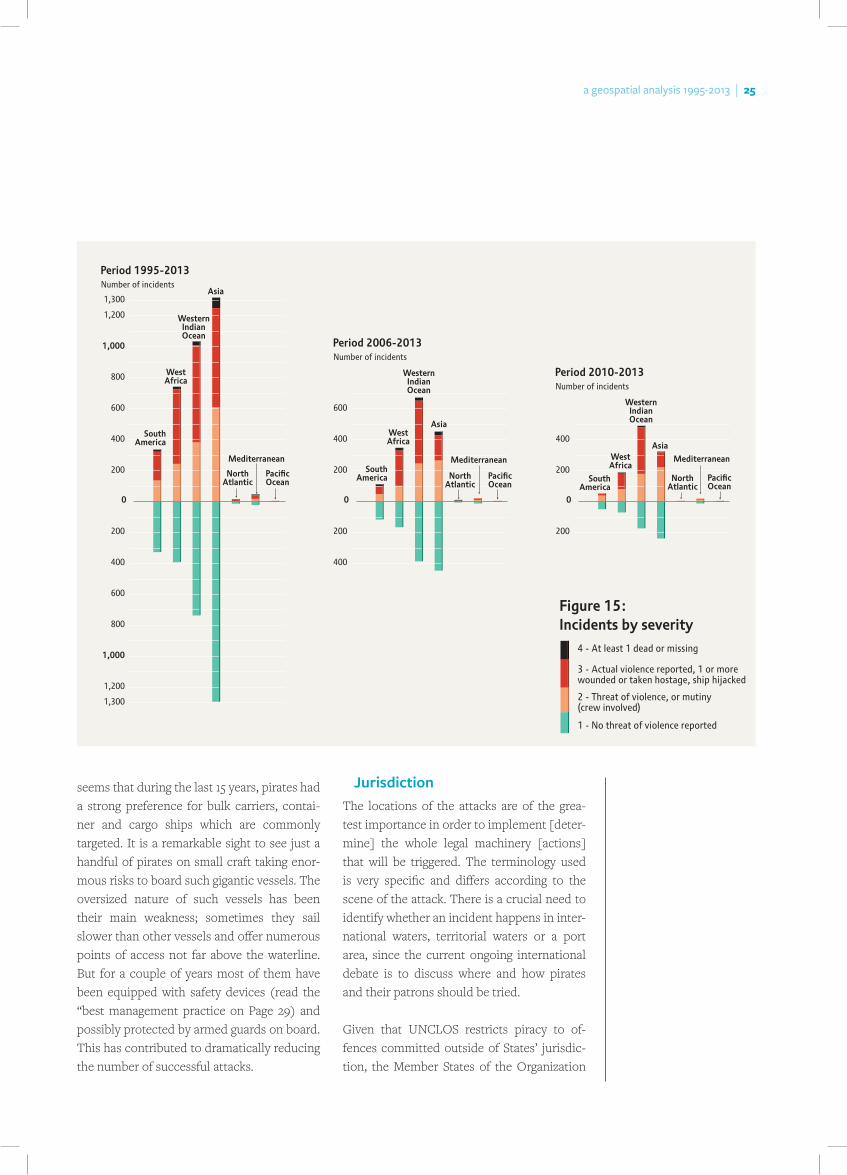
Defining a severity indexEven if ReCAAP-ISC already uses a three tier system for classifying the severity of attacks that are happening in Asia, there is no standard method for classifying the severity of acts of piracy and armed robbery. In accordance with the definition given in Article 101 of UNCLOS, which includes the concept of “depredation”, the GISIS database covers piracy and armed robbery, which also includes theft. With a statistical assessment of the severity of attacks, it was possible to make a distinction between very serious aggressions (e.g. resulting in the death of crew mem-bers), and a minor situation in which, according to the description given in the database, some rope got stolen on a ship at berth.
There were various ways to approach this issue, and we settled on the following proposal, which is to be considered as a “tentative severity index”. It is by no means a definitive way of classifying each individual incident, but a measure that can be useful for statistical aggregates.
The geographical analysis in this report is based on the Piracy and Armed Rob-bery database maintained by the International Maritime Organization’s Global Integrated Shipping Information System (GISIS) project. This database (as of August 15th 2013) describes 6,276 incidents, each representing a reported piracy or robbery event, from 1995 to mid-2013.
a geospatial analysis 1995-2013 | 11
The following fields of the GISIS dataset have been used: “violence”, “assault”, “wounded crew”, “date of ship capture and release”, “loss of life” and “missing crew”.The four levels of the “tentative severity index” were defined as:F Severity 4: one person (or more) dead or missingF Severity 3: actual violence reported, one person (or more) wounded or taken hostage, ship takenF Severity 2: threat of violence or mutiny (“crew involved”)F Severity 1: no threat of violence reported
Creating a “Distance to coast” criterionThis criterion is used to track the capability of pirates. As the database does not offer data on who these pirates are, how they are organized and what material they possess, proxy measures have been used to evaluate the distance from the place of the attacks to the coast.This “distance to coast” criterion is not the distance to safe harbors for pirates, but an evaluation of the distance to the nearest shore. On some occasions, this measure might only reflect a change in the travel route taken by the targeted ships. However, we believe the increase of the median of this value is an invaluable measurement on the increased pirate capacities and action-radius. In order to compute this, we created a “distance to coast” field, which was populated by data provided by NASA’s Ocean Biology Processing Group at http://oceancolor.gsfc.nasa.gov/DOCS/DistFromCoast/This field is described in kilometers, and has a negative sign when the incident happens “inland”. This might cover a mistake in an entry (an error in the geographical coordinates logged for the incident), as well as a few reported incidents that took place on rivers or closed sea, which are considered inland (e.g. Congo River and Caspian Sea). O
North Atlantic
SouthAmerica
Caribbean
Pacific
Atlantic
WestAfrica
Gulf of Guinea
Gulf of AdenRed Sea
Malacca
WesternIndian Ocean
Eastern Indian Ocean
Pacific
Black SeaCaspian Sea
Mediterranean
Figure 3: Proposal for a new regional and sub-regional breakdown
0 1,000 2,000 km
Scale at the Equator
12 | UNOSAT Global Report on Maritime Piracy
A brief history: 2000-2013Half pirate, half fisherman, the modern “sea bandit” is a player in a nameless war, that some observers describe as an asymmetric conflict or a clash between the “first and the fourth world”, as the lawer Larry Woodward defending a group of imprisoned pirates awaiting trial put it (Los Angeles Time, 13 June 2013). However, this does not oppose the fact that piracy and armed robbery against ships are criminal activities.
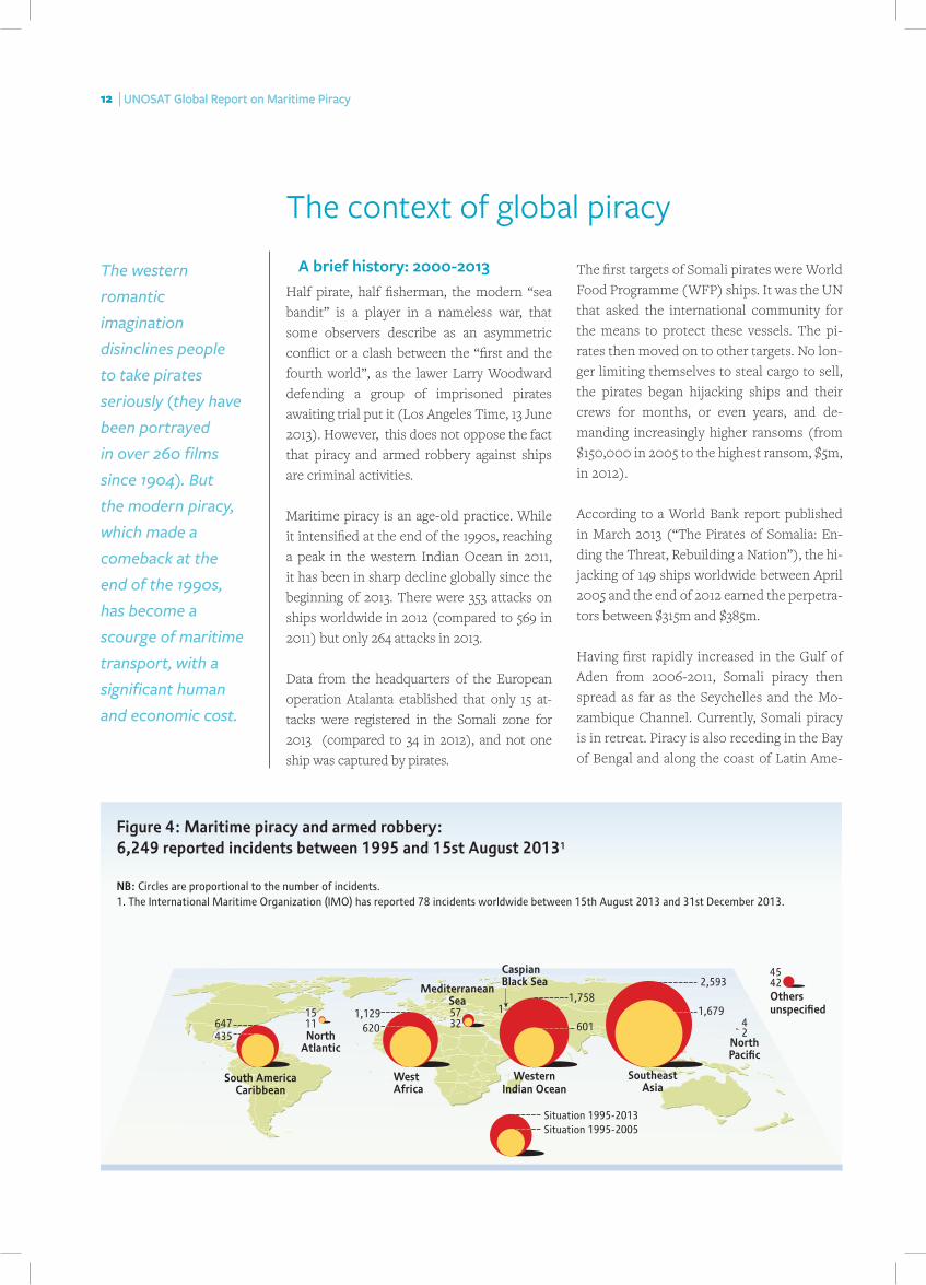
Maritime piracy is an age-old practice. While it intensified at the end of the 1990s, reaching a peak in the western Indian Ocean in 2011, it has been in sharp decline globally since the beginning of 2013. There were 353 attacks on ships worldwide in 2012 (compared to 569 in 2011) but only 264 attacks in 2013.
Data from the headquarters of the European operation Atalanta etablished that only 15 at-tacks were registered in the Somali zone for 2013 (compared to 34 in 2012), and not one ship was captured by pirates.
The first targets of Somali pirates were World Food Programme (WFP) ships. It was the UN that asked the international community for the means to protect these vessels. The pi-rates then moved on to other targets. No lon-ger limiting themselves to steal cargo to sell, the pirates began hijacking ships and their crews for months, or even years, and de-manding increasingly higher ransoms (from $150,000 in 2005 to the highest ransom, $5m, in 2012).
According to a World Bank report published in March 2013 (“The Pirates of Somalia: En-ding the Threat, Rebuilding a Nation”), the hi-jacking of 149 ships worldwide between April 2005 and the end of 2012 earned the perpetra-tors between $315m and $385m.
Having first rapidly increased in the Gulf of Aden from 2006-2011, Somali piracy then spread as far as the Seychelles and the Mo-zambique Channel. Currently, Somali piracy is in retreat. Piracy is also receding in the Bay of Bengal and along the coast of Latin Ame-
12 | UNOSAT Global Report on Maritime Piracy
The western romantic imagination disinclines people to take pirates seriously (they have been portrayed in over 260 films since 1904). But the modern piracy, which made a comeback at the end of the 1990s, has become a scourge of maritime transport, with a significant human and economic cost.
The context of global piracy
45
14
South AmericaCaribbean
NorthAtlantic
WestAfrica
WesternIndian Ocean
SoutheastAsia
NorthPacific
MediterraneanSea
CaspianBlack Sea
Others unspecified
435
42
2647
1,129620
1,758
601
2,593
1,6791115
3257
Situation 1995-2005Situation 1995-2013
NB: Circles are proportional to the number of incidents.1. The International Maritime Organization (IMO) has reported 78 incidents worldwide between 15th August 2013 and 31st December 2013.
Figure 4: Maritime piracy and armed robbery:6,249 reported incidents between 1995 and 15st August 20131
a geospatial analysis 1995-2013 | 13
rica, but not in the Gulf of Guinea and in the Caribbean Basin as well as South East Asia.
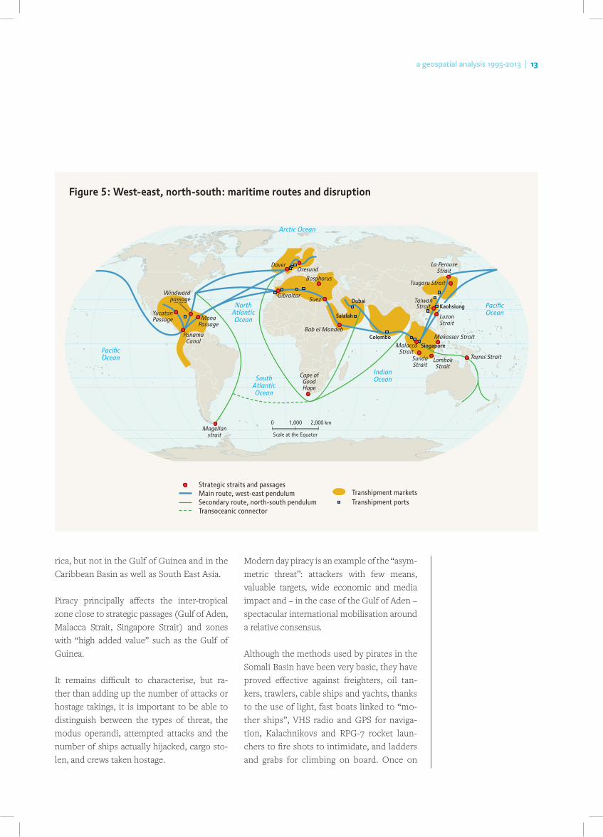
Piracy principally affects the inter-tropical zone close to strategic passages (Gulf of Aden, Malacca Strait, Singapore Strait) and zones with “high added value” such as the Gulf of Guinea.
It remains difficult to characterise, but ra-ther than adding up the number of attacks or hostage takings, it is important to be able to distinguish between the types of threat, the modus operandi, attempted attacks and the number of ships actually hijacked, cargo sto-len, and crews taken hostage.
Modern day piracy is an example of the “asym-metric threat”: attackers with few means, valuable targets, wide economic and media impact and – in the case of the Gulf of Aden – spectacular international mobilisation around a relative consensus.
Although the methods used by pirates in the Somali Basin have been very basic, they have proved effective against freighters, oil tan-kers, trawlers, cable ships and yachts, thanks to the use of light, fast boats linked to “mo-ther ships”, VHS radio and GPS for naviga-tion, Kalachnikovs and RPG-7 rocket laun-chers to fire shots to intimidate, and ladders and grabs for climbing on board. Once on
PanamaCanal
YucatanPassage
Windwardpassage
MonaPassage
Magellanstrait
Cape ofGoodHope
Bab el Mandeb
MalaccaStrait
Suez
Bosphorus
Gibraltar
OresundDover La Perouse
Strait
Tsugaru Strait
TaiwanStrait
LuzonStrait
SundaStrait
LombokStrait
Makassar Strait
Torres Strait
DubaiKaohsiung
Singapore
Colombo
Salalah
PacificOcean
SouthAtlanticOcean
NorthAtlanticOcean
IndianOcean
Arctic Ocean
PacificOcean
Strategic straits and passagesMain route, west-east pendulumSecondary route, north-south pendulumTransoceanic connector
Transhipment marketsTranshipment ports
Figure 5: West-east, north-south: maritime routes and disruption
0 1,000 2,000 km
Scale at the Equator
14 | UNOSAT Global Report on Maritime Piracy
board, the pirates can take the crew hostage, bring the ship to shore and demand ransoms.
The direct and indirect global cost“Kidnap and ransom (K&R)”
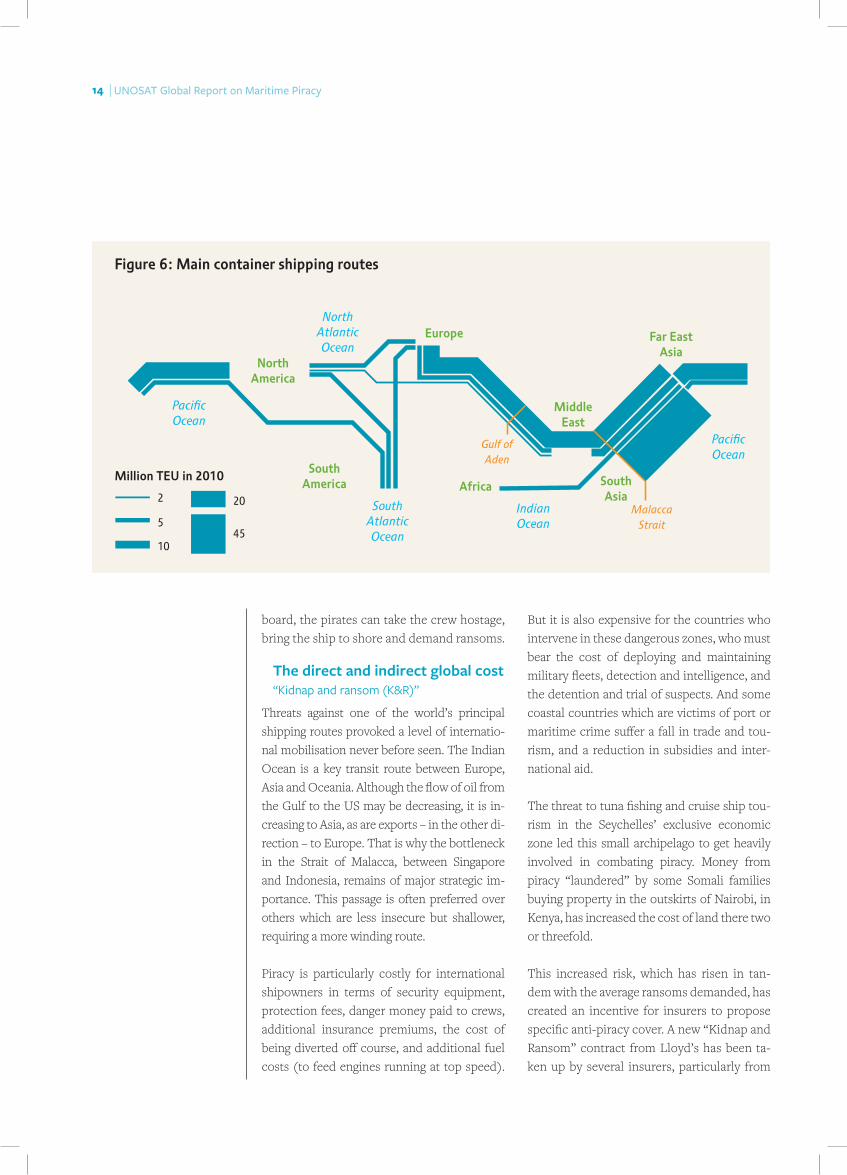
Threats against one of the world’s principal shipping routes provoked a level of internatio-nal mobilisation never before seen. The Indian Ocean is a key transit route between Europe, Asia and Oceania. Although the flow of oil from the Gulf to the US may be decreasing, it is in-creasing to Asia, as are exports – in the other di-rection – to Europe. That is why the bottleneck in the Strait of Malacca, between Singapore and Indonesia, remains of major strategic im-portance. This passage is often preferred over others which are less insecure but shallower, requiring a more winding route.
Piracy is particularly costly for international shipowners in terms of security equipment, protection fees, danger money paid to crews, additional insurance premiums, the cost of being diverted off course, and additional fuel costs (to feed engines running at top speed).
But it is also expensive for the countries who intervene in these dangerous zones, who must bear the cost of deploying and maintaining military fleets, detection and intelligence, and the detention and trial of suspects. And some coastal countries which are victims of port or maritime crime suffer a fall in trade and tou-rism, and a reduction in subsidies and inter-national aid.
The threat to tuna fishing and cruise ship tou-rism in the Seychelles’ exclusive economic zone led this small archipelago to get heavily involved in combating piracy. Money from piracy “laundered” by some Somali families buying property in the outskirts of Nairobi, in Kenya, has increased the cost of land there two or threefold.
This increased risk, which has risen in tan-dem with the average ransoms demanded, has created an incentive for insurers to propose specific anti-piracy cover. A new “Kidnap and Ransom” contract from Lloyd’s has been ta-ken up by several insurers, particularly from
NorthAmerica
SouthAmerica Africa
Europe
MiddleEast
SouthAsia
Far EastAsia
PacificOcean
IndianOcean
SouthAtlanticOcean
PacificOcean
NorthAtlanticOcean
Gulf ofAden
MalaccaStrait
Million TEU in 2010
2
5
10
20
45
Figure 6: Main container shipping routes
a geospatial analysis 1995-2013 | 15
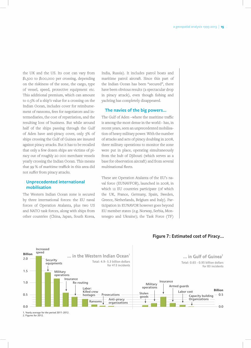
the UK and the US. Its cost can vary from $1,500 to $100,000 per crossing, depending on the riskiness of the zone, the cargo, type of vessel, speed, protective equipment etc. This additional premium, which can amount to 0.5% of a ship’s value for a crossing on the Indian Ocean, includes cover for reimburse-ment of ransoms, fees for negotiators and in-termediaries, the cost of repatriation, and the resulting loss of business. But while around half of the ships passing through the Gulf of Aden have anti-piracy cover, only 5% of ships crossing the Gulf of Guinea are insured against piracy attacks. But it has to be recalled that only a few dozen ships are victims of pi-racy out of roughly 20 000 merchant vessels yearly crossing the Indian Ocean. This means that 99 % of maritime traffick in this area did not suffer from piracy attacks.
Unprecedented international mobilisation
The Western Indian Ocean zone is secured by three international forces: the EU naval forces of Operation Atalanta, plus two US and NATO task forces, along with ships from other countries (China, Japan, South Korea,
India, Russia). It includes patrol boats and maritime patrol aircraft. Since this part of the Indian Ocean has been “secured”, there have been obvious results (a spectacular drop in piracy attack), even though fishing and yachting has completely disappeared.
The navies of the big powers…The Gulf of Aden –where the maritime traffic is among the most dense in the world – has, in recent years, seen an unprecedented mobilisa-tion of heavy military power. With the number of attacks and acts of piracy doubling in 2008, three military operations to monitor the zone were put in place, operating simultaneously from the hub of Djibouti (which serves as a base for observation aircraft) and from several multinational fleets.
These are Operation Atalanta of the EU’s na-val force (EUNAVFOR), launched in 2008, in which 12 EU countries participate (of which the UK, France, Germany, Spain, Sweden, Greece, Netherlands, Belgium and Italy). Par-ticipation in EUNAVOR however goes beyond EU member states (e.g. Norway, Serbia, Mon-tenegro and Ukraine); the Task Force (TF)
Anti-piracyorganizations
Prosecutions
Ransoms
Labor:Killed crewhostages
InsuranceRe-routing
Securityequipments
Increasedspeed
0.5
0.0
1.0
1.5
2.0
Insurance
Armed guardsMilitary
operations
Stolengoods
Labor costCapacity buildingOrganizations
Militaryoperations
0.5
0.0
Billion
Billion
Figure 7: Estimated cost of Piracy...
... in the Western Indian Ocean1 ... in Gulf of Guinea2
1. Yearly average for the period 2011-2012.2. Figures for 2012.
Total: 4.9- 5.3 billion dollarsfor 413 incidents
Total: 0.65 - 0.95 billion dollarsfor 83 incidents
508 “Ocean Shield” (sailing under NATO colours) which began in 2009 with 13 contri-buting countries (of which Canada, Denmark, Greece, Italy, Netherlands, Norway, Portugal, Spain, Turkey, the UK and US) and the Com-bined Task Force (CTF) 150/151 (dominated by the US, which originally had an “anti-ter-rorist” function but became “multi-mission”) with 14 participants, including Australia, Bahrain, Pakistan, South Korea, Singapore, Turkey, the UK and US.
Each of these forces has, on average, 3-6 warships (accompanied by support vessels), relieved every two to three months, with a re-volving command. In addition, forces under the authority of the Indian, Pakistani, Iranian, Japanese, Russian, Chinese or South Korean navies carry out specific missions in this sec-tor of the Horn of Africa where an average of 20-30 warships sailed in 2012 – a presence not seen before, except perhaps during the 1970-1980 wars in the Gulf, the Horn, and southern Africa.
This is the first time in history that such a large maritime coalition has existed, and with such extensive (if informal) means of infor-mation exchange and communication. Fleet commanders meet monthly at Shared Awa-reness and Deconfliction (Shade) meetings,
an initiative set up by CTF 151 in the first quar-ter of 2009. Following on from Operation Atalanta, the Maritime Security Centre-Horn of Africa was set up to centralize information on civil maritime activity. Ships are invited to use the International Recommended Transit Corridor (IRTC), 500 nautical miles long and 12 wide, closely guarded by naval forces who escort certain ships or surround convoys.
… facing the poor on the coastThese military fleets – experienced in patrol-ling the high seas, but not claiming to exert complete control over these vast areas, have forced pirate gangs to change modus ope-randi. The size and quality of the naval forces involved have increased the probability of being caught and punished. “We have before us a tactical success but a reversible one” said Rear Admiral Gualtiero Mattesi, Deputy Commander of Atalanta in September 2012 in an interview published on the information website B2 (www.bruxelles2.eu). “It is es-sential that pressure be maintained, or even increased, on the pirates and their ‘business model’. The strategic context, such as the si-tuation in Somalia that allows these pirates to act, has not yet fundamentally changed.”
“The motivations of piracy are still very much alive”, said Rear Admiral Bob Tarrant, Atalanta operation commander in July 2013 (interview with Bruxelles2, 28 July 2013). “Their commu-nities apparently have no alternative on how they live. We have a large enough control, but not all of the sea. […] If we give them the easy life at sea, I’m sure they will return to piracy.”
Atalanta’s mandate ends in December 2014, but discussions have started within the Euro-pean Union to possibly extend it. The Euro-pean parliament has supported Atalanta up to now, but has drawn two red lines: inter-vention on land, and the use of private mi-litary contractors. The EU has pursued two
16 | UNOSAT Global Report on Maritime Piracy
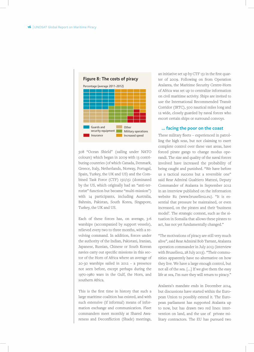
Figure 8: The costs of piracy
Guards and security equipment
Insurance Increased speedMilitary operationsOther
Percentage (average 2011-2012)
a geospatial analysis 1995-2013 | 17
PacificOcean
AtlanticOcean
IndianOcean
PacificOcean
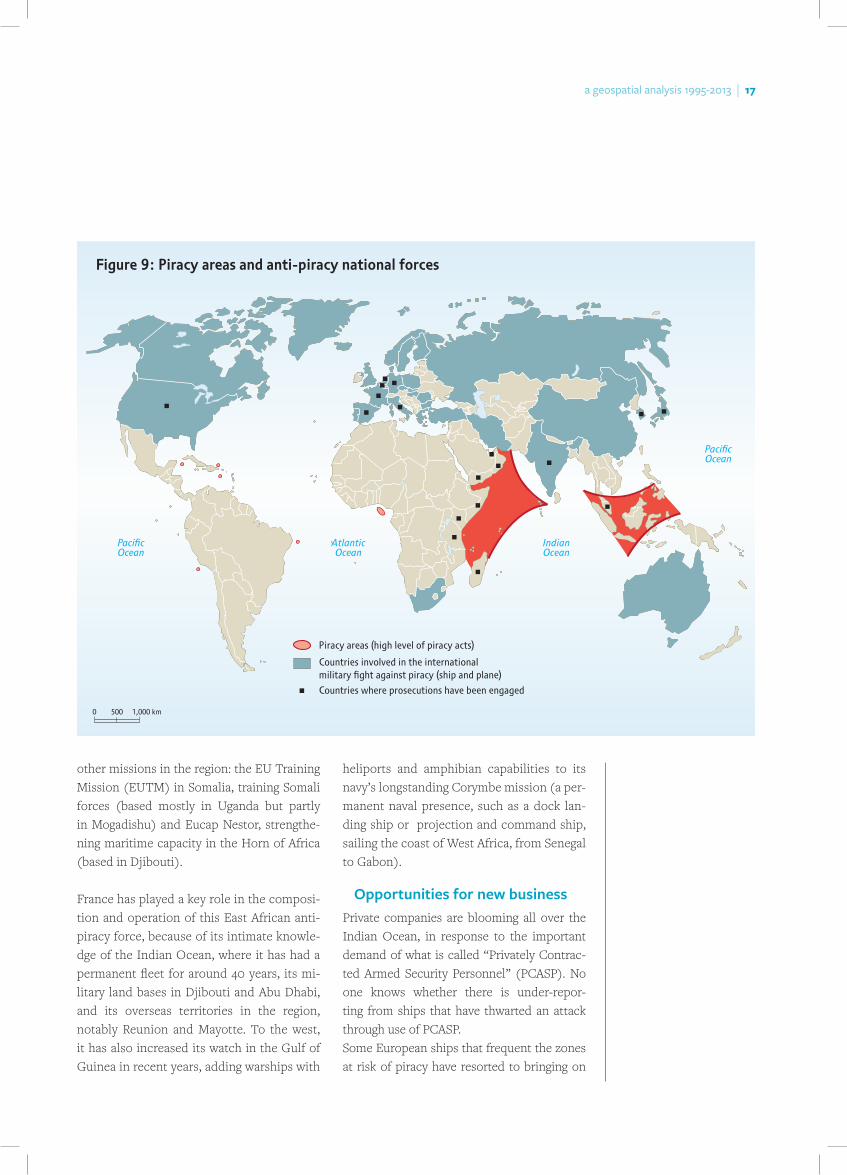
Figure 9: Piracy areas and anti-piracy national forces
Piracy areas (high level of piracy acts)
Countries involved in the international military fight against piracy (ship and plane)
Countries where prosecutions have been engaged
0 500 1,000 km
other missions in the region: the EU Training Mission (EUTM) in Somalia, training Somali forces (based mostly in Uganda but partly in Mogadishu) and Eucap Nestor, strengthe-ning maritime capacity in the Horn of Africa (based in Djibouti).
France has played a key role in the composi-tion and operation of this East African anti-piracy force, because of its intimate knowle-dge of the Indian Ocean, where it has had a permanent fleet for around 40 years, its mi-litary land bases in Djibouti and Abu Dhabi, and its overseas territories in the region, notably Reunion and Mayotte. To the west, it has also increased its watch in the Gulf of Guinea in recent years, adding warships with
heliports and amphibian capabilities to its navy’s longstanding Corymbe mission (a per-manent naval presence, such as a dock lan-ding ship or projection and command ship, sailing the coast of West Africa, from Senegal to Gabon).
Opportunities for new businessPrivate companies are blooming all over the Indian Ocean, in response to the important demand of what is called “Privately Contrac-ted Armed Security Personnel” (PCASP). No one knows whether there is under-repor-ting from ships that have thwarted an attack through use of PCASP. Some European ships that frequent the zones at risk of piracy have resorted to bringing on
18 | UNOSAT Global Report on Maritime Piracy
board private armed guards, regarded as more reassuring and effective. This practice is only officially authorized by some flags (the UK, Spain) and brings its own risks, such as legal uncertainty, the possibility of escalating vio-lence or of “blunders”, and the negative image of “mercenaries.
Several dozen private military contractors (PMCs), mostly British or American, have en-tered the maritime security market where the international legislation, in some cases, is still under debate. In the absence of internatio-nal legislation, these businesses comply with an International Code of Conduct for Private Security Service Providers (ICOC), a private initiative.
Some companies have ships that serve as floa-ting armouries, for their own crews or those of other companies, as explained by the NGO geopolcrim. info in a special issue published in July-August 2013.
In a national capacity, the French army offers (for a fee) the services of its commandos to travel on board the most vulnerable vessels, such as trawler-purse seiners, cable ships or WFP cargo ships. Discussion over the last 10 years on the status of these private military contractors (renamed “security and defense businesses”) resulted in december 2013 with the adoption of a legislation allowing armed guards on board vessels.
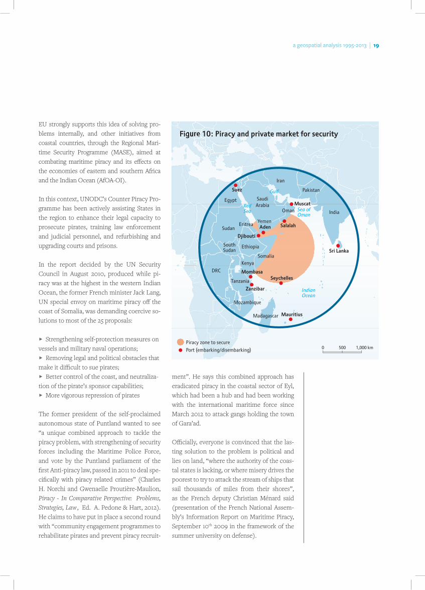
The Lowy Institute for International Policy, an independant think tank in Australia, estimates the “private counter piracy forces” in the In-dian Ocean at 2,700 armed guards, 18 floating armouries, 40 private armed patrol boats, over 160 private security companies, with 7 main ports of embarcation-disembarcation: Al Hu-daydah and Aden (Yemen), Salalah (Oman), Djibouti, Mombasa (Kenya), Galle (Sri Lan-ka), Singapore (see fig. 10).
On land or sea? A political or military solution?
Many Somali pirates are former coastguards looking for new opportunities. Some claim they were fishermen who had seen their re-sources dwindle as industrial fisheries plun-dered their waters (or polluted it by dum-ping waste from industrialised or emerging countries), although these claims are still dis-puted.
Some coastal countries, on the other hand, profit by making their infrastructure available in the fight against piracy, becoming military or judicial “hubs”. This is the case with Dji-bouti, Yemen, Mauritius and the Seychelles, which accommodate an air base with obser-vation aircraft and drones, special forces on board protection teams, private guards for Spanish trawler-purse seiners, a court room and a prison reserved for Somali suspects and prisoners, prefiguring a Regional Antipirate Prosecution Intelligence Centre (RAPIC) wi-thin the framework of the Indian Ocean Com-mission.
In Somalia, where pirate gangs had seven ships and 113 crew in March 2013, and 51 crew in September 2013, the new president, Hassan Sheikh Mohammed, has extended the hand of friendship. Through the intermediary of clan elders, he has offered an amnesty and professional retraining for young people who renounce piracy, setting up a kind of “employ-ment centre” for pirates. He has asked the in-ternational community to help him offer these poor young peasants and fishermen, attracted by the lucrative but dangerous prospects of pi-racy, “a different way to earn a living.”
Although the president in Mogadishu may not be in control of the whole country, and the initiative is controversial, it does reveal a growing desire to tackle problems at its root, for example living conditions in Somalia. The
a geospatial analysis 1995-2013 | 19
EU strongly supports this idea of solving pro-blems internally, and other initiatives from coastal countries, through the Regional Mari-time Security Programme (MASE), aimed at combating maritime piracy and its effects on the economies of eastern and southern Africa and the Indian Ocean (AfOA-OI).
In this context, UNODC’s Counter Piracy Pro-gramme has been actively assisting States in the region to enhance their legal capacity to prosecute pirates, training law enforcement and judicial personnel, and refurbishing and upgrading courts and prisons.
In the report decided by the UN Security Council in August 2010, produced while pi-racy was at the highest in the western Indian Ocean, the former French minister Jack Lang, UN special envoy on maritime piracy off the coast of Somalia, was demanding coercive so-lutions to most of the 25 proposals:
F Strengthening self-protection measures on vessels and military naval operations;F Removing legal and political obstacles that make it difficult to sue pirates;F Better control of the coast, and neutraliza-tion of the pirate’s sponsor capabilities;F More vigorous repression of pirates
The former president of the self-proclaimed autonomous state of Puntland wanted to see “a unique combined approach to tackle the piracy problem, with strengthening of security forces including the Maritime Police Force, and vote by the Puntland parliament of the first Anti-piracy law, passed in 2011 to deal spe-cifically with piracy related crimes” (Charles H. Norchi and Gwenaelle Proutière-Maulion, Piracy - In Comparative Perspective: Problems, Strategies, Law , Ed. A. Pedone & Hart, 2012). He claims to have put in place a second round with “community engagement programmes to rehabilitate pirates and prevent piracy recruit-
ment”. He says this combined approach has eradicated piracy in the coastal sector of Eyl, which had been a hub and had been working with the international maritime force since March 2012 to attack gangs holding the town of Gara’ad.
Officially, everyone is convinced that the las-ting solution to the problem is political and lies on land, “where the authority of the coas-tal states is lacking, or where misery drives the poorest to try to attack the stream of ships that sail thousands of miles from their shores”, as the French deputy Christian Ménard said (presentation of the French National Assem-bly’s Information Report on Maritime Piracy, September 10th 2009 in the framework of the summer university on defense).
Suez
Muscat
SalalahAden
Djibouti
Seychelles
Mauritius
Zanzibar
Mombasa
SaudiArabia
Yemen
Oman
Egypt
SudanEritrea
SouthSudan
Ethiopia
SomaliaKenya
Tanzania
DRC
Madagascar
Mozambique
Iran
Pakistan
India
Sri Lanka
IndianOcean
RedSea
Gulf
Sea ofOman
Piracy zone to secure
Port (embarking/disembarking)
Figure 10: Piracy and private market for security
0 500 1,000 km
However, for researcher Marc-Antoine Pe-rouse de Montclos of the Development Re-search Institute, an expert on both Nigeria and East Africa, the idea that poverty reduction will necessarily lead to piracy becoming less attractive is not proven. He points out that the Niger Delta is far from being the poorest re-gion in Nigeria, which itself is not the worst off country on the African coast; meanwhile there has been practically no piracy off the coasts of Angola or Mozambique. And the attacks on boats off Somalia have not necessarily been the work of poor sailors, since these opera-tions require a certain investment of capital, and the support of intermediaries to negotiate ransoms, and of international businessmen to receive the payments.
“Maritime piracy off the coast of East Africa cannot be defeated solely through military means”, was the view of the European Parlia-ment on 10 May 2012. But, according to Jean Guisnel and Viviane Mahler, authors of Pi-rates of Somalia, Grasset 2012: “All the players in this affair are aware that military action may have been useful in an emergency, no-tably in reducing the number of successful at-tacks, but that that is treating the symptoms, not the disease itself ”. The UN Monitoring group on Somalia and Eritrea “has mapped how piracy grew out of a kind of protection racket in response to illegal fishing and toxic waste dumping, and evolved into a money-driven, clan-based, transnational organized crime, constituting a threat to global ship-
20 | UNOSAT Global Report on Maritime Piracy
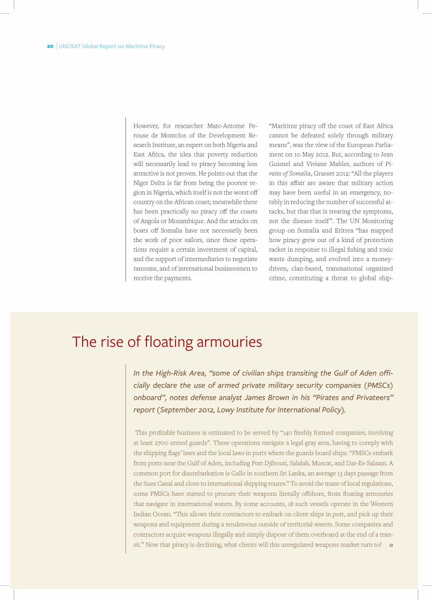
In the High-Risk Area, “some of civilian ships transiting the Gulf of Aden offi-cially declare the use of armed private military security companies (PMSCs) onboard”, notes defense analyst James Brown in his “Pirates and Privateers” report (September 2012, Lowy Institute for International Policy).
This profitable business is estimated to be served by “140 freshly formed companies, involving at least 2700 armed guards”. These operations navigate a legal gray area, having to comply with the shipping flags’ laws and the local laws in ports where the guards board ships. “PMSCs embark from ports near the Gulf of Aden, including Port Djibouti, Salalah, Muscat, and Dar-Es-Salaam. A common port for disembarkation is Galle in southern Sri Lanka, an average 13 days passage from the Suez Canal and close to international shipping routes.” To avoid the maze of local regulations, some PMSCs have started to procure their weapons literally offshore, from floating armouries that navigate in international waters. By some accounts, 18 such vessels operate in the Western Indian Ocean. “This allows their contractors to embark on client ships in port, and pick up their weapons and equipment during a rendezvous outside of territorial waters. Some companies and contractors acquire weapons illegally and simply dispose of them overboard at the end of a tran-sit.” Now that piracy is declining, what clients will this unregulated weapons market turn to? O
The rise of floating armouries
a geospatial analysis 1995-2013 | 21
ping” (letter to the Security Council, 12 July 2013). Fishermen and local villagers claim they acted as “coastguards” to try to dissuade foreign ships from fishing in Somali waters. The spokesman for the men who attacked the Ukrainian ship the Faina in 2008 claimed that piracy was fair compensation for foreign trawlers exploiting their fishing grounds. In fact, the illegal fishing of Somalia’s exclusive economic zone (EEZ, 200 nautical miles off its coast), which has not been policed since the fall of Siad Barre’s government in 1991 and the start of the civil war, has deprived Somalia of an estimated annual income of at least €100m.
In 2005, the Food and Agriculture Organi-sation estimated that there were 700 ships operating illegally off the Horn of Africa. The UN Monitoring Group on Somalia and Eri-trea letter refers to estimates by officials in the northern Somali region of Puntland: up to 180 illegal Iranian and 300 illegal Yemeni vessels are fishing Puntland waters, as well as a small number of Chinese, Korean and Eu-ropean-owned vessels (Jason Straziuso, AP, 25 July, 2013).
According to this report, the pirates’ “business model” has evolved: “The Somali pirate gangs in search of new revenue are now providing armed protection for ships illegally fishing So-mali waters. Erstwhile pirates should also be trafficking in arms, drugs and humans.” “To save their business,” says Karsten von Hoess-lin, analyst with the Danish consultancy Risk Intelligence, “the pirate leaders must continue to vary their tactics, to adapt to the counter-measures of the international naval forces and private security companies, as well as diver-sifying their investments into kat, smuggling cattle and human trafficking.” (“La nebuleuse pirate en Somalie”, Diplomatie N°56, May 2012). Risk Intelligence says it has identified more than 150 leaders, investors and negotia-
tors involved in Somali piracy in 2012. To il-lustrate the phenomenon of redeployment, it gives the example of Nigerians who had been responsible for attacks against private or go-vernment interests in the Niger Delta beco-ming advisers or security guards protecting merchant vessels.
Because of the absence of the state, Somalia’s 3,700km coastline has also become a dum-ping ground for chemical – even radioactive – waste, mostly from Europe, reports “Toxic Somalia: l’autre piraterie”, an investigation by Paul Moreira broadcast on Franco-Ger-man channel Arte, November 25th 2009. Some container ships carrying this waste were hit by the tsunami in 2004 and smashed against the shore, spilling their contents, risking contamination of the population as described in the “UNEP Post-Tsunami Reco-very Activities 2004-2007” and the “After the Tsunami Rapid Environmental Assessment” reports. But according to UN reports, there is no evidence of systematic dumping of waste off the Somali coast. O
22 | UNOSAT Global Report on Maritime Piracy
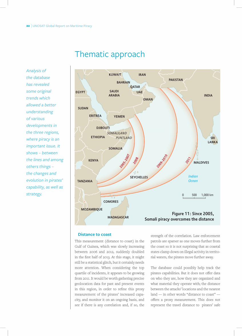
Analysis of the database has revealed some original trends which allowed a better understanding of various developments in the three regions, where piracy is an important issue. It shows – between the lines and among others things – the changes and evolution in pirates’ capability, as well as strategy.
Distance to coastThis measurement (distance to coast) in the Gulf of Guinea, which was slowly increasing between 2006 and 2012, suddenly doubled in the first half of 2013. At this stage, it might still be a statistical glitch, but it certainly needs more attention. When considering the top quartile of incidents, it appears to be growing from 2011. It would be worth gathering precise geolocation data for past and present events in this region, in order to refine this proxy measurement of the pirates’ increased capa-city, and monitor it on an ongoing basis, and see if there is any correlation and, if so, the
strength of the correlation. Law enforcement patrols are sparser as one moves further from the coast so it is not surprising that as coastal states clamp down on illegal activity in territo-rial waters, the pirates move further away.
The database could possibly help track the pirates capabilities. But it does not offer data on who they are, how they are organized and what material they operate with; the distance between the attacks’ locations and the nearest land — in other words “distance to coast” — offers a proxy measurement. This does not represent the travel distance to pirates’ safe
Thematic approach
SAUDIARABIA
YEMEN
OMAN
SOMALILANDPUNTLANDETHIOPIA
SOMALIA
SUDAN
KENYA
TANZANIA
EGYPTINDIA
PAKISTAN
IRAN
UAE
QATAR
MOZAMBIQUE
DJIBOUTI
ERITREA
MADAGASCAR
IndianOcean
2005-20
07
2008
2009-201
0
2011
SRILANKA
MALDIVES
SEYCHELLES
COMORES
KUWAIT
BAHRAIN
Figure 11: Since 2005,Somali piracy overcomes the distance
0 500 1,000 km

a geospatial analysis 1995-2013 | 23
harbors and on some occasions, this measure-ment might only reflect a change in the travel route taken by the targeted ships. However, an increase of the median of this value is an invaluable measurement of the pirates’ capa-bilities – at least in the areas in which a large part of incidents happen at sea.
In the western Indian Ocean, it clearly shows that the 2011 crisis, in the number of attacks, was correlated to the technical and operatio-nal capability of pirates to project themselves further away from the shores, and reach ships in the high seas. The distance to which they would go to hijack ships started growing in 2007, doubling again in 2008, then exploded in 2009, reaching a peak of between 350 and 400km. Between 2009 and 2011, 50% of all at-tacks happened at more that 350km from the shores. It is only in 2012 that pirates started to pull back.
This measure starts rising in 2006, two or three years before all other measures of the phenomenon (e.g the number of incidents) start climbing. It was thus an early predictor of the crisis in western Indian Ocean. Can one transpose this insight to Western Africa? If so,
one would have cause to worry, as this indi-cator, which was slowly increasing between 2006 and 2012, in the Gulf of Guinea, sudden-ly doubled in the first half of 2013.
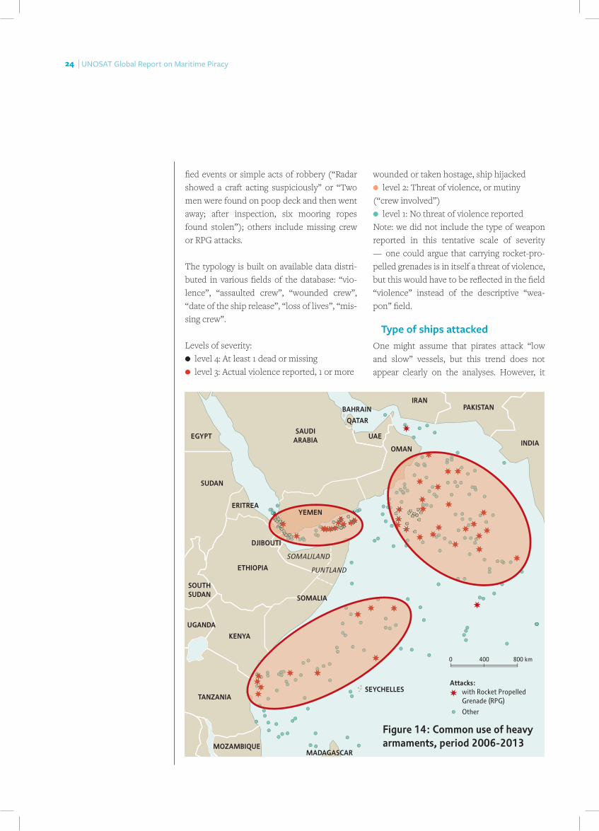
Types of weaponsIn September 2007, the diversion of the Faina, carrying tanks, rocket launchers and ammu-nition, may have initiated a radical change in Somali piracy. Since 2010, some pirates have started to use heavy weapons in their attacks on ships, often very far away off the coast of Somalia. Allegedly responsible for most of these attacks are the Hobyo-Harardhere network, led by Mohamed Abdi Hassan, aka Afweyne (“Big Mouth” in Somali) and Mr. Mo-hammed Aden (“Tiiceey”), a former governor of the Somali province of Himan and Heeb. The paradox is that Afweyne announced in January 2013 that he wanted to retire. By pro-mising to shoot a film on their life, Belgian investigators succeeded in arresting these two men on October 12th 2013. Their trial should highlight the nature of this “arms race”.
A proposed severity indexThe database contains reported incidents of very different nature: some are unquali-
0
50
100
150
200
250
300
350
400Kilometers
Kilometers
Figure 12:Median distance fromthe location of attacksto the coast
2007 2009 2011 20130
102007 2009 2011 2013
0
40
2007 2009 2011 2013
Kilometers
Gulf of Guinea Western Indian Ocean Southeast Asia - Malacca
0
10
5
15
20
25
30
35
40
45Number of incidents
Figure 13: RPG1 in the Western Indian Ocean
2012 201320112010
1. Rocket Propelled Grenade
24 | UNOSAT Global Report on Maritime Piracy
fied events or simple acts of robbery (“Radar showed a craft acting suspiciously” or “Two men were found on poop deck and then went away; after inspection, six mooring ropes found stolen”); others include missing crew or RPG attacks.
The typology is built on available data distri-buted in various fields of the database: “vio-lence”, “assaulted crew”, “wounded crew”, “date of the ship release”, “loss of lives”, “mis-sing crew”.
Levels of severity: level 4: At least 1 dead or missing level 3: Actual violence reported, 1 or more
wounded or taken hostage, ship hijacked level 2: Threat of violence, or mutiny
(“crew involved”) level 1: No threat of violence reported
Note: we did not include the type of weapon reported in this tentative scale of severity — one could argue that carrying rocket-pro-pelled grenades is in itself a threat of violence, but this would have to be reflected in the field “violence” instead of the descriptive “wea-pon” field.
Type of ships attackedOne might assume that pirates attack “low and slow” vessels, but this trend does not appear clearly on the analyses. However, it
SAUDIARABIA
YEMEN
OMAN
SOMALILAND
PUNTLANDETHIOPIA
SOMALIA
SEYCHELLES
MADAGASCAR
SUDAN
SOUTHSUDAN
KENYA
UGANDA
TANZANIA
EGYPTINDIA
PAKISTANIRAN
UAE
QATAR
MOZAMBIQUE
DJIBOUTI
ERITREA
BAHRAIN
Attacks:with Rocket Propelled Grenade (RPG)
Other
Figure 14: Common use of heavyarmaments, period 2006-2013
0 400 800 km
a geospatial analysis 1995-2013 | 25
seems that during the last 15 years, pirates had a strong preference for bulk carriers, contai-ner and cargo ships which are commonly targeted. It is a remarkable sight to see just a handful of pirates on small craft taking enor-mous risks to board such gigantic vessels. The oversized nature of such vessels has been their main weakness; sometimes they sail slower than other vessels and offer numerous points of access not far above the waterline. But for a couple of years most of them have been equipped with safety devices (read the “best management practice on Page 29) and possibly protected by armed guards on board. This has contributed to dramatically reducing the number of successful attacks.
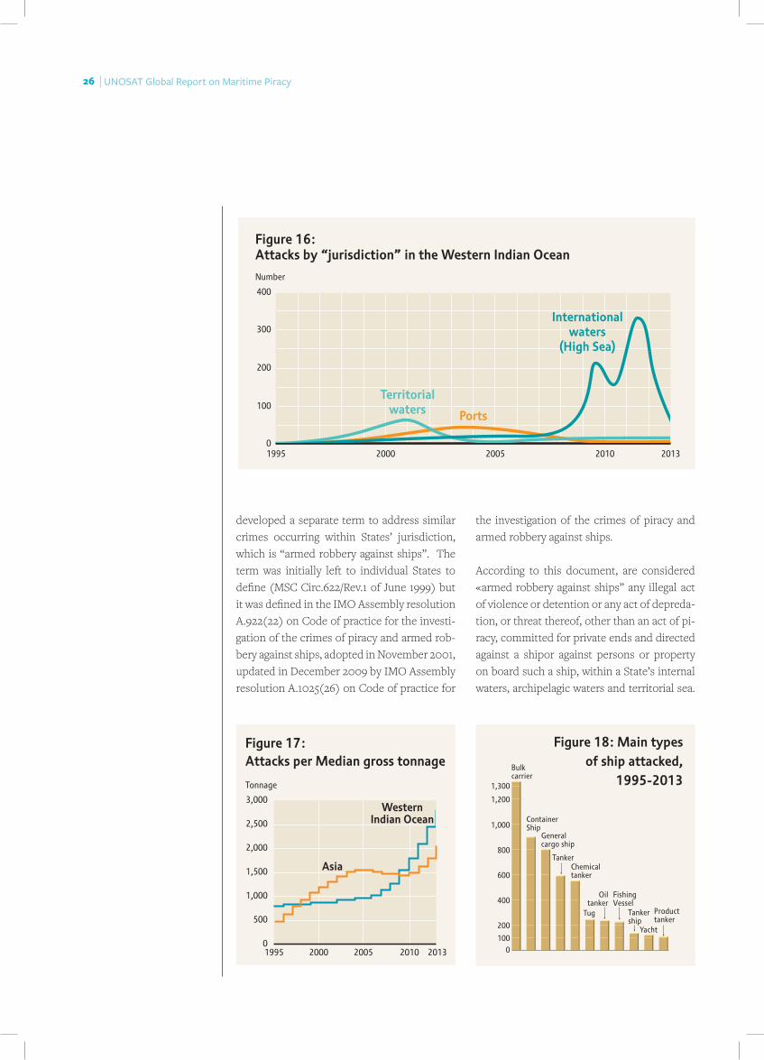
JurisdictionThe locations of the attacks are of the grea-test importance in order to implement [deter-mine] the whole legal machinery [actions] that will be triggered. The terminology used is very specific and differs according to the scene of the attack. There is a crucial need to identify whether an incident happens in inter-national waters, territorial waters or a port area, since the current ongoing international debate is to discuss where and how pirates and their patrons should be tried.
Given that UNCLOS restricts piracy to of-fences committed outside of States’ jurisdic-tion, the Member States of the Organization
0
200
200
400
600
800
1,000
1,200
1,300
400
600
800
1,000
1,200
1,300
Period 1995-2013
SouthAmerica
WestAfrica
WesternIndianOcean
Asia
NorthAtlantic
Mediterranean
PacificOcean
Number of incidents
Incidents by severityFigure 15:
0
200
200
400
400
600
Period 2006-2013
SouthAmerica
WestAfrica
WesternIndianOcean
Asia
NorthAtlantic
Mediterranean
PacificOcean
Number of incidents
0
200
200
400
Period 2010-2013
SouthAmerica
WestAfrica
WesternIndianOcean
Asia
NorthAtlantic
Mediterranean
PacificOcean
Number of incidents
2 - Threat of violence, or mutiny (crew involved)
4 - At least 1 dead or missing
3 - Actual violence reported, 1 or more wounded or taken hostage, ship hijacked
1 - No threat of violence reported
26 | UNOSAT Global Report on Maritime Piracy
developed a separate term to address similar crimes occurring within States’ jurisdiction, which is “armed robbery against ships”. The term was initially left to individual States to define (MSC Circ.622/Rev.1 of June 1999) but it was defined in the IMO Assembly resolution A.922(22) on Code of practice for the investi-gation of the crimes of piracy and armed rob-bery against ships, adopted in November 2001, updated in December 2009 by IMO Assembly resolution A.1025(26) on Code of practice for
the investigation of the crimes of piracy and armed robbery against ships.
According to this document, are considered «armed robbery against ships” any illegal act of violence or detention or any act of depreda-tion, or threat thereof, other than an act of pi-racy, committed for private ends and directed against a shipor against persons or property on board such a ship, within a State’s internal waters, archipelagic waters and territorial sea.
20001995 2005 2010 20130
500
1,000
1,500
2,000
2,500
3,000
Figure 17:Attacks per Median gross tonnage
Tonnage
WesternIndian Ocean
Asia
0
200
400
600
800
1,000
1,200
1,300
Producttanker
Yacht
Tankership
FishingVessel
Oiltanker
Tug
Chemicaltanker
Tanker
Generalcargo ship
ContainerShip
Bulkcarrier
100
Figure 18: Main typesof ship attacked,
1995-2013
1995 2000 2005 2010 20130
100
200
300
400
Figure 16:Attacks by “jurisdiction” in the Western Indian Ocean
Number
Ports
Internationalwaters
(High Sea)
Territorialwaters
a geospatial analysis 1995-2013 | 27
AFRICA
EUROPE
MIDDLEEAST
ASIA
OCEANIA
IndianOceanSouth
AtlanticOcean
NorthAtlanticOcean
PacificOcean
Gulf ofGuinea
MalaccaStrait
Gulf ofAden
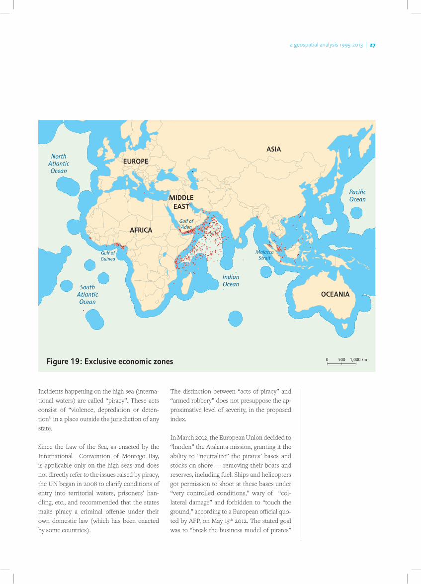
Figure 19: Exclusive economic zones 0 1,000 km500
Incidents happening on the high sea (interna-tional waters) are called “piracy”. These acts consist of “violence, depredation or deten-tion” in a place outside the jurisdiction of any state.
Since the Law of the Sea, as enacted by the International Convention of Montego Bay, is applicable only on the high seas and does not directly refer to the issues raised by piracy, the UN began in 2008 to clarify conditions of entry into territorial waters, prisoners’ han-dling, etc., and recommended that the states make piracy a criminal offense under their own domestic law (which has been enacted by some countries).
The distinction between “acts of piracy” and “armed robbery” does not presuppose the ap-proximative level of severity, in the proposed index.
In March 2012, the European Union decided to “harden” the Atalanta mission, granting it the ability to “neutralize” the pirates’ bases and stocks on shore — removing their boats and reserves, including fuel. Ships and helicopters got permission to shoot at these bases under “very controlled conditions,” wary of “col-lateral damage” and forbidden to “touch the ground,” according to a European official quo-ted by AFP, on May 15th 2012. The stated goal was to “break the business model of pirates”
at all levels, from preparations for attacks to the laundering of profits. Several pirate bases on the coast of Puntland had already been destroyed in May 2008, forcing the pirate lea-ders to operate from inland or abandon, at least temporarily, this type of activity.
Besides protecting merchant ships, Atalanta has led to the arrest of 117 suspected pirates and the dismantling of 27 groups of pirates in 2011. It was estimated (in May 2012) that, overall, 2,500 suspects had been arrested since the re-surgence of piracy in the Indian Ocean in 2008, 850 brought to justice, and 350 convicted.
In March 2012 the EU refined the terms of ar-rest and detention of suspects, providing a le-gal basis for transfers to Puntland, Somaliland, Mauritius or the Seychelles (Kenya showed it-self to be reluctant). In mid-2012, a thousand Somalis were jailed worldwide – including in the United States and France – mostly for acts of piracy.
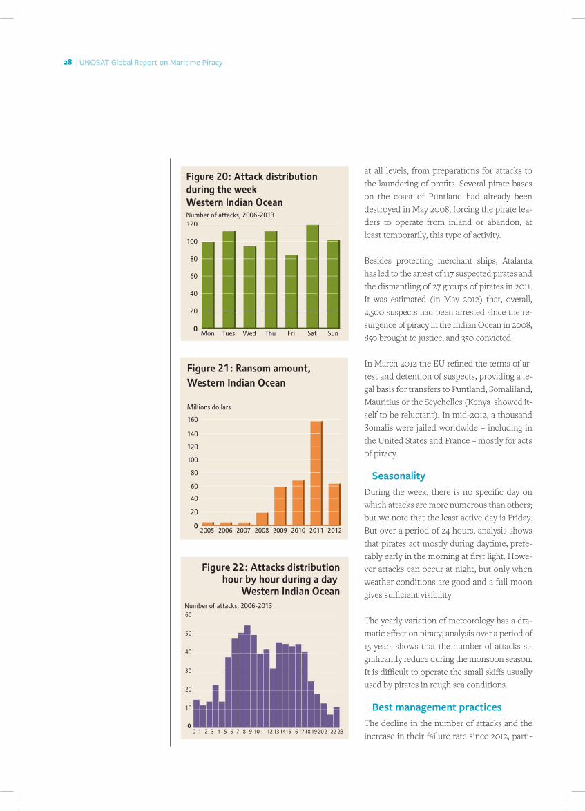
SeasonalityDuring the week, there is no specific day on which attacks are more numerous than others; but we note that the least active day is Friday. But over a period of 24 hours, analysis shows that pirates act mostly during daytime, prefe-rably early in the morning at first light. Howe-ver attacks can occur at night, but only when weather conditions are good and a full moon gives sufficient visibility.
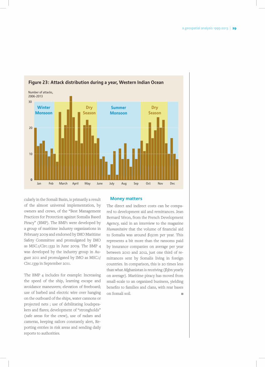
The yearly variation of meteorology has a dra-matic effect on piracy; analysis over a period of 15 years shows that the number of attacks si-gnificantly reduce during the monsoon season. It is difficult to operate the small skiffs usually used by pirates in rough sea conditions.
Best management practicesThe decline in the number of attacks and the increase in their failure rate since 2012, parti-
28 | UNOSAT Global Report on Maritime Piracy
0
120
100
80
60
40
20
Figure 20: Attack distribution during the week Western Indian OceanNumber of attacks, 2006-2013
Mon Tues Wed Thu Fri Sat Sun
0
160
100
120
140
80
60
40
20
Figure 21: Ransom amount,Western Indian Ocean
Millions dollars
2005 2006 2007 2008 2009 2010 2011 2012
0
20
10
30
40
50
60Number of attacks, 2006-2013
Figure 22: Attacks distributionhour by hour during a day
Western Indian Ocean
10 2 3 4 5 6 7 8 9 1011 12 131415 16171819 20 2122 23
a geospatial analysis 1995-2013 | 29
0
10
20
30
Figure 23: Attack distribution during a year, Western Indian Ocean
Number of attacks, 2006-2013
Jan Feb March April May June July Aug Sep Oct Nov Dec
SummerMonsoon
WinterMonsoon
DrySeason
DrySeason
cularly in the Somali Basin, is primarily a result of the almost universal implementation, by owners and crews, of the “Best Management Practices for Protection against Somalia Based Piracy” (BMP). The BMP1 were developed by a group of maritime industry organizations in February 2009 and endorsed by IMO Maritime Safety Committee and promulgated by IMO as MSC.1/Circ.1332 in June 2009. The BMP 4 was developed by the industry group in Au-gust 2011 and promulgated by IMO as MSC.1/Circ.1339 in September 2011.
The BMP 4 includes for example: Increasing the speed of the ship, learning escape and avoidance maneuvers; elevation of freeboard; use of barbed and electric wire over hanging on the outboard of the ships, water cannons or projected nets ; use of debilitating loudspea-kers and flares; development of “strongholds” (safe areas for the crew), use of radars and cameras, keeping sailors constantly alert, Re-porting entries in risk areas and sending daily reports to authorities.
Money mattersThe direct and indirect costs can be compa-red to development aid and remittances. Jean Bernard Véron, from the French Development Agency, said in an interview to the magazine Humanitaire that the volume of financial aid to Somalia was around $150m per year. This represents a bit more than the ransoms paid by insurance companies on average per year between 2010 and 2012, just one third of re-mittances sent by Somalis living in foreign countries. In comparison, this is 20 times less than what Afghanistan is receiving ($3bn yearly on average). Maritime piracy has moved from small-scale to an organized business, yielding benefits to families and clans, with rear bases on Somali soil. O
30 | UNOSAT Global Report on Maritime Piracy
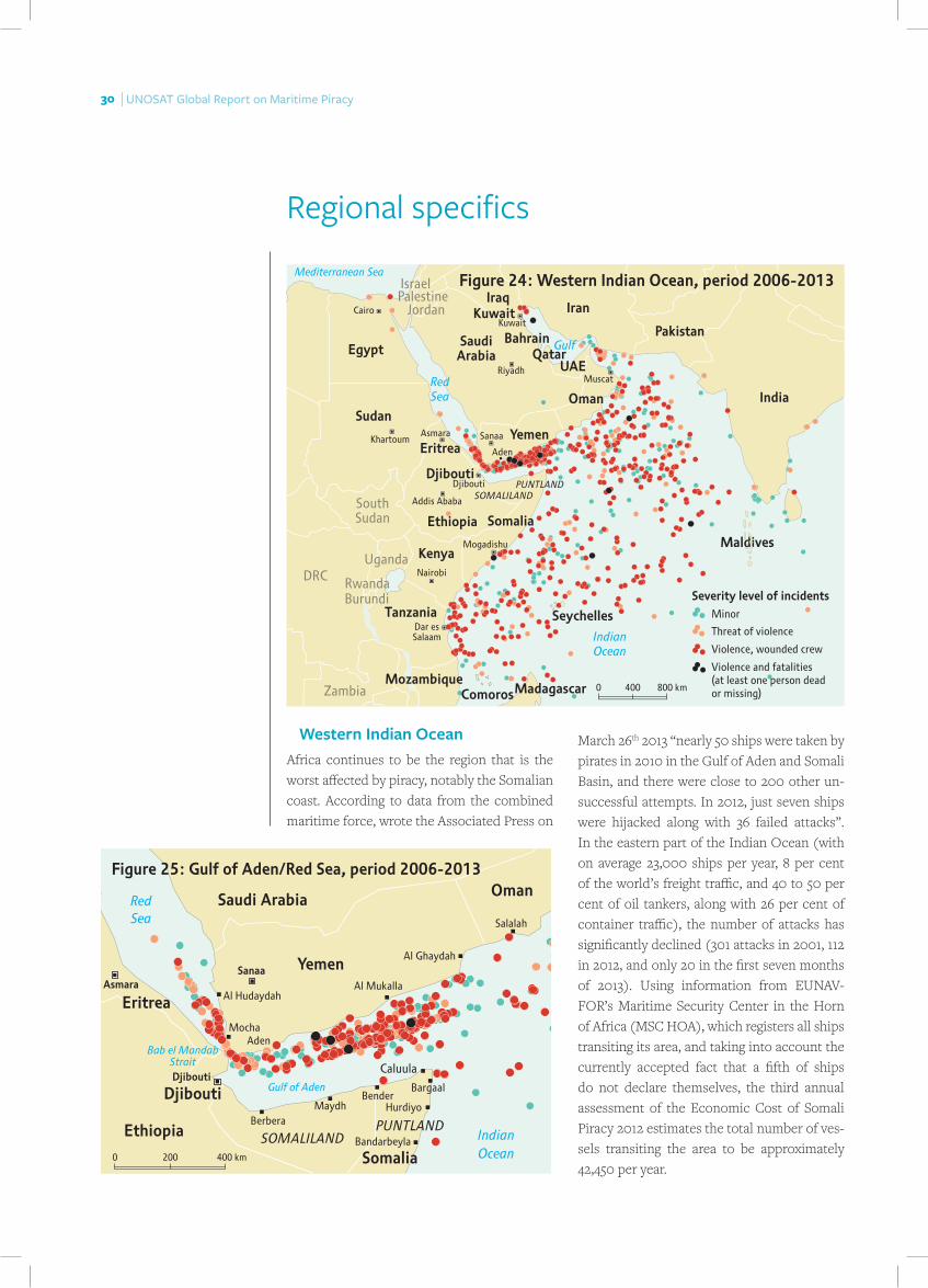
Western Indian OceanAfrica continues to be the region that is the worst affected by piracy, notably the Somalian coast. According to data from the combined maritime force, wrote the Associated Press on
March 26th 2013 “nearly 50 ships were taken by pirates in 2010 in the Gulf of Aden and Somali Basin, and there were close to 200 other un-successful attempts. In 2012, just seven ships were hijacked along with 36 failed attacks”. In the eastern part of the Indian Ocean (with on average 23,000 ships per year, 8 per cent of the world’s freight traffic, and 40 to 50 per cent of oil tankers, along with 26 per cent of container traffic), the number of attacks has significantly declined (301 attacks in 2001, 112 in 2012, and only 20 in the first seven months of 2013). Using information from EUNAV-FOR’s Maritime Security Center in the Horn of Africa (MSC HOA), which registers all ships transiting its area, and taking into account the currently accepted fact that a fifth of ships do not declare themselves, the third annual assessment of the Economic Cost of Somali Piracy 2012 estimates the total number of ves-sels transiting the area to be approximately 42,450 per year.
Regional specifics
Somalia
IndianOcean
Gulf
India
Mediterranean Sea
RedSea
Pakistan
IranIraq
Yemen
Oman
SaudiArabia
Ethiopia
Kenya
Sudan
Egypt
Jordan
IsraelPalestine
SouthSudan
Eritrea
DjiboutiDjibouti PUNTLAND
SOMALILAND
RiyadhMuscat
Sanaa
Aden
Cairo
KhartoumAsmara
Kuwait
Dar esSalaam
Addis Ababa
Nairobi
Mogadishu
DRCUganda
RwandaBurundi
Tanzania
ZambiaMozambique
Madagascar
UAEQatar
Kuwait
Maldives
Seychelles
Comoros
Bahrain
zazzozozoz
uuuu
Threat of violence
Minor
Violence, wounded crew
Violence and fatalities (at least one person dead or missing)
Severity level of incidents
Figure 24: Western Indian Ocean, period 2006-2013
0 800 km400
Somalia
PUNTLANDSOMALILAND Indian
Ocean
RedSea
Yemen
OmanSaudi Arabia
Ethiopia
Djibouti
Eritrea
Sanaa
Aden
Al Mukalla
Mocha
Al Hudaydah
Al Ghaydah
Salalah
Djibouti
BerberaMaydh
Bender
Caluula
Bargaal
Hurdiyo
Asmara
Bandarbeyla
Figure 25: Gulf of Aden/Red Sea, period 2006-2013
Gulf of Aden
Bab el MandabStrait
0 200 400 km
a geospatial analysis 1995-2013 | 31
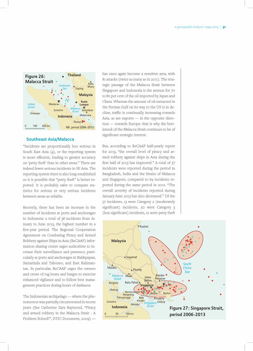
Southeast Asia/Malacca“Incidents are proportionally less serious in South East Asia (4), or the reporting system is more efficient, leading to greater accuracy on ‘petty theft’ than in other areas.” There are indeed fewer serious incidents in SE Asia. The reporting system there is also long-established so it is possible that “petty theft” is better re-ported. It is probably safer to compare sta-tistics for serious or very serious incidents between areas as reliable.
Recently, there has been an increase in the number of incidents at ports and anchorages in Indonesia: a total of 38 incidents from Ja-nuary to June 2013, the highest number in a five-year period. The Regional Cooperation Agreement on Combating Piracy and Armed Robbery against Ships in Asia (ReCAAP) infor-mation sharing centre urges authorities to in-crease their surveillance and presence, parti-cularly at ports and anchorages in Balikpapan, Samarinda and Taboneo, and East Kaliman-tan. In particular, ReCAAP urges the owners and crews of tug boats and barges to exercise enhanced vigilance and to follow best mana-gement practices during hours of darkness.
The Indonesian archipelago — where the phe-nomenon was partially circumvented in recent years (See Catherine Zara Raymond, “Piracy and armed robbery in the Malacca Strait - A Problem Solved?”, DTIC Document, 2009) —
has once again become a sensitive area, with 81 attacks (twice as many as in 2011). The stra-tegic passage of the Malacca Strait between Singapore and Indonesia is the avenue for 70 to 80 per cent of the oil imported by Japan and China. Whereas the amount of oil extracted in the Persian Gulf on its way to the US is in de-cline, traffic is continually increasing towards Asia, as are exports — in the opposite direc-tion — towards Europe: that is why the bott-leneck of the Malacca Strait continues to be of significant strategic interest.
But, according to ReCAAP half-yearly report for 2013, “the overall level of piracy and ar-med robbery against ships in Asia during the first half of 2013 has improved.” A total of 57 incidents were reported during the period in Bangladesh, India and the Straits of Malacca and Singapore, compared to 64 incidents re-ported during the same period in 2012. “The overall severity of incidents reported during January-June 2013 has also decreased.” Of the 57 incidents, 13 were Category 2 (moderately significant) incidents, 20 were Category 3 (less significant) incidents, 21 were petty theft
Kuatan
Batu Pahat
Malaka
Muar
Segamat
Kluang
JohorBahru
Sumatra
BandarPenawar
Singapore
SouthChinaSea
MalaccaStrait
SingaporeStrait
Malaysia
Indonesia
Rangsang
Kundur
Bengalis
Pedang
Tebingtinggi
Mendol
BintanBatam
GalangRampang
Karimunbesar
Bela
Figure 27: Singapore Strait,period 2006-20130 50 100 km
Seremban
Malacca
Taiping
Medan
KotaBharu
KualaLumpur
AndamanSea
IndianOcean Malacca
Strait
Malaysia
Thailand
Indonesia
Dumai
Figure 26: Malacca Strait
NB: period 2006-2013.
SumatraSimeulue
0 100 200 km
32 | UNOSAT Global Report on Maritime Piracy
incidents and three were attempted incidents; there was no Category 1 very significant inci-dent reported during January-June 2013.
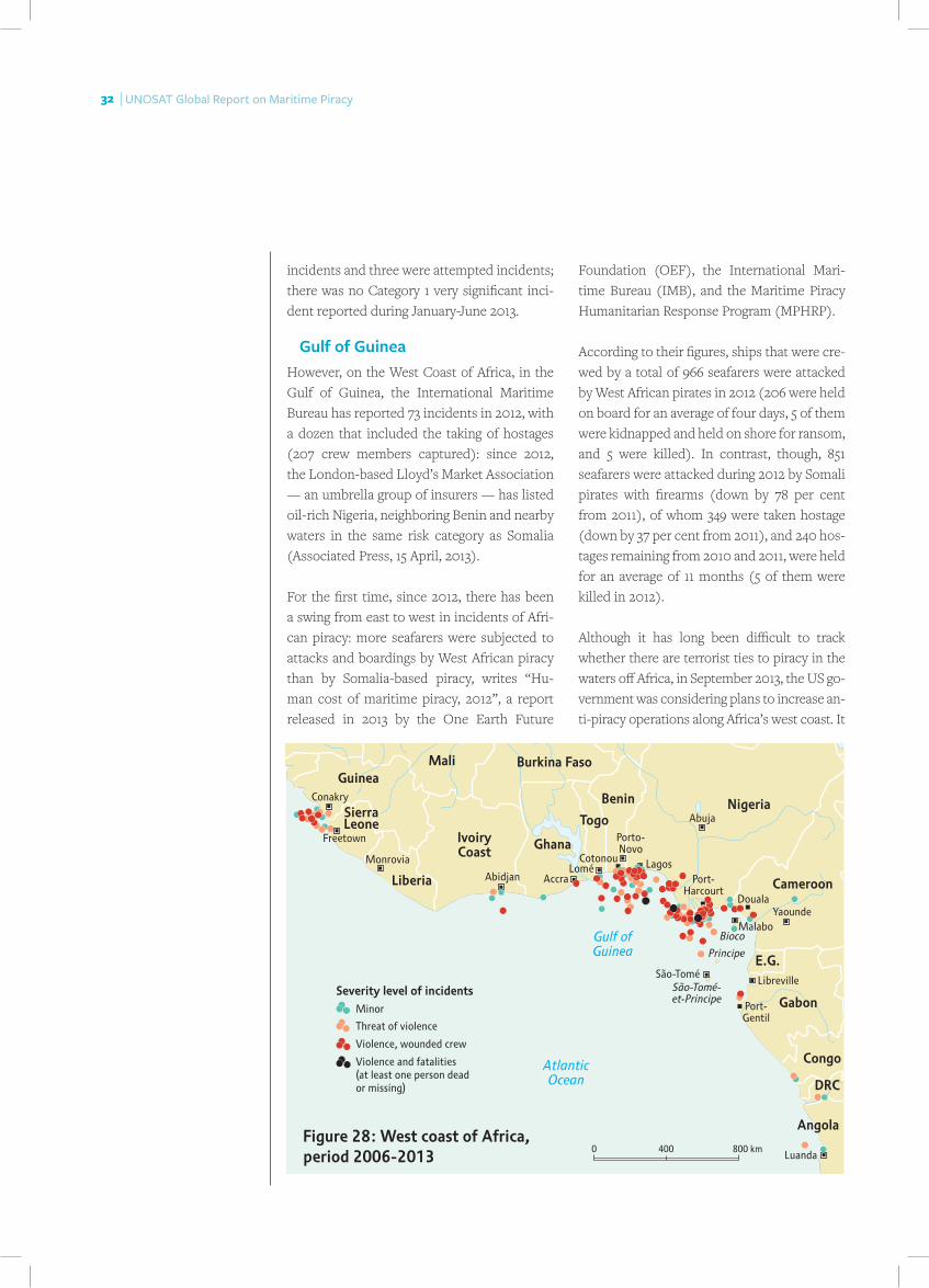
Gulf of GuineaHowever, on the West Coast of Africa, in the Gulf of Guinea, the International Maritime Bureau has reported 73 incidents in 2012, with a dozen that included the taking of hostages (207 crew members captured): since 2012, the London-based Lloyd’s Market Association — an umbrella group of insurers — has listed oil-rich Nigeria, neighboring Benin and nearby waters in the same risk category as Somalia (Associated Press, 15 April, 2013).
For the first time, since 2012, there has been a swing from east to west in incidents of Afri-can piracy: more seafarers were subjected to attacks and boardings by West African piracy than by Somalia-based piracy, writes “Hu-man cost of maritime piracy, 2012”, a report released in 2013 by the One Earth Future
Foundation (OEF), the International Mari-time Bureau (IMB), and the Maritime Piracy Humanitarian Response Program (MPHRP).
According to their figures, ships that were cre-wed by a total of 966 seafarers were attacked by West African pirates in 2012 (206 were held on board for an average of four days, 5 of them were kidnapped and held on shore for ransom, and 5 were killed). In contrast, though, 851 seafarers were attacked during 2012 by Somali pirates with firearms (down by 78 per cent from 2011), of whom 349 were taken hostage (down by 37 per cent from 2011), and 240 hos-tages remaining from 2010 and 2011, were held for an average of 11 months (5 of them were killed in 2012).
Although it has long been difficult to track whether there are terrorist ties to piracy in the waters off Africa, in September 2013, the US go-vernment was considering plans to increase an-ti-piracy operations along Africa’s west coast. It
Luanda
Yaounde
Burkina FasoMali
Gulf ofGuinea
AtlanticOcean
Abidjan AccraLagosLomé
Porto-Novo
Cotonou
Abuja
Port-Harcourt
Douala
Libreville
Port-Gentil
IvoiryCoast Ghana
Togo
Benin Nigeria
Cameroon
E.G.
GabonSão-Tomé-et-Principe
Principe
Figure 28: West coast of Africa,period 2006-2013
Monrovia
Freetown
Conakry
Guinea
SierraLeone
Liberia
Congo
Angola
São-Tomé
BiocoMalabo
DRC
Threat of violence
Minor
Violence, wounded crew
Violence and fatalities (at least one person dead or missing)
Severity level of incidents
0 400 800 km
a geospatial analysis 1995-2013 | 33
fears that some of the profits of the attacks off the coast of Nigeria and Cameroon could be used for ongoing terrorist training or weapons. Washington underlines the growing coordina-tion between Nigeria-based Boko Haram and Al-Qaida in the Islamic Maghreb (AQIM).
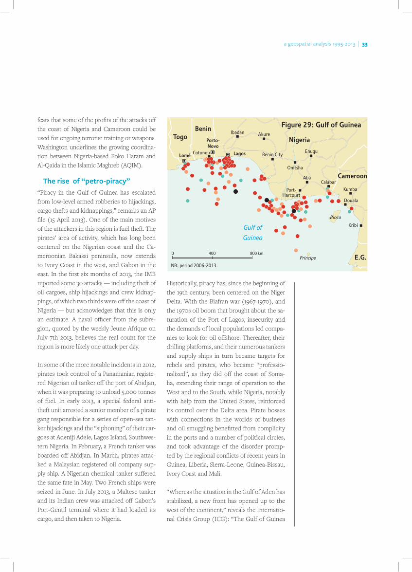
The rise of “petro-piracy”“Piracy in the Gulf of Guinea has escalated from low-level armed robberies to hijackings, cargo thefts and kidnappings,” remarks an AP file (15 April 2013). One of the main motives of the attackers in this region is fuel theft. The pirates’ area of activity, which has long been centered on the Nigerian coast and the Ca-meroonian Bakassi peninsula, now extends to Ivory Coast in the west, and Gabon in the east. In the first six months of 2013, the IMB reported some 30 attacks — including theft of oil cargoes, ship hijackings and crew kidnap-pings, of which two thirds were off the coast of Nigeria — but acknowledges that this is only an estimate. A naval officer from the subre-gion, quoted by the weekly Jeune Afrique on July 7th 2013, believes the real count for the region is more likely one attack per day.
In some of the more notable incidents in 2012, pirates took control of a Panamanian registe-red Nigerian oil tanker off the port of Abidjan, when it was preparing to unload 5,000 tonnes of fuel. In early 2013, a special federal anti-theft unit arrested a senior member of a pirate gang responsible for a series of open-sea tan-ker hijackings and the “siphoning” of their car-goes at Adeniji Adele, Lagos Island, Southwes-tern Nigeria. In February, a French tanker was boarded off Abidjan. In March, pirates attac-ked a Malaysian registered oil company sup-ply ship. A Nigerian chemical tanker suffered the same fate in May. Two French ships were seized in June. In July 2013, a Maltese tanker and its Indian crew was attacked off Gabon’s Port-Gentil terminal where it had loaded its cargo, and then taken to Nigeria.
Historically, piracy has, since the beginning of the 19th century, been centered on the Niger Delta. With the Biafran war (1967-1970), and the 1970s oil boom that brought about the sa-turation of the Port of Lagos, insecurity and the demands of local populations led compa-nies to look for oil offshore. Thereafter, their drilling platforms, and their numerous tankers and supply ships in turn became targets for rebels and pirates, who became “professio-nalized”, as they did off the coast of Soma-lia, extending their range of operation to the West and to the South, while Nigeria, notably with help from the United States, reinforced its control over the Delta area. Pirate bosses with connections in the worlds of business and oil smuggling benefitted from complicity in the ports and a number of political circles, and took advantage of the disorder promp-ted by the regional conflicts of recent years in Guinea, Liberia, Sierra-Leone, Guinea-Bissau, Ivory Coast and Mali.
“Whereas the situation in the Gulf of Aden has stabilized, a new front has opened up to the west of the continent,” reveals the Internatio-nal Crisis Group (ICG): “The Gulf of Guinea
Gulf of
Guinea
LagosLomé
Porto-Novo
Cotonou
Ibadan Akure
Benin CityEnugu
Onitsha
Port-Harcourt
AbaCalabar
Douala
Kumba
Kribi
TogoBenin
Nigeria
Cameroon
E.G.Principe
Bioco
Figure 29: Gulf of Guinea
0 400 800 km
NB: period 2006-2013.
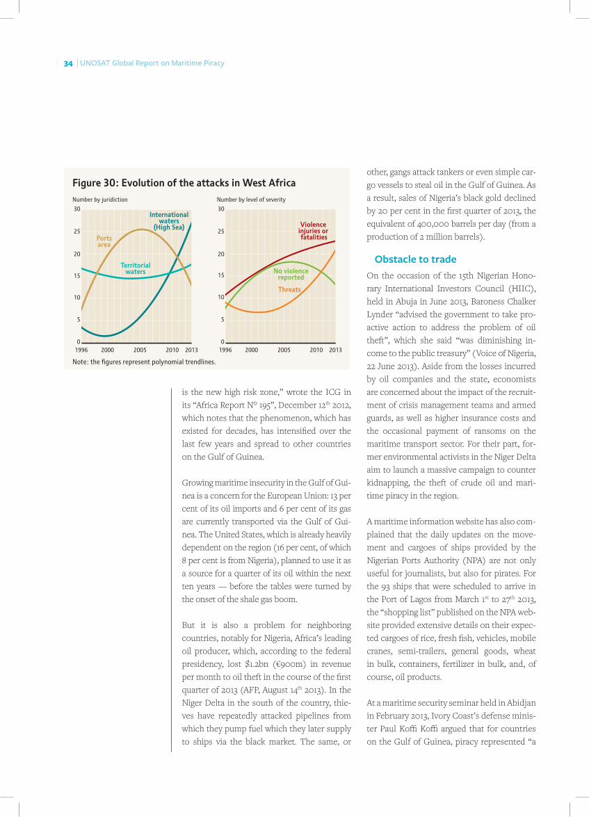
34 | UNOSAT Global Report on Maritime Piracy
is the new high risk zone,” wrote the ICG in its “Africa Report N° 195”, December 12th 2012, which notes that the phenomenon, which has existed for decades, has intensified over the last few years and spread to other countries on the Gulf of Guinea.
Growing maritime insecurity in the Gulf of Gui-nea is a concern for the European Union: 13 per cent of its oil imports and 6 per cent of its gas are currently transported via the Gulf of Gui-nea. The United States, which is already heavily dependent on the region (16 per cent, of which 8 per cent is from Nigeria), planned to use it as a source for a quarter of its oil within the next ten years — before the tables were turned by the onset of the shale gas boom.
But it is also a problem for neighboring countries, notably for Nigeria, Africa’s leading oil producer, which, according to the federal presidency, lost $1.2bn (€900m) in revenue per month to oil theft in the course of the first quarter of 2013 (AFP, August 14th 2013). In the Niger Delta in the south of the country, thie-ves have repeatedly attacked pipelines from which they pump fuel which they later supply to ships via the black market. The same, or
other, gangs attack tankers or even simple car-go vessels to steal oil in the Gulf of Guinea. As a result, sales of Nigeria’s black gold declined by 20 per cent in the first quarter of 2013, the equivalent of 400,000 barrels per day (from a production of 2 million barrels).
Obstacle to tradeOn the occasion of the 15th Nigerian Hono-rary International Investors Council (HIIC), held in Abuja in June 2013, Baroness Chalker Lynder “advised the government to take pro-active action to address the problem of oil theft”, which she said “was diminishing in-come to the public treasury” (Voice of Nigeria, 22 June 2013). Aside from the losses incurred by oil companies and the state, economists are concerned about the impact of the recruit-ment of crisis management teams and armed guards, as well as higher insurance costs and the occasional payment of ransoms on the maritime transport sector. For their part, for-mer environmental activists in the Niger Delta aim to launch a massive campaign to counter kidnapping, the theft of crude oil and mari-time piracy in the region.
A maritime information website has also com-plained that the daily updates on the move-ment and cargoes of ships provided by the Nigerian Ports Authority (NPA) are not only useful for journalists, but also for pirates. For the 93 ships that were scheduled to arrive in the Port of Lagos from March 1st to 27th 2013, the “shopping list” published on the NPA web-site provided extensive details on their expec-ted cargoes of rice, fresh fish, vehicles, mobile cranes, semi-trailers, general goods, wheat in bulk, containers, fertilizer in bulk, and, of course, oil products.
At a maritime security seminar held in Abidjan in February 2013, Ivory Coast’s defense minis-ter Paul Koffi Koffi argued that for countries on the Gulf of Guinea, piracy represented “a
1996 2000 2005 2010 20130
10
15
5
20
25
30
Number by juridiction
Portsarea
Internationalwaters
(High Sea)
Territorialwaters
Figure 30: Evolution of the attacks in West Africa
Note: the figures represent polynomial trendlines.
1996 2000 2005 2010 20130
10
5
15
20
25
30
Number by level of severity
No violencereported
Threats
Violenceinjuries or fatalities
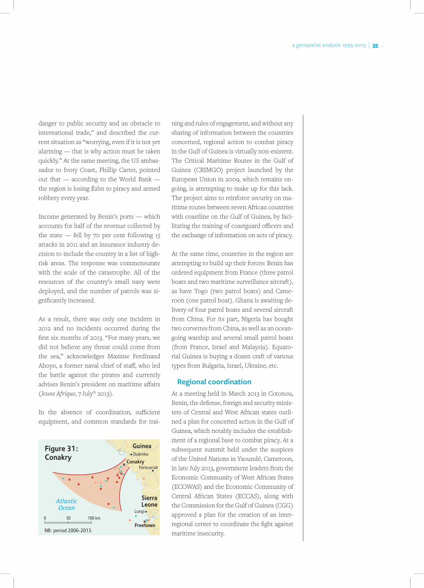
a geospatial analysis 1995-2013 | 35
danger to public security and an obstacle to international trade,” and described the cur-rent situation as “worrying, even if it is not yet alarming — that is why action must be taken quickly.” At the same meeting, the US ambas-sador to Ivory Coast, Phillip Carter, pointed out that — according to the World Bank — the region is losing $2bn to piracy and armed robbery every year.
Income generated by Benin’s ports — which accounts for half of the revenue collected by the state — fell by 70 per cent following 15 attacks in 2011 and an insurance industry de-cision to include the country in a list of high-risk areas. The response was commensurate with the scale of the catastrophe. All of the resources of the country’s small navy were deployed, and the number of patrols was si-gnificantly increased.
As a result, there was only one incident in 2012 and no incidents occurred during the first six months of 2013. “For many years, we did not believe any threat could come from the sea,” acknowledges Maxime Ferdinand Ahoyo, a former naval chief of staff, who led the battle against the pirates and currently advises Benin’s president on maritime affairs (Jeune Afrique, 7 Julyth 2013).
In the absence of coordination, sufficient equipment, and common standards for trai-
ning and rules of engagement, and without any sharing of information between the countries concerned, regional action to combat piracy in the Gulf of Guinea is virtually non-existent. The Critical Maritime Routes in the Gulf of Guinea (CRIMGO) project launched by the European Union in 2009, which remains on-going, is attempting to make up for this lack. The project aims to reinforce security on ma-ritime routes between seven African countries with coastline on the Gulf of Guinea, by faci-litating the training of coastguard officers and the exchange of information on acts of piracy.
At the same time, countries in the region are attempting to build up their forces: Benin has ordered equipment from France (three patrol boats and two maritime surveillance aircraft), as have Togo (two patrol boats) and Came-roon (one patrol boat). Ghana is awaiting de-livery of four patrol boats and several aircraft from China. For its part, Nigeria has bought two corvettes from China, as well as an ocean-going warship and several small patrol boats (from France, Israel and Malaysia). Equato-rial Guinea is buying a dozen craft of various types from Bulgaria, Israel, Ukraine, etc.
Regional coordinationAt a meeting held in March 2013 in Cotonou, Benin, the defense, foreign and security minis-ters of Central and West African states outli-ned a plan for concerted action in the Gulf of Guinea, which notably includes the establish-ment of a regional base to combat piracy. At a subsequent summit held under the auspices of the United Nations in Yaoundé, Cameroon, in late July 2013, government leaders from the Economic Community of West African States (ECOWAS) and the Economic Community of Central African States (ECCAS), along with the Commission for the Gulf of Guinea (CGG) approved a plan for the creation of an inter-regional center to coordinate the fight against maritime insecurity.
0 50 100 km
NB: period 2006-2013.
AtlanticOcean
Dubreka
ConakryForecariah
Lungi
Freetown
Guinea
SierraLeone
Figure 31: Conakry
36 | UNOSAT Global Report on Maritime Piracy
The Heads of State or their representatives from 25 West and Central African countries, including 13 Presidents, endorsed a memo-randum of understanding on maritime safety and security, as well as a code of conduct on the prevention and repression of piracy and armed robbery (similar to the code adopted in Djibouti in 2008 for East Africa). They also called for the establishment of a “regional ra-pid intervention force” and the deployment of an international naval force, similar to the one off Somalia.
The Cameroonian government, which hosted the summit, had launched a 2009 offensive against pirates based in the Bakassi peninsula, close to the Niger Delta (which was the subject of a long-drawn-out dispute with Nigeria until the International Court of Justice recognized Cameroon’s sovereignty). Members of the elite Rapid Intervention Battalion (RIB) were ap-pointed to five military posts (Cameroon took full possession of its sovereignty over Bakassi on August 14th 2013, in the wake of five years of transition administration).
Organized criminalityThe theft of fuel by pirates off the coast of Ni-geria, Benin and Ivory Coast should be viewed in the framework of a wider criminal context that includes:F extortion: oil companies are forced to buy protection from communities or security companies to prevent the sabotage of their equipment and facilities;F the misappropriation of funds on a natio-nal level: the Nigerian parliament recently brought to light a multi-billion dollar fuel sub-sidy fraud;F smuggling: subsidized fuel is illicitly sold on markets where it can fetch three times its of-ficial price;F the kidnapping of sailors and oil company employees (207 sailors and crew members were taken hostage in the Gulf of Guinea in
2012, Their release was negotiated at a cost of €200,000-300,000 per person).
“Fishermen by day and pirates by night”: as elsewhere, fishermen are often involved in smuggling or even piracy. And in some cases their involvement is political. “It has long been difficult to track whether there are terrorist ties to piracy in the waters off Africa, AP reported in Washington (March 24th 2013). According to the same source, officials are worried that even if Boko Haram insurgents are not directly involved in the attacks off Nigeria and Came-roon, they may be reaping some of the profits and using the money for ongoing terrorist trai-ning or weapons.”The stolen petrol ends up on parallel markets in a dozen countries in region. In Benin, for example, two thirds of the petrol consumed is sourced from fuel that has been smuggled into the country from neighboring Nigeria. Pirates have also been known to barter fuel in exchange for drugs, arms, and contraband liquor. On oc-casion, points out the United Nations Office on Drugs and Crime (UNODC)1, coastal trading vessels and small tankers arrive in the Gulf to collect cargoes of stolen fuel, which they deli-ver to countries as far away as Congo or trans-fer to larger tankers further off the coast.“It follows that the different types of traffic-king feed into each other,” explains UNODC, which outlines activities in the region:F drugs from Latin America arrive in West Africa (where the regional market is control-led by Nigerian gangs, before being routed to Europe);F the local drugs market (cannabis planta-tions, imports of LSD, methamphetamine pro-duction in laboratories in the region);F trafficking of children sold by their parents (for forced labour in agriculture, or to provide servants to rich families in Gabon, Cameroon and Equatorial Guinea);
1 See http://geopolcrim.info/?p=8217
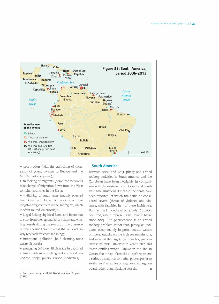
a geospatial analysis 1995-2013 | 37
F prostitution (with the trafficking of thou-sands of young women to Europe and the Middle East every year);F trafficking of migrants (organized networks take charge of migration flows from the West to richer countries in the East);F trafficking of small arms (mainly sourced from Chad and Libya, but also from more longstanding conflicts in the subregion, which is often routed via Nigeria)2;F illegal fishing (by local fleets and boats that are not from the region, factory ships and wha-ling vessels during the season, or the presence of unauthorized craft in areas that are exclusi-vely reserved for coastal fishing);F intentional pollution (hold cleaning, toxic waste disposal);F smuggling (of ivory, illicit trade in captured animals with Asia, endangered species desti-ned for Europe, precious wood, medicines).
2 See report 2012 by the Global Risk Identification Program (GRIP).
South AmericaBetween 2006 and 2013, piracy and armed robbery activities in South America and the Caribbean have been negligible in compari-son with the western Indian Ocean and South East Asia situations. Only 216 incidents have been reported, of which 102 could be consi-dered severe (threat of violence and vio-lence, with fatalities in 3 of these incidents). For the first 8 months of 2013, only 16 attacks occurred, which represents the lowest figure since 2003. The phenomenon is an armed robbery problem rather than piracy, as inci-dents occur mainly in ports, coastal waters or rivers. Attacks on the high sea remain rare, and most of the targets were yachts, particu-larly vulnerable, attacked in Venezuelan and lesser Antilles waters. Unlike in the Indian Ocean, the threat of attacks doesn’t represent a serious disruption to traffic, pirates prefer to steal crews’ valuables or engines and cargo on board rather than hijacking vessels. O
Limon
0 1,000 km
GuatemalaBelize
Mexico
CubaHaiti
Jamaica
HondurasEl Salvador
Nicaragua
Costa RicaPanamá
ColombiaVenezuela
Ecuador
PeruBrazil
Bolivia
Paraguay
Argentina
Chile
Guyana
SurinamGuyane(France)
ParamariboGeorgetown
Caracas
Bogota
Quito
Lima
La Paz Brasilia
Salvador
Havana
Port-au-PrinceKingston
Fortaleza
DominicanRepublic
Rio deJaneiro
Machala
Cumaná
Pacific
Ocean
South
Atlantic
Ocean
Caribbean Sea
Figure 32: South America,period 2006-2013
BelemSão Luis
Threat of violence
Minor
Violence, wounded crew
Violence and fatalities (at least one person dead or missing)
Severity level of the events
38 | UNOSAT Global Report on Maritime Piracy
Being appropriately informed on piracy...The best way to understand the trends and geography of pi-racy is to build a reliable database gathering events of piracy or armed robbery. So far, several organizations are collecting data and reports of attacks or incidents coming from mari-time companies, vessels, or focal points. IMO is currently managing the most comprehensive database, offering a global and precise overview of incidents that have taken place since 1995, which means almost two decades of information.
This database is undoubtedly the best existing tool helping to keep track of all declared incidents (there is a chance that not all incidents are reported). IMO is permanently reviewing the database and how it can be further improved. This study has identified the following potential areas for improvement: F Georeferencing should be systematically provided in deci-mal coordinates together with, if or when possible, GPS data.F The descriptions of incidents are comprehensive and use-ful, but can be challenging to exploit from a statistical point of view. A consolidated “severity index” such as the one pro-posed in this report should be defined on the basis of factual criteria and presented as quantitative data: number of fatali-ties, injured crew, threat to persons, materiel stolen or crew robbed (yes or no), etc.F Integrate a new indicator such as “distance to coast” which gives an idea of pirate’s capacities; a discussion will be neces-sary to chose the best measure, so it can be accurate as well as practicalF Quantifying what is given as qualitative data whenever pos-sible, so that it can be treated as a statistical series, easier to handle in order to identify main historical and geographical trends, e.g. when there is a sentence like “more than 5 attac-kers”, use a number (5). F The analysis of the database has shown a particular geogra-phical distribution of incidents which does not necessarily fit well with the currently used regional breakdown. A revised geographical breakdown could be discussed and agreed upon.F In conclusion, action could be taken to simultaneously standardize existing data and improve the modus operandi to collect information on future incidents. In addition, a routine could be established so that people working on consolida-ting the database could directly reach and interview maritime companies in order to get missing information or details of an unclear incident declaration.
… and acting in the fieldIn its recommendations issued at the end of November 2013, the UN Security Council called upon the member states in-volved in international maritime transport and trade to strengthen their military presence in order to pursue their deterrent and possibly repressive effect helping coastal states to strengthen their ability to arrest and prosecute pirates. It is also understood that it is a necessity to bring to court not only the perpetrators but also the sponsors and financiers, who are never at sea but are working behind the scenes with internatio-nal criminal networks. Surveillance and repression, seen as a temporary response to an emergency, will need to be gradually replaced in the long term by a focus on local development, which seems to be the only way to dry up the sources of piracy.
In regard to Somalia, the real urgency is to give major tech-nical and financial support to the state as it goes through the process of reconstruction, to provide the basis of viable governance, but without imposing an inapplicable model, ra-ther taking into consideration the regional and clan structures that underpin Somali society. This support should also be ex-tended to the entities of Puntland and Somaliland, often the source of the piracy. With the observed cessation of piracy off the coast of Somalia, a major opportunity has now surfaced to halt further recruitment for piracy, but that would require urgent implementation of the above support.
For young Somalis not to be tempted to return to piracy or get enrolled into militias, but rather to find on site jobs allowing them to support their families, a particular effort has to be made for extended support for the creation of jobs and busi-ness projects. But to complete such a project, there must be an emphasis on building capacities such as schools, vocatio-nal training centers, health centers and electrical power grids, as well as support for local NGOs and women’s associations, to help civil society become a reliable social actor.
The international community should help strengthen the law of the sea and its implementation, in order to fight against pi-racy, but also to prevent plundering of fisheries by industrial vessels and illegal dumping of hazardous waste, and assist the Somali authorities to restore coastguard forces and give sup-port to the development of a modern judicial system, with rule of law, courts and police forces. O
Conclusions
a geospatial analysis 1995-2013 | 39
The Human Cost of Maritime Piracy 2012Oceans Beyond Piracy, working paper, One Earth Future Foundation, Broomfield, Colorado, United States.
The Economic Cost of Somali Piracy2011 and 2012 editions, Oceans Beyond Piracy, working paper, One Earth Future Foundation, Broomfield, Colorado, United States.
Pirates and Privateers: Managing the Indian Ocean’s private security Boom James Brown, Lowy institute for International Policy, Sydney (Australia), September 2012.
A Secret Subsidy: Oil Companies, the Navy and the Response to Piracy Emma Hughes and Mika Minio-Paluello, Platform London, 2013.
Piracy off the Horn of Africa Congressional Research Service, Report for Congress, April 2011.
Tour d’horizon: pirateries, du Golfe d’Aden au Golfe de Guinée http://geopolcrim.info/?page_id=8631, Criminalités, Observatoire géopolitique des criminalités, Paris, June 2013.
Somali Piracy and the Monsoon SeasonsWorld Piracy Update, Bergen Risk Solutions, August 2012.
Pirates, Smugglers and Corrupt Tycoons Social Bandits in AfricaForum for African Investigative Reporters (FAIR) Transnational Investigation 2011. The pirates of Somalia: Ending the Threat, Rebuilding a NationThe World Bank, Regional Vice-Presidency for Africa, Washington DC, 2013.
Review of Maritime Transport 2012 United Nations Conference on Trade and Development (UNCTAD), Geneva (Switzerland).
Piracy and Armed Robbery against Ships ICC International Maritime Bureau (IMB), London, annual reports 2009, 2010, 2011 and 2012.
Global Marine Trends 2030Lloyd’s Register, QinetiQ and University of Strathclyde in Glasgow, 2013.
The Big Story : PiratesNew Internationalist, September 2013.
Piracy The East Africa/Somalia Situation Practical Measures to Avoid, Deter or Delay Piracy Attacks Oil Companies International Marine Forum (OCIMF), London, 2009.
The Globalization of Crime: a Transnational Organized Crime Threat Assessment (TOCTA)United Nations Office on Drugs and Crime (UNODC), Vienna (Austria), 2010.
International Shipping Facts and Figures – Information Resources on Trade, Safety, Security, EnvironmentInternational Maritime Organization, London, March 2012.
Maritime Security in Asia: What the EU Can DoAgora Asia-Europe, Foundation for International Relations and Foreign Dialogue (FRIDE), Brussels (Belgium) , March 2012.
Piracy and Maritime Security: Regional Characteristics and Political, Military, Legal and Economic ImplicationsStiftung Wissenschaft und Politik (SWP), German institute for international and security affairs, Berlin (Germany), 2011.
Piracy in Comparative Perspective: Problems, Strategies Charles H. Norchi, Gwenaële Proutière-Maulion, Law, Editions A.Pedone, Paris (France), September 2012.
Best Management Practices for Protection against Somalia based piracy World Shipping Council, Witherby Publishing Group, 2011
Spatial Analysis of Somali pirate attacks in 2009UNITAR – UNOSAT, Geneva (Switzerland), June 2010.
Piraterie: Perturbation de l’économie maritime?Note de synthèse, Institut Supérieur d’Economie Maritime (ISEMAR), Nantes / Saint-Nazaire, Octobre 2010.
A Journalist in the Hands of Somali PiratesKassim Mohamed, Committee to Protect Journlists (CPJ), October 2009.
Rapport d’information sur les sociétés militaires privéesAssemblée nationale française, Paris, February 2012.
Report of the Secretary-General on Specialized Anti-Piracy Courts in Somalia and other States in the Region Security Council of the United Nations, January 2012.
Report of Jack Lang The Special Adviser to the Secretary-General on Legal Issues related to Piracy off the Coast of Somalia for the information of the members of the Security Council, January 2011.
Somalia and the PiratesEuropean Security Forum (ESF) working paper, December 2009.
Internet linksCommercial Crime Services (CCS)International Chamber of Commerce (ICC) http://www.icc-ccs.org/
Piracy Reporting Centre International Maritime Bureau (IMB) http://www.icc-ccs.org/piracy-reporting-centre
Live Piracy Map 2013International Maritime Bureau (IMB) http://www.icc-ccs.org/piracy-reporting-centre/live-piracy-map
Live Piracy ReportInternational Maritime Bureau (IMB) http://www.icc-ccs.org/piracy-reporting-centre/live-piracy-report
References
UNITAR / UNOSATPalais des NationsCH-1211 Geneva 10SwitzerlandT: +41 22 767 4020F: +41 22 917 8993E-mail: [email protected]/unosat
UNOSAT is a center of excellence for satellite imagery analysis providing geographic information, innovative solutions, and applied research to the United Nations family and member states. Established in 2001 UNOSAT conducts analysis and mapping, training, knowledge transfer and capacity development in the areas of humanitarian relief, human security, strategic territorial planning, and development.
UNOSAT is the Operational Satellite Applications Programme of the United Nations Institute for Training and Research (UNITAR).