Unmanned Aircraft Solutions -...
12
Unmanned Aircraft Solutions TRANSFORMING THE WAY THE WORLD WORKS
Transcript of Unmanned Aircraft Solutions -...

Unmanned Aircraft SolutionsTRANSFORMING THE WAY THE WORLD WORKS

TRANSFORMING THE WAY THE WORLD WORKS2
Trusted PerformanceSuperior Image Accuracy
WHY TRIMBLE UAS?
Surveying and mapping professionals across the world rely on and successfully use Trimble UAS. Whether it’s a multi-rotor aircraft to fly into and out of tight places or a longer-range fixed-winged craft with a highly precise camera and GNSS receiver, Trimble UAS are ideal for the job—any job. With industry-leading field and office software to make data capture and processing as simple as possible, Trimble solutions deliver greater:
► Affordability. While UAS was once reserved for firms with large budgets, Trimble’s cost effective solutions are practical for a wide range of users.
► Safety. Trimble UAS enables surveying of rugged, hazardous or hard-to-reach areas without risk of injury.
► Efficiency. Trimble UAS makes data collection easier and faster, especially compared to traditional, terrestrial based surveying technology.
► Responsiveness. With the ability to quickly execute a flight and capture data, Trimble UAS enables rapid response to customer needs.
► Versatility. Trimble UAS is an advanced technology that can easily serve numerous professional markets and applications.
BUILT FOR ALL YOUR APPLICATION NEEDS
Trimble UAS solutions are designed to drastically reduce the time and costs for collecting aerial data and guarantee the reliability you need for a diversity of markets including:
► Engineering & Surveying ► Mining ► Civil & Heavy Earthworks Construction ► Oil & Gas ► Environmental & Landfill ► Public Agencies ► Agriculture & Forestry

TRANSFORMING THE WAY THE WORLD WORKS 3
Within each of these industries, customers rely on Trimble UAS for:
► Boundary & topographic surveys ► Survey grade mapping ► Power line modeling ► Field leveling ► Site & route planning ► Progress monitoring ► As-built surveys ► Resource mapping ► Disaster analyses ► Volume determinations
From a single flight, operators can produce a range of deliverables including:
► Topographic contours ► 3D surface models ► Orthophotographs ► Normalized Difference Vegetation Index (NDVI) maps
Industry-leading survey and mapping solutions.
Trimble is a leader in aerial imaging innovation. By setting new industry
standards in high-precision UAS technology, we enable smarter decision
making through better spatial data—improving your deliverables and the
efficiency at which you can provide them.

TRANSFORMING THE WAY THE WORLD WORKS4
UX5 HP Unmanned Aircraft
HIGH ACCURACY TECHNOLOGY
The Trimble UX5 HP Unmanned Aircraft System sets a new standard in high-accuracy UAS technology. It’s engineered to capture sharp, color-rich images for superior geospatial deliverables. The UX5 HP features an integrated Trimble GNSS receiver and a 36 MP camera for industry-leading image quality and data accuracy.
High-precision Imaging for Superior Deliverables
The UX5 HP utilizes the most recent advances in digital imaging, ensuring optimal image quality and the highest photogrammetric accuracy. Integrating a high-performance GNSS receiver with a high resolution camera, the UX5 HP collects precise data and achieves a leading level of image resolution—capturing precision-sharp aerial photographs down to 1 cm GSD. The UX5 HP’s postprocessed kinematic (PPK) GNSS technology lets you establish image locations in absolute coordinate systems, minimizing or eliminating the need for ground control points. You’ll spend less time preparing to fly and more time capturing highly precise data.

TRANSFORMING THE WAY THE WORLD WORKS 5
Configure For The Job
No two projects are the same. That’s why the UX5 HP comes with increased system flexibility. You can choose a near-infrared or a red-green-blue (RGB) sensor and lens combination based on your project needs. Lens options range from a 35 mm for high accuracy, a 15 mm wide-angle for greater coverage, or a 25 mm for the best of both: detailed imagery and superb coverage.
Trimble’s next generation, high precision solution delivers unrivaled accuracy.
UX5 HP Features
► High-performance Trimble GNSS receiver
► Postprocessed kinematic (PPK) GNSS technology
► Survey quality accuracy without ground control
► 36 MP, Sony a7R, full-frame, high-resolution camera
► Orthomosaic resolution down to 1 cm GSD & 3D models with 1,000 pts/m²
► Fully automated Trimble® Access™ software workflows for ease-of-use and safe operation
► Simple data processing with Trimble Business Center photogrammetry module

TRANSFORMING THE WAY THE WORLD WORKS6
UX5 Unmanned Aircraft
SETTING THE STANDARD
For mapping and surveying professionals around the world, Trimble’s UX5 Unmanned Aircraft System has set the standard in UAS performance, delivering unparalleled results and efficiency.
The UX5 is a cost-effective solution for general survey and agriculture applications. And, with the 24 MP Sony Alpha a5100 camera for enhanced image accuracy, the UX5 represents a tremendous benefit at a competitive value— offering more for less.
Trusted Performance
Trimble’s unmanned systems are robust and durable. Made from impact-resistant foam, they deliver trusted performance, even in harsh environments.
You can depend on Trimble UX5 and UX5 HP to stand up to whatever nature dishes out: from extreme temperatures and winds up to 65 km, to light rain. Each model is ideal for conditions where many other unmanned aerial vehicles struggle to operate.

TRANSFORMING THE WAY THE WORLD WORKS 7
Trimble’s popular unmanned system is a robust and effective solution at a competitive value.
UX5 Features
► 24 MP camera for high image acquisition quality and data accuracy
► All-terrain and all-weather performance
► Reverse thrust for precise landings in confined spaces
► A durable and reliable solution for intensive use
► Fully automated Trimble Access workflows for ease-of-use and safe operation
► Simple data processing with Trimble Business Center photogrammetry module
Trimble’s motor-propeller design ensures reliable takeoffs, and our advanced reverse-thrust technology means you’ll have accurate and predictable landings even in confined areas.
Whether you work in icy snow caps, windy coastlines, or rocky terrains, the UX5 and UX5 HP will continue to capture the highest quality data, flight after flight.

TRANSFORMING THE WAY THE WORLD WORKS8
ZX5 Multirotor
TESTED AND PROVEN
Tested and proven, the Trimble ZX5 Multirotor is built to execute tough, everyday jobs quickly, even in tight spaces. It requires no launcher, is easy to assemble and includes everything you need to capture high quality geo-referenced photos for applications such as aerial mapping and inspections.
Precise Data, Fast Processing
The Trimble ZX5 Multirotor includes a 24 MP camera, which enables you to capture high quality aerial imagery and achieve image resolution down to 1 cm for superior image quality. The ZX5 is equipped to capture live video imagery for inspection applications such as civil infrastructure, utilities, and oil and gas pipelines.

TRANSFORMING THE WAY THE WORLD WORKS 9
It Goes to Work Fast. So You Can Get in and out Quickly
The Trimble ZX5 sets up in minutes and comes equipped with an industry leading flight control system for unprecedented performance and precision. Its vertical takeoff and landing capability enables users to work in tight places and obstructed environments where fixed wing solutions are less suitable. And you can count on it to stay on the job, flight after flight, thanks to its proven and reliable design, rugged, durable chassis made from light, fracture-resistant carbon and the highest quality components available.
Everything you need to capture reliable, accurate aerial data.
ZX5 Features
► Outstanding flight stability and performance even in strong winds
► Includes a 24 MP Sony camera system and Trimble Access Aerial Imaging flight planning software
► Image resolution down to 1 cm
► Light, compact, foldable carbon design
► Up to 20 minute mission duration and 2 km range
► Easy data processing in Trimble Business Center Photogrammetry Module or Trimble Inpho® UASMaster module

TRANSFORMING THE WAY THE WORLD WORKS10
Software
TRIMBLE VISION
Measure With Speed and Accuracy
The data you collect with Trimble UAS can be integrated using Trimble VISION™ technology. Whether it’s our total stations, the TX8, 3D Laser scanners, or the innovative V10 imaging rover, you’ll get a one-of-a-kind solution.
By combining data collected with Trimble’s leading-edge photogrammetry technology—you’ll be able to visualize your project from multiple perspectives, measure points within the images and create 3D models of the infrastructure and terrain.
POWERFUL OFFICE SOFTWARE FOR DATA PROCESSING
Trimble Business Center Aerial Photogrammetry Module
The Trimble Business Center Aerial Photogrammetry module is designed to work seamlessly with Trimble Business Center standard and advanced survey modules, making it possible to process complete mapping projects including aerial imagery, Trimble VISION imagery and total station observations. Additionally, GNSS information, base station data, and onboard images can be imported into the module to produce point clouds, Triangulated Irregular Network (TIN) models, and contour maps of the area flown. These can then be used in calculating volumes, excavation planning, drainage planning and many other functions.

TRANSFORMING THE WAY THE WORLD WORKS 11
SIMPLE WORKFLOWS WITH TRIMBLE ACCESS
With the Trimble Access Aerial Imaging application loaded onto the Trimble Tablet Rugged PC or on a Windows Tablet, you have an easy-to-use, single software tool for planning our aerial missions, performing pre-flight checks and monitoring your flights. The intuitive workflows are so quick and simple that the UX5 and ZX5 systems can be prepared for flight in only 5 minutes, greatly minimizing downtime. While in the field, the operator is guided through the pre- and post-flight sequences with step-by-step digital checklists. Many of the Trimble UX5 checks are automatically verified by the software and do not require any interaction from the operator.
Trimble Inpho UASMaster Module
The Trimble Inpho UASMaster module combines ease of use with the ull power of a photogrammetric workstation for creating powerful deliverables from images collected from UAS aerial mapping and surveying systems. Based on state-of- the-art Trimble Inpho technology, the software bridges the gap between simple near black-box workflows for nonphotogrammetrists and photogrammetry expert workflows. UASMaster includes advanced technology that has been customized to provide high quality results from the special characteristics of UAS data and easily integrates into the Inpho world of photogrammetry and 3rd party workflows.
Process UAS data and create powerful photogrammetric deliverables.
Trimble’s advanced photogrammetric modules feature state-of-the-art
image processing technologies that enable you to optimize process data
from the UX5, UX5 HP and ZX5 to produce impressive deliverables.
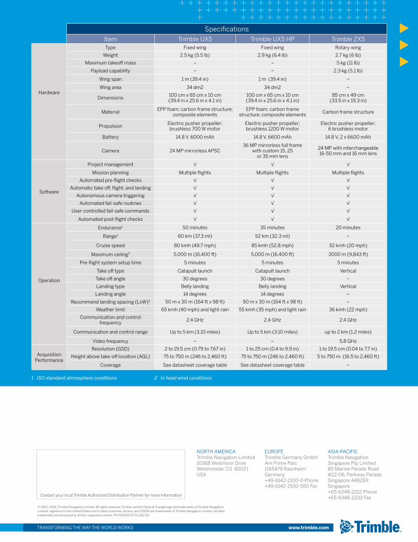
SpecificationsItem Trimble UX5 Trimble UX5 HP Trimble ZX5
Hardware
Type Fixed wing Fixed wing Rotary wing
Weight 2.5 kg (5.5 lb) 2.9 kg (6.4 lb) 2.7 kg (6 lb)
Maximum takeoff mass – – 5 kg (11 lb)
Payload capability – – 2.3 kg (5.1 lb)
Wing span 1 m (39.4 in) 1 m (39.4 in) –
Wing area 34 dm2 34 dm2 –
Dimensions 100 cm x 65 cm x 10 cm(39.4 in x 25.6 in x 4.1 in)
100 cm x 65 cm x 10 cm(39.4 in x 25.6 in x 4.1 in)
85 cm x 49 cm(33.5 in x 19.3 in)
Material EPP foam; carbon frame structure; composite elements
EPP foam; carbon frame structure; composite elements Carbon frame structure
Propulsion Electric pusher propeller; brushless 700 W motor
Electric pusher propeller; brushless 1200 W motor
Electric pusher propeller; 6 brushless motor
Battery 14.8 V, 6000 mAh 14.8 V, 6600 mAh 14.8 V, 2 x 6600 mAh
Camera 24 MP mirrorless APSC36 MP mirrorless full frame
with custom 15, 25 or 35 mm lens
24 MP with interchangeable 16-50 mm and 16 mm lens
Software
Project management √ √ √
Mission planning Multiple flights Multiple flights Multiple flights
Automated pre-flight checks √ √ √
Automatic take off, flight, and landing √ √ √
Autonomous camera triggering √ √ √
Automated fail-safe routines √ √ √
User-controlled fail-safe commands √ √ √
Automated post-flight checks √ √ √
Operation
Endurance1 50 minutes 35 minutes 20 minutes
Range1 60 km (37.3 ml) 52 km (32.3 ml) –
Cruise speed 80 kmh (49.7 mph) 85 kmh (52.8 mph) 32 kmh (20 mph)
Maximum ceiling2 5,000 m (16,400 ft) 5,000 m (16,400 ft) 3000 m (9,843 ft)
Pre-flight system setup time 5 minutes 5 minutes 5 minutes
Take off type Catapult launch Catapult launch Vertical
Take off angle 30 degrees 30 degrees –
Landing type Belly landing Belly landing Vertical
Landing angle 14 degrees 14 degrees –
Recommend landing spacing (LxW)2 50 m x 30 m (164 ft x 98 ft) 50 m x 30 m (164 ft x 98 ft) –
Weather limit 65 kmh (40 mph) and light rain 55 kmh (35 mph) and light rain 36 kmh (22 mph)
Communication and control frequency 2.4 GHz 2.4 GHz 2.4 GHz
Communication and control range Up to 5 km (3.10 miles) Up to 5 km (3.10 miles) up to 2 km (1.2 miles)
Video frequency – – 5.8 GHz
Acquisition Performance
Resolution (GSD) 2 to 19.5 cm (0.79 to 7.67 in) 1 to 25 cm (0.4 to 9.9 in) 1 to 19.5 cm (0.04 to 7.7 in)
Height above take-off location (AGL) 75 to 750 m (246 to 2,460 ft) 75 to 750 m (246 to 2,460 ft) 5 to 750 m (16.5 to 2,460 ft)
Coverage See datasheet coverage table See datasheet coverage table –
1 ISO standard atmosphere conditions 2 In head wind conditions
TRANSFORMING THE WAY THE WORLD WORKS www.trimble.com
NORTH AMERICATrimble Navigation Limited10368 Westmoor DriveWestminster CO 80021 USA
EUROPETrimble Germany GmbHAm Prime Parc 1165479 Raunheim Germany+49-6142-2100-0 Phone+49-6142-2100-550 Fax
ASIA-PACIFICTrimble Navigation Singapore Pty Limited 80 Marine Parade Road#22-06, Parkway ParadeSingapore 449269 Singapore+65-6348-2212 Phone+65-6348-2232 FaxContact your local Trimble Authorized Distribution Partner for more information
© 2013–2016, Trimble Navigation Limited. All rights reserved. Trimble and the Globe & Triangle logo are trademarks of Trimble NavigationLimited, registered in the United States and in other countries. Access, and VISION are trademarks of Trimble Navigation Limited. All othertrademarks are the property of their respective owners. PN 022543-577G (08/16)