United States Apache-Sitgreaves Southwestern Region ...
32
United States Department of Agriculture Forest Service Southwestern Region August 2015 Apache-Sitgreaves National Forests Plan Monitoring and Evaluation Report Fiscal Year 2014
Transcript of United States Apache-Sitgreaves Southwestern Region ...

United States Department of Agriculture
Forest Service
Southwestern Region
August 2015
Apache-Sitgreaves National Forests Plan Monitoring and Evaluation Report Fiscal Year 2014

The U.S. Department of Agriculture (USDA) prohibits discrimination in all its programs and
activities on the basis of race, color, national origin, age, disability, and where applicable, sex,
marital status, familial status, parental status, religion, sexual orientation, genetic information,
political beliefs, reprisal, or because all or part of an individual’s income is derived from any
public assistance program. (Not all prohibited bases apply to all programs.) Persons with
disabilities who require alternative means for communication of program information (Braille,
large print, audiotape, etc.) should contact USDA’s TARGET Center at (202) 720-2600 (voice and
TTY). To file a complaint of discrimination, write to USDA, Director, Office of Civil Rights,
1400 Independence Avenue, SW, Washington, DC 20250-9410, or call (800) 795-3272 (voice) or
(202) 720-6382 (TTY). USDA is an equal opportunity provider and employer.
Printed on recycled paper – August, 2015

i
Table of Contents
Introduction .............................................................................................................................. 1
Integrated Resource Restoration .............................................................................................. 1
Watershed and Air Quality Management ................................................................................. 1
Fire and Fuels Management ..................................................................................................... 2
Cultural Resources ................................................................................................................... 3
Rangeland Management ........................................................................................................... 9
Terrestrial Wildlife ................................................................................................................. 10
Threatened, Endangered, Proposed, and Sensitive Species (TEPS) ....................................... 13
Mexican Gray Wolf Reintroduction Program ........................................................................ 13
Aquatic Species ...................................................................................................................... 14
Transportation ........................................................................................................................ 17
Lands and Minerals ................................................................................................................ 21
Forest Products / Resource Management ............................................................................... 23
Biomass/Hazardous Fuels Utilization .................................................................................... 24
Insects and Diseases ............................................................................................................... 24
Recreation ............................................................................................................................... 25
Plan Revision .......................................................................................................................... 28
List of Figures
Figure 1. A prescribed fire project on Clifton Ranger District which resulted in improved
forage and ecological condition in grassland and savanna vegetation types was
monitored for BMP implementation and effectiveness using new national protocols. ..... 2 Figure 2. Prescribed fire near Greer, AZ, fall, 2014. ................................................................. 3 Figure 3. Caldwell Cabin Recreational Rental--a National Register-eligible PHA. ................. 4 Figure 4. “Before” photo of the interior of the Double Circle Ranch Lodge with the Formica
counter top in place. .......................................................................................................... 7 Figure 5. “After” photo of the interior of the Double Circle Ranch Lodge showing the juniper
counter top. ....................................................................................................................... 7 Figure 6. Disturbances to one of the Apache Railway mainlines. A turn-around point on the
berm is in the foreground and pushed trees within the site boundary in the background,
right. .................................................................................................................................. 9 Figure 7. Wild turkeys on the ANSFs. .................................................................................... 10 Figure 8. New Mexico meadow jumping mouse. ................................................................... 12 Figure 9. Habitat for New Mexico meadow jumping mouse along the East Fork of the Little
Colorado River. ............................................................................................................... 12 Figure 10. Three Forks springsnail habitat work to prevent crayfish infestation. .................. 15 Figure 11. Endangered loach minnow found in Campbell Blue Creek................................... 16 Figure 12. Mobile rock trimmer in use on Pratt Lake Road, March, 2014. ............................ 18 Figure 13. Newly paved NFSR 249, a project that was completed in fiscal year 2014. ......... 19 Figure 14. Completed low water crossing on Forest Road 24. ............................................... 20 Figure 15. CTLE non-federal Rucker parcel to be acquired. .................................................. 22 Figure 16. Resurvey, remarking, and reposting of NF Property Boundary as a result of 2011
Wallow Fire. .................................................................................................................... 22 Figure 17. Blue Vista Overlook. ............................................................................................. 26 Figure 18. Blackjack Campground vault toilet. ...................................................................... 26 Figure 19. Blackjack Campground accessible pathway. ......................................................... 27 Figure 20. Lewis Canyon Campground vault toilet. ............................................................... 27

ii
List of Tables
Table 1. Number and cause of wildfires during 2014 ............................................................... 3 Table 2. Acres surveyed and numbers of sites recorded or re-recorded in fiscal year 2014 ..... 4 Table 3. Listing of Section 110 projects in fiscal year 2014 ..................................................... 6 Table 4. Archaeological Resources Protection Act (ARPA) investigations in fiscal year 2014 8 Table 5. Permitted and authorized head months of occupancy in 2014 .................................... 9 Table 6. Wildlife program project accomplishments and funding for fiscal year 2014 ........... 11 Table 7. Summary of projects by species/ecosystem benefitting from the wildlife program
during fiscal years 2014 ................................................................................................... 11 Table 8. Summary of TEPS monitoring completed between 2014 ......................................... 13 Table 9. Road maintenance and improvement in fiscal year 2014.......................................... 17 Table 10. Commercial timber and personal use and commercial permits sold in FY 2014 .... 23

1
Introduction
This document is the Apache-Sitgreaves National Forests (ASNFs) monitoring and evaluation
report for fiscal year 2014. The report provides monitoring information and addresses monitoring
questions as identified in chapter five (monitoring plan) of the 1987 Apache-Sitgreaves National
Forests Plan. The ASNFs finished revising the 1987 plan in fiscal year 2015.
Integrated Resource Restoration
During fiscal year 2012, the Forest Service initiated a pilot project in Regions 1, 3, and 4 to
realign the budget structure to focus landscape-scale restoration across multiple resource areas
and to support and accelerate the pace of a wide spectrum of restoration and resiliency enhancing
activities. This new emphasis merged programs previously separated out as forest products,
vegetation and watershed management, fish and wildlife habitat management, non-WUI
(wildland urban interface) hazardous fuels, post-fire restoration and rehabilitation, and legacy
roads and trails (including road decommissioning).
This change was prompted by the Secretary of Agriculture’s vision for integrated watershed
protection and restoration that recognizes the role of healthy forests in enhancing water resources
and maintaining resiliency within a changing climate. This integrated approach has facilitated the
reduction of risk from uncharacteristic wildfire, aided the restoration of habitat in entire
watersheds, and provided wood to local and regional industries.
The Forests began using this integrated approach in planning during fiscal year 2012 and have
continued through fiscal year 2014. Seven priority landscapes with 6 priority watersheds were
identified to implement Integrated Resource Restoration over the 5 year pilot period. The priority
landscapes are Timber-Mesa-Vernon, Rim Lakes, Larson, Escudilla East, East Eagle-Sheep Wash,
Black River, and Wildcat. The priority watersheds are Long Tom Canyon-Chevelon Canyon,
Upper Wildcat Creek, Canovis Creek-Coyote Creek, Pratt Lake, Long Lake, and Dry Lakes-
Nutrioso Creek.
Watershed and Air Quality Management
There were no identified riparian improvement projects accomplished in 2014. Riparian areas,
however, continue to benefit from improved upland conditions derived from landscape scale
restoration treatments and from natural recovery after the Wallow Fire.
The ASNFs continue to design, implement and monitor best management practices (BMPs) for
ground disturbing activities. In 2014, monitoring using the new national BMP criteria occurred on
6 sites in forest, woodland and grassland vegetation types (Figure 1). All of the BMPs monitored
were effective in reducing sediment and loss of soil productivity. Soil disturbance was monitored
within the Wallow West Salvage area. Detrimental soil disturbance was surveyed as being less
than the 15 percent guideline established within the NEPA analysis. In fiscal year 2014, the
Forests reported 35,731 acres acres of soil and water resource improvement. Watershed
improvement accomplishments across the ASNFs have been directly linked to landscape-scale
restoration as part of the Four Forest Restoration Initiative (4FRI). Most of the improvements
resulted from mechanically thinning overstocked forests, stabilizing forest roads and trails, and
using prescribed fire to improve groundcover and reduce excessive fuel loading.

2
Figure 1. A prescribed fire project on Clifton Ranger District which resulted in improved forage and ecological condition in grassland and savanna vegetation types was monitored for BMP implementation and effectiveness using new national protocols.
Analysis began on 2 large-scale planning areas, Larson and Upper Rocky Arroyo Restoration
Projects. Planning for these projects involves identifying potential projects including treatments
of vehicle routes and stream crossings, re-establishing and protecting riparian species, treating
unstable slopes, and thinning forest and woodland to reduce risk of uncharacteristic wildfires and
to restore grasslands. A Watershed Restoration Action Plan was completed for two 6th code
watersheds covering the Larson project just after the end of the fiscal year. Treatments identified
in the plan will occur over a 5 year period and are expected to maintain satisfactory watershed
conditions on both watersheds.
The 2014 San Juan fire, a 7000-acre wildland fire, was evaluated by the Forest BAER team and
successfully seeded with native grass species and barley as a cover crop. Runoff from the fire was
heavy during monsoon rains but generally stayed within stream banks. Fuel treatments within the
area greatly limited the extent and severity of the fire.
Streamflow monitoring continued in selected streams to perfect instream flow water rights,
primarily in the Upper San Francisco and Black River Watersheds. These non-consumptive rights
are junior to all existing water right claims, but are critical for the protection of aquatic habitat
and water-based recreation.
Air quality monitoring for the Mount Baldy Wilderness continued in fiscal year 2014 and is
entering its twelfth year. Because smoke contributes to regional haze, forest managers had to
request approval from Arizona Department of Environmental Quality daily for ignition of
wildland fire projects to minimize cumulative effects across the state.
Fire and Fuels Management
Fiscal year 2014 was a below-average year for the number of fires and acreage burned. 100 fires
occurred within national forest jurisdiction during the year burning nearly 11,790 acres (table 1).
Only two fires exceeded 300 acres during 2014, and one fire exceeded 3800 acres.

3
Table 1. Number and cause of wildfires during 2014
Cause Count Acres
Lightning 68 4653.8
Equipment Fires 3 0.3
Smoking 0 0
Campfires 23 6825.3
Debris Burning 1 0.1
Arson 0 0
Children Caused 0 0
Miscellaneous 6 310
Total 100 11789.7
Fire managers also used fire as a tool to reduce fuel loads and restore fire-adapted ecosystems. In
2014 , 21,501 acres of prescribed fire were accomplished including both pile and broadcast
ignitions (Figure 2).
Figure 2. Prescribed fire near Greer, AZ, fall, 2014.
Cultural Resources
Fiscal year 2014 marked another busy year for the ASNFs’ archaeologists. The Forest Heritage
Program was understaffed, with detailers being brought in to fill the empty positions. During the
latter half of the fiscal year, the two vacant permanent positions at Black Mesa and Lakeside
Ranger Districts were finally filled, and four temps were hired to assist with Sitgreaves projects.

4
The compliance-related work under Section 1061 of the National Historic Preservation Act and
the Region 3 Programmatic Agreement was related to all sorts of activities this year. Most of the
inventory work completed by staff archaeologists was for smaller recreation, lands, engineering,
special uses and forested vegetation and fuels projects. Seven cultural resource survey contracts
covering approximately 1.2 million acres of NFS land were prepared and administered for large-
scale 4FRI bridge projects.
Table 2. Acres surveyed and numbers of sites recorded or re-recorded in fiscal year 2014
Project
Acreage
Acres
Surveyed
Acres
Resurveyed
Acres Previously
Surveyed
Number Of Sites Recorded,
Updated, or Monitoreda
7,733 4,267 21 3,904 85 aAs of August, 2015, the ASNFs have 7,541 cultural resources listed in its INFRA
database
As a probable consequence of the ASNFs’ heritage program department having mostly new
archaeologists on staff and being understaffed during early fiscal year 2014, only four sites were
reported as monitored for Section 106 projects. These sites were monitored during the Woolhouse
Project.
The San Juan Fire burned approximately 7,000 acres on the Fort Apache Indian Reservation and
Springerville and Lakeside Ranger Districts. Most of the burned area had previously been
surveyed for cultural resources, and five sites were known to be located in the burn area.
Archaeological resource advisors monitored the sites and surveyed approximately 160 acres of
dozer line (140 on NFS land and 20 on reservation land). One of the sites was not located, and no
new cultural resources were identified. Two sites were not affected by the fire, and two sites were
1 Section 106 requires agencies to take into account the effects of their actions on historic properties
Figure 3. Caldwell Cabin Recreational Rental--a National Register-eligible PHA.

5
burned over by a low to moderate intensity fire. Neither of these sites were adversely affected by
the fire.
The ASNFs archaeologists also worked hard on Section 1102 targets. In FY 2014, the ASNFs met
the Section 110 target with a score of 59, which exceeded the minimal score of 45 for “Heritage
Program Managed to Standard.” Types of Section 110 projects included surveys to locate,
monitor, and record sites (206 acres), legacy data entry (INFRA and GIS databases), engaging
with the Arizona Site Stewards and members of the Arizona Archaeological Society, giving public
talks, giving a site tour, participating in Public Lands Day, evaluating 20 sites for the National
Register of Historic Places, rehabilitating one historic structure, and monitoring or enhancing 10
Priority Heritage Assets (PHA) and eight non-PHAs.
2 Section 110 requires agencies to identify, evaluate, and protect historic properties

6
Table 3. Listing of Section 110 projects in fiscal year 2014
Project Type Fiscal
Year(s)
Number of
Sites Involved Notes
Site Monitoring
Direct Protection 2014 4 Four sites protected from juniper
pushing impacts in 2014.
Site Steward
Monitoring
2014 8 Eight sites on the Black Mesa and
Lakeside Ranger Districts were
monitored by Arizona Site Stewards in
2014
Priority Heritage Asset
(PHA) Monitoring
2014 10 Ten PHAs on the Alpine, Springerville
and Lakeside Ranger Districts were
monitored in 2014.
Presentations/Windows-In-The-Past Projects
Professional
Presentations
2014 2
presentations
Two talks about archaeology were
presented to the Agave House Chapter
of the Arizona Archaeological Society
in 2014.
Public Outreach/Guided
Talks
2014 1 One guided site tour was given at the
Black Mesa Ranger District.
Site Evaluations
National Register
Evaluations
2014 20 Twenty sites from the Alpine,
Springerville and Clifton Ranger
Districts were evaluated for inclusion
on the National Register of Historic
Places in 2014.
Planning
Forest Plan Revision 2012 - The cultural resource chapters were
completed for the new Forest Plan
Revision scheduled to be completed in
FY 2015. These chapters were
completed in consultation with Tribes.
Other Heritage
Resource Program
Planning
2014 2 A plan for monitoring cultural resources
associated with non-4FRI projects was
completed, and a Heritage Program
Section 110 plan for FY 14 and 15
budgets was also completed.
Training/Recertification
Para-Archaeologist
Training/Recertification
2014 12 In order to meet the guidelines set forth
in FSM 2360, R-3 Supplement 2300-
99-3, para-archaeologist refresher
training was conducted throughout the
2014 field season. Nine para-
archaeologists were recertified. In
addition, 3 para-archaeologists were
newly certified.

7
One noteworthy Section 110 project was the Public Lands Day Project on the Clifton Ranger
District. Seventeen volunteers from the Arizona Pilots Association conducted minor maintenance
and repairs at the historic Double Circle Ranch. The work took place in the vicinity of the lodge,
bunkhouse, and runway. The damaged Formica countertop was replaced with a 3 inch thick
alligator juniper countertop (Figure 4, 5), the front door of the lodge was repaired so that it closed
properly, the lodge and bunkhouse were cleaned, a coating of linseed oil was applied to both
structures, and the floor of the bunkhouse was also oiled. Implementation resulted in a “No
Effect” to the two buildings.
Figure 4. “Before” photo of the interior of the Double Circle Ranch Lodge with the Formica counter top in place.
Figure 5. “After” photo of the interior of the Double Circle Ranch Lodge showing the juniper counter top.

8
Two looting incidents and one incident of unintentional vandalism were reported in 2014. As of
2015, both of the looting incidents are still under investigation. The unintentional vandalism was
corrected onsite. Table 4 provides information about these three incidents.
Table 4. Archaeological Resources Protection Act (ARPA) investigations in fiscal year 2014
Incident
Type
Fiscal
Year
Number
of Sites
Involved
Description
Looting 2014 1 In December 2013, a contractor reported that a
Mogollon habitation site on the Lakeside Ranger
District was recently looted. This site is the same site
that was mentioned in the 2012-2013 monitoring report
that was reported by a private citizen in 2012. Several of
the existing holes had been dug deeper, exposing walls,
ceramics, and faunal bone, and two additional holes
were dug. The incident is still under investigation.
Looting 2014 1 In August 2014, a detailed Forest Archaeologist, the
Clifton Ranger District Archaeologist, and one of the
Clifton para-archaeologists discovered a prehistoric cave
and pictograph site that was recently looted. Much of
the cave floor was disturbed by past and recent looting.
The incident is still under investigation.
Unintentional
Vandalism
2014 1 In February 2014, an Arizona Site Steward reported
unintentional vandalism at a homestead site located on
the Lakeside Ranger District. The site steward noticed a
wooden cross that had not been there during previous
visits. The cross was fashioned from two pieces of
milled lumber from the floor of the main house. A
portion of the cross was engraved and highlighted with a
black marker pen with a person’s name and other
illegible writing inscribed on it. The Arizona Site
Steward Regional Coordinator and the Springerville
Zone Archaeologist visited the site later that month and
the cross was dismantled and the wood returned to the
house feature. The cross was removed in order to
discourage additional monuments on the site. This
action had "No Effect" on the site.
In 2014, two inadvertent effects to one prehistoric site and an historic railroad grade were
reported. The inadvertent effects resulted from a contractor involved in the Woolhouse vegetation
removal project on the Lakeside Ranger District. The proposed project was for removing invasive
vegetation by utilizing heavy equipment to push trees and brush into piles which were then
chipped and dispersed on site or removed from the project area during implementation. A tracked
vehicle was driven over the edge of a prehistoric lithic scatter that was flagged for avoidance. In
two separate incidents, tracked and rubber-tired vehicles were driven up, over, or turned around
on one of the National Register-eligible mainlines associated with the Apache Railway (Figure 6).
Juniper trees on and adjacent to the railroad grade (within the site boundary) were pushed or
plucked from the ground. The site and associated features were marked for avoidance. The
contractor was notified immediately and operations stopped within the vicinity of the sites until
issues were resolved. The prehistoric site was not adversely affected, and it was reflagged where
it was driven over. The contractor was required to rehabilitate the railroad grade by raking the

9
disturbed areas and either removing the pushed junipers by hand or by leaving them in place. The
railroad grade was also reflagged for avoidance.
Figure 6. Disturbances to one of the Apache Railway mainlines. A turn-around point on the berm is in the foreground and pushed trees within the site boundary in the background, right.
Rangeland Management
The ASNFs administered nearly two million National Forest System acres in 92 active livestock
grazing allotments in 2014. The ASNFs’ rangeland management emphasis has been on
maintaining satisfactory wildlife habitat, watershed, riparian, and forage vegetation. In 2014, the
ASNFs permitted livestock use is approximately 186,000 head months. A few allotments were
not grazed at all by livestock, and many allotments were authorized less livestock than full
permitted numbers (Table 5). This total or partial non-use happened because of resource
protection needs, wildfire, personal convenience of the ranchers, or because several allotments
are vacant.
Table 5. Permitted and authorized head months of occupancy in 2014
Head Months Cattle Sheep Horses &
Burros Total Head
Months
Permitted 136,663 47,522 2,322 186,507
Authorized 94,874 45,388 2,301 142,563
Range specialists conducted condition and trend studies on 3 allotments in preparation of
upcoming Rescission Act environmental analysis in 2014. The Forests continue to work on
reducing excess canopy in piñon and juniper woodlands. A total of 29,885 acres were treated in
2014 using mechanical treatments, prescribed burning, and managed wildfires. In addition, the
Forests treated 654 acres of noxious and undesired exotic weeds.

10
Terrestrial Wildlife
Forest and district biologists work with other resource specialists to evaluate habitat for wildlife
and rare plants and to monitor the effects of actions taking place on the ASNFs in those habitats.
The terrestrial wildlife program was also actively working to improve habitat for a variety of
species forestwide during 2014. There are 17 management indicator species (MIS) used to
measure the effects of management actions on species and their habitats.
During 2014, the ASNFs monitored Mexican spotted owls (MSO) and northern goshawks for
individual projects, through Rocky Mountain Bird Observatory (RMBO) and the White Mountain
Stewardship Landbird Monitoring Program. Mule deer, turkey, antelope, and elk are managed as
game species and are monitored annually by Arizona Game and Fish Department (AGFD)
(Figure 7).
Figure 7. Wild turkeys on the ANSFs.
Population and habitat trends on the ASNFs were generally stable for all MIS during 2014, with
the exception of goshawk which is considered to have a stable to declining habitat trend and a
declining population trend; Mexican spotted owl, which is considered to have declining habitat
and population trends; Rocky Mountain elk, which is considered to have an increasing habitat
trend with a stable to declining population trend; and red squirrel, which is considered to have a
declining habitat trend and a stable to declining population trend across the Forests.
The wildlife program was very active during 2014 with a variety of projects, surveys, monitoring,
contracts and agreements occurring. These included agreements with AGFD, Northern Arizona
University (NAU), and Rocky Mountain Bird Observatory (RMBO) for the Bald Eagle
NestWatch Program, AGFD Pronghorn Antelope Movement Study, NAU Small Mammal and Bat
Survey, and RMBO Northern Goshawk Monitoring. Surveys completed included forestwide bald
eagle winter counts, forestwide MSO inventory and surveys, forestwide northern goshawk
inventory and monitoring, southwestern willow flycatcher surveys, and wildlife structure and
development inventory post-Wallow Fire.
Projects included Arizona and Bebbs willow protection and monitoring, other wildlife exclosure
maintenance, Railroad allotment grassland restoration, precommercial thinning, commercial
11
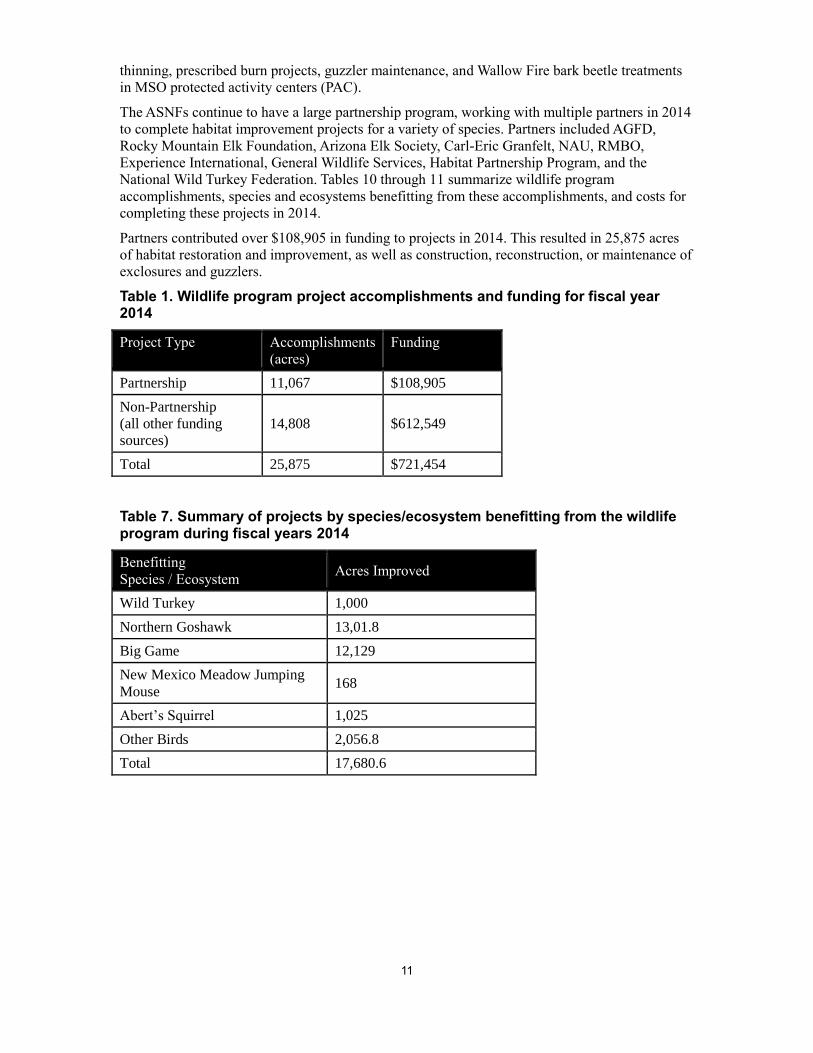
thinning, prescribed burn projects, guzzler maintenance, and Wallow Fire bark beetle treatments
in MSO protected activity centers (PAC).
The ASNFs continue to have a large partnership program, working with multiple partners in 2014
to complete habitat improvement projects for a variety of species. Partners included AGFD,
Rocky Mountain Elk Foundation, Arizona Elk Society, Carl-Eric Granfelt, NAU, RMBO,
Experience International, General Wildlife Services, Habitat Partnership Program, and the
National Wild Turkey Federation. Tables 10 through 11 summarize wildlife program
accomplishments, species and ecosystems benefitting from these accomplishments, and costs for
completing these projects in 2014.
Partners contributed over $108,905 in funding to projects in 2014. This resulted in 25,875 acres
of habitat restoration and improvement, as well as construction, reconstruction, or maintenance of
exclosures and guzzlers.
Table 1. Wildlife program project accomplishments and funding for fiscal year 2014
Project Type Accomplishments
(acres)
Funding
Partnership 11,067 $108,905
Non-Partnership
(all other funding
sources)
14,808 $612,549
Total 25,875 $721,454
Table 7. Summary of projects by species/ecosystem benefitting from the wildlife program during fiscal years 2014
Benefitting
Species / Ecosystem Acres Improved
Wild Turkey 1,000
Northern Goshawk 13,01.8
Big Game 12,129
New Mexico Meadow Jumping
Mouse 168
Abert’s Squirrel 1,025
Other Birds 2,056.8
Total 17,680.6

12
Figure 8. New Mexico meadow jumping mouse.
Figure 9. Habitat for New Mexico meadow jumping mouse along the East Fork of the Little Colorado River.

13
Threatened, Endangered, Proposed, and Sensitive Species (TEPS)
In 2014, the ASNFs had two federally listed threatened, two federally listed endangered, and one
experimental/non-essential terrestrial species: the Mexican spotted owl (T), yellow-billed cuckoo
(T) southwestern willow flycatcher (E), New Mexico meadow jumping mouse (E) (figure 9), and
the Mexican gray wolf, respectively.
In 2014, critical habitat continued to be proposed for the New Mexico meadow jumping mouse
and proposed for yellow-billed cuckoo, with expected designation of critical habitat to occur in
late 2015. Aquatic species are addressed in another section of this report. Mexican gray wolves
are discussed under the Mexican Wolf Reintroduction Program section of this report.
There are currently 22 Forest Service sensitive terrestrial animal species, and 22 Forest Service
sensitive rare plant species occurring on the ASNFs.
Monitoring
Monitoring terrestrial TEPS species during 2014 (table 13) was accomplished through
partnerships and contracts, with the assistance and cooperation of the Arizona Game and Fish
Department’s Bald Eagle Nest Watch program, NAU, and RMBO.
Table 8. Summary of TEPS monitoring completed between 2014
Benefitting
Species / Ecosystem
Number of PACs/PFAs/Nest Sites
Monitored
Mexican Spotted Owl 72
Northern Goshawk 6
Bald Eagle 4
Southwestern Willow Flycatcher 1
Mexican Gray Wolf Reintroduction Program
The ASNFs actively worked with five other state and federal agencies to continue efforts in the
reintroduction of the endangered Mexican gray wolf into the Blue Range Wolf Recovery Area
(BRWRA) in New Mexico and Arizona.
From 2013 through 2014, Mexican gray wolf numbers increased by 30%, with a minimum of 110
wolves counted in Arizona and New Mexico. The field team located 40 wolves on the Apache
portion of the ASNFs. These wolves made up seven packs that are maintaining territories on the
ASNFs in 2014. A pack is composed of at least one adult pair.
One initial release occurred in 2014 on Alpine Ranger District of the ASNFs. No translocations
occurred in 2014. A translocation is defined as when an individual free-ranging wolf is captured
and moved to a location within either the Primary or Secondary Recovery Zone but away from
the site of capture. This includes captured wolves that have been temporarily housed in captivity.
Reports from ranchers and others resulted in confirmation of 16 cases of livestock killed or
injured by wolves on the ASNFs and private holdings in 2013. In 2014, 13 depredations on
livestock were confirmed as wolf-caused. Additional livestock may have been killed by wolves
but either were not found or were found too late to confirm the cause of death. In response to
these problems, the Interagency Field Team conducts hazing on wolves known to kill livestock
and uses other proactive measures to reduce depredations.
Four wolves are known to have died in the wild during 2012, and 7 died in 2013. In 2014, 11 wolf
deaths were documented. All of these mortalities except five were from illegal shooting. The

14
other mortalities were from other causes which may include, but are not limited to, natural deaths,
capture-related mortalities and legal public shooting.
Please report any encounters with wolves to the Interagency Field Team at 1-888-459-9656.
Aquatic Species
The ASNFs include habitat for eleven federally listed,and one candidate aquatic species including
Gila trout, Chiricahua leopard frog, Gila chub, Little Colorado spinedace, Three Forks
springsnail, and narrow-headed gartersnake. In 2014, narrow-headed gartersnake and northern
Mexican gartersnake were listed as threatened species; a final ruling on proposed critical habitat
for these species has not yet been published in the Federal Register. There are currently fourteen
sensitive aquatic species present on the Forests. The ASNFs encompass aquatic habitat within the
Gila, Salt, and Little Colorado River drainages. Aquatic and riparian habitats are a key component
and important asset in managing National Forest System lands.
During FY 2014, ASNFs’ biologists conducted analyses of forest projects that resulted in 5
biological assessments and evaluations written for aquatic species. The Forests requested
concurrence for determinations of “not likely to adversely affect” on 3 projects and requested no
formal consultations on aquatic species. Consultation requests were for landscape restoration,
fence reconstruction and range allotment management projects.
Monitoring
Monitoring aquatic species was accomplished with the assistance and cooperation of range
personnel, partner agencies, and contracts. Crossing internal and agency boundaries to build
understanding and cooperation has been a focal point for the aquatics program. This cooperation
resulted in monitoring being completed multiple times for many threatened, endangered, and
sensitive (TES) aquatic species during the timeframe. Monitoring of Three Forks springsnails,
spikedace, loach minnow, narrow-headed gartersnakes, Apache trout, Gila chub, Chiricahua
leopard frog and Little Colorado spinedace was completed in FY2014. The ASNFs contracted
surveys for loach minnow and their habitat in the Blue River and Chiricahua leopard frog in stock
tanks. Recovery actions included the following: stocking of Chiricahua leopard frog. Removal of
nonnative aquatic species was completed in West Fork Black River, Blue River and Three Forks
springsnail habitats (Figure 3). A joint monitoring effort between USFWS and the Forest to assess
sedimentation in the Blue watershed continued during the fiscal year. This monitoring will be
able to look at trends in fine sediment and how it changes with spring runoff and monsoon rains.

15
Figure 10. Three Forks springsnail habitat work to prevent crayfish infestation.
Overall monitoring is showing that fish populations are rebounding post-Wallow Fire in the Black
and Blue River drainages. Campbell Blue Creek, in the Blue River drainage had extensive
spawning of native fish, and endangered loach minnows were detected for the first time in a
decade (Figure 4).

16
Figure 11. Endangered loach minnow found in Campbell Blue Creek.
The ASNFs have continued a long-term stream temperature monitoring program that started in
2012. As of December 2014, forty-one data loggers have been placed within the the Black, Blue
and Little Colorado River watersheds to monitor stream temperatures year round. This program
will aid in identifying where climate change and increased stream temperatures may be an issue
for native fish, as well as where management actions may be needed. The data will be used for
climate change modelling and predict increases in stream temperature once a few continuous
years of data have been collected. Data from data loggers are downloaded annually and entered
into a national database. The work is part of the Rocky Mountain Research Station stream
temperature monitoring program.
Projects
There were a total of 11 projects completed during the timeframe for TES and other aquatic
species. Projects resulted in 28.6 miles of stream habitat restoration and 48.5 miles of stream
habitat inventoried. Projects included species restoration, habitat restoration and protection, salt
cedar removal, barrier reinstallation post-fire, barrier removals, and inventories. Species
benefiting from these projects include Chiricahua and lowland leopard frogs, Three Forks
springsnail, loach minnow, spikedace, narrow-headed gartersnake, roundtail chub, and Apache
trout.
Partner contributions were over $65,000 in funding and labor for these projects including U.S.
Fish and Wildlife Service, Arizona Game and Fish Department, National Wild Turkey Federation
and Bureau of Reclamation. Many of these projects documented recovery of aquatic species post-
Wallow Fire. Partners and volunteers are vital to accomplishments on the ASNFs.

17
Transportation
One of the desired conditions in the ASNFs 2015 Land Management Plan is “A maintained road
and motorized trail system is in place and provides for safety and access for the use (e.g.,
recreation, minerals, vegetation treatment, fire protection) of the Apache-Sitgreaves NFs.” Road
maintenance and reconstructionare major activities which provide access to support forest
restoration, fire management, and recreation.
The ASNF’s transportation system comprises more than 700 miles of roads designed and
maintained for passenger vehicles and over 2,000 miles of roads designed and maintained for
high clearance vehicles. Approximately 3,000 miles of roads are in storage to be opened for
specific projects (e.g., for commercial product removal) and then placed back in storage at the
completion of the project; these roads are closed to all motorized travel while in storage.
During 2014 the ASNFs performed routine road maintenance on 731 miles of road and
improved/reconstructed 39 miles through force account, contracts and vegetation projects (Table
14). The Forests decommissioned 5 miles of unauthorized user-created routes.
Table 9. Road maintenance and improvement in fiscal year 2014.
Miles of Routine Road Maintenance Miles of Road Improvement
Level 2 Roads
(High Clearance)
Level 3-5 Roads
(Passenger Cars)
Level 2 Roads
(High Clearance)
Level 3-5 Roads
(Passenger Cars)
165 566 6 33
In 2014, $50,000 of restoration funds were used to reconstruct 4.5 miles of NFSR 22. Work
consisted of installing drainage structures, placing riprap at the outlets of grade dips to stabilize
the roadway and minimize sedimentation into the adjacent Morgan Creek, and using a mobile
rock trimmer to utilize the oversized rock along the roadbed to stabilize the native soil surfacing
(Figure AA). The Forests continued to stabilize road drainage structures and install additional
road drainage structures to minimize road damage due to increased precipitation runoff resulting
from the 2011 Wallow Fire.

18
Figure 12. Mobile rock trimmer in use on Pratt Lake Road, March, 2014.
NFSR 249
The purpose of this project was to provide roadway improvements on approximately 17 miles of
roadway to provide for better access from Alpine, Show Low and Lakeside to the Big Lake
Recreation Area, to improve the two watersheds the route traverses by minimizing sedimentation
from aggregate surfacing and un-stabilized ditch lines, and to reduce erosion caused by
undersized drainage structures. The improvements included widening of sections of the roadway
to provide consistent and adequate lane width along the entire route, adding additional guardrail,
replacing obsolete guardrail, replacing and/ or reconstructing existing drainage structures,
stabilizing ditches, paving with asphalt, and installing signage and striping (Figure BA). This
project was made possible by the Central Federal Lands Highway Division (CFLHD) of the
Federal Highway Administration (FHWA), in cooperation with Apache County, Southwestern
Regional Forest Service Office and the Apache-Sitgreaves National Forest. The final construction
costs of this project was $12.5 million.

19
Figure 13. Newly paved NFSR 249, a project that was completed in fiscal year 2014.
NFSR 24, Bear Creek Crossing Stabilization Project
In 2012 a section of Forest Road 24 had to be closed due to a flood event that washed out a large
culvert. The road was impassable because of a 20-25 foot cut through the roadway. In 2014,
Engineering, Watershed and Fisheries personnel on the Apache-Sitgreaves NFs developed a low-
cost plan to repair the washout that would stabilize the cutout drainage by using methods
designed to reduce or repair small headcuts, and that would allow the road to be re-opened. They
constructed a low-water crossing from materials which were readily available at the site,
including 24-36” logs from burned trees, large rocks, and Jersey barriers left over from the
Wallow Fire. The combination of the logs, rip rap and Jersey barriers has stopped the large head
cut from migrating upstream and downstream of the road. Bank cutting and lateral stream
migration have been greatly reduced following the completion of the project, and the stream
banks have begun revegetating (Figure BB). This project was jointly funded with road funds and
watershed funds. The total cost of this project was approximately $60,000. To replace the
washed-out culvert with a new, larger one would have been at least twice the cost, while a bridge
would cost ten times as much.

20
Figure 14. Completed low water crossing on Forest Road 24.
Administrative Facilities
The ASNFs continue to reduce deferred maintenance of administrative facilities through both
large and small projects and to reduce overall facility square footage in an effort to decrease our
maintenance needs. The objective of these projects is to provide, in a cost-effective manner, a safe
and pleasant environment for both employees and the public.
Larger projects completed in fiscal year 2014 include the following:
An underutilized 8-person quarters building was relocated from Springerville RD to the
Strayhorse Administrative Site. It is now heavily utilized by trail crews and fire crews
stationed at the remote administrative site. The existing generator-based power supply
was updated to a solar-powered power supply; the generator now serves as a backup
system.
Backflow preventers were installed at the Springerville District Yard for compliance with
ADEQ and EPA.
Two duplexes were decommissioned at the closed Chevelon Work Center; this will be a
continuing project as funds are made available until all of the no-longer-used buildings
are gone and the site is returned to a more natural state.
Three other no-longer-used buildings which had no commercial value were
decommissioned on the forests.

21
Lands and Minerals
The mission of the ASNFs’ lands and realty management program is to secure and protect
America’s public rights, title, value, and interest in its national forests and grasslands and
authorize a variety of uses on those lands to meet the needs of present and future generations.
Security and protection of the public’s interests in National Forest System (NFS) lands is essential
to the land stewardship and public trust responsibilities of the Forest Service.
Land Exchanges
A land exchange is a discretionary and voluntary real estate transaction that is considered only if
it is in the public interest and is consistent with the Apache-Sitgreaves National Forests Plan. The
ASNFs have captured opportunities to consolidate land ownership patterns to meet the objectives
of the Plan and to improve land management efficiency and to meet the needs of the public.
Thousands of acres of NFS lands have been obtained under various land adjustment authorities.
The land exchange adjustment program has served as an effective tool to acquire desirable non-
federal lands. Exchange of lands is beneficial in several ways. Exchange allows rural
communities to expand and support growth; acquires property with significant natural resource
values such as riparian areas, wildlife and fish habitat, archaeological sites, and rangelands;
provides for expansion of recreational opportunities; and consolidates fragmented ownership
patterns. Furthermore, the acquisition of non-federal lands reduces land boundary maintenance
costs and rights-of-way access to severed NFS lands. The ASNFs receive proposals for private
acquisition of NFS lands in exchange for non-federal lands with higher forest or resource
qualities.
The forest is in the course of processing the Camp Tatiyee Land Exchange (CTLE), which
consists of exchanging one federal (highly encumbered) and 14 non-federal parcels (Figure 15).
The exchange proposes to convey ~344 acres of federal land and acquire ~1719 acres of non-
federal land scattered throughout southern Arizona forests. The forest submitted the Request for
Appraisal Services to the Regional Office in August 2014 prepares to begin the NEPA
Environmental Impact Statement in FY2015.
Lands Special Uses
Lands special uses are a form of authorization for use by individuals, companies, organized
groups, other Federal agencies, and State and local governments. Authorizations have been
granted for uses such as high/low powered electrical transmission lines & facilities, irrigation
impoundment & distribution ditches/pipelines, wireless telecommunication sites, and road rights-
of-ways County, and private road rights-of-way easements. Roughly 30 new special use permits
(SUP) were authorized and roughly 50 SUPs were administered to standard. The Forest continues
to screen proposals to determine appropriate use of NFS lands.
Boundary and Title Management
The 2014 accomplishments were a result of the 2011 Wallow Fire, which damaged and
obliterated many miles of land boundary markers. Approximately 11 miles of the remaining 36.5
miles identified of NFS land boundaries were resurveyed, remarked, and reposted. These surveys

22
Figure 15. CTLE non-federal Rucker parcel to be acquired.
Figure 16. Resurvey, remarking, and reposting of NF Property Boundary as a result of 2011 Wallow Fire.

23
were made possible in cooperation with adjacent private land owners and completed by Arizona
Bureau of Land Management cadastral surveys with rehabilitation and restoration funds. Accurate
marked boundaries enable the Forests to properly manage up to NFS land boundaries adjacent to
other ownerships, reduces & identifies the number of potential unauthorized uses, encroachment,
& title conflicts, protection of established land boundary markers, and clearly identify public
lands for public use in all respective areas.
Encroachment
d. Encroachment typically occurs when NFS property boundaries are not delineated and
maintained to standard or because of faulty land title or erroneous surveys. At times
encroachment is caused by failure to honor existing marked NFS land boundaries. Ranger district
staffs continue their efforts to identify and resolve these cases annually. As a result of completing
11 miles of remarking/reposting NF lands boundaries four new enroachments were discovered
such as off-line fence lines, homestead cabin/corrals, improvements, and junk. Additionally, three
new encroachments were discovered and one encroachment was resolved with improvements
removed. Numerous encroachments still exist forest-wide, but due to capcity and other priority of
work remain unresolved.
Minerals
The forest administered to standard (office review only) five locatable rare picture rock
sandstone. Due to the forest’s priority work load and capacity it did not complete any field
inpections. No leaseable mainerals were authorized. The forest permitted roughly 61 salable
mineral materials (sand, gravel, cinders, and building stone with occasional). Primary users
include private individuals, counties, Arizona Department of Transportation, and internal Forest
Service use for road maintenance.
Forest Products / Resource Management
Fiscal Year 2014 marked a transition for the ASNFs, bringing to a close the White Mountain
Stewardship era and ushering in an accelerated emphasis towards 4FRI Integrated Restoration
Service Contract (IRSC) task orders, conventional timber sales, local agreements and other best
value stewardship contact mechanisms. The forest continued to provide a sustainable supply of
wood products for personal use and other commercial local and regional markets. There were
nine salvage sales sold, four IRTC Stewardship contracts, one 4FRI task order, and one green
timber sale contract. The total volume sold in fiscal year 2014 was 65,698 CCF (Table XX).
Table 10. Commercial timber and personal use and commercial permits sold in FY 2014
Acres Harvested Commercial Timber
Sold (CCF)
Personal Use and Commercial
Permits Sold (CCF)
Total Volume
(CCF)
9,342 54,296 11,402 65,698
A total of 2,549 acres received silvicultural reforestation treatments in fiscal year 2014. This
entire total was located on acres burned by recent and/or past wildfires across ANSF districts.
This activity included artificial tree planting and certification of naturally regenerated acres.
Approximatley 6,821 acres across the ASNFs received timber stand improvement (TSI)
treatments in fiscal 2014. This total includes intermediate thinning of non-commercial or non-
merchantable understory trees, including some sanitation removal and/or pruning of disease-
infected small trees included under TSI service contracts. Timber stand improvements also
occurred as part of overall restoration treatment prescriptions on acres implemented within

24
commercial forest product contracts and/or timber sales in the White Mountain Stewardship or
4FRI contract task orders.
Biomass/Hazardous Fuels Utilization
Forest biomass is both a component of mechanical treatment activities (limbs and tops) and pre-
existing natural fuels. This material represents a considerable portion of forest hazardous fuels
and potential convertible forest product. In 2014, this fiber “by-product” generated during
mechanical treatments continued to observe an increase in utilization removed per acre, driven
primarily by two factors; the availability of a $20/BDT BCAP subsidy through FSA and the
proximity of a cogeneration facility to the treatment areas. Roughly three quarters of the biomass
removed was utilized in local facilities to make commercial wood pellets and electricity.
Additional residual material was left on site to provide woody material for soil nutrient
enhancement and improve watershed condition.
Insects and Diseases
Annual aerial detection survey (ADS) flight data of recent tree mortality attributable to insects is
reported using 5 classes of percent mortality ranging from very light to very severe within each
polygon of insect activity mapped from the air. In 2014, tree mortality due to bark beetle species
was seen in all 5 classes, but the greatest impacts were noted in the Light (4-10% mortality) and
Moderate (11-29% mortality) classes.
Major Insect categories identified by the 2014 ADS mapping flights across the ASNFs, in order of
highest acreages affected:
Bark beetles (9 active beetle species visibly detected in numerous conifer host tree
species) = 109,586 total acres, down somewhat from the 2013 total beetle acres mapped.
However, Douglas-fir and southwestern white pine tree mortality on the Apache NF due
to bark beetles is still high [Moderate and Severe (30-50% mortality) classes], while
spruce mortality increased notably in 2014. The 2014 ADS report for the Apache-
Sitgreaves NF states “The overstory spruce mortality may significantly alter the site-
changing species composition and diameter distribution on the affected lands.”
Defoliators (3 active insect species visibly detected) = 180 acres of conifers; and 1,210
acres of aspen damage which also had drought and secondary biotic/abiotic contributing
factors to aspen decline and/or mortality. This trend is generally down from most recent
previous years.
The effects of the 2011 Wallow Fire across the Apache National Forest continued to become
apparent in subsequent years. Bark beetle outbreaks occurred in live trees of all conifer species
because trees were weakened by the fire, as well as by persistent pathogens, overcrowded forest
conditions in unburned/lightly burned areas, and prolonged drought stress.
The ASNFs employed the use of beetle pheromones to steer adult beetles of target species away
from laying eggs in key mixed-conifer forested areas critical to the local recreation economy and
threatened and endangered species critical habitat. Prompt removal of beetle-infested trees
(imminent mortality) from campgrounds is another important step in the overall success of beetle
control efforts. In 2014, over 1200 beetle-infested/green hazard trees of all species were removed
from numerous campground sites (about 300 acres total) in the Big Lake Recreation Complex.
No other sales of specifically insect-infested trees occurred in 2014, although scattered infested
trees are usually marked for removal during normal forest restoration thinning projects annually.
Local and regional entomologists, foresters, biologists, and recreation staff collaborated with an
Arizona-based young adult conservation corps to provide field labor. Due to the high cost and
tight timeframe of the beetle flight, only a limited number of key acres could be treated. In the
2014 season, 615 acres were successfully treated within developed campgrounds on the

25
Springerville and Alpine Ranger Districts, including the popular Big Lake Recreation Complex.
Another 1,184 acres of Mexican spotted owl (MSO) habitat that survived the Wallow Fire were
also treated.
Beetle population trends were monitored on the forest using other trap type methods of attractant
pheromones also. During the June 2014 Douglas-fir bark beetle flight season approximately 7,350
beetles were collected per trap in a 2-week period at the Big Lake trap site (roughly double the
2013 number collected). This number was slightly less for the rest of the Wallow Fire beetle sites,
but still a significant increase over 2013 numbers. During the August 2014 peak Mountain pine
beetle flight season at trap sites across the Wallow Fire area, approximately 295 beetles were
collected per trap in a 2-week period (roughly 4 times the 2013 number). This work has continued
in 2015 and is expected to be needed for at least another one to three years until the outbreak
subsides. Beetle pheromones pose no harm to humans or the environment when installed
correctly but must be reapplied every year. These projects contribute toward the national Western
Bark Beetle Initiative.
Major Disease categories identified in 2014 by various survey methods across the ASNFs were,
in order of highest known occurrence:
Dwarf Mistletoes (persistent pathogens which do not spread or intensify fast enough for
an annual comparison) = lightly to heavily-infected areas are common across all forest
and woodland types. An estimated 50-60% of all forested acres have some level of
infection. Heavy infection predisposes trees to increased bark beetle attack and mortality.
Root Diseases (also spread slowly so that overall incidence changes little from year to
year) = widely scattered across aspen, mixed-conifer, spruce-fir and pine forest types.
Infection centers occur in pockets and predispose afflicted trees to more rapid mortality
from drought and insect attack.
Stem Rusts, most importantly White Pine Blister Rust (WPBR, an introduced pathogen)
which was first discovered on the ASNFs in 2009. In conjunction with the USFS AZ
Zone Forest Health Pathologist, Northern Arizona University continued in 2014 with a
WPBR mapping and plot monitoring project across the ASNFs to assess the full extent of
this disease’s presence and spread in southwestern white pine. Some seed cone
collections from this host tree species were done as part of an ongoing Region-3 genetic
WPBR resistance testing program.
Unknown ponderosa pine blight on 2,739 acres of the Sitgreaves NF in 2014.
Needle Casts/Needle Scale, isolated occurrences found on ponderosa pine and piñon
pines in the Apache NF in 2014.
Recreation
Visual Quality Objective Compliance bi-annual monitoring ensures Forest standards and
guidelines for visual management is met. The Forest maintains and enhances visual resource
values by including visual quality objectives in resource planning and management activities.
Three projects work plans involving construction and maintenance for major developed
recreation areas have been analyzed.
Blue Vista Overlook resource planning improvements constructed a scenic viewing platform,
with interpretive signs and staining of an existing retaining wall to meet Visual Quality
Objectives. The Landform shaping borrows from the natural established form, line, color, and
texture, and blends in with the natural landscape. Visitors are provided the opportunity to
experience the picturesque vista (Figure 17).

26
Figure 17. Blue Vista Overlook.
At Blackjack Campground, the Forest installed a new vault toilet (Figure 18) and constructed a
new accessible pathway at the group site (Figure 19). This project management activity follows
and repeats forms, lines, colors and textures that are distinctly found in the naturally evolved
landscape character being viewed. There are no evident changes in the size intensity, direction or
pattern of the surrounding landscape character. The project complies with Forest Plan visual
direction of Retention.
Figure 18. Blackjack Campground vault toilet.

27
Figure 19. Blackjack Campground accessible pathway.
At Lewis Canyon Campground, the Forest demolished an outdated outhouse and installed a new
vault toilet (Figure 20).
Figure 20. Lewis Canyon Campground vault toilet.
All Forest replacement and construction of facilities is ongoing with the intent to better
accommodate for accessibility. The facility has a ponderosa pine tree background and because of
the careful architectural design and color selection, the form, line, color, and texture of the toilet
borrow from the natural landscape and do not stand out in the foreground. This is an excellent
example of a recreation structure in the landscape meeting retention.

28
Plan Revision
The ASNFs has completed the Revised Apache-Sitgreaves National Forests Land Management
Plan. The revised plan provides direction to forest specialists on managing the natural resources
across the Forests. The revised plan (LMP), final environmental impact statement (FEIS), and
record of decision have been posted to the forests’ web page at
http://www.fs.usda.gov/goto/ForestPlanFEIS. The Notice of Availability for the FEIS is expected
to be published in September, 2015. For additional information on the revised plan, please visit
the Forests’ website at http://www.fs.usda.gov/asnf or call the Apache-Sitgreaves National Forests
Supervisor’s Office at 928-333-6280.