Unit 5 Part 2 Test PPT - Mrs. Griffin's Science...
28
Unit 5 Part 2 Test PPT
Transcript of Unit 5 Part 2 Test PPT - Mrs. Griffin's Science...

Unit 5 Part 2 Test PPT

Standard 1: Air Masses

Air Mass
An air mass is an immense body
of air that is characterized by
similar temperatures and
amounts of moisture at any given
altitude
When an air mass moves out of
the region over which it formed, it
carries its temperature and
moisture conditions
As it moves, the characteristics
of an air mass change and so
does the weather in the area over
which the air mass moves
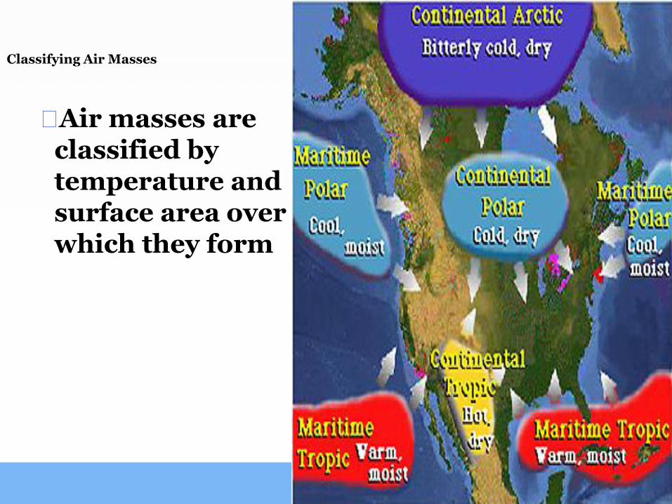
Classifying Air Masses
⬜Air masses are classified by temperature and surface area over which they form

Classifying Air Masses
NAME
P – Polar
LOCATION
High Latitudes
towards the poles
TEMPERATURE
Cold Temps
T – Tropical
Low Latitudes
towards the equator
Warm Temps
C – Continental
Over land mass
Cold or warm,
depending on the
latitude
M – Maritime
Over water
Cold or warm,
depending on the
latitude
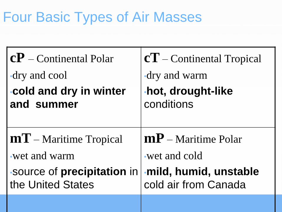
Four Basic Types of Air Masses
cP – Continental Polar
•dry and cool
•cold and dry in winter
and summer
cT – Continental Tropical
•dry and warm
•hot, drought-like
conditions
mT – Maritime Tropical
•wet and warm
•source of precipitation in
the United States
mP – Maritime Polar
•wet and cold
•mild, humid, unstable
cold air from Canada
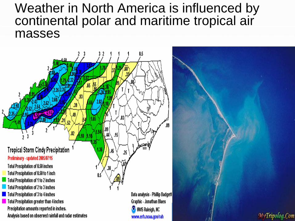
Weather in North America is influenced by continental polar and maritime tropical air masses
Standard 2: Fronts

Fronts
When two air masses
meet
boundary separating
the two air masses.

Warm Front
⬜A warm front – warm air
moves into an area
formerly covered by
cooler air
⬜Warm air glides up over a
cold, dense air mass
⬜Weather Conditions:
Light to moderate rain

Cold Front
Cold air mass moves
into an area occupied
by warmer air.
Weather Conditions:
Thunderstorms
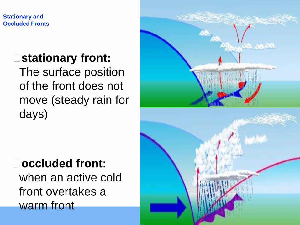
Stationary and
Occluded Fronts
⬜stationary front:
The surface position
of the front does not
move (steady rain for
days)
⬜occluded front:
when an active cold
front overtakes a
warm front
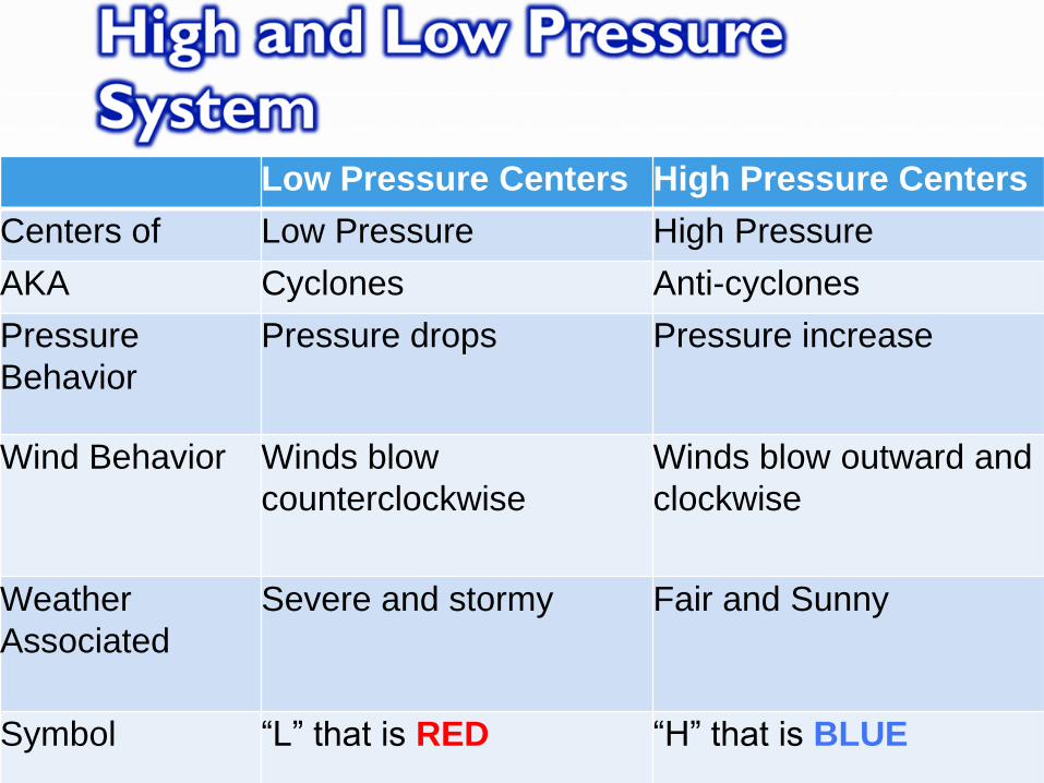
Low Pressure Centers High Pressure Centers
Centers of Low Pressure High Pressure
AKA Cyclones Anti-cyclones
Pressure
Behavior
Pressure drops Pressure increase
Wind Behavior Winds blow
counterclockwise
Winds blow outward and
clockwise
Weather
Associated
Severe and stormy Fair and Sunny
Symbol “L” that is RED “H” that is BLUE

Standard 3: Severe Storms and
Tornadoes
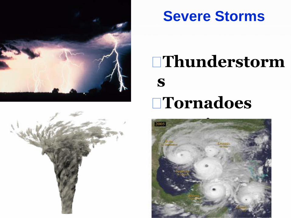
Severe Storms
⬜Thunderstorms
⬜Tornadoes
⬜Hurricanes

Thunderstorms
⬜ Is a storm that generates thunder and lightning
⬜Frequently produces gusty winds, heavy rain, and hail
⬜Associated with cumulonimbus clouds

⬜Lightning: results from the build up and discharge of electric energy between positively (ground) and negatively (clouds) charged area
⬜Thunder: the sound of rapidly expanding gases usually associated with lightning
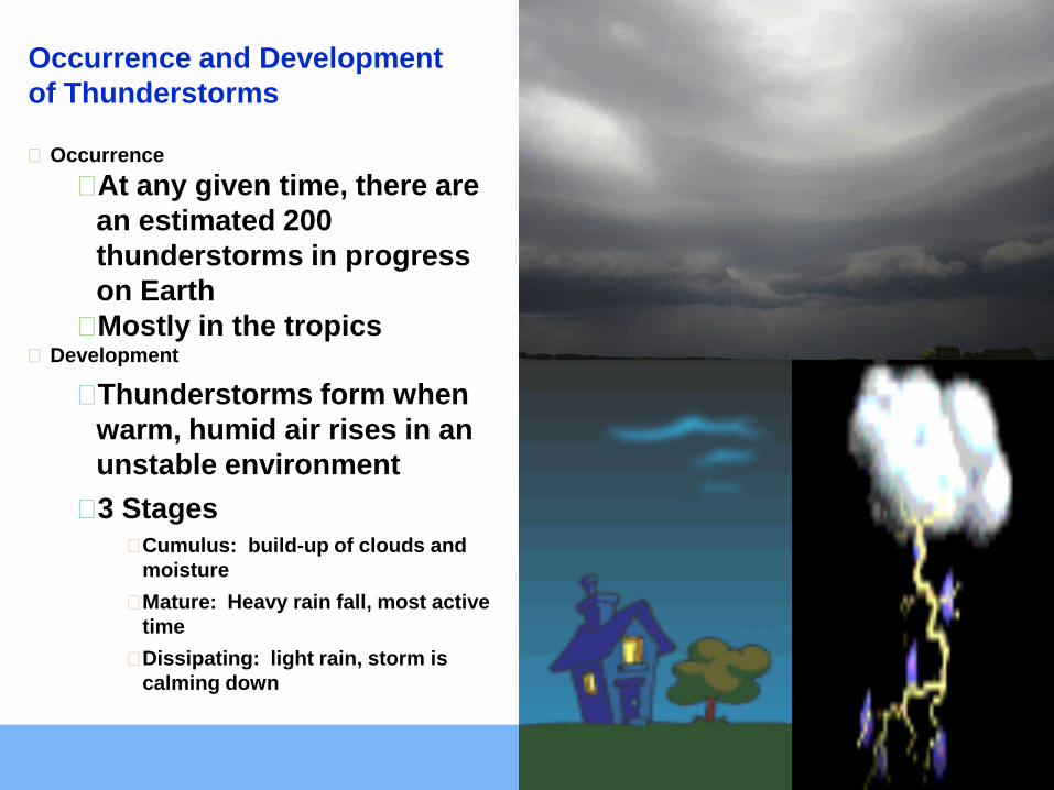
Occurrence and Development
of Thunderstorms
⬜Occurrence
⬜At any given time, there are
an estimated 200
thunderstorms in progress
on Earth
⬜Mostly in the tropics ⬜Development
⬜Thunderstorms form when
warm, humid air rises in an
unstable environment
⬜3 Stages ⬜Cumulus: build-up of clouds and
moisture
⬜Mature: Heavy rain fall, most active
time
⬜Dissipating: light rain, storm is
calming down

Tornadoes
⬜Tornadoes - violent
low pressure windstorms
that take the form of a
rotating column of air
(vortex).
⬜The vortex extends
downward from a
cumulonimbus
cloud producing rain
and hail ⬜Move
counterclockwise
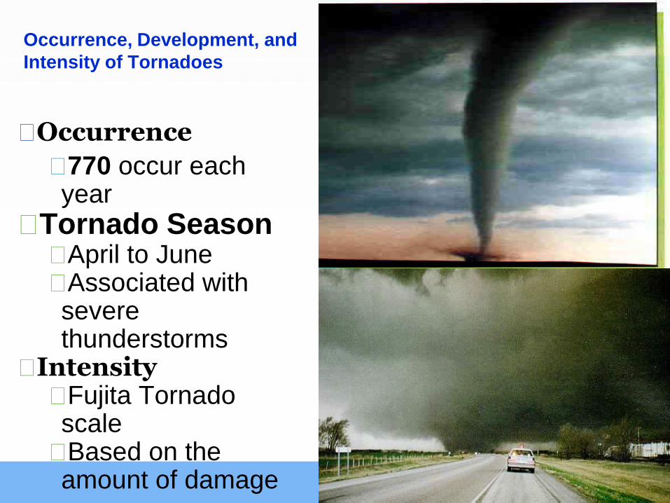
Occurrence, Development, and
Intensity of Tornadoes
⬜Occurrence
⬜770 occur each year
⬜Tornado Season ⬜April to June ⬜Associated with severe thunderstorms
⬜Intensity ⬜Fujita Tornado scale
⬜Based on the amount of damage
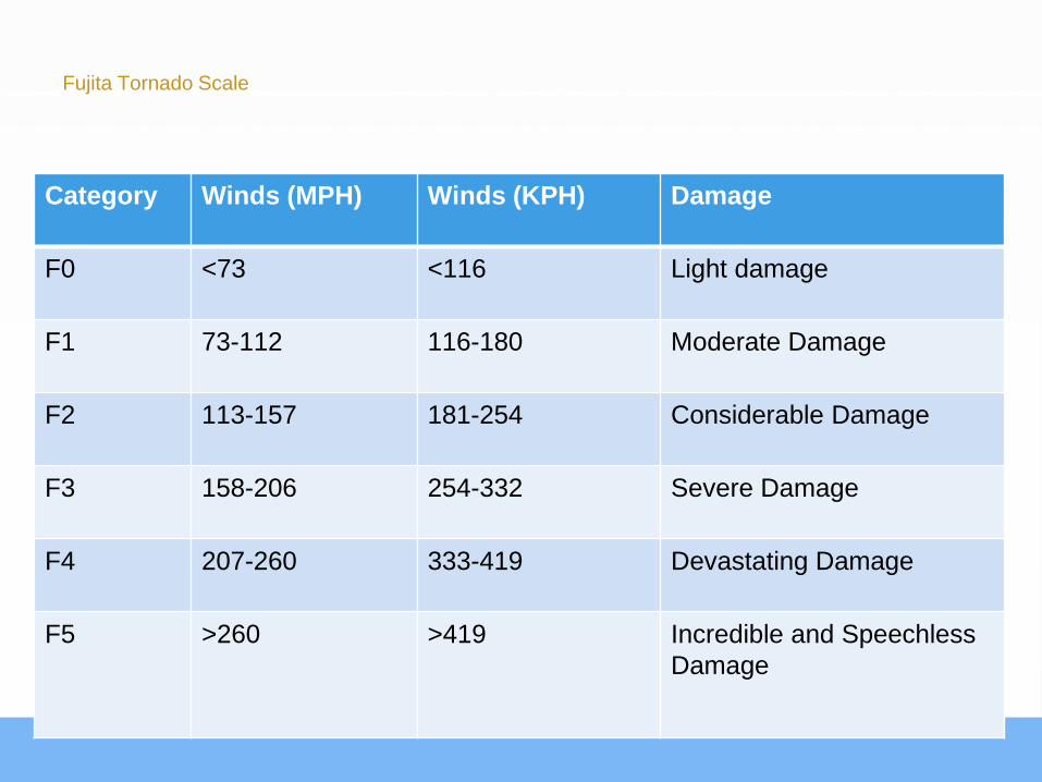
Fujita Tornado Scale
Category Winds (MPH) Winds (KPH) Damage
F0 <73 <116 Light damage
F1 73-112 116-180 Moderate Damage
F2 113-157 181-254 Considerable Damage
F3 158-206 254-332 Severe Damage
F4 207-260 333-419 Devastating Damage
F5 >260 >419 Incredible and Speechless
Damage

Tornado Warnings vs. Watches
⬜Watches : Possibility of a tornado to be
developed in the area
⬜Warning: Tornado has been seen by
people or indicated by radar

Standard 4: Hurricanes

Hurricanes
⬜Whirling tropical cyclones (low
pressure system) producing
winds of at least 119 km per
hour (73 mph)
⬜US – Hurricanes
⬜Pacific – Typhoons
⬜Indian Ocean – Cyclones
⬜Most powerful storm on Earth

Occurrence and
Development of
Hurricanes Occurrence
⬜Form between 5 and 20
degrees north and south latitude
⬜Season: June 1 to November
30th
Development of Hurricanes ⬜Hurricane develop most often in
the late summer when water
temperatures are warm enough
to provide the necessary heat
and moisture to the air
⬜Low Pressure: Spins
counterclockwise

Parts of a Hurricane
Eye: Center of storm,
warmest part, winds
cease, rain ceases
Eye wall: Strongest
winds and rain
Spiral Rain Bands:
extend out from the eye
wall
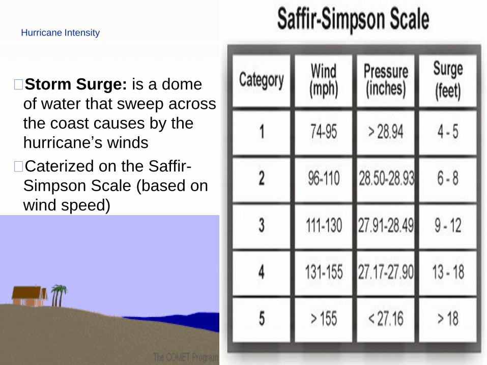
Hurricane Intensity
⬜Storm Surge: is a dome
of water that sweep across
the coast causes by the
hurricane’s winds
⬜Caterized on the Saffir-
Simpson Scale (based on
wind speed)

Hurricane Warning and Watches
⬜Hurricane Watch: could see hurricane related hazards within 48 hours
⬜Hurricane Warning: Could see hurricane winds within 36 hours