UNDERWATER BRIDGE INSPECTION REPORT STRUCTURE NO. 57501 CSAH
11
UNDERWATER BRIDGE INSPECTION REPORT STRUCTURE NO. 57501 CSAH NO. 22 OVER THE RED LAKE RIVER DISTRICT 2 - PENNINGTON COUNTY PREPARED FOR THE MINNESOTA DEPARTMENT OF TRANSPORTATION BY COLLINS ENGINEERS, INC. JOB NO. 5221 (CEI 162)
Transcript of UNDERWATER BRIDGE INSPECTION REPORT STRUCTURE NO. 57501 CSAH

UNDERWATER BRIDGE INSPECTION REPORT STRUCTURE NO. 57501 CSAH NO. 22 OVER THE RED LAKE RIVER DISTRICT 2 - PENNINGTON COUNTY
PREPARED FOR THE MINNESOTA DEPARTMENT OF TRANSPORTATION BY COLLINS ENGINEERS, INC. JOB NO. 5221 (CEI 162)
MINNESOTA DEPARTMENT OF TRANSPORTATION UNDERWATER BRIDGE INSPECTION REPORT SUMMARY:
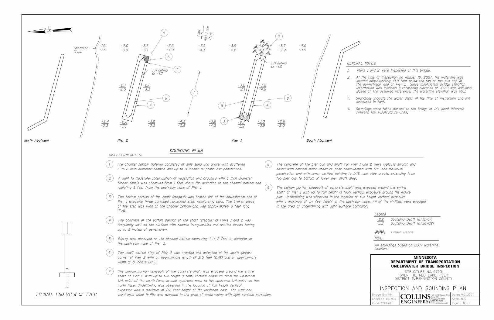
The substructure units inspected at Bridge No. 57501, Piers 1 and 2, were found to be in satisfactory to fair condition with undermining of the footing (base of shaft) and steel pile exposure at Pier 2. The concrete at the base of the piers below water was under reinforced and relatively soft with various spalls, cracks, and failed sections. The extent of the undermining and foundation pile exposure has been reduced at some locations since the previous inspection due to aggredation of the channel bottom material around the substructure units.
INSPECTION FINDINGS:
(A) No design drawings were provided and it is assumed that the piers consist of a steel H-pile bent encased in concrete. The bottom of the encasement exhibited undermining exposing the easternmost steel H-piles at the upstream end of both piers with light surface corrosion. There was vertical face exposure of the footing (base of shaft step out at both piers) around entire perimeter of both piers, with 12 inches (full height) exposure around the upstream nose where the pile exposure was present.
(B) A light to moderate accumulation of organics and/or timber debris was observed
from the waterline to the channel bottom at the upstream end of Pier 1.
(C) The concrete at the base of the pier shafts exhibited widespread irregularities due to section loss, with three corroded horizontal reinforcing bars exposed at the downstream end of Pier 1, as well as with cracks and areas of soft concrete at both piers.

RECOMMENDATIONS: (A) The extent of undermining and foundation pile exposure has been reduced since the
last inspection, so based on the present state of things and the scour stable (low risk) rating for the bridge, it is only recommended that future inspections particularly monitor the undermining and pile exposure.
(B) Reinspect the submerged substructure units at the normal maximum recommended
(NBIS) interval of five (5) years.
MINNESOTA DEPARTMENT OF TRANSPORTATION UNDERWATER BRIDGE INSPECTION 1. BRIDGE DATA
Bridge Number: 57501
Feature Crossed: Red Lake River
Feature Carried: CSAH No. 22
Location: District 2 - Pennington County
Bridge Description: The bridge superstructure consists of three spans of multiple concrete box beams, which are supported by two concrete abutments and two concrete encased H-pile bent piers (assumed from field observations). The piers are numbered 1 and 2 starting from the south end of the bridge.
2. INSPECTION DATA
Professional Engineer Diver: Bradley A. Syler, P.E., S.E.
Dive Team: John J. Loftus, Valerie Roustan
Date: August 18, 2007
Weather Conditions: Sunny, 69° F
Underwater Visibility: 4.0 feet
Waterway Velocity: 1.5 f.p.s.
3. SUBSTRUCTURE INSPECTION DATA
Substructure Inspected: Piers 1 and 2.
General Shape: Field observations suggest that the piers are steel H-pile bent piers encased in a slender concrete shaft that steps out in a rectangular fashion (like a footing) at its base.
Maximum Water Depth at Substructure Inspected: Approximately 4.0 feet.
4. WATERLINE DATUM
Water Level Reference: The top of the pier bridge seat on the west side of Pier 1.
Water Surface: The waterline was approximately 10.9 feet below reference. Assumed Waterline Elevation = 89.1 feet.
5. NBIS CODING INFORMATION (Minnesota specific codes are used for 92B and 113)
Item 60: Substructure: Code 5
Item 61: Channel and Channel Protection: Code 5
Item 92B: Underwater Inspection: Code B/08/07
Item 113: Scour Critical Bridges: Code I/94
Bridge is scour critical because abutment or pier foundation is rated as unstable due to observed scour at bridge site. Yes X No
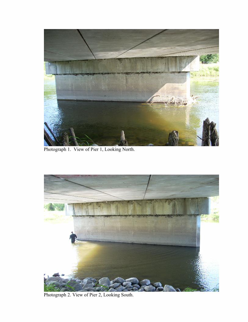
Photograph 1. View of Pier 1, Looking North.
Photograph 2. View of Pier 2, Looking South.


MINNESOTA DEPARTMENT OF TRANSPORTATION OFFICE OF BRIDGES AND STRUCTURES DAILY DIVING REPORT INSPECTORS: Collins Engineers, Inc. DATE: August 18, 2007 ON-SITE TEAM LEADER: Daniel G. Stromberg, P.E. BRIDGE NO: 57501 WEATHER: Sunny, 69° F WATERWAY CROSSED: Red Lake River DIVING OPERATION: X SCUBA SURFACE SUPPLIED AIR
OTHER PERSONNEL: John J. Loftus, Valerie Roustan EQUIPMENT: Scuba, Probe Rod, Lead Line, Camera, U/W Light, Scraper, Sounding Pole, TIME IN WATER: 11:00 a.m. TIME OUT OF WATER: 11:40 a.m.
WATERWAY DATA: VELOCITY 1.5 f.p.s.
VISIBILITY 4.0 feet
DEPTH 4.0 feet maximum at Pier 1 ELEMENTS INSPECTED: Piers 1 and 2 REMARKS: The concrete of the pier cap and shaft for Piers 1 and 2 was typically smooth and sound, with random minor areas of poor consolidation with ¼ inch maximum penetration, and with minor vertical hairline to 1/16 inch wide cracks extending from the top of the pier cap to bottom of lower pier shaft step. The bottom portion of the shaft was broken off at the downstream end of Pier 1 exposing three corroded horizontal steel reinforcing bars. The shaft bottom step of Pier 2 was cracked and detached at the southeastern corner of Pier 2. The bottom of shaft step out was exposed around the entire shaft of both piers with up to full height (1 foot) vertical exposure, around the upstream end / nose of both piers, Undermining was observed in the location of full height vertical exposure where the easternmost steel H-piles were exposed with light surface corrosion. There was a light to moderate accumulation of debris and timber drift at the upstream end of Pier 1. FURTHER ACTION NEEDED: YES X NO

The extent of undermining and foundation pile exposure has been reduced since the last inspection, so based on this current condition and the scour stable (low risk) rating for the bridge, future inspections need only particularly monitor the undermining and pile exposure. Reinspect the submerged substructure units at the normal maximum recommended (NIBIS) interval of five (5) years.
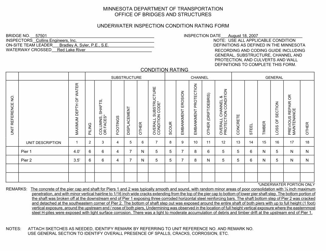
MINNESOTA DEPARTMENT OF TRANSPORTATION OFFICE OF BRIDGES AND STRUCTURES UNDERWATER INSPECTION CONDITION RATING FORM BRIDGE NO. 57501 INSPECTION DATE August 18, 2007 INSPECTORS Collins Engineers, Inc. NOTE: USE ALL APPLICABLE CONDITION ON-SITE TEAM LEADER Bradley A. Syler, P.E., S.E. DEFINITIONS AS DEFINED IN THE MINNESOTA WATERWAY CROSSED Red Lake River RECORDING AND CODING GUIDE INCLUDING
GENERAL, SUBSTRUCTURE, CHANNEL AND PROTECTION, AND CULVERTS AND WALL DEFINITIONS TO COMPLETE THIS FORM.
CONDITION RATING
SUBSTRUCTURE
CHANNEL
GENERAL
UN
IT R
EFE
RE
NC
E N
O.
MA
XIM
UM
DE
PTH
OF
WA
TER
P
ILIN
G
CO
LUM
NS
, SH
AFT
S,
OR
FA
CE
S*
FOO
TIN
GS
DIS
PLA
CE
ME
NT
OTH
ER
O
VE
RA
LL S
UB
STR
UC
TUR
E
CO
ND
ITIO
N C
OD
E*
SC
OU
R
EM
BA
NK
ME
NT
ER
OS
ION
EM
BA
NK
ME
NT
PR
OTE
CTI
ON
OTH
ER
(DR
IFT/
DE
BR
IS)
OV
ER
ALL
CH
AN
NE
L &
P
RO
TEC
TIO
N C
ON
DIT
ION
CO
NC
RE
TE
STE
EL
TIM
BE
R
LOS
S O
F S
EC
TIO
N
PR
EV
IOU
S R
EP
AIR
OR
M
AIN
TEN
AN
CE
OTH
ER
UNIT DESCRIPTION
1
2
3
4
5
6
7
8
9
10
11
12
13
14
15
16
17
18
Pier 1
4.0’
6
6
4
7
N
5
5
7
8
6
5
5
6
N
5
N
N
Pier 2
3.5’
6
6
4
7
N
5
5
7
8
N
5
5
6
N
5
N
N
*UNDERWATER PORTION ONLY REMARKS: The concrete of the pier cap and shaft for Piers 1 and 2 was typically smooth and sound, with random minor areas of poor consolidation with ¼ inch maximum
penetration, and with minor vertical hairline to 1/16 inch wide cracks extending from the top of the pier cap to bottom of lower pier shaft step. The bottom portion of the shaft was broken off at the downstream end of Pier 1 exposing three corroded horizontal steel reinforcing bars. The shaft bottom step of Pier 2 was cracked and detached at the southeastern corner of Pier 2. The bottom of shaft step out was exposed around the entire shaft of both piers with up to full height (1 foot) vertical exposure, around the upstream end / nose of both piers, Undermining was observed in the location of full height vertical exposure where the easternmost steel H-piles were exposed with light surface corrosion. There was a light to moderate accumulation of debris and timber drift at the upstream end of Pier 1.
NOTES: ATTACH SKETCHES AS NEEDED, IDENTIFY REMARK BY REFERRING TO UNIT REFERENCE NO. AND REMARK NO.
USE GENERAL SECTION TO IDENTIFY OVERALL PRESENCE OF SPALLS, CRACKS, CORROSION, ETC.