BRIDGE # CSAH 29 over MAPLE RIVER - dot.state.mn.us · BRIDGE 7190 CSAH 29 OVER MAPLE RIVER...
16
2017 UNDERWATER BRIDGE INSPECTION REPORT BRIDGE # DISTRICT: COUNTY: CITY/TOWNSHIP: Date of Inspection: Equipment Used: Inspected By: Report Written By: Report Reviewed By: Final Report Date: 7190 CSAH 29 over MAPLE RIVER District 7 Blue Earth MAPLETON 12/01/2016 Forsyth, Roy Roy Forsyth County Highway Agency Owner: Minnesota STATE:
Transcript of BRIDGE # CSAH 29 over MAPLE RIVER - dot.state.mn.us · BRIDGE 7190 CSAH 29 OVER MAPLE RIVER...

2017 UNDERWATER
BRIDGE INSPECTION REPORT
BRIDGE #
DISTRICT: COUNTY: CITY/TOWNSHIP:
Date of Inspection:
Equipment Used:
Inspected By:
Report Written By:
Report Reviewed By:
Final Report Date:
7190
CSAH 29 over MAPLE RIVER
District 7 Blue Earth MAPLETON
12/01/2016
Forsyth, Roy
Roy Forsyth
County Highway AgencyOwner:
MinnesotaSTATE:

UNDERWATER SUMMARY 3
UNDERWATER INSPECTION 4
UNDERWATER INSPECTION PROCEDURES 6
STRUCTURE INVENTORY 7
ELEMENTS 8
PICTURES 11
DRAWINGS 15
TABLE OF CONTENTS
PAGE NUMBER

Contractor:
(A) Remove timber debris.(B) Reinspect the submerged substructure units at the normal maximum recommended (NBIS) interval of sixty (60) months.
Collins Engineers, Inc.
9687Contractor Job Number:
RECOMMENDATIONS
REPORT SUMMARY
UNDERWATER INSPECTION
The steel piles exhibited loss of coating with light surface corrosion from 2 ft above the waterline to the channel bottom. There was a heavy accumulation of timber debris at the upstream fascia extending across the full width of the channel.
(A) The channel bottom material consisted of 6 inch diameter and smaller riprap.(B) The furthest south piles on Piers 1 and 2 were cast in place steel piles with paint coating intact from the cap to 2 foot above the waterline and 10 percent loss of coating from 2 foot above the waterline to the channel bottom.(C) There was an accumulation of timber debris consisting of 2 foot diameter and smaller logs from the channel bottom to 6 foot above the waterline extending across the full width of the channel at the upstream fascia.
INSPECTION FINDINGS
Page 3 of 16

Top of cap at upstream nose of Pier 1. Water Level Reference:
WATERLINE DATUM
Waterline Elevation (feet):
The waterline was located 10.2 ft below the reference. Description:
1027.3
4.
Piers 1 and 2Substructure(s) Inspected:
SUBSTRUCTURE INSPECTION DATA
General Shape:
7.4Maximum Water Depth at Substructure(s) Inspected (feet):
Pier 1 consists of 8 octagonal concrete piles with 2 steel CIP steel piles at the south end. Pier 2 consists of 5 octagonal concrete piles with 2 steel CIP steel piles at the south end.
Code:Item 62: Culvert:
7
Y 48 12/2016Code:Item 92B: Underwater Inspection:
Code:
(Minnesota specific codes are used for 92B and 113)
NBIS CODING INFORMATION5.
Item 60: Substructure:
Item 61: Channel and Channel Protection:
6Code:
District 7District:
CSAH 29
County:
The bridge consists of a 3 span post tension concrete girder bridge founded on 2 reinforced concrete abutments and 2 pile bents.
Bridge Description:
007 - Blue Earth
Facility Carried:
BRIDGE DATA1.
UNDERWATER INSPECTION
Bridge #:
MAPLE RIVERFeature Intersected:
7190
Underwater Visibility (feet):
Cloudy 30FWeather Conditions:
1
3.
1Waterway Velocity (ft/sec):
12/01/2016
Professional Engineer/Team Leader:
INSPECTION DATA2.
Roy Forsyth
Date of Underwater Inspection:
Marc SternInspection Diver:
Page 4 of 16

Scour 1885 EA 1
205 Reinforced concrete column 13 EA 13
STRUCTURAL ELEMENT CONDITION RATING
Conditions
6.
R
Bridge is scour critical because abutment or pier foundation is rated as unstable due to observed scour at bridge site.
Item 113: Scour Critical Bridge: Code:
No (Mark your selection with an X)Yes X
202
CS3 CS4
Steel column 44 EA
CS2ELEM # Unit CS1Element Description Quantity
Page 5 of 16

The routine underwater inspection of Bridge 7190 (CSAH 29 over Maple River) was completed on December, 1, 2016. Theunderwater inspection was conducted from shore. The inspection was conducted by a team consisting of a PE-Diver with a valid
MnDOT Team leader certification, a backup diver and a dive tender. The inspection utilized commercial dive equipment andtechniques (SSA and/or SCUBA) in accordance with OSHA regulations. Profiles were taken along the upstream and downstreamfaces of the bridge and around the periphery of substructure units to determine the presence, location and area of scour. The bridge elements inspected consisted of 4 steel CIP piles and 13 concrete piles. Inspection procedures followed FHWA guidance and the MnDOT Bridge and Structure Inspection Program Manual with channel bottom probing to search for bottom of foundations. Theroutine underwater inspection frequency is recommended to remain at 60 months based on those findings and risk factors. Also, inspection procedures should continue to follow the above approach and standard guidance with 100% Level I and 10% Level II intensity efforts.
INSPECTION PROCEDURES
UNDERWATER INSPECTION
Page 6 of 16

Spec. Feat.Pier Foundation (Material/Type)
1 - CONCCantilever ID
+ W A T E R W A Y +Number of Spans Historic Status
3 - FTG PILE
Underwater 60Culvert Type 3 - FTG PILE
Pinned Asbly.
12/01/2016
Barrel Length
93.0 ft. Navigation Control
Waterway Opening (sf.) 1620Structure Length
ft. Year Painted
0 - No nav. control on waterwayDeck Width (Out-to-Out) 31.7
+ P A I N T +
APPR: 0 TOTAL:5 - Not eligible
MAIN: 3
Main Span Length 31.0 ft.Drainage Area (sq. mi.)
B R I D G E D A T A +Main Span Detail
1 - MEETS STANDARDS+ M I S C.
Appr. Span Type Structure Flared
GR Termini 0 - SUBSTANDARD
Appr. Guardrail
Main Span Type 5 - Prestress or Precast Median Width On Bridge
ft. Bridge Railing 0 - SUBSTANDARD
1 - MEETS STANDARDS
Main Span Design 11 - Channel Span
ft. GR Transition
Skew 0
Y/N Freq Date
Abutment Foundation (Material/Type)
1 - CONC Frac. Critical
D E P T H I N S P. +Appr. Span Design
0 - No flare+ I N
Appr. Span Detail Field Conn. ID
Parallel Structure N - No parallel structure
Pier Protection
0 - Not Required
Rating Date 04/29/20132745 sq. ft. Traffic
ft. 50B. Rt 0.00Sidewalk Width 50A. Lt 0.00
Roadway Area (Curb-to-Curb)
Posted Load 0 - Not Required
PostingStructure Area (Out-to-Out) 2948 sq. ft.
DBL:VEH: SEMI:
Rt 42 ARail Type Lt 42 C N - N/AN - N/A B N - N/A
N - Not Applicable Overweight Permit CodesCurb Height Lt
ft. Horizontal 1 - Object Markers
0.92 ft. Vertical0.92 ft. Rt
Wear Surf Install Year
sq. ft. Nav. Vert. Lift Bridge Clear. (ft.)
R - CRIT - MONITOR
Year 2003Primer Type MN Scour Code
Painted Area
Unsound Paint % Nav. Clr. (ft.)Deck Material 1 - Concrete Cast-in-Place 0.0Wear Surf Type 6 - Bituminous
Vert. 0.0 Horiz.
S I G N S +Operating Rating 2 - HS TRUCK
0 - None + B R I D G E
Inventory Rating 2 - HS TRUCK 20.4
34.0Deck Rebars Install Year
Deck Rebars
Finish TypeWear Course/Fill Depth 0.08 ft.
0 - None
Design Load 4 - H 20
+ C A P A C I T Y R A T I N G S +Deck Membrane
43 ° 53
Inspector Name Forsyth, Roy
Latitude Control Section (TH Only) Status' 55.56 ''
2 - 2-way traffic
Routine Inspection Frequency 24
Sect., Twp., Range
1.3 MI W OF JCT CR 192 Level of Service 1 - MAINLINE
- 26W Roadway Type18 - 105N
Detour Length 6.0 mi.R A T I N G S +
Custodian 02 - County Highway Agency
Owner 02 - County Highway AgencyDeck 5 Unsound
Deck %
C O N D I T I O N° 0 '
A - Open
Longitude 94 002+00.980 + N B I 13.62 '' Reference Point
23 Crew
+ I N S P E C T I O N +
Agency Br. No. 47
District 07
Bridge Match ID (TIS) 0 Userkey
CSAH 29 over MAPLE RIVER
Minnesota Structure Inventory Report
Bridge ID: 7190
+ G E N E R A L + + R O A D W A Y +
Date: 01/31/2017
Sufficiency Rating 81.8Roadway Name or Description
29
City
Routine Inspection Date 12/05/2016
Desc. Loc.
Township 07016 - MAPLETON CSAH 29
Number
NRoadway O/U Key Route On StructureMaint. Area Structurally Deficient
NRoute Sys 04 - CSAHCounty 007 - Blue Earth Functionally Obsolete
Lanes
Waterway Adequacy 8Max. Vert. Clear.
ft.Legislative District 24Bft.Potential ABC 2 - N/A ft.
ft.On - Off System Roadway Width 29.50 ft.
Vertical Clearance ft.1 - ON
Underclearances N
Service On 1 - Highway Appr. Surface Width+ S A F E T Y F E A T U R E S +
5 - Waterway Bridge Roadway Width 29.5
35.0 ft.
Service Under
ft.
ft. Approach Alignment 6Horizontal Clear.
ft.
ft.+ S T R U C T U R E + Lateral Clearance
HCADT ADTT6
Year Built 1956
MN Year Reconstructed Functional Class
%Channel 7
Substructure
0Superstructure 5
ON 2 UNDER
316 YEAR 2008BMU Agreement ADT
Structure Evaluation 5If Divided
D I M E N S I O N S +Bridge Plan Location 3 - COUNTY
Deck Geometry 6NB-EB SB-WBDate Opened to Traffic
+ R D W Y
FHWA Year Reconstructed
MN Temporary Status
07 - Rural - Major CollectorCulvert N
A P P R A I S A L R A T I N G S ++ N B I
Page 7 of 16

County:
City:
Township:
Township:Section: Range:
Span Type:
NBI Deck: Super: Sub: Chan: Culv:
Appraisal Ratings - Approach: Waterway:
Required Bridge Signs - Load Posting:
Horizntal:
Traffic:
Vertical:
MN Scour Code:
Open, Posted, Closed:
Location:
Route:
Control Section:
Local Agency Bridge Nbr.:
Ref. Pt.:
Maint. Area:
Length:
Deck Width:
Rdwy. Area/ Pct. Unsnd:
Paint Area/ Pct. Unsnd:
Culvert:
Blue Earth
07016 - MAPLETON
105N18 26W
5 - Prestressed Concrete 2 -Stringer/Multi-beam or Girder
5 5 6 7 N
6 8
0 - Not Required
1 - Object Markers
0 - Not Required
N - Not Applicable
R - CRIT - MONITOR
1.3 MI W OF JCT CR 192
04 - CSAH 29
23
002+00.980
93.0
31.7
2745 sq. ft. / %
sq. ft. / %
N/A
A - Open
ft.
ft.
Postings:List:
MINNESOTA BRIDGE INSPECTION REPORT
02/01/2017
BRIDGE 7190 CSAH 29 OVER MAPLE RIVER
Unofficial Structurally Deficient N
NUnofficial Functionally Obsolete
Unofficial Sufficiency Rating 81.8
ELEMNBR ELEMENT NAME INSP. DATE QUANTITY
QTYCS 1
QTYCS 2
QTYCS 3
QTYCS 4REPORT TYPE
Reinforced Concrete Top Flange 01/31/2017 2948 SF 2948 0 0 016 Underwater
12/05/2016 2948 SF 2948 0 0 0Routine
Notes: [2016] Migrator assumed CS1.
510 - Wearing Surfaces 2745 SF 2690 0 55 0
Notes: Bituminous Overlay Notes: 2004 - Mill & 2 inch overlay this year.2012, 2014, 2016 - Bituminous overlay has numerous cracks.
Underwater 01/31/2017
2745 SF 2690 0 55 0Routine 12/05/2016
Reinforced Concrete OpenGirder/Beam
01/31/2017 928 LF 473 421 34 0110 Underwater
12/05/2016 928 LF 473 421 34 0Routine
Notes: [2016] Migrator estimated the quantity of the channel spans. Verify the quantity by multiplying the number of vertical beams (2 beamsper precast section) by the deck length.Rebars exposed on one span, east side. Longitudinal cracking along bottom side of several beams.2006 - Increased spalling on west span.2010 - Center span has 2 channels with spalling and rebar exposed.2012 - West span has one channel with exposed rebars.2014 - Spalling and corrosion of beams in all spans. West span 30' exposed rebar with section loss, Center span 2 beams with 8' exposed rebarand east span 2' of exposed rebars.2016 - 10 Channel spans @ 92;-2" = 922 LF
Steel Column 01/31/2017 4 EA 0 4 0 0202 Underwater
12/05/2016 4 EA 0 4 0 0Routine
Notes: 2010, 2012, 2014, 2016 Paint failing
515 - Steel Protective Coating 160 SF 80 0 80 0
Notes: 2016 - 12-3/4" piles = 3.33 SF/LF = 4 x 3.33 x 12' exposed = 160 SF. Approximatelt 50% rust.
Underwater 01/31/2017
160 SF 80 0 80 0Routine 12/05/2016
Reinforced Concrete Column 01/31/2017 13 EA 0 13 0 0205 Underwater
12/05/2016 13 EA 0 13 0 0Routine
Notes: Minor cracking.
Reinforced Concrete Abutment 01/31/2017 79 LF 46 33 0 0215 Underwater
12/05/2016 79 LF 46 33 0 0Routine
Notes: Minor cracking.2014 - Concrete piling exposed at east abutment.Wingwall notes: Minor cracking.2016 - 62'+ 4 x 4.25 = 79'
Page 8 of 16
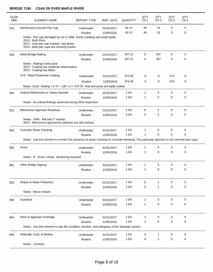
Reinforced Concrete Pier Cap 01/31/2017 62 LF 49 13 0 0234 Underwater
12/05/2016 62 LF 49 13 0 0Routine
Notes: Pier cap damaged by ice in 1959. Some cracking and small spalls.2010 - Both Piers2012 - East pier cap cracked. See photo.2014 - Both pier caps are showing cracks.
Metal Bridge Railing 01/31/2017 187 LF 0 187 0 0330 Underwater
12/05/2016 187 LF 0 187 0 0Routine
Notes: Railings need paint.2012 - Coating has moderate deterioration.2014 - Coating has failed.
515 - Steel Protective Coating 374 SF 0 0 374 0
Notes: 2016 - Railing = 2'-0'' = 187 x 2 = 374 SF. Rail and posts are badly rusted.
Underwater 01/31/2017
374 SF 0 0 374 0Routine 12/05/2016
Critical Deficiencies or Safety Hazards 01/31/2017 1 EA 1 0 0 0800 Underwater
12/05/2016 1 EA 1 0 0 0Routine
Notes: No critical findings observed during 2016 inspection.
Bituminous Approach Roadway 01/31/2017 2 EA 0 2 0 0822 Underwater
12/05/2016 2 EA 0 2 0 0Routine
Notes: 2004 - Mill and 2" overlay2012 - Bituminous approaches patched, but still cracked.
Concrete Shear Cracking 01/31/2017 1 EA 1 0 0 0883 Underwater
12/05/2016 1 EA 1 0 0 0Routine
Notes: Use this element to monitor the presence of shear cracking on concrete elements. Pay particular attention to the concrete pier caps.
Scour 01/31/2017 1 EA 1 0 0 0885 Underwater
12/05/2016 1 EA 1 0 0 0Routine
Notes: R - Scour critical. Monitoring required.
Other Bridge Signing 01/31/2017 1 EA 1 0 0 0891 Underwater
12/05/2016 1 EA 1 0 0 0Routine
Slopes & Slope Protection 01/31/2017 1 EA 0 1 0 0892 Underwater
12/05/2016 1 EA 0 1 0 0Routine
Notes: Minor erosion.
Guardrail 01/31/2017 1 EA 1 0 0 0893 Underwater
12/05/2016 1 EA 1 0 0 0Routine
Deck & Approach Drainage 01/31/2017 1 EA 1 0 0 0894 Underwater
12/05/2016 1 EA 1 0 0 0Routine
Notes: Use this element to rate the condition, function, and adequacy of the drainage system.
Sidewalk, Curb, & Median 01/31/2017 1 EA 0 1 0 0895 Underwater
12/05/2016 1 EA 0 1 0 0Routine
Notes: Cracked.
ELEMNBR ELEMENT NAME INSP. DATE QUANTITY
QTYCS 1
QTYCS 2
QTYCS 3
QTYCS 4
BRIDGE 7190 CSAH 29 OVER MAPLE RIVER
REPORT TYPE
Page 9 of 16

ELEMNBR ELEMENT NAME INSP. DATE QUANTITY
QTYCS 1
QTYCS 2
QTYCS 3
QTYCS 4
BRIDGE 7190 CSAH 29 OVER MAPLE RIVER
REPORT TYPE
Protected Species 01/31/2017 1 EA 1 0 0 0900 Underwater
12/05/2016 1 EA 1 0 0 0Routine
Notes: 2016 - The presence of protected species living on this structure was observed.
General Notes:
Inspector's Signature Reviewer's Signature
2008 - Generally the same conditions exist as previous inspections indicate.2010 - Generally the same conditions exist as previous inspections indicate.2012 - Pre-cast channels continue to deteriorate.2012 - Erickson Engineering made an inspection 12-04-2012 for new load rating.2014, 2016 - Ends of precast channels cracked and spalling.
58. Deck NBI:
36A. Brdg Railings NBI:
36B. Transitions NBI:
36C. Appr Guardrail NBI:
36D. Appr GuardrailTerminal NBI:
59. Superstructure NBI:
60. Substructure NBI:
61. Channel NBI:
62. Culvert NBI:
71. Waterway Adeq NBI:
72. Appr RoadwayAlignment NBI:
2014 - Bituminous overlay has numerous cracks.
Turned down ends.
2016 - Precast channels have rebars exposed with longitudinl cracking along bottom of several beams.
2016 - Rating revised to reflect bridge on a curve and bottom of a hill.
Page 10 of 16

Photo 1 - Overall looking north.
Photo 2 - West Abutment looking west.
Pictures
Page 11 of 16

Pictures
Photo 3 - Pier 1 looking east.
Photo 4 - Pier 2 looking west.
Page 12 of 16

Pictures
Photo 5 - East Abutment looking east.
Photo 6 - Overall looking south.
Page 13 of 16

Pictures
Photo 7 - Typical concrete and steel condition near waterline at south end of Pier 1 looking east.
Page 14 of 16

Page 15 of 16

W.L. El. 1027.3
Legend
Channel Bottom per 2016 Inspection
1030.0
1020.01020.0
1030.0
1040.0 1040.0
1030.0
1020.01020.0
1030.0
1040.0 1040.0
UPSTREAM FASCIA PROFILE
DOWNSTREAM FASCIA PROFILE
DISTRICT 7, BLUE EARTH COUNTY
OVER THE MAPLE RIVER
STRUCTURE NO. 7190
UPSTREAM AND DOWNSTREAM FASCIA PROFILES
MJS
RAF
9687
12/1/2016
1"=10'
31'-1" 31'-•"31'-•"
East Abutment
~ Pier 1~ Pier 2
West Abutment
W.L. El. 1027.3
31'-1" 31'-•"31'-•"
East Abutment
~ Pier 1~ Pier 2
West Abutment
UNDERWATER BRIDGE INSPECTION
DEPARTMENT OF TRANSPORTATION
MINNESOTA
Checked By: Scale:
Figure No.: 2
Drawn By: Date:
www.collinsengr.com
(651) 646-8502
St. Paul, MN. 55104
Suite 206
1599 Selby Ave.
Project: Page 16 of 16