Uncertainty and bathymetric DEM - GEBCO
12
5/10/15 GEBCO Science Day 2015 1 / 12 Uncertainty and bathymetric DEM Developing an Open Source QGIS solution T. Schmitt (SHOM) C. Penard (NOVELTIS) J. Waddle (NOVELTIS)
Transcript of Uncertainty and bathymetric DEM - GEBCO
5/10/15GEBCO Science Day 2015 1 / 12
Uncertainty and bathymetric DEM
Developing an Open Source QGIS solution
T. Schmitt (SHOM)
C. Penard (NOVELTIS)
J. Waddle (NOVELTIS)

5/10/15GEBCO Science Day 2015 2 / 12

5/10/15GEBCO Science Day 2015 3 / 12
Problematic� Generally limited information (if none) is conveyed concerning uncertainty of the DEM (global or at the cell level)
� Multiple sources of data needed to build a DEM
� Multiple acquisition and processing methods (Lead line, Single beam echosounder, multibeam, lidar, …)
� Multiple interpolation methods generate continuous surface
� Bathymetric grid used for multiple usages (hydrodynamic, geosciences, navigation)
� Objective : Implement methods and tools to generate an estimate of the uncertainty
Hare et al. 2011
� Objective : Implement methods and tools to generate an estimate of the uncertainty
5/10/15GEBCO Science Day 2015 4 / 12
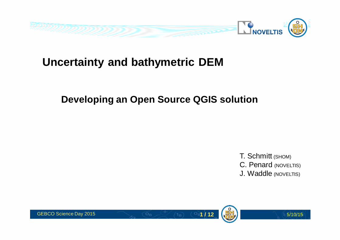
Methodology
In : A Biogeographic Assessment of Seabirds, Deep Sea Corals and Ocean Habitats of the New York Bight: Science to Support Offshore Spatial Planning, 2012
Data selection/processing
Characterization of individual dataset (metadata)
Interpolation
Estimation of the uncertainty (MC and/or BN)
Residue
Geostatisticalanalysis
Interpolated Bathymetric Surface
Krigging of the « micro-morphology » Krigging « error »
Combining components
Produced DEM and its uncertainty layer

5/10/15GEBCO Science Day 2015 5 / 12
Characterization of the source databased on IHO metadata standard
� Each sounding dataset in SHOM BDB is characterized by a set of metadata
� POSACC, SOUACC, TECSOU, QUALOT (IHO defined) are used to estimate the « error budget » of each individual dataset
� Missing one of them, Estimated by the date period (assuming precision is technology driven)
� Hypothesis of a radial distribution around the sounding
5/10/15GEBCO Science Day 2015 6 / 12
The math in one slide
Metadata + Uncertainty propagation model
Interpolation
Statistically determined uncertainty
Bathymetric datasets
Randomly modifiedbathymetric datasets
N times
Realization
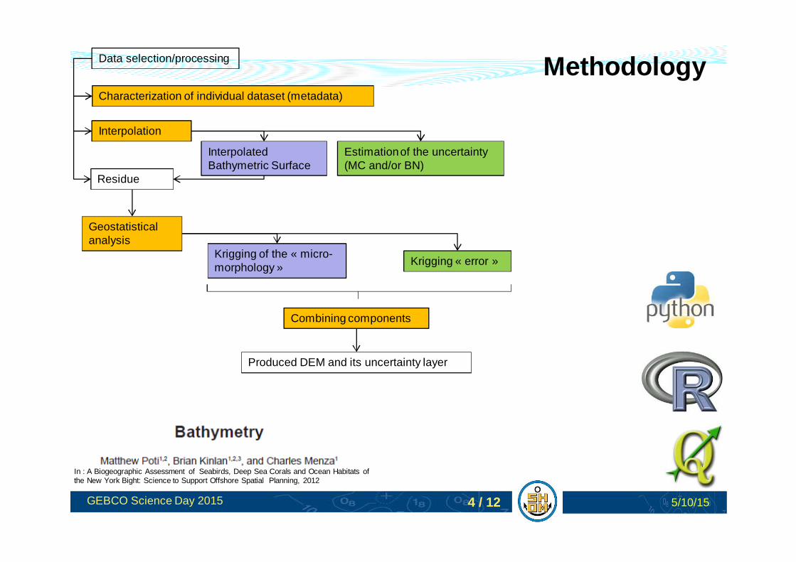
MONTE-CARLO
BAYESIAN NETWORK
GEOSTATISTICS
� Variogramme applied on the residue
EXPRESSING THE UNCERTAINTY
� 95 percentile – 5 percentile� Any other expression

5/10/15GEBCO Science Day 2015 7 / 12
Results 1/3

5/10/15GEBCO Science Day 2015 8 / 12
Results 2/3
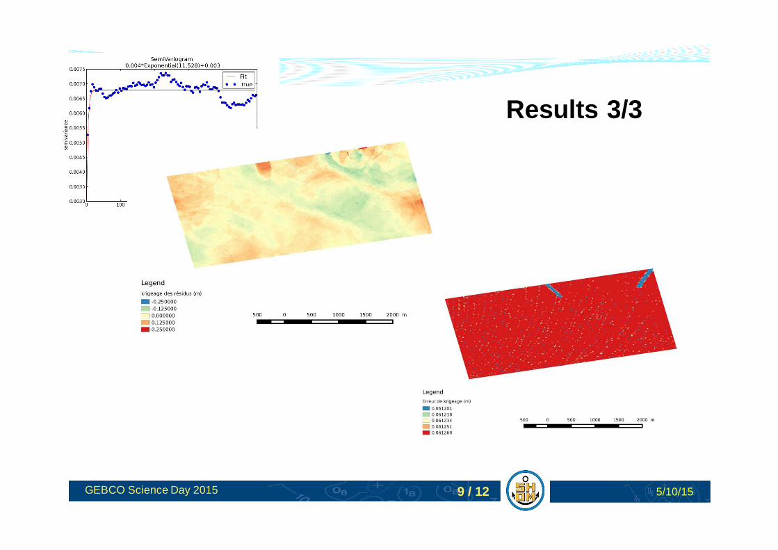
5/10/15GEBCO Science Day 2015 9 / 12
Results 3/3
5/10/15GEBCO Science Day 2015 10 / 12
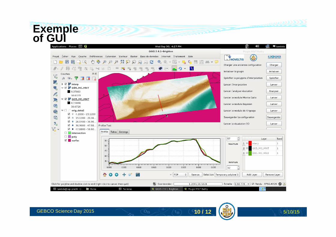
Exemple of GUI

5/10/15GEBCO Science Day 2015 11 / 12
Viewing / Exploiting uncertainty

5/10/15GEBCO Science Day 2015 12 / 12
CONCLUSIONS� An attempt to provide a tool to build bathymetric DEM with its corresponding
layer of uncertainty� Methodology built on “sound” mathematical background and adapted
hydrographic assumptions� Characterization of the source data relates to international standards (IHO)� Nearly independent of the interpolation technique� Open source solution / flexible coding
FUTURE WORK� Improve a-priori characterization of the source data (e.g. vertical precision as a
function of depth)� Improve Bayesian network learning and results� Improve performances (parallelization)� Propose better ways to present the results� BAG implementation