UMD 5 Report number: 327449 Rotterdam, September 20091)33567.pdf · 4.2 Data Collection ..... 33...
78
MASTER’S PROGRAMME I URBA MAAGEMET AD DEVELOPMET (October 2008 – September 2009) ASSESSMET O THE IMPLEMETATIO OF THE SPATIAL PLA AS A TOOL FOR DISASTER PREVETIO A CASE OF BADA ACEH, ACEH PROVICE, IDOESIA FITHRI FARAHAZ SAIFA Indonesia Supervisor: Dr. Ogenis M. Brilhante UMD 5 Report number: 327449 Rotterdam, September 2009
Transcript of UMD 5 Report number: 327449 Rotterdam, September 20091)33567.pdf · 4.2 Data Collection ..... 33...

MASTER’S PROGRAMME I URBA MA AGEME T A D
DEVELOPME T
(October 2008 – September 2009)
ASSESSME T O THE IMPLEME TATIO OF THE
SPATIAL PLA AS A TOOL FOR DISASTER PREVE TIO
A CASE OF BA DA ACEH, ACEH PROVI CE,
I DO ESIA
FITHRI FARAH AZ SAIFA
Indonesia
Supervisor:
Dr. Ogenis M. Brilhante
UMD 5 Report number: 327449
Rotterdam, September 2009
Assessment on The Implementation of The Spatial Plan As A Tool for Disaster Prevention: A Case of Banda Aceh, Aceh Province, Indonesia
ii
Summary
Less attention paid to the implementation of spatial plan by all stakeholders right from national to local levels as a regulatory instrument to guide the location of development has led to increasing number of disaster occurrences in Indonesia.
Same dilemma also happened in Banda Aceh. Due to ineffective development control regulations and a failure to comply with the master plan to deliver several reconstruction projects in Banda Aceh created challenges and problems that remained unresolved. Hence, to minimize the impact of future disaster, the local government of Banda Aceh replaced the previous spatial plan then revised it by incorporating mitigation measures in the present spatial plan (RTRW 2006 – 2026). Having a big interest in assessing the implementation of the present spatial plan, the researcher considers that there is a need to assess the effectiveness of the implementation of present spatial plan to minimize the impact of future natural disasters in Banda Aceh municipality.
This is an exploratory research method with survey as the main research strategy. The study employed in depth interview with 11 key respondents and semi closed questionnaire for 45 respondents in three selected villages in Meuraxa to obtain primary data.
The findings of the study indicated that there are nine mitigation measures proposed in Banda Aceh spatial plan such as escape route, escape building, open space, buffer zone, restriction development zone, and new development zone in order to minimize the impact of future disasters. Another finding revealed that several infrastructure plans have been implemented by the government to support disaster management activities, however not all activities had been successfully implemented like the provision of mangrove plantation as buffer zone due to lack of support from stakeholder and limited financial resources.
The study revealed that one of most important management problem occurred in the implementation of spatial plan is the decision to apply living law as a legal basis in issuing the building permit rather than establishing temporary legal basis while waiting for the approval of new spatial plan. As a result, this legal decision has created a numerous spatial plan’s misconducts on the ground has created numerous deviations of spatial plan in the ground and investment argument and community wishes often used by the government to justify the deviation of spatial plan.
The finding also shown that the policy to legalized all building properties that had been built before disaster has become one of the indications that the government is inconsistent to implementing its spatial plan policy to achieve safer city.
Finally, the absence of government’s socialization and community participation during the planning process of the spatial plan have resulted a serious awareness problem. The communities in the three selected villages of Meuraxa sub-district are simply not aware of the existence of spatial plan, which is also the reason of why they are not compliance with any of the permits and regulations. Therefore, from above mentioned findings we can conclude that the proposed research hypothesis “the implementation of present spatial plan can effectively
prevent the future impact of natural disasters in Banda Aceh” is partially accepted, meaning that the present spatial plan could not effectively prevent the future impact of natural disasters in Banda Aceh.
Key word: Spatial plan, Implementation, Disaster, Effective, Banda Aceh

Assessment on The Implementation of The Spatial Plan As A Tool for Disaster Prevention: A Case of Banda Aceh, Aceh Province, Indonesia
iii
Acknowledgements
Firstly and most importantly, I would like to thank the Allah the Almighty, for literally everything so that I finally can complete this research.
I would like to express my profound gratitude to my Supervisor, Dr. Ogenis M. Brilhante, for his invaluable support, encouragement, supervision and useful suggestions throughout this research work. As well as to my Mentor Maria Zwanenburg for her kind support and encouragement during my study.
I am as ever, especially indebted to my parents, Nurdin Ahmad and Fatimah for their prayers, love and supports throughout my life. Also, I wish to thank my sister, Rina Meutia and my brother, Muhammad Haekal for their continuous supports and care. Most importantly, . I would like to thank my Husband, Zulfahmi for his every moment love and support throughout this master’s tenure.
My sincere gratitude to all people who have supported my study completion, all my colleagues in urban management and development 5 (UMD 5), all staffs of the Netherlands Education Scholarship (NESO), All staffs of IHS (Sharon, Ruud, Cocky, Nigel, etc).
Thank you all.
Fithri Farahnaz Saifa
September, 2009
Rotterdam,
The Netherlands

Assessment on The Implementation of The Spatial Plan As A Tool for Disaster Prevention: A Case of Banda Aceh, Aceh Province, Indonesia
iv
Abbreviations
BAPPEDA Badan Perencana Pembangunan Daerah – The Regional Development Planning Body
BPN Badan Pertanahan Nasional – The National Land Agency
BAPEDALDA Badan Pengendalian Dampak Lingkungan Daerah -
BRR Badan Rehabilitasi and Rekonstruksi – The Rehabilitation and Reconstruction Agency
DIRJEN Direktur Jendral – Directorate General
GIS Geographic Information Systems
GoI Government of Indonesia
NGO Non-Governmental Organization
PAD Pendapatan Daerah – Regional Income
PERDA Peraturan Daerah – Regional Regulation
RTRW Rencana Tata Ruang Wilayah – Regional Spatial Planning
RALAS Reconstruction Aceh Land Administration System
SK Surat Keterangan – Letter of Reference
TDMRC Tsunami Disaster Mitigation Research Center

Assessment on The Implementation of The Spatial Plan As A Tool for Disaster Prevention: A Case of Banda Aceh, Aceh Province, Indonesia
v
Table of Contents
Summary .......................................................................................................... ii
Acknowledgements ......................................................................................... iii
Abbreviations .................................................................................................. iv
List of Boxes ................................................................................................... vii
List of Tables .................................................................................................. vii
List of Figures ............................................................................................... viii
List of Annex ................................................................................................... ix
Chapter 1: Introduction ................................................................................... 1
1.1 Background ............................................................................................................... 1
1.2 Statement of Problem ................................................................................................. 3
1.3 Study Justification ..................................................................................................... 3
1.4 Study Objective ......................................................................................................... 4
1.5 Research Questions .................................................................................................... 4
1.6 Hypothesis ................................................................................................................. 4
1.7 Conceptual Framework .............................................................................................. 4
1.8 Thesis Structure ......................................................................................................... 5
Chapter 2: Literature review ........................................................................... 7
2.1 Spatial planning ......................................................................................................... 7
2.1.1 International perspective of spatial planning ................................................... 7
2.1.2 Overview of Spatial Planning in Indonesia ..................................................... 8
2.1.3 Stakeholders in the Implementation of Spatial Plan ...................................... 12
2.2 Implementation Theory ............................................................................................ 12
2.3 Factors Influencing the Implementation of Spatial Plan ........................................... 13
2.4 Approaches to Effective Implementation of Spatial Plan .......................................... 15
2.5 Spatial Planning and Disaster Prevention ................................................................. 16
2.5.1 Historical Perspective ................................................................................... 16 2.5.2 Role of Spatial Planning in Disaster Management ........................................ 17 2.5.3 Land Use Policy and Measures Applicable to Disaster Prevention ................ 18 2.5.4 Land Management and Land Use Planning as a Disaster Risk Tool .............. 22 2.5.5 Good Practice Example: Flood Prevention by Land Consolidation ............... 24
2.6 Sustainability in Spatial Planning Perspective .......................................................... 25
2.7 Sustainable Development and Disasters ................................................................... 26
Chapter 3: Description of Research Area ...................................................... 29
3.1 General Overview of Banda Aceh City .................................................................... 29
3.2 Meuraxa Sub District ............................................................................................... 31
Chapter 4: Research Method ......................................................................... 33
4.1 Research Type and Strategy ..................................................................................... 33
4.2 Data Collection ......................................................................................................... 33

Assessment on The Implementation of The Spatial Plan As A Tool for Disaster Prevention: A Case of Banda Aceh, Aceh Province, Indonesia
vi
4.2.1 Literature study ............................................................................................ 33 4.2.2 Field work .................................................................................................... 33
4.3 Research Scope, Population and Sample Size .......................................................... 35
4.4 Data Analysis .......................................................................................................... 35
4.5 Data Quality ............................................................................................................ 35
4.5.2 Validity ........................................................................................................ 36 4.5.3 Reliability .................................................................................................... 36
4.6 Unit of Analysis, Variables and Indicators ............................................................... 36
4.6.2 Unit Analysis ............................................................................................... 36 4.6.3 Variables/Indicators...................................................................................... 36
4.7 Research Design ...................................................................................................... 37
4.8 Limitation and challenges during field work ............................................................ 38
Chapter 5: Result and Analysis ...................................................................... 39
5.1 Introduction ............................................................................................................. 39
5.2 Implementation of Present Spatial Plan .................................................................... 39
5.2.1 Identification of Mitigation Measures Proposed in Spatial Plan of Banda Aceh ............................................................................................................. 39
5.2.2 Categorization of Measures .......................................................................... 43
5.2.3 Measurable Output Achieved 2006 – 2009 ................................................... 44
5.2.4 Factor Influencing the Implementation of Spatial Plan .................................. 45
5.3 The effectiveness of the implementation of spatial plan ........................................... 48
5.3 How can the spatial plan implementation be improved ............................................. 49
5.4 Community Perceptions toward the content and implementation of spatial plan ................................................................................................................ 50
Chapter 6: Conclusions and Recommendations............................................ 55
6.1 Conclusions ............................................................................................................. 55
6.2 Recommendations ................................................................................................... 55
Reference ......................................................................................................... 57

Assessment on The Implementation of The Spatial Plan As A Tool for Disaster Prevention: A Case of Banda Aceh, Aceh Province, Indonesia
vii
List of Boxes
Box 2.1 Green Belt Policy and Spatial Planning ........................................................................... 21
List of Tables
Table 2.1 Overview of the European Planning System .................................................................. 7
Table 2.2 Implementation Variables and Their Relationship To Outcomes. ................................ 14
Table 2.3 Hazards Addressed by Spatial Planning ....................................................................... 17
Table 2.4 Fields of Action for Preventative Flood Management by Land Consolidation ............ 25
Table 2.5 The Operationalisation Of Sustainability In Spatial Planning ...................................... 25
Table 3.2 Population of Deah Glumpang before and after Tsunami ............................................ 32
Table 4.1 Source of Secondary Data ............................................................................................. 33
Table 4.2 List of Organizations of Key Respondents For In-Depth Interview ............................. 34
Table 4.3 List of Respondents for Semi Closed Questionnaire .................................................... 34
Table 4.4 Variables and Indicators ............................................................................................... 36
Table 5.1 Mitigation Measures Proposed in Banda Aceh Spatial Plan (N=10) ............................ 39
Table 5.2 Actual Infrastructure Plan ............................................................................................. 44
Table 5.3 Respondents Who Agree Whether the Spatial Plan Is an Ideal Plan for Banda Aceh .. 48
Table 5.4 Effective Criteria to Spatial Plan as a Tool for Disaster Prevention According To the Literature and What Were Implemented ...................................................................... 49
Table 5.5 Community Awareness on the Existence of Spatial Plan ............................................. 50
Table 5.6 Obtained Information According To Community ........................................................ 51
Table 5.7 Role of Mitigation Measures Proposed In Spatial Plan in Three Villages in Meuraxa 52
Table 5.8 Community Involvement in Planning Process .............................................................. 52
Table 5.9 Community Compliance with Permits and Regulation ................................................ 53
Table 5.10 Community Perception on Strategies Needed To Be Taken By the Government To Improved The Implementation of Spatial Plan ............................................................. 53
Assessment on The Implementation of The Spatial Plan As A Tool for Disaster Prevention: A Case of Banda Aceh, Aceh Province, Indonesia
viii
List of Figures
Figure 1.1 Record of Past Tsunamis ................................................................................................ 2
Figure 1.2 Conceptual Framework................................................................................................... 5
Figure 2.1 Spatial Planning Process ................................................................................................. 9
Figure 2.2 Structure of spatial plan ................................................................................................ 10
Figure 2.3 Summarizes Good Governance and Capacity Building ............................................... 16
Figure 2.4 The Position Land Management And Land Use Planning In Disaster Management Cycle ............................................................................................................................. 22
Figure 2.5 Sustainable Land Use Management As A Tool For Risk Reduction ........................... 24
Figure 2.6 Land Consolidation project ‘Hellinghauser Mersch’ at the river Lippe in Germany ... 25
Figure 3.1 Map of Indonesia .......................................................................................................... 29
Figure 4.1 Location of Selected Villages ....................................................................................... 35
Figure 4.2 Research Design ........................................................................................................... 38
Figure 5.1 Mitigation Measures Proposed in Banda Aceh Spatial Plan (N=10) ........................... 39
Figure 5.2 Location of Escape Building in Banda Aceh ................................................................ 41
Figure 5.4 Signage ......................................................................................................................... 43
Figure 5.3 Escape Building ............................................................................................................ 43
Figure 5.5 Mangrove coverage in Banda Aceh .............................................................................. 47
Figure 5.6 Comparison Number Seedling Planted And Extends Of Mangrove ............................ 48
Figure 5.7 Mitigation Measures Proposed in Three Villages in Meuraxa (N=45) ........................ 51
Figure 5.8 Community Perceptions on Benefits of Both Mitigation Measures in Term of Production Of Food And Livelihood Creation In Three Villages In Meuraxa ............. 52
Figure 5.9 Community Involvements in Planning Process Based on Occupation (N=45) ............ 53

Assessment on The Implementation of The Spatial Plan As A Tool for Disaster Prevention: A Case of Banda Aceh, Aceh Province, Indonesia
ix
List of Annex
Annex 1 List of Interview Questions .............................................................................................. 63
Annex 2 Survey Questionnaires ...................................................................................................... 65
Annex 3 Profile of Respondents of Survey with questionnaire ...................................................... 67
Annex 4 Land Use Plan .................................................................................................................. 69

Assessment on The Implementation of The Spatial Plan As A Tool for Disaster Prevention: A Case of Banda Aceh, Aceh Province, Indonesia
1
Chapter 1: Introduction
1.1 Background
Worldwide, natural disasters cause catastrophic losses. Average economic losses caused by disasters were $75 billion in the 1960s, $138 billion in the 1970s, $213 billion in the 1980s, and more than $659 billion in the 1990s (Munich Re, 2002). While most losses are in developed countries, these estimates fail to capture the impact of disasters in poor countries that often bear the impact of human losses and livelihoods. Compared to developing countries, the absorptive capacities of developed countries are greater, the impact ratios on economies are smaller, and the recovery rates are more rapid. More, 85 percent of people exposed to natural disasters located in countries of medium or low economic development (Munich Re, 2002).
Disaster risks pose a major threat to the development process (ISDR, 2004). In some countries, development means greater ability to afford the investment needed to build or disaster resilient communities. In other countries, growth is accompanied by hazard development decisions that place more people and property in risk. In the arouse of these patterns, rebuilding from disasters has been devastating to poor countries, as losses consume enormous amount of limited available capital, significantly reducing resources for new investment. The adverse effects on employment, balance of trade, and foreign indebtedness can be felt for years (Committee on Disaster Research in the Social Sciences, 2006)
Indonesia, due to its topographic features, is highly prone to various natural disasters, namely earthquake, tsunami, volcano eruption, flood, landslide, drought, forest fire and so forth. During the past ten years, from 1999 to 2008 alone, natural disasters are said to have left approximately 180,000 people dead and approximately 8.4 million more to suffer, causing the financial damages that reached as much as 10 billion US dollars in Indonesia.
Primarily, Indonesia was hit by an average of 400 earthquakes a year, which measured more than 4 on the Richter scale. Indonesia also has 129 active volcanoes (Kriswati, 2008) and 17 of them including Mt. Merapi are currently very active. Furthermore, tsunamis accompanying earthquakes and volcano eruptions also occur frequently. Approximately 100 tsunamis occurred in Indonesia in the last 400 years from the year of 1600, which are said to have killed more than 340,000 people in total. See Figure.1 Record of Past Tsunamis.
Some parts of Indonesia belong to the area prone to be hit by the Asian monsoons. Excessively heavy rain in those areas results in numerous occasions of flood and ensuing disasters each year. For instance, the massive flooding in Jakarta in 2007 left 80 people dead or missing, causing the financial damages that reached 5.18 trillion rupiah (ODA Indonesia Website, 2009). Furthermore, landslides caused by rainfall during the rainy season and earthquakes occur throughout the country due to the volcanoes and weak geographical structures scattered in wide areas.
Further, poorly planned development can turn a recurring natural phenomenon into a human and economic disaster. Allowing dense populations on a floodplain or permitting poor or unenforced building codes in earthquake zones is as likely as a natural event to cause casualties and losses. Similarly, allowing the degradation of natural resources increases the risk of a disaster (Jock, 2003)

Assessment on The Implementation of The Spatial Plan As A Tool for Disaster Prevention: A Case of Banda Aceh, Aceh Province, Indonesia
2
Figure 1.1 Record of Past Tsunamis
Source: ODA Indonesia website, 2009
According to Kotter (2003) despite, disaster are caused by natural, human, or a combination of both the frequency of disasters is rising at an alarming rate, not necessarily because natural hazards have become more frequent, but because more and more people have chosen to live and work in locations that put them in risk (Schmidt-Schmidt-Thome et. al, 2006). Many have chosen to live in areas at risk from repeated flooding and seismic activity, often settlements affected by these disasters have rarely been relocated, but tend to be rebuilt in close vicinity or on top of earlier disasters with little or no attention to the need land use policy or for sound building practices. Traditional aspects are reason for staying, for instance people being deeply rooted in an area or many traditional settlements have certain advantages to natural.
Generally, In Indonesia coastal regions and small islands are locations that highly exposed to coastal abrasion, tsunami, tide wave, faces increasing sea water (sea-level rise), flooding, sedimentation and pollution, and so forth. This is the situation and condition that is quite vulnerable due to the complexity of the rapid growth of coastal areas that often ignore aspects of natural disaster mitigation in development processes. Lack of planning based on mitigation measurement is one of the factors that contribute to the increased of disaster vulnerability.
Since natural hazards cannot be avoided (Marttila et al, 2005) more efforts should be put in to reduce some of their consequences. Spatial planning plays an important role in mitigation, which aims reducing damage to people, property, and resources by taking measures before a disaster occurs (Schmidt-Thome, 2006a). The importance of spatial planning in risk management has been understood and implemented more vigorously since the mid 1990’s (Burby 1998, Godschalk et al. 1999). Nowadays, the integration of disaster prevention element into spatial planning practices is constantly receiving higher attention. Many countries have been using this concept as one of the instruments. Spatial planning is a non structural measurement that partly can establish economic and social goals for given locations in the light of various risks associated with the events that can cause disaster and partly bring risk factors to bear on the planning process (United Nations, 1978).

Assessment on The Implementation of The Spatial Plan As A Tool for Disaster Prevention: A Case of Banda Aceh, Aceh Province, Indonesia
3
1.2 Statement of Problem
Less attention paid to the implementation of spatial plan by all stakeholders right from national to local levels as a regulatory instrument to guide the location of development has led to increasing number of disaster occurrences in Indonesia (Hukumonline 2007, TEMPO 2008)
Same dilemma also happened in Banda Aceh before and after Tsunami 2004 where Ministry of National Development Planning (BAPPENAS) in cooperation with various related parties prepared a holistic and comprehensive planning, in the form of a Master Plan in order to accelerate the rehabilitation and reconstruction of post disaster. The master plan or “blueprint” was issued on 2nd March 2005 as guidance for the government and donors for the development and reconstruction of houses, infrastructure and other facilities. In the master plan stated that in which no rebuilding would be allowed within a 2 km buffer zone along the province’s coast, and virtually all villages, towns and fishing communities in that zone should be relocated. In Banda Aceh, the blueprint divided the ruined areas of the city into three zones: totally destroyed, structurally damaged and not-damaged-but-flooded. The plan called for the construction of a sea wall to protect the city and the relocation of all the surviving households and businesses in all three zones to three new futuristic “model cities” that the government would construct ten to thirty kilometers inland. All three zones would then become coastal greenbelts, where no building would be allowed (ACHR, 2005).
However, contradicted to the plan, many houses, buildings, fishponds, economic infrastructure and facilities were built in highly disaster-prone areas - directly to the sea- not behind the set-back zone, green belt or other buffer zone provisions (Dahuri, 2007). In addition, most of the houses were sometimes built in environmentally sensitive areas, or in areas where the water table is very close to the surface. The surface waters in many areas near human settlements were mixed with seawater and other surface materials. Often, inadequate or the absent of sanitation facilities were a major source of ground and surface water pollution, particularly in areas with very shallow water tables (UNEP, 2006).
Further, most of fisherman or other coastal communities whose livelihoods depend on the sea, for practical reasons, wanted to move back-a defiance of the government relocation policy- and rebuilt their houses in the same proximity to the sea or rivers as they were before.
Due to ineffective development control regulations and a failure to comply with the master plan to deliver several reconstruction projects in Banda Aceh created challenges and problems that remained unresolved. Hence, in order to minimize the impact of future disaster, the local government of Banda Aceh replaced the previous spatial plan (RTRW 2002 -2010) then revised it by incorporating mitigation measures in the present spatial plan (RTRW 2006 – 2026). Having a big interest in assessing the implementation of the present spatial plan, the researcher considers that there is a need to assess the effectiveness of the implementation of present spatial plan in the overall management of disaster risk within Banda Aceh municipality.
1.3 Study Justification
The study is carried out because of following reasons:
a. The research on spatial planning as an instrument of disaster risk reduction management towards sustainable development in post disaster area is necessary to carry out. It will perceivably facilitate the local government and planner to identify necessary knowledge and information by understanding its main causes and impacts of the problem, on how to deal with major issues on disaster risk management.

Assessment on The Implementation of The Spatial Plan As A Tool for Disaster Prevention: A Case of Banda Aceh, Aceh Province, Indonesia
4
b. The results of this study are expected to suggest for effective spatial planning in the disaster risk reduction management in Banda Aceh and other local government.
c. This study is part of the requirement to obtain master’s double degrees in urban management and development of Institute of Housing and Urban Development Studies (IHS)-Erasmus University.
1.4 Study Objective
The aim of this study is to assess the effectiveness of the implementation of present spatial plan to minimize the impact of future natural disasters in Banda Aceh municipality.
1.5 Research Questions
1. How is the implementation of present spatial plan in Banda Aceh? a. Which mitigation measures are proposed in the present spatial plan of Banda Aceh? b. What outputs have been achieved so far in the period 2006 – 2009? c. Which factors influence the implementation of present spatial plan?
2. How effective is the implementation of present spatial plan in minimizing the impact of future natural disasters at the city scale?
3. How can the local government improve the implementation of present spatial plan of Banda Aceh?
4. What is public perception toward the content and the implementation of present spatial plan in regard to mitigation measures in Ulee Lhee, Deah Baro and Deah Glumpang?
1.6 Hypothesis
The implementation of present spatial plan can effectively prevent the future impact of natural disasters in Banda Aceh.
1.7 Conceptual Framework
The conceptual framework in this research is formulated from literature review, started from understanding the position of spatial planning as the theme of this study in the risk management particularly in prevention and mitigation management. Connected to wider concept of sustainability, spatial planning has a play important role in mitigation, which aims at reducing damage to people, property, and resources in over all disaster prevention and mitigation. Figure 1.2 below will give description on the flow of literature review used in the thesis in the form of conceptual framework.

Assessment on The Implementation of The Spatial Plan As A Tool for Disaster Prevention: A Case of Banda Aceh, Aceh Province, Indonesia
5
Figure 1.2 Conceptual Frameworks
1.8 Thesis Structure
This study report consists of content which is presented in six chapters as indicated below;
Chapter one consists of the introduction and background of the study, problem statement and justification of the study. Also presented under this chapter is; the research objectives, research questions and hypothesis.
Literature review is presented in chapter two. Literature which enables the researcher to identify what has been studied or researched in the area of spatial planning and what the findings were presented.
Chapter three consists of the description of research area. This includes the population, information about the natural setting of the research area, local economic development, infrastructures, hazards and environmental management of Banda Aceh city among other key issues.
SUSTAINABLE DEVELOPMENT
• ECONOMIC DEVELOPMENT
• SOCIAL DEVELOPMENT
• ENVIRONMENTAL
PROTECTION
SPATIAL PLANNING
PROCESS
SPATIAL PLAN MAKING
IMPLEMENTATION OF
SPATIAL PLAN
MITIGATION MEASURES
SUB - DIVISION
ZONING
LAND USE REGULATION
BUILDING CODE
COORDINATION FINANCIAL
INSTITUTIONAL CAPACITY PARTICIPATION
ENFORCEMENT INTEGRATION
SPATIAL
PLAN

Assessment on The Implementation of The Spatial Plan As A Tool for Disaster Prevention: A Case of Banda Aceh, Aceh Province, Indonesia
6
Chapter four in this study report is presenting research. This includes information of interviews, questionnaires and secondary data sources which were used by the researcher to collect data/
Chapter five consists of the discussion of research findings of the study. Presented in sequence to the research questions for the categories of respondents
Chapter six representing conclusions drawn by the researcher based on the findings discussed in chapter four and finally recommendations on how to improve the implementation of spatial plan as a tool for disaster management as well as suggestions for further research.
Assessment on The Implementation of The Spatial Plan As A Tool for Disaster Prevention: A Case of Banda Aceh, Aceh Province, Indonesia
7
Chapter 2: Literature review
2.1 Spatial planning
2.1.1 International perspective of spatial planning
There has been much debate about the meaning of spatial planning, a term which does not easily translate between European languages (Williams, 1996b; Faludi and Waterhout, 2002). Some use the English term “land use planning” (e.g., Ireland), “land planning” (Italy), or “spatial planning” (Germany: Ramplanung); others use “spatial development” (Poland) or “regional development planning” (France).
According Healay (2004) spatial planning refers to self conscious collective efforts to re-imagine a city, urban region or wide territory and to translate the result into investment and principles of land use regulation. Spatial planning can also be understood and defined in a variety of different ways (Tewdwr-Jones, 2004). It is an activity that may take different form and different context depending on institutional and legal context or variation in planning cultures and traditions (Healey, 1997). Having a great deal concerned with “land” in a broad sense, sometimes some authors called it as physical planning (Larsson, 2006). Another definition in French urbanism dictionary, spatial planning is action and practice (rather than science, technique, or art) of arranging with order, across space of a country and in a prospective vision, people and their activities, infrastructure and communication tools that they can use, strategically taking into account natural, human, and economic constraints.
So the use as well as the understanding of the term is wide open. Clear definitions, however, are important to avoid mistakes (Faludi, 2008). Table 2.1 offers an overview of the several forms of planning.
Table 2.1 Overview of the European Planning System
Spatial Level Spatially Relevant Planning Spatially No relevant
Planning
Comprehensive Sectoral (transport, water, geology, emergency response, etc)
Forms of non spatial management on different spatial levels
Europe
SPATIA
L PLANNIN
G
European spatial
development (no binding character)
SECTORAL AUTHORITIES
Environmental policies,
TEN, CAP
e.g., budget planning
Member state Spatial development planning
E.g., national transport network plan
E.g., defense planning, education
Sub member state level (federal state,
region, or other spatial unit)
Provincial planning (partly
land use related)
E.g., river basin authorities in charge of management
plans, partly land use planning and management related
E.g., cultural development,
education planning
Assessment on The Implementation of The Spatial Plan As A Tool for Disaster Prevention: A Case of Banda Aceh, Aceh Province, Indonesia
8
Municipality (all planning on this level can be
subsumed together under the term “Urban Planning and Management”)
Local land use planning
E.g., waste, sewage planning, public transport planning; municipalities are
in charge of (land use management)
e.g., primary education, municipal budget planning
Source: Faludi, 2008
Further, spatial planning is a particular form of public policy. It focused on spatial dimension of a wide range of other sectoral policies, from economic development, transportation and environmental protection through health, culture and language (Adam et al, 2006).
According to Koresawa and Konvitz (2001), the scope of spatial planning differs greatly from one to another. Nevertheless, in nearly all countries spatial planning systems encompass into two dimensions- administrative and functional.
Functionally, there are three fundamental functions in spatial planning:-
• Provides a long and medium term strategy in pursuit common objectives, incorporating different perspective of sectoral policies
• Deals with land use physical development as distinct sector of government activity alongside transport, agriculture etc.
• Can also mean the planning of sectoral policies according to different spatial scales
Administratively, spatial planning is practiced at various levels of government, namely national, regional and local levels. National spatial planning guides spatial development on the national scale as well as exercise spatial planning at lower levels of government. National spatial planning also serves a policy tool to address the distribution of economic activity and social welfare between regions, which may be termed as national-regional planning. At the regional level planning attempts to shape development. Lastly, at local or municipal level, spatial planning in most cases focuses on land use planning to regulate and property uses.
2.1.2 Overview of Spatial Planning in Indonesia
An important point to consider is the definition of spatial planning in Indonesia, which is constantly being confused by many stakeholders, which contributes to the exaggeration of the problem. In common term, definition of spatial planning in Indonesia tends to be associated with land allocation planning only (Murdiono, 1993). This resulted in a separated handling with sector plan, such as the national agriculture planning, forestry planning, transmigration planning and resettlement planning, infrastructure planning. Later, the Government of Indonesia recognized that the inclusion of sector in definition is necessary because the products are similar to statutory spatial plans, only differently called and regulated.
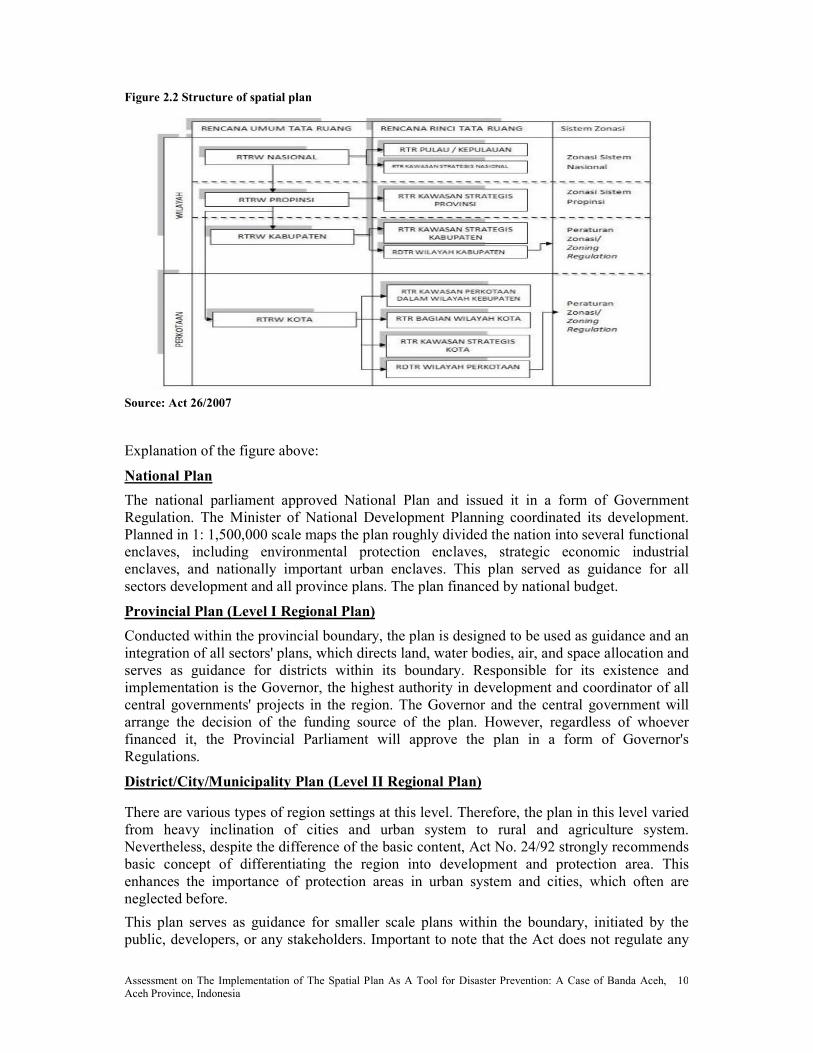
As stated in Act 26/2007, spatial planning is defined as a mechanism consists of planning process, implementation and development control. The spatial planning process could be seen in figure 2.1

Assessment on The Implementation of The Spatial Plan As A Tool for Disaster Prevention: A Case of Banda Aceh, Aceh Province, Indonesia
9
Figure 2.1 Spatial Planning Process
Source: Spatial Planning Board, 2005
a. The Process of formulating the spatial plan
This is the stage where a spatial plan is developed which includes spatial plan making and the process of determination of a layout. The spatial plan comprises:
• A structure plan, a plan that illustrate the proposed structure and layout of future development area. The preparation of a structure plan is one of the first steps in progressing proposals for the development of new urban areas. In addition to illustrating details such as transportation, electricity, telecommunication, water resources and location of retail and community facilities such as shops, schools and public open space. A structure plan also shows details such as housing density, land use classification and buffer zone as a function of socio-economic for the community
• Space utilization pattern plan includes the direction for distribution space allocation for various activities both space allotment for function and environment protected conservation area.
Hierarchically, as a regulatory instrument spatial plan consists of National spatial plan (RTRW Nasional), the provincial spatial plan (RTRW Propinsi) and district spatial plan (RTRW Kabupaten/Kotamadya). All level of government is required to make the plan and implement it in a way to avoid overlapping and use it as guidance for all sector development in each respective region. The structure of spatial plan can be seen in figure 2.2
Assessment on The Implementation of The Spatial Plan As A Tool for Disaster Prevention: A Case of Banda Aceh, Aceh Province, Indonesia
10
Figure 2.2 Structure of spatial plan
Source: Act 26/2007
Explanation of the figure above:
ational Plan
The national parliament approved National Plan and issued it in a form of Government Regulation. The Minister of National Development Planning coordinated its development. Planned in 1: 1,500,000 scale maps the plan roughly divided the nation into several functional enclaves, including environmental protection enclaves, strategic economic industrial enclaves, and nationally important urban enclaves. This plan served as guidance for all sectors development and all province plans. The plan financed by national budget.
Provincial Plan (Level I Regional Plan)
Conducted within the provincial boundary, the plan is designed to be used as guidance and an integration of all sectors' plans, which directs land, water bodies, air, and space allocation and serves as guidance for districts within its boundary. Responsible for its existence and implementation is the Governor, the highest authority in development and coordinator of all central governments' projects in the region. The Governor and the central government will arrange the decision of the funding source of the plan. However, regardless of whoever financed it, the Provincial Parliament will approve the plan in a form of Governor's Regulations.
District/City/Municipality Plan (Level II Regional Plan)
There are various types of region settings at this level. Therefore, the plan in this level varied from heavy inclination of cities and urban system to rural and agriculture system. Nevertheless, despite the difference of the basic content, Act No. 24/92 strongly recommends basic concept of differentiating the region into development and protection area. This enhances the importance of protection areas in urban system and cities, which often are neglected before.
This plan serves as guidance for smaller scale plans within the boundary, initiated by the public, developers, or any stakeholders. Important to note that the Act does not regulate any

Assessment on The Implementation of The Spatial Plan As A Tool for Disaster Prevention: A Case of Banda Aceh, Aceh Province, Indonesia
11
plans below this level to ensure flexibility and enhance public initiative and participation. Responsible for the co-ordination of the plan are District Chief in district and municipality areas, and Mayor in cities. The plan can be financed by District budget, Provincial budget, National budget, or any combination among the three, depends on the result during budgeting planning. However, its approval is being conducted at the District/Level II parliament.
Taking cognizance of new participatory approaches, the process of spatial plan making must be carried with participatory approach through active involvement of all stakeholders. In this process, the role of the community cannot be ignored, because the community is the main subject and object in the spatial. Community involvement in spatial planning has been explicitly stipulated in Act 24/1992 and Government regulation 69/1996 about the implementation and responsibilities and the forms of governance and the role of society in spatial planning.
Further, underlined that the need for development in a region cannot be restricted from other regions, therefore spatial planning cannot be performed only with the attention to the interest of internal (inward) but should also consider the influence of other regions and the impact on the other areas.
b. Implementation Process Plan
The implementation process should be carried out through:
a. Implementing strategic programs indications (complemented by budget indications) carried out by regional related institution/agency gradually within the planned time frame referring to RTRW Nasional and its operational instruments according to priority scale and budget constraints.
b. Providing incentives and disincentives in order to encourage stakeholders to realize the objectives of spatial development plan.
a) Incentives in economic sector can be realized through awarding compensations, payments, and certain mechanism of land rent, etc. While incentives in physical sector can be realized through developing facilities and infrastructures required to serve the area development.
b) Disincentives are main instruments to prevent or reduce spatial utilization deviations realized through high taxes or unavailability of facilities and infrastructures.
This is a stage to actualize the structure plan and space utilization patterns according to the layout plan through the preparation and implementation of the program and financing it.
Programs are developed based on space utilization plan layout that has been defined by the respective stakeholders in accordance to the authority.
In the preparation and the implementation of the program each stakeholder should synchronize and coordinate to create synergies in achieving goal. In the implementation process, stakeholders both public and private as well as community are required to coordinate and synchronize in term of scope and type of the program, determination the location of development and distribution of roles and responsibilities and financing.
c. Controlling of the Utilization of Space
After the implementation of the plan, the next step is to control the spatial utilization and development through monitoring, reporting, evaluation, readjustment, and endorsing development permit mechanism and imposed sanctions carried out by local government agency based on Local Spatial Development Plan indications of protected areas, cultivated areas, build-up areas, and defined areas. (Dardak, 2005)

Assessment on The Implementation of The Spatial Plan As A Tool for Disaster Prevention: A Case of Banda Aceh, Aceh Province, Indonesia
12
In this phase, the government is able to measure in how far the implementation of the spatial has been achieved by simply analyzing the existing land use structure areas compare to the approval spatial plan.
The analytical phase can be done by calculating the percentage of misuse or deviation over the planned areas (Idjaz, 2009)
%%100 bxX
A=
A = Existing area
X = Planned areas
b = misuse or deviation area
2.1.3 Stakeholders in the Implementation of Spatial Plan
The implementation of spatial plan could be done by the Central Government, Local Government, private sector or the civil society, either separately or together while utilization of space by the community can be done either a person, group of people including indigenous community, professional groups, and corporations.
These stakeholders could be grouped into several categories:
1. Stakeholders that involved in policy – decision making process consists of: a. Executive like Bappenas, Public Work, National Land Agency, Bappeda, Local
Secretary and Head of Regional and sectoral institutions such as Central and Local Government Department / Office that have related functions Forestry, Agriculture and Agriculture, Trade and Industry, Mining, Marine, Transportation, Environment / Bappedal, Tourism;
b. Legislative, such as DPR and DPRD I and DPRD II; c. Judiciary
2. Stakeholders impacted from a policy, consisting of: a. Local Residents Group b. Residents in accordance with the group activities, such as groups of fisherman,
farmer, Labor, Water Users, Forum Religion and so on. 3. Stakeholders monitored the policy, consists of:
a. Parliament, b. DPRD I and DPRD II; c. NGOs; d. Press / media; e. community Forum; f. political party; g. Association of Professional and h. Universities.
4. Stakeholder from Interest Group consists of:
a. political party; b. NGOs; c. Entrepreneur; d. community forum e. Professional
Associations; f. Universities and g. Mediation Group.
2.2 Implementation Theory
Researchers have investigated public policy implementation since 1970s in an effort to determine keys to implementation success. This body of theory applies to all forms of public policy and can thus help in designing effective implementation strategies for strategic land use planning.
The broader social ideals of law and democracy form the basis of the traditional “top-down” model of policy implementation (Hill and Hupe, 2002). In this model, policy implementation is purely administrative duty where control is exerted over the implementation process to ensure success (Mazmanian and Sabatier, 1989). Democratic accountability is maintained
Assessment on The Implementation of The Spatial Plan As A Tool for Disaster Prevention: A Case of Banda Aceh, Aceh Province, Indonesia
13
because elected officials make policy. As such, policy makers control implementation by designing and structuring the process, determining who is involved, ensuring that sufficient money and other resources are provided, and assuring that implementation is properly overseen.
In reality, many of factors affecting implementation success are beyond the control of policy makers. Often, the very things which top down theorists..Surge must be controlled are the elements which are difficult to bring under control (Hill, 1997, 139). Policy makers, for example, generally have little control over socioeconomic conditions, technological capacity, or the degree of support for a policy within or outside government. In turn implementation may be undermined by organizational complexities and the political dynamics between actors in implementation (Rein and Rabinovitz, 1978; Bardach, 1977; Hood, 1976).
The alternative “bottom-up” model views implementation as part of policy design process. In this approach, policy is conceived as an output of the implementation process rather than an input from the top (Hill, 1997); the process of implementation is conceived as circular and iterative rather than linear and singular.
The core concept of the bottom up model is its recognition of policy transformation by all parties involved in implementation. In land and resources management, implementation involves a number of government agencies and personnel, private industry, nongovernmental organizations, special interest groups, and the general public. Political mediation among these actors inevitably modifies policy, potentially resulting in significant changes (Barrett and Fudge, 1981; Rein and Rabinovitz, 1978; McLaughlin, 1975). Consequently, actors within a policy process are policy designers. As critics point out, democracy may be subverted in the process (Hill, 1997; Nakamura and Smallwood, 1980)
Policy modification through implementation can be beneficial, however. Interactions among actors in policy making can allow for creative problem solving (Magerum, 1999a; Berman, 1980), especially in situations where are a limited understanding of a problem (Rothstein, 1998); Rein and Rabinovitz, 1978). Thus, strict adherence to the top down model may be not in the best interest of those wishing to solve complex problems.
Margerum (1999) argued that implementation structures should adopt appropriate balances of coordination and cooperation among actors, and appropriate blends of administrative and operational activities among actor agendas. Clearly, each implementation environment is different and consideration must be given to designing implementation processes accordingly.
2.3 Factors Influencing the Implementation of Spatial Plan
Implementation is the empirical black hole of the planning field. Though planners create a wide range of planning products, from comprehensive plans to zoning ordinances, as a field we have little or no idea what becomes of them. Spatially restrictive policies are one example where we do not assess outcomes. When a comprehensive plan restricts development on sensitive soils, does that happen? Do floodplain ordinances actually stop development in floodplains? In short, what happens to local spatial policies after they are adopted—and why? Few studies of this nature have been conducted. Many writers have complained about the fact that planners or scholars do not conduct post hoc evaluations of planning products (Talen, 1997; Reade, 1983). As a field, we often study planning rather than doing—in other words, the process of preparing plans and policies rather than the process of implementing them. As Talen notes, “Success in planning is focused on successful procedures…although there is no tie to the empirical realities of the implementation of procedures and plans” (1997, p. 581).

Assessment on The Implementation of The Spatial Plan As A Tool for Disaster Prevention: A Case of Banda Aceh, Aceh Province, Indonesia
14
He further point out that there are several implementation factors identified in literature that could be seen in table 2.2
Table 1.2 Implementation Variables and Their Relationship To Outcomes.
Implementation factor identified
in literature
Played role in
implementation
Played little or no role in
implementation
Degree of political support x
Stakeholder inclusion X
Degree of change required x
Adequacy of staff/funds X
Number of veto points X
Media involvement X
Adequate causal theory X
Decision rules of implementing agencies
x
Involvement of street-level implementers
X
Presence of entrepreneur X
Organizational structure x
Policy complexity X
More, according to Talei and Mansourian (2008) there are different factors that influence implementation of spatial plan:
• Insufficient skilled personnel within municipalities and private consultant companies,
• Inadequate attention to all factors existed in reality,
• Inadequate attention to intelligence stage of planning process and preparing the plans with insufficient insight and information,
• Ambiguity concerning the future trend of city development,
• Insufficient use of new technologies and tools such as GIS, SDSS/SPSS,
• Using traditional planning methods resulting preparing static plans without any revision during next 5 to 10 years,
• Lack or unavailability of required data for decision making,
• Non-involvement of other urban management organizations (i.e. utilities companies) for preparing the spatial plans,
• Less attention to public participation planning approach in preparing the plans,
• Unsuitable organizational structure for implementing the urban plans
Successful plan implementation depends on the quality of a plan. Mazmanian and Sabatier (1989, 26) argued that good plans are built upon “sound causal theories” such that “he principal causal linkages between intervention and attainment of program objectives are understood.” Albert, Gunton, and Day (2004; 2002) reported that plans must be built upon an accurate conception of why a problem exists, and must adequately explain how interventions can address and solve a problem. Given adequate understanding, implementation is more
Assessment on The Implementation of The Spatial Plan As A Tool for Disaster Prevention: A Case of Banda Aceh, Aceh Province, Indonesia
15
likely to successful because stakeholders understand what a plan proposed to do and they are more likely to support its implementation (Vedung, 1997; Goggin et al., 1990; Mazmanian and Sabatier, 1989; Hogwood and Gunn, 1984). Further, Albert, Gunton and Day 2004; 2002; Jackson and Curry, 2002; Margerum, 2002, Goggin et al., 1990; Mazmanian and Sabatier, 1989) revealed that plan objectives and its strategies must be stated clearly and consistently for those who will be interpreting them.
Another obstacle found of ineffective implementation of spatial plan is lack of coordination, cooperation and mutual collaboration among stakeholders. Sectoral ego and unwillingness to understand other sector’s interests becoming one of the obstacles to achieve synergies among government institutions. It is reflected from the existence of conflict of interest between sector and region in utilizing the space as well as lack of integration in the areas of infrastructure development (Dardak, 2006).
In addition to problems of coordination, problems related to consistency in enacting the spatial plan as the basis of development are also very often found. In some cases, the spatial plan is sacrificed on the altar of political expediency when there is a desire to perform the actual construction which does not comply with the existed spatial plan. Investment argument is often considered as a basis to modify the plan layout. Consequently, spatial plan is no longer guidance for directing the location of investment but only as a tool that could be adjusted as a justification of investment activities (Indonesia Spatial Planning Board 2005, Dardak, 2006).
Further, lack of awareness by government, clear institution structure and implementation strategy has made the implementation ineffective (Zhang, 2005)
From the description above, the researcher agreed that less attention has been paid to spatial plan implementation in local government in Indonesia has led to many environmental problems continued to exist in urban areas. Inadequate financial resources in local government has made the government violated their own spatial plan like endorsing building permit for expropriation of protected cultivation land into commercial area. More, the author acknowledged that the inability of the public sector authorities to enforce regulations governing land development is also becoming one of the biggest challenges in implementing the spatial plan in attaining sustainable development in Indonesia.
2.4 Approaches to Effective Implementation of Spatial Plan
An effective implementation is indeed influenced by the attitudes of government; attitudes to spatial planning itself by community, it’s also affected by the competence and credibility of the organization developing and trying to implement the plan (MOLG, 2003c).
Good governance and capacity building are the two areas that could be central approaches to deal with institutional and organization challenges that often happened in the process and implementation of spatial planning.
Governance as defined by United Nations is a process of decision-making and the process by which decisions are implemented (or not implemented). It brings together the actions of several actors at all levels, including government, ministries, international organizations, NGOs, research institutes, universities and finance institutions.
Besides the aspect of participation, the other characteristics of good governance — rule of law, transparency, responsiveness, consensus orientation, equity, effectiveness, efficiency, accountability and strategic vision — are a precondition for effective spatial planning practice as tool for disaster risk reduction in order to achieve sustainable development (Magel &

Assessment on The Implementation of The Spatial Plan As A Tool for Disaster Prevention: A Case of Banda Aceh, Aceh Province, Indonesia
16
Wehrmann, 2001). In addition, good governance can be seen as an effective instrument for poverty alleviation and to achieve the UN Millennium Development Goals.
Figure 2.3 Summarizes Good Governance and Capacity Building
Source: FIG, 2006
The ISDR Secretariat of the United Nations defines capacity building as the efforts aimed to develop human skills or societal infrastructures within a community or organization needed to reduce the level of risk (ISDR, 2004).
In the context of spatial planning, capacity building can be achieved through training and education for example planners are advised to take advantage of the role of Geographical Information Systems in supporting all aspects of disaster managements. Disaster planning, response, mitigation, and recovery all become more efficient through the use of GIS (Suresh et al., 2005). Transfer of technical expertise, dissemination of traditional knowledge, strengthening infrastructures and enhancing organizational abilities are other forms of strategies that could be carried out to improve the institutional efficiency (ISDR, 2004)
Despite having the same point of view with the author, the research believes that integration of disaster mitigation measures into the spatial plan is the key to effective implementation in minimizing the potential risk of disasters.
2.5 Spatial Planning and Disaster Prevention
2.5.1 Historical Perspective
The integration of hazard and related topics into planning started with disaster relief regulations approximately 30 years ago (Anderson et al. 2003). Since the 1980's natural hazard mitigation started to be integrated in spatial planning in developed countries, which then led to a worldwide approach, for example the UN proclamation of the International Decade for Disaster Reduction in 1990 (Quarantelli, 1995). Despite this international initiative, the consideration of hazards and risk mitigation in planning policies remains rare (UNDP, 2004). The importance of spatial planning in risk management has been understood and implemented more vigorously since the mid 1990's (Burby 1998, Godschalk et al. 1999). One of the first national acts on planning, hazard and risk was signed in the United States of America in 2000 (Disaster Mitigation Act, 2000).

Assessment on The Implementation of The Spatial Plan As A Tool for Disaster Prevention: A Case of Banda Aceh, Aceh Province, Indonesia
17
In the 1990's, natural hazard and risk considerations began finding their way into planning in Europe (Fleischhauer et al. 2006), but many countries still lack clear guidelines on how to deal with hazards and risk on a spatial planning level (UNDP 2004).
There are several, mainly economic, reasons for this recent stronger focus on natural hazards and planning. From a global perspective, the insured losses due to natural hazards have been rising in the past decades, with a large increase in losses in the last years (Munich Reinsurance Company 2004). An analysis of natural hazard related financial loss data reveals that there has been an increase in both catastrophic events and insured losses since the 1960´s. However, looking back over the last two decades it can be seen that the dramatic increase of financial losses is not reflected to the same extent by the increase of (reported) catastrophic events or loss of human lives (Emergency Disasters Database, 2006).
Therefore it is probable that the trend of increasing financial losses is a result of an increase in the total number of catastrophes that were actually reported. Data before 1980 are not as accurate as more recent data (UNDP, 2004). Also, the insured losses have increased sharply due to steadily rising market values of insured goods and assets. In other words, there might be an increase in catastrophic natural but the strong increase in losses is also due in part to economic growth. There has been a dramatic increase in the number of people affected by disasters, which is also due to the increase of the world's population. On the other hand, the number of fatalities in natural disasters has not risen over the last 100 years. Even in 2004 (the year in which the tsunami disaster in the Indian Ocean occurred) has not reached the highest recorded number of fatalities (Emergency Disasters Database 2006). In this analysis, it must be taken into account that there are no complete and coherent data sets covering all natural disasters and their effects.
When a hazard strikes a region that is not used to such an event, it might cause unanticipated damages of all kinds (UNDP 2004). It is thus necessary that the local, regional or national extents of natural hazards are assessed on an appropriate scale in order to avoid losses and potential long lasting effects.
2.5.2 Role of Spatial Planning in Disaster Management
Normally, different authorities are in charge of the assessment and management of risk, one of each disaster type. However, risk management is also a task of spatial planning. Spatial planning plays only one of many roles within the disaster cycle, which consists of mitigation, preparedness, response and recovery. Hazards addressed by spatial planning in Europe given in table 2.3
Table 2.3 Hazards Addressed by Spatial Planning
Co
un
try
typ
es
of
ha
zard
s
au
tho
rit
y
in
Ch
arg
e o
f
ris
k
ass
ess
men
t
exis
ten
ce o
f
ha
zard
ma
ps
exis
ten
ce o
f
ris
k m
ap
s
vu
lnera
bil
it
y i
nd
icato
rs
Mu
lti
ris
k
asp
ect
co
nsi
dere
d?
au
thorit
y i
n
ch
arg
e
of
ris
k
ma
na
gem
en
att
en
tio
n t
o
pu
bli
c
aw
aren
ess
Finland FL, LS,
FF, EQ,
EE
SA o - PD - SA, SP o
France LS, FL,
FF, EQ
SA + 0 PD + SA,SP +
Germany FL,LS,
EE, LS
SA + o DP - SA, SP o
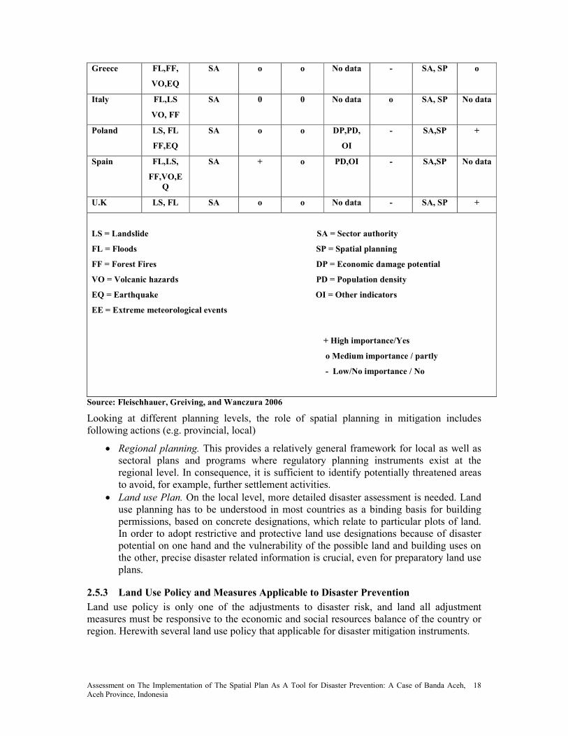
Assessment on The Implementation of The Spatial Plan As A Tool for Disaster Prevention: A Case of Banda Aceh, Aceh Province, Indonesia
18
Greece FL,FF,
VO,EQ
SA o o o data - SA, SP o
Italy FL,LS
VO, FF
SA 0 0 o data o SA, SP o data
Poland LS, FL
FF,EQ
SA o o DP,PD,
OI
- SA,SP +
Spain FL,LS,
FF,VO,E
Q
SA + o PD,OI - SA,SP o data
U.K LS, FL SA o o o data - SA, SP +
LS = Landslide SA = Sector authority
FL = Floods SP = Spatial planning
FF = Forest Fires DP = Economic damage potential
VO = Volcanic hazards PD = Population density
EQ = Earthquake OI = Other indicators
EE = Extreme meteorological events
+ High importance/Yes
o Medium importance / partly
- Low/ o importance / o
Source: Fleischhauer, Greiving, and Wanczura 2006
Looking at different planning levels, the role of spatial planning in mitigation includes following actions (e.g. provincial, local)
• Regional planning. This provides a relatively general framework for local as well as sectoral plans and programs where regulatory planning instruments exist at the regional level. In consequence, it is sufficient to identify potentially threatened areas to avoid, for example, further settlement activities.
• Land use Plan. On the local level, more detailed disaster assessment is needed. Land use planning has to be understood in most countries as a binding basis for building permissions, based on concrete designations, which relate to particular plots of land. In order to adopt restrictive and protective land use designations because of disaster potential on one hand and the vulnerability of the possible land and building uses on the other, precise disaster related information is crucial, even for preparatory land use plans.
2.5.3 Land Use Policy and Measures Applicable to Disaster Prevention
Land use policy is only one of the adjustments to disaster risk, and land all adjustment measures must be responsive to the economic and social resources balance of the country or region. Herewith several land use policy that applicable for disaster mitigation instruments.

Assessment on The Implementation of The Spatial Plan As A Tool for Disaster Prevention: A Case of Banda Aceh, Aceh Province, Indonesia
19
a. Zoning
Theoretically, the primary purpose of zoning is to segregate uses that thought to be incompatible. Zoning is commonly controlled by local government such as counties and municipalities, though the nature of zoning regime may be determined or limited by state or national planning authorities or through enabling legislation. Zoning may include regulation of the kinds of activities which will be acceptable on particular lots (open space, residential, agricultural, commercial or industrial), the densities at which those activities can be performed (from low – density housing such as single family homes to high density such as high rise apartment buildings), the height building, type of land use according to set back the building from the shoreline and most vulnerable locations and of course density occupancy buildings. The percentage of lot occupancy might be regulated so as to place residential development of various types away from the coastline reserving it for other uses not requiring permanent occupancy (UN, 1978)
b. Building Codes
Building codes as one of the regulatory instruments establish minimum standards of design, construction and material in order to avoid structural collapse under conditions of severe physical stressed caused by extreme natural phenomena. Although building codes are extremely important for mitigating the effects of natural phenomena, they should not be considered from land use controls, especially zoning. The coordination of land use controls and building code is one of the most effective local level devise for disaster prevention and mitigation. For example, the delineation of three zones in the earthquake prone areas provides only a partial solution to the risk of disaster damage. These controls should be supplemented by careful controls over building design, construction and materials with specific requirement according to the zone considered. Standards for structural resistance of buildings are directly correlated with the level of risks identified by the risk micro zoning maps and maps and associated land use maps and measures. (Maryland code, 2006)
c. Encroachment Lines
Encroachment lines function as a boundary line. In Indonesia, encroachment line or GSB “Baris Sembapan Bangunan” is basically the limit where the buildings can be built from the front of the land boundary, or border River or other natural boundaries. Demarcation line or directly in practice usually called 'border' is useful so that each home is built with concern for the environment (UN, 1978)
d. Relocation
Relocation which also called resettlement is the transportation of people (as a family or settlement) to a new settlement (as after an upheaval of some kind). In most cases, relocation is very difficult to implement. This is because relocation has to consider important aspects such as public services, support to livelihoods, provision of land and planning standard (UN Habitat, 2005)
• Public services: New locations may require government to establish a set of public services ranging from health to postal services. The cost of providing and running these services (investment and operating) can be considerable. Where possible and feasible new settlements should be located in relation to existing system of urban centers so that they enjoy ready access to the range of services.
• Support to livelihoods: New settlers undergo severe stress in the first 3 to 5 years as they struggle to build their families and community. A carefully designed livelihood

Assessment on The Implementation of The Spatial Plan As A Tool for Disaster Prevention: A Case of Banda Aceh, Aceh Province, Indonesia
20
support system is required so that the settlers can establish themselves as quickly as possible
• Land: Housing plots or homesteads are symbol of family identity and, in a rural setting, the most important factor of economic production. Families put considerable investment on their land over an extended period before it can start yielding economic benefits. Therefore, families need to assured that their investment does not go in vain because of a government policy. In this sense, adequate form of tenure security is critical to the sustainability of the settlement. Also, since families will invest their time and saving in building their houses, they should have an adequate form of tenure security for them to make this kind of investment worthwhile
• Provision of land: In all probability land for new settlements will have to be “bought” by the government. This is truer in the case of Indonesia where land administration is weak, cumbersome and fraught with lack of scientifically verifiable information. Consideration should be given to existing landowners from whom the land has been acquired so that they are unduly affected and their livelihood sources are not depleted.
• Planning standards: Decision to relocate a settlement desires bringing some forms of improvement vis-à-vis existing settlement. One consideration could be added protection against natural and/or manmade disasters. Another consideration could be the desire to start afresh and give the settlement a new living standard. While these objectives are laudable they take time to formulate and implement. Careful examination of options is warranted so that the risk of failure is minimized and undue investments are avoided. For instance, protection against Tsunami can be increased by implementing range of engineering and non-engineering measures: dikes, spurs, relocating to higher ground, early warning and public awareness in response to early warning, etc. Similarly, planning standards (road width, public open space, plot sizes, range and level of services, etc.) have cost and utility implications. A high planning standard can be slow to implement not only because of investment required but also for the fact that there may not be demand for such a standard. As a matter of principle any new planning standards should not differ much from existing standards. Similarly, if new settlements are designed with cost recovery in initial investment and operation in mind, the chances that they will be sustainable is higher.
In Aceh itself, according to UN-HABITAT (2005), there are four types of relocation may be existed:
• Relocation of the entire settlements where they have been largely destroyed by the disaster
• Readjustment within the existing settlements where they have been partially destroyed
• Settlement upgrading where settlements have been partially destroyed and the scope for in-situ reconstruction is feasible
• Preparation of interim sites where transition housing is being built

Assessment on The Implementation of The Spatial Plan As A Tool for Disaster Prevention: A Case of Banda Aceh, Aceh Province, Indonesia
21
Box 2.1 Green Belt Policy and Spatial Planning
The green belt is the zone of protected mangrove which is maintained all along the coast and which it is forbidden to cut down, convert or damage. The function of this mangrove green belt, in principle, is to preserve the coast from the threat of erosion and to act as a nursery and breeding ground for a variety of fish species.
Government policy to formulate a green belt began in 1975 with the publication of a decree by the Director General for Fisheries (SK Dirjen Perikanan No H.I/4/2/18/ 1975) which pronounced the need to maintain a belt of land along the coast, with a width of 400m measured from the average low tide level. The Director General for Forestry subsequently issued decree No. 60/KPTS/DJ/I/ 1978 concerning guidelines for silviculture in areas of brackish water. This decree stipulated a 10m wide green belt along the length of rivers, and a 50m-wide one along the coast, measured from the lowest point at low tide.
In 1984, the Forestry and Agriculture ministers issued joint decrees No. KB 550/246/ KPTS/1984 and No. 082/KPTS-II/1984, which called for the conservation of a 200m wide green belt along the coast, forbade the felling of mangrove trees in Java, and placed a conservation order on all mangroves growing on small islands (less than 1,000 ha.)
In 1990, Presidential Decree No. 32 concerning the Management of Conservation Areas replaced all previous regulations on green belt and granted more satisfactory protection to green belt zones. The decree stipulated that coastal mangrove green belt should be a minimum of 130 times the average tide, measured landwards from the point of the lowest tide mark. In practice, however, this decree suffered from a number of weaknesses as regards its application in the field. Some of the criticisms leveled at the decree are as follows:
• The decree cannot be applied to areas which, as a result of exploitation or conversion at some time in the past,
no longer possess mangroves. Provision has to be made for this.
• This decree cannot be used to make an effective determination of green belt on very wide flat shores or mud
flats. In several such areas, if the green belt is measured from the lowest point at low tide, it will comprise
nothing but mud flats and will not reach as far as the mangroves. This problem can be solved by having a
definition of measurement that starts from the seaward edge of the mangrove.
• This decree does not press for the protection of mangroves as a whole nor of their ecological function. It
disregards their ecological interdependence with, for example, terrestrial mangrove, freshwater sources or
freshwater swamps. Unless the supporting ecosystems are also protected in a properly integrated manner, the
future survival of the green belt will be at risk.
• This decree gives only one choice, conservation. This choice is inadequate for areas where the intensive
utilization of mangroves has long been a tradition, with the result that it will be difficult to reach consensus on
the management of mangroves in such areas. In Java, for example, almost the entire mangrove area has been
utiized by the inhabitants for aquaculture ponds and for a variety of other uses which do not, infact, support
mangrove conservation.
In 1993, the Forestry Department advocated that the total extent of protected areas needed to be doubled from 15 million to 30 million hectares. This was relevant to much of the nation’s mangroves. In response, a variety of organizations active in the field of nature conservation submitted proposals for new conservation areas and extensions to existing ones. One proposal for an additional 630,000 hectares of mangrove to be conserved was submitted by the Asian Wetland Bureau / Wetlands International – Indonesia Programme in 1994.
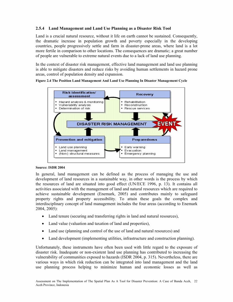
Assessment on The Implementation of The Spatial Plan As A Tool for Disaster Prevention: A Case of Banda Aceh, Aceh Province, Indonesia
22
2.5.4 Land Management and Land Use Planning as a Disaster Risk Tool
Land is a crucial natural resource, without it life on earth cannot be sustained. Consequently, the dramatic increase in population growth and poverty especially in the developing countries, people progressively settle and farm in disaster-prone areas, where land is a lot more fertile in comparison to other locations. The consequences are dramatic; a great number of people are vulnerable to extreme natural events due to a lack of land use planning.
In the context of disaster risk management, effective land management and land use planning is able to mitigate disasters and reduce risks by avoiding human settlements in hazard prone areas, control of population density and expansion.
Figure 2.4 The Position Land Management And Land Use Planning In Disaster Management Cycle
Source: ISDR 2004
In general, land management can be defined as the process of managing the use and development of land resources in a sustainable way, in other words is the process by which the resources of land are situated into good effect (UN/ECE 1996, p. 13). It contains all activities associated with the management of land and natural resources which are required to achieve sustainable development (Enemark, 2005) and contributes mainly to safeguard property rights and property accessibility. To attain these goals the complex and interdisciplinary concept of land management includes the four areas (according to Enemark 2004, 2005):
• Land tenure (securing and transferring rights in land and natural resources),
• Land value (valuation and taxation of land and properties),
• Land use (planning and control of the use of land and natural resources) and
• Land development (implementing utilities, infrastructure and construction planning).
Unfortunately, these instruments have often been used with little regard to the exposure of disaster risk. Inadequate or non-existent land use planning has contributed to increasing the vulnerability of communities exposed to hazards (ISDR 2004, p. 315). Nevertheless, there are various ways in which risk reduction can be integrated into land management and the land use planning process helping to minimize human and economic losses as well as

Assessment on The Implementation of The Spatial Plan As A Tool for Disaster Prevention: A Case of Banda Aceh, Aceh Province, Indonesia
23
environmental degradation due to disasters. Among others, the following tools and strategies of land use and land development can be mentioned:
• Identification of disaster-prone areas as well as alternative sites that are more suitable for development,
• Controlling the type of land use and land development in such areas (by land use regulations and building codes),
• Retrofitting and building of settlements and homes adapted to disaster conditions,
• Relocation of population vulnerable to disasters,
• Engineering measures and construction of hazard-resistant and/or protective structures and infrastructure.
In addition to these direct measures of land management to reduce the physical vulnerability of households and infrastructure, indirect measures can be a center for sustainable development and risk mitigation:
• Social benefit through public participation in land use management practices,
• Precautionary environmental protection by reduction of soil sealing and by protection of environmentally sensitive areas as well as
• Economic viability through decentralized development with a poly-centric settlement structure (Kötter 2003).
As described above, a comprehensive approach and integrative of methods for disaster reduction on the one hand and the strategies of land use planning and land management on the other hand is missing so far. Improved land use and land management strategies and instruments are needed to combine the land administration/cadastre/land development function with the process of disaster risk management. Therefore, particularly security of land tenure, access to land and control of land use in hazard-prone areas are vital issues to minimize vulnerability of populations to future crisis and disasters. This includes adoption and creation of a comprehensive policy on land management with regard to disaster prevention and mitigation as well as sustainable development figure 2.5.

Assessment on The Implementation of The Spatial Plan As A Tool for Disaster Prevention: A Case of Banda Aceh, Aceh Province, Indonesia
24
Figure 2.5 Sustainable Land Use Management As A Tool For Risk Reduction
Source: modified, according to Enemark 2004, p. 8)
However, the first steps in achieving these goals have been taken. Institutional and public awareness is increasing. The implementation of sustainable land management will facilitate to promote economic and social development in both urban and rural areas and will lead to a better disaster reduction.
Whereas current disaster management strategies tend to prefer structural measures (engineering approach), one can see a change of paradigm towards non-structural measures such as land use and building regulations or special disaster legislation. Concerning flood prevention, for example, the key objective is to leave more room for rivers, particularly for their natural flood plains, or to give the space back to them. To achieve this goal, measures for moving dikes further away from river banks as well as conservation or restoration of flood plains have to be implemented in the flood protection strategies. This includes certain restrictions on the construction of buildings in areas classified as “at risk of flooding” and agricultural use in high-risk areas (Friesecke, 2004).
2.5.5 Good Practice Example: Flood Prevention by Land Consolidation
Land consolidation can be an effective mechanism in rural development for preventative risk reduction. On the one hand, it can help the creation of competitive agricultural production arrangements by enabling farmers to have farms with fewer parcels that are larger and better shaped, and to expand the size of their property. But, on the other hand, because of the growing importance of flood protection, land consolidation has become an increasingly important instrument in increasing water storage capacity, redeveloping flood plains and denaturalizing rivers.
In reference to flood risk management, efficient and long-term land consolidation combines water management, regional planning and rural development, agriculture and nature conservation measures in an interdisciplinary concept.
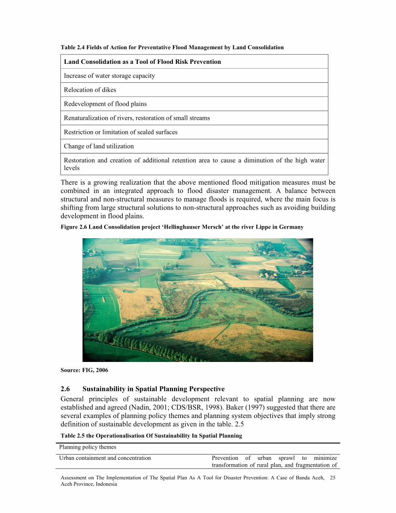
Assessment on The Implementation of The Spatial Plan As A Tool for Disaster Prevention: A Case of Banda Aceh, Aceh Province, Indonesia
25
Table 2.4 Fields of Action for Preventative Flood Management by Land Consolidation
Land Consolidation as a Tool of Flood Risk Prevention
Increase of water storage capacity
Relocation of dikes
Redevelopment of flood plains
Renaturalization of rivers, restoration of small streams
Restriction or limitation of sealed surfaces
Change of land utilization
Restoration and creation of additional retention area to cause a diminution of the high water levels
There is a growing realization that the above mentioned flood mitigation measures must be combined in an integrated approach to flood disaster management. A balance between structural and non-structural measures to manage floods is required, where the main focus is shifting from large structural solutions to non-structural approaches such as avoiding building development in flood plains.
Figure 2.6 Land Consolidation project ‘Hellinghauser Mersch’ at the river Lippe in Germany
Source: FIG, 2006
2.6 Sustainability in Spatial Planning Perspective
General principles of sustainable development relevant to spatial planning are now established and agreed (Nadin, 2001; CDS/BSR, 1998). Baker (1997) suggested that there are several examples of planning policy themes and planning system objectives that imply strong definition of sustainable development as given in the table. 2.5
Table 2.5 the Operationalisation Of Sustainability In Spatial Planning
Planning policy themes
Urban containment and concentration Prevention of urban sprawl to minimize
transformation of rural plan, and fragmentation of

Assessment on The Implementation of The Spatial Plan As A Tool for Disaster Prevention: A Case of Banda Aceh, Aceh Province, Indonesia
26
urban services, often linked to increased densities
and reuse of vacant urban land
Mixed use development Promoting diversity of land uses within neighborhoods and properties, making more efficient use of land resources, and the neglect of simple zoning
Creation of open space and water networks Protection and enhancement of important
environments, promoting flows through linking green spaces and open water
The planning system
Policy integration Establishing horizontal integration amongst sector
and vertical of levels of planning to establish commitment to common policies across government
Participation Enabling the involvement and empowerment of stakeholders in policy formulation and
implementation to generate ownership and meets special needs
Capacity building Ensuring that regional and local institutions had resources and skills to address sustainability, and the promotion of inter professional working
2.7 Sustainable Development and Disasters
Sustainable development offers a promising public policy perspective for guiding decisions to build more disaster-resilient societies and communities. The committee’s intent is to define sustainable development and discuss how this concept can be applied in ways that integrate disaster and development issues.
The vision of sustainability has influenced the formulation of a generation of international initiatives and also the thinking of hazards and disaster researchers and policy makers that followed the 1987 WCED report. The importance of natural disasters in devising sustainable development strategies was recognized by the United Nations resolution declaring the 1990s as the International Decade for Natural Disaster Reduction (IDNDR). This resolution helped galvanize support for incorporating disasters into development initiatives by stipulating that member nations establish a national program for a decade of disaster loss reduction. The successor to IDNDR, the International Strategy for Disaster Reduction (ISDR), which was created by the United Nations in 2000, promoted the sustainability agenda by focusing on the integration of citizen participation, awareness building, and consensus with technical disaster risk assessment.
The United Nations Commission on Sustainable Development (2001:2) recently stated the linkage between disasters and sustainability succinctly: Can sustainable development, along with the international instruments aiming at poverty reduction and environmental protection, be successful without taking into account the risks of natural hazards and their impacts? Can the planet take the increasing costs and losses due to natural disasters? The short answer is no.
Hazards and disaster researchers have proposed various conceptualizations of the links between disasters and sustainability premised on disaster resiliency. The concept of resilience

Assessment on The Implementation of The Spatial Plan As A Tool for Disaster Prevention: A Case of Banda Aceh, Aceh Province, Indonesia
27
has long been a tradition in ecology (Holling, 1973). Resilience, whether for individual organisms or communities, is based on accommodation and ability to adapt to a disturbance from a change agent, such as vector-borne diseases, over-harvesting, pollution, fires, and hurricanes. The idea of resilience is increasingly present in social science analysis, and in developing a theory for linked social-ecological processes. In the context of disasters, the concept of resiliency denotes strength, flexibility, and the ability to deal with a loss or misfortune and recover quickly. Mileti (1999b:5) defines disaster resiliency as the capacity to “withstand an extreme natural event with a tolerable level of losses” and taking “mitigation actions consistent with achieving that level of protection.” Bruneau et al. (2003:735) define community disaster resiliency as “the ability of social units (e.g., organizations, communities) to mitigate hazards, contain the effects of disasters when they occur, and carry out recovery activities in ways that minimize social disruption and mitigate the effects of future [disasters].” Chang and Shinozuka (2004) extend this definition by conceptualizing, measuring, and evaluating resiliency of a community to earthquakes along four interrelated dimensions: technical, organization, social and economic. Other definitions stress the role of city and regional planning in creating resilient natural and built environmental systems (Godschalk, 2003) and cultural values related to historic meanings of resilience and urban trauma (Vale and Campanella, 2005).
It is possible to understand how several of the underlying principles of sustainable development outlined by the United Nation’s Agenda 21, the first United Nation’s agenda for action on sustainability, can be applied to disasters (Sitarz, 1993). These principles can be referred to as the four “E”s of sustainable development for disaster resiliency:
1. Ecological limits: Recognize that disasters are limiting environmental factors to development to ensure that basic health and safety needs essential to human development are met.
2. Equity:
• Intergenerational—Account for disasters to ensure efficiency in use of development funds that might otherwise not be available for future investment.
• Intergenerational—Improve equity within generations by providing for sufficient low-cost, low-risk development opportunities for the least advantaged.
3. Economic development: Sustainability means that living standards in the future will be higher than in the present and higher levels of development will be associated with greater mitigation and emergency preparedness.
4. Engagement: Development actions that address disaster reduction (and other significant issues) must be formulated through a fair and equitable process that provides an opportunity for all affected parties to participate.
Spatial and social scale is an important factor in translating these principles into practice. Local issues may be quite different, but are often inextricably linked to global processes. For example, global warming may increase the spread of infectious diseases and threaten food production systems at the regional and local scales. At the same time, global processes may be affected by local land-use decisions that support greater dependence on automobiles and increased CO2 emissions, which contribute to global climate change. As scale changes, the

Assessment on The Implementation of The Spatial Plan As A Tool for Disaster Prevention: A Case of Banda Aceh, Aceh Province, Indonesia
28
disaster mitigation tools change. For example, urban infrastructure investments and land-use plans can shape urban forms and reduce the dependence on cars, while individual countries will be less likely to enact more stringent emission standards unless negotiated international agreements are ratified.
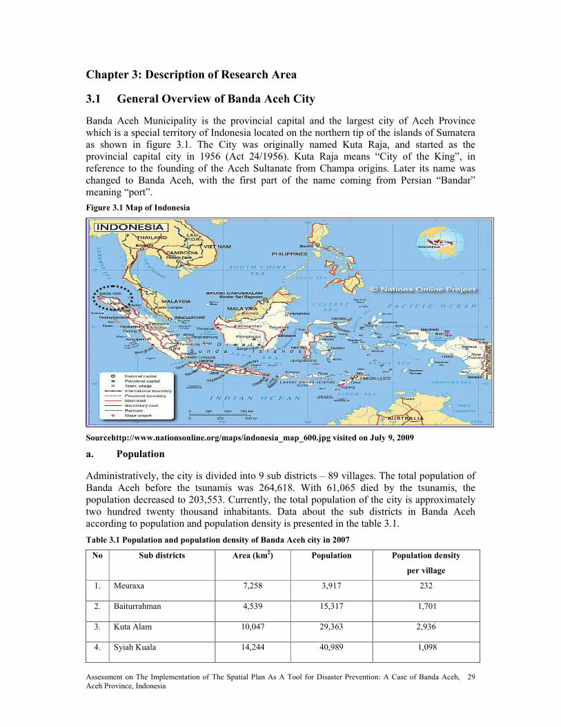
Assessment on The Implementation of The Spatial Plan As A Tool for Disaster Prevention: A Case of Banda Aceh, Aceh Province, Indonesia
29
Chapter 3: Description of Research Area
3.1 General Overview of Banda Aceh City
Banda Aceh Municipality is the provincial capital and the largest city of Aceh Province which is a special territory of Indonesia located on the northern tip of the islands of Sumatera as shown in figure 3.1. The City was originally named Kuta Raja, and started as the provincial capital city in 1956 (Act 24/1956). Kuta Raja means “City of the King”, in reference to the founding of the Aceh Sultanate from Champa origins. Later its name was changed to Banda Aceh, with the first part of the name coming from Persian “Bandar” meaning “port”.
Figure 3.1 Map of Indonesia
Sourcehttp://www.nationsonline.org/maps/indonesia_map_600.jpg visited on July 9, 2009
a. Population
Administratively, the city is divided into 9 sub districts – 89 villages. The total population of Banda Aceh before the tsunamis was 264,618. With 61,065 died by the tsunamis, the population decreased to 203,553. Currently, the total population of the city is approximately two hundred twenty thousand inhabitants. Data about the sub districts in Banda Aceh according to population and population density is presented in the table 3.1.
Table 3.1 Population and population density of Banda Aceh city in 2007
o Sub districts Area (km2) Population Population density
per village
1. Meuraxa 7,258 3,917 232
2. Baiturrahman 4,539 15,317 1,701
3. Kuta Alam 10,047 29,363 2,936
4. Syiah Kuala 14,244 40,989 1,098

Assessment on The Implementation of The Spatial Plan As A Tool for Disaster Prevention: A Case of Banda Aceh, Aceh Province, Indonesia
30
5. Ulee Kareng 6,150 23,083 2,564
6. Banda Raya 4,789 43,746 3,976
7. Kuta Raja 5,211 4,639 773
8. Lueng Bata 5,341 30,867 3,086
9. Jaya Baru 3,780 27,936 3,104
Total 61,359 219,857 2,440
Source: Statistical Bureau of Banda Aceh Province (2008)
b. Topography
Banda Aceh is a coastal city with land ranging from –0.45 to 4.5 m above sea level. Land surface form is relatively flat with slope between 2 – 8% indicates that Banda Aceh is less potentially to erosion. With parts of the city below mean sea level (MSL), the city suffers frequent flooding during heavy rains and high tide especially in North or coastal area. To cope with this problem the city has built flood control canals and pumping stations on its west side. The Krueng Aceh River runs through the city center.
c. Disaster Impact
Had long suffered from 30 years of armed conflict between the Free Aceh Movement and the Government of Indonesia before finally signed the peace agreement on 15 August 2005 and until December 26, 2004, Banda Aceh was not frequently subjected to International discussion. On the day the Indian Ocean earthquake struck off the western coast of Sumatra. Banda Aceh was the closest major city to the earthquake’s epicenter, and suffered further damage when a tsunami hit shortly afterwards. The disaster was one of the biggest in the modern history and had caused 70,000 of causalities corresponding to 27% of population before disaster and more than 12,000 of house damage (JICA, 2005). The estimated extent of tsunami inundation zone reached 6, 32 km2 within the densely populated area of the city. In addition to the human loss, the disaster has also brought enormous impact to infrastructures, environment, socio-culture and economy to the city. The World Bank’s preliminary assessment reported that the total damage and losses was USD 4.5 billion, both for public and private sectors (Bappenas, 2005).
Approximately, 73.7% of 3,859.51 ha settlements area has been destroyed. The 18,811 units of which is residential buildings and 2,442 units is others building with various degrees of damages. Most houses within 100 meters of the shore it spelt disaster dwellings, infrastructure and livelihood.
d. Social and Cultural Environment
Referred to as the “port of Meccah” as Islam first arrived in Aceh before spreading throughout Southeast Asia, People in Banda Aceh assembling of Islam law is not the new things. Historically been staunchly Islamic, on 1 January 2002, as part of wide ranging autonomy package, Aceh was granted the right to adopt Islamic law or Syariah law. Appreciation as the exclusiveness of Aceh with their Islamic law is cleared by government regulation number 1, 2006 about the Aceh government, it is included that Al-Syakhsiyah field (family law, it is like marriage, divorce, legacy, guardianship, basic necessities of life and commons property), Mu’amalah (customs and manners problems in daily life, it is like trade, feint and borrow), and Jinayah (criminality) which is based on Islamic law and
Assessment on The Implementation of The Spatial Plan As A Tool for Disaster Prevention: A Case of Banda Aceh, Aceh Province, Indonesia
31
arranged by Qanun (local regulation ) or used to called PERDA in other provinces in Indonesia.
e. Local Economic Development
Economic Development Banda Aceh’s rapid growth is not only triggered by the fact that Banda Aceh as the capital of the province, the center administrative affairs, political, and economic activities, but also as the center of education. All of these came out to be the attractions for people from rural areas in the province to come to Banda Aceh city. In general, Banda Aceh's economy is dominated by the trade and services activities mostly small medium enterprises, government services, and tourism in addition to the fishery (fishermen and farmers). Growth in Aceh’s non-oil and gas economy declined sharply in 2008 as the reconstruction effort winds down. As many reconstruction actors (NGOs, GoI) wind down or significantly scale down their operations in the city, sectors linked to the reconstruction effort that had led growth in Banda Aceh since 2005 registered low or negative growth rates (World Bank, 2009). Inflation continues to decline in 2006 the inflation rate is 2,19. Inflationary pressures have subsided together with the global slump in demand. The end of the reconstruction effort and the demand this created for goods and services, together with the slowing of Aceh’s economy, have contributed to the lowest inflation rate in over four years (World Bank, 2009).
f. Land Tenure
The disaster also severely affected local systems of land administration. The tenure insecurity increased because most of the land records were severely damage. The primary formal mechanism for establishing tenure security for establishing tenure security after the tsunami is the Reconstruction of Land Administration System (RALAS). The program is to systematize the land title certification based on community driven adjudication of land rights. Each landowner signed a statement of ownership that is endorsed by her neighbor and village head or called Keuchik as a localized evidence of land record. If the landowner deceased, RALAS manual established a procedure of identification of heirs by Keuchik or Village Imam. This process involves the family member completing a standard form that identifies the heirs and the land that they inherited. This agreement is acknowledge by both village head and Imam, and confirmed by Syariah Court. Once the community given adjudication is completed, a team from BPN surveys land boundaries and verifies the accuracy of all community agreement. After surveying and verification has been completed, BPN produced community land map that list the landowners and the boundaries of their land. This map is displayed in the village for 30 days in which time village members may lodge relevant objection. If no objections have been raised within the 30 day period, BPN will issue land certificates to designated land owners.
3.2 Meuraxa Sub District
Located approximately five kilometer from the capital City Banda Aceh and only few hundred meters from the coastline of Ulee Lhee, Meuraxa is one of the worst tsunami affected sub districts of all Aceh. Consisting of 16 villages, over 85% of the community perished in the tsunami. The majority of survivors were men and the majority of those who died were women, children and elderly.
a. Ulee Lhee
Prior to the tsunami of December 2004, Ulee Lheue Island was a thriving fishing port, residential and government agency area with a population of approximately 1,500 people.The

Assessment on The Implementation of The Spatial Plan As A Tool for Disaster Prevention: A Case of Banda Aceh, Aceh Province, Indonesia
32
tsunami devastated the population of Ulee Lheue Island, reducing it from approximately 1500 to around 200. The island land mass was reduced from its previous 64ha to 52ha, with the total destruction of all houses, buildings, fish landing sites, public spaces, roads and vegetation. The pre-tsunami complex of traditional aquaculture ponds (tambak) and small stands of mangrove on the inland side of the island’s narrow waist were destroyed. A dramatic change in mean land level also occurred. The land sank, by about -0.7 m, in a low-lying area already experiencing flooding and drainage congestion problems (SP5 IEE, 2007).
b. Deah Baro
Deah Baro is small fishing village where 240 people survived out of a population of 2000.
c. Deah Glumpang
The location of Deah Glumpang is very close to the coastline and it was directly affected by the tsunami. About five hundred houses were completely washed away. Deah Glumpang consists of four smaller community and administrative units called 'dusun'. They are named Damai (Peace), Makmur (Prosperity), Sejahtra (Harmony) and Bahagia (Happiness). Table 3.2 shows population of each hamlet.
Table 3.2 Population of Deah Glumpang before and after Tsunami
Hamlet Before Tsunami After Tsunami per May 2008
Households Population Households Population
Damai 129 349 34 114
Makmur 152 384 37 151
Sejahtera 120 331 21 62
Bahagia 137 362 51 169
Total 538 1426 143 496

Assessment on The Implementation of The Spatial Plan As A Tool for Disaster Prevention: A Case of Banda Aceh, Aceh Province, Indonesia
33
Chapter 4: Research Method
4.1 Research Type and Strategy
The research type was using exploratory method, because it assembles preliminary information that helped to define problems and suggest hypotheses (Kotler et al, 2006). It also seeks to explore what is the story behind certain activity and to investigate social phenomena without explicit explanations (Schutt, 2006). This research method often relies on secondary study such as reviewing available literature or data, or qualitative approaches such as informal discussion with employees, management, and more formal approaches through in depth interviews, focus group, projective method, case studies or pilot studies.
The main research strategy of this study was a survey. This research strategy attempts to assess the effectiveness of the implementation of present spatial plan in minimizing the impact of future disasters in Banda Aceh.
4.2 Data Collection
4.2.1 Literature study
Relevant secondary data such as articles, reports, policy documents were collected through literature study from related governmental agencies in Banda Aceh as shown in the table 4.1
Table 4.1 Source of Secondary Data
o Secondary data Data source
1. Spatial plan of Banda Aceh - RTRW Kota Banda Aceh 2006 - 2026 Dinas PU Tata Ruang
2. Coverage area of coastal forest Forestry Agency
3. Number of building permits approved 2007 – 2009 for Banda Aceh Public Work
4. Building code Public Work
5. Data on mangrove coverage in Banda Aceh as buffer zone Forestry Agency
6. Guidelines for coastal regulation zone Department of Marine
Affairs and Fisheries
7. Map of land consolidation of Lambung villlage National Land Agency
4.2.2 Field work
Field work was conducted to collect primary data. The duration of the fieldwork was 30 days and started from 29th of June to 31st July 2009 in Banda Aceh city, Indonesia. The research instruments were a combination of in depth interviews and semi closed questionnaires.
For in depth interviews were applied. The choice of key respondents from government officials and experts was based on purposive sampling technique. The in depth interviews were carried out with semi structured format and the interviews were recorded with audiotape and written. The researcher increased the number of respondents for in depth interview from 5 to 11 people when the researcher found out that the valuable information from the head of Tsunami and Disaster Mitigation Research Centre). Further, the list of organizations interviewed is shown in the table 4.2. Copies of the interviews can be found in Annex 1.

Assessment on The Implementation of The Spatial Plan As A Tool for Disaster Prevention: A Case of Banda Aceh, Aceh Province, Indonesia
34
Table 4.2 List of Organizations of Key Respondents For In-Depth Interview
No. Organization Type Organization Responsibilities Number
1 Local Government City Council Plan for the development and evaluate the policies and programs of the municipality
1
2 Local Government Regional Development Planning Agency (BAPPEDA Kota Banda Aceh)
Responsible for monitoring and evaluating the spatial plan
1
3 Local Government Regional office of the Ministry of Environment (BAPEDAL)
Coordinate the supervision of land use planning
1
4 Local Government Public Works Conduct supervision of the land
use plan
3
5 University Syiah Kuala University Involved in development of spatial plan
1
6 University Tsunami Disaster Mitigation Research Center (TDMRC)
Conduct applied disaster reduction research
1
7 Local government National Land Agency Restraining the land use plan 1
8 Local Government Marine and Fisheries Agency Aceh Province
Coastal development planning 1
9 Legal Expert 1
Total 11
For semi-closed questionnaires, a purposive sampling technique was applied to the respondents. Purposive sampling is a form of non-probability sampling (Polit & Hunglar, 1999). It is a non-representative subset of some larger population, and is constructed to serve a very specific need or purpose. The questionnaires were disseminated directly to respondents in order to gather information. The disseminations of questionnaires were done by visiting village leaders’ offices in three respected villages to get list of respondent addresses and then visiting each house of the respondents.
The number of respondents was increasing from 30 to 45 respondents. The number List of respondents is shown in the table 4.3. Copies of questionnaire can be found in the Annex 2.
Table 4.3 List of Respondents for Semi Closed Questionnaire
o Respondents umber
1 Village leader 3
2 Community leader 5
3 Fisherman 11
4 Civil servant 5
5 Traders 7
6 Community member 9
7 Pond Farmer 5
8 Total 45
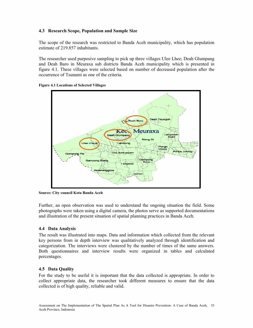
Assessment on The Implementation of The Spatial Plan As A Tool for Disaster Prevention: A Case of Banda Aceh, Aceh Province, Indonesia
35
4.3 Research Scope, Population and Sample Size
The scope of the research was restricted to Banda Aceh municipality, which has population estimate of 219.857 inhabitants. The researcher used purposive sampling to pick up three villages Ulee Lhee; Deah Glumpang and Deah Baro in Meuraxa sub districts Banda Aceh municipality which is presented in figure 4.1. These villages were selected based on number of decreased population after the occurrence of Tsunami as one of the criteria.
Figure 4.1 Locations of Selected Villages
Source: City council Kota Banda Aceh
Further, an open observation was used to understand the ongoing situation the field. Some photographs were taken using a digital camera, the photos serve as supported documentations and illustration of the present situation of spatial planning practices in Banda Aceh.
4.4 Data Analysis
The result was illustrated into maps. Data and information which collected from the relevant key persons from in depth interview was qualitatively analyzed through identification and categorization. The interviews were clustered by the number of times of the same answers. Both questionnaires and interview results were organized in tables and calculated percentages.
4.5 Data Quality
For the study to be useful it is important that the data collected is appropriate. In order to collect appropriate data, the researcher took different measures to ensure that the data collected is of high quality, reliable and valid.

Assessment on The Implementation of The Spatial Plan As A Tool for Disaster Prevention: A Case of Banda Aceh, Aceh Province, Indonesia
36
4.5.2 Validity
Validity is used to prove that the instruments measure what is supposed to measure. It is improved by collecting secondary data and triangulation technique of using interviews, questionnaire combine with observation.
4.5.3 Reliability
Reliability is degree of consistency between two measures. In order to ensure that data collected during fieldwork is reliable, there will be use more than one research tool. This will be supplemented by interviewing different level of institutions for the purpose of triangulating the collected data. Respondents will be asked different questions to seek similar information; samples will be asked the same question to determine degree of consistency between two measures. Measuring instruments consistence of the study, reliability is maintained.
4.6 Unit of Analysis, Variables and Indicators
4.6.2 Unit Analysis
The units of analysis of this study were sectors and departments of Banda Aceh municipality that directly involved and responsible for the implementation of spatial plan.
The study covered three villages in municipality with the aim of getting information from city residents. Therefore the unit of analysis of third point c and forth question are for community whereas the unit of analysis for the second and third point a & b questions is the institutional.
4.6.3 Variables/Indicators
The variables and indicators were operationalised through development of a theoretical framework for the study. The relationships between indicators are explained in table 4.4
Table 4.4 Variables and Indicators
o Research question Variables Indicators Data sources
1. How is the implementation of present spatial plan in Banda Aceh?
• RTRWK Banda
Aceh 2006 – 2016
• Field monitoring
/observation
a. Which mitigation measures are proposed in the present spatial plan of Banda Aceh?
mitigation measures
• Green infrastructures
• Conservation area
• Zoning instruments
• Restriction development areas
• Construction or location permits
• Encroachment lines
• Relocation
• Mixed use
RTRWK Banda Aceh 2006 – 2016
Literature review
spatial plan report
in depth interview with local government
b. What outputs have been achieved so far
in the period 2006 – 2009
Measurable output
• Change in hectares of land designated as urban open space.
• Hectares of land designated as buffer
• In depth interview
• report

Assessment on The Implementation of The Spatial Plan As A Tool for Disaster Prevention: A Case of Banda Aceh, Aceh Province, Indonesia
37
areas.
• Percentage of coastal zone area achieved
• Proportion of restoration coastal conservation area
c. Which factors influence the implementation of present spatial plan?
Participation • Number of community informed and involved in
the development process of spatial plan
• In depth interview
• Report
Institutional capacity
• number of planners
• level of responsibility of each department/sector
• In depth interview
• documents
Financial resources
• allocated budget • Documents from Dinas Tata Kota and Bappelda
• In depth interview
Legal • number of household complied with building code / permit (IMB)
• Number of dwellings
permitted in defined flood zones or risk areas identified
• Number of land use permit (IPR)
• Number of EIA documents issued
2 How effective is the implementation of present spatial plan in minimizing the impact of future
natural disasters at the city scale?
3 How can the local government improve the implementation of present spatial plan of Banda Aceh?
Act ivies undertaken
• Number of training given
• Number of
communication strategies
• Number of alternative solution
• Case study
• in depth interview
• questionnaire
• reports
• case study
4 What is public perception
toward the content and the implementation of present spatial plan in regard to mitigation measures in
Ulee Lhee, Deah Baro and Deah Glumpang?
public perceive • housing location
• quality of spatial structure
• Level information obtained
• Immediate outcome of the spatial plan to respected villages
4.7 Research Design
The research design provides guidance on the chorological order through which the researcher conducted the research. The research design consisted of some stages as is shown in the following figure 4.2

Assessment on The Implementation of The Spatial Plan As A Tool for Disaster Prevention: A Case of Banda Aceh, Aceh Province, Indonesia
38
Figure 4.2 Research Design
4.8 Limitation and challenges during field work
The study was mainly limited with the following:-
• The time constrain, this was attributed to the fact that a master research needed sufficient time for effective result and four weeks were inadequate time for fieldwork
• Limited budget leaded researcher to collect the primary data personally. The researcher was unable to employ research assistants in order to speed up the collection of data.
The researcher encountered a number of challenges during fieldwork which included the following:
• The respondents often changed the agreed time of the interview which affecting the other schedules that had been agreed with other respondents
• Most of the respondents of the questionnaire were not in their office or home when researcher came, therefore researcher has to back and forth several times in order to disseminate the questionnaire directly.
Problem
statement
Formulation of research
objectives & questions
Literature
review/theoretical
framework
Survey with
questionnaire
Field Work
(Primary data)
Data collection
Observation
Formulation
of research
method
Literature review
(secondary data)
In depth interview
Government agencies
Analysis data
Discussion of findings
Formulation of conclusion and recommendations

Assessment on The Implementation of The Spatial Plan As A Tool for Disaster Prevention: A Case of Banda Aceh, Aceh Province, Indonesia
39
Chapter 5: Result and Analysis
5.1 Introduction
The findings in this study attempt to answer the research questions formulated in order to answer the general objective. Therefore, in this chapter the researcher presents findings and discussions based on who leads and who is involved in the process of the present spatial plan formulation and what mitigation measures proposed in the present spatial plan. Further, discussions on the implementation of present spatial plan in mitigating of potential future disasters is analyzed by looking what output achieved so far from 2006 – 2009; factors influencing the implementation of the plan; public perception towards the content and the implementation of present spatial plan in three village in Meuraxa sub district and finally strategies that should be used to improve the effectiveness of the implementation of the present spatial plan in Banda Aceh.
5.2 Implementation of Present Spatial Plan
Successful plan implementation depends on meeting many conditions. One of the criteria of successful of plan implementation is sound spatial plan see chapter 2.3 p.18 in other word the quality of a plan. Therefore, in order to test the hypothesis of this study which is “the implementation of present spatial plan can effectively minimize risks of future natural disasters in Banda Aceh”, the researcher identified several mitigation measures proposed in the spatial plan through an interview method to assess the quality of the plan. During the field work, the researcher interviewed ten respondents.
5.2.1 Identification of Mitigation Measures Proposed in Spatial Plan of Banda Aceh
The interview results show that escape route and escape building are two main mitigation measures proposed in Banda Aceh spatial plan followed by buffer zone, zoning instrument such as restriction development zone, new urban development zone, zoning regulation, as well as green infrastructure. Finally, the respondents indicated that land consolidation is the last mitigation measure proposed in the spatial plan. List of mitigation measures could be seen in table 5.1 Detail explanations of each measure will be further discussed in the next sub chapter.
Table 5.1 Mitigation Measures Proposed in Banda Aceh Spatial Plan ( =10)
�o Measures Frequency Percentages (%)
1 Escape routes 6 15.79
2 Escape building 6 15.79
3 Open space 4 10.53
4 Restriction Development Zone 4 10.53
5 New Urban Development 4 10.53
6 Building regulation 3 7.89
7 Buffer zone 5 13.16
8 Zoning regulation 4 10.53
9 Land consolidation 2 5.26
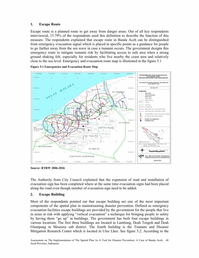
Assessment on The Implementation of The Spatial Plan As A Tool for Disaster Prevention: A Case of Banda Aceh, Aceh Province, Indonesia
40
1. Escape Route
Escape route is a planned route to get away from danger areas. Out of all key respondents interviewed, 15.79% of the respondents used this definition to describe the function of this measure. The respondents explained that escape route in Banda Aceh can be distinguished from emergency evacuation signal which is placed in specific points as a guidance for people to go further away from the sea wave in case a tsunami occurs. The government designs this emergency route to mitigate tsunami risk by facilitating access to safe area when a strong ground shaking felt, especially for residents who live nearby the coast area and relatively close to the sea level. Emergency and evacuation route map is illustrated in the figure 5.1
Figure 5.1 Emergencies and Evacuation Route Map
Source: RTRW 2006-2026
The Authority from City Council explained that the expansion of road and installation of evacuation sign has been completed where at the same time evacuation signs had been placed along the road even though number of evacuation sign need to be added.
2. Escape Building
Most of the respondents pointed out that escape building are one of the most important components of the spatial plan in mainstreaming disaster prevention. Defined as emergency evacuation facilities escape buildings are provided by the government for the people that live in areas at risk with applying “vertical evacuation” a technique for bringing people to safety by having them “go up” in buildings. The government has built four escape buildings in various locations. The first three buildings are located in Lambung, Deah Tengoh and Deah Glumpang in Meuraxa sub district. The fourth building is the Tsunami and Disaster Mitigation Research Center which is located in Ulee Lhee. See figure 5.2. According to the
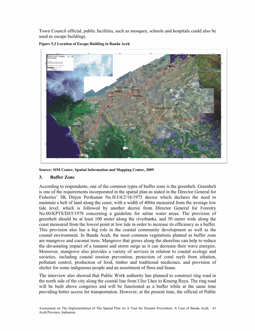
Assessment on The Implementation of The Spatial Plan As A Tool for Disaster Prevention: A Case of Banda Aceh, Aceh Province, Indonesia
41
Town Council official, public facilities, such as mosques, schools and hospitals could also be used as escape buildings.
Figure 5.2 Location of Escape Building in Banda Aceh
Source: SIM Center, Spatial Information and Mapping Center, 2009
3. Buffer Zone
According to respondents, one of the common types of buffer zone is the greenbelt. Greenbelt is one of the requirements incorporated in the spatial plan as stated in the Director General for Fisheries’ SK Dirjen Perikanan No.H.I/4/2/18/1975 decree which declares the need to maintain a belt of land along the coast, with a width of 400m measured from the average low tide level, which is followed by another decree from Director General for Forestry No.60/KPTS/DJ/I/1978 concerning a guideline for saline water areas. The provision of greenbelt should be at least 100 meter along the riverbanks, and 50 meter wide along the coast measured from the lowest point at low tide in order to increase its efficiency as a buffer. This provision also has a big role in the coastal community development as well as the coastal environment. In Banda Aceh, the most common vegetations planted as buffer zone are mangrove and coconut trees. Mangrove that grows along the shoreline can help to reduce the devastating impact of a tsunami and storm surge as it can decrease their wave energies. Moreover, mangrove also provides a variety of services in relation to coastal ecology and societies, including coastal erosion prevention, protection of coral reefs from siltation, pollutant control, production of food, timber and traditional medicines, and provision of shelter for some indigenous people and an assortment of flora and fauna.
The interview also showed that Public Work authority has planned to construct ring road in the north side of the city along the coastal line from Ulee Lhee to Krueng Raya. The ring road will be built above congeries and will be functioned as a buffer while at the same time providing better access for transportation. However, at the present time, the official of Public
Assessment on The Implementation of The Spatial Plan As A Tool for Disaster Prevention: A Case of Banda Aceh, Aceh Province, Indonesia
42
Work commented that the construction of the road has not yet started due to land acquisition problems.
4. Restriction Development Zone
The respondents revealed that restriction development zone is one of the approaches from the government to minimize the risk of potential future disasters. This zone is proposed by the government as an alternative solution due to weaknesses from the government of Aceh to implement the policies indicated in the Blue Print - Blue Print is a Master Plan prepared by Ministry of National Development Planning as a reference for the preparation of Aceh and Nias rehabilitation and reconstruction follow up plan in the longer run- during the rehabilitation and the reconstruction phases. The Blue Print policy called that all surviving households to be relocated to a new settlement which is 10 – 30 kilometers inland and move the city away between 3.5 – 5 kilometers from the shoreline. The policy also stated that there would be no infrastructures allowed to be built in this zone.
However, all strategic plans to materialize the move could not be implemented due to some constraints: First, there were insufficient budgets from the government to relocate all tsunami survivors during the early stage of the reconstruction; while at the same time many of donor agencies who were not well informed of the Blue Print policy, were keen to build back new houses for the survivors in their previous land plots. Second, many of the survivors were not willing to move to the new settlement because of their occupation background, particularly community that lived close to the coast and work as fishermen, though the Aceh Reconstruction and Rehabilitation Authority – BRR had then already established relocation project since early 2006 in order to accommodate the move of the people to safer zone as indicated in the Blue Print. Third, according to Public Work Officials, lack of coordination efforts from many of Non-Governmental Organizations during the reconstruction stage created more challenges for the government to conduct a proper zoning plan which is aligned with the Blue Print’s requirements.
Based on the aforementioned challenges and several other considerations, such as the high number of pre-disaster population distribution, the number of projected population growth, the resources to support the environment, the future strategic plans and the high level of vulnerability to disasters makes the government to propose restricted development zone in two villages (Ulee Lhee and Lambaro) situated in the old town that are located less than 1km from coast line.
The government assigned 8, 08 percent or 495, 56 Ha land use from the total areas of Banda Aceh with population density ranged from 1 – 40 people/ha as the restriction development zone. With regards to infrastructure planning, the government will invest more in infrastructures which are vital in helping the local communities to accelerate their economic life. For example, fishing port and fish processing industries will be constructed to revitalize the fishing industry sector.
5. ew Urban Development Zone
New urban development zone was mentioned by respondents as a measure applied in the spatial plan which intends to steer development to the southern part of the city. The Authority of City Council and Regional Development Planning Board of Banda Aceh explained that this approach provides incentives for the citizens – one of them is to live in safer locations. Three motivations for this side of the city to be considered as a new development zone:
• This area was not affected by tsunami. Physiologically; community who lives in this area will feel more secure.

Assessment on The Implementation of The Spatial Plan As A Tool for Disaster Prevention: A Case of Banda Aceh, Aceh Province, Indonesia
43
• People can take this as an incentive to reallocate from risky areas to safe areas.
• There are plenty of lands to build and expand new settlements and to develop the needed public facilities. In fact, several public facilities and offices have already been directed to this new zone.
6. Open Space Control
According to the respondents, open space have to be incorporated in the spatial plan as one of the requirements stated in Act No.26/2007 which refers to the 30 percent provision of open space of the total areas of each region or city. Open space also serves a function of an evacuation zone. Moreover, as the respondents pointed out, that a green open space, like a soccer field, for instance, will be able to absorb excess water from the rain or floods which is also beneficial for the environment as it can collect and store water.
7. Land Consolidation
Land consolidation is proposed as one of mitigation measures to implement the spatial plan. It is also one of instruments used to minimize risk of future disasters as it can help with the change of land use pattern for village renewal after the occurrence of natural disasters, like Tsunami or severe floods. However, no literature explicitly indicates that land consolidation can be incorporated in the spatial plan. In most cases, a spatial plan is needed to prepare land consolidation process. Land consolidation is a mitigation measure itself which is used to implement a spatial plan and therefore cannot be incorporated into the spatial plan.
5.2.2 Categorization of Measures
Based on all mitigation measures summarized above and type of problems, the researcher would like to categorize those measures into two broad prevention measures, which are Structural Measures and Non-Structural Measures.
1. Structural Measures
There are two types of structural measures applied in Banda Aceh spatial plan. Physically, the escape building and the escape road could be categorized as hard protection measure because this type measure is artificially made or manmade. The vegetation green belt that is used to serve as a buffer zone is categorized as soft protection measure. Both of these measures set up in the spatial plan, as shown in figure 5.3 and 5.4 to prevent and protect residential and commercial zone from natural disasters. This explanation is also supported by several key respondents from local government agencies who had been interviewed.
2. Non-Structural Measures
Figure 5.4 Signage Figure 5.3 Escape Building
Source: Fieldwork July 2009

Assessment on The Implementation of The Spatial Plan As A Tool for Disaster Prevention: A Case of Banda Aceh, Aceh Province, Indonesia
44
Meanwhile, there are five types of non-structural measures applied in Banda Aceh spatial plan. The measures are restriction settlement/development zone, new development zone, buffer zone, building code and land consolidation. Those mentioned measures are categorized in non structural measures due their spatial dimension shown in Annex 4.
5.2.3 Measurable Output Achieved 2006 – 2009
Most of respondents in interview shared the experiences of infrastructure plan implementation. In fact, it is one of most important components of the implementation of spatial plan. The local government with Donor agencies has invested in most crucial part of infrastructures that can help local communities to reduce the vulnerability to natural disasters. For example the village roads were expanded to enhance the mobility of villagers during particularly the evacuation in case of earth quake. The table 5.2 shows different type of disaster mitigation related activities and sectoral agencies involved in the implementation of spatial plan in Banda Aceh.
Table 5.2 Actual Infrastructure Plan
Year �ew Town Restriction Development zone
Plan Implementation Plan Implementation
2007 Construction of 3 escape
building
completed
2008 Construction of embankment along coastline
completed
Construction of Tsunami
and Disaster Mitigation research center
Completed
2009 Provision of a public Market
10% Provision of a public Market
Not yet implemented
Two road construction @ 3km and 2 km
90% completed
Build 1 New
public terminal
Completed
Build 1 Public Hospital
completed
7 Kolam
tendon (pond) constructed
completed
Expansion of village road completed
Ring road in the south
Not yet started due to land acquisition
Ring road in the north Not yet started due to land acquisition

Assessment on The Implementation of The Spatial Plan As A Tool for Disaster Prevention: A Case of Banda Aceh, Aceh Province, Indonesia
45
5.2.4 Factor Influencing the Implementation of Spatial Plan
Until today, the new spatial plan is not yet approved, as explained by the responsible government officials. This condition is the main factor that creates delays of the current implementation of spatial plan in Banda Aceh. However, there are several reasons why the spatial plan is not yet approved until today.
First, it was understood that at the preparation stage of the spatial plan the consultants assigned by the BRR has made fatal inaccuracy in the spatial plan that has led to a long revision. It was confirmed that about fifty percent or more of the plan is a copy-paste from the previous plan and other sub district data. In addition, the various plans such as roads and sidewalks are not in accordance with the conditions of Banda Aceh at the moment and the development for the next 10 or 15 years. This problem appeared because of the limited involvement of related institutions in giving feedback and suggestions during the process.
In fact, one of the interviewee from spatial planning department of public work mentioned that they only got involved in the preparation stages. The BRR once invited them to an ad hoc meeting and workshop as the need arisen. The public work authorities further explained many of their suggestions were also not accommodated in the plan. As a result, Public Work as a leading agency that is responsible for the implementation of spatial plan needs to revise the draft spatial plan due to the confusions caused by the BRR consultants.
Second, the extent of so many changes of legal basis evidently has influenced the preparation of the spatial plan. The revision of Banda Aceh draft spatial plan need to be done due new regulation Act 26/2007. This new regulation issued because there is a fundamental institutional changed in Indonesia following the fall of the new order regime. This law was considered to be no longer relevant with new institutional settings. The Indonesia parliament passed the bill of spatial planning in April 2007 to replace the spatial planning law No. 24/1992 which contains some provision that are not included in the previous law. This new regulation change the time frame of the spatial plan from 2006 – 2016 changed to the period of 20 years plan- spatial plan 2006 – 2026. One of the respondent mentioned that the draft spatial plan – RTRWK Banda Aceh 2006 – 2026 also have to comply with new instruction from ministry of public work which just been socialized at end of July 2009. The new instruction stated that the government should produce detail plan a tool for plan implementation. This is a clear indication that changes in regulations are one of factors influence the plan approval process.
Third, a long discussion of approval process in the city legislative and public hearing process has also contribute to the holdup of approval of spatial plan.
Based on the abovementioned factors have forced the government to issue building permits for investor and community before the completion and approval of the new spatial plan. One of the arguments used by the government to issue the permit is because the proposals given by the applicants are in line with policy direction of the new draft spatial plan. Another argument shown by the interview is the government has consulted with legal expert of law faculty from one of universities in Banda Aceh stating that the government could use law and community approach or “Living Law” to issue building permits in order to run the development of the city which considered acceptable for government while waiting for the approval of spatial plan.
According to the legal expert interviewed by the researcher, although using community as a legal aspect is acceptable in legal perspective there is a need for the government to pass another legal means to control the development of the city while waiting for approval of new spatial plan. One of the reasons pointed by the expert living law that been using by the
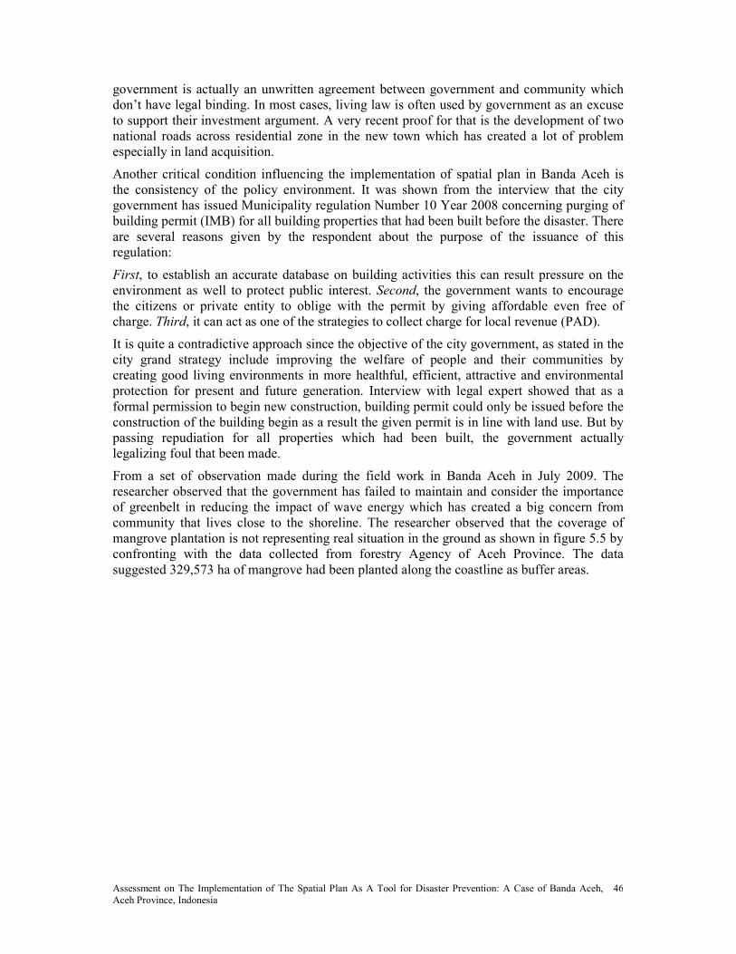
Assessment on The Implementation of The Spatial Plan As A Tool for Disaster Prevention: A Case of Banda Aceh, Aceh Province, Indonesia
46
government is actually an unwritten agreement between government and community which don’t have legal binding. In most cases, living law is often used by government as an excuse to support their investment argument. A very recent proof for that is the development of two national roads across residential zone in the new town which has created a lot of problem especially in land acquisition.
Another critical condition influencing the implementation of spatial plan in Banda Aceh is the consistency of the policy environment. It was shown from the interview that the city government has issued Municipality regulation Number 10 Year 2008 concerning purging of building permit (IMB) for all building properties that had been built before the disaster. There are several reasons given by the respondent about the purpose of the issuance of this regulation:
First, to establish an accurate database on building activities this can result pressure on the environment as well to protect public interest. Second, the government wants to encourage the citizens or private entity to oblige with the permit by giving affordable even free of charge. Third, it can act as one of the strategies to collect charge for local revenue (PAD).
It is quite a contradictive approach since the objective of the city government, as stated in the city grand strategy include improving the welfare of people and their communities by creating good living environments in more healthful, efficient, attractive and environmental protection for present and future generation. Interview with legal expert showed that as a formal permission to begin new construction, building permit could only be issued before the construction of the building begin as a result the given permit is in line with land use. But by passing repudiation for all properties which had been built, the government actually legalizing foul that been made.
From a set of observation made during the field work in Banda Aceh in July 2009. The researcher observed that the government has failed to maintain and consider the importance of greenbelt in reducing the impact of wave energy which has created a big concern from community that lives close to the shoreline. The researcher observed that the coverage of mangrove plantation is not representing real situation in the ground as shown in figure 5.5 by confronting with the data collected from forestry Agency of Aceh Province. The data suggested 329,573 ha of mangrove had been planted along the coastline as buffer areas.
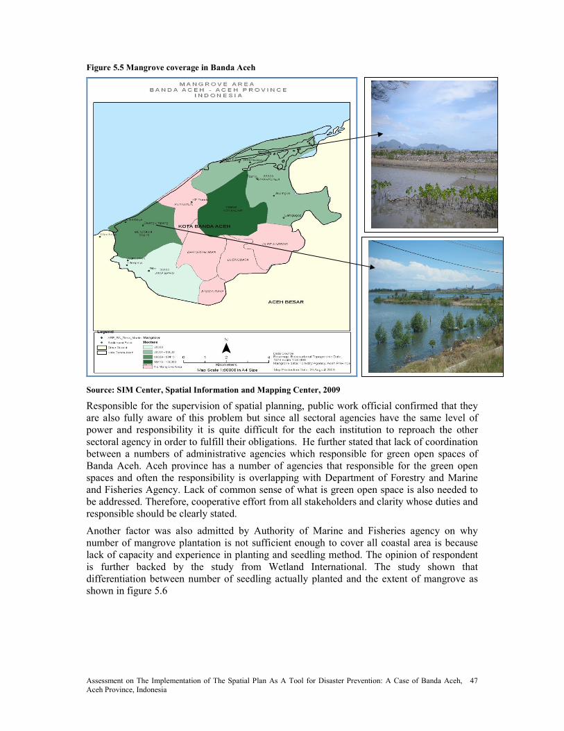
Assessment on The Implementation of The Spatial Plan As A Tool for Disaster Prevention: A Case of Banda Aceh, Aceh Province, Indonesia
47
Figure 5.5 Mangrove coverage in Banda Aceh
z
Source: SIM Center, Spatial Information and Mapping Center, 2009
Responsible for the supervision of spatial planning, public work official confirmed that they are also fully aware of this problem but since all sectoral agencies have the same level of power and responsibility it is quite difficult for the each institution to reproach the other sectoral agency in order to fulfill their obligations. He further stated that lack of coordination between a numbers of administrative agencies which responsible for green open spaces of Banda Aceh. Aceh province has a number of agencies that responsible for the green open spaces and often the responsibility is overlapping with Department of Forestry and Marine and Fisheries Agency. Lack of common sense of what is green open space is also needed to be addressed. Therefore, cooperative effort from all stakeholders and clarity whose duties and responsible should be clearly stated.
Another factor was also admitted by Authority of Marine and Fisheries agency on why number of mangrove plantation is not sufficient enough to cover all coastal area is because lack of capacity and experience in planting and seedling method. The opinion of respondent is further backed by the study from Wetland International. The study shown that differentiation between number of seedling actually planted and the extent of mangrove as shown in figure 5.6

Assessment on The Implementation of The Spatial Plan As A Tool for Disaster Prevention: A Case of Banda Aceh, Aceh Province, Indonesia
48
Figure 5.6 Comparison umber Seedling Planted And Extends Of Mangrove
Source: Wetland International, 2006
5.3 The effectiveness of the implementation of spatial plan
In order to assess the effectiveness of Banda Aceh spatial plan to minimize and mitigate effect of natural disaster, for the purpose of this analysis interview with an expert from Tsunami Disaster Mitigation Research Center (TDMRC) was conducted. The opinions of the expert are discussed below:
The expert revealed that the present spatial plan Banda Aceh is not yet addressing the threat of climate change. Although, the government already incorporating several mitigation measures in the spatial plan to minimize potential future disasters but the government is not yet fully aware of the threat of climate change to our living environment. According to the expert, most of mitigation measures that incorporated in the present spatial plan are still strongly emphasized on structural measures for example providing protective measures such as escape building and escape route in the case of tsunami or earthquake. It was understood from his explanation that the government both level regional and local is not yet incorporate mitigation measures that can adapt to the effect of climate change. He argued that one of example of unsustainable behavior that drives climate change is our dependency on fossil fuel. In line with the opinion of the expert, Baker (1997) who suggested promoting high densities as one of sustainability measure that can be applied in spatial planning.
However, contradictive to expert argument, 50% key respondents from local government argued that the present spatial plan is already effective in accommodating hydrological and geological hazards and topography in Banda Aceh while 30% of respondents represent did not know whether the present spatial already appropriate for Banda Aceh. The answers of respondents are shown in table 5.3;
Table 5.3 Respondents Who Agree Whether the Spatial Plan Is an Ideal Plan for Banda Aceh
Answer �umber of respondents Percentage (%)
Agree 5 50
Disagree 2 20
Do not know 3 30
Total 10 100
Source: Survey data, 2009

Assessment on The Implementation of The Spatial Plan As A Tool for Disaster Prevention: A Case of Banda Aceh, Aceh Province, Indonesia
49
In order to assess the effectiveness of spatial plan as a tool for disaster prevention, the researcher analyzed the quality of the plan based mitigation measures existed in literature review then confronted with mitigation measure identified by interviewee.
Table 5.4 Effective Criteria to Spatial Plan as a Tool for Disaster Prevention According To the Literature
and What Were Implemented
�o. Mitigation measures
(literature review)
Identified Mitigation measures
in RTRWK Banda Aceh
Result References
1 Open space controls Open space x Nadin, 2001; CDS, 998; Baker (1997)
2 Conservation area Greenbelt x UN, 1978
3 Zoning instruments Zoning regulation x UN, 1978
Restriction development zone x
4 Construction and location permits
Land use regulation x UN, 1978; ISDR, 2004
5 Building code Building regulation x Maryland Code, 2006
6 Encroachment line River and shore encroachment line
x UN, 1978
7 Sub division regulation - UN, 1978
8 Mixed use Mixed use - Nadin, 2001; CDS, 998; Baker (1997)
9 Public works and engineering Escape building x UN, 1978
Escape road
Ring road
10 Secondary center and new
town
New development zone x UN, 1978
Source: self modified
From table 5.4, it shows that from 8 out of 10 criteria mentioned in the literature is been fulfilled in the spatial plan. To summarize, the present spatial plan was conceived in a way that can be expected to be effective to minimize future disasters.
5.3 How can the spatial plan implementation be improved
The first strategy that should be done in order to improve the implementation of spatial plan is to have a final approved spatial plan with mended complaints, since it will be legally binding which was due in July 2009, and then they would prioritize its implementation in order to sort various developments. It is common thing in Aceh that development always ahead of regulation. This strategy was mainly pointed out by the respondents.
Regional Development Planning (BAPPEDA) officials explained that in order to improve the planning process needs adequate resources support such as staff, money, time, technical expertise and others. BAPPEDA as leading agency in the development of city has provided Geographical information system trainings for all physical planner of cross sectoral which is conducted every year as one of the strategies to improve capacity of the planners in supporting all aspects of planning management. Six GIS trainings were conducted where the participants were from several government agencies namely:- Regional Planning Agency, Regional office for environment, Public Works, National Land Agency, Marine and Fisheries Agency, Educational Agency, Transportation Agency, Forestry Agency, etc. In regard to

Assessment on The Implementation of The Spatial Plan As A Tool for Disaster Prevention: A Case of Banda Aceh, Aceh Province, Indonesia
50
environmental management, the BAPPEDA official explained that the city government planned to integrate environmental perspective in every building regulation as an instrument to implement spatial plan for in near future.
While the spatial planning department at Public Works revealed that “We need tougher enforcement”. He explained that for everyone that do not complying with spatial plan will be imposed with compensation and penalty, not only for the applicants but also for the authorities who issuing the permits. On the top of that, strong leadership and political will from the government are most likely support the implementation.
According to the legal expert, progressive law could be one of the approaches used by the government to improve the implementation of spatial plan. Progressive law could be municipality regulation passed by city government as legal basis to implement spatial plan prior the approval of new spatial plan.
Land National Agency official expressed that hopefully in the near future, BPN will be in formal team in the preparation process of the spatial plan. Not only providing data on present land use in plan development process. She further point out that the city of government should apply land consolidation project in the implementation of spatial plan. Also there is a need to develop a comprehensive legal regulation referring to land consolidation especially in within the context of land management of city and disaster management. The interviewee suggested that socialization on social acceptance of land consolidation need to be improved.
The expert from Tsunami and Mitigation Center suggested in adapting to climate change, the government start promoting the Acehnese cultural heritage “Rumoh Aceh” that can incorporated in the building standard especially to minimize the risk of coastal flooding for communities that lived near to the coast.
5.4 Community Perceptions toward the content and implementation of spatial plan
The analysis of public perception toward the content and implementation of spatial plan covered all three selected villages in Meuraxa sub district. Data about social economic of all respondents is shown in Annex 3.
From questionnaires of three selected communities in Meuraxa sub district shows that 77, 8% confessed that they did not aware of the existence of spatial plan since they have not received any information from the government about the socialization of the planning as shown in table 5.5.
Table 5.5 Community Awareness on the Existence of Spatial Plan
Answer of respondents �umber of respondents Percentage (%)
Yes 10 22.2
o 35 77.8
Total 45 100.0
Source: Questionnaire data
The communities pointed out that they also did not know much about the content of the spatial plan. Although, in general, 88, 9% of the community revealed that they are not aware of the existence of mitigation measure that had been incorporated in the spatial plan shown in annex 3. The communities noticed that green belt and coastal zone are the two mitigation measures proposed in their village as shown in the figure 5.7

Assessment on The Implementation of The Spatial Plan As A Tool for Disaster Prevention: A Case of Banda Aceh, Aceh Province, Indonesia
51
Figure 5.7 Mitigation Measures Proposed in Three Villages in Meuraxa ( =45)
Source: Data questionnaire
42,2% of the community stated that the information about mitigation measures that proposed in each village was obtained from the Nongovernmental Organization which actively involved in the rehabilitation of green belt in their villages while 22,2 % got the information from the media. However, the role of community leaders in disseminating the information is low (4, 4%) although they actively involved in planning process shown in table 5.6
Table 5.6 Obtained Information According To Community
Answers �umbers of answers Percentages
Government 14 31.1
Media 10 22.2
Community leader 2 4.4
NGO 19 42.2
Total 45 100.0
Source: Data questionnaire
In general, most all of communities in three villages agreed that the both coastal zone and eco zone can give positive benefit impact to each village. 37, 8% of communities in three villages expressed that the greenbelt which proposed in their villages can reduce the effect of coastal flooding but the community still do not believe that mangrove forest can reduce the impact of tsunami. 26, 7% of the communities believe that structural measures like sea wall could most likely work better than soft structural measure like greenbelt. However, only 8, 9% of respondents understand that greenbelt in their villages can also prevent coastal erosion as presented in table 5.7.
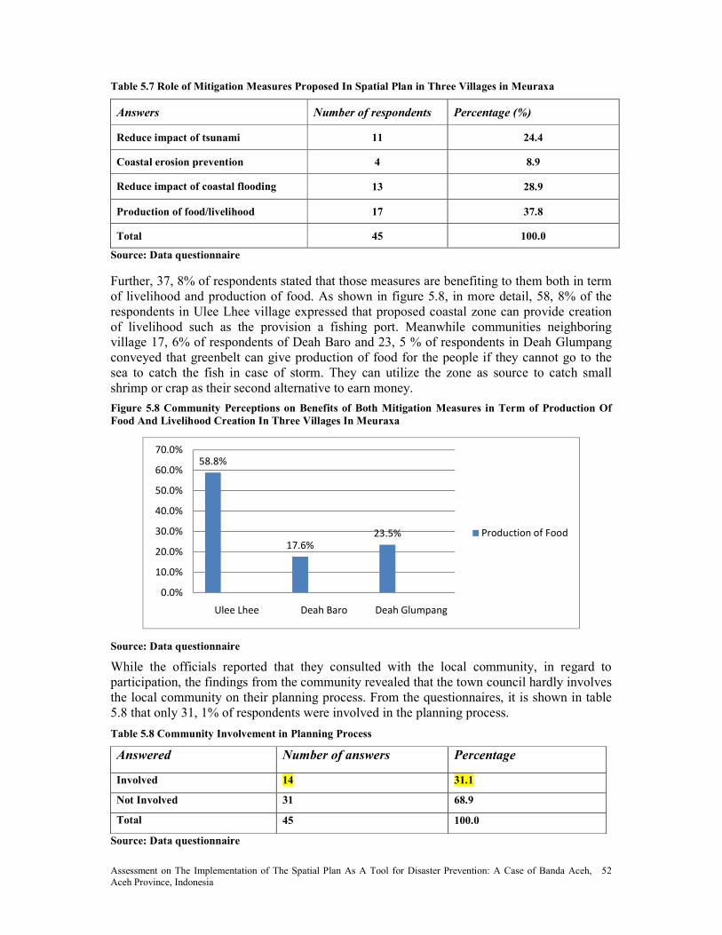
Assessment on The Implementation of The Spatial Plan As A Tool for Disaster Prevention: A Case of Banda Aceh, Aceh Province, Indonesia
52
Table 5.7 Role of Mitigation Measures Proposed In Spatial Plan in Three Villages in Meuraxa
Answers �umber of respondents Percentage (%)
Reduce impact of tsunami 11 24.4
Coastal erosion prevention 4 8.9
Reduce impact of coastal flooding 13 28.9
Production of food/livelihood 17 37.8
Total 45 100.0
Source: Data questionnaire
Further, 37, 8% of respondents stated that those measures are benefiting to them both in term of livelihood and production of food. As shown in figure 5.8, in more detail, 58, 8% of the respondents in Ulee Lhee village expressed that proposed coastal zone can provide creation of livelihood such as the provision a fishing port. Meanwhile communities neighboring village 17, 6% of respondents of Deah Baro and 23, 5 % of respondents in Deah Glumpang conveyed that greenbelt can give production of food for the people if they cannot go to the sea to catch the fish in case of storm. They can utilize the zone as source to catch small shrimp or crap as their second alternative to earn money.
Figure 5.8 Community Perceptions on Benefits of Both Mitigation Measures in Term of Production Of
Food And Livelihood Creation In Three Villages In Meuraxa
58.8%
17.6%
23.5%
0.0%
10.0%
20.0%
30.0%
40.0%
50.0%
60.0%
70.0%
Ulee Lhee Deah Baro Deah Glumpang
Production of Food
Source: Data questionnaire
While the officials reported that they consulted with the local community, in regard to participation, the findings from the community revealed that the town council hardly involves the local community on their planning process. From the questionnaires, it is shown in table 5.8 that only 31, 1% of respondents were involved in the planning process.
Table 5.8 Community Involvement in Planning Process
Answered �umber of answers Percentage
Involved 14 31.1
ot Involved 31 68.9
Total 45 100.0
Source: Data questionnaire
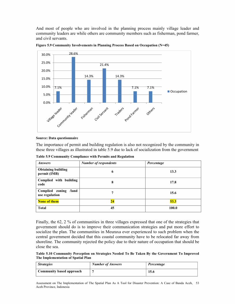
Assessment on The Implementation of The Spatial Plan As A Tool for Disaster Prevention: A Case of Banda Aceh, Aceh Province, Indonesia
53
And most of people who are involved in the planning process mainly village leader and community leaders are while others are community members such as fisherman, pond farmer, and civil servants.
Figure 5.9 Community Involvements in Planning Process Based on Occupation ( =45)
7.1%
28.6%
14.3%
21.4%
14.3%
7.1% 7.1%
0.0%
5.0%
10.0%
15.0%
20.0%
25.0%
30.0%
Occupation
Source: Data questionnaire
The importance of permit and building regulation is also not recognized by the community in these three villages as illustrated in table 5.9 due to lack of socialization from the government
Table 5.9 Community Compliance with Permits and Regulation
Answers �umber of respondents Percentage
Obtaining building
permit (IMB) 6 13.3
Complied with building
code 8 17.8
Complied zoning /land
use regulation 7 15.6
one of them 24 53.3
Total 45 100.0
Finally, the 62, 2 % of communities in three villages expressed that one of the strategies that government should do is to improve their communication strategies and put more effort to socialize the plan. The communities in Meuraxa ever experienced to such problem when the central government decided that this coastal community have to be relocated far away from shoreline. The community rejected the policy due to their nature of occupation that should be close the sea.
Table 5.10 Community Perception on Strategies eeded To Be Taken By the Government To Improved
The Implementation of Spatial Plan
Strategies �umber of Answers Percentage
Community based approach 7 15.6

Assessment on The Implementation of The Spatial Plan As A Tool for Disaster Prevention: A Case of Banda Aceh, Aceh Province, Indonesia
54
Socialization and
communication 28 62.2
Community participation 10 22.2
Total 45 100.0
Source: Data questionnaire
Another strategy mentioned by the community to improve the implementation of spatial plan is to promote public participation in the planning process. Therefore, bottom up approach in decision making process is most likely will minimize the failure of the implementation of planning product.

Assessment on The Implementation of The Spatial Plan As A Tool for Disaster Prevention: A Case of Banda Aceh, Aceh Province, Indonesia
55
Chapter 6: Conclusions and Recommendations
6.1 Conclusions
This chapter attempts to answer the research objective of this study - to assess the effectiveness of the implementation of present spatial plan in minimizing the impact of future natural disasters in Banda Aceh municipality. Based on the results and discussions presented in the chapter 5, we can draw the following conclusions:
On the basis of both analysis and the opinion of key persons, it can be concluded that mitigation aspect has been mainstreamed in the implementation of spatial plan in Banda Aceh. The government has successfully developed some structural and non-structural measures to support disaster management process of the city. The structural measures are the escape building, the escape road and the greenbelt; while the non-structural measures are the zoning instruments such as development of restricted and new development zones for the city. All these important initiatives are taken to minimize the loss and impact of future disasters.
The government has understood that a balance between structural and non structural measures to manage the natural disasters is required. Table 5.4 shows the Banda Aceh has adopted eight of the proposed international criteria in the design of its spatial plan. If this adoption is also being properly implemented, this plan will be able to effectively minimize the impact of future disasters.
Several infrastructures had been implemented by the government to support the disaster management in the city although not all activities had been successfully completed due to some constrains from lack of support from stakeholders to limited financial resources
The research finds that while waiting for the new spatial plan to be approved; The government has taken a too-quick decision to apply a living law as a legal basis in issuing the building permit rather than a temporary legal basis. As a result, this decision created a numerous spatial plan’s misconducts on the ground, not the investment argument or community wishes which often used by the government as excuses. The findings also show that a government’s policy to legalize all pre-disaster building properties is another evidence of the government’s inconsistency in implementing the spatial plan policy to achieve a safer city.
Finally, the absence of government’s socialization and community participation during the planning process of the spatial plan have resulted a serious awareness problem. The communities in the three selected villages of Meuraxa sub-district are simply not aware of the existence of spatial plan, which is also the reason of why they are not compliance with any of the permits and regulations.
Based on the research findings above, the researcher wish to conclude that the proposed research hypothesis: “The implementation of present spatial plan can effectively prevent the
future impact of natural disasters in Banda Aceh” is partially accepted.
6.2 Recommendations
There are few recommendations that I would like to convey to the government based on the research that I have completed:
Indonesia and Aceh in particular are located in ring of fire. Given the disaster risks faced by the region, these risks should be seriously recognized and treated as a real risk to the

Assessment on The Implementation of The Spatial Plan As A Tool for Disaster Prevention: A Case of Banda Aceh, Aceh Province, Indonesia
56
population and to the economy. If the government fails to address these risks with appropriate disaster mitigation measures, future development will also be put at risk. The government should take this spatial plan as a serious matter as careless planning can pose more dangers to the communities.
The fact that new spatial plan prepared by BRR consultant was copied paste from old one there is a need for the government to enhance the capacity of the local planner by conducting a training need assessment to minimize the level of fault in the spatial plan.
The fact that the government decided to use living law is unacceptable. This shows the lack of seriousness from the government. Therefore, it is recommended for government to establish progressive law as a legal basis to control the land use to achieve better organized, equitable, safe and environmental city.
Awareness training activities on building code must be conducted to encourage people to pay attention to reinforce their houses particularly in the restriction development zone.
Engage as much as possible members of local community to involve in the mangrove plantation since they know better how to plan and understand the benefits of mangrove to their safety and livelihood.

Assessment on The Implementation of The Spatial Plan As A Tool for Disaster Prevention: A Case of Banda Aceh, Aceh Province, Indonesia
57
Reference
Asian Coalition for Housing Rights, 2005, ‘Housing by People’, /ewsletter of the Asian
Coalition for Housing Rights /o.16, p.6
Adam et al, 2006, Regional development and spatial planning in an enlarged European Union, London
Act 27/2007, Undang – Undang Republik Indonesia, Nomor 26 Tahun 2007, Penataan Ruang, Departemen Pekerjaan Umum, Direktorat Jenderal Penataan Ruang.
Burby, R.J. (editor), 1998, Cooperating with nature: Confronting natural hazards with land-
use planning for sustainable communities. Washington, 376p
BPS NAD, 2006, Aceh Dalam Angka, BPS.
Bappenas, 2005, Indonesia: Preliminary Damage and Loss Assessment The December 26,
2004 /atural Disaster. Jakarta. World Bank
BRR, 2005, Land Issues in the ASEP Project, Aceh Special Region Indonesia, available http://know.brr.go.id/dc/articles/20050918_Land_Issues_Aesp_Project_Aceh_Special_Region_Indonesia.pdf
Baker, S., Kousis M., Richardson, D and Young, S., 1997, The politics of Sustainable
Development: Theory and policy and practice within the European Union, London, Routledge
Bruneau, M., S.E. Chang, R.T. Eguchi, G.C. Lee, T.D. O’Rourke, A.M. Reinhorn, M. Shinozuka, K.J. Tierney, W.A. Wallace, and D. von Winterfeldt, 2003. A framework
to quantitatively assess and enhance the seismic resilience of communities. Earthquake Spectra 19(4):733-752.
Berman, Paul. 1980. “Thingking About Programmed and Adaptive Implementation:
Matching Strategies to Situations, “pp.205-227 in Why Policies Succeed or Fail, ed. H.M. Ingram and D.E. Mann. Beverly Hills, Calif.: Sage Publications
Bardach, Eugene. 1977. The Implementation Game: What Happens After a Bill Becomes a
Law. Cambridge, Mass.: MIT Press
Barrett, Susan, and Fudge, Colin, eds. 1981. Policy and Action: Essays on The
Implementation of Public Policy. New York: Methuen.
Committee on Disaster Research in the Social Sciences: Future Challenges and Opportunities, National Research Council, 2006, Facing Hazards and Disasters: Understanding Human Dimensions
Committee for Spatial Development in The Baltic Sea Region (CSD/BSR), 1998, Spatial Planning for Sustainable Development in The Baltic Sea Region: Baltic 21 Series No 9/98, A VASAB 21010 Contribution to Baltic 21
Chang, S.E., and M. Shinozuka, 2004, Measuring improvements in the disaster resilience of communities. Earthquake Spectra 20(3):739-755.
Dahuri, R. 2007, ‘Pre-and post tsunami coastal planning and land use policies and issues in Indonesia’: proceedings of workshops on coastal area planning and management held in Bangkok, Thailand, 27 -29 September 2006, Food and Agriculture Organization, Bangkok, pp.111-129.

Assessment on The Implementation of The Spatial Plan As A Tool for Disaster Prevention: A Case of Banda Aceh, Aceh Province, Indonesia
58
Dardak, A. Hermanto, 2006, Perencanaan Tata Ruang Bervisi Lingkungan Sebagai Upaya Mewujudkan Ruang yang Nyaman, Produktif, dan Berkelanjutan, Lokakarya Revitalisasi Tata Ruang Dalam Rangka Pengendalian Bencana Longsor Dan Banjir Yogyakarta, 28 Februari 2006
Emergency Disasters Database (Em-Dat), 2009, Trends and Relationships for the period 1900-2005. Available at: http://www.em-dat.net/disasters/trends.htm, visited 02.04.2009
Enemark, Stig, 2004, Building Land Information Policies. Proceedings of Special Forum on Building Land Information Policies in the Americas. Aguascalientes, Mexico, October 26-27, 2004.
Enemark, Stig, 2005, Land Management and Development. CLGE International Conference 2005, Brussels/Belgium, 1-2 December 2005.
Faludi, A. & Waterhout, B.,2002 The Making of the European Spatial Development Perspective: No Master plan (London: Routledge).
Faludi, 2008, European Spatial Research and Planning, Lincoln Institute of Land Policy, Cambridge, Massachusetts
Fleischhauer, M., 2006, Spatial relevance of natural and technological hazards. In: Schmidt-Thomé (ed.) 2006. Natural and Technological Hazards and Risks in European Regions, Geological Survey of Finland, Special Paper 42, Espoo, 7-15.
Friesecke, Frank, 2005, Flood Risk Management – Flood Prevention by Land Consolidation in the Rhine Catchment Area, FIG Working Week 2005 and GSDI-8 Cairo, Egypt, April 16-21, 2005.
Fleischhauer, M., S. Greiving, and S. Wanczura, eds, 2006, Natural hazards and Spatial Planning in Europe. Dortmund : Dortmunder Vertrieb fur Bau – und Planungsliteratur.
FIG, 2006, The Contribution of the Surveying Profession to Disaster Risk Management, A publication of FIG Working Group 8.4 International Federation of Surveyors (FIG), Copenhagen, Denmark
Godschalk, D. R., Beatley, T., Berke, P., Brower, D. J., Kaiser, E. J., Bohl, C. C. & Goebel, R. M, 1999, Natural hazard mitigation – recasting disaster policy and planning. Washington, 575p.
Halley, P, 1997, Collaborative Planning: Shaping places in fragmented societies, London.
Holling, C.S, 1973, Resilience and stability of ecological systems. Annual Review of Ecology and Systematics 4:1-23.
Hill, M., and P. Hupe. 2002. Implementing Public Policy: Governance in Theory and Practice, London
Hill, Michael. 1997. The Policy Process in Modern State. 3rd ed. Toronto: Prentice Hall
Hood, Christoper. 1976. The Limits of Administration. New York: Wiley
Marbun, B.N, 1990, Kota Indonesia Masa Depan, Erlangga Publisher, Jakarta
Mazmanian, D.A., and P.A. Sabatier. 1989. Implementation and Public Policy. Lanham,
MD: University Press of America

Assessment on The Implementation of The Spatial Plan As A Tool for Disaster Prevention: A Case of Banda Aceh, Aceh Province, Indonesia
59
McLaughlin, Milbrey. 1975. “Implementation as Mutual Adaptation. “pp.167-180. In ed. Walter Williams and Richard Elmore. Social Program Implementation. New York: Academia Press.
Margerum, R.D. 1999a. Implementing Integrated Planning and Management. Australian Planner 36(3): 155-161.
Nakamura, RT., and F. Smallwood. 1980. The Politics of Policy Implementation. New York: St. Martin’s Press.
International Strategy for Disaster Reduction (ISDR), 2004, Living with Risk: A Global
Review of Disaster Reduction Initiatives. Volumes I and II. Geneva: United Nations Press.
International Strategy for Disaster Reduction (ISDR), 2004. Resolution adopted by the
General Assembly 58/214 on the report of the Second Committee (A/58/484/Add.5). 4p
Idjaz, A, 2009, Kedudukan Evaluasi dalam Rencana Tata Ruang, Serial Pembangunan Daerah, SPD 20 Teknik Evaluasi Tata Ruang, accessed 15 May 2009, http://www.geocities.com/ahmad_idjaz/spd20evaluasi.html
Jock R. Anderson, 2003, Risk in rural development: challenges for managers and policy
makers, Rural Development Department, World Bank, 1818 H St NW, Washington, DC 20433-0001, USA Volume 75, Issues 2-3, Pages 161-197
Japan International cooperation Agency, 2005, The study on the urgent rehabilitation and
reconstruction support program for Aceh province and affected areas in /orth
Sumatra, Final Report (1)
Kriswati, E., 2008, The Role of the Quick Response Team During Volcanic Crises in
Indonesia, in Total Disaster Risk Management: Good Practices 2008, Asian Disaster Reduction Conter March 2008.
Kotter, T, 2003, Prevention of Environmental Disaster by Spatial Planning and Land
Management, 2nd FIG Regional Conference, Marrakech, Morroco. L
Kotter T, 2004, Risk Management, Report for the 27th General Assembly FIG Working Week in Athens, 23-27 May 2004: FIG Commission 8 – Spatial Planning and Development Report on Activities 2003–2004. Available at http://www.fig.net/admin/ga/2004/app_9_comm_8.pdf
Kotler, P., Adam, S., Brown, L., & Armstrong, G., 2006,. Principles of Marketing. Prentice
Hall.
Koresawa, A and Konvitz, J, 2001, Toward a /ew Role for Spatial Planning in: Neil Adams, Jeremy Alden, Neil Harris, 2006, Regional Development and Spatial Planning in Enlarge European Union
Larsson, G, 2006, Spatial Planning Systems in Western Europe: An Overview, Royal Institute of Technology, Stockholm, Sweden, IOS Press, Amsterdam
Munich Re., 2002, Topics: Annual Review, /atural Catastrophes. Available at www. munichre.com/default_e.asp (Accessed September 6, 2004).
Marttila, V., Granholm, H., Laanikari, J., Yrjola, T., Aalto, A., Heikinheimo, P., Honkatuki, J., Järvinen, H., Liski, J., Merivirta, R. & Paunio, M. (eds). 2005. Finland's /ational
Assessment on The Implementation of The Spatial Plan As A Tool for Disaster Prevention: A Case of Banda Aceh, Aceh Province, Indonesia
60
Strategy for Adaptation to Climate Change. Ministry of Agriculture and Forestry, Helsinki p 280.
MOLG, 2003c, Urban Planning and Management in Local Government, 68
Magel, Holger; Wehrmann, Babette, 2001: Applying Good Governance to Urban Land
Management – Why and How? Zeitschrift für Vermessungswesen (ZfV), 6/2001, p.310-316
Munich Reinsurance Company, 2004. Great /atural Catastrophes, Topics geo 1/2004:
Annual Review of Natural Catastrophes 2003. Munich. 60p
Mileti, D.S, 1999b. Disasters by Design: A Reassessment of /atural Hazards in the United
States. Washington, DC: Joseph Henry Press.
Murdiono L. W., 1993, Environmental Planning in Indonesia: The Linkage between Spatial
Plan and Environmental Impact Assessment, Bandung Institute of Technology. Submitted to the Department of Urban Studies and Planning in Partial Fulfillment of the Requirements for the Degree of Master in City Planning at the Massachusetts Institute of Technology, June 1998
Nadin, V., 2001, Sustainability from National spatial planning perspectives in : Towards a new role of spatial planning, Organization for Economic Co-operation and Development.
Official Development Assistance Indonesia website, http://www.id.emb-japan.go.jp/oda/en/whatisoda_04g.htm, 2009
Polit, D. F & Hungler, B. P, 1999 – /ursing Research – Principles & Methods (6th Ed), J. B. Philadelphia, Lippincott Company p.284
Quarantelli, E.L. 1995. Disaster planning, emergency management and civil protection: the
historical development of organized efforts to plan for and to respond to disasters. Preliminary Paper #227. Newark, DE. Disaster Research Center, University of Delaware. 36p. Available at: http://www.udel.edu/DRC/preliminary/227.pdf, visited 02.08.2006
Reade, E., 1983. Monitoring in Planning Evaluating Urban Planning Efforts. Gower Publishing Co. Ltd, Hamshire.
Rothsein, Bo.1998. Just Institutions Matters: The Moral and Political Logic of the Universal Welfare State. New York: Cambridge University Press
Rein, Martin, and Francine F. Rabinovitz. 1978. “Implementation: A Theoretical Perspective, “pp.307 -335. In American Politics and Public Policy, ed. W.D Burnham and M.W Weinberg. Cambridge, Mass.: MIT Press.
Schmidt – Thome, P., J. Jarva, S. Haanpaa, S. Lehtonen and Peltonen., 2006, A country
without hazards? In Positioning Finland in a European Space, H. Eskelinen and T. Hirvonen, eds, 121-135. Helsinki: Ministry of the Environment, Ministry of the Interior.
Schmidt – Thome, P, 2006a, Integration of natural hazards, risk and climate change into
spatial planning practices. Academic dissertation no.193 of the University of Helsinki. Geological Survey of Finland.

Assessment on The Implementation of The Spatial Plan As A Tool for Disaster Prevention: A Case of Banda Aceh, Aceh Province, Indonesia
61
Suresh, M.R., Manjunath, K.V., and Hegde, M.N., 2005, Earthquake hazards, preparedness,
mitigation and management issues. Proceedings of the National Conference on Geotechnics in Environmental Protection, 9-10 April: X5-X8.
Schutt, R. K.,2006,. Investigating the Social World: The Process and Practice of Research.
Nettville: Pine Forge Press.
Sitarz, D. (ed.) 1993. Agenda 21: The Earth Summit Strategy to Save Our Planet. Covel, CA: Island Press.
Tempo Interaktif, 17 April 2008, Banjir Malang Akibat Pelanggaran Tata Ruang, available http://www.tempointeraktif.com/hg/nusa/2008/04/17/brk,20080417-121488,id.html
Talen, E., 1997. Success, failure and conformance: an alternative approach to planning
evaluation. Environment and Planning B: Planning and Design 24, 573–587.
Taleai, M., Mansourian, A., 2008, Using Delphi –AHP method to survey major factors
causing urban plan implementation failure, Journal applied sciences vol.8, issue: 15, page no. 2746 – 2751.
Tewdwr-Jones, 2004, Spatial Planning: Principles, practice and culture. Journal of planning and environment law 57 (5)
United Nations, 1978, Disaster Prevention and Mitigation: A Compendium of Current Knowledge, Vol. 4. Meteorological Aspects, New York
United Nations Development Programme, Bureau for Crisis Prevention and Recovery (UNDP/BCPR) (2004): Reducing Disaster Risk. A Challenge for Development. A global report, New York 2004.
UNEP, 2006, Environmental Emergency Response to the South Asia Earthquake: Consolidated report on activities undertaken through the Joint UNEP/OCHA Environment Unit
United Nations, 2004. International Strategy for Disaster Reduction. Resolution adopted by
the General Assembly 58/214 on the report of the Second Committee (A/58/484/Add.5). 4p
United Nations and Economic Commission for Europe (UN/ECE), 2000,: Guidelines on
Sustainable Flood Protection. Available http://www.unisdr.org/eng/library/isdr-publication/flood-guidelines/Guidelines-for-reducing-floods-losses.pd
United Nations ESCAP, 1999, Water Hazards, Resources and Management for Disaster
Prevention: A Review of the Asian Conditions ID/DR 1991-1999, IDNDR
United Nations Development Programme, Banda Aceh: From Debris and Rubble to Environmental Award, Press Release UNDP 10 June 2009.
Vale, L., and T.J. Campanella (eds.) 2005. A Resilient City. London: Oxford University Press.
Waterhout, B., 2001, Polycentric Development: What’s Behind it? Paper for the Lincoln Institute Conference on European Spatial Planning (Cambridge MA: Lincoln Institute).
Williams, R. H., 1996b, /etworks and /etworks in European Space, Paper for the 50th
Anniversary Conference, Shaping Places: Conceptions and Directions for Spatial
Planning (Newcastle: Department of Town and Country Planning, University of Newcastle).

Assessment on The Implementation of The Spatial Plan As A Tool for Disaster Prevention: A Case of Banda Aceh, Aceh Province, Indonesia
62
World Bank, Aceh Economic Update May 2009 Newsletter, Available at http://www-wds.worldbank.org/external/default/WDSContentServer/WDSP/IB/2009/07/01/000333038_20090701013738/Rendered/PDF/491870NEWS0P111june091english1final.pdf
Zhang, Zhongxiang, 2005, Towards an effective implementation of clean development
mechanism projects in China.

Assessment on The Implementation of The Spatial Plan As A Tool for Disaster Prevention: A Case of Banda Aceh, Aceh Province, Indonesia
63
Annex 1: List of Interview Questions
Institute for Housing and Urban Development Studies (IHS) Erasmus University Rotterdam (EUR)
The Netherlands
This list of interview questions is a research instrument of the master’s programme thesis on
the role of spatial planning in disaster mitigation, a case of Banda Aceh Municipality, /AD
All information from the interviewees will be used only for academic purposes
I. Interviewee’s Profiles
1. Name of interviewee : …………….…………………………………….……….. .
2. Name of organization : ……………………………………………………………..
3. Type of the organization : ………………………………………………..…………….
4. Position in the organization: ……………………….……………………..…..…………..
5. Office address : …………………………………………………….…….….
6. Time of interview : ………………………………………………………………
II. Questions
1. Do you participate in the plan making process?
2. What role did you play in plan preparation?
3. According to Act 24/07 about the spatial planning, all spatial plans in each government level should incorporating mitigation measure. In your opinion, does the present spatial plan have integrating mitigation measures in order to minimizing impact of future disaster? If yes…please explain ………
4. How do you see the role of present spatial plan in minimizing the impact of future disasters?
5. In your opinion, what is the ideal spatial plan that can be adopted by local governments with respect to topography, the region and type of disaster in Banda Aceh?
6. What is the role of your organization in the implementation of the present spatial plan?
7. What is your opinion about the implementation of the present spatial plan?
8. What kinds of program does your institution have to support the implementation of disaster mitigation? 9. In how far is the implementation of this program? 10. What are the outputs achieved so far?
11. How much allocated budget available in order to implement it? If it sufficient?
12. Internally, what are the challenges or constrain do you experience to implement this program (e.g. coordination, institutional capacity)?
13. Externally, what are the challenges do you encounter in order to implement this program in Meuraxa sub district?

Assessment on The Implementation of The Spatial Plan As A Tool for Disaster Prevention: A Case of Banda Aceh, Aceh Province, Indonesia
64
14. What kind of efforts already undertaken by your organization in order to cope with these problems internally and externally?
15. Are there any policies/measures taken by the government to improve the enforcement implementation? 16. How could the implementation of the present spatial plan be improved in order to minimize the impact of future disaster?
Thank you

Assessment on The Implementation of The Spatial Plan As A Tool for Disaster Prevention: A Case of Banda Aceh, Aceh Province, Indonesia
65
Annex 2: Survey Questionnaires
Public perception in Meuraxa sub districts: Content and Implementation of spatial plan Institute for Housing and Urban Development Studies (IHS)
Erasmus University Rotterdam (EUR) The Netherlands
SECTIO 1 SOCIAL A D ECO OMIC DATA
1. Sex of respondent.
a. Male b. Female
2. Age of respondent.
a. 15-23 d. 41- 65
b. 24-30 e. 66-70
c. 31-40 f. 71+
3. Occupation of respondent………………………………………….
4. What is the highest level of education you have completed? a. Primary d. Graduate
b. junior high school e. Others
c. Senior high school
5 Area of Residence……..
a. Deah Baro village
b. Ulee Lhee
c. Deah Glumpang
6. How long have you lived at this address? ________________________________ 7. How far from the sea do you live?
a. 0-2 km b. 2-5 km c. 5-10 km d. 10+ km
8. Are you aware with the existence of the present spatial plan? (Yes / No ) 9. Are you aware that that government has incorporating mitigation measures in the present
spatial plan? (Yes / No )? 10. Do you know which following mitigation measures proposed in the spatial plan in your
village? a. Coastal zone b. Eco zone c. Traditional city center zone d. Urban development zone e. Other……………………………………………….
11. How do you find the information? a. Direct socialization of government b. Media, c. from the community leader d. Others ……………….

Assessment on The Implementation of The Spatial Plan As A Tool for Disaster Prevention: A Case of Banda Aceh, Aceh Province, Indonesia
66
12. In your opinion, do you think that the mitigation measures proposed in the present spatial plan can give benefit effect to your village?
13. If yes, in what way has the spatial plan made to your village? a. to reduce the devastating impact of a tsunami and storm surge by decreasing
their wave energies
b. coastal erosion prevention,
c. protection of coral reefs from siltation,
d. pollutant control,
e. production of food, timber and traditional medicines,
f. an assortment of flora and fauna
14. Does the government involve community participation in implementing their plan? 15. Do you participate in the plan implementation? If yes, 16. In what extent, do you participating?
a. Obtaining building permit (IMB) b. Complied with building code c. Complied land use regulation
17. Are there any problems that do you face as a result of the implementation of the present spatial plan?
a. Relocation b. Land acquisitions c. Rigidity
18. If you pick one of the options to question above, in your opinion, what are the impacts felt to you? Please explain………………………………………………………………………………
19. In your opinion, what strategies should be undertaken by the government in order to improve the quality performance of the implementation spatial plan?
a. Community based approach b. Socialization and communication strategies c. Community participation
20. Are there any comments and suggestions that you would like to make?...........................
Thank you
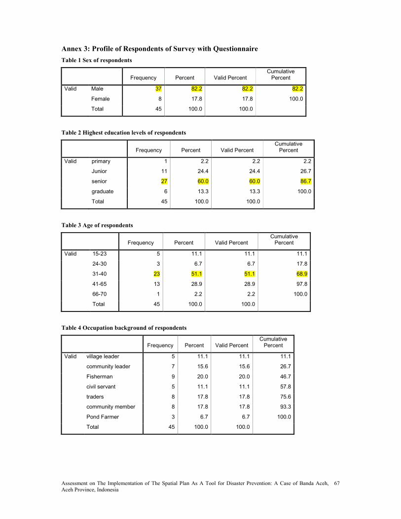
Assessment on The Implementation of The Spatial Plan As A Tool for Disaster Prevention: A Case of Banda Aceh, Aceh Province, Indonesia
67
Annex 3: Profile of Respondents of Survey with Questionnaire
Table 1 Sex of respondents
Frequency Percent Valid Percent Cumulative Percent
Valid Male 37 82.2 82.2 82.2
Female 8 17.8 17.8 100.0
Total 45 100.0 100.0
Table 2 Highest education levels of respondents
Frequency Percent Valid Percent Cumulative Percent
Valid primary 1 2.2 2.2 2.2
Junior 11 24.4 24.4 26.7
senior 27 60.0 60.0 86.7
graduate 6 13.3 13.3 100.0
Total 45 100.0 100.0
Table 3 Age of respondents
Frequency Percent Valid Percent Cumulative Percent
Valid 15-23 5 11.1 11.1 11.1
24-30 3 6.7 6.7 17.8
31-40 23 51.1 51.1 68.9
41-65 13 28.9 28.9 97.8
66-70 1 2.2 2.2 100.0
Total 45 100.0 100.0
Table 4 Occupation background of respondents
Frequency Percent Valid Percent Cumulative Percent
Valid village leader 5 11.1 11.1 11.1
community leader 7 15.6 15.6 26.7
Fisherman 9 20.0 20.0 46.7
civil servant 5 11.1 11.1 57.8
traders 8 17.8 17.8 75.6
community member 8 17.8 17.8 93.3
Pond Farmer 3 6.7 6.7 100.0
Total 45 100.0 100.0

Assessment on The Implementation of The Spatial Plan As A Tool for Disaster Prevention: A Case of Banda Aceh, Aceh Province, Indonesia
68
Table 5 Community Awareness of the existence of mitigation measures in the spatial plan
Answer of respondents �umber of respondents Percentage (%)
Yes 5 11.1
o 40 88.9
Total 45 100.0

Assessment on The Implementation of The Spatial Plan As A Tool for Disaster Prevention: A Case of Banda Aceh, Aceh Province, Indonesia
69
Annex 4 Land Use Plan