Tsunami hazard in the Black Sea and the Azov Sea: a new ... · Tsunami hazard in the Black Sea and...
19
Nat. Hazards Earth Syst. Sci., 11, 945–963, 2011 www.nat-hazards-earth-syst-sci.net/11/945/2011/ doi:10.5194/nhess-11-945-2011 © Author(s) 2011. CC Attribution 3.0 License. Natural Hazards and Earth System Sciences Tsunami hazard in the Black Sea and the Azov Sea: a new tsunami catalogue G. A. Papadopoulos 1 , G. Diakogianni 1 , A. Fokaefs 1 , and B. Ranguelov 2 1 Institute of Geodynamics, National Observatory of Athens, 11810 Athens, Greece 2 Geophysical Institute, Bulgarian Academy of Sciences, Sofia, Bulgaria Received: 1 September 2010 – Revised: 1 December 2010 – Accepted: 1 December 2010 – Published: 25 March 2011 Abstract. Data on tsunamis occurring in the Black Sea and the Azov Sea from antiquity up to the present were updated, critically evaluated and compiled in the standard format developed since the 90’s for the New European Tsunami Catalogue. Twenty nine events were examined but three of them, supposedly occurring in 557 AD, 815 AD and 1341 or 1343, were very likely falsely reported. Most of the remaining 26 events were generated in Crimea, offshore Bulgaria as well as offshore North Anatolia. For each of the 26 events examined, 22 events were classified as reliable ones receiving a score of 3 or 4 on a 4-grade reliability scale. Most of them were caused by earthquakes, such as the key event 544/545 of offshore Varna, but a few others were attributed either to aseismic earth slumps or to unknown causes. The tsunami intensity was estimated using the traditional 6-grade scale and the new 12-grade scale introduced by Papadopoulos and Imamura (2001). From 544/545 up to now, only two reliable events of high intensity K ≥ 7 have been reported, which very roughly indicates that the mean repeat time is ∼ 750 years. Five reliable tsunamis of moderate intensity 4 ≤ K< 7 have been observed from 1650 up to the present, which implies a recurrence of 72 years on the average. Although these calculations were based on a very small statistical sample of tsunami events, the repeat times found are consistent with the theoretical expectations from size-frequency relations. However, in the Black Sea there is no evidence of tsunamis of very high intensity (K ∼ 10) such as the AD 365, 1303 and 1956 ones associated with large earthquakes occurring along the Hellenic arc and trench, Greece, or the 1908 one in Messina strait, Italy. This observation, along with the relatively low tsunami frequency, indicates that the tsunami hazard in the Black Sea is low to moderate but not negligible. The tsunami hazard in the Azov Sea is very low because of the very low Correspondence to: G. A. Papadopoulos ([email protected]) seismicity but also because of the shallow water prevailing there. In fact, only three possible tsunami events have been reported in the Azov Sea. 1 Introduction The study of tsunami phenomena in the Black Sea region, including the Azov Sea, has been the subject of several papers. The first studies focused on the collection and analysis of mareograms of instrumentally recorded tsunami events, such as those of 1927, 1939 and 1966 generated by strong earthquakes (Dvoichenko, 1927, 1928; Markevich, 1928; Grigorash, 1959a, b; Grigorash and Korneva, 1969, 1972a). At a later stage, the studies were expanded to topics like the energy and spectra of tsunami waves (Grigorash and Korneva, 1970, 1972b; Korneva and Grigorash, 1979; Rangelov et al., 1987; Spassov and Rangelov, 1987), numerical hydrodynamic models (Engel, 1974; Choi et al., 1993; Dotsenko, 1993; Dotsenko and Konovalov, 1996; Yalciner et al., 2004), selection of the zones of tsunami generation (Christokov and Typkova- Zaimova, 1979; Ranguelov et al., 1983; Kuran and Yalc ¸iner, 1993; Selezov and Ostroverkh, 1997; Solov’eva et al., 2004; Solov’eva and Kuzin, 2005; Dotsenko and Eremeev, 2008) and tsunami height-earthquake magnitude relations (Pelinovsky, 1999) including some tsunami vulnerability and hazard estimates (Oaie et al., 2006a) and an attempt to calculate the repeat times of tsunami wave heights (Litvinenko and Strekalov, 2001). Schuiling et al. (2007) considered the case of the impact of a small asteroid that would hit the Black Sea region and showed that the potential emissions of toxic and flammable gases could be more disastrous to the region than the tsunami caused by the impact. On the other hand, Dotsenko and Eremeev (2008) dicussed the necessity and possibility of tsunami early warning in the Black Sea. Published by Copernicus Publications on behalf of the European Geosciences Union.
Transcript of Tsunami hazard in the Black Sea and the Azov Sea: a new ... · Tsunami hazard in the Black Sea and...

Nat. Hazards Earth Syst. Sci., 11, 945–963, 2011www.nat-hazards-earth-syst-sci.net/11/945/2011/doi:10.5194/nhess-11-945-2011© Author(s) 2011. CC Attribution 3.0 License.
Natural Hazardsand Earth
System Sciences
Tsunami hazard in the Black Sea and the Azov Sea:a new tsunami catalogue
G. A. Papadopoulos1, G. Diakogianni1, A. Fokaefs1, and B. Ranguelov2
1Institute of Geodynamics, National Observatory of Athens, 11810 Athens, Greece2Geophysical Institute, Bulgarian Academy of Sciences, Sofia, Bulgaria
Received: 1 September 2010 – Revised: 1 December 2010 – Accepted: 1 December 2010 – Published: 25 March 2011
Abstract. Data on tsunamis occurring in the Black Seaand the Azov Sea from antiquity up to the present wereupdated, critically evaluated and compiled in the standardformat developed since the 90’s for the New EuropeanTsunami Catalogue. Twenty nine events were examined butthree of them, supposedly occurring in 557 AD, 815 AD and1341 or 1343, were very likely falsely reported. Most ofthe remaining 26 events were generated in Crimea, offshoreBulgaria as well as offshore North Anatolia. For each ofthe 26 events examined, 22 events were classified as reliableones receiving a score of 3 or 4 on a 4-grade reliabilityscale. Most of them were caused by earthquakes, suchas the key event 544/545 of offshore Varna, but a fewothers were attributed either to aseismic earth slumps orto unknown causes. The tsunami intensity was estimatedusing the traditional 6-grade scale and the new 12-grade scaleintroduced by Papadopoulos and Imamura (2001). From544/545 up to now, only two reliable events of high intensityK ≥ 7 have been reported, which very roughly indicates thatthe mean repeat time is∼ 750 years. Five reliable tsunamisof moderate intensity 4≤ K < 7 have been observed from1650 up to the present, which implies a recurrence of72 years on the average. Although these calculations werebased on a very small statistical sample of tsunami events,the repeat times found are consistent with the theoreticalexpectations from size-frequency relations. However, in theBlack Sea there is no evidence of tsunamis of very highintensity (K ∼ 10) such as the AD 365, 1303 and 1956ones associated with large earthquakes occurring along theHellenic arc and trench, Greece, or the 1908 one in Messinastrait, Italy. This observation, along with the relatively lowtsunami frequency, indicates that the tsunami hazard in theBlack Sea is low to moderate but not negligible. The tsunamihazard in the Azov Sea is very low because of the very low
Correspondence to:G. A. Papadopoulos([email protected])
seismicity but also because of the shallow water prevailingthere. In fact, only three possible tsunami events have beenreported in the Azov Sea.
1 Introduction
The study of tsunami phenomena in the Black Sea region,including the Azov Sea, has been the subject of severalpapers. The first studies focused on the collectionand analysis of mareograms of instrumentally recordedtsunami events, such as those of 1927, 1939 and 1966generated by strong earthquakes (Dvoichenko, 1927, 1928;Markevich, 1928; Grigorash, 1959a, b; Grigorash andKorneva, 1969, 1972a). At a later stage, the studies wereexpanded to topics like the energy and spectra of tsunamiwaves (Grigorash and Korneva, 1970, 1972b; Kornevaand Grigorash, 1979; Rangelov et al., 1987; Spassov andRangelov, 1987), numerical hydrodynamic models (Engel,1974; Choi et al., 1993; Dotsenko, 1993; Dotsenko andKonovalov, 1996; Yalciner et al., 2004), selection of thezones of tsunami generation (Christokov and Typkova-Zaimova, 1979; Ranguelov et al., 1983; Kuran and Yalciner,1993; Selezov and Ostroverkh, 1997; Solov’eva et al.,2004; Solov’eva and Kuzin, 2005; Dotsenko and Eremeev,2008) and tsunami height-earthquake magnitude relations(Pelinovsky, 1999) including some tsunami vulnerabilityand hazard estimates (Oaie et al., 2006a) and an attemptto calculate the repeat times of tsunami wave heights(Litvinenko and Strekalov, 2001). Schuiling et al. (2007)considered the case of the impact of a small asteroid thatwould hit the Black Sea region and showed that the potentialemissions of toxic and flammable gases could be moredisastrous to the region than the tsunami caused by theimpact. On the other hand, Dotsenko and Eremeev (2008)dicussed the necessity and possibility of tsunami earlywarning in the Black Sea.
Published by Copernicus Publications on behalf of the European Geosciences Union.

946 G. A. Papadopoulos et al.: Tsunamis in the Black Sea
Fig. 1. Sources of tsunami generation in the Black Sea and the Azov Sea (for data see Table 1). Key: a solid circle is a seismic source, asolid triangle is a gravitative sliding source; CP = Caspian Peninsula, EG = Edremit Gulf, MS = Marmara Sea, SR = Saros Bay.
Reviews of historical events and efforts for cataloguingtsunamis in the Black Sea were published by several authors(Grigorash, 1959a; Grigorash and Korneva, 1969; Ranguelovet al., 1985; Fomicheva et al., 1991; Kuran and Yalciner,1993; Dotsenko, 1995; Nikonov, 1997a, b; Pelinovsky,1999; Altinok and Ersoy, 2000; Yalciner et al., 2004; Oaie,2006a). In addition, palaeotsunami studies revealed tsunamisediment deposits found at the north side of the BulgarianBlack Sea coast (Ranguelov, 2003; Ranguelov et al., 2008a).
In this paper we have compiled a new tsunami cataloguefor the Black Sea and the Azov Sea by evaluating criticallygeological, archaeological, historical and instrumental datacovering the time period from the 1st century BC up to thepresent. The catalogue was constructed following the formatof the New European Tsunami Catalogue produced by a largegroup of specialists in a continuing effort within the frameof the EU GITEC, GITEC-TWO and TRANSFER researchprojects (e.g. Tinti and Maramai, 1996; Papadopoulos, 2003;Papadopoulos et al., 2007). A characteristic case is thekey earthquake and tsunami event of 544/545 AD. Thiswas an extreme event which was used for the tsunamirisk assessment along the coastal zone of Balchick to thenorth of Varna, that is in one of the test-sites for the EUresearch project SCHEMA (2007–2010). In addition, wedetermined the most tsunamigenic areas in the study regionand calculated roughly the mean repeat times of tsunamis.
The geography of the study region is illustrated in Fig. 1,which shows not only the Black Sea and the Azov Sea butalso the NE Aegean Sea because some historical earthquakesreportedly caused tsunamis in both the Black Sea and the NEAegean Sea.
2 A new tsunami catalogue
The tsunami catalogue presented here is a Quick-LookCatalogue (QLC) which consists of three sections: theQuick-Look Table (QLT), the Quick-Look Accounts File(QLAF) and the References File (RF). In this paper, RFincludes the sections of Historical Sources and References.The QLT is arranged in Table 1 which shows that tsunamievents were reported as early as 1st century BC while thelast event was observed in 2007.
2.1 The Quick-Look Accounts File
This is the second section of the QLC and is arranged asfollows:
– [code number], date: see key in Table 1,place,
– coordinates of the source: geographic latitude (N),longitude (E),
– cause: see key in Table 1,
– tsunami intensity: in 6-grade scale/in 12-grade scale,
– reliability: this concerns the tsunami event and scalesfrom 1 to 4 (see Table 1).
As for the tsunami intensity, previous authors have triedto assign intensity for some tsunami events either in theold 6-grade Sieberg-Ambraseys scale (Ambraseys, 1962)or in the new 12-grade scale introduced by Papadopoulosand Imamura (2001) which is in use extensively worldwide.
Nat. Hazards Earth Syst. Sci., 11, 945–963, 2011 www.nat-hazards-earth-syst-sci.net/11/945/2011/
G. A. Papadopoulos et al.: Tsunamis in the Black Sea 947
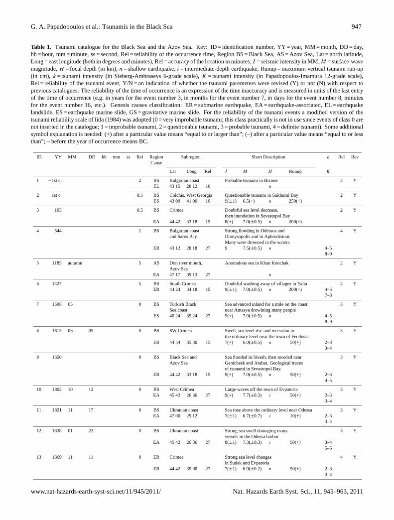
Table 1. Tsunami catalogue for the Black Sea and the Azov Sea. Key: ID = identification number, YY = year, MM = month, DD = day,hh = hour, mm = minute, ss = second, Rel = reliability of the occurrence time, Region BS = Black Sea, AS = Azov Sea, Lat = north latitude,Long = east longitude (both in degrees and minutes), Rel = accuracy of the location in minutes,I = seismic intensity in MM,M = surface-wavemagnitude,H = focal depth (in km),n = shallow earthquake,i = intermediate-depth earthquake, Runup = maximum vertical tsunami run-up(in cm), k = tsunami intensity (in Sieberg-Ambraseys 6-grade scale),K = tsunami intensity (in Papadopoulos-Imamura 12-grade scale),Rel = reliability of the tsunami event, Y/N = an indication of whether the tsunami paremeters were revised (Y) or not (N) with respect toprevious catalogues. The reliability of the time of occurrence is an expression of the time inaccuracy and is measured in units of the last entryof the time of occurrence (e.g. in years for the event number 3, in months for the event number 7, in days for the event number 8, minutesfor the event number 16, etc.). Genesis causes classification: ER = submarine earthquake, EA = earthquake-associated, EL = earthquakelandslide, ES = earthquake marine slide, GS = gravitative marine slide. For the reliability of the tsunami events a modified version of thetsunami reliability scale of Iida (1984) was adopted (0 = very improbable tsunami; this class practically is not in use since events of class 0 arenot inserted in the catalogue; 1 = improbable tsunami, 2 = questionable tsunami, 3 = probable tsunami, 4 = definite tsunami). Some additionalsymbol explanation is needed: (+) after a particular value means “equal to or larger than”; (–) after a particular value means “equal to or lessthan”; – before the year of occurrence means BC.
ID YY MM DD hh mm ss Rel Region Subregion Short Description k Rel RevCause
Lat Long Rel I M H Runup K
1 −1st c. 2 BS Bulgarian coast Probable tsunami in Bizone 3 YEL 43 15 28 12 10 n
2 1st c. 0.5 BS Colchis, West Georgia Questionable tsunami in Sukhumi Bay 2 YES 43 00 41 00 10 9(±1) 6.5(+) n 250(+)
3 103 0.5 BS Crimea Doubtful sea level decrease, 2 Ythen inundation in Sevastopol Bay
EA 44 42 33 18 15 8(+) 7.0(±0.5) n 200(+)
4 544 1 BS Bulgarian coast Strong flooding in Odessus and 4 Yand Saros Bay Dionysopolis and in Aphrodisium.
Many were drowned in the waters.ER 43 12 28 18 27 9 7.5(±0.5) n 4–5
8–9
5 1185 autumn 5 AS Don river mouth, Anomalous sea in Khan Konchak 2 YAzov Sea
EA 47 17 39 13 27 n
6 1427 5 BS South Crimea Doubtful washing away of villages in Yalta 2 YER 44 24 34 18 15 9(±1) 7.0(±0.5) n 200(+) 4–5
7–8
7 1598 05 0 BS Turkish Black Sea advanced inland for a mile on the coast 3 YSea coast near Amasya drowining many people
ES 40 24 35 24 27 9(+) 7.0(±0.5) n 4–58–9
8 1615 06 05 0 BS SW Crimea Swell, sea level rise and recession to 3 Ythe ordinary level near the town of Feodosia
ER 44 54 35 30 15 7(+) 6.0(±0.5) n 50(+) 2–33–4
9 1650 0 BS Black Sea and Sea flooded in Sivash, then receded near 3 YAzov Sea Genichesk and Arabat. Geological traces
of tsunami in Sevastopol Bay.ER 44 42 33 18 15 9(+) 7.0(±0.5) n 50(+) 2–3
4–5
10 1802 10 12 0 BS West Crimea Large waves off the town of Evpatoria 3 YEA 45 42 26 36 27 9(+) 7.7(±0.3) i 50(+) 2–3
3–4
11 1821 11 17 0 BS Ukranian coast Sea rose above the ordinary level near Odessa 3 YEA 47 00 29 12 7(±1) 6.7(±0.7) i 10(+) 2–3
3–4
12 1838 01 23 0 BS Ukranian coast Strong sea swell damaging many 3 Yvessels in the Odessa harbor
EA 45 42 26 36 27 8(±1) 7.3(±0.3) i 50(+) 3–45–6
13 1869 11 11 0 ER Crimea Strong sea level changes 4 Yin Sudak and Evpatoria
ER 44 42 35 00 27 7(±1) 6.0(±0.2) n 50(+) 2–33–4
www.nat-hazards-earth-syst-sci.net/11/945/2011/ Nat. Hazards Earth Syst. Sci., 11, 945–963, 2011

948 G. A. Papadopoulos et al.: Tsunamis in the Black Sea
Table 1. Continued.
ID YY MM DD hh mm ss Rel Region Subregion Short Description k Rel RevCause
Lat Long Rel I M H Runup K
14 1875 07 25 0 BS Western coast Water was agitated and foamed 3 Yof Crimea
EA 44 30 33 18 15 7(±1) 5.5(±0.5) n 10(+) 2–33–4
15 1901 03 31 0 BS Bulgarian coast Tsunami inundation in Balchik 3 YER 43 24 28 42 27 9(±1) 7.1(±0.3) n 250(+) 2–3
3–4
16 1905 10 04 22 29 0 BS NE coast of Waves off Anapa, Russia, 3 YBlack Sea shook up a ship
EA 44 42 37 24 15 7(±1) 5.1(±0.7) n 2–33–4
17 1909 04 08 0 BS Western Caucasus Three waves off Cape Idokopas 3 YGS 44 15 38 07 2–3
3–4
18 1927 06 26 11 20 0 BS South Crimea Sea level changes and roughness 4 Yin Kerch Strait near Yalta
ES 44 24 34 24 10 7(±1) 6.0(±0.1) n 30 2–33–4
19 1927 09 11 22 15 0 BS South Crimea In Balaklava the sea advanced inland 4 Y15 m; two houses were destroyed
ER 44 18 34 18 10 8(±1) 6.8(±0.1) n 100 3–45–6
20 1927 09 16 08 21 0 BS South Crimea Sea level changes in Balaklava 4 YEA 44 18 34 00 10 5(±1) 4.9(±0.3) n 30(+) 2–3
3–4
21 1939 12 26 23 57 0 BS Turkish coast Sea receded 100 m inUnye; tide- 4 Yand East gauge records of max. heightBlack Sea of 53 cm in Novorossiisk
ES 39 30 39 30 15 10(±1) 7.9(±0.1) n 53 2–33–4
22 1966 07 12 18 53 0 BS Crimea, Anapa Tide-gauge records of max. height 4 Yof 50 cm in Gelendzhik 4 Y
ES 44 42 37 12 10 7(±1) 5.8(±0.5) n 42 2–33–4
23 1968 09 03 08 19 BS Black Sea In the Big Port, Amasra, the water 4 YTurkish coast rose 3 m and moved boats onshore
ER 41 49 32 23 10 9(±1) 6.6(±0.2) n 300 3–44–5
24 1970 12 04 01 59 0 BS East Black Sea Sea oscillations with heights of 80 cm 3 Yand period of 5 min in Sochi
ER 43 42 38 30 10 7(±1) 5.8(±0.5) 40 1–22–3
25 1990 08 02 0 BS South coast of A sudden short-lived sea level 3 YAzov Sea rise of 40 cm
GS? 45 38 36 31 40 23
26 2007 05 07 0 BS Bulgarian Black Tsunami-like sea disturbance lasting for 4 YSea coast several hours; small fishing boats were
cast onto the beach in Kavarna and BalchikGS? 43 06 28 36 120 3–4
4–5
Nat. Hazards Earth Syst. Sci., 11, 945–963, 2011 www.nat-hazards-earth-syst-sci.net/11/945/2011/

G. A. Papadopoulos et al.: Tsunamis in the Black Sea 949
In this paper, when sufficient data were available we re-evaluated intensitiesk and K in the 6-grade and 12-gradescales, respectively.
In the next lines 26 events are described and evaluated.Earthquake epicenters and other sources of tsunamigenicevents were plotted in Fig. 1.
[1], –1st century, Bizone (Kavarna, Bulgarian Black Seacoast)
coordinates: 43◦15′ N, 28◦12′ Ecause: ELreliability: 3
This is a puzzling event which is mentioned by Strabo(64 BC–19 AD):
“΄Εν τω μεταξύ δε διαστήματι τω από Καλλάτιδος εις Απολλωνίαν, Βιζώνη τε εστίν, ης κατεπόθη
πολύ μέρος υπό σεισμών…” that is “Between Kallatis[today Magalia] and Apollonia
[Sozoupolis]there is Bizone a large part of which submergedbecause of earthquakes . . .”. Bizone was located wherethe today town of Kavarna is situated a few kilometersto the north of Balchik. Nikonov (1997b) reported thatan early Armenian chronicler (Mowses Khorenatsi, 410–491 AD) mentioned a sudden flooding of the southern shoresof the Black Sea back in the legendary times of the 1stcentury BC.
According to Gergova et al. (1995), archaeologicalobservations in the Thracian Necropolis at Sveshtari, NEBulgaria, have established that in about the 3rd century BC astrong earthquake occurred there. These authors suggestedthat it was presumably the same earthquake that causedthe nearby city of Bizone to slide into the sea. However,there is not any tsunami record. From the geoscientificpoint of view, Christoskov et al. (1995) suggested thatgeomorphological observations supported by the historicalevidence indicated that the destruction of a large part of theChirakman Cape, where ancient Bizone was situated, wascaused by massive landslide induced by strong earthquakesin a period between the 1st and 4th century BC. During thesame events the town of Dionisopolis, today Balchik, wasprobably damaged. Christoskov et al. (1995) concluded thatthey cannot exclude that the damage observed in Sveshtariarea might been related to landsliding in Bizone. Again,there is no tsunami record in Bizone. Certainly, one maynot rule out the reasonable scenario that massive landslidingcaused a locally strong tsunami. In fact, tsunami evidence isprovided by sediment deposits found to the north of Varnaat 43◦18′ N/28◦18′ E. The deposits were radiocarbon datedat about 2000 years BP and attributed to a large magnitude(M > 7.0) earthquake (Ranguelov, 2003). However, thedating result is unstable and susceptible to large error.Levelling measurements indicated a wave run-up of 7–8 m.
We concluded that the strong earthquake which is evidentthrough historical, archaeological and geomorphologicalevidence, was possibly the one that caused landslides and alocal tsunami in Bizone probably during the 1st century BC.However, the little information available is not sufficient toestimate tsunami intensity.
Further references: Shebalin et al. (1974).
[2], 1st century, Sukhumi Bay/Colchis (West Georgia)
coordinates: 43◦00′ N, 41◦00′ Ecause: ESreliability: 2
Nikonov (1994, 1997a, b) and Dotsenko (1995), basedon Russian sources, reported that the submergence of thetown of Dioskuriada on the coast of Sukhumi Bay, Colchis,in West Georgia today, can be inferred from both locallegends and town remains in the bay bottom. A rapidsubsidence by 2–3 m was related to a catastrophic earthquakeof M ≥ 6.5 occurring in the earlier half of the 1st century.Nikonov (1997a) estimated that the event took place inAD 20±20 but it is not absolutely clear how he reached thatresult. He suggested also that although no direct evidencefor a tsunami was found, it may have occurred, judging fromsimilar cases elsewhere on the globe, and that the run-upheight exceeded 2.5 m the tsunami intensity beingk = IV−V.This information was also repeated by Pelinovsky (1999) andYalciner et al. (2004) who considered a tsunami intensity ofK = IV−VI. However, we believe that the little informationavailable is not sufficient to estimate tsunami intensity.
[3], 103 AD, Sevastopol Bay (Crimea)
coordinates: 44◦42′ N, 33◦18′ Ecause: EAreliability: 2
Nikonov (1997a, b) based his conclusions on the St.Clements’ miracles as well as on archaeological evidence fordamage caused in settlements in the Sevastopol Bay, Crimea,and suggested that a strong earthquake ofM ∼ 7 occurring atthe beginning of the 2nd century AD, possibly in 103 AD,caused a strong tsunami in the bay. He estimated that thesea receded 500 m, and occasionally 3–4 km, and that thewave run-up was at least 2 m. The intensity of this tsunamiwas estimated ofk = III (Nikonov, 1997a) or ofK = III−IV(Yalciner et al., 2004). We believe that the little informationavailable is not sufficient to estimate tsunami intensity.
www.nat-hazards-earth-syst-sci.net/11/945/2011/ Nat. Hazards Earth Syst. Sci., 11, 945–963, 2011

950 G. A. Papadopoulos et al.: Tsunamis in the Black Sea
[4], 544/545, Odessus and Dionysopolis (NE BulgarianBlack Sea), Aphrodisium (Saros Bay/NE Aegean Sea)
coordinates: 43◦12′ N, 28◦18′ Ecause: ERtsunami intensity: 4–5/8–9reliability: 4
This is a key event in the historical earthquake andtsunami record of the Bulgarian Black Sea coast althoughit is puzzling from several points of view. Historicaldocumentation of a possible tsunami event can be found intexts of the Byzantine chronographers Malalas, Cedrenus,Glykas, and Theophanes. In addition to that event, anearthquake occurred also in Cyzicus, today Banderma, inthe south Marmara Sea (Fig. 1) (see reviews by Georgiades,1904; Ambraseys, 1962; Antonopoulos, 1973; Evagelatou-Notara, 1987/88; Guidoboni et al., 1994). Ambraseys (1962)considered the earthquake to have occurred in the winterof 542 and that the tsunami affected not only the Seaof Marmara and the Thracian coasts but also the Gulf ofEdremit, which is strange enough, given the its distantlocation on the Aegean coast of Asia Minor (Fig. 1).Antonopoulos (1973) copied uncritically Ambraseys (1962).On the basis of the account of Theophanes, Evagelatou-Notara (1987/88) accepted that the earthquake in Cyzicusoccurred on 6 September 543.
A careful historical study was performed by Guidoboni etal. (1994) who distinguished between two separate events.The first was a destructive earthquake that hit Cyzicus on6 September 543, but there is very weak evidence for tsunamioccurrence associated with the earthquake. The second eventwas a destructive sea wave taking place in 544/545 andflooding three coastal zones, two of today’s Bulgarian coastsat the Black Sea and one at Thrace; namely at Odessus,later Tiveriopolis, and today’s Varna; Dionysopolis, todayBalchik, situated 20 km to the north of Varna; Aphrodisium,situated on the Thracian Peninsula at the Xeros (todaySaros) Bay, Northeast Aegean Sea (Fig. 1). In fact,Theophanes (224) reported that “In this year[544/545] thesea advanced on Thrace by four miles[ca. 6 km]and coveredit in the territories of Odessus and Dionysopolis and alsoAphrodisium. Many were drowned in the waters. ByGod’s command the sea then retreated to its own place”(English translation by Guidoboni et al., 1994). Thedescriptions found in Cedrenus (657) are similar; he placedthe event again in 544/545 but Glykas (269) placed it in 557.Malalas (481) mentioned only briefly a destructive sea wave.
In his tsunami review, Nikonov (1997a, b) reproducedthe Byzantine information and assumed that there wasa tsunami with run-up heights exceeding 2–4 m causedby a shallow earthquake ofM = 7.5 ± 0.5 occurringoffshore at Varna in AD 543± 1. Pelinovsky (1999) andYalciner et al. (2004) reproduced the earthquake parametersassumed by Nikonov (1997a). Zaitsev et al. (2002)
copied Pelinovsky (1999). Yalciner et al. (2004) estimatedthat the tsunami intensityK was of VIII–X degree inthe new 12-grade scale introduced by Papadopoulos andImamura (2001).
Altinok and Ersoy (2000) considered a confusing mod-ification of the suggestion of Guidoboni et al. (1994)about two separate events and listed the first event, ofreliability 2, occurring in 542 on the coast of Thracebut also in Edremit gulf withk = 4, the estimation takenfrom Ambraseys (1962). They adopted 66 September 543as the date of the second event occurring on Kapidagpeninsula, in Erdek and Banderma but also in Edremitgulf. Altinok and Ersoy (2000) assigned reliability 3 to thesecond event. However, there is no evidence, neither inthe Byzantine chronicles nor elsewhere, that the sea wavewas also observed in Edremit gulf which implies that theaccount of Ambraseys (1962) was erroneus. Papazachosand Papazachou (2003) followed Guidoboni et al. (1994)and assumed also two events: one earthquake in Cyzicuson 6 September 543 and another in 544. For the secondearthquake they assumed an epicenter of about 100 km tothe south of the one proposed by Nikonov (1997a), itssuggested magnitude being 7.0±0.5, but they mentioned thatthe Byzantine sources do not explicitly attribute the wave toan earthquake.
Recent results of field observations in the archaeologicalsite of Cybele Temple in Balchik have indicated possibleinundation by the 544/545 sea wave. In fact, Ranguelovet al. (2008a) presented evidence that the Cybele Temple,which is of the Hellenistic period, was affected by fire androof collapse, very possibly due to a strong earthquake, andvery soon after the fire the floor was flooded by sea waterwhich left behind a layer of sand and shells. Ranguelov etal. (2008a) suggested that there was an earthquake-tsunamievent that affected the Cybele Temple in 543, which in factis the 544/545 one.
In summary, the large earthquake of 6 September 543 inCyzicus, Marmara Sea, was unrelated to the sea wave whichtook place in 544/545 in the coastal zone of Thrace. Inaddition, the tsunami reported by some authors as occurringin 557 is a false event (see Appendix A). The sea wave of544/545, which for all evidence had features of a tsunami,flooded the Bulgarian coastal zone of Odessus (Varna) andDionysopolis (Balchik). This piece of information fitsthe field observations performed in the Cybele Temple inBalchik which indicated that the sea wave was a tsunamitriggered by a strong earthquake. In the historical documents,however, Aphrodisium in Saros Bay, NE Aegean Sea, wasalso mentioned as being affected by the sea wave. Then, aquestion is raised as to the possibility of a strong earthquakehaving its source offshore at Varna-Balchik and causinga tsunami not only in the Black Sea Bulgarian coast,which is reasonable, but also in Saros Bay, Thracian coast,that is at a distance of about 330 km from the epicentresuggested by Nikonov (1997a). A possible mechanism for
Nat. Hazards Earth Syst. Sci., 11, 945–963, 2011 www.nat-hazards-earth-syst-sci.net/11/945/2011/

G. A. Papadopoulos et al.: Tsunamis in the Black Sea 951
the tsunami initiation may involve a submarine landslideor slump in Saros Bay triggered by the earthquake. Fromempirical relations between earthquake magnitude and themaximum distance at which soil liquefaction or landslidecould be triggered (Papadopoulos and Lefkopoulos, 1993;Papadopoulos and Plessa, 2000), it results that magnituderanging between 7.3 and 7.6 is required. However, asmaller magnitude is required if the epicenter suggestedby Papazachos and Papazachou (2003) is adopted. It isnoteworthy that as analyzed later in 1901, an earthquake ofestimated magnitude 7.1 occurred at nearly the same seismicsource.
Further references: Milne (1912), Shebalin et al. (1974),Ambraseys (2009).
[5], autumn 1185, Khan Konchak, Don river mouth,Azov Sea
coordinates: 47◦17′ N, 39◦13′ Ecause: EAreliability: 2
This is an earthquake and tsunami event reported byNikonov (1997b) to have occurred at Khan Konchak nearthe mouth of Don river in the Azov Sea. That authorconcluded about the earthquake and tsunami occurrencefrom the interpretation of a passage from “The Lay of Igor’sHost”, a 12th century epic poem describing Prince Igor’scampaign against the nomad tribes. Nikonov (1997b) says:“The passage from the poem speaks of the sea bursting outat midnight and clouds, chased by hurricanes . . .” and “theground shook and moaned, rustling the tall grass, wakingup the nomads in their camp . . . This occurred in the autumnof 1185 . . .”. However, the description is not convincing,particularly for the tsunami event, and is thus considered oflow reliability by us.
[6], 1427, Yalta (South coast of Crimea)
coordinates: 44◦24′ N, 34◦18′ Ecause: ERtsunami intensity: 4–5/7–8reliability: 2
From legendary and folklore accounts of the 15th century,Nikonov (1997a, b) suggested that a very strong earthquakeof M = 7.0±0.5 associated with a tsunami occurred around1427 on the south coast of Crimea. It is said that severalvillages were washed away around the town of Yalta.Nikonov (1997a) estimated the tsunami intensity atk = IIIand the water level rise on the shore of at least 2 m. Yalcineret al. (2004) estimated intensity atK = II–IV. However, if thedescription “several villages were washed away” is correct,then the intensitiesk andK mentioned above underestimatedthe tsunami impact.
[7], May 1598, Amasya (Central North Anatolia)
coordinates: 40◦24′ N, 35◦24′ Ecause: EStsunami intensity: 4–5/8–9reliability: 3
Several documentary sources have indicated that in May1598 a major earthquake caused destruction in Amasyaand Corum in central northern Anatolia. In some of thesources the descriptions may imply the occurrence of astrong tsunami on the Turkish Black Sea coast: “. . . the seawas driven back drowning a few thousand people in townsand villages”; and “. . . in Amasya[the ground]was cleavedengulfing many villages”; and “. . . the sea advanced inlandfor a mile on the coast of the Black Sea, drowining manypeople” (see review in Ambraseys and Finkel, 1995). Altinokand Ersoy (2000, p. 192) reproduced the above informationand added that “The tsunami created by the earthquakein the gulf between Sinop and Samsun showed a waveheight of approximately 1 m (Nikonov, 1997b)”. However,we were unable to locate such an account in any of thepapers of Nikonov (1997a, b). The only relevant piece ofinformation found in Nikonov (1997b) is the plot on a mapof the coastal spot where he suggested that the tsunami wasobserved near Sinop with the indication “tsunami occurringfrom remote earthquake”. However, no reference is given.Ambraseys (2009) noted that the occurrence of a seismic seawave on the coast of the Black Sea, 100 km to the northof Amasya, is difficult to associate with the earthquake,unless it was associated with a massive submarine landslide.The intensity of this tsunami was estimated by Yalciner etal. (2004) to beK = II–IV. However, if the description thatmany people were drowned by the wave is correct, then thetsunami intensity has been underestimated and, therefore, weassigned a tsunami intensity of a higher degree.
Further references: Milne (1912), Shebalin et al. (1974).
[8], 5 June 1615, Feodosia (SW Crimea)
coordinates: 44◦54′ N, 35◦30′ Ecause: ERtsunami intensity: 2–3/3–4reliability: 3
Based on Armenian chronicles, Nikonov (1997a) listedan earthquake ofM = 6.0± 0.5 and an associated tsunamioccurring on 5 June 1615 on the southeastern coast of Crimeawith the next description: “Swell, sea level rise and recessionto the ordinary level near the town of Feodosia.” He alsoestimated the water level rise to be 0.5 to 1.0 m and thetsunami intensityk = II. According to Yalciner et al. (2004),the tsunami intensityK was estimated between II and IV. Wehave estimated it as shown above.
www.nat-hazards-earth-syst-sci.net/11/945/2011/ Nat. Hazards Earth Syst. Sci., 11, 945–963, 2011

952 G. A. Papadopoulos et al.: Tsunamis in the Black Sea
[9], 1650, Sivash (Azov Sea)
coordinates: 44◦42′ N, 33◦18′ Ecause: ERtsunami intensity: 2–3/4–5reliability: 3
This was an earthquake (M = 7.0±0.5) and tsunami eventreported by Nikonov (1997a) to have occurred in 1650 inthe western shores of the Azov Sea as well as in the BlackSea: “Sea flooded the shore to connect with the Sivash, thenthe water receded near Genichesk and Arabat. Geologicaltraces of tsunami in the Sevastopol Bay” in Crimea. He alsoestimated a water level rise of 0.5 to 1.0 m and a tsunamiintensity k of degree III. We have estimated it as shownabove.
[10], 12 October 1802, Evpatoria (western Crimea)
coordinates: 45◦42′ N, 26◦36′ Ecause: EAtsunami intensity: 2–3/3–4reliability: 3
This was a large, intermediate-depth earthquake of anestimated magnitude of 7.7 occurring at the Vranceaseismic source, Romania (Constantinescu and Marza, 1989;we adopted focal parameters estimated by them). Theearthquake was perceptible at very long distances, fromSt. Petersburg to the north, to Ithaki island in Ionian Seato the south, but it was highly destructive in Bucharest(von Hoff, 1841; Mallet, 1855). The very long radius ofperceptibility is a common feature of the intermediate-depthearthquakes of Vrancea as well as those of the Hellenic arcand elsewhere.
From Russian sources, Nikonov (1997a) listed theearthquake and an associated tsunami: “Large waves offthe town of Evpatoria, at western coast of Crimea, in calmweather.” However, the description for large waves is notcompatible with the same author’s estimated maximum waterlevel rise of ≥ 0.5 m. The estimated tsunami intensitywas k = II. The mechanism which triggered the waves waspossibly a submarine slump caused by the earth shaking.From empirical relations between earthquake magnitude andthe maximum distance,R, at which soil liquefaction orlandslide could be triggered (see similar analysis for theevent [4] of 544/545 AD), it results that forM = 7.7 we getR = 340 km andR = 620 km, respectively. The epicentraldistance of Evpatoria is about 750 km, which is very long.However, it should be noted that the above empiricalrelations are valid for shallow earthquakes since no suchrelations were produced for intermediate-depth earthquakesdue to the scarcity of data. On the other hand, Evpatoriais situated in the area of maximum seismic perceptibility.
Therefore, we do not rule out that the sea wave in that localitywas due to a submarine ground failure triggered by the earthshaking.
Further references: Milne (1912), Shebalin et al. (1974),Yalciner et al. (2004).
[11], 17 November 1821, Odessa (Ukraine)
coordinates: 47◦00′ N, 29◦12′ Ecause: EAtsunami intensity: 2–3/3–4reliability: 3
This was a strong earthquake which caused some damageto buildings at Jassy, Moldavia, and was felt in Kievand other Ukranian localities and as far as Tiflis inGeorgia (von Hoff, 1841; Mallet, 1855). From Russiansources, Nikonov (1997a) listed the earthquake with anestimated magnitude of 6.7 ± 0.7 and an associated sealevel disturbance: “Sea rose above the ordinary level nearthe town of Odessa by more than 10 cm; k=II.” A similardescription, again from Russian sources, was given byDotsenko (1995) and Pelinovsky (1999) and it was repeatedby Yalciner et al. (2004). In the catalogue of Shebalinet al. (1974), the earthquake was classified as one ofintermediate-depth and its epicentral location was estimatedto be the same as that of the previous event of 1802. Theseparameters were also adopted by Nikonov (1997a). Thenagain, the question is raised of the mechanism that causedthe sea level rise in Odessus at an epicentral distance ofabout 440 km. We repeated the calculations as we haddone with the previous event of 1802 and found that forM = 6.7, a maximum distance at which soil liquefactionor landslide could be triggered isR = 80 km and R =
110 km, respectively. These distances are too short evenfor intermediate-depth earthquakes to cause ground failures440 km away from the epicenter. Then, two alternativesmight be considered. The first is that the epicenter iscorrectly placed and the sea disturbance was only a standingwave (seiche) caused by the seismic ground vibration.Another possibility is that the earthquake was not associatedwith the Vrancea seismic source, that the above epicenter isnot correctly placed and that it should be shifted more to theNorth. This last solution is our favoured one. Then, the seadisturbance could be attributed equally either to a submarineslump or to a seiche.
Further references: Milne (1912).
Nat. Hazards Earth Syst. Sci., 11, 945–963, 2011 www.nat-hazards-earth-syst-sci.net/11/945/2011/

G. A. Papadopoulos et al.: Tsunamis in the Black Sea 953
[12], 23 January 1838, Odessa (Ukraine)
coordinates: 45◦42′ N, 26◦36′ Ecause: EAtsunami intensity: 3–4/5–6reliability: 3
This was another large, intermediate-depth earthquake ofan estimated magnitude of 7.3 occurring at the Vranceaseismic source, Romania (Constantinescu and Marza, 1989;we adopted focal parameters estimated by them). Theearthquake became perceptible at long distances but not sofar away as the 1802 one (von Hoff, 1841; Mallet, 1855).In Transylvania the buildings first rocked from side to sideand then the walls cracked and fell. From Russian sources,Nikonov (1997a) listed the earthquake and an associatedsea disturbance: “Strong sea swell damaging many vesselsin the Odessa harbor.” He estimated a tsunami intensityof k = II. Yalciner et al. (2004) based their findings on theinformation provided by Nikonov (1997a) and estimated atsunami intensity ofK = VII–VIII degree on the new 12-grade scale of Papadopoulos and Imamura (2001). On thesame scale, we prefered to assign a conservative intensity ashigh as V–VI degree.
Further references: Milne (1912), Shebalin et al. (1974).
[13], 11 November 1869, Sudak and Evpatoria (Crimea)
coordinates: 44◦42′ N, 35◦00′ Ecause: ERtsunami intensity: 2–3/3–4reliability: 4
Based on Russian sources, Nikonov (1997a) listed ashallow earthquake (M = 6.0±0.2) and a tsunami event inCrimea: “Town of Sudak: a violent horizontal recession ofthe sea by 2 m and a slow return to the ordinary level in10 min. A strong tidal wave as high as 1 m near the townof Evpatoria.” He estimated tsunami intensity to bek = I–III.Again from Russian sources, Dotsenko (1995) described theevent shortly as follows: “The earthquake had intensity 7–8in Yalta, Sevastopol and Sudak. The sea was stormy.” (seealso in Pelinovsky, 1999). Yalciner et al. (2004) summarizedthe above information and estimated that the intensity of thistsunami can be considered atK = II–IV. We estimated it asshown above. Earthquake parameters were adopted fromNikonov (1997a).
Further references: Montandon (1953).
[14], 25 July 1875, Western coast of Crimea
coordinates: 44◦30′ N, 33◦18′ Ecause: EAtsunami intensity: 2–3/3–4reliability: 3
A Russian source indicated that a moderate earthquake ofM = 5.5±0.5 caused some sea disturbance with estimatedtsunami intensityk = I–III: “ Western coast of Crimea. Waterwas agitated and foamed” (Nikonov, 1997a). Yalcineret al. (2004) summarized the information provided byNikonov (1997a) and estimated that the intensity of thistsunami could be considered atK = II–III. We estimated itas shown above. The earthquake parameters were adoptedfrom Nikonov (1997a).
Further references: Milne (1912), Montandon (1953).
[15], 31 March 1901, Balchik (North Bulgarian Black Seacoast)
coordinates: 43◦24′ N, 28◦42′ Ecause: ERtsunami intensity: 2–3/3–4reliability: 3
A large earthquake ofM = 7.1 and maximum intensity ofX degree (MSK) or IX–X (EMS) occurred offshore Shabla-Kaliakra, NE Bulgaria, causing surface landslides of severalkm and subsidence of about 3 m. “The boats in the port ofBalchik were uplifted about the same altitude” (Ranguelov,1996). This information came from an eyewitness reviewedin early 70’s by B. Ranguelov. Tsunami inundation witha maximum height of about 2.5–3 m was reported by aneyewitness at the Balchik port (Grigorova and Grigorov,1964).
[16], 4 October 1905, Anapa (NE Black Sea)
coordinates:44◦42′ N, 37◦24′ Ecause: EAtsunami intensity: 2–3/3–4reliability: 3
From Russian sources, sea waves were described inassociation with a moderate (M = 5.1) earthquake nearAnapa: “NE coast of Black Sea near the town of Anapa.Waves off Anapa shook up a ship. Maximum water levelrise ≥ 0.5m, k=II. Earthquake magnitudeM = 5.1± 0.7”(Nikonov, 1997a); “Submarine earthquake ofM = 7 wasregistered in the vicinity of the town of Anapa, Russia. Thewaves were so large at the sea surface that they bounced thevessel. Five shocks were felt” (Grigorash and Korneva, 1969;also Dotsenko, 1995; Pelinovsky, 1999). The intensity ofthis tsunami can be considered atK = III–VI (Yalciner et al.,2004).
www.nat-hazards-earth-syst-sci.net/11/945/2011/ Nat. Hazards Earth Syst. Sci., 11, 945–963, 2011

954 G. A. Papadopoulos et al.: Tsunamis in the Black Sea
[17], 8 April 1909, Cape Idokopas (Western Caucasus)
coordinates: 44◦15′ N, 38◦07′ Ecause: GStsunami intensity: 2–3/3–4reliability: 3
Nikonov (1997a) based his findings on a Russian sourceand described an aseismic case of sea waves observed offthe coast of Western Caucasus: “Off the NE coast of BlackSea near Cape Idokopas. Three waves off Cape Idokopas.”Although no information was provided about the featuresof the wave, he suggested that tsunamis may arise in theBlack Sea not only from large seismic events, but also fromunderwater slides, and that this was most likely the causeof the 1909 tsunami when the wave height in the opensea above the continental slope reached 3–5 m. To supporthis suggestion, Nikonov (1997a) noticed that an underwatercable broke twice due to moderately sized earthquakes thatoccurred in the NE Caucasus in 1870. He added alsothat abundant turbidites in near-surface sea deposits off theCaucasian, Crimean, and Bulgarian coasts also confirmed theconclusion that underwater slides occurred there. In fact,a recent case observed along the Bulgarian coast in 2007was described and studied by Ranguelov et al. (2008b) (seedetails later). The generation of tsunamis from submarinelandslides or slumps is well-known also in the easternMediterranean Sea (Papadopoulos, 2003; Perissoratis andPapadopoulos, 1999) but also elsewhere (e.g. Tappin et al.,1999).
[18], 26 June 1927, Yalta (South Crimea)
coordinates: 44◦24′ N, 34◦24′ Ecause: EStsunami intensity: 2–3/3–4reliability: 4
Data published in Russian sources have shown that astrong earthquake with a magnitude of 6.0 occurred possiblyon the submarine slope south of Yalta and caused a localtsunami on the south coast of Crimea. Dotsenko (1995) andDotsenko and Konovanov (1996) published data from Soviettide-gauge stations that recorded the event with maximumheight of 24 cm at Yalta station, the heights in another fivestations ranging from 6 to 14 cm (Table 2). Eyewitnessesnoted that the sea bottom topography changed with theearthquake by a downward shift of silt on submarine rocksalong the Crimean coastal zone, and that “changes in the sealevel in the western and eastern parts of the Kerch Strait and,in general, the sea was stormy and rough throughout theentire earthquake” (Dotsenko, 1995, from various Russiansources; also Pelinovsky, 1999). According to the datacollected by Nikonov (1997a), in the Gurzuf village thesea receded by 1.5 m, then came back again to the shore.In Yalta, the sea level fell by 0.18 m and then rose by
0.16 m. In Sevastopol, a maximum sea level rise of 0.16–0.32 m was observed. These values correspond to readingsin tide records (Table 2). In Alupka, the sea receded andthen returned onto the shore and overwhelmed the beach.Sea disturbance was also reported from Feodosia, Alushta,Tuapse, Sudak, Novorossiisk and Kerch. The intensity of thistsunami was estimated atk = II (Nikonov, 1997a) orK = III–IV (Yalciner et al., 2004). Among the written sources thatNikonov (1997a) listed for this tsunami event is that ofAntonopoulos (1979), which, however, is a false referencebecause no Black Sea tsunamis are studied in the paper ofAntonopoulos (1979) .
Considering the eyewitness acounts, we are in favour ofthe suggestion that the tsunami of 26 June 1927 was triggeredby submarine slumps initiated by the earthquake.
[19], 11 September 1927, South Crimea
coordinates: 44◦18′ N, 34◦18′ Ecause: ERtsunami intensity: 3–4/5–6reliability: 4
After the event of 26 June 1927, an even larger anddestructive earthquake of magnitude 6.5 occurred in theCrimean region. The epicenter co-ordinates were situatedon the slope of the Black Sea trough, 20 km south-east ofYalta. In the open sea, near the seismic source, fishermenobserved sea surface variations and roughness (Dotsenko,1995; Pelinovsky, 1999). From several Russian sourcesreviewed by Nikonov (1997a) it results that in Balaklava, tothe south of Sevastopol, the sea receded in the bay by 0.6–1.0 m, then rushed onto the shore and overwhelmed a vastexpanse (15 m) rising by 0.5 m; two houses were destroyed.In Sevastopol, ebb up to 0.5 m was observed, while inYalta first a rapid fall and then oscillation at 0.37 m werereported. Sea level rise was also reported in other localities(Table 2).
The earthquake was accompanied by tsunami wavesrecorded on tide gauges with height of 39 cm in Evpatoria,35 cm in Yalta, 23 cm in Sevastopol, 18 cm in Novorossiiskand Tuapse, and 20 cm in Batumi (Dotsenko and Konovanov,1996). The intensity of this tsunami was estimated ask = IIby Nikonov (1997a).
[20], 16 September 1927, South Crimea
coordinates: 44◦18′ N, 34◦00′ Ecause: EAtsunami intensity: 2–3/3–4reliability: 4
An aftershock,magnitude of 4.9 of the mainshock,12 September 1927, caused the sea water to recede and thento rise more than 0.3 m in the bay of Balaklava. The intensity
Nat. Hazards Earth Syst. Sci., 11, 945–963, 2011 www.nat-hazards-earth-syst-sci.net/11/945/2011/

G. A. Papadopoulos et al.: Tsunamis in the Black Sea 955
of this tsunami was estimated atk = II (Nikonov, 1997a) orK = III–IV (Yalciner et al., 2004) in the new 12-grade scaleintroduced by Papadopoulos and Imamura (2001).
[21], 26 December 1939, Fatsa (Black Sea coast of NorthTurkey)
coordinates: 39◦30′ N, 39◦30′ Ecause: EStsunami intensity: 2–3/3–4reliability: 4
This earthquake (M = 7.9) occurred at 23:57 GMT of26 December 1939 rupturing a long segment of the NorthAnatolian Fault. It was one of the largest earthquakesever recorded instrumentally in the eastern MediterraneanSea. A description of the earthquake and its effects weresummarized by Richter (1956, p. 612–613) as follows. Lossof life was between 20 000 and 30 000 although a figure of40 000 was reported (Altinok and Ersoy, 2000); over 30 000dwellings were destroyed. The four largest communitieswhere the majority of structures were destroyed were(from east to west) Ercincan, Susehri (Endires), Koyulhisar(Misas), Resadiye, and Niksar (Neocaesarea). Faultingand high intensity extended from east of Erzincan to nearNiksar, about 340 km. The meizoseismal zone, followingthe fault line, was about 15 km wide. The area over whichthe shock was felt was roughly elliptical, with major andminor axes of about 1300 and 600 km. At some pointsin and near towns there was clear evidence of strike-slipfaulting showing right-hand offset, amounting up to 3.7 m.According to Richter (1956)the best available epicenter asdetermined by Gutenberg for the great earthquake is near391/2
◦ N, 391/2◦ E, near Erzincan. This epicenter is at a
distance of about 160 km from the closest Black Sea coast innorth Turkey.
Parejas et al. (1942; after Altinok and Ersoy, 2000)mentioned that a person in Fatsa, to the east of Sinop, wantedto dive into the sea instinctively at the time of the earthquake,but he was not able to reach the sea because it had recededabout 50 m. After a while, when the sea came back, theedge of the coast advanced 20 m. According to observationscollected by Altinok and Ersoy (2000) during the earthquakethe sea receded 100 m inUnye and sunken rocks appeared forthe first time. The sea also receded for 50–60 s in Giresun.Moreover, in Ordu, the people at the harbour saw that the seainitially became quiet, then receded about 15 m. The level ofthe sea returned to normal in 5–10 min.
The tsunami crossed mainly the eastern part of theBlack Sea and was recorded on tide gauges in Sovietharbors with a height of 50 cm in Sevastopol as well asin Novorossiisk (53 cm), in Tuapse (40 cm) and in otherstations (Grigorash and Korneva, 1969, 1972; Dotsenko,1995; Nikonov, 1997a; Pelinovsky, 1999) (Table 2). Yalciner
et al. (2004) estimated that the intensity of this tsunami canbe consideredK = III–V while Nikonov (1997a) tentativelyestimatedk = IV.
That the rupture zone of the earthquake is situated along distance inland from the north coast of Turkey, wherethe tsunami was observed, makes it difficult to understandthe tsunami generation mechanism. This is exactly whyRichter (1956) noted that since the mainshock epicenterwas certainly on land, the sea motion in Fatsa is important.Grigorash and Korneva (1969) noted that the tsunami beganwith the rise of the sea level in all stations except Batumi,which was the nearest USSR tide gauge to the earthquakeepicenter. This station first recorded a fall of the sea levelbeginning at 23:57 GMT on 26 December, exactly at the timeof the mainshock. Those authors compared the calculatedwave travel-times with the observed ones and suggestedthat the tsunami was either on the Black Sea shore nearthe Turkish coast, between Batumi and Sinop, or inland,and it is unknown if the tsunami was caused by tectonicmovement or by landslide. Nikonov (1997a) suggestedthat although no landslide-triggered tsunamis by teleseismicinland earthquakes have been reported in the Black Sea,“ they can be assumed for the East Anatolia earthquake of1939 . . .” Pelinovsky (1999) proposed three possibilities asfor the tsunami source: (i) ground rupture, (ii) secondaryfault believed to be associated with the dislocation motionin the Black Sea, (iii) submarine landslide triggered by theearthquake in the Black Sea. Yalciner and Pelinovsky (2004)investigated the possible source mechanism by comparingresults of the numerical modeling of the tsunami with theobservational data and the instrumental records, but they didnot reach a conclusive result.
Our favoured solution is the one which involves a co-seismic sediment slump at the continental slope of theBlack Sea north coast of Turkey between Sinop and Batumi.This scenario is supported by the fact that a negative wavephase was first recorded at Batumi, a feature which ischaracteristic at stations situated at the shore facing thetsunami source of landslide type (e.g. Papadopoulos et al.,2007). The empirical relations ofM/R for co-seismic groundfailures applied earlier in the examination of the events of544/545 AD and 1802, indicate that forM = 7.9 distanceRexceeds 160 km, that is the seismic triggering of submarineslump between Sinop and Batumi was quite possible.
An unusual hypothesis was put forward byBernaerts (2005) who suggested that the tsunami mayhave contributed, though in a small measure, to the widerregional conditions leading to the severe war winter of1939/40. According to this suggestion the tsunami wavesreleased enough “energy” stored at sea surface to enablethe formation of forceful low pressure on the north coastof Turkey within hours of the quake. At a level of 20 to40 m below the surface, the Black Sea still has a substantialportion of the summer heat at hand in December. Further,its surface and deep-water bodies are of different hydro
www.nat-hazards-earth-syst-sci.net/11/945/2011/ Nat. Hazards Earth Syst. Sci., 11, 945–963, 2011

956 G. A. Papadopoulos et al.: Tsunamis in the Black Sea
Table 2. Parameters of Black Sea tsunamis. Key:h = wave height (in cm),T = characteristic period of wave (in min),p = polarity of firstwave motion in the station,N = number of the highest wave,t = time of wave propagation from the tsunami source to the station, all theseparameters were recorded by Soviet tide-gauge stations and collected by Dotsenko (1995) and Dotsenko and Konovalov (1996) from severalsources, including Grigorash (1959a, b, 1972), Grigorash and Korneva (1969, 1972a, b) and Fomicheva et al. (1991);H = wave height (incm) summarized by Nikonov (1997a) from records of Soviet tide-gauge stations (Grigorash, 1972; Grigorash and Korneva, 1969, 1972b)and observations from a long number of other Russian sources. One may observe that in some instances the wave heights summarized byNikonov (1997a) are not consistent with those summarized by Dotsenko (1995) and Dotsenko and Konovalov (1996).
Station/ 26.06.1927 11.09.1927 26.12.1939 12.07.1966Observationpoint
h T p N t H h T p N t H h H h H
Odessa 5 9 + 3 189
Evpatoria 14 22 + 2 76 39 45 + 1 105
Balaklava 50–100
Sevastopol 16–32 23 45 + 2 35 ≥ 10 50
Yalta 24 22 + 2 8 16 35 35 – 2 9 37 14 2 2
Opasnoe 5
Feodosia 8 20 + 3 48 weak wave 13 30 + 2 59 25 10 3–4
Alupka 7
Kerch 6 23 + 1 159 13 50 + 1 184 13 24 9 3
Sudak 8
Novorossiisk 8 28 + 2 59 6 18 50 + 3 54 < 20 53 53
Gelendzhik 42 21
Alushta < 2
Tuapse 8 10 + 3 39 wave 19 8 + 2 49 15 40 40 8 5
Batumi 20 8 + 3 96 7 1 1
Mariupol 18 30 + 3 290 18 3
Fats 100
structure, the upper layer being rather thin and limited toabout 100–150 m, with certainly enough heat for an activecyclone towards the end of December.
[22], 12 July 1966, Anapa (Crimea)
coordinates: 44◦42′ N, 37◦12′ Ecause: EStsunami intensity: 2–3/3–4reliability: 4
This was a tsunami triggered by a moderate earthquake(M = 5.8) which occurred about 10 km offshore Anapa ata focal depth of 55 km. The tsunami wave was recordedby Soviet tide gauges as summarized in Table 2. One mayobserve that contradictory wave amplitudes were reportedby different authors. The highest amplitudes were 42 cm inGelendzhik, at 50 km to the south, and 10 cm in Feodosiaat 60 km across the Crimean Peninsula. The intensity ofthis tsunami can be consideredk = I (Nikonov, 1997a) or
K = III–V (Yalciner et al., 2004). The relatively smallearthquake magnitude disfavours tsunami generation by co-seismic faulting. Hence, submarine slump is a more likelymechanism.
At this point, it is of relevance to note that Dotsenko andIngerov (2007a) studied the digitized mareograms and thespectral features of the 26 July 1927, 11 September 1927,26 December 1939 and 12 July 1966 tsunami waves. Theyfound that as a rule, tsunami waves were characterized bythe initial elevation of the sea level and that the height ofthe first wave was not the maximum one. The maximumheights of the recorded tsunami waves at the points ofobservation did not exceeded 52 cm. For the major part ofpoints on the sea coast, they observed a noticeable trendtowards increase in the heights of waves with the magnitudeof the earthquake. The typical periods of tsunami wavesand background variations of the sea level lie within theintervals 8–39 min and 28–193 min, respectively. The sameauthors (Dotsenko and Ingerov, 2007b) performed analysisof the time spectra of the four tsunamis. For the analysis
Nat. Hazards Earth Syst. Sci., 11, 945–963, 2011 www.nat-hazards-earth-syst-sci.net/11/945/2011/

G. A. Papadopoulos et al.: Tsunamis in the Black Sea 957
of the spectra, they used digitized mareograms obtained for12 points of the Black Sea coast. The obtained spectrawere found, as a rule, multimode with one to four spectralmaxima. One maximum corresponds to the periods typicalof tsunami waves and the other maxima correspond to theoscillations of the sea level with lower frequencies. It seemslikely that the tsunami events were accompanied by low-frequency oscillations of the level caused by the atmosphericforcing, seiches, or other factors. In numerous cases, theoscillations from the predominant energy range lie outsidethe characteristic range of periods of the tsunami waves.
[23], 3 September 1968, Amasra (Black Sea coast of northTurkey)
coordinates: 41◦49′ N, 32◦23′ Ecause: ERtsunami intensity: 3–4/4–5reliability: 4
The Bartin earthquake was strong (M = 6.6) anddestructive, killing 24 persons. During this earthquake on theBlack Sea north coast of Turkey, the precipitous coastlinebetween Amasra and Cakraz uplifted by 35–40 cm, and thesea level lowered on the coastal rock. Because of thismussels and moss appeared (Ketin and Abdusselamoglu,1969; after Altinok and Ersoy, 2000). Lander (1969) reportedthat the sea receded 12 to 15 m in Cakraz at the onset ofthe earthquake and never returned entirely to its originallevel. In the Big Port of Amasra the water first drew back1.5 m. At the same time fish were jumping on the shorebut later the water rose 3 m, coming up to houses at thecoast and taking boats near a coffee house. At the Big Portalso, subsidence of∼25 cm occurred at the landing port forloading the submarines. Wedding (1968; after Altinok andErsoy, 2000) stated that the sea inundated 100 m in Amasraand after 14 min the second wave inundated the shore about50–60 m. This wave dragged many objects and caused manyboats to be stranded. The silent and unstopped progressionof the sea frightened the population. The reason for thisprogression was most probably the uplifting around Cakraz.According to Yalciner et al. (2004), the intensity of thistsunami can be considered asK = III–V on the new tsunamiintensity scale of Papadopoulos and Imamura (2001).
The coastal uplift between Amasra and Cakraz is consistetwith the fact that the modelling ofP and SH seismic wavesshowed earthquake focal mechanism of thrust type and veryshallow source, the focal depth being 4 km (Alptekin etal., 1985, after Altinok and Ersoy, 2000). Other authors,however, concluded that the faulting type was either purestrike-slip or strike-slip with thrust component (see reviewin Altinok and Ersoy, 2000).
[24], 4 December 1970, Sochi (eastern Black Sea)
coordinates: 43◦42′ N, 38◦30′ Ecause: ERtsunami intensity: 1–2/2–3reliability: 3
A moderate earthquake (M = 5.1) which occurred at01:59 GMT caused a rapid sea level rise at 05:20 localtime (LT), a maximum rise by 34 cm at 06:05 LT and amaximum fall of 45 cm at 06:10 LT near the town of Sochi(Dobrychenko et al., 1975; after Nikonov, 1997a). However,it is not clear if these observations were macroscopic orfrom tide-gauge records, which is likely the case. Tsunamiintensity of k = I–II was estimated by Nikonov (1997a).Yalciner et al. (2004), apparently based on the previousRussian sources reported “sea oscillations with heights of80 cm and period of 5 min.” The data available are notsufficient to suggest a possible generation mechanism for thesea level changes.
[25], 2 August 1990, southern coast of the Azov Sea
coordinates: 45◦38′ N, 36◦31′ Ecause: GS(?)tsunami intensity: 2/3reliability: 3
A sudden, short-lived sea level rise of 40 cm was observedon the southern coast of the Sea of Azov (Nikonov,1997a). A tsunami intensity ofk = II was estimated byNikonov (1997a).
[26], 7 May 2007, Bulgarian Black Sea coast
coordinates: 43◦06′ N, 28◦36′ Ecause: GS(?)tsunami intensity: 3–4/4–5reliability: 4
According to Ranguelov et al. (2008b), a tsunami-like seadisturbance of non-seismic origin was observed on 7 May2007 on the Bulgarian Black Sea coast from north to south,that is at a distance of about 150 km, but it was stronger to thenorth. The sea oscillations lasted for several hours. In mostplaces, people were more impressed by the sea withdrawalthan by the sea rise, which may be suggestive that sea retreatwas more remarkable than sea level increase. Turbulence,strong water currents, mud waters and foam in some sites(e.g., in Balchik and Kavarna) were described. The chiefperiod of the oscillations was between 4 and 8 min. at mostplaces. The maximum sea level rising and lowering were+1.2 m and−2.0 m, respectively. The tsunami caused onlyslight damage to the affected areas. In Kavarna, a 25–30 tontourist boat was rotated violently according to its captain and
www.nat-hazards-earth-syst-sci.net/11/945/2011/ Nat. Hazards Earth Syst. Sci., 11, 945–963, 2011

958 G. A. Papadopoulos et al.: Tsunamis in the Black Sea
was damaged near the anchor holes and in some other places,including the rudder. Many small fishing boats were castonto the beach in Kavarna and Balchik Marinas. Debris wasdeposited on the shore.
Several accounts of eyewitnesses as well as reports oflocal port authorities and three tide-gauge records wereavailable, collected and analysed by the above authors whothought that the tsunami was produced either by a submarinelandslide or by atmospheric pressure pulses. By exploringthe former hypothesis and performing numerical modelling,Ranguelov et al. (2008b) found that submarine massmovements taking place within a certain delimited sourcearea on the shelf margin offshore Varna may have generatedtsunamis compatible with the observations. However, Vilibicet al. (2010) found an atmospheric disturbance travelingtoward 30◦ (NNE) with an amplitude of 2–3 hPa and apropagation speed of about 16 m s−1, passing through a fewtens of kilometers-wide pathway over the region affectedby the tsunami. This disturbance occurred in the lowertroposphere, but it was capped by instable convective cellthat preserved gravity disturbance’s coherence over a regionat least 150 km long. They performed an ocean modelingstudy and showed that such a disturbance is capable ofgenerating large tsunami waves and strong currents overthe shallow regions, following the observations throughoutthe region where maximum sea level oscillations have beendocumented. Therefore, Vilibic et al. (2010) suggested thatthis event has a potential to be classified as a meteotsunami,the first of such kind in the Black Sea.
3 Tsunami sources and recurrence
From the 26 events analysed above, nearly all were observedwithin the basin of the Black Sea with the exception ofthree events which were described to have occurred in theAzov Sea. The majority of the Black Sea tsunamis wereobserved in the NE part of the basin and particularly in thecoastal zones of the Crimean peninsula. It is not clear ifthe increased tsunami reporting in Crimea is due to purelygeophysical conditions or to social factors, given that Crimeahas attracted attention as a settlement place since historicaltimes, thus favouring the reporting of natural phenomena.Other regions of relatively frequent tsunami production wereoffshore of the Bulgarian coast and offshore of the northernAnatolian coast. Of interest is the possible cause of tsunami-like disturbances in Odessus, Ukraine, due to distant, largeintermediate-depth earthquakes occurring in the Vranceaseismic source in the Romanian subduction zone.
The most frequent cause of tsunami generation wasseismic activity but cases of tsunamis triggered by landslideswere also described. However, some events remain uncertainas to the tsunami cause. Oaie et al. (2006b), in an attemptto collect historical tsunami data for the Romanian BlackSea coast, put forward the hypothesis that some sea waves
observed there from 1957 to 1995 might be considered astsunamis. Since the data they published were quite uncertainto be included in the tsunami catalogue, we only reproducedthem in Table A1 in the Appendix A with the purpose ofinitiating possible further research.
To approach the mean repeat time,T , of tsunamioccurrence in the Black Sea, we considered only thoseassigned a high reliability score, that is 4 or 3 at minimum.In the time interval from 544/545 up to the present, only tworeliable events of high intensityK ≥ 7 were reported, whichvery roughly indicates thatT ≈ 750 years. Reliable tsunamisof moderate intensity 4≤ K < 7 were more frequent, giventhat in the time interval from 1650 up to the present fiveevents were reported, that isT ≈ 72 years. However, inthe Black Sea there is no evidence for tsunamis of veryhigh intensity (K ∼ 10) such as the 365 AD and 1303 onesassociated with big earthquakes occurring along the Hellenicarc and trench (e.g. Papadopoulos et al., 2007, 2010). Inaddition, the frequency of the tsunami occurrence is certainlylower in the Black Sea than in other seismotectonic unitsof the Mediterranean Sea, particularly in Greece and itsadjacent seas as well as in South Italy. From this point ofview, the tsunami hazard in the Black Sea is low to moderate.On the other hand, the historical and recent cases examinedin this study imply that the tsunami hazard in the Black Seais not negligible .
From the three events observed in the Azov Sea, twowere attributed to earthquakes and one was triggered by anunknown cause. The tsunami hazard in the Azov Sea is verylow because of the very low seismicity but also because of theshallow water prevailing there which does not favour tsunamigeneration.
4 Conclusions and discussion
Data on tsunamis occurring in the Black Sea and theAzov Sea from the 1st century BC up to the present wereupdated and critically evaluated on the basis of geological,archaeological, historical and instrumental data. The dataand the evaluation results were compiled in the standardformat developed for the New European Tsunami Catalogueby a large group of scientists involved in several EU-funded research projects since the 90’s. Twenty nine eventswere examined but three of them, supposedly occurring in557 AD, 815 AD and 1341 or 1343, very likely were falselyreported. The 557 one was just a duplication of the 544/545earthquake and tsunami key event (see Introduction) whichhad its source offshore of the Bulgarian Black Sea coast.As for the 815 event, an earthquake was documented nearConstantinopole but no tsunami was reported. The 1341or 1343 earthquake which supposedly caused a tsunami inCrimea was just a missinterpretation of the 1343 earthquakeand tsunami event which hit Constantinopole in the MarmaraSea but did not affected the Black Sea.
Nat. Hazards Earth Syst. Sci., 11, 945–963, 2011 www.nat-hazards-earth-syst-sci.net/11/945/2011/

G. A. Papadopoulos et al.: Tsunamis in the Black Sea 959
The geographical distribution of the tsunami sources in theBlack Sea was discussed by several authors (e.g. Solov’evaet al., 2004; Yalciner et al., 2004). We can conclude fromthe revised tsunami catalogue presented in this paper that themajority of the 26 events examined were reported from thecoastal zones of Crimea. Other regions of relatively frequenttsunami production were offshore of the Bulgarian coast andoffshore of the northern Anatolian coast, while tsunami-likedisturbances caused by large intermediate-depth earthquakesoccurring in Vrancea, Romania, were reported in Odessus,Ukraine. For each of the 26 events examined, a reliabilityscore was assigned for being real tsunami waves. In a 4-grade scale, 22 events were classified as reliable ones gettinga score of 3 or 4. Most of them were caused by earthquakes,such as the key tsunami event of 544/545, but a few wereattributed either to aseismic earth slumps or to unknowncauses.
The tsunami intensity was also estimated on both thetraditional 6-grade scale and on the new 12-grade scaleintroduced by Papadopoulos and Imamura (2001). From544/545 up to now, only two reliable events of high intensityK ≥ 7 have been reported, which very roughly indicatesthat the mean repeat time is around 750 years. Five reliabletsunamis of moderate intensity 4≤ K < 7 were observedfrom 1650 up to the present, which implies a recurrenceof 72 years as an average. The earthquake magnitude (M)-frequency (N ) relationship, which is historically knownas G-R (Gutenberg and Richter, 1944) and describes theearthquake magnitude distribution by the formula
logN = a−b ·M (1)
wherea andb are parameters, was applied to describe alsothe tsunami intensity distribution by replacingM by K in theformula (1) (e.g. Papadopoulos, 2003). Then, consideringthat theoreticallyb = 1, the repeat time of events increasesby a factor of 10 with the increase of the size of events byone order of magnitude or intensity. This implies that therepeat times of Black Sea tsunamis found above from roughcalculations due to the very small statistical samples of thetsunami events are consistent with theoretical expectations.However, in the Black Sea there is no evidence for tsunamisof very high intensity (K ∼ 10) such as the 365 AD, 1303and 1956 ones associated with big earthquakes occurringalong the Hellenic arc and trench, Greece, or the 1908 onein the Messina strait, Italy. This observation along with therelatively low frequency of tsunami indicates that the tsunamihazard in the Black Sea is low to moderate but not negligible.
The tsunami hazard in the Azov Sea is very low becauseof the very low seismicity but also because of the shallowwater prevailing there. In fact, only three possible eventswere reported.
Appendix A
Events not included in the present catalogue
A1 557 AD
These are an earthquake and tsunami events which are listedby Nikonov (1997a) under date “557 AD, 15 or 16 August,possibly 555 AD”. The description says that “Bulgarian coastsouth of the town of Burgas, Bosporus. Sea flooded the shoreinland through 4.5 km”. The only documentary source usedis a Russian edition about the Byzantine chronicographerCedrenus. Several Byzantine and other authors reported ona very strong earthquake which damaged Constantinopoleon 14 December 557 but no tsunami was reported (e.g.Guidoboni et al., 1994; Ambraseys, 2009). In addition,an earthquake was reported by Cedrenus (674–675, 736) inJuly 555 without specifying location. Again no tsunami wasmentioned. Therefore, the event listed by Nikonov (1997a) isjudged to be falsely reported. A possible explanation for thisis that Cedrenus (657) also wrote about the event of 544/545,see event [4], and that an amalgamation of the two accountsof Cedrenus concluded with the false report. On the authorityof Nikonov (1997a) the 557 false event was also listed in theBlack Sea tsunamis by Yalciner et al. (2004).
A2 815 AD
Christoskov and Typkova-Zaymova (1979) reported ona passage from St. Nikiforus life which says thatin 814 or 815 unusual events were observed, such asearthquakes and trembles, and that the sea instead of foodproduced storms and chaos. Christoskov and Typkova-Zaymova (1979) noted that this description is not very clearabout tsunami effects and that likely does not indicate theearthquake of 815 (±1) which possibly had its epicenteron land to the east of Adrianopole. Apparently thoseauthors reported on St. Nikiforus, who was born in 758,became Bishop of Constantinpole in 806 and died in 822.That strong earthquakes occurred between 813 and 820in the Byzantine area but in unknown locations, resultsfrom a passage of the Byzantine historian (9th century)Georgius Monachus (Guidoboni et al., 1994). However,Ambraseys (2009) suggested that the earthquakes occurredin August 815 near Constantinpole. In any case, no tsunamiwas reported.
A3 18 October 1343, Marmara Sea
Nikonov (1997a) and subsequent authors listed an earth-quake and tsunami event occurring in the Black Sea eitherin 1341 or in 1343. The analysis that follows concludedthat the event occurred in the Marmara Sea and that theBlack Sea one was falsely reported. On 18 October
www.nat-hazards-earth-syst-sci.net/11/945/2011/ Nat. Hazards Earth Syst. Sci., 11, 945–963, 2011

960 G. A. Papadopoulos et al.: Tsunamis in the Black Sea
Table A1. Elements of sea wave cases observed on the Romanian Black Sea coast from 1957 to 1995. Data were collected byOaie et al. (2006b) who put forward the hypothesis that some of the cases might be considered tsunamis. However, the data availableare quite uncertain. For example, in all the cases listed there is a lack of data about the seismic activity as well as about parameters such aswave period and runup distance. Therefore, the cases are listed here with the purpose of initiating possible further research.
Year Month Type of observation Zone Effects
1957 Instrumental South, south jetty 8.66 m (?) high waves to the entrance in the Sulina canalfrom south to north
1958 May Visual Sulina canal Floods on jetties situated along the Sulina canal andin the eastern part of the town
1960 December Visual Sulina canal and Complete flooding of the canal jetties andharbour of the meteorological station platform; displacements
of rock blocks that are fixing the jetties; sudden andviolent displacement of ships located within the harbour
1993 August Instrumental Sulina canal Floods on the Sulina canal jetties
1995 March Visual Sahalin Island Total flooding of the island
1995 May Visual Sulina canal Floods on the Sulina canal jetties and of the nearby beach
1343, two strong earthquakes hit Constantinopole and otherplaces of NW Turkey, the second one completing thedamage caused by the first one few hours earlier. Thesecond earthquake was associated with a tsunami whichcaused damage to the coastal zone of Constantinopole andpossibly along the Thracian coast. Documentary sourcesfor both the earthquakes and the tsunami were reviewedextensively by Evagelatou-Notara (1993), Guidoboni andComastri (2005) and Ambraseys (2009). In the tsunamicatalogues of Ambraseys (1962), Antonopoulos (1973),Papadopoulos and Chalkis (1984), Altinok and Ersoy (2000),Papadopoulos (2001) the event was also placed in theMarmara Sea. There is no evidence for tsunami observedin the Black Sea.
Nikonov (1997a), in his list of Black Sea tsunamisincluded one which supposedly occurred on the westernCrimean coast in 1341 or 1343 and caused the sea to ranby 10 km beyond the shoreline near the town of Evpatoria.Strangely enough he placed the earthquake epicenter inlandfrom the SE Bulgarian Black Sea coast at 41.5◦ N–28.0◦ E(±0.5). To explain the large distance of about 500 kmbetween the earthquake epicenter and western Crimeancoast, Nikonov (1997a) suggested that although no landslide-triggered tsunamis by teleseismic inland earthquakes werereported in the Black Sea, “they can be assumed for theEast Anatolia earthquake of 1939 and the 1341 Thraciaevent”. However, the only historical document cited byNikonov (1997a) was that of Cantacuzenos (ii, 477–478and iii, 29) who reigned in Constantinopole 1341–1347.This document, however, is clearly referring to the 18October 1343 Constantinopole earthquakes. Very possiblythe key for the misunderstanding of Nikonov (1997a) was
the earthquake catalogue of Smirnov (1931) who placed theearthquake in Cherson, Crimea. On the authority of Nikonov(1997a), that event was also listed in the Black Sea tsunamisby Pelinovsky (1999) and Yalciner et al. (2004).
Acknowledgements.This paper is part of the EU research projectSCHEMA, contract number 030963, 6th Framework Programme.We are thankful to two reviewers as well as to the Guest EditorIra Didenkulova for their productive comments and correctionswhich have improved this paper.
Edited by: I. DidenkulovaReviewed by: E. Pelinovsky and another anonymous referee
References
Alptekin, O., Nabalek, J. L., and Toksoz, N.: 3 Eylul 1968 BartinDepreminin kaynak mekanizmasive Karadeniz’in aktif tektonigihakkinda dusunceler, Deprem Arastirma Bulteni, 50, 5–28, 1985(in Turkish).
Altinok, Y.: Tsunamis along the coast of the Black Sea, in:Proceedings of the Second Balkan Geophysical Congress andExhibition, 46–47, 1995.
Altinok, Y. and Ersoy, S.: Tsunamis Observed on and Near theTurkish Coast, Nat. Hazards, 21, 185–205, 2000.
Ambraseys, N. N.: Data for the investigation of the seismic sea-waves in the Eastern Mediterranean, B. Seismol. Soc. Am., 52,895–913, 1962.
Ambraseys, N. N.: Earthquakes in the Mediterranean and MiddleEast – A multidisciplinary study of seismicity up to 1900,Cambridge University Press, UK, 947 pp., 2009.
Ambraseys, N. N. and Finkel, C. F.: The Seismicity of Turkey andAdjacent Areas, A Historical Review, 1500–1800, EREN Ltd,Istanbul, 240 pp., 1995.
Nat. Hazards Earth Syst. Sci., 11, 945–963, 2011 www.nat-hazards-earth-syst-sci.net/11/945/2011/

G. A. Papadopoulos et al.: Tsunamis in the Black Sea 961
Antonopoulos, J.: Tsunamis tis Anatolikis Mesogeiou apo tis Ar-chaeotitos mexri simeron (Tsunamis of the East Mediterraneanfrom the Antiquity to Present Times), Athens, 168 pp., 1973 (inGreek).
Antonopoulos, J.: Catalogue of tsunamis in the eastern Mediter-ranean from antiquity to present times, Ann. Geofis., 32, 113–130, 1979.
Bernaerts, A.: Turkey earthquake – 27 December 1939, in: ClimateChange and Naval War – A Scientific Assessment, Trafford,Canada/UK, 141–148, 2005.
Christoskov, L. and Typkova-Zaymova, B.: The possible tsunami-genic characteristics of earthquake sources in our Black SeaCoast, Bulgarian Geophysical Journal (BGJ), 5, 98–99, 1979 (inBulgarian).
Christoskov, L., Gergova, D., Iliev, I., and Rizzo, V.: Traces ofseismic effects on archaeological sites in Bulgaria, Ann. Geofis.,38, 5–6, 1995.
Choi, B. H., Lee, H. J., Imamura, F., and Shuto, N.: Computeranimation of marine process – tsunami events, Journal of theKorean Society of Coastal and Engineers, 5, 19–24, 1993.
Constantinescu, L. and Marza, V.: Long-term strong seismicityof Vrancea (Romania) region, in: Proceedings of the 21st ESCGeneral Assembly, 23–27 August 1988, Sofia, Bulgaria, 58–66,1989.
Dvoichenko, P. A.: Earthquakes in the Crimea, Krasnyi Krym, 218,1927 (in Russian).
Dvoichenko, P. A.: The Black Sea Earthquakes of 1927 in theCrimea, in Chernomorskie zemletryaseniya 1927 i sud’ byKryma (The Black Sea Earthquakes of 1927 and the Destinyof the Crimea), Krymgosizdat, Simferopol, 77–98, 1928 (inRussian).
Dobrychenko, A. V., Zaraiskii, M. P., Vandysheva, N. V., andShebalin, N. V.: The Sochi Earthquake Swarm of 1969–1971,in Zemletryaseniya V SSSR v 1971 g (Earthquakes in the SovietUnion in 1971), Nauka, Moscow, 36–45, 1975.
Dotsenko, S. F.: Calculation of the travel times of long waves inthe Black Sea by the ray method, Morsk. Gidrof: Zh., 2, 39–43,1993.
Dotsenko, S. F.: The Black Sea tsunamis, Izvestiya Atmosphericand Oceanic Physics, 30(4), 483–489, 1995.
Dotsenko, S. F. and Eremeev, V. N.: Analysis of the necessity andpossibility of tsunami early warning on the Black sea coast, Phys.Oceanogr., 18, 288–296, 2008.
Dotsenko, S. F., and Ingerov, A. V.: Characteristics of tsunamiwaves in the Black Sea according to the data of measurements,Physical Oceanography, 17, 17–28, 2007a.
Dotsenko, S. F. and Ingerov, A. V.: Spectra of the Black-Seatsunamis, J. Phys. Oceanogr., 17, 269–277, 2007b.
Dotsenko, S. F. and Konovalov, A. V.: Tsunami waves in the BlackSea in 1927: observations and numerical modelling, J. Phys.Oceanography, 7, 389–401, 1996.
Engel, M.: Hydrodynamical – numerical investigations of motionsin the Black Sea, Mitleilungen des Instituts fur Meersktrnde derUniversitat Hamburg, Germany, 22 pp., 1974.
Evagelatou-Notara, F.: . . . Kai ta polla tis Peloponnisou . . . seismougegonasi paranaloma (. . . And everything in Peloponnisos . . .became a prey to the flames because of earthquakes), in: Proc. ofthe 3rd Conf. Peloponnisian Studies, Kalamata, 8–15 September1985, 427–448, 1987–1988 (in Greek with English Summary).
Evagelatou-Notara, F.: Seismoi sto Vyzantio apo ton 13o mexri ton15o aiona – Istoriki exetasi (Earthquakes in Byzantium from 13thto 15th century – A historical examination), Parousia, Athens,24, 1–179, 1993 (in Greek with English Summary).
Fomicheva, L., Rabinovich, A., and Demidov, A.: Tsunamis in theBlack Sea. In: Hydrometeorology and Chemistry of the USSRSeas, Gidrometeoisdat, St. Petersburg, 4, 352–354, 1991 (inRussian).
Georgiades, A.: Peri seismon kai antiseismikon oikodomimaton(About earthquakes and antiseismic buildings), Athens, 306 pp.,1904 (in Greek).
Gergova, D., Iliev, I., and Rizzo, V.: Evidence of a seismic eventon Thracian tombs dated to the Hellenistic period (Sveshtari,Northeastern Bulgaria), Ann. Geofis., 38, 5–6, 1995.
Grigorash, Z. K.: The Black Sea tsunami of 1927 by mareographrecording, Trans. Marine Hydrophys. Instit., 17, 59–67, 1959a(in Russian).
Grigorash, Z. K.: Propagation of tsunamis in the Black Sea in1927, Trans. Marine Hydrophys. Instit., 18, 113–116, 1959b (inRussian).
Grigorash, Z. K.: A review of distant mareograms of some tsunamisin the Black Sea, Trans. Sakhalrn Compex Sci. Rex Ins., 29, 271–278, 1972.
Grigorash, Z. K. and Korneva, L. A.: Tsunamis in the BlackSea, in: “International Tsunami Information Center, Newsletter”Honolulu, Hawaii, 2, 2, 1969.
Grigorash, Z. K. and Korneva, L. A.: New data about the BlackSea tsunami of December 26, 1939, in: International TsunamiInformation Center, Newsletter Honolulu, Hawaii, 3, 3 pp., 1970.
Grigorash, Z. K. and Korneva, L. A.: Mareograph data aboutthe Black Sea tsunami caused by the Turkish earthquake inDecember 1939, Oceanology, 12, 417–422, 1972a.
Grigorash, Z. K. and Korneva, L. A.: Wave field maps and tsunamienergy in the Black Sea, Izvestiya Atmospheric and OceanicPhysics, 8, 562–566, 1972b (in Russian).
Grigorova, E. and Grigorov, B.: Earthquakes and seismic lines inBulgaria, Bulgarian Academy of Sciences, Sofia, 83 pp., 1964(in Bulgarian).
Guidoboni, E., Comastri, A., and Traina, G.: Catalogue of ancientearthquakes in the Mediterranean area up to the 10th century,Pub. Ist. Nazion. Geofisica, Rome, 1994.
Gutenberg, B. and Richter, Ch.: Frequency of earthquakes inCalifornia, B. Seismol. Soc. Am., 34, 185–188, 1944.
Iida, K.: Catalog of tsunamis in Japan and its NeighbouringCountries, Dept. of Civil Engin., Aichi Institute of Technology,Japan, 52 pp., 1984.
Ketin, I. and Abdusselamoglu, S.: Bartin Depreminin etkileri, TJKBulteni, 12(1–2), 66–77, 1969.
Korneva, L. A. and Grigorash, Z. K.: Observational characteristicsof the energy spectra of Black Sea waves, Izvestiya Atmosphericand Oceanic Physics, 15, 63–67, 1979.
Kuran, U. and Yalciner, A. C.: Crack propagations, earthquakes andtsunamis in the vicinity of Anatolia, in: Tsunamis in the World,edited by: Tinti, S., Kluwer Acad. Publ., 159–175, 1993.
Lander, J. F.: Seismological notes – September and October 1968,B. Seismol. Soc. Am., 59, 1023–1030, 1969.
Litvinenko, G. I. and Strekalov, S. S.: Parameters and charac-teristics of Black Sea low-frequency waves of seismic origin,Hydrotechnical Construction, 35, 333–336, 2001.
www.nat-hazards-earth-syst-sci.net/11/945/2011/ Nat. Hazards Earth Syst. Sci., 11, 945–963, 2011

962 G. A. Papadopoulos et al.: Tsunamis in the Black Sea
Mallet, R. and Mallet, J.: Catalogue of Recorded Earthquakes from1606 BC to AD 1850, Brit. Assoc. Rep., London, 1852–1854,1855.
Markevich, A. I.: A Chronicle of Crimean Earthquakes (AHistorical Summary) in Chernomorskie zemletryaseniya 1927i sud’ by Kryma (The Black Sea Earthquakes of 1927 and theDestiny of the Crimea), Krymgosizdat, Simferopol, 63–73, 1928.
Milne, J.: Catalogue of Destructive Earthquakes, Rep. of the 18thMeeting of the British Association for the Advancement ofScience – Portsmouth 1911, 31 August–7 September, London,640–740, 1912.
Montandon: Les tremblements de terre destructeurs en Europe,Catalogue par territoirs seismique, de l’an 1000a 1940, Geneve,195 pp., 1953 (in French).
Nikonov, A. A.: Large Earthquakes and the Seismic Potential of theWest Crimean (Sevastopol) Source Zone, Fiz. Zemli, 11, 20–31,1994 (in Russian).
Nikonov, A. A.: Tsunamis occurrence on the coasts of the BlackSea and the Sea of Azov, Izvestiya, Physics of the Solid Earth,33, 77–87, 1997a.
Nikonov, A. A.: Tsunami – a Threat from the South, Science inRussia, 6, 13–18, 1997b.
Oaie, Gh., Ioane, D., Diaconescu, M., Seghendi, A., Lazaroiu, Gh.,and Ruzsa, Gy.: Cercetari multidisciplinare privind hazardelenaturale. Studiu de caz: Producerea fenomenului tsunami inMarea Neagra, Acronim-PROFET, Hazard Natural: eventimentein Marea Neagra, 27–32, 2006a (in Romanian).
Oaie, Gh., Secrieru, D., Seghedi, A., Ioane, D., and Diaconescu, M.:Preliminary assessment of the tsunami hazard for the RomanianBlack Sea area: historical and paleotsunami data, Geosciences,300–302, 2006b.
Papadopoulos, G. A.: Tsunami Hazard in the Eastern Mediter-ranean: strong earthquakes and tsunamis in the Corinth Gulf,Central Greece, Nat. Hazards, 29, 437–464, 2003.
Papadopoulos, G. A. and Chalkis, B.: Tsunamis observed in Greeceand the surrounding area from antiquity up to the present times,Mar. Geol., 56, 309–317, 1984.
Papadopoulos, G. A. and Imamura, F.: A proposal for a newtsunami intensity scale, in: Proceedings International TsunamiSymposium 2001, Seattle, Session 5(5–1), 569–577, 2001.
Papadopoulos, G. A. and Kortekaas, S.: Characteristics of landslidegenerated tsunamis from observational data, in: Submarine MassMovements and their Consequences, edited by: Locat, J. andMienert, J., Kluwer Acad. Publ., 367–374, 2003.
Papadopoulos, G. A. and Lefkopoulos, G.: Magnitude-distancerelations for liquefaction in soil from earthquakes, B. Seismol.Soc. Am., 83, 925–938, 1993.
Papadopoulos, G. A. and Plessa, A.: Magnitude-distance relationsfor earthquake-induced landslides in Greece, Eng. Geol., 58,377–386, 2000.
Papadopoulos, G. A., Daskalaki, E., Fokaefs, A., and Giraleas,N.: Tsunami hazards in the Eastern Mediterranean: strongearthquakes and tsunamis in the East Hellenic Arc andTrench system, Nat. Hazards Earth Syst. Sci., 7, 57–64,doi:10.5194/nhess-7-57-2007, 2007.
Papadopoulos, G. A., Daskalaki, E., Fokaefs, A., and Giraleas,N.: Tsunami hazard in the Eastern Mediterranean sea: strongearthquakes and tsunamis in the west Hellenic arc and trenchsystem, J. Earthq. Tsunami, 4(3), 145–179, 2010.
Papazachos, B. C. and Papazachou, C. B.: The Earthquakes ofGreece, Ziti Editions, Thessaloniki, 286 pp., 2003 (in Greek).
Parejas, I., Akyol, M., and Altinli, E.: Le tremblement de terred’Erzincan du 27 Decembre 1939 (secteur occidental), I.U.Jeoloji Enstitusu Nesriyati, 10, 187–222, 1942 (in French).
Pelinovsky, E.: Preliminary estimates of tsunami danger for thenorthern part of the Black Sea, Phys. Chem. Earth Pt. A, 24,175–178, 1999.
Perissoratis, C. and Papadopoulos, G. A.: Sediment instability andslumping in the southern Aegean Sea and the case history of the1956 tsunami, Mar. Geol., 161, 287–305, 1999.
Ranguelov, B.: Seismicity and tsunamis in the Black Sea, in: Proc.of the 25th ESC General Assembly, September 9–14, Reykjavik,Iceland, 667–673, 1996.
Ranguelov, B.: Possible tsunami deposits discovered on theBulgarian Black Sea coast and some applications, in: SubmarineLandslides and Tsunamis, edited by: Yalciner, A. C., Pelinovski,E., Synolakis, C. E., and Okal, E., Kluwer, 237–242, 2003.
Ranguelov, B., Spassov, E., and Dotsev, N.: A model of tsunamigeneration from Bulgarian earthquake sources in the Black Seaarea and prediction of their possible effects, BGJ, 9, 91–99, 1983.
Ranguelov, B., Spassov, E., and Dotsev, N.: Tsunami danger for theBulgarian Black Sea coast, BGJ, 2, 6–73, 1985.
Ranguelov, B., Spassov, E., Dotsev, N., and Pavlov, I.: Spectra oftsunami in the Black Sea, BGJ, 13, 3–58, 1987.
Ranguelov, B., Mircheva, E., Lazarenko, I., and Encheva, R.: Thearchaeological site-possible evidence about multihazard ancientevents, in: Proc. Conf. Geoarchaeology and Archaelomineral-ogy, 2008 Sofia, Publishing House “St. Ivan Rilski”, Sofia, 347–352, 29–30 October 2008a.
Ranguelov, B., Tinti, S., Pagnoni, G., Tonini, R., Zaniboni, F., andArmigliato, A: The nonseismic tsunami observed in the BulgariaSea on 7 May 2007 – Was it due to a submarine landslide?,Geophys. Res. Lett., 35, L18613, doi:10.1029/2008GL034905,2008b.
Richter, C. F.: Elementary Seismology, Eurasia Publ. House (Pvt.)Ltd., New Delhi, 1956.
Schuiling, R. D., Cathcart, R. B., Badescu, V., Isvoranu, D., andPelinovsky, E.: Asteroid impact in the Black Sea. Death bydrowning or asphyxiation?, Nat. Hazards, 40, 327–338, 2007.
Selezov, I. and Ostroverkh, B.: Modelling of under-water seismiccentres and the generation and transformation of tsunami wavesin seismic areas, J. Phys. Oceanogr., 8, 57–68, 1997.
Shebalin, N. V., Karnik, V., and Hadzievski, D. (Eds): Catalogue ofearthquakes. Part II: prior to 1901, UNDP/UNESCO Survey ofthe seismicity of the Balkan region, Skopje, 69 pp., 1974.
Smirnov, M. V.: Katalog zemletryasenii v Krymu (A catalogue ofCrimean earthquakes), Simferopol, 1931.
Solov’eva, O. N. and Kuzin, I. P.: Seismicity and Tsunamis in theNortheastern Part of the Black Sea, Oceanology-USSR, 45(6),781–794, 2005.
Solov’eva, O. N., Dotsenko, S. F., Kuzin, I. P., and Levin, B. V.:Tsunami in the Black Sea: Historical Events, Seismic sources,and Features of Propagation, Oceanology-USSR, 44(5), 638–643, 2004.
Spassov, E. and Ranguelov, B.: Tsunami Danger in the BlackSea- Summary, in: Proceedings of the International TsunamiSymposium, International Union of Geodesy and Geophysics,18–19 August 1987, NOAA/Pacific Marine Evironmental
Nat. Hazards Earth Syst. Sci., 11, 945–963, 2011 www.nat-hazards-earth-syst-sci.net/11/945/2011/

G. A. Papadopoulos et al.: Tsunamis in the Black Sea 963
Laboratory, Washington, USA, 64–70, 1987.Tappin, D. R., Matsumoto, T., Watts, P., Satake, K., McMurty, G.
M., Matsuyama, M., Lafoy, Y., Tsuji, Y., Kanamatsu, T., Lus, W.,Iwabuchi, Y., Yeh, H., Matsumotu, Y., Nakamura, M., Mahoi,M., Hill, P., Crook, K., Anton, L., and Walsh, J. P.: Sedimentslump likely caused 1998 Papua New Guinea tsunami, EOS T.Am. Geophys. Un., 80(30), 329, 334, 340, 1999.
Tinti, S. and Maramai, A.: Catalogue of tsunamis generated in Italyand in Cote d’Azur, France: a step towards a unified catalogue oftsunamis in Europe, Ann. Geofis., 39, 1253–1299, 1996.
Vilibi c, I., Sepic, J., Ranguelov, B., Mahovic, N. S., and Tinti, S.:Possible atmospheric origin of the 7 May 2007 western BlackSea shelf tsunami event, J. Geophys. Res., 115, C07006, 12 pp,doi:10.1029/2009JC005904, 2010.
von Hoff, K. E. A.: Geschichte der Naturlichen Veranderungen derErdoberflache, Chronik der Erdbeben und Vulcan-Ausbruche,edited by: Gotha Perthes, J., 5, 406 pp., 1841 (in German).
Wedding, H.: 3 EyIul 1968 de vukua gelen Bartin-AmasraYersarsintisi, MTA Dergisi, 71, 135–141, 1968 (in Turkish).
Yalciner, A. and Pelinovsky, E.: The source mechanism of 1939Black Sea Tsunami, AGU, Spring Meeting 2004, abstract#OS13 A-06, 2004.
Yalciner, A., Pelinovsky, E., Talipova, T., Kurkin, A., Kozelkov, A.,and Zaitsev, A.: Tsunamis in the Black Sea: Comparison of thehistorical, instrumental, and numerical data, J. Geophys. Res.,109, C12023, doi:10.1029/2003JC002113, 2004.
Zaitsev, A. I., Kozelkov, A. C., Kurkin, A. A., Pelinovsky, E. N.,Talipova, T. G., and Yalciner, A. C.: Tsunami modeling in theBlack Sea, Izvestia, Russian Academy of Engineering Sciences,Series: Applied Mathematics and Mechanics, 3, 27–45, 2002 (inRussian).
Classical and Byzantine sources
Cantacuzenos, Ioannis: Historiae, 3 volumes, 1828–1832, CorpusScriptorum Historiae Byzantini, Bonn, 1828–1897.
Cedrenus: Synopsis historiarum, edited by: Bekker, I., Bonn, booknumber 657, 1838–39.
Glykas: Annales, edited by: Migne, J.-P., Paris, book number 269,1866.
Malalas: Chronographia, edited by: Dindorf, L., Bonn, booknumber 481, 1831.
Strabo: Geographica, edited by: Meineke, A., Leipzig, VII, booknumber 319, 1877.
Theophanes: Chronographia, edited by: De Boor, C., Leipzig, booknumber 224, 1883–85 (repr. Hildesheim 1963).
www.nat-hazards-earth-syst-sci.net/11/945/2011/ Nat. Hazards Earth Syst. Sci., 11, 945–963, 2011