Tropical Cyclones John,Steve and Rosita · Tropical Cyclones John, Steve and Rosita 1 Tropical...
20
Tropical Cyclones John, Steve and Rosita Tropical Cyclone Season 1999—2000
Transcript of Tropical Cyclones John,Steve and Rosita · Tropical Cyclones John, Steve and Rosita 1 Tropical...
Tropical Cyclones
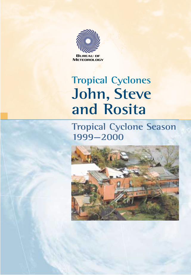
John, Steve and Rosita Tropical Cyclone Season1999—2000
BofMet-Cyclones 99/00 pamphlet 19/9/00 4:24 PM Page 1
Tropical Cyclones John, Steve and RositaTropical Cyclone Season 1999–2000
© Commonwealth of Australia, August 2000.This work is copyright. Apart from any use as permitted under theCopyright Act 1968, no part may be reproduced by any process withoutprior written permission from the Bureau of Meteorology.
Department of the Environment and Heritage
All satellite images from Japanese GeostationaryMeteorological Satellite. Whim Creek Hotel: Courtesy of WA Newspapers.
BofMet-Cyclones 99/00 pamphlet 19/9/00 4:24 PM Page 2
Tropical Cyclones John, Steve and Rosita 1
Tropical Cyclones
John, Steveand RositaTropical Cyclone Season1999—2000
The 1999/2000 tropical cyclone season was extremelyactive, with a total of eight tropical cyclones detected inwaters off northwest Australia (the waters between110°E and 129°E) compared to the average of four. Ofthe eight, three tropical cyclones that affected theAustralian mainland were unusual.
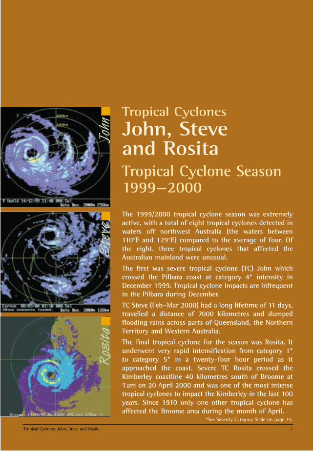
The first was severe tropical cyclone (TC) John whichcrossed the Pilbara coast at category 4* intensity inDecember 1999. Tropical cyclone impacts are infrequentin the Pilbara during December.
TC Steve (Feb–Mar 2000) had a long lifetime of 11 days,travelled a distance of 7000 kilometres and dumpedflooding rains across parts of Queensland, the NorthernTerritory and Western Australia.
The final tropical cyclone for the season was Rosita. Itunderwent very rapid intensification from category 1*to category 5* in a twenty-four hour period as itapproached the coast. Severe TC Rosita crossed theKimberley coastline 40 kilometres south of Broome at1am on 20 April 2000 and was one of the most intensetropical cyclones to impact the Kimberley in the last 100years. Since 1910 only one other tropical cyclone hasaffected the Broome area during the month of April.
Ros
ita
John
Ste
ve
*See Severity Category Scale on page 15.
BofMet-Cyclones 99/00 pamphlet 19/9/00 4:24 PM Page 1
2 Tropical Cyclones John, Steve and Rosita
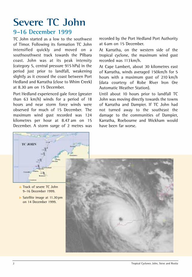
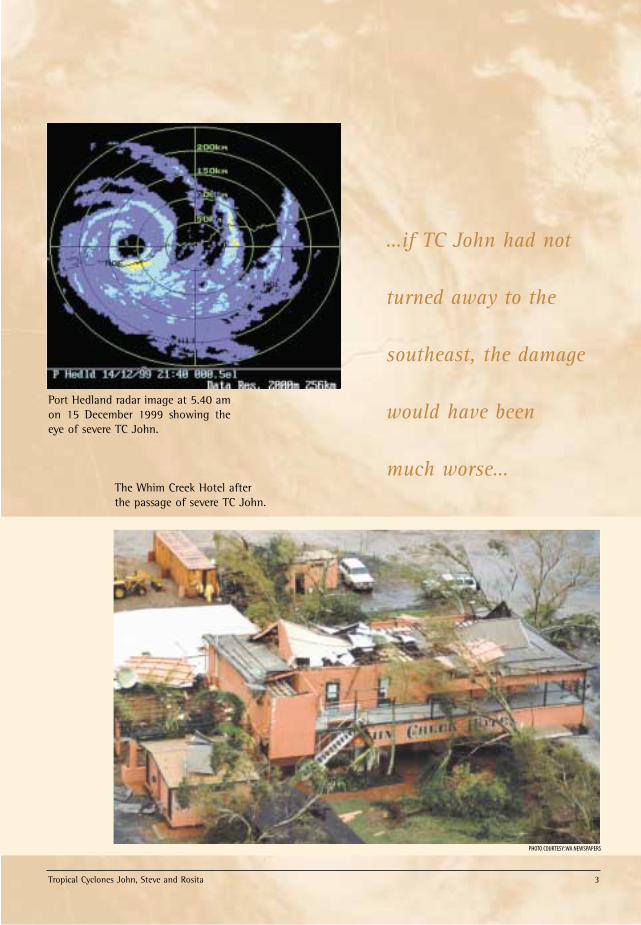
Severe TC John9–16 December 1999TC John started as a low to the southwestof Timor. Following its formation TC Johnintensified quickly and moved on asouthsouthwest track towards the Pilbaracoast. John was at its peak intensity(category 5, central pressure 915 hPa) in theperiod just prior to landfall, weakeningslightly as it crossed the coast between PortHedland and Karratha (close to Whim Creek)at 8.30 am on 15 December.
Port Hedland experienced gale force (greaterthan 63 km/h) winds for a period of 18hours and near storm force winds wereobserved for much of 15 December. Themaximum wind gust recorded was 124kilometres per hour at 8.47 am on 15December. A storm surge of 2 metres was
recorded by the Port Hedland Port Authorityat 6am on 15 December. At Karratha, on the western side of thetropical cyclone, the maximum wind gustrecorded was 113km/h. At Cape Lambert, about 30 kilometres eastof Karratha, winds averaged 150km/h for 5hours with a maximum gust of 210 km/h(data courtesy of Robe River Iron OreAutomatic Weather Station). Until about 10 hours prior to landfall TCJohn was moving directly towards the townsof Karratha and Dampier. If TC John hadnot turned away to the southeast thedamage to the communities of Dampier,Karratha, Roebourne and Wickham wouldhave been far worse.
Track of severe TC John9–16 December 1999.
Satellite image at 11.30 pmon 14 December 1999.
▲
▲
BofMet-Cyclones 99/00 pamphlet 19/9/00 4:24 PM Page 2
Tropical Cyclones John, Steve and Rosita 3
…if TC John had not
turned away to the
southeast, the damage
would have been
much worse…
PHOTO COURTESY:WA NEWSPAPERS
Port Hedland radar image at 5.40 amon 15 December 1999 showing theeye of severe TC John.
The Whim Creek Hotel afterthe passage of severe TC John.
BofMet-Cyclones 99/00 pamphlet 19/9/00 4:24 PM Page 3
4 Tropical Cyclones John, Steve and Rosita
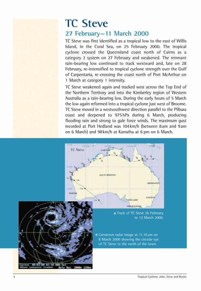
TC Steve 27 February—11 March 2000TC Steve was first identified as a tropical low to the east of WillisIsland, in the Coral Sea, on 25 February 2000. The tropicalcyclone crossed the Queensland coast north of Cairns as acategory 2 system on 27 February and weakened. The remnantrain-bearing low continued to track westward and, late on 28February, re-intensified to tropical cyclone strength over the Gulfof Carpentaria, re-crossing the coast north of Port McArthur on1 March at category 1 intensity.
TC Steve weakened again and tracked west across the Top End ofthe Northern Territory and into the Kimberley region of WesternAustralia as a rain-bearing low. During the early hours of 5 Marchthe low again reformed into a tropical cyclone just west of Broome.TC Steve moved in a westsouthwest direction parallel to the Pilbaracoast and deepened to 975hPa during 6 March, producingflooding rain and strong to gale force winds. The maximum gustrecorded at Port Hedland was 104km/h (between 8am and 9amon 6 March) and 98km/h at Karratha at 6 pm on 6 March.
Track of TC Steve 26 Februaryto 12 March 2000.
Carnarvon radar image at 11.10 am on8 March 2000 showing the circular eyeof TC Steve to the north of the town.
▲
▲
BofMet-Cyclones 99/00 pamphlet 19/9/00 4:24 PM Page 4
Tropical Cyclones John, Steve and Rosita 5
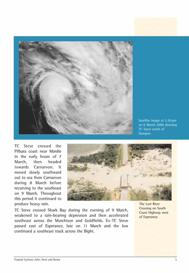
TC Steve crossed thePilbara coast near Mardiein the early hours of 7March, then headedtowards Carnarvon. Itmoved slowly southwardout to sea from Carnarvonduring 8 March beforerecurving to the southeaston 9 March. Throughoutthis period it continued toproduce heavy rain.
Satellite image at 5.30 pmon 6 March 2000 showingTC Steve north ofDampier.
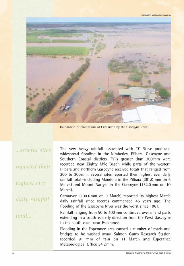
The Lort RiverCrossing on SouthCoast Highway westof Esperance.
TC Steve crossed Shark Bay during the evening of 9 March,weakened to a rain-bearing depression and then acceleratedsoutheast across the Murchison and Goldfields. Ex-TC Stevepassed east of Esperance, late on 11 March and the lowcontinued a southeast track across the Bight.
BofMet-Cyclones 99/00 pamphlet 19/9/00 4:24 PM Page 5
6 Tropical Cyclones John, Steve and Rosita
The very heavy rainfall associated with TC Steve producedwidespread flooding in the Kimberley, Pilbara, Gascoyne andSouthern Coastal districts. Falls greater than 300 mm wererecorded near Eighty Mile Beach while parts of the westernPilbara and northern Gascoyne received totals that ranged from200 to 300mm. Several sites reported their highest ever dailyrainfall total—including Mandora in the Pilbara (281.0 mm on 6March) and Mount Narryer in the Gascoyne (152.0 mm on 10March).
Carnarvon (100.6mm on 9 March) reported its highest Marchdaily rainfall since records commenced 45 years ago. Theflooding of the Gascoyne River was the worst since 1961.
Rainfall ranging from 50 to 100 mm continued over inland partsextending in a south-easterly direction from the West Gascoyneto the south coast near Esperance.
Flooding in the Esperance area caused a number of roads andbridges to be washed away. Salmon Gums Research Stationrecorded 91 mm of rain on 11 March and EsperanceMeteorological Office 54.2mm.
Inundation of plantations at Carnarvon by the Gascoyne River.
PHOTO COURTESY: WATER AND RIVERS COMMISSION
…several sites
reported their
highest ever
daily rainfall
total…
BofMet-Cyclones 99/00 pamphlet 19/9/00 4:24 PM Page 6
Tropical Cyclones John, Steve and Rosita 7
Contoured rainfall map for theweek ending 12 March 2000.
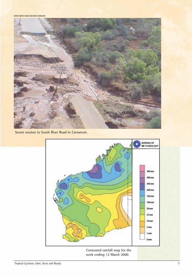
Severe erosion to South River Road in Carnarvon.
PHOTO COURTESY: WATER AND RIVERS COMMISSION
BofMet-Cyclones 99/00 pamphlet 19/9/00 4:24 PM Page 7
8 Tropical Cyclones John, Steve and Rosita
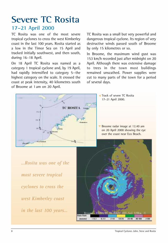
Severe TC Rosita 17–21 April 2000TC Rosita was one of the most severetropical cyclones to cross the west Kimberleycoast in the last 100 years. Rosita started asa low in the Timor Sea on 15 April andtracked initially southwest, and then south,during 16–18 April.
On 18 April TC Rosita was named as acategory 1 tropical cyclone and, by 19 April,had rapidly intensified to category 5—thehighest category on the scale. It crossed thecoast at peak intensity, 40 kilometres southof Broome at 1 am on 20 April.
TC Rosita was a small but very powerful anddangerous tropical cyclone. Its region of verydestructive winds passed south of Broomeby only 15 kilometres or so.
In Broome, the maximum wind gust was153 km/h recorded just after midnight on 20April. Although there was extensive damageto trees in the town most buildingsremained unscathed. Power supplies werecut to many parts of the town for a periodof several days.
…Rosita was one of the
most severe tropical
cyclones to cross the
west Kimberley coast
in the last 100 years…
Track of severe TC Rosita 17–21 April 2000.
Broome radar image at 12.40 amon 20 April 2000 showing the eyeover the coast near Eco Beach.
▲
▲
BofMet-Cyclones 99/00 pamphlet 19/9/00 4:24 PM Page 8
Tropical Cyclones John, Steve and Rosita 9
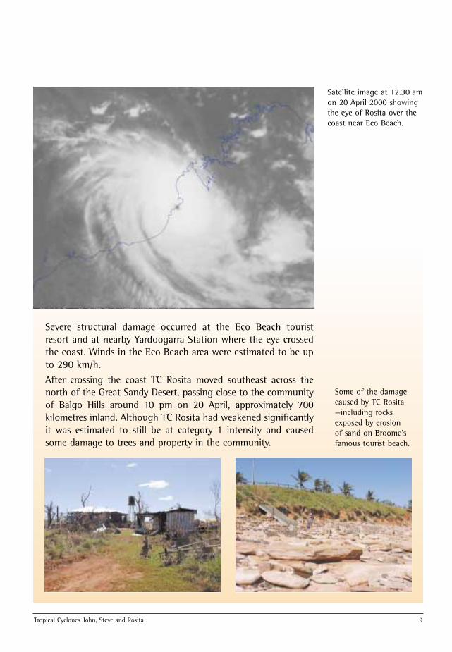
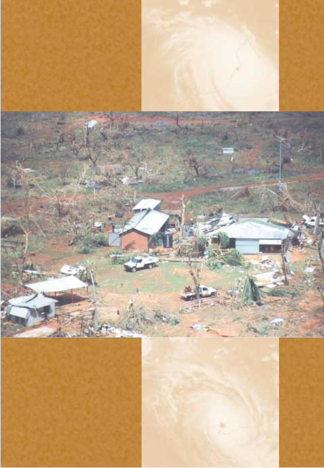
Severe structural damage occurred at the Eco Beach touristresort and at nearby Yardoogarra Station where the eye crossedthe coast. Winds in the Eco Beach area were estimated to be upto 290 km/h.
After crossing the coast TC Rosita moved southeast across thenorth of the Great Sandy Desert, passing close to the communityof Balgo Hills around 10 pm on 20 April, approximately 700kilometres inland. Although TC Rosita had weakened significantlyit was estimated to still be at category 1 intensity and causedsome damage to trees and property in the community.
Satellite image at 12.30 amon 20 April 2000 showingthe eye of Rosita over thecoast near Eco Beach.
Some of the damagecaused by TC Rosita—including rocksexposed by erosionof sand on Broome’sfamous tourist beach.
BofMet-Cyclones 99/00 pamphlet 19/9/00 4:24 PM Page 9
10 Tropical Cyclones John, Steve and Rosita
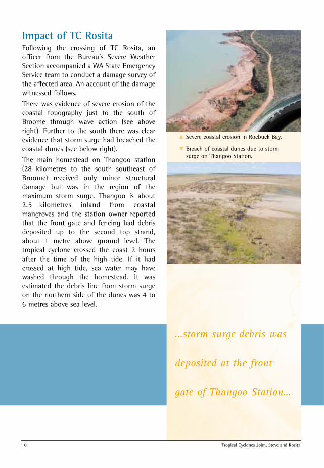
Impact of TC RositaFollowing the crossing of TC Rosita, anofficer from the Bureau’s Severe WeatherSection accompanied a WA State EmergencyService team to conduct a damage survey ofthe affected area. An account of the damagewitnessed follows.
There was evidence of severe erosion of thecoastal topography just to the south ofBroome through wave action (see aboveright). Further to the south there was clearevidence that storm surge had breached thecoastal dunes (see below right).
The main homestead on Thangoo station(28 kilometres to the south southeast ofBroome) received only minor structuraldamage but was in the region of themaximum storm surge. Thangoo is about2.5 kilometres inland from coastalmangroves and the station owner reportedthat the front gate and fencing had debrisdeposited up to the second top strand,about 1 metre above ground level. Thetropical cyclone crossed the coast 2 hoursafter the time of the high tide. If it hadcrossed at high tide, sea water may havewashed through the homestead. It wasestimated the debris line from storm surgeon the northern side of the dunes was 4 to6 metres above sea level.
Severe coastal erosion in Roebuck Bay.
Breach of coastal dunes due to stormsurge on Thangoo Station.
▲
▲
…storm surge debris was
deposited at the front
gate of Thangoo Station…
BofMet-Cyclones 99/00 pamphlet 19/9/00 4:24 PM Page 10
Tropical Cyclones John, Steve and Rosita 11
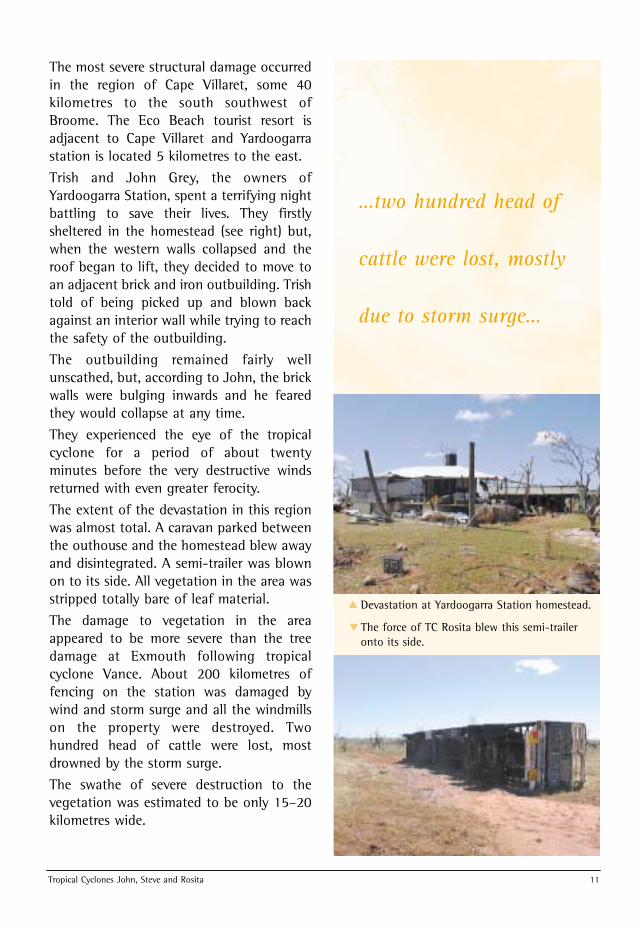
The most severe structural damage occurredin the region of Cape Villaret, some 40kilometres to the south southwest ofBroome. The Eco Beach tourist resort isadjacent to Cape Villaret and Yardoogarrastation is located 5 kilometres to the east.
Trish and John Grey, the owners ofYardoogarra Station, spent a terrifying nightbattling to save their lives. They firstlysheltered in the homestead (see right) but,when the western walls collapsed and theroof began to lift, they decided to move toan adjacent brick and iron outbuilding. Trishtold of being picked up and blown backagainst an interior wall while trying to reachthe safety of the outbuilding.
The outbuilding remained fairly wellunscathed, but, according to John, the brickwalls were bulging inwards and he fearedthey would collapse at any time.
They experienced the eye of the tropicalcyclone for a period of about twentyminutes before the very destructive windsreturned with even greater ferocity.
The extent of the devastation in this regionwas almost total. A caravan parked betweenthe outhouse and the homestead blew awayand disintegrated. A semi-trailer was blownon to its side. All vegetation in the area wasstripped totally bare of leaf material.
The damage to vegetation in the areaappeared to be more severe than the treedamage at Exmouth following tropicalcyclone Vance. About 200 kilometres offencing on the station was damaged bywind and storm surge and all the windmillson the property were destroyed. Twohundred head of cattle were lost, mostdrowned by the storm surge.
The swathe of severe destruction to thevegetation was estimated to be only 15–20kilometres wide.
Devastation at Yardoogarra Station homestead.
The force of TC Rosita blew this semi-traileronto its side.
▲
▲
…two hundred head of
cattle were lost, mostly
due to storm surge…
BofMet-Cyclones 99/00 pamphlet 19/9/00 4:24 PM Page 11
12 Tropical Cyclones John, Steve and Rosita
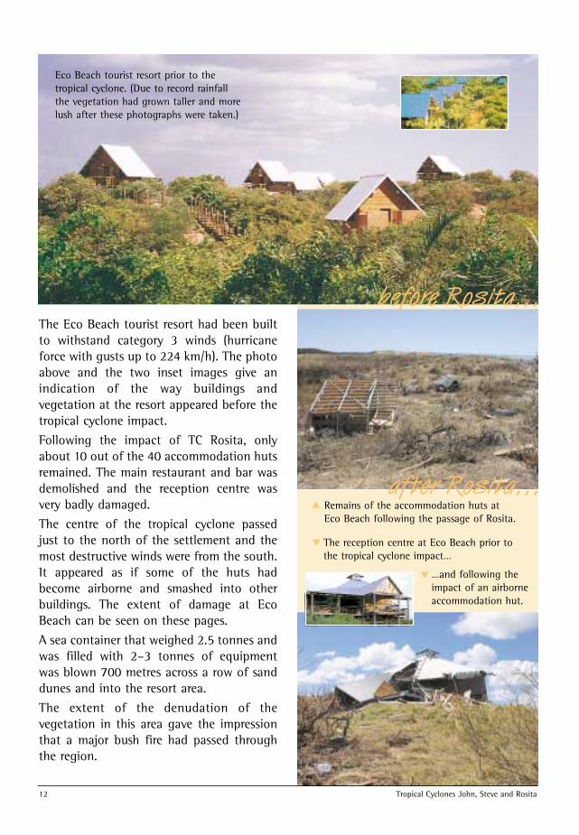
The Eco Beach tourist resort had been builtto withstand category 3 winds (hurricaneforce with gusts up to 224 km/h). The photoabove and the two inset images give anindication of the way buildings andvegetation at the resort appeared before thetropical cyclone impact.
Following the impact of TC Rosita, onlyabout 10 out of the 40 accommodation hutsremained. The main restaurant and bar wasdemolished and the reception centre wasvery badly damaged.
The centre of the tropical cyclone passedjust to the north of the settlement and themost destructive winds were from the south.It appeared as if some of the huts hadbecome airborne and smashed into otherbuildings. The extent of damage at EcoBeach can be seen on these pages.
A sea container that weighed 2.5 tonnes andwas filled with 2–3 tonnes of equipmentwas blown 700 metres across a row of sanddunes and into the resort area.
The extent of the denudation of thevegetation in this area gave the impressionthat a major bush fire had passed throughthe region.
Remains of the accommodation huts at Eco Beach following the passage of Rosita.
Eco Beach tourist resort prior to thetropical cyclone. (Due to record rainfallthe vegetation had grown taller and morelush after these photographs were taken.)
before Rosita…
after Rosita…
The reception centre at Eco Beach prior tothe tropical cyclone impact…
…and following theimpact of an airborneaccommodation hut.
▲
▲
▲
BofMet-Cyclones 99/00 pamphlet 19/9/00 4:25 PM Page 12
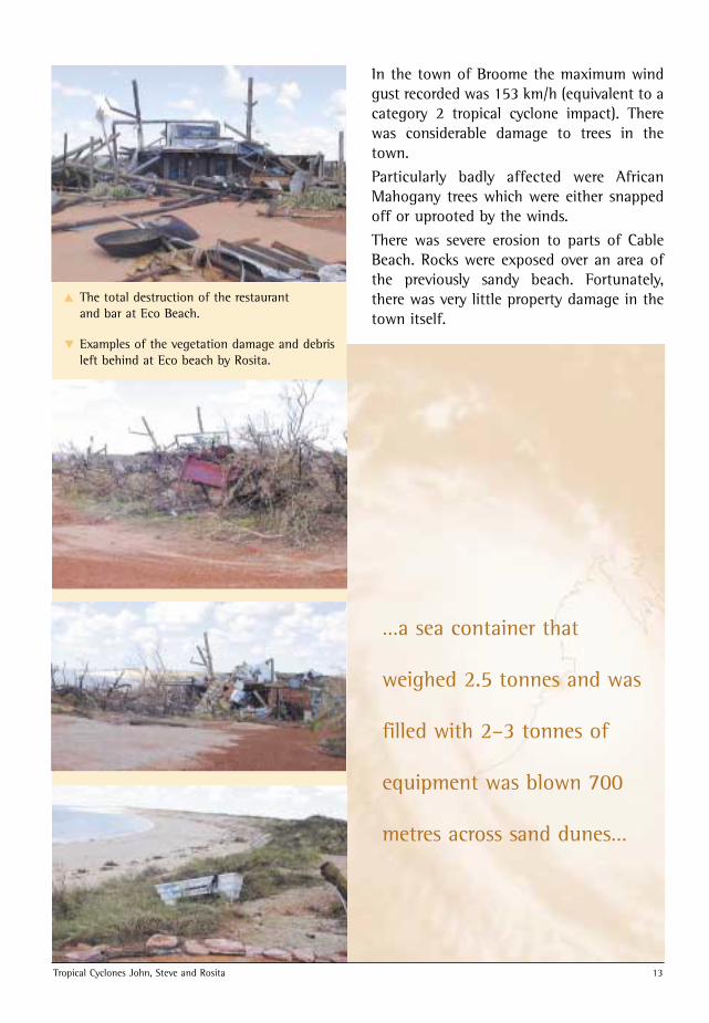
The total destruction of the restaurant and bar at Eco Beach.
Examples of the vegetation damage and debrisleft behind at Eco beach by Rosita.
Tropical Cyclones John, Steve and Rosita 13
In the town of Broome the maximum windgust recorded was 153 km/h (equivalent to acategory 2 tropical cyclone impact). Therewas considerable damage to trees in thetown.
Particularly badly affected were AfricanMahogany trees which were either snappedoff or uprooted by the winds.
There was severe erosion to parts of CableBeach. Rocks were exposed over an area ofthe previously sandy beach. Fortunately,there was very little property damage in thetown itself.
▲
▲
…a sea container that
weighed 2.5 tonnes and was
filled with 2–3 tonnes of
equipment was blown 700
metres across sand dunes…
BofMet-Cyclones 99/00 pamphlet 19/9/00 4:25 PM Page 13
14 Tropical Cyclones John, Steve and Rosita
The Australian Tropical CycloneWarning SystemImmediately it is recognised that a tropical cyclone mightendanger life or property of coastal or island communities within48 hours, the Bureau’s public warning system is activated. Thegeneral name given to tropical cyclone Watch and Warningmessages is an Advice or Tropical Cyclone Advice.
• A Tropical Cyclone Watch is issued if a tropical cyclone orpotential tropical cyclone exists and there are strongindications that winds above gale force will affect coastal orisland communities within 24 to 48 hours of issue. Watchmessages are updated every 6 hours.
• A Tropical Cyclone Warning is issued as soon as gales orstronger winds are expected to affect coastal or islandcommunities within 24 hours. Warnings are issued every 3hours. When a tropical cyclone is under radar surveillanceclose to the coast, hourly Advices may be issued. A TropicalCyclone Advice is prefixed “FLASH” when it is the firstwarning to a community not previously alerted by a tropicalcyclone watch or a significant change is made to theprevious warning.
Tropical CycloneThreat MapThe Tropical Cyclone ThreatMap is designed to visuallycomplement informationcontained in watch andwarning Advices. The threatmap shows the past track ofthe tropical cyclone and thearea of gale force winds(gusts>100km/h), destructivewinds (gusts>125 km/h) andvery destructive winds(gusts>170km/h).
BofMet-Cyclones 99/00 pamphlet 19/9/00 4:25 PM Page 14
Tropical Cyclones John, Steve and Rosita 15
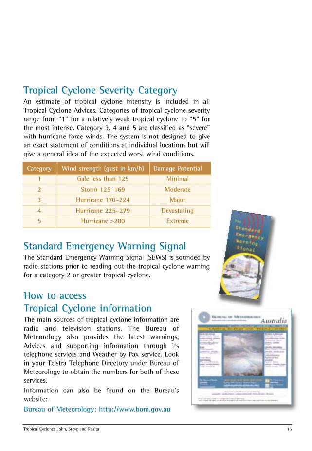
Tropical Cyclone Severity CategoryAn estimate of tropical cyclone intensity is included in allTropical Cyclone Advices. Categories of tropical cyclone severityrange from “1” for a relatively weak tropical cyclone to “5” forthe most intense. Category 3, 4 and 5 are classified as “severe”with hurricane force winds. The system is not designed to givean exact statement of conditions at individual locations but willgive a general idea of the expected worst wind conditions.
Category Wind strength (gust in km/h) Damage Potential
1 Gale less than 125 Minimal
2 Storm 125–169 Moderate
3 Hurricane 170–224 Major
4 Hurricane 225–279 Devastating
5 Hurricane >280 Extreme
Standard Emergency Warning SignalThe Standard Emergency Warning Signal (SEWS) is sounded byradio stations prior to reading out the tropical cyclone warningfor a category 2 or greater tropical cyclone.
How to access Tropical Cyclone informationThe main sources of tropical cyclone information areradio and television stations. The Bureau ofMeteorology also provides the latest warnings,Advices and supporting information through itstelephone services and Weather by Fax service. Lookin your Telstra Telephone Directory under Bureau ofMeteorology to obtain the numbers for both of theseservices. Information can also be found on the Bureau’swebsite:Bureau of Meteorology: http://www.bom.gov.au
BofMet-Cyclones 99/00 pamphlet 19/9/00 4:25 PM Page 15
16 Tropical Cyclones John, Steve and Rosita
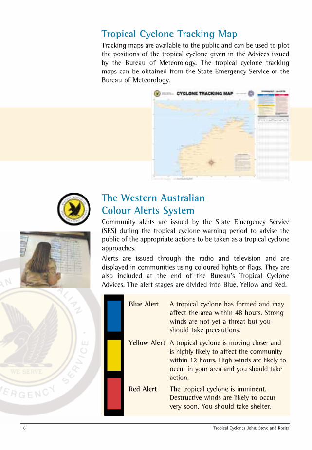
Blue Alert A tropical cyclone has formed and mayaffect the area within 48 hours. Strongwinds are not yet a threat but youshould take precautions.
Yellow Alert A tropical cyclone is moving closer andis highly likely to affect the communitywithin 12 hours. High winds are likely tooccur in your area and you should takeaction.
Red Alert The tropical cyclone is imminent.Destructive winds are likely to occurvery soon. You should take shelter.
The Western Australian Colour Alerts SystemCommunity alerts are issued by the State Emergency Service(SES) during the tropical cyclone warning period to advise thepublic of the appropriate actions to be taken as a tropical cycloneapproaches.
Alerts are issued through the radio and television and aredisplayed in communities using coloured lights or flags. They arealso included at the end of the Bureau’s Tropical CycloneAdvices. The alert stages are divided into Blue, Yellow and Red.
Tropical Cyclone Tracking MapTracking maps are available to the public and can be used to plotthe positions of the tropical cyclone given in the Advices issuedby the Bureau of Meteorology. The tropical cyclone trackingmaps can be obtained from the State Emergency Service or theBureau of Meteorology.
BofMet-Cyclones 99/00 pamphlet 19/9/00 4:25 PM Page 16
BofMet-Cyclones 99/00 pamphlet 19/9/00 4:25 PM Page 17
For further information on tropical cyclones in Western Australia, contact the:
Bureau of MeteorologyPO Box 1370West Perth 6872Tel: (08) 9263 2222
or the local Meteorological Offices at Broome, Port Hedland, Learmonth andCarnarvon.
Internet: http://www.bom.gov.au
For further information on tropical cyclones in Western Australia, contact the:
Bureau of MeteorologyPO Box 1370West Perth 6872Tel: (08) 9263 2222
or the local Meteorological Offices at Broome, Port Hedland, Learmonth andCarnarvon.
Internet: http://www.bom.gov.au
BofMet-Cyclones 99/00 pamphlet 19/9/00 4:25 PM Page 18