Trip to Yukon and Alaska - Sea and Sage Audubon · PDF file · 2017-09-02Trip to...
66
Trip to Yukon and Alaska Summer 2011 32 by Sylvia R. Gallagher Photographs by Jim & Sylvia Gallagher Part III 9:45 pm, Monday, June 20, 2011 Hi Country RV Park, Whitehorse, YK Yesterday, Sunday, June 19, there were low clouds and light to moderate rain all day. We had planned to stop en route at a lakeside RV park, but sitting in the trailer on a gloomy day didn't appeal to us, so we decided to proceed on to Whitehorse. The last 50 miles of the Cassiar were fairly slow with patches and frost heaves, but not really bad. (In fact, the entire Cassiar is a good road and nothing anyone should be hesitant about driving. Just be sure to get gas when it's available, for some stations were closed. Get information at the visitors center--one at either end--before taking the road.) When we got on the Alaska Hwy., however, we could really speed up. Except for a few curves and grades, it was a very good to excellent high-speed highway all the way. We got in around 4:30 pm and got almost the last sites (one left after us) in this RV Park, which is probably the nicest in town. We drove past a couple of others that looked pretty full, too. (Interestingly enough, tonight our RV Park must have still had 10-15% of its sites free when we came back from dinner in town around 9:00. Later we learned there had been an RV caravan in town the night before.) Today was a day of a multiplicity of errands and jobs. We did the laundry, got the oil changed, went shopping, and visited two museums. Donelda did some of the above, too, and also purchased some sealant and calked around the windows in her Airstream, which had been leaking pretty badly. (She's had lots of trouble with leaks of various sorts ever since she bought the trailer.) The first of the two museums was the Beringia Museum, which shows what life was like during the Ice Ages, when the ocean water was tied up in the Ice Sheets over much of northern North America and there was a land bridge to Siberia. Interestingly enough, much of Alaska and the Yukon was unglaciated and very hospitable to life. Some of the famous Pleistocene mammals roamed the grasslands (not the less nourishing tundra) then, including a giant beaver, the mastodon and woolly mammoth, the saber-toothed cat, a huge bear, etc. I've been reading the books listed earlier on the Arctic since we left home, so had learned a lot about what Canada was like when the ice sheets were coming and going. They indicate that the exact reason for the demise of all these species is still unclear. Was it human predation or habitat change caused by climate change or what? If either of these--or both--exactly how did it work? The museum was very well done, but Donelda and I agreed it was somewhat elementary after having read those rather technical books. I took lots of iPhone photos of the graphics in the museum and may use them if I ever do a program on this trip. The other museum was on the history of transportation in the north country. Of course, it started with the use of dogsleds, then proceeded to discussing how the Gold Rush people got their gear from down south to Dawson City, first on foot and then by the White Pass and Yukon RR, completed in 1900. North of Whitehorse there were the stern-wheeler boats on the Yukon (summer only) and horse-drawn, then Caterpillar tractor-drawn, sleds on the frozen river. Finally a road was built. The advent of the airplane caused temporary disuse of the
Transcript of Trip to Yukon and Alaska - Sea and Sage Audubon · PDF file · 2017-09-02Trip to...

Trip to Yukon and Alaska Summer 2011
32
by Sylvia R. Gallagher Photographs by Jim & Sylvia Gallagher
Part III
9:45 pm, Monday, June 20, 2011 Hi Country RV Park, Whitehorse, YK Yesterday, Sunday, June 19, there were low clouds and light to moderate rain all day. We had planned to stop en route at a lakeside RV park, but sitting in the trailer on a gloomy day didn't appeal to us, so we decided to proceed on to Whitehorse. The last 50 miles of the Cassiar were fairly slow with patches and frost heaves, but not really bad. (In fact, the entire Cassiar is a good road and nothing anyone should be hesitant about driving. Just be sure to get gas when it's available, for some stations were closed. Get information at the visitors center--one at either end--before taking the road.) When we got on the Alaska Hwy., however, we could really speed up. Except for a few curves and grades, it was a very good to excellent high-speed highway all the way. We got in around 4:30 pm and got almost the last sites (one left after us) in this RV Park, which is probably the nicest in town. We drove past a couple of others that looked pretty full, too. (Interestingly enough, tonight our RV Park must have still had 10-15% of its sites free when we came back from dinner in town around 9:00. Later we learned there had been an RV caravan in town the night before.) Today was a day of a multiplicity of errands and jobs. We did the laundry, got the oil changed, went shopping, and visited two museums. Donelda did some of the above, too, and also purchased some sealant and calked around the windows in her Airstream, which had been leaking pretty badly. (She's had lots of trouble with leaks of various sorts ever since she bought the trailer.) The first of the two museums was the Beringia Museum, which shows what life was like during the Ice Ages, when the ocean water was tied up in the Ice Sheets over much of northern North America and there was a land bridge to Siberia. Interestingly enough, much of Alaska and the Yukon was unglaciated and very hospitable to life. Some of the famous Pleistocene mammals roamed the grasslands (not the less nourishing tundra) then, including a giant beaver, the mastodon and woolly mammoth, the saber-toothed cat, a huge bear, etc. I've been reading the books listed earlier on the Arctic since we left home, so had learned a lot about what Canada was like when the ice sheets were coming and going. They indicate that the exact reason for the demise of all these species is still unclear. Was it human predation or habitat change caused by climate change or what? If either of these--or both--exactly how did it work? The museum was very well done, but Donelda and I agreed it was somewhat elementary after having read those rather technical books. I took lots of iPhone photos of the graphics in the museum and may use them if I ever do a program on this trip. The other museum was on the history of transportation in the north country. Of course, it started with the use of dogsleds, then proceeded to discussing how the Gold Rush people got their gear from down south to Dawson City, first on foot and then by the White Pass and Yukon RR, completed in 1900. North of Whitehorse there were the stern-wheeler boats on the Yukon (summer only) and horse-drawn, then Caterpillar tractor-drawn, sleds on the frozen river. Finally a road was built. The advent of the airplane caused temporary disuse of the

Trip to Yukon and Alaska Summer 2011
33
road. Then came the hurried building of the Alaska Highway during WW II. Donelda's father worked on the building of the Alaska Highway during that period. He was a heavy-equipment operator. We got finished so late that we decided to go out to dinner. After driving all over town looking for a place--and even walking into one that turned out to be too garlicky for me--we ended up in a nice little Chinese place downtown. It had only a few other customers, but I think they do most of their business with their lunchtime buffet. The food was pretty good, especially their ginger pork. All along the road starting on the northern part of the Cassiar we've been noticing a whitish cast to the aspen leaves. I thought for a while we had gotten into another species of deciduous tree, but when we got to Whitehorse and looked carefully at the leaves, we could see that they were covered with narrow brown lines <1 mm wide surrounded on both sides by a white deposit maybe 3 mm on each side. These wormy things are 4-6 cm long and curl all over the surface of the leaf, with several on each one. I took pictures.
Aspens infested with Aspen Serpentine Leafminer Whitehorse, YK
Close–up of aspen leaf with Aspen Serpentine Leafminer Whitehorse, YK

Trip to Yukon and Alaska Summer 2011
34
Donelda, who has Google access in her trailer, checked it out and discovered it is a huge infestation in this area of Aspen Serpentine Leafminer. It affects mainly Quaking Aspen, but to a lesser extent Balsam Poplar. This RV park is listed in Trailer Life as having WiFi, which means WiFi in the trailer sites. However, I found I could only get it inside and on the porch right outside of the main office building. It didn't even work around the shower building next to the office. This only fits TL's definition of "WiFi hotspot." 5:00 pm, Tuesday, June 21, 2011 Hi Country RV Park, Whitehorse, BC About the time we awoke this morning, it started to rain and kept it up until early afternoon. We decided we'd rather wait out a rainy day here where we had full hookups, especially electricity for our little heaters, than go on to a provincial park. Also, the scenery in the Kluane area is so spectacular, we didn't want to miss that by driving through it in the rain. I spent the morning getting my photo files organized--finally! I had so many loose ends--pictures dumped into the wrong folders or even into two of them, unidentified plants, unlabelled photos, etc. Around 3:00 we went to one more museum, the MacBride Museum of Yukon History downtown. Even though it is more of an old-fashioned museum with the displays kind of crowded, it really had more substance than the Beringia Museum we visited yesterday. However, it didn't particularly cover the ice age in this area, so one should go to both of them. The MacBride has mounted specimens of just about all the large mammals and many of the small ones--plus a few of the larger birds--of the territory, each one accompanied by a very interesting plaque telling a little about it. There was a lot on the history of the region, including interesting biographies of some of the more quirky characters who made their mark, including Robert Service. I learned that there really was a Dan McGee, but Service just used his name in his poem (with permission) and invented the story of his cremation. The real Dan McGee was just a respectable citizen of Whitehorse. There was another man who didn't want to be buried here after he died because of the cold. His remains now lie in Victoria, BC and he was not cremated on the shores of Lake LeBarge. Whitehorse got its name from the Whitehorse Rapids in Miles Canyon, which the 98ers had to run. They were located just upstream of the town and reminded people of the rearing heads of white horses. An artist did a painting depicting this, which I photographed. The painting was tucked away in a little alcove, so I had to take two iPhone shots and AutoStitch them together.

Trip to Yukon and Alaska Summer 2011
35
Painting: Whitehorse Rapids & imagined wild horses MacBride Museum of Yukon History, Whitehorse, YK
Now the rapids are part of a reservoir behind a dam. You can look at the canyon, but not the rapids. We all agreed that we enjoyed this museum more than the ones yesterday, even though the AAA didn't give it their "Gem" rating. 12:30 pm, Saturday, June 25, 2011 Oceanside RV Park, Haines, AK After spinning our wheels--figuratively and literally--for thousands of miles, we finally arrived at one of our prime destinations, where we hoped to find target birds, the Haines Highway. After much debate about whether to do Haines Highway before or after the Dempster, I lost and we did it first. It'll save us many miles, but force us to drive the notorious Top of the World, Boundary, and Taylor "highways" between Dawson City, YK, and Tok, AK. I've heard the road is in as bad or worse condition than when we drove it twenty years ago, but Jim and Donelda wanted to do it--Jim to save miles and Donelda for the adventure of it all. Oh, well, we'll see. Maybe it won't be that bad. Anyway, we left Whitehorse on Wed., June 27, and headed northwest on the Alaska Highway to Haines Junction. The road was good except for one smooth, but wet and muddy, ten-mile construction zone. Our vehicles are covered with mud at least half-way up. An interesting stop en route was a forest interpretive center, which showed how slowly the forest in this north country recovers after a fire. I photographed the sign and also the forest.

Trip to Yukon and Alaska Summer 2011
36
Forest 53 years after fire
Between Whitehorse and Haines Junction, YK
Here's the text:
"This burn area north of the Takhini River is evidence of one of almost a hundred fires that swept through the Yukon in 1958. A total of 6300 square kilometers (2500 square miles) of forest was burnt. Regrowth in the Yukon is always slow, but this area is taking an exceptionally long time to grow back. The forest is only now showing signs of slow regeneration. Scientists still debate whether the dry climate of the valley and the intense heat of the fire are enough to explain this slow recovery. In warmer southern regions you would be observing a new forest here by now instead of this aspen parkland. "Often presumed to be a destructive force, fire is in fact essential to the continued life of the forest. All Yukon forests have burned at one time or another. Seedlings spring up soon after a fire because sunlight is no longer blocked by trees and nitrogen is released by charred embers. Before long, wildlife that depends on fresh green shoots or leaves moves into these fire-scarred areas. Elk, moose, mule deer and snowshoe hare cal all be seen in this open valley."
The vegetation has been cleared far back from the road, no doubt as a fire break, but also to allow the driver to see any large mammal that might emerge from the woodland and not hit it. It also allowed us to see the stupendous panorama of the various Coast Ranges of mountains here in this bend in the North American continent. These mountains are still rising at the rate of 8-10 centimeters a decade. They're also being worn down by glacial and river action. Of course, they were entirely ice-clad during the ice ages, but today there are still lots of glaciers, as well as snow patches. The rivers are running full in the spring melt right now. The roadside clearings are full of wildflowers, and we saw large patches of a few of them, such as Beautiful Jacob's Ladder (Polemonium pulcherrimum), Small-flowered or Tall Penstemon (P. procerus), Heart-leaved Arnica (A. cordifolia), Showy and Late Yellow locoweeds (Oxytropis spendens and O. campestris). Donelda and I take photos of plants with our iPhone cameras, and I also photograph them with my film camera, especially in situations

Trip to Yukon and Alaska Summer 2011
37
where the iPhone camera prefers to focus on the ground or the foliage behind the subject and just won't focus on the close-up flower. (The iPhone book says you can tap on the screen where you want it to focus, and sometimes it works, but other times it just corrects the exposure, not the focus. It can be exasperating. However, when it does work, it takes amazingly nice photos for such a little thing.) After we get the pictures, we spend hours figuring out what each one is. Of course, whenever we can't find one, we stop at the bookstore in the next town and, ever hopeful, buy another flower book, which may or may not have the missing flower in it. Sometimes I think the flowers are in the books, but the images are just not that great. Oh, well. We're having fun, and it probably doesn't really matter if we misidentify a few, although we hate to do so. After a very good hamburger at a roadside dairy cafe in Haines Junction, where we ate outside on the deck with a view of the mountains, we went to the visitors center to see if we could get some bird-finding information on the Haines Highway. One of the attendants was fairly knowledgeable and suggested a few places we should stop. We also inquired if it was OK to boondock at the roadside rests in the alpine zone. They said people do it all the time and they hadn't heard of anyone chasing them away. We had been going to stay at Million Dollar Falls SP, the last one before the first pass, Chilkat Pass (not to be confused with Chilkoot Pass near Skagway), but it turned out to be at a very low elevation and many of the birds we wanted to see are in the alpine. So we headed on up to a stop that was called "Haines Summit," even though we had passed an obviously higher spot a quarter of a mile before that. This was a wide parking lot, but the road and the lot had been cut into a steep area. To get off the road we'd have to scramble up or down a steep gravel slope. We recalled seeing a little green-and-white toilet building two or three miles back, and according to the list of interesting stops on the sheet we got at the visitors center, it sounded like Chuck Creek trailhead, which had been recommended for birds. It turned out that was correct. I didn't like the trail after about 100 yards, but the entire area on both sides of the road was pretty level with open shrubby willows of several species. I think there were also some alders, but I didn't work hard to find them. The parking area itself was well off the highway and we were able to find fairly level places to park. The open tundra and mountain peaks all around were spectacular and we loved it.
Chuck Creek trailhead parking area (boondock campsite) Near summit, Haines Hwy., BC

Trip to Yukon and Alaska Summer 2011
38
From Chuck Creek trailhead campsite Near summit, Haines Hwy., BC
We roamed around that area all afternoon that day and all morning the next and began to see little microhabitats, based on the fact that certain birds were only found in certain areas. We had no sooner left the parking lot where our trailers were when we were challenged by a pair of Semipalmated Plovers in full breeding plumage. They were obviously nesting on the gravel between the braided channels of the wide creek. Of course, they called all the time and, because they were so bold, were easy to photograph and record. Most widespread were the Golden-crowned Sparrows. Based on most field guides, I had always thought they were in moist, shrubby areas with scattered tees, but here they were in the shrubby alpine. Fortunately Kaufman's Lives of North American Birds lists both habitats. Anyway, these birds were singing away most of the time. This was the first time I'd heard their complete four-noted song. On the rare occasions I've heard them in California in the winter, their songs have been incomplete--three notes at most--and that is what I put on my Learning More California Bird Sounds CD. I'd love to include a piece of this complete song on my Learning Western Mountain Bird Sounds CD, but it'd be a stretch, for the southernmost breeding range of this species is in the northern Cascades. [Later: I figured out an excuse to put it on anyway.] There were a few wildflowers in bloom here and there. I photographed these three, plus another that I was unable to identify: Frigid Shooting Star, Dodecatheon frigidum Mountain Avens, Dryas sp. Arctic Lupine, Lupinus arcticus

Trip to Yukon and Alaska Summer 2011
39
Arctic Lupine, Lupinus arcticus
Chuck Creek trailhead area, near Haines Hwy. Summit, BC I was fascinated by the lupine buds' adaptations to the cold: succulent and bristling with insulating "hairs." The next morning Donelda explored across the highway from where we were camped and began hearing and recording a thrush-like song, but not any thrush she knew. After comparing the song with those on Sibley (that handy iPhone app again), she identified it as a Gray-cheeked. I think she got a few distant photos of the bird, but it was very secretive. I never did see one well, but got some fine recordings. It's noted for keeping to the understory--feeding and nesting on the ground in dense thickets, and that's what these were: far too dense to wander through. We did not find it in the more sparse habitat. After recording the thrush until I was satisfied, I wandered along the cleared roadside for some distance up toward the pass. The willows became smaller and somewhat more scattered and the ground became more spongy and wet. As all good birders do when things slow down, I pished. Some distance away a bird popped up to the top of the tallest willow (not very tall here, maybe six feet) and began to sing a jerky, rollicking song. I recorded it and played it back. The bird came closer and I could see it had a rusty cap. My first thought was Green-tailed Towhee based on this field mark and the song. But this bird had a black breast spot and, besides, Green-tailed Towhees don't occur this far north. It was an American Tree Sparrow. The fact that this bird came in to playback made me hope Jim could get a picture of it, so I called him on my radio. Unfortunately by the time he got there, the bird was all out of

Trip to Yukon and Alaska Summer 2011
40
the mood to respond to pishing or playback of either Sibley's or my recordings. Donelda got there before Jim did and I think she got a few photos. In all areas where we wandered, we'd occasionally hear a silly, varied cackling sound. My first thought was, "It's a chicken," but of course it couldn't be. Then I realized it might be a ptarmigan. Later she found one, which apparently had a nest nearby, for it stuck around for her to photograph it. She was even able to take Jim to it and he also got photos. [Later: He got better ones later in the summer.] Another widespread species was a flock of little finches with forked tails. Donelda was able to spot the red cap of one, so we knew they were Common Redpolls. I never saw the red caps, but saw enough other features to concur. Their calls/songs were varied and obviously finchy. They sounded like a cross between a Lesser Goldfinch and a Pine Siskin, but with motifs of their own. We were disappointed not to find two birds on our target list--Smith's Longspur and the Timberline form of Brewer's Sparrow, which may be a separate species. We surmised that we'd have to find more open tundra to get those. So late in the afternoon of our second day we took a drive up through the Chilkat Pass area, stopping frequently to listen for those birds. Most of the roadside habitat was either dense willows or the other extreme, lichen-covered barrens or scree. Since we were driving and had to be sure we had enough gas to get to Haines, we turned back after a few miles. On the way back, we spotted two Grizzly Bears munching on vegetation in the ditch well below the left side of the road. One of them was a bit back in the willows, but the larger one (male or parent?) stayed in the ditch and paid no attention to us for a long time. He (we think) even let Jim back up the truck and pull over onto the left shoulder so he and Donelda could get even closer pictures.
Grizzly Bear Near Haines Hwy. Summit, BC

Trip to Yukon and Alaska Summer 2011
41
We drove a bit farther back and decided to stop for Donelda to get some distant shots of a Mew Gull that was nesting on a little island in a roadside pond. (The pond was, of course, of glacial origin and the island was the remains of a recessional moraine.) Before we knew it, she had skipped down the 45-degree roadside slope and was approaching the nest. Alarmed, the gull flew towards her, then flew off. I told her to pretend she was afraid and the bird would come back and maybe she could get some flight shots. This method has worked for us with terns and it proved to be a good tactic with gulls, too. Usually I do the "cringing" and Jim does the photographing, but she had to do it all herself because even Jim wouldn't scramble down that steep slope; of course, I wouldn't. Even so, she did get one pretty nice shot. There was also an Arctic Tern on a nest in the same area, but I don't think it gave her an opportunity for photos. Other sparrows in the area were Savannah, Lincoln's, and Sooty Fox (moderately dark). Other birds included Black-billed Magpie, Wilson's (abundant) and Yellow (a few) warblers, Hermit Thrush (a few, many more a bit lower in the subalpine), Trumpeter Swan (pairs on several different ponds), Common Loon (pair on one pond some distance south) and a scaup species. Other mammals included Arctic Ground Squirrel (many) and an Arctic Fox. The latter came out of the willows growing in a dry creek bed and caught sight of a ground squirrel and started to chase it. It came to about twenty feet from me before it caught sight of me standing motionless watching it with my microphone aimed at it. Then it quickly veered off and crashed away into the willows. All I have on my tape is that sound; I can't remember why I had the microphone on. Yesterday, Friday, June 24, we drove the remaining 62 miles to Haines, stopping many times en route for photos. The weather cooperated perfectly all three days we were on the Haines Hwy.--nearly clear skies and no wind except a little breeze late in the day. As we drove that wonderful road, range after range of glacier-clad mountains came into view. Each view was more stupendous than the one before. Sometimes the foreground was alpine tundra and later on it was subalpine with Mountain Hemlock and Subalpine Fir.
Subalpine habitat Haines Hwy., BC

Trip to Yukon and Alaska Summer 2011
42
Once Donelda caught sight of a pair of Trumpeter Swans on a pond and stopped to photograph them. As soon as she crossed the road to the pond, a Common Loon started calling, startled by her perhaps. We were ahead of her, so after dashing into the trailer and grabbing my recording gear, I had to walk back to where she was, but I still got some recordings from a distance. The Haines Highway is a wonderful road with almost no traffic. We found just a few frost heaves where it runs right along the Klehini and Chilkat rivers as it approaches Haines. Despite all the mountains on all sides, it has no steep places or sharp curves and the shoulders are broad enough that you can stop just about anywhere--again except for that last part, which was in Alaska, not Canada. There are also lots of broad pullouts. It's an ideal wildlife-watching road. The road itself follows the route of the old Tlingit Indian trail. The Indians kept the Americans and Canadians out of the interior for many decades in the 19th century, but the gold rushes around 1900 were too much for them. Signs along the road, which I photographed, document the progression from Indian trail to modern highway. The road starts out in the Yukon on the flatlands in the north, then the high country is in British Columbia, and finally the coastal zone is in Alaska. Our roadside-rest, alpine campsite was in BC and part of Tatshenshini-Alsek Provincial Park. We needn't have been worried about camping illegally, for while we were there a couple of park rangers, First Nations men, came by and chatted with us for a while. They were quite knowledgeable about many of the birds and told us where we could find nesting Wandering Tattlers, "only" nine kilometers up the Chuck Creek trail. They didn't know about Smith's Longspurs or Timberline Sparrows, but did tell us how to get to the kind of tundra we thought they'd be in--again many kilometers from the road. We could tell that they'd wandered all over that back country. It was interesting that they thought in terms of landmarks one would see while hiking cross-country. When I tried to get them to point out where they were talking about on a map, they were vague about it. Different thinking. Haines, Alaska, is declining in population and we saw many boarded up buildings and empty houses. It disincorporated about ten years ago and now there is a single government for the town and it environs, an entity called a borough and comparable to a county in most states. All of southeastern Alaska is declining in population, but Haines is declining the most. There are three RV parks in town, but one gets poor reviews in one book and is not listed in TL any more; that's where we stayed last time and my diary from that trip indicates that the electricity was undependable. The larger of the two recommended parks is a mile or so from downtown and we came to it on our way into town. It's nice and neat and is probably the nicest one. It has grassy sites, some of which back up to a row of trees. They seem fairly spacious. We decided to head for Oceanside RV park, which is reached by driving Main St. to where it ends at Front St. and turning left for half a block. It's on the right in a narrow strip between the street and the shoreline. All the sites are back-ins and very narrow, so the rigs are very close together. We had an awful time getting close to the boundary line (a black strip on the fence at the rear), but not over the edge. The inept guidance of the management plus Jim's lack of understanding of exactly where we were supposed to park didn't help, but we finally got in place. Since the trailers are all in a row, we had a nice view of the water out our front window and when we placed our truck a bit to the side of it, it was quite nice.

Trip to Yukon and Alaska Summer 2011
43
Beach and harbor from RV park Haines, AK
It certainly has more character than the one up the road. Across from the trailers are several picnic tables, spaced all along the edge of the drop-off to the rocky shoreline. Both evenings while we were there a group of campers who were more sociable than we got together and built a campfire near one of those tables and gabbed and sang until 10:00, when quiet hours started. The first night we got there, the management hosted a crab-feed potluck. Since we didn't have anything to bring to a pot-luck, we just ordered a cooked crab ($6.00) and brought it back to the trailer and ate it along with some other items that I fixed. It was delicious--and I got to eat most of it because Jim deemed it more trouble than it was worth to crack it. After I'd eaten my fill, I cracked the rest and saved it for lunch the next day. Today, Saturday, June 25, was a very different day. Donelda and Jim took a little water taxi over to Skagway from Haines, then rode the White Pass and Yukon Railroad train up to the pass and back, hung around in Skagway for three hours, partly spent eating lunch and then dessert, then took the taxi back here. They were gone from 6 am until 3 pm. I had taken the train trip on a couple of trips with Mother many years ago, so wasn't interested in repeating the trip. Besides, someone had to stay here and dog-sit. I've spent the day getting caught up on my photo labeling and my diary-writing. They were impressed by the train itself, but Jim was disappointed that it was difficult to convey the experience in photos. Without getting off the train, you really couldn't see what a narrow ledge it runs on or how steep the grade is. Skagway was a big turn-off--incredibly touristy and overrun with the occupants of two huge cruise ships that happened to be in port. Fortunately the restaurants weren't full. I guess the cruise passengers eat their fill on their ships.

Trip to Yukon and Alaska Summer 2011
44
I was especially glad we were camped where I could see the water during the day I stayed behind. Also, they could walk to the dock where their water taxi took off. Donelda walked up the hill to the downtown area, too. 5:30 pm, Sunday, June 26, 2011 Pine Lake Yukon Territorial Campground, nr. Haines Junction, YK This morning I awoke at 4:45, as I had done yesterday to fix Jim's breakfast before his boat ride. This time I got up and went out and recorded birds for an hour and a half before coming back to fix breakfast. Despite the fact that the Oceanside RV Park is close to the harbor and also to downtown, if I walked the other way on Front St., the houses were very sparse, with lots of tall Sitka Spruce trees and much tall roadside shrubbery and wildflowers like Cow Parsnip and Goatsbeard, all in full bloom. We had heard occasional Alder Flycatcher calls right across the street in back of the trailer. I heard it call just twice when I first went out, but it never called again while I was trying to record it. However, I did get my fill of calls of Northwestern Crows. What noisy, bold birds! They seemed to be following me up and down the street and calling to each other and yelling at me, too. Some of their calls are much like those of American Crows, but others seem rougher and in short fast bursts, rather than the usual extended caws of Americans. I'm aware that there is some thought that they shouldn't be considered a separate species. However, they are smaller than Americans, occur in the moist Pacific Northwest coastal belt, and have a different assortment of calls, so I doubt they'll lump them. I also got a few songs from Song Sparrow and Orange-crowned Warbler plus some "tik" calls of an agitated Lincoln's Sparrow. The houses along Front Street range from very nice to awful. A couple of newish looking ones were small, but very attractive. Another very old one was very large and looked like an ancient warehouse or fish processing plant converted to a house. The place was surrounded by junk and you could see it piled up inside to above the tops of some of the windows. Across the road from it was an ancient fishing boat that had obviously been moldering away for several decades. I took photos of one of the nice houses and also of the awful warehouse-like one. I think it's occupied by an old man, for the night before I had seen him sitting on the steps of the house when I walked Toby. I don't know if anyone else lives with him. We left Haines around 9:00 (Yukon Time, 8:00 Alaska Time) and drove back up the highway, making a few strategic stops along the way. The first was a revisit to the lake where we'd seen the Trumpeter Swans and heard the Common Loons on the way south. This time the swans were close to the road and Jim and Donelda were able to photograph them. They were calling, too, a sound that resembled the bark of a large dog, only a bit more resonant. I recorded that. We continued on to where the Mew Gulls and Arctic Terns were nesting down the steep roadside slope because Donelda wanted to try for more photos and also to get some recordings. This time a pair of Common Loons swam up and started their yodeling calls. As soon as I heard the first one, I dashed back into the trailer and aimed the mic out the window and got a lot of wonderful sound from not too far away. They did a wide variety of calls and continued for some time. Wonderful! Our final stop was an area in the vicinity of the Rock Glacier Nature Trail. The birder who works in the Visitors Center in Haines Junction had told me that Gyrfalcons are

Trip to Yukon and Alaska Summer 2011
45
sometimes seen flying over that area because the craggy mountain cliffs aren't very far away along that stretch of road. We ate lunch there and walked the nature trail a short distance, but saw no Gyrfalcon. The nature trail was pretty much devoid of birds, but of course it was mid-day. We could see the Rock Glacier from the start of the trail, so saw no reason to continue up to the toe of it. It's actually not a glacier, but rather the rocky debris left by an old one when it finally melted away. We got to Pine Lake Territorial Park around mid-afternoon and were able to get what I think are the only two sites with any view of the lake. It's out the back and through the trees, but there's a gravel trail along the lakeshore. A pair of Red-necked Grebes are nesting a considerable distance offshore in the emergent vegetation. We picked this place because Terry and John Hill stopped here for lunch in 2004 and found American Three-toed Woodpeckers in the picnic area. Why not give it a try? And that's what I should be doing right now instead of writing up this installment. When we drove by this place a few days ago on our way to Haines, we wondered why they called it Pine Lake, when all we could see along the road was spruce trees. When we explored the park, we found nothing but spruce trees. Obviously the lake was named by someone who was just like I was before I "discovered" trees a decade or so ago: "If it has needles and cones, it must be a pine tree." Of course, there are lots of other conifers, including spruce, fir, juniper, etc. 6:30 pm., Monday, June 27, 2011 Pine Lake Campground, nr. Haines Junction, YK After I wrote up yesterday's installment, I walked the nature trail that started in the day- use area and passed right behind our site and ran along the lakeshore. The most interesting place on the trail was what was termed a "thermokarst," a boggy pond with dying spruce trees tilted at various angles and fallen across one another into the pond in a tangle.
Thermokarst pond
Pine Lake Territorial Park, near Haines Junction, YK

Trip to Yukon and Alaska Summer 2011
46
The sign, also tilted at a crazy angle [and no longer there when we returned to the park in late summer], explained it: "This area is a permafrost environment, but because the water level of Pine Lake has risen, it seems as if the permafrost is melting as lake water conducts heat through the ground. When the permafrost melts, the water-soaked soil slumps and sinks. The effect has been creation of this 'thermokarst' pond. The eroding banks and toppling trees indicate that it is still growing." The sign didn't explain why Pine Lake is rising, and nowhere on the trail did it explain why there are no pine trees. We had intended to stay only one night here because it was pretty quiet in the late afternoon and evening. However, when we got up this morning to a glorious calm, clear day (the only clear day forecast for the next week) and heard birds singing, we began to change our minds. I spent an early morning hour or so in the day-use area and found some nice birds, but Donelda chose to walk the campground loop and went by the sites that were opposite the thermokarst along the nature trail. There she discovered an American Three-toed Woodpecker foraging and making occasional soft calls. That's the bird I stopped here for and we hoped we might find its nest. She also saw a crossbill, but I had to ask her if it might be a White-winged. She'd forgotten how simple it is to tell the two species apart. If it has white wingbars, it's a White-winged--and this bird had them. We discovered there was a campsite that backs up to the thermokarst and immediately moved the trailer over to it. I hadn't been watching it long when I discovered a Rusty Blackbird there, too. Three wonderful spruce-wetland birds! All are uncommon and hard to find. I wish I could tell you that Jim has photographed all of them, but despite sitting out there nearly all day, all he's gotten are robins and magpies. I did see the White-winged Crossbills a few times, including good looks at a male and an immature and an imperfect one of a female, but they were always pretty far away and in the treetops. I never saw or heard the woodpecker. Later in the day, Donelda encountered a ranger who knows birds and he told her the woodpeckers had nested right in the site we had vacated--but they had fledged May 10. Now they're just wandering all around. Donelda didn't realize how wonderful it was to find these birds, thinking they are easy to find. She grew up in northern Ontario with Rusty Blackbirds all around and wasn't aware that it is one of the fastest-declining birds in all of the northland, mainly because of all the clear-cut logging. Jim has gotten pictures of the White-winged Crossbill only once before (Newfoundland) and of the Three-toed Woodpecker once (Manning Park, southern BC). I have sounds of the crossbill, but only the sounds of nestlings of the woodpecker. He's never before seen or photographed a Rusty Blackbird. We'll hang around here in the morning until the "rush hour" of bird activity is over, then drive the 100 miles back to Whitehorse, where we'll do various mundane tasks before heading for the Dempster Highway. 5:30 am, Friday, July 1, 2011 Klondike R. Lodge, Klondike Hwy. x Dempster Hwy., YK On Tues., June 28, there was little activity of interest at Pine Lake in the morning, so we left fairly early and got into Whitehorse around 10:00. They wouldn't let us take a site right away in the Hi Country RV Park, where we stayed last time, so we towed the trailer around to do our errands at WalMart, the grocery store, and the propane place. Then we went back to the RV park, left the trailer and drove downtown to the Chinese place we had patronized in the evening on our earlier visit. They feature a noon buffet, so we made that our main meal and ate very little in the evening. The food is pretty good, but not excellent. My afternoon tasks

Trip to Yukon and Alaska Summer 2011
47
consisted of bathing Toby and defrosting the refrigerator, for which we needed EWS hookups. Wednesday and Thursday were days of driving the slow, frost-heaved, pot-holed Klondike Highway. Some stretches are pretty good, but you have to be forever on the watch for breaks in the pavement or rough repairs of same. Wednesday, June 29, it rained most of the time, sometimes lightly and sometimes fairly heavily. The clouds were low over the hilltops around us, so we really didn't get much out of the scenery. Donelda had her heart set on standing on the shores of Lake LeBerge, for she has fond childhood memories of her father reading Robert Service's poem to the family, especially The Cremation of Sam McGee. We weren't really sure how to do this because the lake was mostly a little distance away from the road and could only be seen from a distance. Our problem was solved indirectly when we caught sight of some attractive little signs advertising "Mom's Sourdough Bakery" a kilometer off on a side road. On a whim we took it, and found an exceedingly attractive, homey little establishment attached to the main house. "Mom" had a wide variety of breads, tarts, pies, sweet rolls, etc., all made from her own sourdough starter. We each bought a variety of items. So far we've eaten the huge cinnamon roll, which was enough for four pieces. It was a very light, sweet bread dough and very good. Jim had eaten his piece of rhubarb pie and said the filling was good, but the crust sort of hard. I have yet to slice the 12-grain bread loaf. When we were finished, we inquired how we were going to turn around our two trailers and were told to drive on another half-mile and we'd come to a park and campground, where there would be plenty of room to turn around. The park was on "the shores of Lake LeBerge," right where Donelda wanted to be. All she had to do was walk down the concrete boat-launching ramp and she was there. Even though it was drizzling pretty heavily at that time, we took pictures--and I shot a few of her standing there for her to put on her blog. They're not much as scenics, though, because of the depressing weather.
Lake Le Berge and Donelda
Near Klondike Hwy, YK

Trip to Yukon and Alaska Summer 2011
48
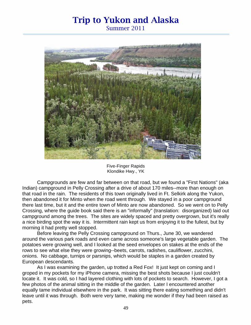
We ate the lunch special (cabbage rolls) at a hotel/gas station/restaurant complex in Carmacks. It was pretty good. Then we drove on to our other stop, the Five Finger Rapids overlook. This was an especially dangerous place for boat traffic on the Yukon in the early days, when the river was the major means of transportation. Four protruding rocks provide five narrow channels (fingers), one of which the boats squeezed through. The navigable channel had a cable along the edge, which the boats could attach themselves to--if they wanted to pay the $20 fee that the guy who had installed it charged. Many maneuvered it successfully on their own. Back in the 1930s a huge underwater boulder in the channel was blasted out, making the passage somewhat less treacherous. Today, the road from Whitehorse to Dawson has eliminated the need for commercial boats on the Yukon, so all the towns that served them are abandoned. The only traffic is the occasional adventurous tourist in a canoe. The rapids overlook is high above the river, but there is a set of 219 stairs (according to the sign, not our count) and a trail through the forest to a closer view of the area. Donelda had wanted to take it, but she twisted her knee the other day. She said the stairs were not a big problem, but the trail afterwards had lots of protruding roots that were difficult to step over without twisting her knee, so she turned back. I took lots of photos of the signs explaining the place.
Five-Finger Rapids – map on sign Klondike Hwy., UK
Trip to Yukon and Alaska Summer 2011
49
Five-Finger Rapids Klondike Hwy., YK
Campgrounds are few and far between on that road, but we found a "First Nations" (aka Indian) campground in Pelly Crossing after a drive of about 170 miles--more than enough on that road in the rain. The residents of this town originally lived in Ft. Selkirk along the Yukon, then abandoned it for Minto when the road went through. We stayed in a poor campground there last time, but it and the entire town of Minto are now abandoned. So we went on to Pelly Crossing, where the guide book said there is an "informally" (translation: disorganized) laid out campground among the trees. The sites are widely spaced and pretty overgrown, but it's really a nice birding spot the way it is. Intermittent rain kept us from enjoying it to the fullest, but by morning it had pretty well stopped. Before leaving the Pelly Crossing campground on Thurs., June 30, we wandered around the various park roads and even came across someone's large vegetable garden. The potatoes were growing well, and I looked at the seed envelopes on stakes at the ends of the rows to see what else they were growing--beets, carrots, radishes, cauliflower, zucchini, onions. No cabbage, turnips or parsnips, which would be staples in a garden created by European descendants. As I was examining the garden, up trotted a Red Fox! It just kept on coming and I groped in my pockets for my iPhone camera, missing the best shots because I just couldn't locate it. It was cold, so I had layered clothing with lots of pockets to search. However, I got a few photos of the animal sitting in the middle of the garden. Later I encountered another equally tame individual elsewhere in the park. It was sitting there eating something and didn't leave until it was through. Both were very tame, making me wonder if they had been raised as pets.

Trip to Yukon and Alaska Summer 2011
50
Red Fox (eating)
Pelly Crossing, YK
I did a little recording, including a cheerful, jerky song that might have been a Fox Sparrow. Their songs sound a little different up here. I did get a glimpse of the singer once, and it was about the right size and coloration for a Fox Sparrow. How I'd love for Jim to get photos of this western race of the Red Fox Sparrow (zaboria). We had been planning to drive to the Tombstone Campground fifty miles up the Dempster from the junction, but our late start and the slow road made us decide to settle for the junction RV Park, Klamath River Lodge, a drive of about 130 miles. En route we made a couple of stops at interesting places with interpretive signs. Both are along the Tintina Trench, termed the biggest geologic fault valley in North America. The first place was called Gravel Lake, a lake covered with water lilies and breeding home to a number of birds. I spotted Lesser Scaup, Surf Scoter, Bufflehead, and Red-necked Grebe, but the signs said far more travel the trench during spring and fall migration. There were a number of land birds there, too, and Donelda even got a glimpse of a small flock of Bohemian Waxwings, but they didn't hang around long. We tried to bring them back by playing a recording, but to no avail.

Trip to Yukon and Alaska Summer 2011
51
Somewhat farther along we found a high overlook of the Tintina Trench valley and signs explaining it more fully. It's a strike-slip fault which runs diagonally from southeast to northwest, with the southwestern side moving north with respect to the northeastern one--sort of like our San Andreas. Today major river systems, including the Yukon and the Klondike, flow along this fault. The gold in this area was all concentrated and churned to the surface by geologic action along this fault. Wonderfully informative signs and maps at the overlook explained in detail how seismic action and ice dams during the Pleistocene have dramatically changed the course of rivers in the area. I took photos of all the signs.
Tintina Trench From Klondike Hwy., YK
We got into our campground around 3:00. The place consists of a motel, gas station, restaurant, and small RV Park. Some of the sites have EW hookups, and there is a dump station. The latter was all clogged up with icky water standing in the concrete enclosure above where it was supposed to drain. We knew this was the last dump before Inuvik and we plan to spend quite a few days driving the Dempster. They tried to clear the clog, but Jim finally ended up carrying our black water in bucketfuls to the pipe beside the station and pouring it into that. Fortunately it has a pretty large diameter, but it was still a messy task. We'll just carry our gray water along and dump it beside the road somewhere. There's no other dump station before Inuvik--not even at Eagle Plains, so we had to get our black tank empty. Not too many birds here. However, I've been watching a juvenile White-crowned Sparrow harvesting dandelion seeds and ignoring Jim's feeding log. Also present are Chipping Sparrows, which haven't discovered the feeding log either. We had a little rain yesterday and a bit more before we got up this morning. Right now it's mostly cloudy. Forecast is for intermittent rain for the foreseeable future. The residents up here are really complaining about the lack of warm, sunny, summer weather. They have such long, cold winters, you can understand their displeasure.

Trip to Yukon and Alaska Summer 2011
52
10:30 pm, Friday, July 1, 2011 Tombstone Mountain Cpgd., Dempster Hwy., YK It's still broad daylight as I sit here writing up today's activities. We drove the fifty or so miles north from the junction to Tombstone Mountain Campground and were overjoyed to find the site we liked so much last time to be free. We got here at noon, but today is Dominion Day, a Canadian holiday much like our July 4. Fortunately there aren't a lot of people in this area to take holidays in this park. Most of the visitors are undoubtedly from far away, so weekends don't matter. This site was special for us last time because of the Merlins that had their nest right in the site. The nest site in the tree is now pretty tangled with foliage, so I suspect it's no longer used. However, I have heard Merlin calls in the campground a couple of times since we got here. I'll have to find out where their new home is--or, rather, that of their followers (descendants?). We drove the road slowly, but the habitat in this first part isn't much different from the boreal forest we've been in since far south of here on the southern Cassiar Hwy. in BC. Since we were here last time, a huge patch of the Ogilvie Mountains, including the campground, have been made into a Territorial Park and a large new visitors center has been built. When we were here before, there was just an old brown building in the front end of the campground. (It's still here.) After lunch we drove over to the Visitors Center, looked at all the informative displays, and talked with the staff at the desk about where to find a few of the birds we especially want to see, notably Northern Wheatear, Smith's Longspur, and Gyrfalcon. I was extremely disappointed to learn that, just as when we were here in 1991, the falcon isn't nesting in Windy Pass this year, so we'll be lucky to see one. That's been my jinx bird. (Donelda even saw one as we were driving the Haines Hwy., but I missed it.) The young lady who helped us at the desk turned out to be Sylvia Frish, daughter of the long-deceased Robert Frish, who wrote the book, Birds by the Dempster, which awakened the birding world to the potential of this highway. She is a very knowledgeable birder, too. I mentioned that we had been up the road 20 years ago and I had left a copy of our bird list with her mother when we returned, because she asked for it and hoped to revise her husband's book. Lo and behold, the other person at the desk turned out to be her mother. She asked me my name and said she remembered me and still had my list in her files. Amazing. I spent the rest of the afternoon looking over all the literature we picked up and purchased at the center. This evening after dinner Donelda and I attended a wildflower program in the campground. It was excellent and far more informative than the usual campfire program in a US national park. It turned out that this weekend is Botany Weekend here in the park and they've developed a comprehensive schedule of hikes and talks. A dozen or so botanists from all over Yukon and maybe Alaska, some exceedingly competent, were present. It reminded me of a mini-WFO meeting (WFO = Western Field Ornithologists), a delightful mix of professionals and serious amateurs. The woman who gave the program had a few copies of the list of flowers she was showing and I was lucky enough to get one. I took notes on which ones are in bloom now and where to find them. Donelda is all ready to take a tundra hike tomorrow afternoon and a workshop on how to identify the 30-odd species of Yukon willows on Sunday morning. I don't think my physical skills are up to the hike, nor my interest level up to the willow workshop, but we'll be happy to do other things while she attends those. I do intend to go to tomorrow night's program on the rare plants of Yukon. The young man

Trip to Yukon and Alaska Summer 2011
53
who will be presenting it was there tonight and he contributed a lot to the discussion and had a delightful personality. He's also doing the willow workshop, so it should be good, too. Anyway, we already feel right at home here on the Dempster, the place I have such fond memories of from twenty years ago. I just had to write this up while it was fresh in my mind--even if my mind isn't really too fresh at almost 11:00 pm. (Of course, it's still broad daylight.) 5:15 pm, Sunday, July 3, 2011 Tombstone Mtn. Campground Yesterday morning, Sat., July 2, we took a drive north a ways on the highway, using Donelda's truck. She has a range of 500-600 miles, while ours is more like 300 miles, so we don't dare do any driving back and forth if we're going to make it to Eagle Plains, the half-way point where there is a gas station. We stopped a couple of places and photographed the spectacular scenery, accented by dramatic cloud formations. Tombstone Mountain itself (20 km away) was shrouded in clouds. The campground is located exactly where the boreal forest ends and the tundra begins, so we were in tundra as soon as we started north from there. We headed for a gravel pit known locally, but not labeled, as Honeymoon Pit for reasons that were not explained. It's a place known for a variety of unusual wildflowers, but I didn't see very many. Donelda headed up the trail where they were and I didn't follow her because her dangling camera and parabolic microphone make a clatter whenever she moves. However, I did succeed in recording some interesting sounds. When I played one of my pieces back, a male Common Redpoll came in and gave me a nice close look for a few seconds, but the song didn't really sound like that bird. However, I called Jim to come over and see if I could get it up again. When I played it again, either a Fox Sparrow or an American Tree Sparrow gave us a few fly-bys, but I couldn't really see which it was. Jim took one awful picture, which is probably an American Tree Sparrow. The song is really too simple for either of these, too, so I'm still baffled. When I get home and can analyze the recording using Raven, maybe I can figure it out. [Later: When editing this, I looked it up in my notes on my recordings and couldn't even figure out which sound I was puzzled about, but had nothing very good that day.] We continued on to the area around the outfitters camp (a few red buildings and pens
for horses). Across the road from the camp is some rather sparse tundra, which Sylvia Frish had told us is a good place for Smith's Longspurs. We did hear one sing once off in the distance. I had my mic on or I wouldn't have heard it, but was not recording at the time. By that time Donelda had walked out onto the tundra between me and where the bird was, so I had no hope of hearing it any better--and certainly no hope of seeing it. I walked farther up the road, hoping for another bird, but the tundra became much more lush and inappropriate for that bird.
Highway through Blackstone Uplands, Dempster Hwy., YK

Trip to Yukon and Alaska Summer 2011
54
A bit later I recorded a series of low doublets from a puddly area in the ditch beside the road and thought it might be a frog. (There is a frog up here, the Wood Frog, which I have heard a recording of.) However, when I approached the area a bit, out burst a chicken-like bird with a loud series of alarm calls, which I also recorded. He only flew about 150 ft and settled down poorly concealed in a small willow. I was able to identify it as a male Willow Ptarmigan. Apparently only the male gives those frog-like sounds. [Later: After I got home, I discovered Jim had actually photographed both a male and a female.]
Willow Ptarmigan – female
Blackstone Uplands, Dempster Hwy., YK
Willow Ptarmigan – male Blackstone Uplands, Dempster Hwy., YK

Trip to Yukon and Alaska Summer 2011
55
A little farther along, I heard some sounds that reminded me of a curlew and wondered it if could be a Whimbrel, since I really don't remember what that sounds like. However, it turned out to be an American Golden-Plover. As I approached closer, but still 100 yd away, it went into a variety of other motifs. Since it was such a quiet place and day--just a little breeze--the recordings should be quite nice. We'll see. Donelda had to be back in time to eat lunch and go on the wildflower hike at 1:00, so we hurried back to our trailers. I was glad to quit anyway, for the day was quite cold and I was really chilled. Donelda likes to drive with her truck windows open to hear birds, although how she can hear them over the roar of her diesel engine is beyond me. She does have much better hearing than I do, though. By the time we got back to the trailer, I was thoroughly chilled and really shivering. After a lunch of hot soup, I settled down under two blankets for a nice nap and finally warmed up. In the evening there was a program by Bruce Bennett on the rare plants of Yukon. He is in charge of educating the public in Yukon about wildlife, can't recall his exact title. He creates educational materials and participates in educational programs like this "Botany Weekend" here at Tombstone. A more knowledgeable and personable man would be hard to imagine. Although I don't expect to ever see any of the plants he showed, his presentation was still fascinating. What lengths these Yukoners go to in order to locate these rare plants! Most of them seem to be on barrens or other disturbed places on the tops of steep mountains, with talus slopes that must be ascended in order to get there. Many of them are Saxifrages--tiny little things, but incredibly varied in shape and color. The materials he showed are all on the website of the Yukon Conservation Data Center, so that may be the name of his employer. Donelda had been on a hike in the afternoon with him. They walked across some wet tundra and then ascended to the top of a round-topped mountain in search of wildflowers. The habitat they were going to held promise of Northern Wheatears, so Donelda carried her camera just in case. It turned out, though, that while they were up there, a thunderstorm rolled in. We'd been having a lot of rain, but this was the first lightning in many days. The top of a mountain is not a good place to be in such a situation. At one point all of them had their hair standing on end, they were so close to the electrical action. Donelda said they could even see the lightning below them. A quick descent was in order and fortunately no one was the worse for the experience. This morning Donelda attended a workshop by Bruce Bennett on how to identify Yukon willows. I decided I really didn't want to know that much about them, but she said it was really interesting and felt it would help her with California ones. Bennett has developed a simple key to them and they used it on some specimens he'd collected here in the park. He told them that many people dismiss difficult willows as hybrids, when most actually can be identified to species. Hybrids are much more rare than people claim. He seemed to be an expert on all North American willows, she said. In promoting his workshop last night, he had told us that there are 45 species of willow in Yukon, more than anywhere else in Canada. This is about 10% of the species in the world. Some are trees, some shrubs, and others prostrate tundra-dwellers. I took a brief walk this morning, hoping to record some bird sounds, but it was cold and cloudy and very few birds were vocalizing. I did get a little bit from a Boreal Chickadee, but unfortunately it had a loud generator in the background. The sky gradually became more threatening, so I returned to the trailer and got there only about five minutes before the rain started. It's been raining moderately to lightly ever since. Donelda took a wildflower walk, which had been billed as an easy walk and sounded

Trip to Yukon and Alaska Summer 2011
56
like something I could do, but I decided against it because of the rain. Donelda told me it was actually harder walking than her hike of the day before, because they had to clamber over rocks. However, she was really glad she did it, for she saw her "life" Harlequin Duck and got to walk on aufeis. That is a thick coating of ice that forms on a river in the wintertime. The river doesn't freeze to the bottom, but the pressure cracks the ice and water comes up through the cracks and flows over the top, then freezes. This happens repeatedly. Aufeis is actually a German word meaning "on top of ice." I spent the day in the trailer listening to and analyzing in Raven a two-CD recording of birds of the Dempster Hwy by John Neville that Donelda bought. It's quite nice and should be helpful. It's sort of a travelogue of birding the Dempster and there's a companion book, which is recently off the press. They only had one copy of the book in the Visitors Center and they kindly lent it to Donelda for her to read and return to them when we come back down the highway. I suspect there'll be time for me to read it, too. They've ordered some to have on sale. There are one or two errors on the CDs. One is obvious: a Say's Phoebe misidentified as a Western Wood-Pewee. The stated habitat where the recording was made is not correct for the Wood-Pewee and perfect for the Phoebe. And the sound is obviously Say's Phoebe. The other possible error is a confusion between American Tree Sparrow and Fox Sparrow. I'm not sure enough of how to distinguish those two to tell if it truly is an error, but Sylvia Frish thought it was. I've been interested in the extra-strong Canadian accent of people here in Yukon. (They don't say "the Yukon," as I always have.) It sounds almost Scottish, and certainly many Canadians are of that ancestry. Pronunciations of words vary between the two countries. A pair of differences really amused me. At the Friday night lecture, someone made fun of the way Americans pronounce the word "cinquefoil." We say "sink-foil." They say "sank-fwah," a French pronunciation. On the other hand, last night, Bennett was referring to the "Cordillera," a Spanish word for the Rocky Mountain chain. Americans pronounce it the Spanish way, "cor-dih-YEHR-ah," but he said "cor-DILL-er-uh." It took a couple of repetitions of that pronunciation before I figured out what he was talking about. It's 6:30 now and really raining hard. Hope it gets it over with tonight so we'll have a nice day to drive farther north tomorrow. 8:00 pm, Monday, July 4, 2011 Beside the road at the top of Windy Pass, Dempster Hwy, YK Today didn't work out quite as we planned. I got up around 4:30 am to use the bathroom and, as I usually do, check on the temperature of the front part of the trailer. To my horror, as soon as I opened the door, I heard the refrigerator beeping and saw the "no flow" signal. We were out of propane. It's true that we've been doing a lot of space heating with propane because of the cold, rainy weather, but we've never run out of it this fast before. Jim went out to check to be sure both tanks were turned on, and they were. There was nothing to do but drive back to the Dempster Junction (100 miles round trip) for a refill. We had no heat and no way to cook breakfast, so we decided to set out as soon as we could. I went over and awakened Donelda--or maybe I awakened Oakley, who in turn awakened Donelda. We agreed that she would drive slowly up the road, birding all along and we'd catch up with her. If we didn't overtake her by 4:00 pm, she'd return to Tombstone Mtn. Cpgd. and wait for us. There's no phone service and in the cloudy weather we've been having,

Trip to Yukon and Alaska Summer 2011
57
even the satellite WiFi and phone at the Visitors Center isn't working. This far north, satellite dishes are aimed almost horizontal. Jim tore down the road, thinking the drive was 70 miles, when it was actually about 70 km or more like 50 miles. He recalled that the place at the junction opened at 7:00, but it turned out it didn't open until 7:30. When we got there, we filled our water tank (I took a shower tonight for the first time in several days, since we've been conserving the precious fluid. They recommend you boil the water in the campgrounds on the Dempster, so we certainly don't want any of it in our tank.) The gas pumps opened at 7:30 and so did the restaurant, but the cook didn't turn up and the guy who pumps the propane ran off to find out where she was. Breakfast was somewhat delayed. I think another person filled in for the missing cook, but I'm not sure. The breakfast was pretty poor, especially my egg, which was frizzled to a crisp. The hash browns were actually yesterday's warmed over home-fries with lots of pepper and onions--fine in the evening, but not for breakfast. Then came another problem. They couldn't get any propane into the empty tank and they discovered that the other tank was actually full! The problem was apparently a bad flow valve. A bystander said he'd had the same problem after having the same kind of valve as we did. If I understand the problem correctly, they could fill the tank if they switched the positions of the tanks. Jim thinks that when this tank is empty, he may be able to access the other tank by switching the tanks again, but isn't sure. We're hoping to be able to get a replacement valve in Inuvik, but who knows? Anyway we have 2 full tanks of propane, but may be able to use only one of them. We were relieved to discover in the process that we didn't use up two full tanks in only six days. Of course, we also filled our truck with gasoline before we left to drive back. It rained lightly most of the way back up the road and our trailer is an absolute muddy mess, partly because of that and partly because we drove so fast on the way down. It is literally impossible to see out of the rear windows and the side ones were almost as bad before Jim washed them with water from a little puddle. We caught up with Donelda at a place called Two Moose Lake. And what was she doing? Photographing two Moose, which were deep in the water in the middle of the lake harvesting pondweed. About 15-20 American Wigeons were swimming all around them taking advantage of what they stirred up. She had seen that scenario when she drove up the road with the hiking group a couple of days earlier, but said she had been there a couple of hours and the Moose had just entered the lake. Before that they had walked all around her trailer parked beside the road. She said she had driven up there very slowly, stopping and listening frequently for birds, but the cold drizzle really kept the bird activity at a minimum. Jim got a few pictures, but by then the action was out in the middle of the lake.

Trip to Yukon and Alaska Summer 2011
58
Moose and American Wigeons
Two-Moose Lake, Dempster Hwy., YK
We continued on northward, stopping occasionally to listen, too, but found nothing of interest, probably because it was cold and raining lightly most of the time. We were in the Blackstone Uplands, perhaps the richest place on the entire Dempster for breeding birds, making the day especially disappointing. Twenty years ago this place was wonderful. We were prepared to drive another 50 miles, but lucked out and found a wide pull-out at the top of Windy Pass, just three miles short of the steep cliffs where Gyrfalcons usually nest--but not this year and not in 1991 when we were here before. Still the birds might be around, so we'll spend a good bit of time looking for them when we pass by that area tomorrow. I recall that last time I walked the entire steep-cliffed area and maybe I'll do it again--if it doesn't rain! The rain quit in the late afternoon and the sun peeked out occasionally. But it was 50 ̊ and Windy Pass lived up to its name. The pass is on a broad slope with round-topped worn-down limestone mountains all around. (The scene is so expansive that I couldn't appreciate it until Jim walked up the slope and became a tiny speck in the distance.

Trip to Yukon and Alaska Summer 2011
59
Windy Pass (Jim in exact center of picture)
Dempster Hwy., YK One of them was the one Donelda climbed in the thunderstorm a couple of days ago, so of course we stopped a few places so she could photograph it. The habitat here at the top is pretty gravelly and barren and looks as though they've deliberately removed a lot of willows for reasons we can only speculate about, so I won't. Growing on the slope are a number of pretty wildflowers, though, including my favorite from our last trip, Bistort.

Trip to Yukon and Alaska Summer 2011
60
Bistort, Polygonum bistorta Windy Pass, Demptster Hwy., YK
I have one spike of it in the vase in front of me on the table. Jim picked it for me and brought it in, not knowing how much I like that one. (He hardly ever picks a flower for me without being requested to descend or ascend some steep slope to get it, so I was especially touched.)

Trip to Yukon and Alaska Summer 2011
61
5:30 pm, Wednesday, July 6, 2011 Eagle Plains Hotel Campground, Dempster Hwy, YK After a gruelling 108-mile drive on a rough dirt/gravel road, we reached the half-way point of the Dempster Highway. Some of the road was pretty good, but a lot of it was very rough with potholes and embedded stones, so it took us all day to get here. Of course, we stopped here and there for photos, etc. But let's take things in order: Since we only planned to drive about thirty miles yesterday, Tues., July 5, we got a late start from our boondocking campsite at the summit of Windy Pass. I fixed Jim some pancakes and then Donelda and I photographed a lot of wildflowers that were growing on the tundra at the pass. When we left, we only drove about three miles downslope to the place where Gyrfalcons sometimes nest. I desperately wanted to see a Gyrfalcon, so we spent quite a lot of time there. The photo shows the rocky outcrop where the books say they "always" nest.
Gryfalcon nesting rock outcropping
Near Windy Pass, Dempster Hwy., YK Since I had learned at the Tombstone visitors center that no birds were nesting there this year, I didn't have much hope of seeing one, so wasn't too surprised when I didn't. I think I'm jinxed on that bird. Donelda actually glimpsed one on the Haines Hwy. We spent the rest of the day driving very slowly and stopping frequently along the creekside road. The scenery was beautiful, and at one place called Red Creek, we picked up a red-stained rock and another which was dark gray with white streaks. Jim wasn't too thrilled with the idea because he didn't know where to put them in the truck, but I thought it would be fun to have some rocks from the Dempster in our front garden landscaping. I'm not sure what the red stain is on that red rock, for the compounds listed in the guidebook for the Dempster don't any of them have a red color; iron usually gives red. Maybe I'll have to do a little home

Trip to Yukon and Alaska Summer 2011
62
chemistry when I get home and try to figure out what it is. The reddest rocks were closest to the creek where they'd get splashed by high water. The grayish ones were higher up, so the red ones are probably gray underneath a coating. [Later: The two rocks are right beside the walkway to our front door.]
Red Creek Dempster Hwy., YK
Our destination was the Engineer Creek Territorial Campground. It turned out to be a muddy mess. We did have the only site with a view of Engineer Creek--through a veil of Balsam Poplars. Not only were the roads very muddy (sites were higher and drier), but the place was absolutely thick with mosquitos. I even sprayed the place with Raid with us inside after we'd done all the door-opening associated with making camp. There was no incentive to walk around and explore the place, so we holed up in the trailer. I spent a lot of time in the afternoon trying to figure out what all those wildflowers were that I photographed. I gave up on some and still have half a dozen that I haven't worked on yet. I have three books, but some of them are just not in those books. I'll have to go online sometime. We were glad to leave Engineer Creek this morning around 8:00. Even though we had a long drive ahead of us, we lingered along the road as it went along Engineer Creek and then the Ogilvie River. The habitat was just too rich not to. The highlight was Donelda spotting a Northern Hawk Owl, one of her major goals on the trip. (Jim had good photos from 1991.) Like all Hawk Owls, it tolerated our getting out of the truck to photograph it--and later to record its calls. We're sure there were at least two birds there and maybe more. We suspect a family group. The photos could be better, for the bird was pretty far away atop a rather tall spruce tree and silhouetted against a white/gray sky. The sounds were quite nice--a bit distant, but there weren't any other sounds.

Trip to Yukon and Alaska Summer 2011
63
Northern Hawk Owl Dempster Hwy., YK
A short time later, I spotted Bohemian Waxwings on treetops in two or three places, but they were too far away for photos and fled before Jim could even get desperation shots. (He does have nice photos of that bird from Washington state many years ago, though.) We continued along, stopping here and there to photograph geologic features and just plain beautiful scenery. The clouds became more and more dramatic, enhancing the scenes. It was noon by the time we were only a third of the way to our destination, up on Eagle Plains.

Trip to Yukon and Alaska Summer 2011
64
Valley of the Ogilvie and Peel Rivers From Eagle Plains, Demptster Hwy., YK
Then the road got really bad, so we could only drive 15-20 mph for long stretches. We had no incentive to stop, because Eagle Plains is sort of a monotonous monoculture of Black Spruce taiga, with occasional low shrubs, especially willows. We encountered occasional rain, but it was dry by the time we got here at Eagle Plains. Eagle Plains is a gas station, hotel, restaurant, store, laundromat, campground, etc., and is open all year to serve travellers on this 465-mile-long road. It's the only place with any services until you are almost to Inuvik. It's situated on a high hill which has little soil, just bedrock. That way they didn't have to contend with building on stilts on permafrost. There is a 360 ̊ view from the campground, and we all took too many photos of the towering rainclouds in several different directions. None of them seemed to have any lightning, though.

Trip to Yukon and Alaska Summer 2011
65
Approaching Storm
From Eagle Plains Hotel campground, Dempster Hwy., YK
Eagle Plains Hotel complex and departing storm
Dempster Hwy., YK

Trip to Yukon and Alaska Summer 2011
66
I discovered that I could get WiFi from the trailer on my computer, but not my iPhone. Jim failed with both his computer and his iPad. Anyway, while I had it, I checked a few questions I had on the internet: Yukon dropped the "the" in 2004 and is now officially called "Yukon," not "The Yukon." It is still a territory, but the "Yukoners" (that's what they're called) elect one voting representative to each house of Parliament. Jim needs to use my computer to get his email, so I'll quit. 8:45 pm, Thursday, July 7, 2011 Pullout at boundary between YK and NT, Richardson Mtns. Not much progress today. We got a somewhat late start and stopped many places in the grassy tundra to listen for Smith's Longspurs. We played recordings of songs and calls, but got no response. There was some rain last night, apparently more than we thought, for the road was very wet. At one point, we even slipped sideways a little bit, but fortunately we were able to correct ourselves. Apparently a motorcycle had gone over the edge there recently, for two road-department trucks were there and Donelda saw the motorcycle in the ditch, but no sign of the rider. Rain or no rain, the road was incredibly rutty and had obviously been that way for a long time. We probably averaged 15-20 mph. Jim and I have decided the road on the average is considerably worse than it was in 1991. I suppose the recession has affected Canada just as it has the US. We're determined to make it to Inuvik and back, but it's really hard driving. We crossed the Arctic Circle enroute and of course had to take the requisite pictures. Donelda, especially, wanted photos of herself and Oakley in front of the sign.
Arctic Circle sign with Donelda and Oakley Dempster Hwy, YK

Trip to Yukon and Alaska Summer 2011
67
We stopped for the day at a roadside pullout at the Northwest Territories border. This is at the top of a pass, for the summit of the Richardson Mountains constitutes the YK-NT border throughout this area. When we reached the border, we lost an hour due to the time change, so it was 3:00 NT-time.
Dirty vehicles (Toby looking out cleaned window) Roadside rest campsite, Yukon-Northwest Territories border
Dempster Hwy, YK
After yesterday's gruelling 108 miles, we were glad to rest the remainder of the day. The Arctic Circle and many of the places we stopped were thick with mosquitos, as was our campsite at Eagle Plains Hotel last night. However, Smith's Longspurs tend to occur in dry tundra, so those stops weren't too bad. Our site here is surrounded by tundra with many rocky breaks in it. These are where Northern Wheatear is supposed to dwell. Donelda walked out a little road to a microwave tower, which happens to be beside one of these outcroppings, but found nothing. I was going to do it right now, but the wind got up and is blowing a gale. It would be a terrible walk, and the birds would probably be concealed between the rocks to stay out of it. Maybe tomorrow. Donelda met the leader of a birding tour in the lobby of the Eagle Plains Hotel last evening. He was very friendly and gave her tips on where they'd found a number of birds. They hadn't seen Smith's Longspur, but told us where to get Northern Wheatear and a few others. Hope the wind will quit by then. I think a front is passing through, for the rainy weather is supposed to cease for a while, at least in Inuvik. Dawson's ten-day forecast is for more rainy weather after only a brief respite. The Richardson Mountains here in the north are quite different from the Ogilvies. The Richardsons were in Beringia, the unglaciated part of northern Canada, Alaska, and Russia. They are round-topped and shaped only by forces of weathering--wind and water. The Ogilvies were glaciated and have the typical cirques, towers, U-shaped valleys, etc. of that type of terrain.

Trip to Yukon and Alaska Summer 2011
68
Glacier-carved Ogilvie Mts. Blackstone Uplands, Dempster Hwy., YK
Weather-worn Richardson Mtns.
Dempster Hwy., YK

Trip to Yukon and Alaska Summer 2011
69
7:00 pm, Tuesday, July 12, 2011 Happy Valley Territorial Cpgd., Inuvik, NT It's really hard processing my iPhone photos, writing up this log, and doing all sorts of interesting activities. I finally got the photos taken care of and now must tackle the log. Friday, July 8, we drove a fairly short distance through the Richardson Mountains. We stopped a number of places and tried to call out a Northern Wheatear with a recording, but without success. I also photographed one of my favorite Arctic plants, Tall Cotton Grass, growing in a roadside ditch.
Tall Cottom Grass, Eriophorum scheuchzeri Dempster Hwy, NT
I always had a few stems of it in a vase on our dinette table while we were in the far north. We crossed the Peel R. on its ferry and camped a kilometer later in Nitainlaii Territorial Park near the Guich'in "First Nations" (Indian) town of Fort McPherson. It's an attractive

Trip to Yukon and Alaska Summer 2011
70
campground and the mosquitos weren't too bad. It even has a faucet for drinking water, which most territorial campgrounds on the Dempster do not have. Others may have water, but they warn you to boil it for ten minutes, so we certainly don't want to put any of it in our tank. Gray Jays were the only birds of note there, but we've been finding them many places. Otherwise it was pretty quiet. Saturday, July 9, we drove across the Peel Plateau, stopping to examine the waterfowl in all the ponds; Donelda is still hunting for her first Long-tailed Duck. We did find a pair of Pacific Loons in one of the ponds. They were on the near side of it for a change and didn't swim off when we stopped, so Jim and Donelda got lots of photos. Very nice experience.
Pacific Loon Peel Plateau, Dempster Hwy., NT
Continuing on, we came to the Mackenzie River ferry. This ferry is located where the Arctic Red River runs into the Mackenzie and it makes three stops: two connecting the Dempster and the third at the little Gwich'in community of Tsiigehtchik. We got to the ferry landing just as the ferry was pulling out for its run, so we had to wait about fifteen minutes for it to make its rounds. The ferries here in the northland don't have docks. You just drive your vehicle down the dirt bank and then onto the ramp lowered by the ferry. We had no trouble with this until we got to the far end of this ferry's trip. There the rear end of our trailer got hung up because there was too much of a V between the exit ramp and the ascending dirt bank. We bent one of our jacks and will have to get a new one somewhere--probably Fairbanks. The photo shows the ferry approaching the gentle south approach. We got hung up on the far bank, visible in the distance.

Trip to Yukon and Alaska Summer 2011
71
MacKenzie River and ferry Dempster Hwy., NT
As we were on the ferry, we kept noticing Cliff Swallows circling around the boat and finally looked over our heads and discovered they had a nesting colony underneath the superstructure of the ferry. A ferry employee told us that they started doing this two years ago with only a couple of nests. Last year there were more and this year more yet. The birds just fly along with the boat and chase bugs over the water. It apparently works well for them. At first the captain wanted to wash the nests down, but since they've proven to be so popular with the tourists, he decided to leave them.
Cliff Swallows and nests on MacKenzie River ferry Dempster Hwy., NT

Trip to Yukon and Alaska Summer 2011
72
We thought we'd drive about half of the rest of the way to Inuvik, but we discovered that the road was a lot better than what we'd been experiencing and arrived at the gravel pit where we intended to spend the night by noon, so decided to continue the rest of the way. (The gravel pit was a most uninteresting boondock site anyway.) We got in around 3:00 and headed for the Happy Valley Campground, which is very close to downtown Inuvik. (Last time we stayed at Jak--spelled "Chuk" then--campground a little ways south of town.) However, it is actually between the town and one of the ponds by the Mackenzie R. delta and doesn't seem like it's in town even though we can see houses through the willows and across the street right next to our site. It's sort of a haphazard layout, but some of the sites here and there have electricity. We were told to just go find a vacant site we liked, then go back and pay for it. With some effort we found two fairly level electric sites with views of the river delta that weren't too far apart. The campground has the only dump station in the area and also a source of fresh water. It was time to fix dinner and I was too tired afterwards to continue. 8:15 pm, Wednesday, July 13, 2011 Boundary between NT & YK We rested the rest of the day on Sat., July 9, letting more energetic Donelda investigate the possibilities of tours out of Inuvik. She came back and said we'd have to go to the hotel where the tour company has its desk at 10:00 the next day. I walked Toby around the campground loop and at one campsite where there were a lot of scuzzy-looking people and a couple of equally scuzzy small dogs (Shih-tzu mix maybe), the two dogs came out toward us. They were both attached to ropes, so I thought they were tethered, but it turned out they were just tethered to each other. Usually when we meet dogs, they just play, but one of these attacked Toby. I had to snatch him up. Meanwhile the other two campers' dogs and their rope "leashes" got all tangled around my legs. One of the people came out and got their dogs fairly quickly, but I got no apologies from them for their dogs' behavior. I was a little afraid of the people, so refrained from giving them a piece of my mind, but I seethed the rest of the day. Two days later, when we were talking with a couple of young men who were on one of our tours, we learned that they were camped at that end of the campground and that those people had caused endless problems. They thought they had been kicked out--but at least they were gone. We arrived at the hotel the next morning, Sun., July 10, to check on the possibilities of tours. The young man who owns the tour company, Kyle Kisoun-Taylor, arrived a bit late with two toddlers in tow. While the younger one was content to bounce up and down in its play device, the older one was forever escaping under the desk and running off up the stairs of the hotel and had to be retrieved. There were several people there in the lobby waiting to sign up for tours, so we had to wait for him to see what tours they wanted before deciding if there were enough for them to run. We especially wanted one to Tuktoyaktuk, but also wanted a boat tour of the MacKenzie R. delta. That was the one that sometimes doesn't get enough people, but this time it did. We tried to do some grocery shopping, but the store didn't open until noon on Sunday and we were disinclined to go there at that time. Nothing else was open, either, so we just went back to the trailer and whiled away the hours until the 4:00 boat tour. Incidentally, whiling the way the hours involves a lot of photo evaluation and labeling. It's really a challenge to

Trip to Yukon and Alaska Summer 2011
73
keep up with everything I'm getting on my iPhone camera. Many of the subjects are flowers, which have to be looked up in the three flower books. Sometimes I just can't find them, although usually I can get them pinned down to the family or genus. Kyle's assistant, Meghan (sp?), came right to our campsite to pick us up and take us to the boat dock. When we got out at the dock, we looked around for the boat, and were finally directed to an exceedingly tiny motor boat with a very large outboard motor. The dock was an inflated floating one and was very soft and squishy. With my poor balance and bad knees, it was a bit difficult to climb into that boat, but I managed. Jim and Donelda, with their cameras, headed for a couple of little seats on either side up front. There was enough seat room, but not enough foot room for Jim's #12's and whatever Donelda's are. Jim said they were forever trying to accommodate each other's feet. I sat behind the boatman, the tour company owner Kyle, and another couple switched off between the seat beside me and the seat beside Kyle. It was all very cozy. When Kyle said he sometimes takes eight people, I was very happy he hadn't sold eight tours that day. Where he'd have put three more was beyond me. Kyle told us a little about himself. He is part Inuvialuit, the preferred name for what we used to call Eskimo, and grew up in the delta. He doesn't look like a Native, though, and his children look even less so, so he must be married to a non-Native woman. It developed later, when he was telling us other things, that he has a college degree with some graduate work in either biology or wildlife management. He was very knowledgeable about many things, although, like many biologists, was definitely not a birder. He just knew the common species. When everyone was situated, we sped out into the channel--in order to leave the bugs behind, he said. However, most of the boat tour turned out to consist of speeding across lakes and up and down various channels and screaming around corners into others. I think he wanted to show us as many places as possible in the Mackenzie River delta as he could in a four-hour tour. But I think all five of us would have been happier if we hadn't tried to cover so much territory and had moved more slowly. I know we scared off a number of shorebirds from the tops of trees along the shore. From their shape, size, and tail pattern, I'm pretty sure they were Lesser Yellowlegs, but it would have been nice if Jim and Donelda could have gotten photos. He did brake for an adult Bald Eagle, but failed to notice an immature another place. We did turn around and go back for that one, but we also charged past another bird that really puzzled me. It seemed sort of Kestrel size and shape with a whitish breast and was perched atop a spruce tree. I'd really like to know what it was. Despite these complaints, the trip was interesting. It was amazing to see the labyrinth of channels in the delta. Their shorelines were quite monotonous. Mostly they were willows that must have averaged 12 feet in height. Sometimes there were Black Spruce behind the willows. Other places the spruce came right up to the shoreline and the shoreline was breaking off, leaving the trees on the brink tilted over at unstable angles.

Trip to Yukon and Alaska Summer 2011
74
Tilted tree on receding bank MacKenzie River delta, NT
We actually watched the bank crumble off in one place. Kyle told us that it is normal for banks to crumble on one side and build up with mud flats on the other, but that the process is going much faster than it should due to global warming melting the permafrost, which stabilizes the ground. At one point, we stopped and he set up a fish net. I think he is permitted to do so because he is part Inuvialuit, but maybe others can do so, too. He told us that if he caught anything, the passengers could share the catch. At Inuvik, the main channel of the Mackenzie R. is far away across the delta, and after much speeding around, we actually emerged into that broad expanse of water. At another place, we encountered a very nice nearly-finished house next to the water. Access is by boat in the summer and ice road in the winter. It is inaccessible during freeze-up and break-up in the fall and spring. He said it belongs to a wealthy man in the construction business. Another place we came across an orange portable research station on the edge of a crumbling cliff. Kyle said the cliff is receding especially fast in that area. We wondered why they didn't tow the station back farther from the brink and Kyle suggested, "They're probably discussing that in Ottawa right now." By the time they finish discussing it, it'll be gone, though. The day was reasonably warm, but the breeze was cold in our faces as we sped around. Jim had worn his broad-brimmed hat, so spent most of the time holding its brim in place and enduring endless bugs colliding with his face. Not a very pleasant boat ride for him, especially when he couldn't move his feet. He and Donelda had both brought their longest camera lenses, not realizing what kind of boat we were to be on, so they had to keep track of them, too. Jim only got photos of an Arctic Tern that was resting on a floating root out in one of the channels. I think Donelda also got the adult Bald Eagle. Frankly, I wouldn't recommend that boat tour, although I'm glad I went and saw what the Mackenzie R. delta looks like at close range. The best part of the tour was when we were on the way back and stopped at the fish net.

Trip to Yukon and Alaska Summer 2011
75
Hauling in fish net containing Whitefish MacKenzie river delta, NT
Kyle had caught a large (maybe 15-18 in long) whitefish. He took it out of his net and tossed it in the back of the boat by the motor. When we got back to shore, he filletted it expertly. The other couple didn't want any, so Jim and I took half and Donelda the other half. We gorged ourselves on our half for dinner that evening. Donelda ate part of hers and froze the rest "for chowder." I just dipped it in cornflake crumbs and sauteed it. It was delicious--the best part of that tour! It was a late dinner, for the boat didn't get back until around 8:00 pm. Of course, it never gets dark in Inuvik this time of year. The sun won't set until July 19. On Monday, July 11, Donelda and I were not to find out until late morning the time of our flight to Tuktoyaktuk. (Jim didn't want to go and was happy to stay home and dog-sit.) It turned out that they would be picking us up at 5:00 pm. They say that late in the day the weather is most likely to be clear in that town up on the Bering Sea coast. There were eight people on that tour, but we had to go in two different small planes, one holding three passengers and the other five. They didn't arrive back from wherever they had been until 6:00, so we sat around in the airport quite a while waiting for them. Tuktoyaktuk is the full name of the town, but everyone calls it just "Tuk." It is located on the west side of a peninsula projecting out into the Beaufort Sea, an arm of the Bering Sea. Its residents are almost entirely Inuvialuit, and when we landed there a Native woman (Mary?) was there to be our tour guide for the two-hour tour of the town. Donelda especially wanted to see a Lapland Longspur, and I wanted to see the Gyrfalcon that the birding tour had seen there a week or so earlier. Tuk is only accessible by boat or plane this time of year, but during the wintertime, there is a road on the frozen river ice that goes up there. The TV reality show "Ice Road Truckers" has featured that road. I loved the fifty-minute flight! It was mind-boggling to see the overwhelming vastness of

Trip to Yukon and Alaska Summer 2011
76
that MacKenzie River delta laid out below us. What an intricate labyrinth of channels, lakes, ponds, etc. At first there were lots of spruce trees, but gradually they petered out into just tundra. I was especially looking for the huge polygons produced by repeated freezing and thawing of the permafrost. I did find some small areas of it and got some nice photos. In fact, I really went wild photographing everything out the window, including the town of Inuvik. I found if I aimed right, I could get a full-frame shot under the wing, but over the tire--and if I was really careful could even get my horizon straight.
MacKenzie River delta from plane to Tuktoyaktuk, NT
Polygons in tundra From plane to Tuktoyaktuk, NT

Trip to Yukon and Alaska Summer 2011
77
Tuktoyaktuk
From plane, NT
Our first stop after leaving the airport in Tuk was at a pingo. (I had photographed a few from the plane.
Pingos and Beaufont Sea From plane near Tuktoyaktuk, NT

Trip to Yukon and Alaska Summer 2011
78
Pingos (detail of preceding picture) from plane near Tuktoyaktuk, NT
Pingos From plane near Tuktoyaktuk, NT

Trip to Yukon and Alaska Summer 2011
79
These small hills are produced when a pond freezes over. The water under the ice is trapped on top of the permafrost and as it freezes, forces up the ice on top. This happens over and over, winter after winter. Eventually there is no more pond and the high-and-dry pond vegetation converts to soil, insulating the ice from summer melting. The process continues until a rather large hill is formed. The one we climbed had a gentle slope and was perhaps 30 ft high and 150 ft in diameter. We saw other, larger ones from the airplane. These pingos only last a few hundred years before the ice inside melts and they collapse. The sides of the pingo we walked on were covered with tundra shrubs and lots of wildflowers. (We walked up a gravel trail.) I was able to get photos of quite a few. Some turned out to be ones I had photographed elsewhere, especially at Windy Pass, but my nicest new one was Large-flowered Wintergreen, Pyrola grandiflora.
Large-flowered Wintergreen, Pyrola grandiflora Tuktoyaktuk, NT

Trip to Yukon and Alaska Summer 2011
80
I also improved on my photos of the exquisite lavender Elegant Paintbrush and Labrador Tea.
Elegant Paintbrush, Castilleja elegans Tuktoyaktuk, NT
Northern Labrador Tea, Ledum palustre
Tuktoyaktuk, NT

Trip to Yukon and Alaska Summer 2011
81
The top of the pingo was sort of flat, but bumpy, with lots of bare dirt between shrubs. I don't know if it was bare because they're always that way or because of all the tourists who have trampled the shrubs there. Anyway, I was really happy to see a pingo at close range, for that phenomenon has always fascinated me. The tour of the town population around 900, was interesting and Mary, our guide, had a nice down-to-earth sense of humor.
Shoreline buildings
Tuktoyaktuk, NT
Buildings around cove
Tuktoyaktuk,m NT

Trip to Yukon and Alaska Summer 2011
82
We saw the remains of an old-time sod dwelling with a log framework, whale meat and blubber hanging out to dry an ice house, which merely covers the opening of a pit down into the permafrost.
Whale meat on drying rack
Tuktoyaktuk, NT Some brave members of the tour group climbed down a ladder to look at its contents. Mary said that they mostly use the ice house to store fish for the dogs today, because everyone has freezers in their homes now. (Everyone was too polite to mention, or hadn't heard, the old cliche about the ultimate in foolishness--selling refrigerators to Eskimos.) Of course, a few people, Donelda included, had to stick a foot into the Bering Sea. I was deputized to take her picture doing it. (She didn't take her shoe off, though, so I don't think it really counts.) What about the birds? Donelda found a female Lapland Longspur at either the first or second stop on our tour. It was scuttling around the low vegetation right in town. She had little trouble getting photos. Later I found her a male and she got good pictures of him, too. (I recall they were all over the place on the Pribilof Islands when I was there many years ago with Mother, so I wasn't surprised at how easy it was to find and photograph.) Unfortunately I am still without my Gyrfalcon. What did we do earlier in the day? First Jim and I went to the Visitors Center, which is actually a small museum and interprets the geology, biology, and lifestyles of the Native peoples of the area, both the Guitch'in (Indians or, better, "First Nations") and Inuvialuit (Eskimos). Donelda made the mistake of referring to the Inuvialuit as "First Nations" and was firmly corrected by our tour guide in "Tuk." I could easily have made the same mistake. From

Trip to Yukon and Alaska Summer 2011
83
a book I read, I learned the Indians and the Eskimos have traditionally hated each other. After that I did some grocery shopping. I tried to keep my list to a minimum because I knew the prices would be the highest on our entire trip, but I still managed to spend over $70.00 (Canadian). In US dollars all prices are about 4% higher. Here are some prices in Canadian dollars: Canned tomato soup $1.29 Saltines (box with 2 stacks of crackers) 3.85 Medium-sized bag of potato chips 5.39 In-store-brand wheat bread (small loaf) 3.69 Strawberries (usual grocery store size, US import) 5.29 Potatoes (4 medium) 4.82 Eggs (18-pak) 6.29 Milk (2 litre bottle) 6.89 (plus 25¢ bottle deposit & 10¢
"enviro levy"--whatever that is) Toilet paper (4 tiny rolls) 3.31 Plastic bags to contain the groceries (3 needed) 0.25 each (They're 5¢ in Whitehorse.)
I also bought what I thought was Minute Maid orange juice, but turned out to be just orange punch and paid $2.29 each for 12-oz cans. Of course, I bought multiples of some of the items, hence the total bill. Believe me, I have a long list for Fairbanks. I know it won't be cheap there either, but it'll be less than Inuvik. Since I knew I would be on the Tuk tour from 5:00 on, we ate lunch in the Mackenzie Hotel dining room--soup and a club sandwich--and I packed some crackers and cheese to eat on the plane. We didn't get back until around 10:30, but I was hungry then, so fixed an egg sandwich before going to bed. Donelda and I each paid $385 for the Tuk tour and $105 for the boat tour. Jim's boat tour was $155; Donelda and I got a $50 discount because we did both of them. They were rather expensive, and I wouldn't recommend the boat ride, but I loved the Tuk tour, especially the plane ride over the delta. Donelda really wanted to take another tour--to Herschel Island--because of the rare plants that are there and the less touristy aspect to the town. However, not enough people were signed up. I didn't want to go because it just wasn't worth $800 to me. I doubt the flight would have gone anyway, for today, Tues., July 12, dawned cloudy and drizzly and it's supposed to be that way for two days. So we left Inuvik and drove all the way to the Yukon border, where we had camped on the way up. We had no incentive to stop anywhere en route because of the mist and low clouds. The only wildlife species of interest along the way were a Short-eared Owl, which Jim spotted atop a spruce tree. It quickly flew off, so all any of us got was a short glimpse. We also saw a caribou in the road rather far ahead. It soon trotted off into the roadside willows. Donelda says she got a long shot--just one to say she photographed a caribou, not one to brag about. I was interested in the strange gait of the animal. It seemed to throw its hind legs out to the side at about a 30 degree angle as it trotted along in a stiff-legged lope. The Mackenzie R. ferry again turned out to be a problem for our trailer. Again we got hung up getting off and couldn't budge. The bank is just so steep that there is too much of a V for our low-slung trailer. They tried putting down boards that we could drive up on, but our tires

Trip to Yukon and Alaska Summer 2011
84
just spun in the mud. Finally the boatman went up to a woman waiting to cross the ferry in a pickup truck and enlisted her to tow us off. The combination of her engine and ours did the trick, but even her wheels spun a little. The muddy surface didn't help. At least, this time we didn't ruin another jack. Incidentally, they remembered our trailer and told Jim that he really ought to file a report and get reimbursed for the ruined jack. However, we agreed it would probably be too much trouble and we might just as well pay the price ourselves. But it was nice of them to remember and to remind us of that option. Everyone up here in the Northwest Territories has been extremely nice and eager to make us feel welcome. I think they appreciate the effort we made to drive the difficult road and visit them. Of course, they appreciated the money we spent, too. However, they don't want the road to be improved and paved, because they just want the tourists who are willing to make an effort to come. At least that's what someone told one of the tourists on our Tuk tour. In my opinion, they could at least restore the road to the condition it was in in 1991. We're dreading the rest of the drive. The road in Yukon is worse than in Northwest Territories, but at least we're past the ferries. We drove farther than we thought we would today because there was no incentive to stop. In the Richardsons we were up in the clouds part of the time. Where we're camped at the border is the summit of the road and the visibility was very poor for hours after we got here; I could barely see 100 ft out into the tundra. Now it's still thick just above us, but I can see a long way out in another direction. Interesting effects and ever-changing.
Foggy tundra Roadside rest campsite, Yukon-Northwest Territories border, Dempster Hwy., NT

Trip to Yukon and Alaska Summer 2011
85
Our trucks and trailers are an even worse muddy mess than ever. When we stopped for lunch, we couldn't see out at all, but that was OK for we were parked right next to a gravel pile just up from the 2nd ferry.
Muddy trailer – dinette side
Near Peel River ferry, Dempster Hwy., NT
Muddy trailer – dinette from inside Near Peel River ferry, Dempster Hwy., NT

Trip to Yukon and Alaska Summer 2011
86
Muddy trailer – rear
Near Peel River ferry, Dempster Hwy., NT
When we got here, Jim washed some of the windows so we could see out from the couch and dinette, but left the bedroom ones caked with mud. They'll actually give us a sort of dark room to sleep in tonight for a change. I found it very hard to go to sleep when the sun was streaming in the window, but most nights in Inuvik it got cloudy in the evening--sort of like the marine layer at home. This cloudiness usually lasted well into the morning and even early afternoon. That's why they schedule their tours for late afternoon and evening. It's 10:45 now and I'm just typing words. This'll require a lot of editing! [Later: Actually it wasn't too bad, even if a bit "stream-of-consciousness."] 8:30 pm, Friday, July 15, 2011 Klondike Junction Lodge, YK It's been two long days since I last wrote up our travels. The weather was cloudy, drizzly, and occasionally foggy the entire time, so we just pressed on, wanting nothing more than just to get off the Dempster! Yesterday, Thurs., July 14, we awoke to the same ground fog that we had when we arrived, but by the time we were ready to go, it had lifted, making for a striking scene (photo with last paragraph of July 7 account). So we had no visibility problems as we drove down the tundra-clad slope out of the Richardsons and onto the Eagle Plains. We saw several ptarmigan, including one or two with chicks. Most of them were probably Willows, but Donelda was confident that one of those she photographed was a White-tailed, for she distinctly saw the white tail edge. (This is the same species that is found in the Colorado Rockies.) We also had an Upland Sandpiper, which flushed to the top of one of the poles that line the roadside to

Trip to Yukon and Alaska Summer 2011
87
help the snow plows keep on the road in the wintertime. No pictures. A bit farther along a Grizzly Bear was visible 200-300 yds out on the tundra. It glanced our way, but just ambled diagonally away from us. No photographs, but a nice memory. (Later in the day, on the Eagle Plains, we encountered a Black Bear, which disappeared into the roadside thicket without being photographed either.) The weather was gloomy with intermittent drizzle or light rain. I was worried about that highly slippery spot we had encountered just north of the Eagle River bridge on the way up, but it had apparently been fixed, for it was just a rough place like hundreds of others. We got to Eagle Plains Hotel complex around 11:30. Jim headed for the water faucet while Donelda went to get her diesel tank filled. While Jim was running water, Donelda radioed us (we keep in radio contact all the time) that she had a flat tire on her trailer. How long it had been flat is hard to say. Usually you can't feel flats on a trailer as you drive, so the tire is a total loss. That was true of this one. Meanwhile I walked to the lobby of the hotel to check my email and get a weather forecast, then on to the fuel station to join Donelda and Jim, who was going there after he had the water. Shortly after I arrived, Jim came down on foot and reported that we, too, had a flat tire--on the truck. We'd been driving fairly fast and when I picked up a piece of the black stuff they put on the road, I could see how sharp it was. I think it's slate. It's sort of brittle and easy to break, though, so it pulverizes into fine stuff in short order and becomes a slippery, muddy mess in wet weather. And that was what was all over the open area in front of the hotel complex--mud and mud-puddles. When the men got out one of Donelda's two spare tires, they discovered the wheel wouldn't fit on the axle. (At home Donelda had ordered one specially for the trip, because she already had a tire and only needed a wheel, and the company had assured her it would be fine.) So they had to put on her other spare. We're not sure if she was able to buy a replacement tire there, but they certainly didn't have a wheel of the right type. (The reason she didn't have the right type of wheel is that Airstream would not sell her a wheel without a tire and she already had a tire and didn't want another one.) After taking care of Donelda, one of the men went down to the water faucet with a portable source of air and filled Jim's tire so he could drive to the garage at the other end of the complex. Although it held enough air to get us to the garage, it turned out to be a total loss. Since the tread on the other rear tire was fairly worn, too, we bought two new ones. The price wasn't outrageous, thank goodness. In fact, Jim said he spent almost as much for the tank of gasoline ($217 Canadian) as he did for each tire ($231). I was happy to have two new tires with good tread when I anticipated the drive that faced us in the afternoon. By then it was lunch time, so we decided to eat in the hotel restaurant. I had their cod & chips. It was outstanding. The accompanying coleslaw was awful, though. It was loaded with garlic, something I've never encountered in that before. (I had asked if it had onion in it, which I also don't like.) The weather forecast had been for a possibility of rain and thunder showers in the afternoon. The road was already wet and muddy and showed signs of some heavy rain the night before. It was also extremely rough. We wanted to get down off the Eagle Plains before there was some sort of deluge, for the road is sort of steep and narrow on the grade. The farther along we got, the more threatening the sky was. We continued to the bottom of the "Seven-mile Hill" and then had to drive twelve miles farther before we found a place to park for the night, the "Elephant Rock" pullout, where you can see a rock that's shaped like an Elephant on a mountaintop way off in the distance. It was a nice level gravel turnout right

Trip to Yukon and Alaska Summer 2011
88
beside the Ogilvie River--and had far fewer mosquitos than the Engineer Creek Territorial Campground not much farther ahead, where we'd stayed on the way up. Our day's drive had been 151 miles and we were on the road from 8:00 am until 6:00 pm, with time out only for tires and lunch. Most of the time in the afternoon our top speed was 25 mph and we had to barely creep over the hundreds of rough places and through an equal number of slippery, muddy, puddly places. The traffic was light and the road was fairly wide up on the Eagle Plains. We wandered back and forth from one side to the other trying to guess which murky puddle had the smallest potholes on the bottom. The whole thing made me so nervous that I had Jim stop so I could go back and get a book out of the trailer to read so I didn't have to watch the road. (I seem to be unable to keep my eyes off the road and try to second-guess Jim as to which puddle would be the best to drive through--and cringe no matter which one he chooses.) I selected one with large print, so I could see it as we jounced down the road. The day before we had driven 168 miles, but much of that road was pretty good. Although we'd had ferry problems, we didn't have to deal with flat tires. What a relief to be off the Eagle Plains. I finally got a good night's sleep last night, for I knew the road ahead was rough, but at least not likely to be slippery. It's a different type of gravel that doesn't pulverize to slick mud. (They just maintain the road with whatever gravel is close at hand--and they don't maintain it very often or very well!!) Today we had intermittent drizzle and clouds again. One place as we were driving between a cliff and a creek, I caught a glimpse of a falcon-like silhouette. It seemed big and bulky and was far more likely a Gyrfalcon than anything else based on that and the habitat. But I don't play odds when finding a life bird. I have to really see it well. We tried one more place for Smith's Longspur, but it was starting to rain there and, besides, it's probably too late in the season to expect any singing or response to recorded song. We weren't surprised when we heard nothing. Not even the Savannah Sparrows, which we knew to be abundant, were saying anything. We had thought of stopping at Tombstone Mountain Territorial Park for the night, but the desire to get the Dempster behind us became overpowering and the thought of having an electrical hookup at the junction was also pretty appealing, so we pressed on to the Klondike Junction RV Park, where we had spent a night on the way up. Today we drove 221 miles and the quality of the road was intermediate between that on the first and second days. When were ascending the grade out of the Tintina Trench and almost back to Klondike Junction, we met a couple of huge trucks barreling down the hill at breakneck speed. Even though we stopped when we saw them coming--a good technique to avoid running into rocks that trucks might kick backwards--a couple of stones struck the driver's side of our windshield producing big chips right in the line of sight. Of course, there was nothing we could do about them then but hope they wouldn't form cracks that spread out. The trucks were long gone. You may recall that when we were at Klondike Junction before, we had reported to the office that the dump station wasn't draining and that we had to put our black water down "the white pipe." Well, the dump station was still not operating. The only change was a big piece of plywood over the dump and another piece of plywood beside the white pipe with words in big letters saying, "DUMP HERE." We had suspected that might be the case, so dumped our black before we left Inuvik and our gray into the Ogilvie River beside our campsite this morning. There are no dump stations between Inuvik and Klondike Junction and only one source of clean water, Eagle Plains Hotel. Our trucks and trailers are a muddy mess. Huge piles of mud are on our running

Trip to Yukon and Alaska Summer 2011
89
boards and under our wheel wells. Donelda's black Excursion and our white Suburban are the same shade of brown. The mud completely covers the rear of our trailer and comes half-way up the windows on the sides. Jim said the other day he had to remove mud from the tail pipe. There's a coin-operated vehicle wash here, which we'll patronize tomorrow, but we were too tired to cope with it today. We're only 30 miles from Dawson City, so will have plenty of time to do it in the morning. Would I drive the Dempster again? Definitely not all the way unless I learned that the Canadian government had fixed it up. It was far more of an ordeal than it had been twenty years before. Maybe it was just because of all the rainy weather, but I really think there's been skimpy maintenance for years. As interesting as the Richardsons and Inuvik are, it's really not worth the horrible drive, especially the interminable part through Eagle Plains. I'd strongly recommend that people who come up here drive to Tombstone Mountain Campground and use that as a base for day trips--perhaps going up as far as the Gyrfalcon nest site in Windy Pass or a bit farther. Camping beside the road at Windy Pass was fun because of all the special wildflowers there--and maybe you'd luck out and the Gyrfalcons would be nesting just north of there. Engineer Creek Campground was awful--muddy and full of mosquitos--and Donelda found herself in a site where someone had dumped their black water recently. She said the stench was terrible. However, the boondock side at the Elephant Rock viewpoint was totally satisfactory. The Ogilvie Valley overlook at the top of Seven Mile Grade would also be a good overnight stop. Watch your gas, though, for the only stations are at Klondike Junction and Eagle Plains Hotel. 6:20 pm, Sunday, July 17, 2011 Dawson RV Park, Dawson City, YK Yesterday, Sat., July 16, we were in no hurry to get going, for we only had 30 miles to drive to reach Dawson City and didn't want to get there too early. We slept in and I made pancakes for Jim. Then we had to wash the Dempster mud off of our trucks and trailers. Donelda went over there before we did and spent over $20, one loony at a time, cleaning hers. We decided to just do a cursory job because we know we have up to 200 more miles of similar road ahead of us. Our job turned out to be more cursory than we expected, for the hose of the carwash broke half-way through the job. They said they could fix it in fifteen minutes, but that interval passed with no sign of progress, so we decided to try to find a place in Dawson City to finish. The left sides of our truck and trailer were clean and the right sides were as dirty as ever--sort of an interesting look. I chose an RV park right in the town of Dawson City, for I remembered it to be a very picturesque place and fun to walk around in. However, when we drove into the place, there was a "Sorry, No Vacancy" sign in the window. But a nice lady rushed out the front door and told us she actually had one site, but we turned it down because we had two rigs. Then she offered to phone around town and find us a place. We ended up in the place that would have been my second choice. It's about a mile south of town and just fine. We debated moving to the in-town one tonight, but it seemed too much trouble. The reason for the crowded campgrounds is that this weekend is the busiest weekend of the year in Dawson City, the Music Festival. We've heard a bit of the music and also seen the hippies (or whatever they call themselves today) all over town. There seem to be several venues. This afternoon I leashed up Toby and tried to take a brochure-guided walking tour of the south end of town, but found loud music and no parking throughout the area, so settled for

Trip to Yukon and Alaska Summer 2011
90
my own walking tour of the residential area at the northeast end of town. The houses here are colorful early 20th century architecture and great fun to look at, even if they don't have historic significance. This morning Jim and I took the walking tour of the downtown area. No historic buildings were open, since most are used for residential or commercial purposes, even though they're owned and have been restored by Parks Canada. However, there were interesting interpretive displays in many of the storefront windows and an evocative quote from Robert Service on the side of one building. Dawson City was, of course, the site of the Klondike gold rush in 1898. We didn't visit the historic mining district, for we had done that thoroughly in 1991--and I had also done it even before that when I was on a bus tour with Mother--but it's also very interesting.
Business district, Dawson City, YK
Robert Service quotation on building, Dawson City, YK

Trip to Yukon and Alaska Summer 2011
91
We're going to stay here one more night. The music festival ends today, so I hope the town won't be so crowded. Then I can do that south-end walking tour and visit the museum. As we were entering Dawson City yesterday, I saw a sign announcing a Farmer's Market every Saturday from 11 to 5. As soon as we got unhooked I rushed downtown to check it out. Two vendors were selling produce. I bought several items, the nicest being some beautiful fresh (domestic) rhubarb stalks. I've been seeing all the wild rhubarb along the highways and longing to bake a rhubarb pie. I bought a package of Crisco from a local grocery and baked one that afternoon. It came out very well. I pride myself on my pie crust, and Jim pronounced it the best he'd ever eaten. I thought it was about the best I've ever made. The filling was good, too, although a little runny. I didn't have any tapioca and could have used a bit more cornstarch, but used all I had. I always carry several of Grandma's recipes with me just in case; she was a fabulous pie baker. (I bought more cornstarch this morning.) Better quit and fix dinner--enchilada casserole with some of the fresh cilantro I bought yesterday. I was surprised to find they grow and enjoy that up here. 5:30 pm, Monday, July 18, 2011 Dawson RV Park, Dawson City, YK Donelda just came in and reported she had been in the Northwest Territories Visitors Center downtown and they had a sign on the wall that the Peel River ferry on the Dempster Hwy. has been shut down because of high water. That ferry runs on a cable and I suppose the mechanism was flooded. How glad we are that we're not stuck on the other side of it! This afternoon we had extensive hard rain and a little thunder and lightning. The WiFi system is down "because the phone company is working on the tower," so we can't see what tomorrow's weather forecast is. Even if there's no rain forecast, the roads will probably be muddy. So we're in a quandary as to whether we should try to leave here tomorrow and drive the Top of the World, Boundary, and Taylor highways, whose condition can be bad. This morning Jim and I visited the Dawson City Museum. It was very interesting, but the lighting on the displays was terrible--much of it too dark and the rest so uneven that I couldn't get decent iPhone images of the text and diagrams. Among the displays were three of the four train engines that were used in the early 1900s to transport construction supplies, etc., between Dawson City and Bonanza Creek. Even though the distance was only a few miles, the engines were gigantic black steam ones.

Trip to Yukon and Alaska Summer 2011
92
Gold-rush era trains Museum, Dawson Ciity, YK
(The fourth one was sold to White Pass and Yukon RR, then to a succession of other buyers, and now sits in storage in Oklahoma.) We ate lunch at Sourdough Joe's cafe on Front Street. I had picked it out after reading the menus of all the places in town in the visitors center yesterday. They feature seafood chowder and that's what I had. It was wonderful--full of salmon and halibut, and not thickened to the consistency of library paste like chowders in California. A salad of local leafy lettuce and tomatoes accompanied it--also nice. Unfortunately the slice of sourdough bread wasn't very good. It was heavy, lacked salt, and wasn't very sour. It wasn't French bread, just sourdough. While we were eating, there was a heavy rain shower, but it stopped long enough for us to drive back to the trailer, then started up again later and rained for a long time. It washed some of the remaining mud off the rear of the trailer. Jim had been unable to get that off because when he ran the hose on the rear window, the water came up and into the trailer. Fortunately that leak is no problem when the water is coming from above.

Trip to Yukon and Alaska Summer 2011
93
8:15 pm, Monday, July 25, 2011 River's Edge RV Park, Fairbanks, AK It's been a week since I updated this log, but not much of interest has taken place. We've mostly done long-postponed tasks in Fairbanks. Tuesday, July 19, we remained in the RV park in Dawson City sitting out a rainy day. I spent the entire day reading a new 2010 book I almost didn't buy because I thought it might be too dry. It's Gold Diggers by Charlotte Gray and is a comprehensive history of the gold rush to the Klondike. It's intensely interesting because she focused on the stories of six individuals in various walks of life and yet managed to tell the complete story. It's pretty long, so I didn't finish it that day, but since I finished it, Jim also read it and now Donelda is starting it. Wednesday, July 20, dawned with ground fog in the Yukon River valley, but it seemed to be clear otherwise. So we set out on the Top of the World Highway. The Canadian portion wasn't too bad, but the American portion from the Canadian border to Chicken was very slow and full of potholes. It wasn't as bad as the Dempster, though, for it wasn't slippery and it didn't have tire-puncturing rocks on it. The portion from Chicken to the Alaska Highway was nearly all paved. That was the part that had ruined three tires for us on our last trip. This time we didn't lose any more tires. We had intended to stop halfway through the drive, but since we knew the last part was paved, we decided to press on. It was a long day, but the scenery was beautiful. The Top of the World portion of the drive was exceedingly scenic. We really felt on the top of the world for the road runs along a high tundra-clad ridge with spectacular distant views in all directions. I took full advantage of the first clear day in a long time and took lots of photos.
Highway through tundra
Top of the World Highway, YK

Trip to Yukon and Alaska Summer 2011
94
We spent the night at the Tundra RV Park in Tok, a very nice place with widely spaced EWS sites in a grove of White Spruce trees. Not too many birds, mostly ravens and robins, but also one Merlin, which seemed to have a nest high in some spruce trees. It called a lot. Donelda said she got a distant shot of it atop a tree. (She's decided to see how many birds she can photograph atop spruce trees and has quite a few so far.) Thursday, July 21, we had a similar-length drive, but it was all paved and in very good condition. We ended up at the River's Edge RV Park in Fairbanks, where we are now. We arrived at 2:00 pm. Jim needed to see a dermatologist for several matters. He called her office at 2:30, but she had gone for the day. He called her again on Friday, but she had knocked off for the weekend. He called her again today (Monday), and the office said the first appointment he could get would be October. They referred him to the urgent care center at a local hospital. While we were en route, we had continuous 3G phone service--nice after so long in Canada, where I turned it off to avoid the exorbitant roaming charged. I checked on-line reviews of dog-groomers in Fairbanks and called a couple, trying to get an appointment to have Toby groomed. He was pretty bushy and unkempt, for it had been over 2 months since he was last clipped. Both places were full for the next several days, but put us on their waiting lists. After that we settled into our campsite, we drove to a couple of RV repair and parts places and bought several items. Jim spent the rest of the day installing them. The RV park also has motel units and a nice restaurant in connection with it. We walked over to the restaurant for dinner. The menu was fancy and very trendy, but I don't really like all the strange sauces they pour over everything these days. None of us was really thrilled with our meals. Friday morning, July 22, we discovered that our propane tanks were both empty. We thought only one was. After eating breakfast at Denny's, we tried to get propane, but the place wouldn't fill one of our tanks because it was over 12 years old and needed to be "recertified," whatever that means. They sent us to a propane distributor at the far end of town. There we had to leave the tank and come back for it in late afternoon. Meanwhile, the now-filled other tank had decided not to feed any propane, so we had to go back earlier than they told us to. It turned out that we just had to run all our burners on the stove for a little while to clear the air out of the line. Meanwhile, Jim had called the other RV repair place and they could replace the jack we broke driving off the ferry that day, not the following Tuesday like the other place. So we trotted up there, had them do it in about 20 minutes, and then went to the propane place. All this took the better part of the day. Oh, yes, I also worked in about an hour in Safeway doing some much delayed shopping. Fairbanks prices are high, but not as high as Inuvik and Dawson City, and the selection is much better. Still I spent $150 for what I might have spent $100-120 on at home. Saturday morning, July 23, we finally had some time to go birding. We went to a local nature center, Creamer's Field Migratory Waterfowl Refuge, which has trails through a variety of habitats, including open fields (with Sandhill Cranes), muskeg, boreal forest, etc. We had only been there a couple of hours when I got a phone call (3G works almost EVERYWHERE in Alaska. Hurray!) from one of the groomers. She could take Toby at 1:00 that afternoon. So we cut our birding short and went back to the trailer. I brushed the tangles out of Toby, which took a while. Then we ate lunch and took him to the shop, which was at the opposite end of

Trip to Yukon and Alaska Summer 2011
95
Fairbanks from our campground. On the way we ran into a tremendous traffic jam, ended up in the wrong lane and had to make a right turn instead of a left. That right turn led to an expressway that ran through the Ft. Wainwright Army base, so we had to go many miles before we could get off and turn around and go back to the road we had missed. Still we were only five minutes late because we had allowed plenty of time to get there. The shop, Lucky Dog Grooming, was a one-woman operation in a sort of run-down part of town, and her shop was accessed via a back door of a health-food store. Inside, the place was very clean and neat, and the woman was delightful. I asked her why the traffic jam and she said it was the Rubber Ducky race. Really! It seems most of the kids in town put their toys in the river at one bridge and then see which ones get to the next bridge first. It's a big deal! We went back to the trailer, took naps, then picked Toby up at 4:00 pm. He looked absolutely outstanding.
Toby after grooming Fairbanks, AK
That woman was a real pro of a dog groomer--and a very interesting person to chat with on top of it. Now Toby is set for the rest of the trip. I had really dreaded trying to clip him myself--and Jim hadn't even packed the clipper. Donelda had volunteered to try her hand at wielding that, for she said she had experience as a human hair-dresser and a sheep-shearer. Sunday morning, July 24, was laundry day, where I did several weeks of it. Price was reasonable--for Alaska. I did five loads in the RV park's laundry room and it took most of the morning. The rest of the morning we drove downtown and went to a highly recommended (Google again) barber shop, where Jim also got his first haircut of the trip. He was fairly happy with the result, although it showed evidence of the many military haircuts the place does. After naps, we went to the University of Alaska Museum of the North on the university campus. The ultra-modern (lots of curves a la Gehry) building houses natural history, human history, and art collections. There were also three films, which broke up the standing time. The films were (1) intro. to the museum collections, (2) the aurora borealis, and (3) how Alaskans deal with the cold and darkness of winter. All were interesting, but I think we both enjoyed the aurora one the most and the intro. to the museum the least. So far as the

Trip to Yukon and Alaska Summer 2011
96
museum itself was concerned, the most appealing parts of it to me were the mounted specimens of bears, seals, etc., and some of the ancient Eskimo and Indian art work. One small (less than a foot long) piece of carved ivory, identified as an "Ipiutak rake" was estimated to be 2000 years old and was an intricate design of heads of various creatures subtly intertwined on a tusk of some type. I stared at it a long time and photographed it with my iPhone from all angles.
Ancient Eskimo-carved rake University of Alaska Museum, Fairbanks, AK
I also photographed several other pieces. I even took a little video clip of the aurora borealis in the movie, but didn't want to do too much, because I knew the brightness of my iPhone screen was annoying to the people sitting behind me. It came out very well, though. It was 7:00 pm when we got out of the museum; we'd been there almost four hours. So we decided to eat out. Again it was iPhone to the rescue. The first restaurant we tried was closed. So I hunted on the "Around Me" app for others in the vicinity and came up with two more that sounded interesting. One of them was also closed, so we ended up at an attractive and very popular Mexican place, Gallo's. The food was OK, but not outstanding. This morning, Monday, July 25, after Jim was told he couldn't see the dermatologist until October, we drove downtown to the recommended urgent care center. After a couple of hours, Jim emerged with an appointment for Thursday with a doctor who will take care of his problems--we hope. He said everyone in the center was very nice--and that has been true everywhere we've been. It was around 10:30 by the time he got out. Jim had decided he wanted to get a new digital camera. His film camera is just not doing well in all the cloudy weather we've been having. He's been hankering after a Canon 60D anyway. He had checked B&H in New York and discovered they listed it for about $1100, but were out of stock. Then he Googled camera stores in Fairbanks and came up with Alaska Camera, which listed the same camera for about

Trip to Yukon and Alaska Summer 2011
97
$900--and no sales tax in Alaska. Could it be right? Well, we went to the store and it was. He immediately bought one and called Donelda, who was at Creamer's bird-banding station at the time, and she rushed over and bought one for herself, too. The remaining hour of the morning, we spent at the bird-banding station, but all they were getting at that time were Black-capped Chickadees and Lincoln's Sparrows. However, within the last few days, they've had Boreal Chickadees and White-winged Crossbills. We could use shots of those. I think Jim will be hanging around that place quite a bit for the next few mornings. They've now moved into their fall trapping season and will be trapping every day. They hadn't worked over the recent weekend. They have 30 mist nets set up in various habitats and several people checking them and processing the captives. The afternoon was uneventful for us. Jim figured out his new camera. However, Donelda had an unpleasant afternoon. While she was parked in her campsite, a woman sideswiped the rear of her truck with the bike-rack on the rear of her motor home and broke Donelda's rear truck window and did some other minor damage to paint and a tail light. The woman was a bit disagreeable, but a witness convinced her that he had seen the rear end of her rig scrape the truck, so she had to assume responsibility for the damage. Donelda spent the rest of the afternoon at a glass shop and a Ford dealership. She got a new window, but the Ford dealer won't get the windshield wiper assembly in until Wednesday. Donelda liked the windshield place, so we'll probably get a new windshield for our Suburban there in the next couple of days. Remember the rock that the truck at the end of Dempster hurled at us? One of the cracks is lengthening daily, so we can't wait until we get home to have it replaced. So that's the fascinating(?) story of a week--a little sightseeing and a lot of odds and ends. Since we'll be here through Thursday night, maybe we can get more birding in now. I just discovered I have 122 unlabeled photos on the "Camera Roll" on my iPhone, but it's 9:30, so I guess I'll do that some other time.


![Down the Yukon / [Wm. A. Redmond]. - Alaska State Librarylibrary.alaska.gov › ... › docs › asl_F912_Y9R32_1891_PAM.pdf · 2011-08-02 · 612 Down the Yukon. [June, easiest two](https://static.fdocuments.in/doc/165x107/5f110eed5aa3d57b15172122/down-the-yukon-wm-a-redmond-alaska-state-a-a-docs-a-aslf912y9r321891pampdf.jpg)