Trawls & Dredges ROG - Mapping European Seabed Habitats (MESH)
24
www.searchmesh.net Title: Recommended operating guidelines (ROG) for MESH trawls and dredges Author(s): Matt Curtis (Cefas), Roger Coggan (Cefas) Document owner: Roger Coggan ([email protected]) Reviewed by: Janine Guinan (MI) 07/09/07 Workgroup: none MESH action: Action 2 Version: 10.1 Date published: Not published File name: Trawls_Dredges ROG v10 Language: English Number of pages: 24 Summary: Final draft of recommended operating guidelines for trawls and dredges for inclusion in Mesh Guidance Chapter 3 ‘How do I collect the data?‘ Also material for other parts of this chapter relating to ‘Data Cleaning & Basic Processing’. Reference/citation: N/A Keywords: Trawls, dredges, recommended operating guidelines, benthic sampling, guidance, standards, protocols Bookmarks: Related information: No related files. Images available as separate JPEGS
Transcript of Trawls & Dredges ROG - Mapping European Seabed Habitats (MESH)

www.searchmesh.net
Title: Recommended operating guidelines (ROG) for MESH trawls and dredges
Author(s): Matt Curtis (Cefas), Roger Coggan (Cefas)
Document owner: Roger Coggan ([email protected])
Reviewed by: Janine Guinan (MI) 07/09/07
Workgroup: none
MESH action: Action 2
Version: 10.1
Date published: Not published
File name: Trawls_Dredges ROG v10
Language: English
Number of pages: 24
Summary: Final draft of recommended operating guidelines for trawls and dredges for inclusion in Mesh Guidance Chapter 3 ‘How do I collect the data?‘ Also material for other parts of this chapter relating to ‘Data Cleaning & Basic Processing’.
Reference/citation: N/A
Keywords: Trawls, dredges, recommended operating guidelines, benthic sampling, guidance, standards, protocols
Bookmarks:
Related information:
No related files. Images available as separate JPEGS

www.searchmesh.net
Change history Version: Date: Change: 10.1 15/11/2006 Updated content and hyperlinks, prior to submission
to Marine Institute
All others Previous developmental versions held by Roger Coggan

www.searchmesh.net
Recommended operating guidelines for trawls and dredges
1. Introduction Trawls and dredges are useful tools in the process of habitat mapping. Their principal objective is to obtain semi-quantitative samples of the marine epibenthos from unconsolidated sediments (gravel, sand and mud), providing information on the composition of epifaunal communities that helps to categorise habitat types. They are usually used in conjunction with grabs and video techniques as part of a suite of sampling tools directed at characterising the biological component of benthic habitats. Trawls are designed to skim over the surface of the seabed to sample organisms that live on and just above the surface of the sediment surface. They can cover larger areas than grabs and video techniques, so are useful in collecting scarcer members of the epibenthos. In contrast, dredges are designed for digging into and sifting the sediment, as well as scraping organisms off hard surfaces. Trawls and dredges used for scientific sampling (Figure 1) are usually different in design to those used in commercial fisheries. Further details of these designs can be found in the Review of Standards and Protocols for Seabed Habitat Mapping which has sections covering: • General principles of operation and sample processing • Variety of systems available • Data processing • Data interpretation.
(a)

www.searchmesh.net
(b)
(c) Figure 1. Trawls and dredges used for scientific sampling: (a) 2-metre wooden beam
trawl; (b) rock dredge; and (c) scallop dredges. The choice of which design of trawl or dredge to use depends largely on the nature of the seabed sediment, but other factors must be considered, such as the capabilities of the trawling vessel. In order to provide consistent and effective samples, the gears must be deployed and towed in a particular way, giving due consideration to the direction, speed and duration of towing, as well as the depth of water at the sampling site. When using trawls or dredges to ground-truth distinct habitat areas (polygons) identified from remotely sensed data, it is a fundamental requirement that the tow should start and end within a single polygon and not cross the border into a different habitat type, as this will provide a mixed sample that is not

www.searchmesh.net
representative of either of the habitats. Consequently, trawl and dredge tows are usually of short duration (5-10 minutes). This document provides guidance on the standards and protocols that should be used to obtain and process trawl and dredge samples for seabed habitat mapping. The principle aims are to ensure that: • consistent procedures are followed when collecting and processing
samples; • each sample is accompanied by relevant metadata; • samples can be a adequately georeferenced. Consideration is also given to matters relating to mobilisation/demobilisation of equipment, the storage of samples, and training/skills requirements.
2. Mobilisation
2.1 Vessel requirements When planning a survey, it is important to ensure that the vessel to be used is suitably matched to the gear and to the purpose of the survey. Trawls and dredges vary greatly in size and weight, as summarised in Table 1. A mismatch between the gear and the vessel will compromise the safety of the operation. All operation of ship’s equipment should be undertaken by ship’s personnel. Scientific staff should only assist in the deployment and retrieval of equipment. Questions to consider when selecting a vessel include: • Is the vessel suitably designed and equipped to deploy and recover the
gear safely? • Is there enough winch cable for the water depth to be worked? • Can the vessel tow at slow speeds (1-2 knots)? • Is there enough deck space for processing the samples? • Is there a deck-hose with adjustable water pressure? • Are there sufficient crew to handle the gear?
www.searchmesh.net
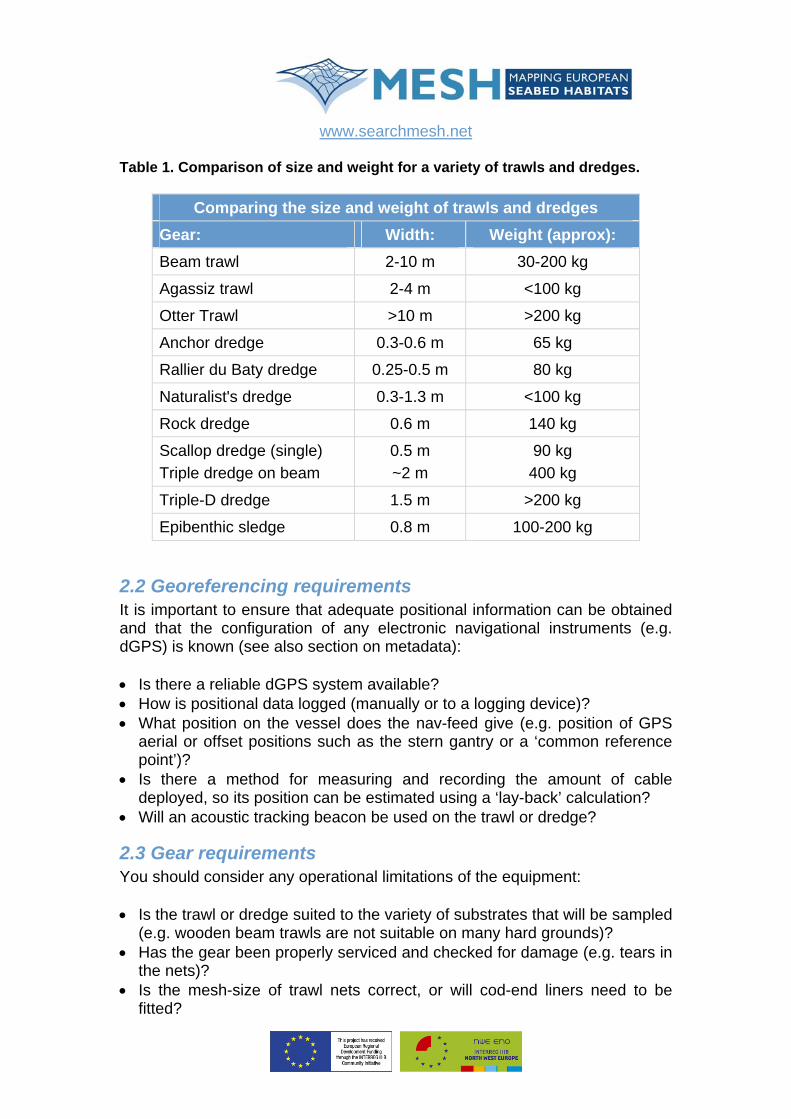
Table 1. Comparison of size and weight for a variety of trawls and dredges.
Comparing the size and weight of trawls and dredges Gear: Width: Weight (approx): Beam trawl 2-10 m 30-200 kg
Agassiz trawl 2-4 m <100 kg
Otter Trawl >10 m >200 kg
Anchor dredge 0.3-0.6 m 65 kg
Rallier du Baty dredge 0.25-0.5 m 80 kg
Naturalist's dredge 0.3-1.3 m <100 kg
Rock dredge 0.6 m 140 kg
Scallop dredge (single) Triple dredge on beam
0.5 m ~2 m
90 kg 400 kg
Triple-D dredge 1.5 m >200 kg
Epibenthic sledge 0.8 m 100-200 kg
2.2 Georeferencing requirements It is important to ensure that adequate positional information can be obtained and that the configuration of any electronic navigational instruments (e.g. dGPS) is known (see also section on metadata): • Is there a reliable dGPS system available? • How is positional data logged (manually or to a logging device)? • What position on the vessel does the nav-feed give (e.g. position of GPS
aerial or offset positions such as the stern gantry or a ‘common reference point’)?
• Is there a method for measuring and recording the amount of cable deployed, so its position can be estimated using a ‘lay-back’ calculation?
• Will an acoustic tracking beacon be used on the trawl or dredge?
2.3 Gear requirements You should consider any operational limitations of the equipment: • Is the trawl or dredge suited to the variety of substrates that will be sampled
(e.g. wooden beam trawls are not suitable on many hard grounds)? • Has the gear been properly serviced and checked for damage (e.g. tears in
the nets)? • Is the mesh-size of trawl nets correct, or will cod-end liners need to be
fitted?
www.searchmesh.net
An equipment checklist should be drawn up to ensure all relevant bits of gear, spares and maintenance equipment are taken. A suggested list of additional sample processing equipment is listed below: • Large containers for holding the sample (e.g. 60 litre fish boxes) • Sieving table with 5 mm mesh • Sorting bench • Buckets for measuring the sample volume (5 & 10 litre buckets with 1 litre
graduations) • Spade and scoop for handling and mixing the catch • Sets of forceps • Camera (to photograph the samples) • Hammer (to remove hermit crabs from their shell before weighing) • About 20 pots and buckets for sorting the catch • Tally counters • Motion compensated balances: 1 small (to ~300 g with precision of 0.1 g),
1 medium (to ~3 kg, precision 1 g), 1 large (to ~30 kg, precision 10 g) • Calibration weights for balances • Relevant field identification guides • Binocular microscope with lighting • Clipboards and general stationery (including waterproof pens and labels) • Sample storage pots of relevant sizes with sealing lids • Formalin for sample preservation (including buffer) • Personal protective equipment (clothing, head-gear, gloves, barrier cream) • Personal protective equipment for preparing diluted formalin (masks,
goggles) • Formalin spill-kit • Field record sheets for recording metadata and sample data (see example).
These provide a valuable prompt to ensure that all necessary metadata are recorded for each deployment.
2.4 Safety – hazardous substances Formaldehyde is a hazardous substance, so its transport, storage and use should comply with regulations under the Control of Substances Hazardous to Health (COSHH) and be subject to a COSHH Risk Assessment – an example of which is given in Appendix 1.
2.5 Briefings Once on board the vessel, all relevant personnel should be briefed on matters relating to: • Safety and operational hazards (including those relevant to Formalin); • Standard operating procedures for the gears to be used and the processing
of samples;
www.searchmesh.net
• Data and metadata recording requirements.
3. Test and verification protocols Trawls and dredges provide actual samples, rather than ‘streams of data’ (as in remote sensing techniques), so there are relatively few things that need to be tested and verified during the sampling procedure. However, the following points should be addressed: • The smallest mesh of the trawl or dredge should be measured and
recorded; • The dimensions of the mouth of the gear should be recorded; • Expert judgement should be used to assess whether or not the gear has
‘fished’ properly. The skipper, fishing master or crew often have most experience of the gear and should be consulted for an opinion. Where tows produce very small samples, a second tow should be made to verify that the reduced sample size is not attributable to failure of the gear to sample correctly. The scientist-in-charge should check each sample to verify its validity;
• On retrieval, the net should be checked for damage and if any significant tears are found, the sample should be declared invalid and discarded;
• If trawls have become filled with large volumes of sediment, the sample should be discarded, as the trawl will not have been sampling in the fashion for which it was designed;
• If an acoustic beacon (e.g. USBL – Ultra Short Base Line) tracking device is used to record the precise position of the towed gear, periodic checks should be made that the device is working correctly and providing a position astern of the vessel which approximates to that estimated by ‘layback’ calculation. Plotting or displaying the dGPS position of the vessel and the USBL-derived position of the gear in a navigation or GIS package should provide a sensible plot (i.e. the gear is neither far to the side nor in front of the vessel).
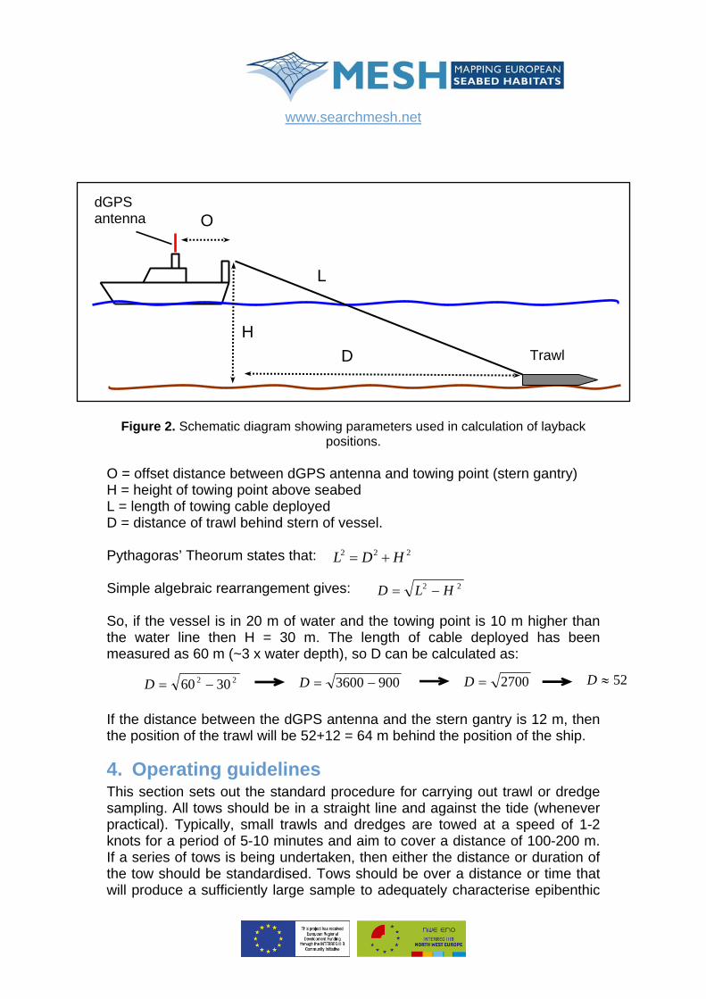
3.1 Layback calculation The distance of towed gear behind the vessel can be calculated by a simple application of Pythagoras’ Theorem and the measured offset between the dGPS antenna and the stern gantry or A-frame (Figure 2).
www.searchmesh.net
H D
L
OdGPS antenna
Trawl
Figure 2. Schematic diagram showing parameters used in calculation of layback
positions. O = offset distance between dGPS antenna and towing point (stern gantry) H = height of towing point above seabed L = length of towing cable deployed D = distance of trawl behind stern of vessel. Pythagoras’ Theorum states that: 22 HDL += 2
Simple algebraic rearrangement gives: 22 HLD −= So, if the vessel is in 20 m of water and the towing point is 10 m higher than the water line then H = 30 m. The length of cable deployed has been measured as 60 m (~3 x water depth), so D can be calculated as:
If the distance between the dGPS antenna and the stern gantry is 12 m, then the position of the trawl will be 52+12 = 64 m behind the position of the ship.
4. Operating guidelines This section sets out the standard procedure for carrying out trawl or dredge sampling. All tows should be in a straight line and against the tide (whenever practical). Typically, small trawls and dredges are towed at a speed of 1-2 knots for a period of 5-10 minutes and aim to cover a distance of 100-200 m. If a series of tows is being undertaken, then either the distance or duration of the tow should be standardised. Tows should be over a distance or time that will produce a sufficiently large sample to adequately characterise epibenthic
22 3060 −=D 9003600 −=D 2700=D 52D ≈
www.searchmesh.net
communities (10-60 litres), but not so large that the sample is unmanageable. Over expanses of sparsely populated sand, tow duration may have to be increased to 15-20 minutes in order to collect a suitable sample volume.
4.1 Pre-deployment • Check trawl/dredge is in good sampling condition and attached securely to
the towing warp; • Check the net or mesh is clean and there is no catch left in it from previous
sampling; • For trawls, make sure the cod-end is tied securely; • Make sure enough sample containers are available.
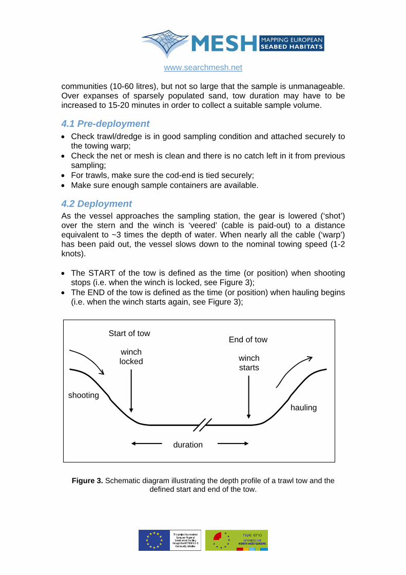
4.2 Deployment As the vessel approaches the sampling station, the gear is lowered (‘shot’) over the stern and the winch is ‘veered’ (cable is paid-out) to a distance equivalent to ~3 times the depth of water. When nearly all the cable (‘warp’) has been paid out, the vessel slows down to the nominal towing speed (1-2 knots). • The START of the tow is defined as the time (or position) when shooting
stops (i.e. when the winch is locked, see Figure 3); • The END of the tow is defined as the time (or position) when hauling begins
(i.e. when the winch starts again, see Figure 3);
Figure 3. Schematic diagram illustrating the depth profile of a trawl tow and the defined start and end of the tow.
hauling
duration
shooting
Start of tow
winch locked
End of tow
winch starts
www.searchmesh.net
• Record the time, position and water depth at the start and end of the tow. If
the positional data give the position of the vessel, then you should also record the length of cable that has been deployed so that the actual position of the trawl can be calculated by ‘layback’;
• Record the duration of the tow and/or the distance covered; • If, on returning to surface, it is evident that the gear has collected a
moderate amount of mud or sand, the net can be cleaned by gentle towing behind the vessel prior to bringing on board;
• When the gear is retrieved, it should be inspected for signs of damage. If significant damage has occurred that could have affected the catch composition, the sample should be declared invalid and the tow repeated;
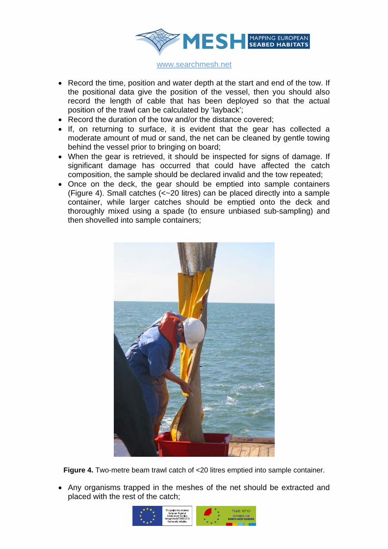
• Once on the deck, the gear should be emptied into sample containers (Figure 4). Small catches (<~20 litres) can be placed directly into a sample container, while larger catches should be emptied onto the deck and thoroughly mixed using a spade (to ensure unbiased sub-sampling) and then shovelled into sample containers;
Figure 4. Two-metre beam trawl catch of <20 litres emptied into sample container.
• Any organisms trapped in the meshes of the net should be extracted and placed with the rest of the catch;
www.searchmesh.net
• If required, the gear should be washed with a deck-hose or by towing
behind the vessel to remove dirt or trash (e.g. parts of small organisms).
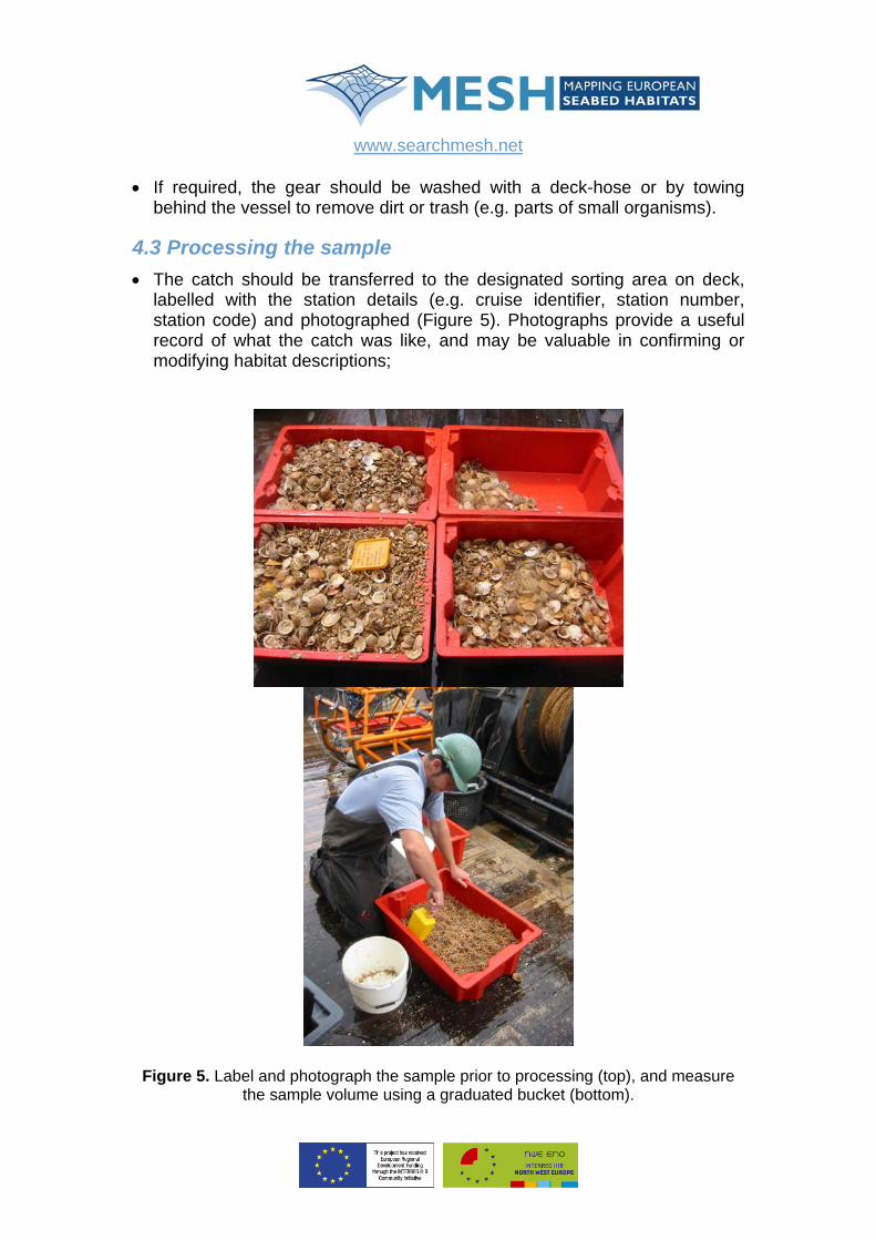
4.3 Processing the sample • The catch should be transferred to the designated sorting area on deck,
labelled with the station details (e.g. cruise identifier, station number, station code) and photographed (Figure 5). Photographs provide a useful record of what the catch was like, and may be valuable in confirming or modifying habitat descriptions;
Figure 5. Label and photograph the sample prior to processing (top), and measure the sample volume using a graduated bucket (bottom).
www.searchmesh.net
• The volume of the catch should be measured, in whole litres (Figure 5) and
entered onto the field record sheet. If the catch volume is less than 5 litres, the tow should be repeated to ensure that the low volume did not result from the net not fishing properly;
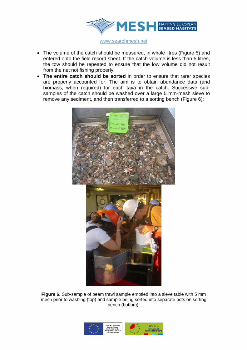
• The entire catch should be sorted in order to ensure that rarer species are properly accounted for. The aim is to obtain abundance data (and biomass, when required) for each taxa in the catch. Successive sub-samples of the catch should be washed over a large 5 mm-mesh sieve to remove any sediment, and then transferred to a sorting bench (Figure 6);
Figure 6. Sub-sample of beam trawl sample emptied into a sieve table with 5 mm mesh prior to washing (top) and sample being sorted into separate pots on sorting
bench (bottom).
www.searchmesh.net
• Thoroughly sort individual taxa into separate pots. Ideally, each pot should contain a different species, if field identification is unequivocal (e.g. Asterias rubens). However, it may be more convenient to temporarily sort taxa by higher taxonomic groups, such as a genus (e.g. Macropodia spp.), family (e.g. Paguridae – hermit crabs), order (e.g. Octopoda – octopuses), class (e.g. Bivalvia – bivalves), phylum (e.g. Bryozoa) etc. These can then be taken for more rigorous identification once sorting is complete. You may also need to use some pots to store particular substrate types, such as dead shells or cobbles, to which life forms are attached (see the section on ‘Special Considerations’ later).
4.4 Sub-sampling protocol Occasionally, catches are quite large (100 litres) and/or contain some species that are highly numerous (e.g. small ophiuroids). In such cases, the sample can be sorted in a series of aliquots, following the sub-sampling protocol described below. This is a time-saving device that ensures the whole catch is sorted. The purpose of sub-sampling is to obtain a reliable estimate of abundance for each of the highly numerous species in the catch. This can be achieved by fully sorting one or more sub-samples of known volume until the cumulative number of individuals exceeds a set target. This target is usually set at 100 individuals. The total abundance (and weight) of the species in question can then be accurately estimated by simple calculation (a process known as ‘raising’). Once this reliable estimate has been obtained, the species in question does not have to be ‘picked’ from the subsequent aliquots or sub-samples. This can provide significant time saving, as the highly abundant taxa are usually dealt with in the first few sub-samples. The principal is best illustrated by following a worked example, given below.
Worked example: sub-sampling protocol for trawls & dredges Total catch volume = 23 litres Sub-sample volumes: 1st = 5 litres, 2nd = 4 litres , 3rd ………
Taxon Count Volume
sampled (litres) Raised count Turritella communis 117 5 538
Ophiura ophiura 109 5+4 = 9 279
Asterias rubens 72 ALL 72
Liocarcinus holsatus 5 ALL 5
www.searchmesh.net
In this example, the total catch had a volume of 23 litres and it was noticed that two species, Turritella communis and Ophiura ophiura, were quite abundant, so sorting began on a 5-litre sub-sample. This first sub-sample contained 117 T. communis, 46 O. ophiura, 20 Asterias rubens and 2 Liocarcinus holsatus. As the number of T. communis exceeds the set target of 100, a reliable estimate can be made of their total abundance in the whole catch – (117÷5) x 23 = 538 – and this species can be ignored in any further sub-samples. For all the other species, there were fewer than 100 individuals in the first sub-sample, so you must continue to pick all of these species from the second sub-sample. The second sub-sample had a volume of 4 litres. This was sorted ignoring any T. communis. After sorting this second sub-sample, the cumulative number of O. ophiura had increased to 109 individuals, and the cumulative volume processed had increased to 9 litres (5+4). As the number of O. ophiura now exceeds the target of 100 individuals, a reliable estimate of their total abundance can be calculated as (109÷9) x 23 = 279, and they can be ignored in subsequent sub-samples. No other species exceeded the target of 100 individuals, so all species except T. communis and O. ophiura must be picked from the next sub-sample. It so happened that none of the remaining species were very numerous, so the remainder of the catch was sorted in one go. Once the whole catch had been sorted, the abundance of the remaining species was counted directly, and a note made that this number came from sorting ALL of the catch (i.e. the whole 23 litres).
4.5 Identification When the entire catch has been sorted, each taxon should be identified to the most precise taxonomic level practicable in the field (usually species level) using field identification guides. The identity, abundance (and weight) of each taxon should be logged on the field record sheet (NB. weight should be the blotted wet-weight). For quality assurance purposes, a reference collection should be kept for each trawl sample. An appropriate container should be labelled with all the necessary station information (e.g. cruise identifier, station number, station code) and filled with formalin once all reference species are added. The collection should contain at least one example of each taxon/species (except where the identification is unequivocal – e.g. Asterias rubens). The reference collection can then be processed on return to shore to verify field identification. Some taxa are not easily separated by rapid assessment in the field (e.g. Macropodia sp., Inachus sp., Ebalia sp., Galathea sp., Nucula sp., Abra sp., Pandalids etc). If pressure to complete the processing of samples is such that time is not available to adequately identify/separate taxa to species
www.searchmesh.net
level, then the entire catch (or sub-sample) of these taxa can be placed in the reference collection for later identification (and weighing) on shore.
4.6 Special considerations Hermit crabs should be removed from their shells prior to weighing. Shells are usually removed by cracking with a hammer and using forceps to extract the individual. Unattached ‘colonial’ taxa cannot be quantitatively enumerated. Once identified, their presence can be recorded in a manner suitable to the goals of the project. This could be a simple presence/absence noted on the field record sheet, or a semi-quantitative estimate of numbers as follows: • If there are <10 colonies, record the actual number of colonies; • If there are >10 colonies, estimate the number of colonies using a log scale
(101, 102, 103) and note this in the ‘count’ column of the field record sheet using the words ‘tens’, ‘hundreds’ or ‘thousands’ (to avoid confusion with truly numeric data).
For trawl and dredge samples, you should not use a relative abundance scale, such as the SACFOR scale (superabundant, abundant, common, frequent, occasional, rare). The MESH project has tested the use of this scale for trawl and dredge sampling and found it to be inappropriate for this application owing to the high variability in catch volumes, the uncertainty and variability in the area of seabed swept by the gear, and the subjective variability in applying the scale between different observers. The scheme suggested above, using ‘tens’, ‘hundreds’ and ‘thousands’, has proved reliable and can be applied consistently, even by inexperienced observers. Taxa attached to boulders or cobbles: Descriptive notes should be made to record the fauna associated with any cobbles that may occur in the catch (e.g. ‘cobbles encrusted with several types of sponge, hydroid colonies and a few barnacles’). Erect forms such as large hydroids should be removed from the hard substrate and added to the sorted sample. Errant forms that normally live attached to, or burrowing in, hard substrates (e.g. chitons, boring bivalves) should be removed and counted (and weighed). Encrusting forms such as barnacles and spirorbid worms should be treated as for unattached colonial taxa, using the ‘tens’, ‘hundreds’ and ‘thousands’ scale. Samples of all taxa should be kept in the reference collection for later identification in the shore laboratory. Taxa attached to biogenic surfaces: Occasionally, trawls can contain a significant proportion of biogenic materials, such as dead oyster shells, that provide a substrate for the attachment of sedentary organisms, such as anemones and sea-squirts. It can be very time consuming to inspect all of this shell material for attached taxa. Instead you can sub-sample the shell fraction
www.searchmesh.net
in the same way that you sub-sample the highly numerous taxa while sorting the catch. In other words, pick out these large shells from consecutive sub-samples until you have exceeded the target number of 100 shells. This sub-sample of the shell fraction can then be rigorously scrutinised to identify and enumerate the attached life forms, and the abundance of these life forms estimated by the ‘raising process’. So, if in the worked example above you had collected 143 shells from the first two sub-samples (cumulative volume of 9 litres), you would count all the organisms attached to these shells. Say there were 256 Anomia on these shells, this would have been from a 9-litre sub-sample, so the raised count would be (256÷9) x 23 = 654. Miscellaneous material: The presence of any miscellaneous material, such as egg cases, marine litter, wood and peat, should be noted on the field record sheet, along with any other informative notes that help to characterise the catch or the substrate on which it was collected (e.g. rocks, shell debris).
5. Quality control procedures A formal quality control procedure should be followed to check the field record sheet has been fully and properly completed. The observer should initial the sheet and pass it to a third party (e.g. scientist-in-charge) for checking. Any omissions or errors should be corrected by the observer. The third party should then initial the sheet to confirm the quality control check has been completed (see example field record sheet illustrated in the section below on Recommended Logging Information). Once checked, the metadata from the field record sheets should be entered into a dedicated meta-database for permanent storage. The person entering the data should initial the original field record sheet as part of the quality assurance/control procedure. The abundance and biomass data from each sample should be transferred to a spreadsheet for electronic storage and at the same time checked for any probable errors. On returning to the laboratory, the reference collections from each sample should be processed with the following objectives: • To fully identify taxa that were not separated to species during ship-board
processing; • To verify or correct the field identification of all other taxa. All errors and changes to the field identifications should be noted on the field record sheets and updated in the abundance/biomass spreadsheet. After this, a final quality check should be made by a third party, cross-checking the spreadsheet entries with the revised/corrected field record sheets for typographical errors. The spreadsheet can then be assigned a quality assured tag to indicate it has undergone all checks and verifications, and that the data are ready for analysis and/or transfer to a dedicated laboratory data

www.searchmesh.net
management system. In the UK, a biological database known as ‘Unicorn’ (developed by Unicomarine Ltd, using MS-Access) is becoming widely adopted by numerous institutes and the National Marine Monitoring Programme.
6. Data storage and backup recommendations The amount of data produced by trawl and dredge sampling is small in comparison to that produced by remote sensing techniques and should not present any problems in terms of storage capacity. It is advisable that suitable backup procedures are put in place to secure the following electronic files: • Database recording sample metadata • Spreadsheets recording abundance/biomass data • Any digital photographs (suitably labelled) • The position logging files. The original field record sheets should be archived according to local quality assurance policy (commonly storing paper records for five years and then re-assessing the option for disposal). The preserved reference collections from the samples should be archived according to local quality assurance policy and stored in a well-ventilated area until they are discarded.
7. Recommended logging information The clearest way to give guidance on recommended logging information is by way of annotated example. Figure 7 shows a copy of a pro-forma field recording sheet used by Cefas in 2006 for recording information (both data and metadata) for trawl and dredge (towed gears). The subsequent table (Table 2) explains the purpose of each field in the record in the sheet. The notes section should be used to record non-standard information on matters such as: • Reasons for rejecting the sample (e.g. to small, damage to net) • Presence of litter in the sample • Presence of large amounts of gravel/cobbles in the sample • Weather conditions (wind direction, sea state, etc) • Presence of artefacts (coal, bones, peat, etc of possible archaeological
interest). It is recognised that different surveys and institutes will have their own methods of recording data and metadata relevant to each sampling. The record sheet covers information that should be logged in the field and which

www.searchmesh.net
should accompany the sample data. Further, higher-level metadata will be required relevant to the research programme, the cruise/campaign, the area being survey and the analysis and management of the data. These are detailed in the general section on metadata.
www.searchmesh.net
Figure 7. Completed field record sheet from a Cefas survey in 2006. The top part of the form contains metadata about the sampling station, and the bottom part contains sample details including sample volume, any sub-sampling and at what volume, as
well as faunal count and weight.

www.searchmesh.net
Explanation of fields used in the towed-gear logsheet (with biomass)
Station Section for recording metadata relevant to the sampling station
Cruise code Unique identifier for the research cruise Survey name Name of the survey, indicating location and year Project code Unique code for the project undertaking the survey Station number Serial number of the sampling station Station code Unique identifier for the sampling station Date sampled Date on which the station was sampled Position logging file
Filename for positional data (generated by navigation system)
Log method Whether position logging was by time or by distance Log frequency Frequency of position logging (in seconds or metres) Vessel speed Speed over ground during the tow Distance Distance covered during the tow Gear Sampling gear used Water depth Water depth at the sampling station Bar code For use if samples are labelled with a bar code Notes: Any additional notes about the station or sample Positional data table
To record the time, fix number (dGPS) and/or position at points throughout the tow
Shoot When and where the gear was deployed (optional)
Lock Time and position at start of tow (when the winch was locked)
Haul Time and position at end of tow (when the winch begins hauling)
Sample table To record metadata about processing the sample
Status Records if the sample was processed on board, a reference collection kept and photograph(s) taken
Sieve mesh size Mesh size of the sieve used when washing the sampleSample volume Total volume of the sample
Sub-sample volumes
Volumes of successive sub-samples used for estimating abundance of highly numerous taxa (see Sub-sampling protocol)
Taxon table To record taxon identity, abundance and biomass Taxon Taxon name (to family, genus or species level) Kept? Y/N Were specimens included in the reference collection? Count Number of specimens in sample or sub-sample Weight Weight of specimens in sample or sub-sample Sub volume Sub-sample volume
Raised count Estimated abundance of the taxon in the whole sample

www.searchmesh.net
Raised weight Estimated weight of the taxon in the whole sample Quality control footnote
To provide an audit trail giving information on who has been involved with processing this data record
Completed by Person who completed the field record sheet
Checked by Person who checked the sheet was properly completed
Entered by Person who input records to meta-database and spreadsheets
Table 2. Explanation of data fields used in the field record sheet for towed gear.
8. Demobilisation notes Once the survey has finished, the trawl or dredge should be thoroughly washed with fresh water and checked for damage. Any damage should be repaired before the next survey. Before disembarking the vessel, a check should be made that all reference samples are accounted for. Special arrangement will need to be made for transporting formalin-preserved reference samples back to the laboratory (hazardous chemical).
9. Training All personnel involved with the trawl/dredge survey should be familiar with these recommended operating guidelines and any further standard operating procedure that may be specific to trawling operations on the vessel that will be used for sampling. No specific training or qualification is required (assuming that professional marine biologists will be undertaking the faunal identification). Inexperienced staff should be coached through the procedures (on-the-job training) before allowed to work unsupervised. Where required, employers should ensure that staff are properly trained in ‘heavy lifting’ techniques and are aware of COSHH and Health & Safety regulations.

www.searchmesh.net
Appendix 1
COSHH – RISK ASSESSMENT for Formaldehyde JOB OR PROCESS: Storage of 30% formaldehyde
solution on deck and the dilution of 30% formaldehyde to 10% and subsequent use of 10% formaldehyde for the preservation of benthic samples.
SUBSTANCES (a)HAZARD (b)OES (mg m-3) CODE 8 hour 15 minute 30%/10% formaldehyde solution 2C 2.5 2.5 Note: (a) Chemicals: 1 = very toxic, 2 = toxic, 3 = harmful 4 = corrosive, 5 = irritant, 6 = other pathogens: II, III or IV – Advisory Code on Dangerous Pathogens Carcinogens: C Note: (b) OES – Occupational Exposure Standard (or M.E.L - Maximum Exposure Limit if specified)
STAFF INVOLVED GRADE SEX (c)INVOLVEMENT Note: (c) Daily, weekly, monthly, occasionally CONTROL MEASURES TO BE USED: 30% formaldehyde solution should be stored on deck in a chemical storage container whenever possible. Dilution of 30% formaldehyde should always be carried out on deck. One person should decant the formaldehyde while another person holds a sufficiently wide-mouthed funnel in the filler hole of the aspirator. A saltwater hose should be available to irrigate any spillage. Large volumes (>20 L) of 10% formaldehyde solution should be stored on deck in an appropriate adequately secured dispenser. Smaller quantities used for the
www.searchmesh.net
preservation of biological samples in sealed plastic buckets may be stored either on deck or in a suitably ventilated ‘wet’ laboratory. All spillages of formaldehyde solution should be irrigated thoroughly with fresh or salt water. A formaldehyde spill-kit should be available for spillages of large quantities of 30% formaldehyde solution. The instructions on the label should be followed. Fumes generated during a spillage should be allowed to disperse before staff carry out work in that area. Formaldehyde should not be transported to or from a vessel in a situation where fumes generated from a spillage can come into contact with the driver or passengers. Large quantities of 30% formaldehyde solution must be carried in an approved chemical container. Smaller quantities of 30% formaldehyde and large quantities of 10% formaldehyde should be securely stored in a vehicle that separates the occupants of the vehicle from the formaldehyde (e.g. box van, flat-bed lorry or van). Containers of formaldehyde solution should be clearly labelled with details describing the nature of the contents. Spillages of formaldehyde in an enclosed vehicle should, where possible, be irrigated with water. If this is not possible, the formaldehyde should be allowed to evaporate and all fumes should be dispersed before the vehicle is used again. ___________________________________________________________________ SAFETY CLOTHING TO BE WORN: 30% formaldehyde – safety visor, gloves and seagoing waterproofs 10% formaldehyde – safety goggles and gloves (e.g. safety spectacles, safety goggles, face visor, gloves, dust mask, respirator) ___________________________________________________________________ SPECIAL TRAINING NEEDS: None ___________________________________________________________________ ASSESSMENT OF EXPOSURE RISK: Risks are low when the above procedures are followed. 1. The main short-term hazard is that of eye contact with accidentally spilled
formaldehyde. Should this occur, the eye must be irrigated immediately with an approved in-date saline eyewash, or copious quantities of clean fresh water.
2. If a spillage of formaldehyde should occur on deck or in the wet lab, the area
should be thoroughly irrigated with sea-water and staff should avoid affected areas until fumes have dissipated.