TRANSPORT POLICY AND DEVELOPMENT IN VIET NAM
27
TRANSPORT POLICY AND DEVELOPMENT IN VIET NAM Le Tuan Anh Director General – International Cooperation Department Ministry of Transport of Viet Nam International Seminar Transforming Urban Transportation in ASEAN Big Cities July 19, 2019, Tokyo - Japan
Transcript of TRANSPORT POLICY AND DEVELOPMENT IN VIET NAM

TRANSPORT POLICY AND DEVELOPMENT IN VIET NAM
Le Tuan AnhDirector General – International Cooperation Department
Ministry of Transport of Viet Nam
International Seminar
Transforming Urban Transportation
in ASEAN Big Cities
July 19, 2019, Tokyo - Japan

MAIN POINTS
I. INFORMATION ABOUT VIET NAM/MOT
II. TRANSPORT DEVELOPMENT PLANNING
1. Road2. Railway3. Maritime4. Inland waterway5. Aviation6. Achievements7. Constraints
III. DEVELOPMENT PLAN/ORIENTATION
IV. URBAN TRANSPORT
1. Present situation2. Future plan

I. INFORMATION ABOUT VIET NAM
▪ Viet Nam is located on the eastern Indochinese Peninsula
▪ Total area: 331,212 km2 (65th)
▪ Coastline is 3,260 km long
▪ Population: 97 million (15 th)
▪ GDP: 241 billion USD (47th )
▪ Growth rate: 6,7% in 2018
▪ Per capita: 2,726 USD (129th)
▪ Capital: Hanoi
▪ Largest city: Ho Chi Minh

❑ Current status
✓ Total length: 252,669 km (24.203kmof the highway, 969km ofexpressway);
✓ Another 654km of expressway: underconstruction under PPP.
✓ Transport share: cargo: 77%,passenger: 94,5%
❑ Future plan
✓ Expressway: 21 routes of total 6411km by 2030;
✓ Continue to maintain importantnational routes;
✓ Upgrade routes connecting withLaos, Cambodia, China and GMS,ASEAN.
II. TRANSPORT DEVELOPMENT PLANNING
1. Road
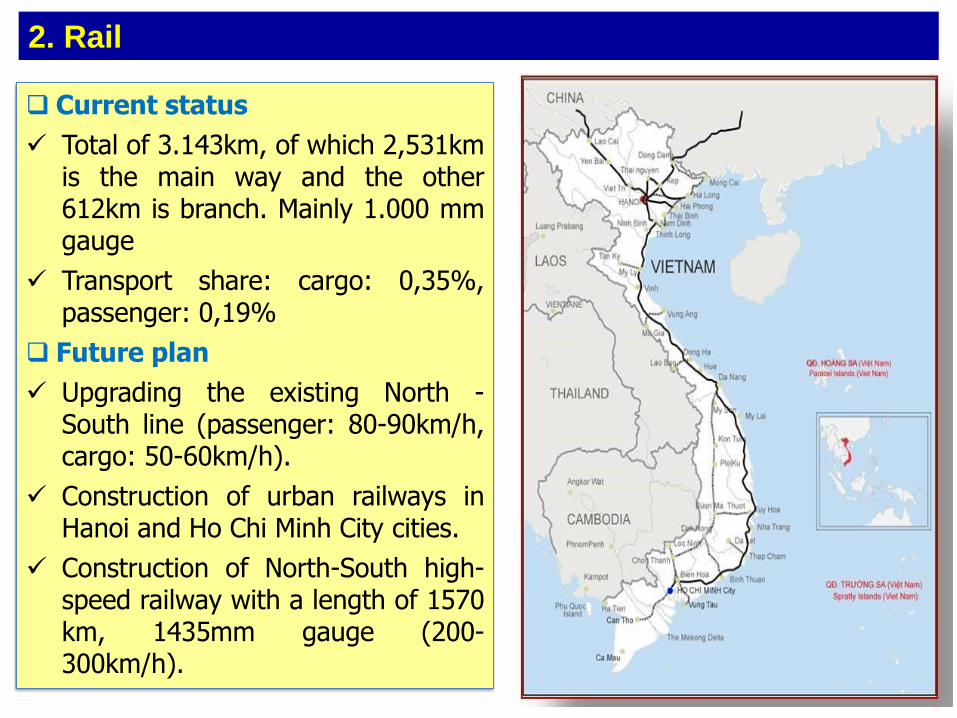
❑ Current status
✓ Total of 3.143km, of which 2,531kmis the main way and the other612km is branch. Mainly 1.000 mmgauge
✓ Transport share: cargo: 0,35%,passenger: 0,19%
❑ Future plan
✓ Upgrading the existing North -South line (passenger: 80-90km/h,cargo: 50-60km/h).
✓ Construction of urban railways inHanoi and Ho Chi Minh City cities.
✓ Construction of North-South high-speed railway with a length of 1570km, 1435mm gauge (200-300km/h).
2. Rail

❑ Current status
✓ More than 2360 rivers and canals with atotal length of 42,000km, of which19,000 km are being exploited; 255inland ports; ICD
✓ Transport share: cargo: 17,6%,passenger: 4,2%
❑ Future plan
✓ Priority to upgrading important rivers(Red River, Thai Binh River in the Northand Tien River and Hau River in theSouth) to serve ships operating 24/24.
✓ To upgrade main ports, and build anumber of cargo and passenger wharvesin the North, Central and South regionsto raise the capacity of waterwaytransport.
3. Inland waterway

❑ Current status
✓ Coastline of 3260 km, 45 seaports, 272berths, design capacity of 550-580million tons/year. Sea transportaccounts for 80% of import and exportvolume.
✓ Transport domestic share: cargo: 4,7%,passenger 0%
❑ Future plan
✓ In the North: Develop Lach Huyendeep-water port, for ships up to100,000 DWT.
✓ Central: Upgrade existing ports. Buildingnew int’l passenger ports in Hue, DaNang and Nha Trang provinces.
✓ South: Develop Cai Mep - Thi Vai portarea, for ships up to 200,000 DWT.
✓ Develop dry ports to support logistics.
4. Maritime

❑ Current status
• There are 22 airports: 9international and 13 domestic.
• Transport share: cargo: 0,02%,passenger: 1,06%
❑ Future plan
• Upgrade airport infrastructure toreach the total capacity of 144million pax/year, of which:
✓ 9 int’l airports with capacity of 121.5million pax/year.
✓ 13 domestic airports with capacity of22.5 million pax/year.
• Invest a new Long Thanh int’lairport with a total design capacityof 100 million pax/ per year and 5million tons of cargo/year.
5. Aviation

1
6. Past 10 years achievements
❑ Infrastructue
• Expressway: Now 969 km (2011: 89 km)
• Seaport Capacity: 550-570 Mil. Ton/year (2011: 240-260 Mi. ton)
• Airport Capacity: 90 Mil pax/year (2011: 40 Mil pax)
❑ Transportation
• Average growth rate for 2011-2018 period: for cargo: 9,3%/year,highest for road: 10,04%; for passenger: 9,06%/year, highest forair:16,7%.
• Transport quality is improved
• Capacity and infratrusture quality ranking in 2011: 95/144 → 79/138 in2017.
• Logistics Performance Index: 39/160 widely and 3/10 in ASEAN

1
7. Constraints
❑ Infrastructue
• Yet an integrated and modern infrastructure system
• Expressway: not many and not integrated yet
• Railway: less developed, no high-speed rail
• Airport and seaport: not so modern, not a hub or transshipment one
• Inland waterway: under exploited for modern transport modes
❑ Transportation
• Transport quality: not high, unreasonable transport structure
• Traffic accident: high, unpredictable
❑ Causes
• Funding mobilization and budget allocation: limited compared with highdemand
• Investment policy: not consistent, complicated procedures → affectimplementation schedule/progress

DEVELOPMENT PLAN/ORIENTATION
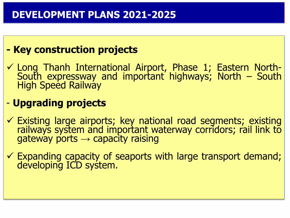
DEVELOPMENT PLANS 2021-2025
- Key construction projects
✓ Long Thanh International Airport, Phase 1; Eastern North-South expressway and important highways; North – SouthHigh Speed Railway
- Upgrading projects
✓ Existing large airports; key national road segments; existingrailways system and important waterway corridors; rail link togateway ports → capacity raising
✓ Expanding capacity of seaports with large transport demand;developing ICD system.

DEVELOPMENT PLANS 2021-2025
- Restructuring transport modes
✓ Reduce road transport share, increase inland waterway andrailway transport capacity;
✓ Focus on developing multimodal transport and logisticsservices by applying IT → Reduce logistics cost
- Urban transport
✓ Develop the metro systems in Hanoi and Ho Chi Minh Cities (target: 20 ÷ 25% of demand);
✓ Expand bus and MRT systems.
- Transport safety
✓ Improve traffic safety (reducing annual accidents rate at least5% of the deaths, the injuries and the number of accidents).

1
✓ Solve traffic congestion; improve the efficiency of wholesystem;
✓ Attain reasonable cost; safe, fast, comfortable andenvironment friendly transport;
✓ Enhance quality of transport services and logistics services;
✓ Improve the capacity and quality of public passengertransport services in urban and inter-regional areas
✓ Simplify administrative formalities
DEVELOPMENT ORIENTATIONS TO 2030

URBAN TRANSPORT
1. Present situation
2. Future plan

✓ Population: 97 million people, with
- 3.4 million cars
- 45 million motorbikes
✓ Transport means: Private vehicles ~ 90%
✓ Private transport vehicles increase 12-15%/year
1. Present situation
III. URBAN TRANSPORT

Public transport: account for ~ 10% of demand
✓ Hanoi: 91 bus lines, 1.500 buses and 1 BRT line, 11.500 trips/day
✓ Ho Chi Minh: 138 bus lines, 2.800 buses, 17.000 trips/day
Cont’d

NATIONWIDE
52.000 taxies
HANOI:
- 18.000 taxies;
- Serving120 million passengers per year.
HCM
- 11.000 taxies;
- Serving 200 million passengers per year.
Cont’d
TAXI

BRT: 01 line in service in Hanoi

Metro: a 13 km line of MRT in Hanoi under construction (expecting soon)
Cont’d

Cont’d
Negative Impact:
• All day traffic congestion
• Fuel consumption/Econimic loss
• Environment pollution
• High potential for traffic accidents
• Time loss/delays
• Additional stress
• Slow/inefficient emergency response and delivery services
• Etc.

2. Future plan
In Hanoi City: ≈ 8 Mil.
✓ Develop MRT lines: 9 lines (460 km, of which 75,6 km is underground). Total investment: 40 Bil. USD
✓ 03 lines are underconstructed

In Ho Chi Minh City: Population ≈ 10 Mil.
✓ Develop MRT lines: 8 lines (174 km). Total investment: 18 Bil. USD
✓ 03 lines are underconstructed

In Hanoi and HCM cities till 2030: Expanding capacity of BRT upto 07 lines, more bus lines, more MRT lines, more bridges, more parking sites

✓ Adjusting work hour; school hour
✓ Relocate headquaters of government offices, hospitals, universities
✓ Build new ring roads/ more bridges
✓ Build a light rail network
✓ Add bus lanes/ Remove bus lanes
✓ Limit private vehicles
✓ Apply IT/Smart city
3. Recommended Solutions – Short term and Long term
1
Cont’d
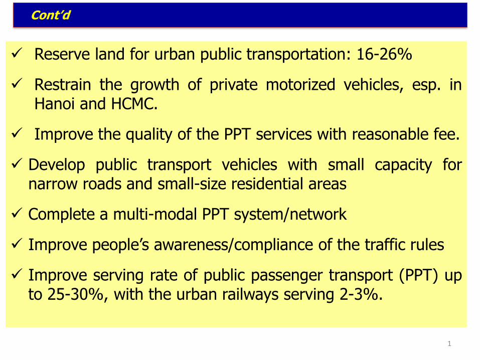
✓ Reserve land for urban public transportation: 16-26%
✓ Restrain the growth of private motorized vehicles, esp. inHanoi and HCMC.
✓ Improve the quality of the PPT services with reasonable fee.
✓ Develop public transport vehicles with small capacity fornarrow roads and small-size residential areas
✓ Complete a multi-modal PPT system/network
✓ Improve people’s awareness/compliance of the traffic rules
✓ Improve serving rate of public passenger transport (PPT) upto 25-30%, with the urban railways serving 2-3%.