Transport - ncrpb.nic.in Revised Regional Plan 2021/08... · State of Environment Report for Delhi...
27
T T r r a a n n s s p p o o r r t t 6.1 INTRODUCTION NCR Planning Board had prepared a Functional Plan on Transport for National Capital Region with perspective year 2032 which is an Integrated Multimodal Transport Plan (IMTP) for NCR. The Functional Plan was prepared after review of demand and supply of transport infrastructure in NCR. The Functional Plan was approved by the NCR Planning Board in November, 2009. The Plan recommended Integrated Multi-Modal Transportation System for NCR to improve the mobility of both people and goods. It also recommended systematic development of Transport System for fast and efficient movement of traffic, particularly for commuter traffic and to achieve sustainable development of the region. The Plan comprises following components: 1. Regional Rapid Transit System (RRTS) 7. Bus Terminals 2. New Rail Lines 8. Logistic Hubs 3. Regional Mass Rapid Transit System (MRTS) 9. Integrated Freight Complexes 4. Up-gradation of Roads 10. Highway Facilities Centres, and 5. Expressways 11. Airports 6. Bus Transport System The Plan was circulated for implementation to NCR participating State Governments in July 2010, February 2011 and December 2011. It was also circulated to Ministry of Railways and Ministry of Road Transport and Highways in February 2011 and in January 2012. 6.2 OBJECTIVES Objectives of the Transport Plan are: (i) to provide efficient and economic rail and road based transportation system (including mass transport systems) well integrated with the landuse patterns to support balanced regional development; (ii) to provide accessibility to all parts of the region and discourage transit of passengers and goods through the core area of NCT-Delhi by constructing Peripheral Expressways/ bypasses and thereby opening new areas for economic development; (iii) to provide suitable public transport system in NCR to shift people from private transport to public transport, and (iv) to reduce the vehicular air pollution. 6.3 EXISTING NCR TRANSPORT SYSTEM The transport system of NCR consists of a good road network and rail corridors catering to intra-city, inter-city commuters and long-distance traffic. The freight traffic is also substantial in the region which is mainly carried by road. NCR has a road network of about 36,305 km; a large bus fleet of 58,300 buses (registered in NCR), a rail network of more than 1000 km; and an International Airport at Delhi. 6.3.1 Road Network The existing road transport network is ‘radial’ in nature. It comprises Expressways, National Highways, State Highways, Major District Roads and Other District Roads. Ministry of Road Transport and Highways vide notification no. S.O.542(E) dated 05.03.2010 rationalized the numbering system of National Highways in India. The revised numbers as well as old number are given in following table. The old numbers of National Highways are popular and people can easily recognize. Therefore, old numbers 6
Transcript of Transport - ncrpb.nic.in Revised Regional Plan 2021/08... · State of Environment Report for Delhi...

TTrraannssppoorrtt 6.1 INTRODUCTION
NCR Planning Board had prepared a Functional Plan on Transport for National Capital Region with perspective year 2032 which is an Integrated Multimodal Transport Plan (IMTP) for NCR. The Functional Plan was prepared after review of demand and supply of transport infrastructure in NCR. The Functional Plan was approved by the NCR Planning Board in November, 2009. The Plan recommended Integrated Multi-Modal Transportation System for NCR to improve the mobility of both people and goods. It also recommended systematic development of Transport System for fast and efficient movement of traffic, particularly for commuter traffic and to achieve sustainable development of the region. The Plan comprises following components:
1. Regional Rapid Transit System (RRTS) 7. Bus Terminals 2. New Rail Lines 8. Logistic Hubs 3. Regional Mass Rapid Transit System
(MRTS) 9. Integrated Freight Complexes
4. Up-gradation of Roads 10. Highway Facilities Centres, and 5. Expressways 11. Airports 6. Bus Transport System
The Plan was circulated for implementation to NCR participating State Governments in July 2010, February 2011 and December 2011. It was also circulated to Ministry of Railways and Ministry of Road Transport and Highways in February 2011 and in January 2012.
6.2 OBJECTIVES
Objectives of the Transport Plan are: (i) to provide efficient and economic rail and road based transportation system (including mass transport systems) well integrated with the landuse patterns to support balanced regional development; (ii) to provide accessibility to all parts of the region and discourage transit of passengers and goods through the core area of NCT-Delhi by constructing Peripheral Expressways/ bypasses and thereby opening new areas for economic development; (iii) to provide suitable public transport system in NCR to shift people from private transport to public transport, and (iv) to reduce the vehicular air pollution.
6.3 EXISTING NCR TRANSPORT SYSTEM The transport system of NCR consists of a good road network and rail corridors catering to intra-city, inter-city commuters and long-distance traffic. The freight traffic is also substantial in the region which is mainly carried by road. NCR has a road network of about 36,305 km; a large bus fleet of 58,300 buses (registered in NCR), a rail network of more than 1000 km; and an International Airport at Delhi.
6.3.1 Road Network
The existing road transport network is ‘radial’ in nature. It comprises Expressways, National Highways, State Highways, Major District Roads and Other District Roads. Ministry of Road Transport and Highways vide notification no. S.O.542(E) dated 05.03.2010 rationalized the numbering system of National Highways in India. The revised numbers as well as old number are given in following table. The old numbers of National Highways are popular and people can easily recognize. Therefore, old numbers
6

58 Regional Plan 2021
are used in this Chapter for further reference. The list of Expressways and National Highways in NCR is given in Table 6.1.
Table 6.1: New and Old Numbers of National Highways in NCR S.No. Roads Name of Roads with old numbers of
National Highways New Numbers of National Highways
i. Expressways Delhi-Gurgaon Expressway - Noida-Greater Noida Expressway - Yamuna Expressway -
ii. National Highways Converging to Delhi
NH-1 : Delhi-Ambala NH-44 NH-2: Delhi-Agra NH-44 NH-8: Delhi-Jaipur NH-48 NH-10: Delhi-Hisar NH-9 NH-24: Delhi-Moradabad NH-9
iii. National Highways Converging to Ghaziabad
NH-58 : Delhi-Meerut NH-34 (Ghaziabad-Meerut) NH-91: Delhi-Aligarh NH-34 (Ghaziabad-Bulandshahar)
iv. Other National Highways in NCR
NH-71: Rohtak-Jhajjar-Bawal NH-352 NH-71A:Rohtak-Gohana-Panipat NH-709 NH-71B: Rewari-Palwal NH-919 NH-119 : Meerut-Bijnor NH-34 NH-93 : Aligarh-Chandausi NH-509 NH-235:Meerut-Hapur-Bulandshahar NH-334 NH-236: Mehrauli-Gurgaon NH-236: Mehrauli-Gurgaon NH 11A: Pratapgarh-Gole Ka Bas NH-148
Source: Ministry of Road Transport and Highways (MoRT&H)
Five National Highways converge to Delhi which also serve the daily inter-city commuters. The existing road network of NCR is shown in Map 6.1. Apart from these National Highways, a number of State Highways also strengthen the regional road network. In addition, Major District Road (MDR) and Other District Roads (ODR) act as important linkages to these highways.
6.3.1.1 Road Density
The Sub-region wise road density in the NCR is presented in Table 6.2. Delhi has the highest road density of 2,103 km/100 sq.km followed by Haryana (59.30 km/100 sq.km). Rajasthan and UP Sub-regions have almost same road density of 51 km/100 sq.km.
Table 6.2: Sub-Region Wise Road Density in NCR
Sub-region NCR National Highway State Highway MDR
Area (Sq. Km)
Total Length (Km)
Road Density
Length (Km)
Road Density
Length (Km)
Road Density
Length (Km)
Road Density
Haryana 13413 7954 59.30 528 3.93 1448.2 10.79 580 4.32 UP 10853 5504 50.71 321.4 2.96 805.6 7.42 432.66 3.98 Rajasthan 7829 3976 50.79 35.3 0.45 1010.1 12.90 326.76 4.04 Total 32095 17434 54.32 884.70 2.76 3263.90 10.17 1339.42 4.14 Note: 1) Excludes NCTD 2) Does not includes ODRs & VRs. 3) Road Density in km per 100 sq. km of area. Source: Functional Plan on Transport for NCR-2032
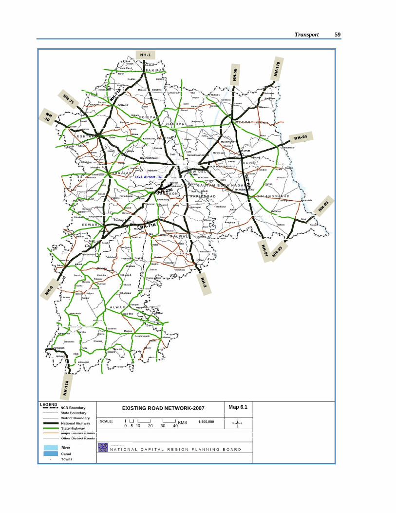
Transport 59
NH-1
Map 6.1
HA PUR
Map 6.1
EXISTING ROAD NETWORK-2007

60 Regional Plan 2021
Table 6.3 represents comparison of road density in NCR (excluding Delhi) with all India. It would be seen that density of National Highways (2.76) and State Highways (10.17) in NCR are much higher than the all India density of National Highways (1.99) and State Highways (4.19). But density of Major District Roads (MDR) in NCR (4.14) is much lower as compared to the all India density (14.23).
Table 6.3: Comparison of Road Density in NCR and All India S. No. Category NCR All India 1. National Highways 2.76 1.99 2. State Highways 10.17 4.19 3. Major District Road 4.14 14.23
Source: Functional Plan on Transport for NCR-2032 Note: Road Density in km per 100 sq. km of area.
6.3.1.2 Transport Scenario in Delhi The vehicles in Delhi have grown at the rate of 7.41% per annum between 2003-04 and 2010-11 (Table 6.4). Number of private vehicles has increased substantially from 3.98 million to 6.52 million during that period. However, the growth rate of commercial vehicles (9.42%) is higher than the growth rate of private vehicles (7.29%).
Table 6.4: Growth of Vehicles in Delhi S.No. Category of Vehicle No. of Vehicles (in Million) Annual Compound Growth
Rate 2003-04 2010-11 1. Private Vehicles 3.98 6.52 7.29% 2. Commercial Vehicles 0.22 0.42 9.42%
Total 4.20 6.93 7.41% Source: Delhi Statistical Handbook, 2011 The numbers of private vehicles (cars and two-wheelers) have grown exponentially between 2003 and 2010 (Figure 6.1). Figure 6.2 represents the increase in road network in Delhi. Delhi had 1922 km of roads per 100 sq.km. area in 2001. The road network has increased from 28,508 km in 2000 to 29,030 km in 2008, while the number of vehicles has doubled from 33.7 lakh in 2000 to 63.0 lakh in 2008. This has resulted both in heavy traffic congestion and reduction in vehicular speed.
6.3.1.3 Volume to Capacity Ratio Volume to Capacity Ratio (V/C) is a measure to evaluate the extent of utilization of road capacity. Ideally, it should be always less than 1. The V/C for design service volume for rural roads is 0.5 and for urban roads it is 0.7 as per IRC norms. Corrective measures are required when it exceeds the norms.
The V/C Ratio assessed in NCR (excluding Delhi) for 2950 km of road network are presented in Table 6.5. It is observed that 31% of primary road network have V/C ratio more than 0.6, which is above the norms of V/C ratio of 0.5 for rural roads.
Figure 6.1: Vehicular Growth in Delhi (Category-wise)
0
450000900000
13500001800000
225000027000003150000
360000040500004500000
Cars & Jeeps Two Wheelers All Others
Source: Delhi Statistical Handbook, 2011
Figure 6.2: Increase in road network in Delhi
Source: State of Environment Report for Delhi 2010

Transport 61
Table 6.5: Distribution of Road Length by V/C Ratio V/C Ratio Road Length %Age 0.001 - 0.3 779.30 26.42
0.3 - 0.6 1253.40 42.49 0.6 - 0.99 697.60 23.65
> 1 219.70 7.45 Total 2950.00 100.00
Source: Functional Plan on Transport for NCR-2032 As per the survey conducted by RITES for Government of NCT-Delhi in 2007, V/C ratio varied between 1.01 to 2.83 on major roads in Delhi, which is higher than 0.7 for urban roads. A table showing V/C ratio on some of the important roads in Delhi is given in Annexure 6/I.
6.3.1.4 Traffic and Travel Pattern
In 2007, detailed traffic and transport surveys were conducted to prepare the Functional Plan on Transport for NCR-2032. Based on these surveys, it was observed that NCR is a high movement area with high intensity traffic of all types. It shows that 2,21,575 vehicles (3,50,694 PCUs) enter and exit NCR (Outer Cordon) on an average per day (2007). In NCR, National Highways account for 75% (vehicles) of the total traffic volume. The traffic volume increased to 2,72,891 vehicles (3,87,565 PCUs) at the Middle Cordon (CNCR boundary); and reached a high of 12,10,896 vehicles (12,27,873 PCUs) at Inner Cordon (NCT-Delhi boundary). At the Outer Cordon (NCR boundary), out of 94,659 passenger modes nearly 97% of passenger modes movement was Internal-External and External-Internal and only 3% was External-External. The inter-spatial movement pattern of passenger modes showed a high share between ‘Rest of NCR’ and ‘Outside NCR’ areas. Out of 63,352 goods modes at Outer Cordon, 9% were non-destined. At the Middle Cordon (CNCR boundary), out of 1,56,838 passenger modes, Internal-External and External-Internal passenger mode movement accounted for 69%. The share of through movement was 4%. A high intensity of interaction between CNCR and outside areas was observed. Internal-Internal passenger movement was 27% within CNCR. Out of 67,859 goods modes, 7% were non-destined. At the Inner Cordon (NCT-Delhi boundary), out of 11,07,043 passenger modes, the non-destined traffic was as high as 23%. About 37% passenger modes exit Delhi and 38.4% passenger modes enter in to Delhi in a day. Out of 1,03,853 goods modes crossing at Inner Cordon, 30% were non-destined, which is very high. This shows the need of bypass to Delhi. 6.3.2 Rail System 6.3.2.1 Indian Railways The NCR rail network falls under three zonal railways (Northern, North-Western and North-Central) and five divisions. Six rail corridors converge to Delhi and three rail corridors converge to Ghaziabad. The zone-wise rail corridors are as under:
Zone-wise Rail Corridors Northern Zone Delhi-Ghaziabad Delhi (Shahadara)-Shamli-Saharanpur Delhi-Shakurbasti-Rohtak Delhi-Subzimandi-Sonepat-Panipat Ghaziabad-Hapur-Garmukteshwar Ghaziabad-Meerut Delhi-Faridabad-Palwal Delhi-Gurgaon-Rewari
North-Western Zone Rewari-Alwar
North-Central Zone Palwal-Mathura Ghaziabad-Khurja
The rail network in NCR is shown in Map 6.2.

62 Regional Plan 2021
New Line Commissioned in January 13
Map 6.2EXISTING RAIL NETWORK-2007
MEWAT

Transport 63
A total of 625 trains including 253 long distance passenger trains and 176 EMU trains (suburban trains) operate at the three major railway stations of Delhi viz. Old Delhi, New Delhi and Hazrat Nizamuddin. Apart from this, a large number of goods trains move into and out of NCR. The commuter traffic in NCR is about 0.61 million per day (2007).
The mixed running of goods trains, slow passenger trains, short distance commuter trains and long distance trains such as mail express trains, high speed Rajdhani, Shatabdi express, etc., have reduced the speed of trains in Delhi area as well as on radial routes.
6.3.2.2 Metro Rail in NCR
Delhi Metro Rail Corporation (DMRC) has completed the construction of about 190 km of metro corridor in Phase I & II, which is fully operational. The Phase III network of 136 km has been sanctioned and under execution which is expected to be completed by December 2016. Average daily ridership of Delhi Metro was 19.65 lakh in March, 2013. Regional Plan-2021 for NCR proposed for the extension of Delhi Metro Rail System to CNCR towns. Accordingly, it has now been extended to Noida, Gurgaon and Ghaziabad and is proposed to be extended to Faridabad and Bahadurgarh. The existing and proposed Metro corridors in NCR are given in Annexure 6/II.
6.3.3 Bus System
NCR is served by an extensive bus service operated by STUs of GNCT-Delhi (DTC), Haryana (HSRTC), Uttar Pradesh (UPSRTC), Rajasthan (RSRTC), Uttarakhand (UTC), Punjab (PRTC), Himachal Pradesh (HRTC) and Jammu & Kashmir (J&K SRTC); and a host of private operators. Density of buses and other vehicles per lakh population in the sub-regions of NCR and at the national level are given in the Table 6.6. Table 6.6: Number of Vehicles and Buses per lakh population in NCR Sub regions (year 2007)
Source: Functional Plan on Transport for NCR-2032, ** estimated
Against average ratio of 71 buses per lakh population at national level, the NCR’s average is 132. The NCR Sub-regions of Uttar Pradesh and Rajasthan have much lower ratio of 46 and 43 buses respectively while Haryana Sub-region has a ratio of 64 buses. Delhi has significantly higher bus ratio of 267, as it serves intra-city travel demand. On the other hand, vehicle/population ratio of all type of vehicles in the NCR sub regions is much higher (17718) than the national average of 6,739. Out of a total of 58,346 buses registered in the NCR, 6216 (29%) are stage carriage buses. Only 11% of all the registered buses and 37% of the stage carriage buses are owned by the STUs and the remaining 89% registered bus and 63% stage carriage are owned by private operators. Ministry of Urban Development under JNNURM scheme sanctioned 1900 buses in NCR cities, as per details given in Box 6.1.
State
Population in Lakh
Total no. of vehicles in NCR
(lakh)
No of vehicles per
lakh population
Total no. of buses
registered in NCR
No. of buses registered as stage carriage No of buses per
lakh population in NCR State NCR Sub-
region STUs Total
NCTD 163.5 163.5 51.4 31437 43639 3449 **9000 267 Haryana 237.4 108.5 15.4 14194 6964 1285 4030 64 UP 1867.6 136.7 9.3 6818 6234 1204 2421 46 Rajasthan 634.1 34.8 2.5 7069 1509 278 1509 43 Total 2902.6 443.5 78.6 17718 58346 6216 16960 132 India 2004 10791.2 727.2 6739 768000 71
Box 6.1: Buses sanctioned in NCR under JNNURM by the Ministry of Urban Development i. Delhi - 1600 ii. Faridabad - 150 iii. Meerut - 150
64 Regional Plan 2021
6.3.4 Intermediate Public Transport System (IPTS) A large number of auto-rickshaws and taxis operate in cities and towns within NCR. On an average, an auto rickshaw carries 96 passengers per day and other vehicles like RTVs carry 114 passengers per day in NCR. The Intermediate Public Transport System (IPTS) suffers from many constraints like lack of terminal facilities, technological obsolescence, uneconomical fares, parking etc. There is an urgent need to facilitate growth and operation of IPTS within the NCR for providing last mile connectivity with MRTS, RRTS and Bus System. 6.3.5 Air Transport Indira Gandhi International Airport (IGIA) is the major airport in NCR. In terms of traffic volumes, it is second to Mumbai, and handles annually about 35.88 million passengers and 0.56 million tonnes of cargo traffic (2011-12). Presently it has three operational runways with a peak hour handling capacity of 75 aircrafts movement. There are three separate terminal areas for domestic passengers, international passengers and cargo. The international passenger traffic at Delhi airport is 30% of the total passenger traffic. However, the international cargo traffic is 65% of the total cargo traffic. The Airport connects 60 destinations all over the globe through 51 international airlines. Of the passenger traffic, about 76% was generated within NCTD, 19% in NCR (excluding NCTD) and 5% beyond NCR (2007). Besides, it is expected to handle a large quantity of cargo on commissioning of Delhi Mumbai Industrial Corridor (DMIC).
6.4 STATUS OF REGIONAL PLAN-2021 TRANSPORT PROPOSALS Various projects related to transport are proposed in Regional Plan-2021. The present status of these projects is given in Table 6.7. Table 6.7: Proposals of Regional Plan-2021 and Present Status S.No. Regional Plan Proposals Present Status Implementing Agency Phase –I (2001-2011) Road Projects
1. Western Peripheral Expressway Under Implementation HSIDC, Govt. of Haryana 2. Eastern Peripheral Expressway Under Implementation NHAI, MoRT&H 3. Present ring road, outer ring road, and five
National Highways (radial roads) up to CNCR towns to be developed as per expressway standards.
NH-8 (Delhi-Gurgaon) has been implemented
NHAI
NH-24 (Delhi-Ghaziabad) is under implementation
MoRT&H
Remaining yet to be implemented NHAI/PWD, Delhi 4. Four laning of the following road sections
Bahadurgarh-Rohtak-NCR Border (NH10)
Under implementation NHAI
Rohtak-NCR Border (NH71) Under implementation NHAI
Ghaziabad-Meerut-NCR Boundary (NH58) Implemented NHAI Ghaziabad-Bulandshahr-Khurja-NCR Boundary
(NH91) Under implementation NHAI
Gurgaon-Alwar Partially implemented
(4 lane up to Nuh and 2 lane from Nuh to Alwar)
PWD, Haryana and Rajasthan
Panipat-Gohana-Rohtak (NH71A) Under implementation NHAI Jhajjar-Rewari Road (NH71) Under implementation NHAI Elevated Road connecting Delhi with Faridabad
near Badarpur Implemented NHAI
Rail Projects 5. Regional Rapid Transit System Corridors have been revised on the direction
of Planning Commission -
6. Rewari-Bhiwadi Rail Link Survey work completed Ministry of Railways 7. Rohtak-Hansi Rail Link Work in progress Ministry of Railways

Transport 65
S.No. Regional Plan Proposals Present Status Implementing Agency Phase –II (2011-2021) Road Projects
8. Ghaziabad-Meerut Expressway Under implementation NHAI 9. Up-gradation of Grid Roads Bhiwadi-Rewari Implemented PWD (B&R), Haryana Rohtak-Sonepat Implemented PWD (B&R), Haryana Sonepat-Baghpat Implemented PWD, UP Baghpat-Meerut Implemented PWD, UP Meerut-Hapur-Bulandshahar (NH-235) 2 laning work Implemented, further NHAI
has taken up its 4 laning work PWD, UP & NHAI
Khurja-Palwal Implemented PWD (B&R), Haryana & UP
Palwal-Bhiwadi Implemented PWD (B&R), Haryana Rail Projects
10. Regional Rapid Transit System Corridors have been revised on the direction of Planning Commission
-
11. Orbital Rail Corridor - Ghaziabad-Noida-Faridabad-Gurgaon-
Bahadurgarh-Kundli-Ghaziabad Corridor has been revised in the Functional Plan on Transport for NCR-2032
-
‘Reciprocal Common Transport Agreements’ for unrestricted movement of buses, taxis and auto-rickshaws for ‘Contract Carriage’ and ‘Stage Carriage’ have been signed by all the participating States of NCR on 14.10.08 and 22.04.10 respectively. Its implementation is underway. Presently, 12000 NCR taxis and 7500 NCR buses are plying in NCR.
6.5 TRANSPORT PROJECTS IMPLEMENTED THROUGH NCR PLANNING BOARD FUNDING IN NCR
NCR Planning Board has been providing financial support to NCR participating States for projects related to development of Transport sector which includes up-gradation of roads, construction of bus terminals & truck terminals/transport nagar, rail over bridges (RoB), etc. in NCR. Since its inception, NCRPB has financed sixty eight projects (till March 2013) in the transport sector for which loan amount of Rs.2915 crore has been sanctioned. Out of these, thirty five transport projects have been completed. The details of completed transport sector projects are presented in Annexure 6/III. These completed projects have contributed to improvement of more than 900 km of road length in NCR and its CMAs. This has helped in improving the road connectivity within NCR, both in terms of network and level of service.
As stated in earlier section, the road density in NCR is higher than the national average. Therefore, now emphasis should be more on moving towards improvement of existing roads through better Operation and Maintenance (O&M) and financing sustainable transport projects taking care of services for not only motorized modes of transport but also non-motorised transport (NMT) and pedestrians.
6.6 FUTURE OVERALL TRAVEL DEMAND
The Regional Plan-2021 has estimated the population of NCR to be 64.14 million by 2021. Population and employment data of NCR has also been projected up to year 2032. The estimated population and employment for the year 2032 would be 86.67 million and 32.67 million respectively. It is estimated that the intra-regional travel demand in NCR would increase from 3.63 million person trips in 2007 to 13.2 million by 2032 i.e. about 4 fold increase. In addition, there are inter-regional and through trips. In terms of tonnage, 6.4 million tonnes of goods would be transported by the year 2032 in NCR. The modal split of trips for base year and horizon year is shown in Table 6.8.

66 Regional Plan 2021
Table 6.8: Modal Split of Trips in NCR Mode Year - 2007 Year - 2032
Trips per day (Million) % Trips per day (Million) % Bus 1.03 27.83 6.18 46.7 Sub-urban Rail/ RRTS/ Regional MRTS
0.61 16.61 2.91 21.9
i) Sub-urban Rail/ RRTS 0.61* 16.61 1.70 12.8 ii) Regional MRTS - - 1.21 9.1 Auto-Rickshaw - - 0.66 5.0 Car 1.12 31.90 2.22 16.7 2-Wheeler 0.87 23.57 1.28 9.6 Total 3.63 100% 13.2 100%
*It is as per EMU/DMU/other intercity trains
The utilization of roads has reached to a saturation point leading to traffic jams and increased pollution load. Hence, a conscious effort is required to implement a strategy to shift the modal share from private modes to public.
The implementation of Functional Plan on Transport proposals will reduce the dependence on private modes from 56% (2007) to 26% (2032) and the public transport share will increase from 44.5% (2007) to 73.6% (2032) including IPT. The share of rail based public transport system will also increase from present level of 17% in 2007 to 22% in 2032. Moreover, number of commuters using rail based system in NCR will increase from 0.61 million per day in year 2007 to 2.91 million per day in year 2032, out of which the proposed RRTS system will cater to 1.7 million trips per day.
6.7 POLICIES AND STRATEGIES Following policies/strategies are recommended to achieve the overall objectives of Regional Plan-2021 for sustainable development of NCR:
i. Provide linkages amongst Metro/Regional Centres in the outlying areas of NCR. ii. Connect Metro/Regional Centres with the Capital by an efficient and effective transport network
for facilitating faster movement of traffic among such centres and NCT-Delhi. iii. Link the Sub-regional Centres with effective and efficient transport network for facilitating the
faster movement of traffic among such centers and higher order settlements. iv. Directly link other urban nodes having maximum attracting and generating capacities of person
trips. v. Unrestricted movement of buses, taxis, and auto-rickshaws within NCR.
vi. Develop activities keeping in view rail and road linkages in Central NCR having better accessibility and at the same time relieving pressure on the existing transport routes converging at NCT-Delhi.
vii. Transit Oriented Development (TOD) need to be promoted to reduce travel demand as well as encourage public transport system.
viii. Execution of the Regional Plan-2021 proposals of Integrated Mass Rapid Transport System (MRTS), Regional Rapid Transport System (RRTS), Expressways and Bypasses without further delays.
ix. Provide multi-modal stations wherever required. x. Promote unified fare collection system.
xi. Promote Non-Motorised Transport in NCR. xii. Reducing vehicular air pollution by promoting Mass Transport System and use of cleaner
technologies. xiii. Use of Intelligent Transport System (ITS) for Traffic Management. xiv. Integration of Landuse and Transport Planning.

Transport 67
xv. Promote Public Transport System in the cities of NCR and allocate road space on a more equitable basis.
xvi. State Governments should follow National Urban Transport Policy-2006 (NUTP).
6.8 TRANSPORT PLAN FOR NCR
The Map 6.3 presents proposed Multi Modal Transport Plan for NCR- 2032.
6.8.1 Road System
6.8.1.1 Expressways, Regional Arterial and Regional Sub-Arterial Roads Road Network forms the main component of Functional Plan on Transport for NCR-2032. A hierarchical classification comprising Regional Expressways, Regional Arterials, Regional Sub-Arterials, Regional Collectors / Distributors and Regional Access Roads is proposed. An extensive Regional Expressway Network extending over a length of 1107 km is proposed. At the second level, the existing radial National Highway corridors converging into Delhi and circular National Highways are proposed to be developed as part of Regional Arterials. The proposed phase wise programme for development of Expressways in NCR is shown in Table 6.9.
Box 6.2: Summary of Proposals of Functional Plan on Transport for NCR-2032 i) An extensive network of 1107 km Regional Expressways. ii) An extensive network of 2046 km Regional Arterials, which includes strengthening of National
Highways and up-gradation of State Highways. iii) An extensive network of 631 km Regional Sub-Arterials, which includes strengthening of State
Highways and up-gradation of Major District Roads. iv) An extensive network of Regional Collectors/Distributors, which includes strengthening of Major
District Roads and up-gradation of Other District Roads. v) An extensive network of Sub-Regional Access Roads. vi) An extensive Bypass system around the Regional urban centres. vii) A large number of interchanges on the road network system. viii) A Network of rail based Regional Rapid Transit System (RRTS) of 640 km on dedicated tracks. ix) New Rail lines linking some of the Regional Centres and Metro Centres in the form of Regional
Orbital Rail Corridor (RORC) and Inner Regional Orbital Rail Corridor (IRORC) for a total length of 629 km.
x) An extended network of Metro Rail System to connect Regional Centres. xi) Extensive fleet of Bus System with supporting infrastructure like depots, workshops, etc. xii) Bus Terminals and Rail Terminals enabling integration and smooth transfer amongst modes xiii) Logistics Hubs xiv) Highway Transport Facility Centers xv) Integrated Freight Complexes and Truck Terminals xvi) Second International Airport in NCR
Small airports in the Metro Centres and Regional Centres
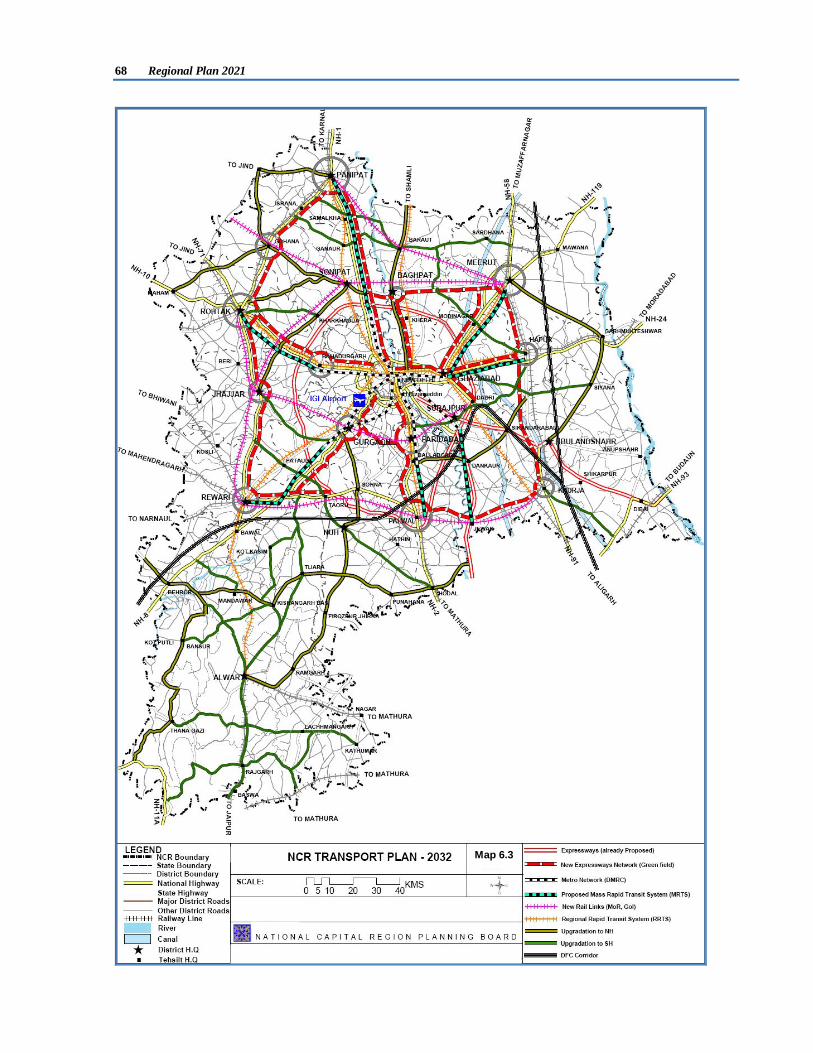
68 Regional Plan 2021
Map 6.3

Transport 69
Table 6.9: Phase-wise Programme for Development of Expressways in NCR S. No. Categories Length
(Km) ROW
(m) Type Phase-I Phase-II
2012-17 (lanes)
2017-22 (lanes)
Expressways 1 Ganga Expressway (within NCR)* 65.0 100 Greenfield 6 6 2 Yamuna Expressway (within NCR)* 65.0 100 Greenfield 6** 8 3 Western Peripheral Expressway 135.6 100 Greenfield 8*** 10 4 Eastern Peripheral Expressway 136.0 100 Greenfield 8*** 10 Total 401.6
Regional Expressways (Greenfield Alignments) 1 Delhi - Panipat 69.75 100 Greenfield 6 6 2 Delhi - Ghaziabad 15.34 100 Greenfield 4*** 6 3 Ghaziabad - Modinagar - Meerut 33.21 100 Greenfield 4*** 6 4 Ghaziabad - Hapur 25.90 100 Greenfield 4 6 5 Delhi - Faridabad - Palwal 44.75 100 Greenfield 4 6 6 Gurgaon - Manesar - Dharuhera 64.55 100 Greenfield 4 6 7 Panipat - Gohana - Rohtak 58.40 100 Greenfield 4 6 8 Rohtak - Rewari 80.01 100 Greenfield 4 6 9 Rewari - Dharuhera - Bhiwadi - Palwal 21.38 100 Greenfield 4 6 10 Palwal - Khurja 50.98 100 Greenfield 4 6 11 Khurja - Hapur - Meerut 72.44 100 Greenfield 4 6 12 Meerut - Baghpat - Sonepat 37.48 100 Greenfield 4 6 13 Ghaziabad - Bulandshahr till Dadri 18.17 100 Greenfield 4 6 14 Delhi - Baghpat 36.28 100 Greenfield 4 6 15 Gurgaon - Faridabad 18.72 100 Greenfield 4 6 16 Delhi - Bahadurgarh - Rohtak 57.94 100 Greenfield 4 6
Total Length 705.3 Source: Functional Plan on Transport for NCR-2032, *Proposals of Govt. of UP, ** Implemented, *** Under Implementation
In addition to above, NHAI has recently proposed Delhi-Jaipur Expressway. On this Expressway, two spurs to connect Bhiwadi (38 km) and Jhajjar (25 km) are also proposed in NCR. The total length of Delhi-Jaipur Expressway in NCR including the two spurs will be 130 km. It is proposed to provide access to Behror from this expressway with a small spur. Government of Rajasthan has also proposed a 100 m wide link road of expressway standard between Neemrana and Bhiwadi.
The proposed phase-wise programme for development of Regional Arterial roads in NCR is shown in Table 6.10. In case RoW is not available, elevated roads could be considered for increasing the number of lanes. Table 6.10: Phase-wise Programme for Development of Regional Arterials in NCR
S. No. Regional Arterials Length (km)
ROW (m)
Existing Configuration
Phase-I Phase-II 2012-17 (lanes)
2017-22 (lanes)
1 Delhi-Panipat (NH-1) 84.0 100 6 8*** 10 2 Delhi - Ghaziabad (NH-24) 21.0 100 4 8A 10 3 Ghaziabad - Modinagar - Meerut (NH-58) 53.0 60 4 6*** 8 4 Ghaziabad - Dadri - Bulandshahr - Khurja (NH-91) 48.0 60 2 6* 8 5 Ghaziabad - Hapur (NH 24) 37.0 60 2 6 8 6 Delhi - Faridabad - Ballabgarh - Palwal (NH-2) 60.0 100 4 8*** 10 7 Delhi - Gurgaon (NH-8) 30.0 100 8 10B 10 8 Gurgaon - Manesar - Dharuhera (NH-8) 49.0 100 4 8*** 10 9 Delhi - Bahadurgarh (NH-10) 28.0 60 4 6* 8 10 Bahadurgarh - Rohtak (NH-10) 42.0 60 2 4* 6 11 Panipat - Gohana - Rohtak (NH-71A) 67.0 60 2 4* 6 12 Rohtak - Rewari (NH-71) 80.0 60 2 4* 6 13 Rewari - Palwal (NH-71 B) 83.0 60 2 4 6 14 Palwal - Khurja 56.0 60 1 4 6
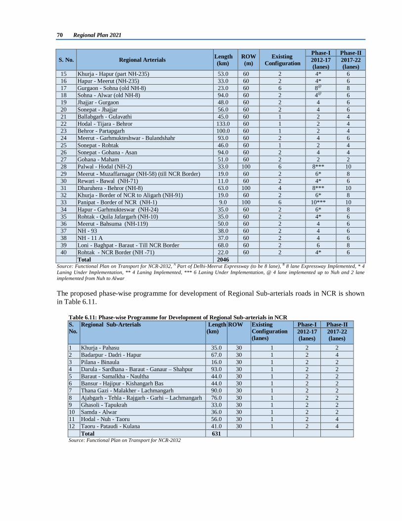
70 Regional Plan 2021
S. No. Regional Arterials Length (km)
ROW (m)
Existing Configuration
Phase-I Phase-II 2012-17 (lanes)
2017-22 (lanes)
15 Khurja - Hapur (part NH-235) 53.0 60 2 4* 6 16 Hapur - Meerut (NH-235) 33.0 60 2 4* 6 17 Gurgaon - Sohna (old NH-8) 23.0 60 6 8@ 8 18 Sohna - Alwar (old NH-8) 94.0 60 2 4@ 6 19 Jhajjar - Gurgaon 48.0 60 2 4 6 20 Sonepat - Jhajjar 56.0 60 2 4 6 21 Ballabgarh - Gulavathi 45.0 60 1 2 4 22 Hodal - Tijara - Behror 133.0 60 1 2 4 23 Behror - Partapgarh 100.0 60 1 2 4 24 Meerut - Garhmukteshwar - Bulandshahr 93.0 60 2 4 6 25 Sonepat - Rohtak 46.0 60 1 2 4 26 Sonepat - Gohana - Asan 94.0 60 2 4 4 27 Gohana - Maham 51.0 60 2 2 2 28 Palwal - Hodal (NH-2) 33.0 100 6 8*** 10 29 Meerut - Muzaffarnagar (NH-58) (till NCR Border) 19.0 60 2 6* 8 30 Rewari - Bawal (NH-71) 11.0 60 2 4* 6 31 Dharuhera - Behror (NH-8) 63.0 100 4 8*** 10 32 Khurja - Border of NCR to Aligarh (NH-91) 19.0 60 2 6* 8 33 Panipat - Border of NCR (NH-1) 9.0 100 6 10*** 10 34 Hapur - Garhmukteswar (NH-24) 35.0 60 2 6* 8 35 Rohtak - Quila Jafargarh (NH-10) 35.0 60 2 4* 6 36 Meerut - Bahsuma (NH-119) 50.0 60 2 4 6 37 NH - 93 38.0 60 2 4 6 38 NH - 11 A 37.0 60 2 4 6 39 Loni - Baghpat - Baraut - Till NCR Border 68.0 60 2 6 8 40 Rohtak - NCR Border (NH -71) 22.0 60 2 4* 6
Total 2046 Source: Functional Plan on Transport for NCR-2032, A Part of Delhi-Meerut Expressway (to be 8 lane), B 8 lane Expressway Implemented, * 4 Laning Under Implementation, ** 4 Laning Implemented, *** 6 Laning Under Implementation, @ 4 lane implemented up to Nuh and 2 lane implemented from Nuh to Alwar
The proposed phase-wise programme for development of Regional Sub-arterials roads in NCR is shown in Table 6.11.
Table 6.11: Phase-wise Programme for Development of Regional Sub-arterials in NCR S. No.
Regional Sub-Arterials Length (km)
ROW Existing Configuration (lanes)
Phase-I Phase-II 2012-17 (lanes)
2017-22 (lanes)
1 Khurja - Pahasu 35.0 30 1 2 2 2 Badarpur - Dadri - Hapur 67.0 30 1 2 4 3 Pilana - Binaula 16.0 30 1 2 2 4 Darula - Sardhana - Baraut - Ganaur – Shahpur 93.0 30 1 2 2 5 Baraut - Samalkha - Naultha 44.0 30 1 2 2 6 Bansur - Hajipur - Kishangarh Bas 44.0 30 1 2 2 7 Thana Gazi - Malakher - Lachmangarh 90.0 30 1 2 2 8 Ajabgarh - Tehla - Rajgarh - Garhi – Lachmangarh 76.0 30 1 2 2 9 Ghasoli - Tapukrah 33.0 30 1 2 2 10 Samda - Alwar 36.0 30 1 2 2 11 Hodal - Nuh - Taoru 56.0 30 1 2 4 12 Taoru - Pataudi - Kulana 41.0 30 1 2 4 Total 631 Source: Functional Plan on Transport for NCR-2032

Transport 71
Development of Other Roads Apart from above mentioned roads, all the roads proposed in Functional Plan on Transport for NCR-2032 need to be developed to improve connectivity in NCR. The other roads proposed from time to time to improve Inter-State/Intra-State connectivity should also be considered for development. The State Governments should not only restrict themselves up to only primary network proposed in the Plan but also develop the other lower hierarchy of roads to connect blocks and villages, which need to be elaborated in their respective Sub-regional Plans. 6.8.1.2 High Occupancy Lanes along all Major Regional Roads It is proposed that dedicated High Occupancy Vehicle (HOV) Lanes (one on either side) be provided along all the proposed and existing Expressways, National Highways and other major Regional Arterial roads/corridors with six lanes and above to provide priority for movement of road based bus system. The HOV lanes would facilitate high efficiency and productivity of the regional bus transport system. While mainly meant for public transport, the HOV lanes may also be made accessible for use by private modes having occupancy of more than a fixed number e.g. it could be minimum of more than two occupants for private cars. The vehicles in HOV lanes may also be given a concession in toll charges. These measures would promote reduction in the number of personalized modes on the network system. 6.8.1.3 Interchanges Regional Road Network System is envisaged as a high capacity, high speed and high quality road network. Access control is required to be provided at important intersections between the roads of same class or different classes enabled with full or partial grade separated interchanges. The general policy proposed is as under:
1 Between Expressway & Expressway Full Interchange 2 Between Expressway & Regional Arterial – (National
Highways) Full or Partial Interchange
3 Between Regional Arterial & Regional Arterial Partial Interchange 4 Regional Arterial & Regional Collector (State Highway) Partial Interchange 5 Between Regional Collector & Regional Collector At Grade (with proper design)
Source: Functional Plan on Transport for NCR-2032
While the above policy is a general guideline, there may be variations based on traffic volume and other needs.
6.8.1.4 Bypass System around All Major Urban Centers
It is important that intra-regional and inter-regional traffic is segregated from intra-urban traffic. Most of the Master Plans for Regional Centers have proposed some systems of bypass roads. However, in the context of envisaged growth of the regional urban centers, it is proposed that necessary provisions may be made in the Master Plans for new bypass systems around each of the urban centre planned and developed with appropriate interchanges. These bypasses should be elevated/ access controlled on high embankment as far as possible to avoid becoming urban arterial roads in future.
6.8.1.5 Integrating and Interfacing Regional and Urban Road Network Systems
It is proposed that each urban centre, as part of its road network master plan, identify an internal network system comprising radial and concentric ring roads to be developed to expressway standards and integrated with the regional road system so that the destined traffic moves seamlessly to its destination point within the urban center.
6.8.1.6 Bicycles and Pedestrian Facilities
The ‘Strategies and Methodologies for Mitigation’ for bicycle path and pedestrian path as recommended by National Mission on Sustainable Habitat, MoUD need to be adopted by State Governments for development of Non-motorised facilities in the towns of NCR. The strategies are reproduced below:

72 Regional Plan 2021
“Significant GHG mitigation can be achieved through modal shift by providing all arterial roads more than 25 m right of way to have minimum of 2.5 m pedestrian path (with trees) and proper street furniture and 2.5 m bicycle path preferably in each direction as a mandatory measure. Where it is not possible to provide a dedicated cycle path because of right of way being narrow, traffic calming measures to reduce the speed of traffic to 30 kmph need to be adopted. Without properly engineered pedestrian path and bicycle path, the roads are unsafe for walking and bicycling and safety of walking and bicycling needs to be ensured.” 6.8.1.7 Integrated Freight Complexes A high intensity of goods movement by road and rail systems is envisaged in NCR. It includes consignments to a variety of destinations within and outside the region. Therefore, there is a need to develop Integrated Freight Complexes (IFCs) at the outer edge of the urban area at the location of interface of the regional and urban network systems. Apart from the road system, the IFCs need to be integrated with the regional rail system. IFCs at all the regional urban nodes integrated with the Outer Grid Roads/ National Highways/ Expressway Systems are proposed in following towns:
i. Sonepat vii. Bulandshahr ii. Baghpat viii. Palwal iii. Bahadurgarh ix. Alwar iv. Ghaziabad x. Behror v. Jhajjar xi. Shahjahanpur or Neemrana vi. Gurgaon
Following five IFCs are also proposed in the Master Plan for Delhi-2021 for the integration of goods movement by road and rail in Delhi. These IFCs are required to meet the need for Delhi only and need to be implemented expeditiously.
i. Madanpur Khadar (NH-2) ii. Ghazipur (NH-24) iii. Narela (NH-1) iv. Dwarka (NH-8) v. New site in Urban Extension (Rohtak Road) Tikri Kalan
Master Plans, where these provisions are not kept need to be reviewed and revised to provide land for IFCs and integrating them with intra-urban transport network system.
6.8.1.8 Highway Facility Centres
The Highway Facility Centres (HFC) needs to be planned and developed on a comprehensive basis. The HFC’s need to include parking, fuelling, servicing and repairs, telephone and telecommunication, restaurants and motels, medical, police, godown, weigh bridge, entertainment, banking (ATMs), and a host of other needed services. These HFCs need to be developed along the highways, spread over an area of 5 to 10 ha with a spacing of 50-60 km.
6.8.1.9 Road Traffic Safety Strategies
In order to minimize the number, frequency and severity of accidents in NCR, the following recommendations are made:
i. Provision of adequate and effective traffic control and safety devices during construction and maintenance activities.
ii. Provision of road side amenities for pedestrians, cyclists and other special road users such as rickshaws, vans, buses, trucks, etc.
iii. Adoption of Intelligent Transport Systems (ITS) for road & road environment and traffic guidance.
iv. Implementation of the guidelines for road safety prepared by Indian Road Congress (IRC).

Transport 73
6.8.2 Regional Rail System
6.8.2.1 Regional Rapid Transit System (RRTS) Commuter service is extremely important for movement of people within NCR. The rail based inter-regional commuter demand is estimated to be 1.7 million passengers per day by 2032. An extensive commuter network designated as Regional Rapid Transit System (RRTS) is proposed with dedicated electrified tracks using modern signal and communication systems to enable safe, high speed and high frequency services. The corridor-wise estimated travel demand and phasing of Regional Rapid Transit System (RRTS) corridors is shown in Table 6.12.
Table 6.12 Travel Demand and Phasing of RRTS Corridors S. No.
Regional Rapid Transit System Length (km)
Travel Demand, 2032 (Passenger Trips per Day)
Phase -I (2012-17)
Phase -II (2017-22)
1 Delhi - Panipat 89 273264 2 Delhi-Shahdara-Baraut 56 48223 3 Delhi – Meerut 67 385586 4 Delhi - Hapur 57 114213 5 Delhi - Khurja 83 229134 6 Delhi – Ballabgarh – Palwal 60 214123 7 Delhi – Rewari – Alwar 158 608643 8 Delhi - Rohtak 70 81388 Total Length 640
Source: Functional Plan on Transport for NCR-2032
In 2009, Task Force for RRTS for NCR constituted by Planning Commission under the Chairmanship of Secretary, Urban Development had prioritized following three corridors for implementation in Phase-I: S. No. RRTS Corridor Length (km)* Estimated cost** (Rs. in crore, Sept. 2011)
1 Delhi-Sonipat-Panipat 111.2 18755 2 Delhi-Gurgaon-Rewari-Alwar 180.0 32141 3 Delhi-Ghaziabad-Meerut 90.2 21274
Total 381.4 72170 * As per Feasibility Study, **Estimated in the Feasibility Study, including escalation and IDC (with Central and State Taxes).
6.8.2.2 Orbital Rail Corridor In view of recommendations of the Functional Plan on Transport for NCR-2032, the earlier Orbital Corridor proposed in Regional Plan for NCR-2021 has been revised and following two Orbital Rail corridors have been proposed:
i. Regional Orbital Rail Corridor (RORC) ii. Inner Regional Orbital Rail Corridor (IRORC)
i. Regional Orbital Rail Corridor (RORC)
The Regional Orbital Rail Corridor (RORC) connecting Panipat-Rohtak-Jhajjar-Rewari-Palwal-Khurja-Hapur-Meerut-Panipat enables movement of passenger and goods at the regional level avoiding Delhi Area. In this corridor Panipat-Meerut, Palwal-Khurja & Palwal-Bhiwadi-Rewari are new rail lines. The survey work of both the lines has been completed. The Rohtak-Jhajjar-Rewari rail line is commissioned. Meerut-Khurja and Rohtak-Gohana-Panipat Corridors are existing corridors. RORC also interconnects the Regional Centers which would increase their accessibility and potential for growth.
ii. Inner Regional Orbital Rail Corridor (IRORC)
In addition to RORC, five other rail lines within NCR are proposed to strengthen the connectivity of the rail system which will form Inner Regional Orbital Rail Corridor (IRORC). They are Sonepat-Jhajjar, Jhajjar-Gurgaon, Gurgaon-Faridabad, Faridabad-Dadri and Meerut-Baghpat-Sonepat. Dadri-Ghaziabad-Meerut corridor is existing corridor. Moreover, Dadri-Ghaziabad and Ghaziabad-Meerut are also part of RRTS Corridors.

74 Regional Plan 2021
Both these Orbital Rail Corridors i.e. RORC and IRORC will connect most of the Metro Centres and Regional Centres in NCR.
6.8.2.3 Other New Rail Line The Sonepat-Gohana-Jind rail line has been proposed to connect Jind. This line is already sanctioned and is under execution. The corridor-wise estimated passenger loading excluding freight traffic with implementation phasing of RORC, IRORC and new rail line is shown in Table 6.13. Table 6.13: Passenger Loading and Phasing of RORC, IRORC and New Rail Link S. No.
New Rail Links
Length (km) Passenger Loading per day
Phase –I (2012-17)
Phase –II (2017-22)
1 Panipat - Meerut (RORC)* 86 25505 2 Rewari - Bhiwadi - Palwal (RORC)* 76 129284 3 Palwal - Khurja (RORC)* 53 129284 4 Rohtak - Rewari (RORC)** 80 16110 5 Sonepat - Jhajjar (IRORC) 56 203750 6 Jhajjar - Gurgaon (IRORC) 40 12420 7 Gurgaon - Faridabad - Dadri (IRORC) 53 187981 8 Meerut - Baghtpat - Sonepat (IRORC) 66 22727 9 Sonepat - Gohana - Jind (new rail link)*** 51 10282 10 Rohtak - Hansi Rail Link (new rail link)*** 68 -
Total Length 629 Source: Functional Plan on Transport for NCR-2032, * Survey Works Completed, ** Work Completed, ***Work in Progress
6.8.2.4 Dedicated Freight Corridors (DFC) In view of growing demand of high speed and high capacity trains, Indian Railway proposes to segregate passenger and goods train movements. It is proposed to develop dedicated fright corridors with high geometric, engineering and other standards. The goods trains are proposed to run at an average speed of 50-60 kmph (maximum speed 100 kmph), with a heavier axle load of 32.5 tonne and a longer tracking load of 15,000 tonne. The train lengths would be longer (1500 meters) with a new wagon design with increased height and width that would enable double stack container service. The Dedicated Freight Corridor Network is proposed to cover the golden quadrilateral of rail network as shown in Map 6.4. Out of this, presently, two corridors namely Western Dedicated Freight Corridor and Eastern Dedicated Freight Corridor have been approved for development. The Western DFC connects Delhi with Mumbai with a length of 1483 km while Eastern DFC with a length of 1835 km will connect Ludhiana with Dankuni (WB).
Both the Dedicated Freight Corridors run through NCR. The Western DFC enters NCR on the south-west from Jaipur to Rewari. From Rewari, a new line is proposed to link Delhi – Agra main line at Asaoti and from there onwards, this line is extended to end at Dadri interconnecting with the Eastern DFC. The Eastern DFC enters NCR at the North East side from Saharanpur run via Meerut, Hapur and exit through Khurja from south-east side of NCR. The two corridors connect through a feeder between Dadri and Khurja.
Map 6.4: Dedicated Freight Corridors

Transport 75
Delhi-Mumbai Industrial Corridor (DMIC) The vision for Delhi-Mumbai Industrial Corridor (DMIC) is to create strong economic base with globally competitive environment and state of the art infrastructure to activate local commerce, enhance foreign investments and attain sustainable development. DMIC passes through areas of a combination of well developed, moderately developed and under developed industrial areas with varying natural resources and with quality physical and social infrastructure. Accordingly, high impact/ market driven nodes are to be identified along the corridor to provide transparent and investment friendly policy/ facility regimes under which integrated Investment Regions and Industrial Areas are to be set up. These regions are proposed to be self sustained industrial townships with world class infrastructure, road and rail connectivity for freight movement to and from ports and logistic hubs, served by domestic/ international air connectivity, reliable power, quality social infrastructure and provide a globally competitive environment conducive for setting up businesses. Seven nodes are being developed under DMIC Phase I along Western DFC as shown in Map 6.5. Out of seven nodes, following three nodes fall in NCR:
1. Dadri – Noida Ghaziabad Investment Region, UP 2. Manesar – Bawal Investment Region, Haryana 3. Neemrana – Khushkhera – Bhiwadi Investment Region, Rajasthan
6.8.2.5 Logistics Hubs/Inland Container Depots/Yards The proposed two Dedicated Freight Corridors (DFC) viz. Eastern and Western DFC run through the region and meet at Dadri through feeder. In addition to the rail terminal at Dadri, a major Logistics Hub/ Container Yard need to be developed at Dadri. Presently there are a number of Inland Container Depots (ICDs) along existing rail network at following locations:
i. Loni ii. Dadri
iii. Tuglakabad
iv. Faridabad v. Patli
vi. Garhi Harsaru
Following Logistic Hubs/Container Yards are proposed in National Capital Region:
i. Rewari (along western DFC) ii. Khurja (along eastern DFC)
iii. Greater Noida
Government of Uttar Pradesh has also proposed a Transport Hub in Greater Noida at Boraki Railway Station.The proposed tentative locations of distribution centres are as follows:
i. Asaoti/ Pirthala ii. Dharuhera
iii. Rohtak (along ORC)
iv. Panipat (along ORC) v. Meerut (along ORC)
vi. Hapur (along ORC)
The proposed locations of logistic hubs/container depots is presented in Map 6.6.
Map 6.5: Delhi–Mumbai Industrial Corridor
DFC Alignment
Existing Passenger Rail Link
N-S & E-W NH
N.H.8 – G.Q7
5
6
4
123

76 Regional Plan 2021
Map 6.6 LOGISTIC HUBS AND CONTAINER DEPOTS
Transport 77
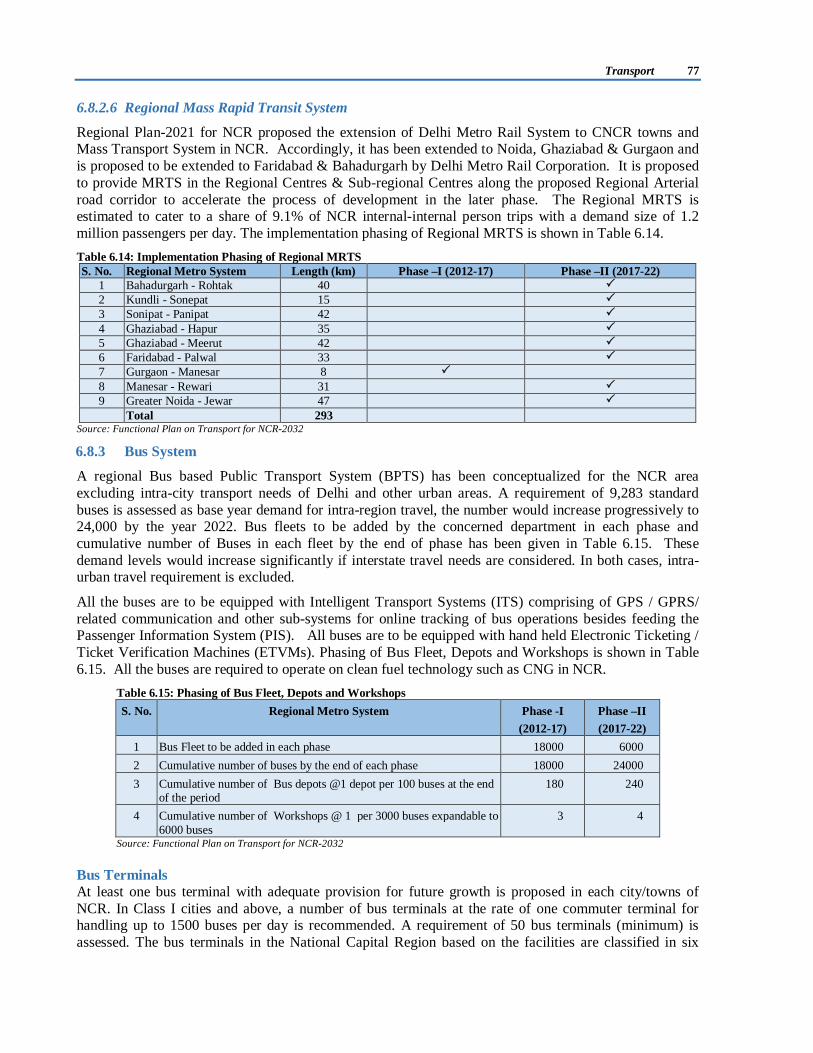
6.8.2.6 Regional Mass Rapid Transit System
Regional Plan-2021 for NCR proposed the extension of Delhi Metro Rail System to CNCR towns and Mass Transport System in NCR. Accordingly, it has been extended to Noida, Ghaziabad & Gurgaon and is proposed to be extended to Faridabad & Bahadurgarh by Delhi Metro Rail Corporation. It is proposed to provide MRTS in the Regional Centres & Sub-regional Centres along the proposed Regional Arterial road corridor to accelerate the process of development in the later phase. The Regional MRTS is estimated to cater to a share of 9.1% of NCR internal-internal person trips with a demand size of 1.2 million passengers per day. The implementation phasing of Regional MRTS is shown in Table 6.14. Table 6.14: Implementation Phasing of Regional MRTS S. No. Regional Metro System Length (km) Phase –I (2012-17) Phase –II (2017-22)
1 Bahadurgarh - Rohtak 40 2 Kundli - Sonepat 15 3 Sonipat - Panipat 42 4 Ghaziabad - Hapur 35 5 Ghaziabad - Meerut 42 6 Faridabad - Palwal 33 7 Gurgaon - Manesar 8 8 Manesar - Rewari 31 9 Greater Noida - Jewar 47
Total 293 Source: Functional Plan on Transport for NCR-2032
6.8.3 Bus System
A regional Bus based Public Transport System (BPTS) has been conceptualized for the NCR area excluding intra-city transport needs of Delhi and other urban areas. A requirement of 9,283 standard buses is assessed as base year demand for intra-region travel, the number would increase progressively to 24,000 by the year 2022. Bus fleets to be added by the concerned department in each phase and cumulative number of Buses in each fleet by the end of phase has been given in Table 6.15. These demand levels would increase significantly if interstate travel needs are considered. In both cases, intra-urban travel requirement is excluded.
All the buses are to be equipped with Intelligent Transport Systems (ITS) comprising of GPS / GPRS/ related communication and other sub-systems for online tracking of bus operations besides feeding the Passenger Information System (PIS). All buses are to be equipped with hand held Electronic Ticketing / Ticket Verification Machines (ETVMs). Phasing of Bus Fleet, Depots and Workshops is shown in Table 6.15. All the buses are required to operate on clean fuel technology such as CNG in NCR.
Table 6.15: Phasing of Bus Fleet, Depots and Workshops S. No. Regional Metro System
Phase -I
(2012-17) Phase –II (2017-22)
1 Bus Fleet to be added in each phase 18000 6000 2 Cumulative number of buses by the end of each phase 18000 24000 3 Cumulative number of Bus depots @1 depot per 100 buses at the end
of the period 180 240
4 Cumulative number of Workshops @ 1 per 3000 buses expandable to 6000 buses
3 4
Source: Functional Plan on Transport for NCR-2032
Bus Terminals At least one bus terminal with adequate provision for future growth is proposed in each city/towns of NCR. In Class I cities and above, a number of bus terminals at the rate of one commuter terminal for handling up to 1500 buses per day is recommended. A requirement of 50 bus terminals (minimum) is assessed. The bus terminals in the National Capital Region based on the facilities are classified in six

78 Regional Plan 2021
categories. The details of type of bus terminals required with respect to city size along with the six categories are as presented in Annexure 6/IV.
6.8.4 Air Transport
Indira Gandhi International Airport (IGIA), Delhi is the only commercial airport serving NCR. It is the second biggest in the country, handling a passenger traffic of 35.88 million per annum and cargo traffic of 0.56 million tonnes per annum. IGIA development, operation and management have been privatized. Air traffic is increasing at a high rate and it is estimated that Delhi airport would handle 82.7 million passengers by 2026. Based on the future growth of International Air traffic, a second International Airport in NCR may be developed.
Smaller Airports
NCR being a high activity area, there is a scope for developing smaller airports in some of the major urban centres within it. These would facilitate movement of smaller private aircrafts. The potential districts are Meerut, Rewari, Alwar, Rohtak, Sonepat and Panipat. Moreover, Airport Authority of India has conveyed site clearance for a Cargo Airport at Meham in Haryana.
6.8.5 Inland Water Transport (IWT)
Participating State Governments of NCR may explore the possibility of Inland Water Transport (IWT) in the suitable navigation channels in NCR, which may be used for bulk movement of goods. Possibility of passenger movement may be explored in the navigable channels. Transit points may also be identified at the places which have proper accessibility.
6.8.6 Intra-city Urban Transport
In order to cater to increasing demand of intra-urban traffic in towns, Mass Transport System for commuters such as Light Rail Transit System (LRTS) and Bus Rapid Transit System (BRTS) with a provision for feeder system should be provided in the cities having population of 10 lakh and above, while Metro Rail and Monorail may be provided in the cities having population of 20 lakh and above. The other Public Transport Systems may also be considered based on their feasibility. The State Government should adopt recommendations of Working Group on Urban Transport for 12th Five Year Plan for selecting suitable Mass Rapid Transit Mode. The norms and guidelines of Ministry of Urban Development for bus specifications should also be considered for bus system.
Delhi Mumbai Industrial Corridor Development Corporation Limited (DMICDC) has proposed 130.65 km MRTS to connect Gurgaon with Bawal.
6.8.7 Multimodal Integration
In NCR, about 190 km of Metro Rail is operational and about 136 km is under execution. In addition, about 381 km of high speed Commuter Regional Rapid Transit System (RRTS) is at implementation stage. All the systems are required to be integrated with each other as well as with long distance trains, bus services, taxis, etc. Therefore, improved intermodal connectivity is crucial for sustainable transport and passenger patronage. The primary reason for the widespread use of private car is its ability to provide first mile and last mile connectively despite the problems of traffic congestion and high cost of transport, hence can be curbed by providing multimodal integration in true sense which provides choice for passenger of zero distance interchange from one mode to any other mode ranging from high speed regional transit systems to bicycles. The success of inter modal culture depends on how seamless the modal shift can be made. There is a growing recognition that the sustainable mobility is about inter-connecting transport systems which have to provide a door to door service.
The provision of all modes of transport at a station give passengers choice to travel according to their need and at the same time reduces the pressure on one particular mode. It reduces spill-over of passengers to the adjoining areas and discourages informal transport activities. Multimodal integrated stations should
Transport 79
essentially include areas for parking of private modes as well as non motorised transport and Intermediate Public Transport such as auto rickshaws. In order to Plan and develop a Multimodal Station/Hub, it is imperative to consider all modes of transport, address existing & future needs, consider Station Access in all route alignments, integrate community design into station development, provide unified fare collection system and coordinate station design with land development. As there are multiple agencies for implementation of various modes of travel, it is proposed that they should come together to develop multimodal hubs even if they require minor modifications in the existing alignments. Land owning agencies while allocating land for these purposes should also emphasise on integration of all modes.
6.8.8 Transit Oriented Development (TOD) Transit Oriented Development (TOD) should focus around transit nodes. The facilities should be such that they provide complete ease of access to the transit facility, thereby encouraging people to prefer walking and using public transport over personal modes of transport. The Master/ Development Plans should identify potential TOD zones and promote development which enhances the use of transit facility. TOD should have the following components:
i. Pedestrian and Non-Motorised Transport (NMT) friendly environment.
ii. Create dense networks of streets and paths for all modes.
iii. Mass transportation modes serving the area should be well integrated to provide rapid and comfortable modal transfers.
iv. Modal Shift Measures should be adapted by using technology, regulating road use, parking and fiscal incentives.
v. High Density, Compact, Mixed-Use development should be encouraged to facilitate shorter and less number of trips.
vi. Emphasis should be to recover part cost of the transport network from TOD project.
Each city presents a unique context for creating TOD prototypes.
6.8.9 Environmental Concerns
Spatial distribution of Air pollution, (SPM, CO, NOx, RSPM) and Noise Pollution, [Leq (Day) and Leq (Night) levels] measured at 82 identified locations (2007) indicate that the norm of these parameters was also exceeding at various locations varying between moderate to critical level of pollution. Further, the NCR Transport Modal predicted intensity of traffic, by modes and their speed in the horizon year. Volume of exhaust gases due to anticipated traffic was estimated using the modals and location-wise Air Pollution Indices (API) was calculated which varies from 0.66 to 1.67. It was estimated that a total of 15.52 Gg (15520 M Tons) of CO2 /day would be emitted at the 82 stations in NCR. It indicates that Transport Plan for NCR is required to be implemented in phased manner as proposed and if the rail based public transport system i.e. RRTS and Bus-based public transport system are not implemented in time-bound manner, it will have serious impact on Climate Change apart from affecting the health of the people in the Region. Hence, there is a dire need to construct/develop Integrated Multi-Modal Transport System in NCR with major emphasis on RRTS, Regional Orbital Rail Corridor, Inner Regional Orbital Rail Corridor and efficient & reliable bus services as public transport system.
6.8.10 Service Level Bench Mark
Ministry of Urban Development, Government of India has prepared Service Level Bench Mark for Urban Transport. These are available on the website of the Ministry. Similarly, UTTIPEC has prepared guidelines for Urban Street Design, street furniture and other related aspects.
80 Regional Plan 2021
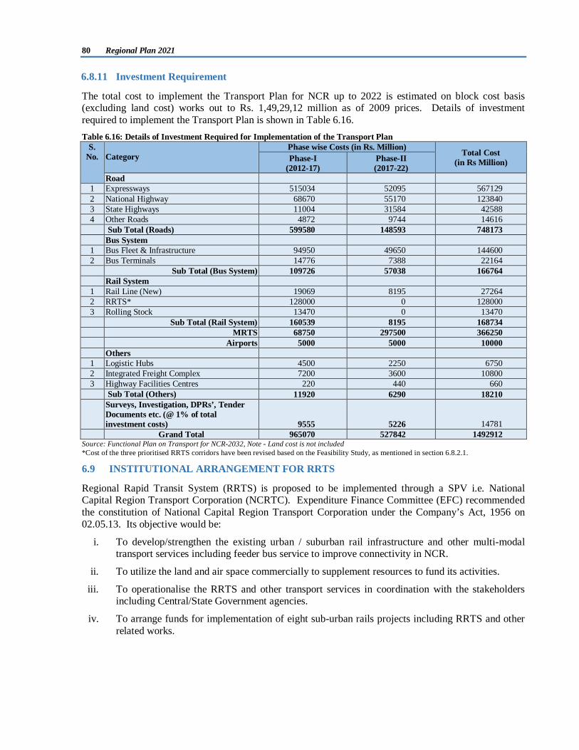
6.8.11 Investment Requirement
The total cost to implement the Transport Plan for NCR up to 2022 is estimated on block cost basis (excluding land cost) works out to Rs. 1,49,29,12 million as of 2009 prices. Details of investment required to implement the Transport Plan is shown in Table 6.16. Table 6.16: Details of Investment Required for Implementation of the Transport Plan
S. No. Category
Phase wise Costs (in Rs. Million) Total Cost (in Rs Million) Phase-I
(2012-17) Phase-II (2017-22)
Road 1 Expressways 515034 52095 567129 2 National Highway 68670 55170 123840 3 State Highways 11004 31584 42588 4 Other Roads 4872 9744 14616 Sub Total (Roads) 599580 148593 748173 Bus System 1 Bus Fleet & Infrastructure 94950 49650 144600 2 Bus Terminals 14776 7388 22164 Sub Total (Bus System) 109726 57038 166764 Rail System 1 Rail Line (New) 19069 8195 27264 2 RRTS* 128000 0 128000 3 Rolling Stock 13470 0 13470 Sub Total (Rail System) 160539 8195 168734 MRTS 68750 297500 366250 Airports 5000 5000 10000 Others 1 Logistic Hubs 4500 2250 6750 2 Integrated Freight Complex 7200 3600 10800 3 Highway Facilities Centres 220 440 660
Sub Total (Others) 11920 6290 18210 Surveys, Investigation, DPRs’, Tender
Documents etc. (@ 1% of total investment costs) 9555 5226 14781
Grand Total 965070 527842 1492912 Source: Functional Plan on Transport for NCR-2032, Note - Land cost is not included *Cost of the three prioritised RRTS corridors have been revised based on the Feasibility Study, as mentioned in section 6.8.2.1.
6.9 INSTITUTIONAL ARRANGEMENT FOR RRTS
Regional Rapid Transit System (RRTS) is proposed to be implemented through a SPV i.e. National Capital Region Transport Corporation (NCRTC). Expenditure Finance Committee (EFC) recommended the constitution of National Capital Region Transport Corporation under the Company’s Act, 1956 on 02.05.13. Its objective would be:
i. To develop/strengthen the existing urban / suburban rail infrastructure and other multi-modal transport services including feeder bus service to improve connectivity in NCR.
ii. To utilize the land and air space commercially to supplement resources to fund its activities.
iii. To operationalise the RRTS and other transport services in coordination with the stakeholders including Central/State Government agencies.
iv. To arrange funds for implementation of eight sub-urban rails projects including RRTS and other related works.
Transport 81
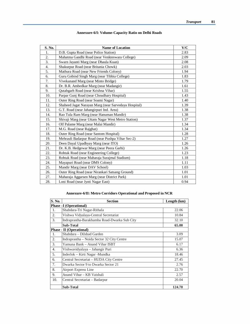
Annexure-6/I: Volume-Capacity Ratio on Delhi Roads
Annexure-6/II: Metro Corridors Operational and Proposed in NCR
S. No. Name of Location V/C 1. D.B. Gupta Road (near Police Station) 2.83 2. Mahatma Gandhi Road (near Venkteswara College) 2.09 3. Swarn Jayanti Marg (near Dhaula Kuan) 2.08 4. Shakurpur Road (near Britania Chowk) 2.03 5. Mathura Road (near New Friends Colony) 1.94 6. Guru Gobind Singh Marg (near Tibbia College) 1.83 7. Vivekanand Marg (near Minto Bridge) 1.79 8. Dr. B.R. Ambedkar Marg (near Madangir) 1.61 9. Qutabgarh Road (near Krishna Vihar) 1.55 10. Parpar Gunj Road (near Choudhary Hospital) 1.43 11. Outer Ring Road (near Soami Nagar) 1.40 12. Shaheed Jagat Narayan Marg (near Sarvodaya Hospital) 1.39 13. G.T. Road (near Jahangirpuri Ind. Area) 1.38 14. Rao Tula Ram Marg (near Hanuman Mandir) 1.38 15. Shivaji Marg (near Uttam Nagar West Metro Station) 1.37 16. Olf Palame Marg (near Malai Mandir) 1.34 17. M.G. Road (near Rajghat) 1.34 18. Outer Ring Road (near Santom Hospital) 1.28 19. Mehrauli Badarpur Road (near Pushpa Vihar Sec-2) 1.27 20. Deen Dayal Upadhyay Marg (near ITO) 1.26 21. Dr. K.B. Hedgewar Marg (near Peera Garhi) 1.26 22. Rohtak Road (near Engineering College) 1.23 23. Rohtak Road (near Maharaja Surajmal Stadium) 1.18 24. Mayapuri Road (near DMS Colony) 1.11 25. Mandir Marg (near DAV School) 1.03 26. Outer Ring Road (near Nirankari Satsang Ground) 1.01 27. Maharaja Aggarsen Marg (near District Park) 1.01 28. Loni Road (near Jyoti Nagar East) 0.94
S. No. Section Length (km) Phase –I (Operational) 1. Shahdara-Tri Nagar-Rithala 22.06 2. Vishwa Vidyalaya-Central Secretariat 10.84 3. Indraprastha-Barakhamba Road-Dwarka Sub City 32.10
Sub-Total 65.00 Phase - II (Operational) 1. Shahdara – Dilshad Garden 3.09 2. Indraprastha – Noida Sector 32 City Centre 15.07 3. Yamuna Bank – Anand Vihar ISBT 6.17 4. Vishwavidyalaya – Jahangir Puri 6.36 5. Inderlok – Kirti Nagar -Mundka 18.46 6. Central Secretariat – HUDA City Centre 27.45 7. Dwarka Sector 9 to Dwarka Sector 21 2.76 8. Airport Express Line 22.70 9. Anand Vihar – KB Vaishali 2.57 10. Central Secretariat – Badarpur 20.04
Sub-Total 124.70

82 Regional Plan 2021
Source: DMRC and State Governments
Annexure-6/III : Details of Completed Transport Sector Projects through NCRPB Funding in NCR S.
No. Name of the Projects S.No. Name of the Projects
HARYANA 1 Widening of Badkhal - Surajkund road, Faridabad
20. Project for widening and Strengthening to 10 m. of Hodal Nuh Pataudi Patauda road km. 0 to 96.20 up NH-71 (MDR No. 132)
2 Construction of external link road connecting with sector 17, Gurgaon
21. Four laning, widening and strengthening of Gurgaon-Nuh-Rajasthan Border (SH-13) (Km 7+20 to 95+89)
3 Widening & strengthening of existing Mehrauli road from National Highway 8 to Gurgaon - Delhi border, Gurgaon
22. Improvement of Sampla Jhajjar Road (SH 20) (Km 44.12 to km 65.46)
4 Widening & strengthening of Old Delhi Road from Dundahera border to National Highway 8, Gurgaon
23.
Improvement of Sonepat-Kharkhoda-Sampla Road (SH 20) (Km 10.125 to km 43.4)
5 Up-gradation of Roads in the NCR (Palwal & Nuh) 24. Widening and Up gradation of Rai Nahra Bahadurgarh Road (MDR 138) ( Km 0 to 37.4)
6 Construction of Transport Nagar at Panipat 25. Improvement (4 laning) of Murthal Sonepat Road (SH 20) (Km 0.0 to km 10.125)
7 Construction of Road from Northern Bye-pass Rohtak to NH-71 in Rohtak district
26. Improvement of Punhana to Jurhera Road Km. 0.00 to Km. 6.78 in Mewat District, Haryana.
8 Widening of road from NH-71 to NH-10 via Singhpura Kalan in Rohtak district
RAJASTHAN
9 Construction of 2 lane ROB at Km 60/6-7 near Hailly Mandi Kulana Road on Delhi- Rewari Section
Transport Nagar scheme part 'B', Alwar
10 Construction of 2 lane ROB at Km 31/8-9 on Delhi Rewari Railway Line on Gurgaon Daulatabad Section
27. Construction of RoB, Alwar
11 Construction of 2 lane ROB on Delhi Rewari Section at crossing of Gurgaon Farrukhnagar Jhajjar road at Gurgaon.
28. Construction of truck terminal, Alwar
12 Construction of two lane ROB at Delhi- Bhatinda Railway line and Rohtak Gohana Panipat Railway Line, Rohtak
29. Jindoli Ghati Bypass Tunnel, Alwar - Bharatpur road, district Alwar
13 Construction of 4 lane ROB on Delhi- Bhatinda Railway line at km 89.7
30. Development and construction of 9 km stretch of Dharuhera -Bhiwadi road
14 Construction of 2 lane ROB on Delhi-Bhatinda railway line at Rohtak
UTTAR PRADESH
15 Construction of Bypass in Kharkhoda in Sonepat district
Improvement of road network, Meerut
16 Construction of 2 lane ROB at Bahadurgarh on Delhi Bhatinda Railway line crossing
31. Improvement or road network, Ghaziabad
17 Improvement of Jahazgarh-Chhuchhakwas-Dadri Road (SH20)(Km 73.10 to Km 95.15)
32. NOIDA - Greater NOIDA expressway
Phase –III (Under Execution) 1. Jahangirpuri-Badli 4.49 2. Central Sectt.-Mandi House-Kashmere Gate 9.37 3. Mukundpur-Dhaula Kuan-Anand Vihar-Gokul Puri 55.29 4. Janakpuri West-Munirka-Kalkaji-Kalindi Kunj 33.93 5. Badarpur-YMCA Chowk, Faridabad 13.88 6. Gokul Puri-Shiv Vihar 2.72 7. Dwarka-Najafgarh 5.50 8. Mundka-City Park, Bahadurgarh 11.13
Sub-Total 136.31 Other Metro Proposals in NCR 1. Rapid Metro Rail in Gurgaon (under execution) 12.10 2. Noida Sector 32 - Boraki Railway Station, Gr. Noida (proposed) 29.00
Sub-Total 41.10 Grand Total 367.11

Transport 83
S. No. Name of the Projects S.No. Name of the Projects
18 Improvement of Gurgaon-Farrukhnagar- Jhajjar Road (SH 15A) (Km 5.5 to km 45.25)
CMAs
19. Improvement of Rohtak-Kharkhoda Delhi Road (SH 18) (Km 10.2 to km 40.76)
33. Construction of 6 lane Arterial Road in CMA Gwalior.
Source: NCRPB
Annexure-6/IV : Categorization of Bus Terminal based on Amenities and city size S.
No. Amenities / Facilities Category of terminal / suitable for
class of city 1 Drinking water & Hand Pumps
Category ‘D’(1-6) “Class V level towns”
2 Lighting & passenger sheds & station 3 Fans in passenger sheds 4 Benches & chairs 5 Display of time table and fare list 6 Toilets and urinals 7 Suggestions/complaint box
Category ‘C1’(1-15) “ Block Level Facilities” or
“Class IV level cities”
8 Booking and enquiry counter 9 Canteen/book stalls/general merchant shops
10 Boarding platform 11 Stalls 12 PCO 13 Passenger lounge 14 Mini tube well and moulded tank 15 Idle parking 16 Public address systems
Category ‘C2’(1-18) “Class III level cities”
17 Water cooler 18 In-out enquiry 19 Generator
Category ‘B’ (1-22) “Class II level cities”
20 Administrative office 21 Driver/ conductors rest room 22 Private car, scooter rickshaw parking 23 Television
Category ‘A’(1-30) “Class I level cities”
24 AC canteen 25 AC waiting room 26 Dormitory 27 Computerized arrival/ departure 28 Computerized booking/reservation 29 Tube well & RCC overhead tank 30 Cloak room 31 Tourist information centre
Category ‘A plus’(1-35) “Metropolitan Cities”
32 Washing machine 33 Security room
34 Passenger Information system 35 Real Time Information System
Source: Functional Plan on Transport for NCR-2032
Suggested Operational and other facilities required in Bus Terminal w.r.t. city size
S. No. Description Population
Range
Type of Terminals Proposed Size of Terminals
(in acres)
Terminal classification on
the basis of amenities /
facilities
Inter-state
Intra-region
Urban Services
Other Services
1 State capitals and Metropolitan Cities >1000000 X 15 A+
2 Major city centers >500000 X 10-15 A 3 Class I settlements >100000 X X 10-15 A 4 Class II settlements 50000-99999 X X 5-10 B 5 Class III settlements 20000-49999 X 5 C2 6 Class IV settlements 10000-19999 X X 3 C1 7 Class V settlements 5000-9999 X X X 2 D
Source: Functional Plan on Transport for NCR-2032