EXECUTIVE SUMMARY Functional Plan on Transport for ...ncrpb.nic.in/pdf_files/Executive...
16
Functional Plan on Transport for National Capital Region-2032 xiv EXECUTIVE SUMMARY Functional Plan on Transport for National Capital Region-2032 1. Introduction National Capital Region Planning Board prepared the Regional Plan with the perspective year 2021 for the National Capital Region as per the provisions of Section 10 of the NCR Planning Board Act, 1985 for balanced and harmonized development of the National Capital Region which was notified on 17 th September, 2005. The Region covers an area of 33,578 square kilometres with 1,483 sq kms (or about 4.41%) falling in the National Capital Territory of Delhi; 13,413 sq kms (or about 39.95%) falling in the Haryana Sub-Region; 7,829 sq kms (or about 23.32%) falling in the Rajasthan Sub-Region; and 10,853 sq kms (or about 32.32%) falling in the Uttar Pradesh Sub-Region. It includes nine districts of Haryana, namely, Faridabad, Palwal, Gurgaon, Mewat, Rohtak, Sonepat, Rewari, Jhajjar and Panipat; five districts of Uttar Pradesh, namely, Meerut, Ghaziabad, Gautam Bhudha Nagar, Bulandshahr and Baghpat; and Alwar district of Rajasthan apart from NCT-Delhi. In addition to above, there are eight Counter-magnet Areas, namely, Ambala and Hissar in Haryana, Bareilly and Kanpur Nagar in Uttar Pradesh, Dehradun in Uttrakhand, Kota in Rajasthan, Patiala in Punjab and Gwalior in Madhya Pradesh. One of the objectives of the Regional Plan-2021 is to provide efficient and economic rail and road based transportation system (including mass transport systems) well integrated with the landuse patterns for balanced regional sustainable development. National Capital Region Planning Board (NCRPB) initiated preparation of an Integrated Multi Modal Transport Plan (IMMTP) for NCR to be in consonance and within the policy framework of the Regional Plan. The study was carried out by M/s Consulting Engineering Services (India) Private Limited, New Delhi. On submission of the Draft Final Report, a workshop was organized on 02 February 2009, at India Habitat Centre, New Delhi, wherein stakeholders, experts and members of Planning Committee, Task Force, Advisory Group and Consultancy Review Committee were invited to interact and obtain their suggestions on the Plan. The Final Report presents the findings of the surveys & studies, the policy framework and details the Integrated Multi Modal Transport Plan for NCR. The Functional Plan on Transport-2032 for NCR has been prepared based on the findings and recommendations of this Study Report and as per the provisions of section 16 of the NCR Planning Board Act, 1985. 2. NCR Transport System NCR transport system includes an extensive road network system of about 36,305 km; a large bus fleet, a good rail network of about 1000 km; and an International Airport at Delhi. 3. Surveys and Studies A large number of extensive and in-depth surveys and studies were carried out to appreciate the characteristics of NCR and identify issues, constraints and opportunities which includes Road Network Inventory; Speed & Delay Survey of 2950 kms; Classified Traffic Volume Count Survey at 82 locations (3- day Traffic Volume Count at 22 locations and 1-day Traffic Volume Count at 60 locations); Origin - Destination Survey at 43 locations; Commuter Survey (5156 samples); Environmental Status Survey at 20 locations; Bus Terminal Survey at 20 terminals; Stated Preference Survey (748 samples); Freight Operator Survey (100 samples); Social Impact Survey along major corridors and Intermediate Public Transport Survey (198 samples).
Transcript of EXECUTIVE SUMMARY Functional Plan on Transport for ...ncrpb.nic.in/pdf_files/Executive...

Functional Plan on Transport for National Capital Region-2032
xiv
EXECUTIVE SUMMARY
Functional Plan on Transport for National Capital Region-2032
1. Introduction National Capital Region Planning Board prepared the Regional Plan with the perspective year 2021 for the National Capital Region as per the provisions of Section 10 of the NCR Planning Board Act, 1985 for balanced and harmonized development of the National Capital Region which was notified on 17th September, 2005. The Region covers an area of 33,578 square kilometres with 1,483 sq kms (or about 4.41%) falling in the National Capital Territory of Delhi; 13,413 sq kms (or about 39.95%) falling in the Haryana Sub-Region; 7,829 sq kms (or about 23.32%) falling in the Rajasthan Sub-Region; and 10,853 sq kms (or about 32.32%) falling in the Uttar Pradesh Sub-Region. It includes nine districts of Haryana, namely, Faridabad, Palwal, Gurgaon, Mewat, Rohtak, Sonepat, Rewari, Jhajjar and Panipat; five districts of Uttar Pradesh, namely, Meerut, Ghaziabad, Gautam Bhudha Nagar, Bulandshahr and Baghpat; and Alwar district of Rajasthan apart from NCT-Delhi. In addition to above, there are eight Counter-magnet Areas, namely, Ambala and Hissar in Haryana, Bareilly and Kanpur Nagar in Uttar Pradesh, Dehradun in Uttrakhand, Kota in Rajasthan, Patiala in Punjab and Gwalior in Madhya Pradesh.
One of the objectives of the Regional Plan-2021 is to provide efficient and economic rail and road based transportation system (including mass transport systems) well integrated with the landuse patterns for balanced regional sustainable development. National Capital Region Planning Board (NCRPB) initiated preparation of an Integrated Multi Modal Transport Plan (IMMTP) for NCR to be in consonance and within the policy framework of the Regional Plan. The study was carried out by M/s Consulting Engineering Services (India) Private Limited, New Delhi. On submission of the Draft Final Report, a workshop was organized on 02 February 2009, at India Habitat Centre, New Delhi, wherein stakeholders, experts and members of Planning Committee, Task Force, Advisory Group and Consultancy Review Committee were invited to interact and obtain their suggestions on the Plan. The Final Report presents the findings of the surveys & studies, the policy framework and details the Integrated Multi Modal Transport Plan for NCR. The Functional Plan on Transport-2032 for NCR has been prepared based on the findings and recommendations of this Study Report and as per the provisions of section 16 of the NCR Planning Board Act, 1985. 2. NCR Transport System NCR transport system includes an extensive road network system of about 36,305 km; a large bus fleet, a good rail network of about 1000 km; and an International Airport at Delhi. 3. Surveys and Studies A large number of extensive and in-depth surveys and studies were carried out to appreciate the characteristics of NCR and identify issues, constraints and opportunities which includes Road Network Inventory; Speed & Delay Survey of 2950 kms; Classified Traffic Volume Count Survey at 82 locations (3- day Traffic Volume Count at 22 locations and 1-day Traffic Volume Count at 60 locations); Origin - Destination Survey at 43 locations; Commuter Survey (5156 samples); Environmental Status Survey at 20 locations; Bus Terminal Survey at 20 terminals; Stated Preference Survey (748 samples); Freight Operator Survey (100 samples); Social Impact Survey along major corridors and Intermediate Public Transport Survey (198 samples).

Functional Plan on Transport for National Capital Region-2032
xv
4. Road Network NCR has a good road network system. The road density is 108 km/100 Sq. km, which is higher than the national road density. The accessibility levels are good with NCT-Delhi having the highest accessibility. Connectivity is also good. Mobility index indicates the need for improving the quality of the road network. 5. Traffic Volume NCR is a high movement area and high intensity traffic of all types move on the road network. 2,21,575 vehicles (3,50,694 PCUs) enter and exit NCR (outer cordon – OC) on an average per day. National Highways account for 74.75% (vehicles) of the total traffic volume. The traffic volume increases to 2,72,891 vehicles (3,87,565 PCUs) at the Middle Cordon – (MC) around the CNCR area; and reaches a high of 12,10,896 vehicles (12,27,873 PCUs) at Inner Cordon – (IC) around NCTD. 6. Traffic and Travel Characteristics The traffic pattern in the NCR presents interesting features. At the Outer Cordon, nearly 97% of passenger modes movement was Internal – External and External – Internal. Only 3.2% was External – External (non destined). The inter-spatial movement pattern of passenger modes showed a high share between ‘Rest of NCR’ and ‘Outside NCR’ areas. Of the goods modes movement at Outer Cordon, 9.1% was non-destined. At the Middle Cordon, Internal-External and External-Internal passenger mode movement accounted for 68.6%. The share of through movement was 4.1%. A high intensity of interaction between CNCR and outside areas was observed. Internal-Internal passenger movement was 27.3% within CNCR. Of the goods modes, 7.2% was non-destined. At the Inner Cordon, of the passenger modes, the non-destined traffic was a high of 12.9%; and of goods modes, 29.9%. 7. Rail System NCR has a good rail network system with 5 Divisions of 3 Zonal Railways. Three rail corridors converge at Ghaziabad and six rail corridors converge at Delhi. They are Ghaziabad – Khurja, Ghaziabad – Hapur – Garmukteshwar & Ghaziabad – Meerut and Delhi – Ghaziabad, Delhi (Shahadara) – Shamli – Saharanpur, Delhi – Faridabad – Palwal – Mathura, Delhi – Gurgaon – Rewari – Alwar, Delhi – Shakurbasti – Rohtak and Delhi – Subzimandi – Sonipat – Panipat. A large number of long distance passenger trains, commuter suburban trains and goods trains move into and out of NCR. The commuter traffic in NCR is about 0.61 million per day. 8. Air Transport Indira Gandhi International Airport (IGIA) is the major airport in NCR. In terms of traffic volumes, it is second to Mumbai, and handles annually about 20.44 million passengers and 0.39 million tons of cargo traffic (2006-07). Air traffic is increasing at a high rate and it is forecasted that Delhi airport would handle 82.7 million passengers by 2026 and would touch 100 million by 2036. Of the passenger traffic, 75.75% was generated within NCTD, 18.75% in NCR (excluding NCTD) and 5.50% beyond NCR.

Functional Plan on Transport for National Capital Region-2032
xvi
9. Bus System NCR is served by an extensive bus service operated by STUs of NCTD, Haryana, Uttar Pradesh, Rajasthan, Uttaranchal, Punjab, Himachal Pradesh and Jammu and Kashmir; and a host of private operators. The STUs operated about 3144 buses from NCR depots and carried 1.05 million passengers per day. The overall NCR bus density (number of buses per lakh people) is much higher (132) compared to national density (71) in the year 2004. The physical performance of the bus system (STUs) in NCR is good. However the financial performance is poor, leading to a loss of Rs 22.94 per bus km. The demand for buses in NCR would continue to increase at a high rate and it is estimated that by 2032, more than 37,000 buses will be required to cater to the demand.
10. Intermediate Public Transport System (IPTS) A large number of auto rickshaws and taxis operate within NCR providing the much needed capacity and service. However this operation is mainly intra urban. The operation (driving) is mostly by hired vehicles (72%). An auto rickshaw carries 96 passengers per day and other vehicles carry 114 passengers per day on an average. The IPTS suffers from many constraints like lack of terminal facilities, technological obsolescence, uneconomic fares, harassment, etc. There is a need to facilitate growth and operation of IPTS within the NCR. 11. NCR Transport Modal, Development Scenario, Transport Network Alternatives, Recommended Alternative for NCR and Trip Forecast
A four stage Urban Transport Planning System (UTPS) modal has been constructed for modalling internal-internal trips and an elasticity based growth rate modal for the other three components of trips (IE, EI & EE). The transport network comprises the road network, public transport (bus & rail) and metro network. Nearly 5.9 million person trips are performed daily by road in the base year, of which 3.9 million trips are I-I. In terms of freight traffic, nearly 1.8 million tonnes move daily in the study area.
Regression modals based on zonal population and employment, for passenger trip production and attraction have been developed for intra-region trips, for various spatial components of NCR namely, rural, urban, service centre, sub regional centres and metro centres & regional centres. For NCTD, trip rate modal has been adopted.
The trip distribution is accomplished using gravity modal where the generalised cost used is the composite impedance represented by a logsum variable. The modal is calibrated using CUBE Voyager software wherein friction factor lookup table is generated. The validation was performed using checks such as trip length frequency distribution, coincidence ratio and mean trip length.
A nested logit choice modal was developed for mode choice modalling based on Stated Preference and Revealed Preference data. The modal was calibrated separately for five different spatial units: NCT Delhi, NCR Urban Service Centres, NCR Urban Sub Regional Centres, NCR Urban Metro and Regional Centres and NCR Rural. The attributes considered were travel time, travel cost and wait time for transit modes and travel time and cost for private modes. The estimation of the choice modal process comprised setting up of panel data, calibration of coefficients and modal bias from disaggregate modal and validating the same at disaggregate level. Maximum likelihood method was adopted to estimate the modal parameters. The modal was successfully validated by comparing the observed and estimated trips by different modes across various spatial stratification in NCR. Modal sensitivity tests were also carried out in terms of change in fare and time of bus and rail on their respective riderships.

Functional Plan on Transport for National Capital Region-2032
xvii
Trip assignment was carried out using Capacity Restraint Assignment Technique. The highway assignment was carried out for the peak period, preloading the network with public transport and commercial vehicle flows before loading the private vehicle flows. While the highway assignment was carried out based on generalised cost (with vehicle operating cost and value of time as inputs), the public transport assignment was based on generalised time (with in-vehicle travel time, waiting time and fare in time units as inputs). The validation of the trip assignment was done by comparing the assigned with the observed screen line traffic counts. Five alternate land use development scenarios were conceptualised based on alternate policies and patterns of development. Planning variables in terms of population and employment were forecast for various spatial stratifications of NCR for each development scenario. The calibrated trip end modals in the base year for daily person trips within the region were applied along with trip rates for NCT Delhi on projected population development scenario to get future trip ends. The inter-region traffic was forecasted based on elasticity approach. Transport demand elasticities were worked out based on time series information and projected in the horizon years along with projected NSDP growth rates in the horizon years which provided the estimates of future inter-region traffic. The horizon year trip end forecasts incorporating inter and intra-region trips ranges from 18.3 million to 23.77 million in different scenario in the Horizon Year 2032 for passenger traffic while it varies between 5.87 million tonnes to 6.57 million tonnes for goods traffic.
Regional Plan-2021 has estimated the population size of NCR, by 2021, to be 64.14 million. As the Transport Plan is being envisaged for 2032, the population and employment data of NCR, extended up to 2032, are estimated to be 86.67 million and 32.67 million, respectively. Five scenarios of spatial distribution of population and employment by three policy zones of NCTD, CNCR and Rest of NCR, were conceptualized in the study which includes:
Growth Trend Based Development NCR – RP-2021 Policy Based Development Dominant Delhi Based Development Strong CNCR Based Development Strong ‘Rest of NCR’ Based Development
Distribution of employment size, by spatial zones, in different policy zones, was estimated under similar policy basis and comparative distribution of population & employment in policy zones, by 2032, were depicted in the study. Five alternate Transport Networks were conceptualized in the study in consonance with the Development scenarios. Combining the five Development Scenarios and five Network Alternatives, a scenario matrix was generated with 25 cells of different combinations, out of which six combinations were selected for evaluation and selection. The probable scenario was evaluated and ranked in the Study which was carried out by i) graphical indices and ii) analytical quantitative indices. Graphical indices include Accessibility Index, Mobility Index and Degree of Connectivity. The analytical quantitative index (outputs / impacts) includes the following:
Passenger vehicles-kilometers by modes (car, 2-wheeler, bus, rail and metro)
Passenger vehicle-hours by modes
Goods tonnage – kms Goods tonnage-hours Energy (fuel) consumption by modes (Car,

Functional Plan on Transport for National Capital Region-2032
xviii
Person kilometers by modes Person hours by modes Goods vehicle-kms Goods vehicle-hours
2-wheeler, Auto Rickshaw & Goods vehicles)
Emissions (CO2) by modes
Under both the techniques, the combination scenario ‘Strong Rest of NCR – Integrated Multi Modal Transport System’ emerged as the most optimal and the scenario ‘RP 2021 (extended) – Integrated Multi Modal Transport System’ was the second best. This indicates the importance of the ‘Rest of NCR’ zone for future development to receive larger population and activities. However, the scenario combination RP 2021 Extended – Integrated Multi Modal Transport System – was selected for detailing. The conceptual transport network system is the same in both the scenarios. Using the NCR Transport Modal, travel demand in the Horizon Year was estimated in the Study. Horizon year traffic assignment was carried out for public and private trips on respective networks. Iterative process between public transport and private traffic assignment was carried out until there was no appreciable change in the link loadings and link cost.
12. NCR – Integrated Multi Modal Transport Plan
Based on the selected scenario, the Integrated Multi Modal Transport Plan (IMMTP) for NCR has been prepared. The Plan emphasizes on two aspects, namely, Integration and Multi-Modality. The Network Plan provides for physical integration. Operational integration needs to be ensured while detailing the operational plan of the component systems.
The NCR – IMMTP includes:
An extensive network of Regional Expressways (1376 kms) An extensive network of Regional Arterials (1801 kms)
(which are the strengthened National Highways and upgraded State Highways) An extensive network of Regional Sub-Arterials (631 kms) (which are the strengthened State Highways and upgraded Major District Roads) An extensive network of Regional Collectors/Distributors (which are the strengthened Major District Roads and upgraded Other District Roads) An extensive network of Sub-Regional Access Roads (which are the Other District Roads and Village Roads to be detailed in Sub-Regional Plans) An extensive Bypass system around the regional urban centres A large number interchanges on the road network system A Network of Regional Rapid Rail System (RRTS) (640 kms) running on dedicated tracks and
providing rail service for commuters New Rail lines linking some of the regional centres and metro centres in the form of Regional Orbital
Rail Corridor (RORC) and Inner Regional Orbital Rail Corridor (IRORC) (561 kms) An extended network of Metro Rail System connecting the Regional Centres An extensive fleet of Bus System with supporting infrastructure (Depots, Workshops) A number of Bus Terminals and Rail Terminals enabling integration of and smooth transfer amongst
modes A number of Logistics Hubs A number of Highway Transport Facility Centers A number of Integrated Freight Complexes and Truck Terminals

Functional Plan on Transport for National Capital Region-2032
xix
A second International Airport and a number of small airports in a few of the Regional Centres The Map 0.1 presents the proposed NCR Transport Network System.
Road System
Road Network forms the main component of the IMMTP. A revised hierarchical classification comprising Regional Expressways, Regional Arterials, Regional Sub-Arterials, Regional Collectors / Distributors and Regional Access Roads is proposed. An extensive Regional Expressway Network extending over a length of 1245 km is proposed. These expressways will enhance the quality of the road system. High Occupancy Vehicle (HOV) lanes in Expressway and Regional Arterials need to be provided. Regional bypass system (connecting Panipat, Rohtak, Rewari, Palwal, Khurja, Hapur, Meerut, Panipat) is important to enable the high intensity inter region goods traffic to move at the regional level. The quality of the Regional Bypass must be better than radial expressways to facilitate the process of diversion. Differential fare policy, between radial & grid corridors and general & HOV lanes, needs to be adopted. The Kundli-Manesar-Palwal and Palwal-Ghaziabad-Kundli expressways are important, but would tend to become urban expressways due to intense urban development in CNCR. At the second level, the existing radial NH corridors converging into Delhi are proposed to be developed as Regional Arterials. NCR-RP 2021 has recommended high intensity development along major highway corridors. Hence, these highways would almost become urban corridors with high intensity of traffic. Along the NCR-Road Network, a number of support facilities are suggested. They include development of Facilities Centers, Logistic Hubs and Integrated Freight Complexes. Regional Rail System
NCR has a good rail network system. A variety of movements take place on it. Commuter service is important for people within NCR. The rail commuter demand is estimated to be 1.7 million passengers per day. An extensive commuter survey network designated as Regional Rapid Transit System is proposed along dedicated tracks, with electrification and modern signal and communication systems to enable safe, high speed, high frequency services. The Regional Orbital Rail Corridor (RORC) connecting Panipat-Rohtak-Rewari-Palwal-Khurja-Hapur-Meerut-Panipat enables re-routing of national rail goods movements at the regional level avoiding Delhi Area. In this corridor Panipat-Meerut, Palwal-Khurja and Palwal-Bhiwadi-Rewari are new rail lines and Rohtak-Rewari rail line is under construction. Meerut-Khurja and Rohtak-Gohana-Panipat Corridors are existing corridors. RORC also interconnects the regional centers increasing their accessibility and potential for growth.

Functional Plan on Transport for National Capital Region-2032
xx
Map 0.1

Functional Plan on Transport for National Capital Region-2032
xxi
In addition to RORC, five other rail lines, within NCR, are proposed to strengthen the connectivity of the rail system which will form Inner Regional Orbital Rail Corridor (IRORC). They are Sonipat – Jhajjar, Jhajjar – Gurgaon, Gurgaon – Faridabad, Faridabad – Dadri, Meerut - Baghpat – Sonipat and Sonipat – Gohana – Jind. Sonipat – Gohana – Jind corridor is under execution. Dadri-Ghaziabad-Meerut connectivity would be available through RRTS Corridors. This will connect most of the metro centres and regional centres in NCR. The proposed two Dedicated Freight Corridors (DFCs) run through the region and meet at Dadri. In addition to the rail terminal at Dadri, a major logistics and container terminal is proposed to be developed at Dadri. Further, such terminals would also be developed at Khurja, Palwal, Rewari, Rohtak, Panipat and Meerut. NCR Transport Corporation under the Ministry of Urban Development is being proposed to develop and operate the RRTS. Regional Mass Rapid Transit System (MRTS) Regional Plan-2021 for NCR proposed the extension of Delhi Metro Rail System to CNCR towns and Mass Transport System in NCR. Accordingly, it has been extended to Noida and is proposed to be extended to Gurgaon, Ghaziabad, Faridabad, Bahadurgarh and Greater Noida by Delhi Metro Rail Corporation. The work on Gurgaon corridor is in progress. It is proposed to provide MRTS in the Regional Centres & Sub-regional Centres along the proposed Regional Arterial road corridor to accelerate the process of development in a later phase. The Regional MRTS is estimated to cater to a share of 9.1% of NCR internal-internal person trips with a demand size of 1.2 million passengers per day.
Bus System A regional Bus based Public Transport System (BPTS) has been conceptualized for the NCR area excluding intra-city transport needs of Delhi and other urban areas. At present, more than 6200 buses, mainly from 57 depots of the STUs located in the NCR, and others located outside, serve the intercity, inter and intra region transport needs of NCR. The bus system growth in the region has not kept pace with growth in travel demand. Against an average of 71 buses per lac persons country-wide, the NCR sub regions of Uttar Pradesh and Rajasthan have much lower densities with 46 and 43 buses respectively; Haryana has 64 and Delhi, 267. As per CES survey 2007, nearly 53% (50% by bus and 3% by mini bus) of all the motorised passenger trips are served by buses constituting 7.35% of all the passenger vehicle trips observed. The average trip length of intra region bus passengers is 51 kms, and the PCTR, 0.0479. A number of recommendations in respect of fleet size, fleet ownership, institutional set-up, bus depots, capacity building, bus terminals / BQS, rationalization of fares & taxes, bus technology, seamless integration of travel trips, etc. have been made for bus based public transport in the Multi-modal Integrated Transport System. On the basis of the current PCTR, the population of NCR and the bus capacity of 11673 seat kms daily, a requirement of 9283 standard buses is assessed as base year demand for intra region travel, the number increasing progressively to 37734 in the horizon year 2032. These demand levels would increase significantly if interstate travel needs are considered. This demand however

Functional Plan on Transport for National Capital Region-2032
xxii
has to be served both by the NCR as also by other States. In both cases, intra urban travel requirement is excluded. The induction of bus fleets - both on addition and replacement accounts and creation of bus depots and the Workshops, require a total investment of about Rs 25873 crores (at base year prices) spread over the period of 25 years. The investment in about 75% of the bus fleet additions, its periodic replacements and the corresponding bus depots and workshops would be made by the private sector through a PPP modal. Only about 25% of the investment amounting to nearly Rs 6468 crores is proposed to be made by the Government agencies. The above investment of Rs 6468 crores is expected to serve an average population of about 7 crores during the period of 25 years. Investment requirement by the Government agencies comes to Rs 37 lakhs per lakh population per year or Rs 37 per person per year. All buses are to be provided with electronic route-destination display system. All the buses are to be equipped with Intelligent Transport Systems (ITS) comprising of GPS / GPRS / related communication and other sub systems for on-line tracking of bus operations besides feeding the Passenger Information System (PIS). All buses are to be equipped with hand held Electronic Ticketing / Ticket Verification Machines (ETVMs). The ETVMs need to be GPS/ GPRS compatible for on-line identification of bus stops / fare stages and communication of requisite data (the way bill details, revenue collection, etc.) to the control rooms periodically. Bus Terminals
In a large region like NCR, passengers shift from one bus route to another, one transport mode to another, public transport buses to private transport buses to complete their end-to-end trips call for seamless transfer facilities in the form of bus terminals / bus stations, to avoid inconvenience to the passengers. Mode / route interchange facilities in the form of bus terminals/bus stations is an important factor influencing efficiency of bus transport system. For more than 6000 buses operating in the NCR, only a few terminal spaces have been provided. Even amongst these, except for some terminals, the rest are partially / poorly developed. A passenger bus terminal broadly needs to perform various functions to meet requirements of passengers and vehicles; passengers only; vehicles only; crew and the management. Considering the requirements, the facilities planned, and the population of the settlements, the bus terminals is to be classified. At least one bus terminal with adequate provision for future growth is proposed in every city. In Class I cities and above, a number of bus terminals at the rate of one commuter terminal for handling up to 1500 buses per day is suggested. A requirement of 50 bus terminals (minimum) is assessed. Development of bus terminals calls for large investments which are proposed to be obtained through Public-Private-Partnership (PPP), the public sector equity coming mainly as the land value of the bus terminals. A total investment of Rs 3539 crores for development of bus terminals across NCR is estimated. The investment is proposed to be made on PPP basis in a phased manner generally at the rate of 20%, 20%, 20% and 40% during the years 2008-12, 2013-2017, 2018-2022, 2023- 2032 respectively. Development of bus terminals and other facilities under the PPP modal, involves a large variety of activities. These are proposed to be performed by an independent agency under the over all control of the Government to avoid any bias between public and private bus operators.

Functional Plan on Transport for National Capital Region-2032
xxiii
Airports Indira Gandhi International Airport (IGIA), Delhi is the only commercial airport serving NCR. It is the second biggest in the country, handling a passenger traffic on 20.44 million per annum and cargo traffic of 0.39 million tonnes per annum. Of the passenger traffic, 75.75% is generated within NCTD, 18.75% in NCR excluding Delhi and 5.5% from outside NCR. IGIA development, operation and management has been privatized. It is estimated that IGIA will need to handle a traffic of 100 million passengers by 2036.
The Government of Uttar Pradesh have proposed development of a 2nd International Airport in Greater Noida (Jewar) named as Taj International Airport. The proposal is under active consideration of the Government of India. It is expected to handle about 40 million passengers per annum.
Considering the growing importance of air transport, facilitated by an enabling Civil Aviation Policy, the demand for air connectivity to and from the regional centres in NCR would increase. The national and business traffic generated by these centres would need quick access to and from the international airports. A number of smaller airports in a few of the major regional centres are proposed.
13. Environmental Impact Assessment
Air Pollution and noise level surveys were carried out at a number of locations within NCR by the Consultant and Air Pollution and Noise Modals constructed. Spatial distribution of SPM, CO, NOx, RSPM, Leq (Day) and Leq (Night) levels measured at 82 identified locations by the Consultant in the year 2007 have been detailed out following paras: SPM The CPCB standard for SPM is 200 µg/m3. It is clear that out of total 82 stations, SPM level at 34 Stations is below the prescribed standards (EF varies between 0.5-1.0; Moderate pollution) with varying magnitude. At 36 stations, it is violating the standards (EF varies between 1.0-1.5; High Pollution) with varying magnitude and at remaining 12 stations it is critical (EF >1.5;Critical Pollution). Preventive and control measures are required to be undertaken at 36 stations where it is violating norms. Twelve stations where SPM level is critical are: 19(Dasna Toll Plaza), 21(Near Dadri), 69(Bagadurgarh-Delhi), 62(NH-8 Behror), 20(Morta), 44(Bilaspur Toll Plaza), 23(Near Indrapuram, Ghaziabad), 42(Khirki Dola), 9(Kundli), 1(Babarpur), 26(Faridabad) and 22(Mohan Nagar) are violating the standards (EF >1.5;Critical Pollution) and immediate measures are required to be taken by the concerned authorities for its reduction.
CO
The CPCB standard for CO is 2000 µg/m3. It is clear that out of 82 stations, 72 stations are well below the prescribed standards (EF varies between 0.0-0.5; Low pollution) have a rather pristine air quality and such areas are to be maintained at low pollution level by way of adopting preventive and control measures of air pollution. In the remaining, 9 Stations though below the prescribed standards (EF varies between 0.5-1.0; Moderate pollution) with varying magnitude as of now are likely to exceed the standards in future. It is observed that the concentration of CO at station 22(Mohan Nagar) which is exceeding the standards (EF varies between 1.0 - 1.5; High Pollution), needs preventive and control measures to be taken.
NOx
The CPCB standard for Nox is 80 µg/m3. It is clear that out of 82 stations, 79 stations are well below the prescribed standards (EF varies between 0.0-0.5; Low pollution) have a rather pristine air quality. The
Functional Plan on Transport for National Capital Region-2032
xxiv
remaining 3 stations, 44(bilaspur Toll Plaza), 9(Kundli) and 1 Babarpur are below the prescribed standards (EF varies between 0.5-1.0; Moderate pollution) with varying magnitude as of now but likely to exceed the standards in future. RSPM
The CPCB standard for RSPM is 100 µg/m3. It becomes clear that among all 82 stations, RSPM levels of 46 stations are below the prescribed standards (EF varies between 0.5-1.0; Moderate pollution) with varying magnitude as of now but likely to violate the standards in future. In the remaining, 26 stations which are violating the standards (EF varies between 1.0-1.5; High Pollution) with varying magnitude, preventive and control measures are to be taken. It is observed that the concentration of RSPM at Station 69(Bahadurgarh – Delhi),62(NH-8 Behror),20(Morta) 44(Bilaspur), 23( Indrapuram), 42(Khirki Dola), 9(Kundli), 1( Babarpur), 26(Faridabad) and 22(Mohan Nagar) are violating the standards(EF >1.5;Critical Pollution), where preventive and control measures have to be taken immediately.
In order to assess the noise impacts due to the proposed project on surrounding area base line noise levels were monitored. To determine the existing noise level, field monitoring was carried out along the existing alignment of the road with integrating sound level meter as per IS: 3029-1980. Leq (Day)
The CPCB standard for Leq (Day) is 65 dB (A). It becomes clear that all 82 stations are above the prescribed standards. It is observed that intensity of noise level at stations No.44 (Bilaspur), 42(Khirki Dola), 9(Kundli), 1(Babarpur), and 69(Bahadurgarh) is very high (i.e. >75 dB (A)). Leq (Night)
The CPCB standard for Leq (Night) is 55 dB (A). It becomes clear that all 82 stations are above the prescribed standards. It is observed that the intensity of noise level in stations Numbers 20(Morta), 17(Hapur),l (Garhmukteshwar Toll Plaza), 19(Dasna Toll Plaza), 7(Sisana), 21(Near Dadri), 23(Near Indra puram gaziabad), 22(Near Mohan Nagar), 26( NH 2 Sec), 37 (Faridabad), 62(NH 8 Behror), 42(Khirki Dola), 44(Bilaspur toll Plaza), 9(Kundli), and 1( Babarpur) is very high(i.e. > 65 dB(A)). It could be observed from above that the norm of SPM level at all the 82 locations was being violated varying between moderate to critical level of pollution in their magnitude. Similarly, in term of CO, NOx and RSPM the prescribed standard limits were also being violated at all the monitoring stations. These levels are expected to rise further beyond critical limits if the proposals of the Transport Plan for NCR are not implemented in time-bound manner. The NCR – Transport Modal predicted intensity of traffic, by modes and their speeds, in the horizon year. Volume of exhaust gases due to traffic was estimated using the modals and location-wise Air Pollution Indices (API) were calculated. The locations were ranked on the basis of API ranging from a minimum 0.66 to maximum 1.67. Assessment indicates that the API in the horizon year will exceed the prescribed standards at 70 out of 82 stations. Environmental Pollution due to traffic will be a serious problem in NCR. Emission of Green House Gas (CO2) by modes, were estimated based on vehicle kilometres, fuel consumption and CO2 emission factors. It was estimated that a total of 15.52 Gg (1Gg = 106 Kg = 1000 M Tons) of CO2 /day would be emitted at the 82 stations in NCR. It indicates that if the rail based public transport system i.e. RRTS and Bus-based public transport system i.e. BRT are not implemented in time-bound manner, it will have serious impact on Climate Change apart from affecting the health of the people in the Region.

Functional Plan on Transport for National Capital Region-2032
xxv
Hence, there is a dire need to construct/develop Integrated Multi-Modal Transport System in NCR with major emphasis on RRTS, Regional Orbital Rail Corridor and Inner Regional Orbital Rail Corridor as public transport system. However, a set of mitigation measures at pre-construction, during construction and post-construction stages are also required to be taken simultaneously. It is proposed that a NCR-Environmental Monitoring Cell may be set up in Central Pollution Control Board to continuously monitor at various locations in NCR and map environmental pollution.
14. Social Impact Assessment (SIA) The development scenario of NCR envisages large scale movement of people for work and other purposes. A Social Impact Assessment was undertaken to ensure that the benefits of the proposed transport development, are equally distributed, and no segment of the population is adversely affected. The impact assessment of the proposed integrated transport plan was done with regard to the following two categories: a) the perception of the people regarding impact through primary survey, and b) analysis of the social composite index of the proposed transport network. The common benefit of the implementation of the transport plan would be an increase in the income and improvement in the business opportunity (92 percent of the respondents). The other anticipated benefits are reduction in the time taken for commutation, saving money on transport, increase in income, improvement in business opportunity, diversification of economy, increase in land price, increased mobility, access to market facilities, etc. Likewise, people in the villages surveyed enumerated various influences like rail improvement. Most of the respondents think that the proposed rail improvement would help in reduction of transport cost (52 percent) and time saving (27 percent) and favoured improvement of the rail network. However, 5 percent of the total respondents envisage a likely adverse effect of the rail improvement in terms of loss of land. The social composite index reflects the prioritization of the project roads with regard to the social aspect. Five social parameters were considered for evaluation (presence of vulnerable groups, work participation rate, literacy rate, abutting land use and encroachment). Parameter scores, calculated on the basis of these weights were totaled, to arrive at the final score for a particular road. The higher the score for a particular road, higher will be its priority for road improvement. Most of the sections have high priority for road improvement. From the existing social index of the road network, the proposed network was also tested. The proposed network is usually in the high social priority for road improvement. Out of the total of 45 sections in high social priority, 73 percent of these sections have been considered. Thus, the proposed network will bring in social mobility leading to economic development within NCR. Community participation of stakeholders in planning, implementation, maintenance and evaluation of transport intervention ensures a response appropriate to local mobility needs. The solutions which meet to the local needs facilitate better acceptability of transport plan by the people. Suggestions made in this regard by local people include improvement of road safety, increasing the frequency of public transport, widening of road, provision for new links, bus services, improvement of existing roads and provisions for alternative modes.

Functional Plan on Transport for National Capital Region-2032
xxvi
Roads with a higher social composite index should be given higher priority for improvement of roads. The likely adverse social impacts of road and rail improvement should be minimized. Land acquisition and adverse impacts in sensitive structures should be avoided as far as possible. Wherever it is unavoidable, especially during widening of road and construction of expressways, land acquisition should be done as per the Land Acquisition Act prevalent in the area, and compensation paid as per eligibility and policy provisions. The Project Affected Persons (PAPs) should be trained for other activities and efforts be made that at the least their income should be equivalent to the income prior to land acquisition. Entitlement matrix has to be prepared for the various PAPs addressing all sections. Before acquisition of the land, detailed census of and consultations with the project affected persons to be conducted. There should also be effective information dissemination about the road improvement programme and land acquisition.
15. Cost Estimates The total estimated cost to implement the Functional Plan on Transport (Integrated Multi-modal Transport Plan) for NCR with the perspective year 2032 is estimated on block cost basis and is Rs 1,763,545 millions. Component and phase-wise costs are given in Table 0.1.
Table 0.1: NCR – IMMTP Investment Cost
Sl. No. Category Phase wise Costs (in Rs Million) Total Cost (in Rs Million) I II III IV
I Road 1 Expressways 45910 469124 52095 38515 605643 2 National Highway 13680 54990 55170 24330 148170 3 State Highways 11004 0 31584 56448 99036 4 Other Roads 0 4872 9744 9744 24360
Sub Total (Roads) 70594 528985 148593 129036 877208 II Bus System
1 Bus Fleet & Infrastructure 48900 46050 49650 114127 258727 2 Bus Terminals 7388 7388 7388 7388 29552
Sub Total (Bus System) 56288 53438 57038 121515 288279 III Rail System
1 RRTS* 62800 65200 0 0 128000 2 RORC & IRORC – New Rail Line 0 19069 8195 3614 30878 3 Rolling Stock for RRTS 5930 7540 0 0 13470
Sub Total (Rail System) 68730 91809 8195 3614 172348 IV MRTS 0 68750 297500 0 366250 V Airports 0 5000 5000 7500 17500 IV Others
1 Logistic Hubs 1800 2700 2250 2250 9000 2 Integrated Freight Complex 2880 4320 3600 3600 14400 3 Highway Facilities Centres 0 220 440 440 1100
Sub Total (Others) 4680 7240 6290 6290 24500 VIII Surveys, Investigation, DPRs’,
Tender Documents etc. (@ 1% of total investment costs) 2003 7552 5226 2680 17461
Grand Total 202295 762774 527842 270635 1763545 Source: Study on Integrated Transportation Plan for NCR Note - Land cost is not included * RRTS alignment for Delhi – Meerut, Delhi – Hapur and Delhi – Aligarh sections have common alignment till Ghaziabad.
Functional Plan on Transport for National Capital Region-2032
xxvii
16. Economic Evaluation & Financial Analysis Economic Evaluation of Transport Plan of NCR
The economic analysis of the proposed transport strategy for NCR was undertaken as a single project in the Study. The annual cost and benefit streams were analysed in Excel spreadsheet to derive the net cash flow for the project. The EIRR and NPV @ 12% discount rate were determined using the discounted cash-flow technique. The EIRR of the project worked out to 43.26%, while the NPV @ 12% was Rs 807,786 million. The rate of return considered desirable for transport infrastructure projects is 12 percent as the opportunity cost of capital is 12%. The results indicate that the project is economically viable, as the EIRRs are far higher than 12 percent. Economic Evaluation of Expressways A financial analysis of selected expressways proposed in the NCR was carried out in the Study by the Consultant to ascertain the viability of implementation on BOT basis. The results of the financial analysis indicate that Delhi - Panipat and Delhi - Ghaziabad, having over 60-70,000 PCUs per day, are financially viable, with Equity IRRs above the target IRR of 15%. The Viability Gap Funding (VGF) required to make them viable is 30% of TPC in the case of Delhi – Panipat and 35% of TPC for Delhi – Ghaziabad. The other expressways would require additional incentives, such as revenue from commercial development of land in order to be financially viable.
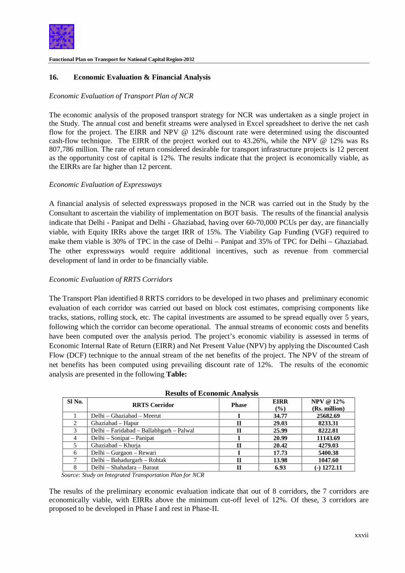
Economic Evaluation of RRTS Corridors The Transport Plan identified 8 RRTS corridors to be developed in two phases and preliminary economic evaluation of each corridor was carried out based on block cost estimates, comprising components like tracks, stations, rolling stock, etc. The capital investments are assumed to be spread equally over 5 years, following which the corridor can become operational. The annual streams of economic costs and benefits have been computed over the analysis period. The project’s economic viability is assessed in terms of Economic Internal Rate of Return (EIRR) and Net Present Value (NPV) by applying the Discounted Cash Flow (DCF) technique to the annual stream of the net benefits of the project. The NPV of the stream of net benefits has been computed using prevailing discount rate of 12%. The results of the economic analysis are presented in the following Table:
Results of Economic Analysis Sl No. RRTS Corridor Phase EIRR
(%) NPV @ 12% (Rs. million)
1 Delhi – Ghaziabad – Meerut I 34.77 25682.69 2 Ghaziabad – Hapur II 29.03 8233.31 3 Delhi – Faridabad – Ballabhgarh – Palwal II 25.99 8222.81 4 Delhi – Sonipat – Panipat I 20.99 11143.69 5 Ghaziabad – Khurja II 20.42 4279.03 6 Delhi – Gurgaon – Rewari I 17.73 5400.38 7 Delhi – Bahadurgarh – Rohtak II 13.98 1047.60 8 Delhi – Shahadara – Baraut II 6.93 (-) 1272.11
Source: Study on Integrated Transportation Plan for NCR
The results of the preliminary economic evaluation indicate that out of 8 corridors, the 7 corridors are economically viable, with EIRRs above the minimum cut-off level of 12%. Of these, 3 corridors are proposed to be developed in Phase I and rest in Phase-II.

Functional Plan on Transport for National Capital Region-2032
xxviii
17. Institutional Arrangement and Financing Institutional Arrangement Institutions are important for successful implementation of policies and programs. They need to be properly structured, adequately empowered and suitably supported with capacity and logistics to effectively discharge their assigned functions. Presently, in NCR, as in other regions of the developing world, the functions and responsibilities of urban transport are dispersed over a number of organizations. There is a need to consolidate, integrate and coordinate. The proposed institutional arrangement should promote:
Seamless movement (including modal transfers) in NCR Dispute free operation Funding of system development Amicable sharing of revenues generated through transport operations Uniform tax structure or at least avoidance of double taxation Uniform fare policy (for services by public transport system)
Consultant studied and analyzed the relevant Acts related to Transport, DDA, NCR, etc. as well as Acts related to Regional Transport Sector in Spain and U.S. After studying the said acts, Consultant has proposed NCR – Transport Planning and Coordination Authority (NCR – TPCA) which shall be responsible for NCR transport policy, planning, integration, funding, coordination and advocacy. Its sphere of action would cover the NCR. The Authority needs to be properly structured in terms of composition, functions, powers, responsibilities and procedures. Consultant has further recommended another single authority, namely “Regional Transport Authority for NCR” (NCR-RTA) under the M.V. Act, 1988 for discharging all relevant functions, within NCR. In addition to the two institutions given above, a number of Special Purpose Vehicles(s) have been suggested by the Consultant in the study report. The aspect of institutional arrangement was discussed in a workshop held on 02.02.2009 with the stakeholders and the suggestions given by the Consultant were not agreed by the NCR constituent States especially the suggestion of Regional Transport Authority for NCR (NCR-RTA) under the M.V. Act, 1988 for the whole region. Therefore, this aspect will require further discussions among the stake holders before deciding about the institutional framework. However, the matter of implementation of Regional Rapid Transit System (RRTS) and its institutional arrangement was discussed and deliberated in the 3rd meeting of the Task Force constituted by the Planning Commission under the Chairmanship of Secretary, Ministry of Urban Development, Government of India held on 09.12.2009 and it was decided that National Capital Region Transport Corporation (NCRTC) would be constituted to implement the RRTS Project in NCR on the lines of Mumbai Rail Vikas Corporation. Representatives of the NCR Constituent States participated in the said meeting. Its objective would be:
i) To develop/strengthen the existing urban / suburban rail infrastructure and other multi-modal
transport services to improve connectivity in NCR. ii) Commercial utilization of land and air space to supplement resources to fund its activities; and iii) To coordinate with Central Government i.e. Ministry of Urban Development; Indian Railways and
NCR Planning Board and Governments of NCT-Delhi, Haryana, Rajasthan and U.P. and other

Functional Plan on Transport for National Capital Region-2032
xxix
related agencies and evolve and execute suitable plans for the development of Sub-urban Rail System of NCR i.e. Regional Rapid Transit System (RRTS).
iv) To operationalise the RRTS and other transport services in coordination with the stake holders.
Funds for implementation of eight sub-urban rails projects included in RRTS and other related works shall be arranged by the NCRTC through its equity holders, market borrowings and other sources. Financing of Transport Plan The Consultant has suggested that a framework needs to be established to tap various financing sources in a cost-effective manner. The design of the framework will take into account issues relating to fiscal constraints, project cash flow profiles, positioning and access to capital markets as well as availability of government funds and grants for this project. We can have appropriate debt equity ratio for the selected projects from the Transport Plan with large component of debt. The equity investment would be distributed among various stake holders. The selection and segmentation would be based on the extent of their interest in the project. The Consultant further suggested in the Study that the debt profile for the Transport Plan project would be dependent on the debt servicing capability of the project cash flows. The debt instruments should be structured with varying risk profiles to meet the requirements of different lenders/Investors. Given the nature of cash flows, the debt services in this project could include India Infrastructure Project Development Fund (IIPDF), Domestic Financial Institutions (DFIs), Jawaharlal Nehru National Urban Renewal Mission (JNNURM), multi-lateral agencies viz JBIC, ADB, World Bank, etc. and other miscellaneous sources e.g. municipal infrastructure bonds, etc. Other sources could be in the form of Tax Exemptions/concessions on account of import/excise duty levied by the Central Government and concessions on stamp duties, sales tax, etc. levied by the State governments. Main source of project revenues would be user charges and for this purpose the average annual volume of commuter traffic and the fare structure as ascertained could be used. It has been suggested in the Study that other possible sources of revenue should be explored to enhance the commercial viability of the project. This could come in the form of advertising revenue, betterment levy, commercial exploitation of land above bus terminals/railway stations, revenue from leasing out refreshment areas & stalls at bus terminals/railway stations, surcharge to be levied on commuters, share of external development charges being collected by development authorities for land development for various purposes, etc. The advertising revenue can come through billboards at terminals and along the alignments, printing at the back of tickets etc.
The financing of various Transport Plan projects will vary from project to project and further elaboration of financing pattern and financing of the projects will be done while preparing the Feasibility Report and Detailed Project Report after carrying out detailed appropriate service. Institutional arrangement for implementation of such projects will also be decided at the same time.
*****