Trail Condition Monitoring - Boulder, Colorado overall goal of trail condition monitoring is to...
17
City of Boulder Open Space and Mountain Parks Visitor Master Plan Management November 6, 2008 Trail Condition Monitoring 1. Background Boulder’s Open Space and Mountain Parks (OSMP) manages over 140 miles of designated trails. OSMP lands receive an estimated 5.3 million visits each year (OSMP 2005). Trends indicate that visitation will continue to increase (OSMP 2004). Increasing levels of use could impact the trail system and affect the quality of the visitor experience and the condition of natural resources. One of the Visitor Master Plan’s (VMP) goals is to ensure that the designated trail system provides a high quality visitor experience while protecting and preserving the physical and environmental resources (OSMP 2005:28-31). To achieve this goal, it is essential to provide and maintain a sustainable trail system. The VMP calls for annual designated trail condition monitoring (OSMP 2005:61). The purpose of this monitoring project is to assess the compliance of our trail system with sustainability standards. Trail condition monitoring identifies unsustainable trail segments, documents the location and condition of constructed features and provides management recommendations or prescriptions for trail maintenance and sustainability. Trail monitoring reports will provide managers with information to strategically allocate staffing and materials, and to prioritize trail maintenance projects. Trail monitoring will also describe the condition of trails and trail features, enabling managers to document and communicate the extent and location of regular trail maintenance needs. This information can be used in conversations with the Open Space Board of Trustees, City Council and interested members of the community. A previous version of this protocol was field tested in 2007. Modifications were made in several areas in response to desires of Open Space and Mountain Parks staff, unanticipated field conditions, availability of equipment, and GIS and database requirements. 2. Project Goal and Objectives The overall goal of trail condition monitoring is to ensure trails are in compliance with pre-existing sustainability standards. The specific objectives set for trail sustainability vary according to trail class and designed use, in accordance with the Open Space and Mountain Parks Trail Framework. These standards are maintained by the Recreation S:\OSMP\PLAN\MONITORING\Infrastructure\Trail\Trail Condition Project\Protocol\FINAL Protocol for Designated Trail Monitoring.doc
Transcript of Trail Condition Monitoring - Boulder, Colorado overall goal of trail condition monitoring is to...

City of Boulder Open Space and Mountain Parks Visitor Master Plan Management
November 6, 2008 Trail Condition Monitoring 1. Background
Boulder’s Open Space and Mountain Parks (OSMP) manages over 140 miles of designated trails. OSMP lands receive an estimated 5.3 million visits each year (OSMP 2005). Trends indicate that visitation will continue to increase (OSMP 2004). Increasing levels of use could impact the trail system and affect the quality of the visitor experience and the condition of natural resources.
One of the Visitor Master Plan’s (VMP) goals is to ensure that the designated trail system provides a high quality visitor experience while protecting and preserving the physical and environmental resources (OSMP 2005:28-31). To achieve this goal, it is essential to provide and maintain a sustainable trail system. The VMP calls for annual designated trail condition monitoring (OSMP 2005:61). The purpose of this monitoring project is to assess the compliance of our trail system with sustainability standards. Trail condition monitoring identifies unsustainable trail segments, documents the location and condition of constructed features and provides management recommendations or prescriptions for trail maintenance and sustainability.
Trail monitoring reports will provide managers with information to strategically allocate staffing and materials, and to prioritize trail maintenance projects. Trail monitoring will also describe the condition of trails and trail features, enabling managers to document and communicate the extent and location of regular trail maintenance needs. This information can be used in conversations with the Open Space Board of Trustees, City Council and interested members of the community.
A previous version of this protocol was field tested in 2007. Modifications were made in several areas in response to desires of Open Space and Mountain Parks staff, unanticipated field conditions, availability of equipment, and GIS and database requirements.
2. Project Goal and Objectives
The overall goal of trail condition monitoring is to ensure trails are in compliance with pre-existing sustainability standards.
The specific objectives set for trail sustainability vary according to trail class and designed use, in accordance with the Open Space and Mountain Parks Trail Framework. These standards are maintained by the Recreation
S:\OSMP\PLAN\MONITORING\Infrastructure\Trail\Trail Condition Project\Protocol\FINAL Protocol for Designated Trail Monitoring.doc

Resource Program Coordinator. A copy of the current standards is included as appendix. For the Marshall Mesa / Southern Grasslands Trail Study Area (MM/SG TSA), individual standards were developed which were specific to each trail segment. These individual standards were used to monitor the trail segments in the MM/SG TSA, and varied slightly to the standards (Appendix 1) used to monitor the remaining TSA’s.
3. Monitoring Objectives The monitoring is intended to provide information to make trail maintenance more efficient and effective. In an attempt to address this objective staff considered both “point sampling” and “problem assessment” approaches to trail condition monitoring (sensu Marion 2001). In weighing the costs (time) and benefits (improvements to trail maintenance efficiency and effectiveness), OSMP staff determined that knowing the nature, location and extent of specific trail sustainability issues was of greater value than a set of precise measurements. For this reason, the approach to monitoring trail condition is focused upon 1) locating areas and features out of compliance with design parameters and 2) describing the nature of non compliance. In addition, the project will also provide prescriptions for addressing the sustainability issues observed in the field. In summary, trail monitoring will consist of three components:
1. Document and assess trail conditions to determine if trails are being
maintained to OSMP selected sustainability standards. 2. Inventory the location and condition of constructed trail features (e.g.
waterbars and retaining walls). 3. Prescribe maintenance actions to mitigate selected problems.
3.1. Component 1: Trail Condition Assessment
The first component of trail monitoring is a condition assessment of the trail segments. This assessment will be comprised of measuring and describing a set of trail indicators at selected locations. These indicators provide information about the physical sustainability of the trail, as well as visitor safety and convenience.
3.1.1. Management Objective Maintain trail segments in compliance with sustainability standards based on the appropriate Trail Management Objective (TMO) design parameters. 3.1.2. Sampling Objective Record the location and extent of places where indicators are outside the range of acceptability defined in the TMO design parameters.
Last saved: 11/6/2008 10:32 AM 2

Indicators to measure: (refer to Table 2 for definitions) • Tread width • Maximum sustained trail grade • Maximum sustained tread outslope • Clearing width • Clearing height • Turn radius • Surface material • Presence of erosion/drainage indicator conditions Statistics • The lineal extent of trails out of compliance with TMO design
parameters. • The degree to which the area is out of compliance. • The location and extent of trails displaying erosion indicator conditions.
Definitions: • Design Parameters: The technical specifications for a trail segment’s
construction and maintenance, based on the Designed Use and Trail Class (USFS 2001). Design parameters are derived from the sustainability standards developed included in the OSMP Trail Management Framework (TMF). (Refer to Appendix for the OSMP Trail Design and Management Technical Specification Standards)
• Designed Use: The intended use that controls the desired geometric design of the trail, and determines the design parameters (width, grade, clearance) for the trail (USFS 2001).
• Erosion/Drainage Indicator Conditions are characteristics of erosion and poor drainage. These indicators include without limitation: muddy areas, water flowing on the tread, and gullies or channels on the tread.
• Physical Sustainability: Sustainability of trails is the ability to support current and future uses while requiring minimal maintenance over extended periods of time.
• Sustainability Standards: Technical specifications of a trail needed to be maintained in order to support the type and volume of use a trail receives. Similar to a trail’s design parameters. Refer to appendix for the OSMP Trail Design and Management Technical Specification Standards.
• Trail Class: The prescribed scale of trail development, representing the intended design and management standards of the trail (USFS 2001).
Last saved: 11/6/2008 10:32 AM 3
• Trail Management Objectives: TMOs document the management intention for the trail and provide key reference information for subsequent trail management, design and construction, maintenance, condition assessment and prescriptions, and reporting (USFS 2001).
• Trail Segment: A continuous portion of a trail with a single combined Designed Use and Trail Class. Trails are divided into a segment where either Designed Use or Trail Class changes.
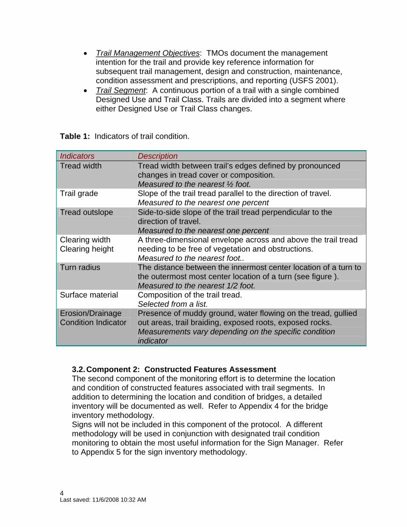
Table 1: Indicators of trail condition. Indicators Description Tread width Tread width between trail’s edges defined by pronounced
changes in tread cover or composition. Measured to the nearest ½ foot.
Trail grade Slope of the trail tread parallel to the direction of travel. Measured to the nearest one percent
Tread outslope Side-to-side slope of the trail tread perpendicular to the direction of travel. Measured to the nearest one percent
Clearing width Clearing height
A three-dimensional envelope across and above the trail tread needing to be free of vegetation and obstructions. Measured to the nearest foot..
Turn radius The distance between the innermost center location of a turn to the outermost most center location of a turn (see figure ). Measured to the nearest 1/2 foot.
Surface material Composition of the trail tread. Selected from a list.
Erosion/Drainage Condition Indicator
Presence of muddy ground, water flowing on the tread, gullied out areas, trail braiding, exposed roots, exposed rocks. Measurements vary depending on the specific condition indicator
3.2. Component 2: Constructed Features Assessment The second component of the monitoring effort is to determine the location and condition of constructed features associated with trail segments. In addition to determining the location and condition of bridges, a detailed inventory will be documented as well. Refer to Appendix 4 for the bridge inventory methodology. Signs will not be included in this component of the protocol. A different methodology will be used in conjunction with designated trail condition monitoring to obtain the most useful information for the Sign Manager. Refer to Appendix 5 for the sign inventory methodology.
Last saved: 11/6/2008 10:32 AM 4
3.2.1. Management Objective Ensure that constructed features are functioning as designed. 3.2.2. Sampling Objective Record the location along trail segments of constructed features and their condition. Indicators to measure: • Effectiveness of constructed features
Varies by feature see reference (date)
Statistic • The location of constructed features (GPS coordinates). • The condition class/code of constructed features (Table 2).
Definitions:
Constructed feature: A human-made structure designed to help maintain a trail’s sustainability, such as to divert water, or retain sediment, or raise the level of the tread (e.g., retaining walls, turnpikes, waterbars, steps, culverts).
3.3. Component 3: Prescriptions for Maintenance
The third component of trail condition monitoring is the development of field prescriptions for non-compliant/maintenance issue areas (areas of concern) and constructed features.
3.3.1. Management Objectives Describe the maintenance actions recommended to bring the trail or feature into compliance with sustainability standards or the feature into effective condition. Prescribe maintenance actions needed for areas of concern to become sustainable based on their TMO. Prescribe maintenance actions to make constructed features effective. 3.3.2. Sampling Objective No sampling for this component of the project. Definitions:
Areas of concern: An area of a trail where design, construction, or patterns of use have created conditions requiring regular maintenance or a safety hazard for users; and where specific activities could mitigate that maintenance need.
Last saved: 11/6/2008 10:32 AM 5

4. Location of Monitoring
Phase I: Methodology Evaluation Monitoring will be conducted on designated trails located within Trail Study Areas (TSAs) (beginning with the Marshall Mesa/Southern Grasslands TSA and Eldorado Mountain/Doudy Draw TSA—both now part of the South TSA).
Phase II DeploymentFollowing evaluation and adjustment as necessary, the methodology will be used in the remaining TSAs
5. Methods
5.1. Preparation
5.1.1. Trail Management Objectives (TMOs) Before field work begins, monitoring staff will ensure that completed and approved Trail Management Objective (TMO) forms are available for each designated trail segment in the project area. TMO information will be entered into the Trails Database1. The relevant specifications for trail segments can be exported from the database. 5.1.2. Map of Trail Segments Before field work begins, monitoring staff will create a map of the trail segments to be surveyed. A map file document with relevant labeling and useful context (background imagery, topography, etc) has been created and is located at: E:\MapFiles\Trails\trail_segments.mxd. 5.1.3. Download Data Dictionary Download the data dictionary for Designated Trail Monitoring into the Trimble Geo-III GPS receiver. The data dictionary is located at: E:\GPS\Data_Dictionaries\Designated_Trails.ddf. 5.1.4. Training Staff will be trained in survey methodology and field equipment use.
5.2. General Data Collection In general, only conditions that extend along the trail for a distance greater than 30’ linear feet will be recorded. Exceptions will be made where the observer considers the severity of the situation to be extreme because of impacts to trail aesthetics, visitor safety, or resource condition. For every non-compliant / maintenance issue and constructed feature encountered along a trail segment, a unique identifier (PortionID) will be assigned in sequential order and recorded in the GPS receiver.
1 E:\Database\trails.mdb
Last saved: 11/6/2008 10:32 AM 6
Component 1: Trail Condition Assessment The following methodology will be used to assess trail condition: • Become familiar with the trail segment’s design parameters (tread
width, maximum sustained grade, maximum sustained outslope, clearing width and height, turn radius, and surface material).
• Walk the length of the trail segment stopping when one of the indicators is judged to be out of standard for a distance of at least 30 feet.
• Using the Trimble Geo-III GPS receiver, record as a point feature the location where the trail begins to be out of compliance for the indicator, record the indicator and the measurement (see below), and the PortionID.
• Record the location when (if) the indicator returns to the acceptable range/value for the indicator as well as the indicator name and measurement.
The following methods will be used to measure indicators:
• Tread Width: Use a tape measure to obtain the length (feet – nearest ½ foot) between the trail’s edges. Refer to Appendix 2 for the definition of trail edge.
o Braided Trails: Use the above procedure for tread width to measure the width (feet – nearest ½ foot) of each braided trail. Record the beginning and end point locations with the Trimble Geo-III GPS receiver.
• Maximum Sustained Trail Grade: Measure the maximum sustained
grade for sections of trail out of standard. Use a digital level to record the grade of a trail. Set a digital level to take readings in percent. Place a digital level on the tread, parallel to the direction of travel, at 3 different locations along the trail to be measured. Record the average of the 3 readings as the maximum sustained grade. A clinometer should be used when constructed features, such as steps, have been installed.
• Maximum Sustained Outslope: Measure the maximum sustained
outslope for sections of trail out of standard. Use a digital level (inclinometer) to record the side to side slope of the tread. Place the inclinometer on the trail surface, perpendicular to the direction of travel, at the sampling point. Record the reading to the nearest one percent.
• Corridor Clearing: Use a tape measure to record the distance (feet) of
the vertical and horizontal clearance from any trailside vegetation located at the sample point. Horizontal measurement should be taken from about 2 feet above ground.
Last saved: 11/6/2008 10:32 AM 7

• Turn Radius: Use a tape measure to record the distance from the center point located on the inside edge of a turn to the center point along the outer edge of a turn. Record the measurement to the nearest foot.
• Surface material: Record the composition of the tread surface from the
following choices (from NTTP undated): ♦ Natural - Native, material used—soil, rock. ♦ Crusher fines - Limestone, granite, or gravel that has been run
through a crusher producing fragments ranging in size from dust to 3/8”. Hardened with soil cements and binders, wetted and compacted, crusher fines create a smooth hard trail surface. Local crusher fine material is often colored light grey .
♦ Gravel - Rock fragments ranging from 1/5 to 3 inches in diameter. Gravel and crusher fines differ from one another in that gravel is screened to remove the fines, which contain the natural binders/cements. Gravels remain loose because they have dead air space within the structures that allow them to drain well and resist compaction.
♦ Road base - A mixture of sand, clay and gravel, with the particular mix varying depending on its use. For trails, this material can be compacted into a fairly hard surface, yet it remains soft enough to be comfortable for horses and trail runners. The material is usually light brown, and has a natural look.
♦ Asphalt - Petroleum-based flexible surface material that provides a smoothly paved surface.
♦ Concrete - A composition of coarse and fine aggregates, Portland cement, and water, blended to give a hard, unyielding, nearly white pavement, which can be finished to any degree of smoothness.
• Erosion/Drainage Indicators: In addition to logging the start and end point for the maintenance issue area, write a brief description of the situation, including: width, depth, # of braids, nature, quantity, size, etc., and the source of the problem.
Record the appearance with a digital photo of all maintenance issue areas. Download and label digital photos with the corresponding PortionID.
Component 2: Constructed Features AssessmentTo determine the location and condition of constructed features, use the following methodology: • Using the Trimble GEO-III GPS receiver, estimate the mid-point of a
constructed feature and take a location reading there.
Last saved: 11/6/2008 10:32 AM 8
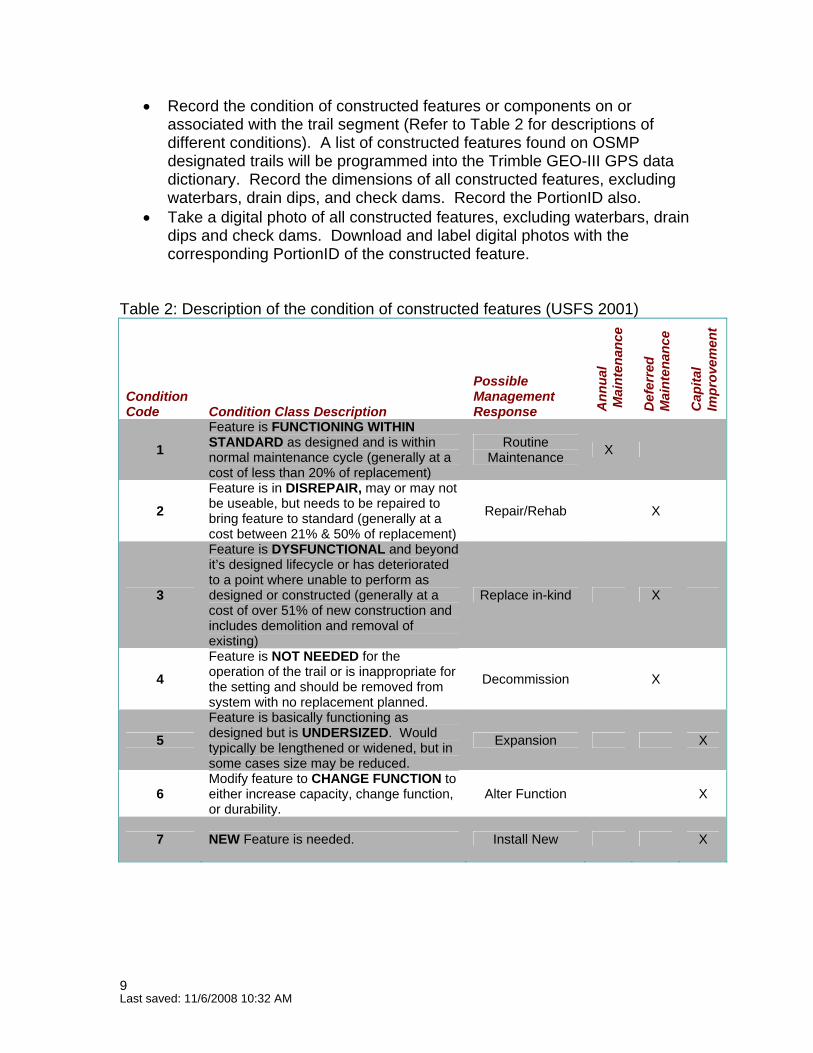
• Record the condition of constructed features or components on or associated with the trail segment (Refer to Table 2 for descriptions of different conditions). A list of constructed features found on OSMP designated trails will be programmed into the Trimble GEO-III GPS data dictionary. Record the dimensions of all constructed features, excluding waterbars, drain dips, and check dams. Record the PortionID also.
• Take a digital photo of all constructed features, excluding waterbars, drain dips and check dams. Download and label digital photos with the corresponding PortionID of the constructed feature.
Table 2: Description of the condition of constructed features (USFS 2001)
Condition Code Condition Class Description
Possible Management Response A
nnua
l M
aint
enan
ce
Def
erre
d
Mai
nten
ance
Cap
ital
Impr
ovem
ent
1 Feature is FUNCTIONING WITHIN STANDARD as designed and is within normal maintenance cycle (generally at a cost of less than 20% of replacement)
Routine Maintenance X
2 Feature is in DISREPAIR, may or may not be useable, but needs to be repaired to bring feature to standard (generally at a cost between 21% & 50% of replacement)
Repair/Rehab X
3
Feature is DYSFUNCTIONAL and beyond it’s designed lifecycle or has deteriorated to a point where unable to perform as designed or constructed (generally at a cost of over 51% of new construction and includes demolition and removal of existing)
Replace in-kind X
4 Feature is NOT NEEDED for the operation of the trail or is inappropriate for the setting and should be removed from system with no replacement planned.
Decommission X
5 Feature is basically functioning as designed but is UNDERSIZED. Would typically be lengthened or widened, but in some cases size may be reduced.
Expansion X
6 Modify feature to CHANGE FUNCTION to either increase capacity, change function, or durability.
Alter Function X
7 NEW Feature is needed. Install New X
Last saved: 11/6/2008 10:32 AM 9

Component 3: Maintenance Prescriptions To prescribe maintenance actions for selected non-compliant / maintenance issue areas and constructed features, use the following methodology: • Use a Maintenance Prescription Form (see appendix 3) to identify and
document maintenance actions needed to bring the trail or feature to standard based on the TMO for the trail segment.
5.3. Data Documentation Data collected for components 1 and 2 will be recorded in a data dictionary programmed into the Trimble GEO-III GPS units. Data collected for component 3 will be recorded on a Trail Maintenance Prescription Form. The following describes data entry on this form: Header Information Trail Name: Record the trail name on which the monitoring occurred.
Trail No: Record the trail number on which the monitoring occurred. Segment No: Record the trail segment number on which the monitoring occurred. Survey Date: Record the date on which the monitoring occurred. Surveyor: Record the name of the person conducting the monitoring. Portion ID: Record the unique id of the area or feature from the GPS receiver which will identify its location. Maintenance Prescription: Describe the maintenance actions recommended to bring the trail or feature into compliance with sustainability standards or the feature into effective condition. 5.4. Sampling periods (Frequency and Timing) In 2007, trail monitoring will take place upon approval of the protocol and during the growing season. The exact timing of sampling will be dependent upon the availability and convenience of staff as there are no diurnal or seasonal conditions likely to significantly affect data collection. The frequency of trail condition monitoring has not yet been determined.
Last saved: 11/6/2008 10:32 AM 10

6. Quality Assurance procedures To ensure that designated trail condition assessments are reliable, accurate and of high quality, it is essential for monitoring staff to be properly trained and experienced. Staff conducting OSMP trail condition assessments must: • Fully understand the Trail Management Objectives for a given trail. • Be able to identify in detail whether the trail meets standards and/or what
it would take to meet standards. • Develop a reasonable prescription for the trail. For the reasons stated above, the US Forest Service (2001) recommends that personnel conducting trail condition assessments have certain qualifications. At a minimum, individuals must have a working knowledge of trail maintenance techniques and trail maintenance and/or construction experience. Certain subjective judgments are required during assessments, and previous trail management experience is essential to ensure as much consistency and accuracy as possible. They must also be proficient in using trail measuring tools such as the compass, wheel and clinometer. Individuals must also have the ability to work independently with a high level of quality.
Training for this protocol should include training with field equipment, practice assessments in the field with OSMP staff, an understanding of the data dictionary, field forms, and post-processing data cleanup (GPS and GIS technical and analytical functions).
6.1. Quality Assurance procedures
It is essential monitoring staff conducting trail condition assessments be trained in GPS technology. Before field work begins, a data dictionary will be created for use with the Trimble GEO-III GPS units. The GPS unit presents its position in UTMs (meters); the map will also have a UTM meters grid for navigation (these are the only metric units to be used in this project). If there is poor GPS coverage:
1. Wait a couple minutes to receive satellite coverage. 2. Adjust sensitivity of GPS (pdop) to record a less-accurate point. 3. Manually record the data. 4. If manually recorded, edit the point later.
7. Data Reduction and Analysis The Trails Database will record and store designated trail condition monitoring data. This includes: • non-compliant/maintenance issue areas (areas of concern) and indicator
measurement data • inventory and condition of constructed features • work prescriptions of recommended maintenance needs
Last saved: 11/6/2008 10:32 AM 11

Data will be summarized through statistical analysis to characterize trail and resource conditions (see Marion 2001). Linear referencing in ArcGIS will be used to obtain the linear distance from the beginning of each trail segment to the beginning and ending of non compliant /unsustainable areas and constructed features. Data from linear referencing will be used to determine percentages of trail and/or segments out of compliance with sustainability standards.
8. Literature Cited: Marion, J.L. and Y. Leung. 2001. Trail resource impacts and an examination of alternative assessment techniques. Journal of Park and Recreation Administration. 19(3):17-37 National Center on Accessibility (NCA) Undated. Surface Evaluation/Monitoring Documentation Procedure. Assessed 6/18/2007. Available online: http://ncaonline.org/trails/research/procedures/surface_evaluation.htmlNational Trails Training Partnership (NTTP) - Glossary of Terms. 2001. Part Three - Trails, Greenway, and Outdoor Recreation Terms. Accessed 6/19/2007. Available online: http://www.americantrails.org/resources/info/glossary3.html#r City of Boulder Open Space and Mountain Parks (OSMP). 2005 Visitor Master Plan. Accessed. 6/19/2007. Available online: http://www.bouldercolorado.gov/index.php?option=com_content&task=view&id=3067&Itemid=1128 United States Forest Service (USFS). 2001. Makin’ TRACS, Forest Service Guide to Trail Assessment and Condition Surveys. Accessed 6/19/2007. Available online: http://www.fs.fed.us/r3/measures/Inventory/TRACS.htm
Last saved: 11/6/2008 10:32 AM 12

Width Height Natural Gravel Crusher Roadbase Concrete Asphalt0-50% >=3' 8.33% <2% 8' 8' 4' ok No ok ok ok ok
Hiking 0-30% 3-5' 8% <=5% 6' 8' 2' ok ok ok ok ok ok
Biking 0-30% 3-8' 8% <=5% 10' 10' 6' No ok ok ok ok ok
Equestrian 0-30% 3-8' 8% <=5% 10' 10' 8' No ok ok ok No No
Official Vehicle N/A 8-10' 8% <= 8% 28-40' 12' 10-12' No ok ok ok ok ok
Hiking 0-50% 2.5-5' 10% <=5% 6' 8' 2' ok ok ok ok No No
Biking 0-50% 3-8' 8% <=5% 6-10' 10' 6' ok ok ok ok No No
Equestrian 0-50% 3-8' 8% <=5% 6-10' 10' 8' ok ok ok ok No No
Official Vehicle N/A 8-10' 6% <= 6% 28' 12' 10-12' No ok ok ok ok ok
Hiking 0-75% 1.5-3' 15% <= 8% 4-6' 8' 2' ok ok ok ok No No
Biking 0-75% 1.5-5' 12% <=5% 4-6' 10' 6' ok ok ok ok No No
Equestrian 0-75% 1.5-6' 12% <=5% 6' 10' 8' ok ok ok ok No No
Official Vehicle N/A 8-10' 6% <=5% 12' 10' 10-12' ok ok ok ok No No
Hiking 0-75% 1.5-2.5' 15% <=10% 4' 8' 2' ok No No No No No
Biking 0-75% 1.5-3' 12% <= 8% 4-6' 10' 6' ok No No No No No
Equestrian 0-75% 1.5-2.5' 12% <= 8% 6' 10' 8' ok No No No No No
Official Vehicle N/A 8-10' 5% <=5% 10' 10' 10-12' ok N/A No No No No
Hiking 0-90% 1.5-2' 15% <=10% N/A N/A 2' ok No No No No No
Biking 0-90% 1.5-2' N/A N/A N/A N/A N/A N/A N/A No No N/A N/A
Equestrian 0-90% 1.5-2' N/A N/A N/A N/A N/A N/A N/A No No N/A N/A
Official Vehicle N/A 8-10' 4% <= 3% N/A N/A 10-12' ok N/A No No No No
Climbing N/A 0-2' N/A <=15% N/A N/A N/A ok No No No No No
Class 5 Fully
Developed
Class 4 Highly
Developed
Class 3 Developed/ Improved
Class 2 Minor
Development
Class 1 Primitive/
Undeveloped
Trail Design Parameters provide guidance for the assessment, survey and design, construction, repair and maintenance of trails, based on the Trail Class and Designed Use of the trail.
Exceptions and variances to these parameters can occur when site-specific circumstances demand such exceptions. These exceptions should be noted in the TMO for the trail.
* Accessible is currently a separate Trail Class. If assessing/designing trails for accessibility, refer to current Agency trail accessibility guidance.
X-Slope Range
Tread Width
Finalized 12/04/07
Trail Design & Management Guidelines MatrixClearing
Accessible
Max. Sustained
Grade
Max. Sustained Outslope
Surface MaterialsTurn Radius
Climbing Access
S:\OSMP\PLAN\MONITORING\Infrastructure\Trail\Trail Condition Project\Protocol\FINAL Protocol for Designated Trail Monitoring.doc
Appendix 1: (Revised) Trail / Road Design & Management Standards Comparison

Clear definition of the edge of the trail is essential towards accurate trail measurements. Marion (2002) defines the edge as follows:
S:\OSMP\PLProtocol for Desig
AN\MONITORING\Infrastructure\Trail\Trail Condition Project\Protocol\FINAL nated Trail Monitoring.doc
Appendix 2: Definition of Trail Edge
“[The edge is] the most pronounced outer boundary of visually obvious human disturbance created by trail use (not trail maintenance like vegetation clearing). These boundaries are defined as pronounced trampling-related changes in ground vegetation height (trampled vs. untrampled), cover, composition, or, when vegetation cover is reduced or absent, changes in organic litter (intact vs. pulverized). The objective is to define the trail tread that receives the majority (>95%) of traffic, selecting the most visually obvious outer boundary that can be most consistently identified by you and future trail surveyors. Include secondary treads …only when they are not differentiated from the main tread by strips of less disturbed (taller) vegetation or organic litter”.

Segment No:Trail Name Trail No:
Survey Date Surveyor
Description of Problem Area Maintenance PrescriptionPortion ID
:\OSMP\PLAN\MONITORING\Infrastructure\Trail\Trail Condition Project\Protocol\FINAL Protocol for Designated Trail Monitoring.doc
Appendix 3: Trail and Feature Maintenance Prescription Form
S

S:\OSMP\PLProtocol for Desig
AN\MONITORING\Infrastructure\Trail\Trail Condition Project\Protocol\FINAL nated Trail Monitoring.doc
Appendix 6: Methodology for Bridge Inventory
Bridge Inventory Methodology The bridge inventory will record the location, condition, and characteristics of certain features of bridges found along Designated Trails. Staff from the Trails Department identified certain characteristics of bridges to record for inventory. These are listed below and are also contained in the Designated Trail Monitoring data dictionary located at: E:\GPS\Data_Dictionaries\Designated_Trails.ddf Preparation Gain an understanding of the following terms associated with bridges:
• Span length - The distance between two immediate supports. • Decking - The surface people/vehicles walk/ride on. • Stringers - Provides support for the decking, parallel to bridge. • Abutment material - Platform/earthen embankment supporting central
bridge structure (stringers). • Bumpers - Low lying runners along decking edge.
Field Data Collection When a bridge is encountered on a trail, stand in the middle and record its location as a point feature using the Trimble Geo-III GPS receiver. Use the ‘bridges’ section in the data dictionary to do this. Pause the logging of additional points, then scroll through the rest of the ‘bridges’ inventory section to measure and record the following information:
• Trail segment number • Span length • Decking length, width, height and material • Stringer length, width and material • Abutment material • Railings present • Bumpers present • Constructed by • Constructed when
Data Processing Transfer the GPS data files into GPS Pathfinder. Export into ArcGIS as shapefiles. Export the attribute tables into the Trails Database Bridge Inventory.

Appendix 5: Methodology for Sign Inventory Sign Inventory Methodology The sign inventory will record the location and basic condition of specific trail sign types located at a trailhead or anywhere along a trail. The Sign Manager (Meg Daniel) identified 12 different types of signs to document. These sign types are listed below in the Field Data Collection section, and are also contained in the Designated Trail Monitoring data dictionary located at: E:\GPS\Data_Dictionaries\Designated_Trails.ddf Preparation Gain an understanding of the different types of signs and how to identify them. Contact the Sign Manager to obtain pictures of different sign types or to arrange a sign identification field trip on a local trail. Field Data Collection When one of the specific sign types is located at a trailhead or along the trail, stand next to the sign and record the location as a point feature using the Trimble Geo-III GPS receiver. Scroll through the data dictionary to record the following information while standing next to the sign:
• Sign Types: (choose one) 1. 6x6 2. Boundary Structure 3. Dog Station 4. Double Wide 5. HCA-DW 6. Interpretive 7. Little Buddy 8. Parking or Trailhead 9. Reg or EE Board 10. Reveg Post 11. Social Trail Post 12. Spec Dog Regs 6x6
• Trail Segment: Record the trail segment number. • RegBoard Plot Name: The name is located at the top of the RegBoard. • At trailhead? Yes/No • Trail Name: Record the name of the trail where the sign is located. • TSA: Record the TSA the sign is located within. • Need Repair? Yes/No.
Data Processing Transfer the GPS data files into GPS Pathfinder. Export into GIS as shapefiles. Inform the Sign Manager where the files are stored.
Last saved: 11/6/2008 10:32 AM 17