Toward More Transparent Government Workshop on eGovernment and the Web 1 Exploring eGov Cooperation...
21
1 Toward More Transparent Government Workshop on eGovernment and the Web Exploring eGov Cooperation and Knowledge Sharing using Geospatial Ontologies in a Semantic Wiki Gary Berg-Cross, Ph.D. Engineering Management & Integration (EM&I) Suite 350 455 Spring park Place Herndon VA 20170 703-742-0585 [email protected] EGov web/knowledge portals are among the most complex webs in existence, based on the size (368 million pages in US .government domain in 2005), number of users, number of information providers and the diversity of information.
-
date post
18-Dec-2015 -
Category
Documents
-
view
214 -
download
0
Transcript of Toward More Transparent Government Workshop on eGovernment and the Web 1 Exploring eGov Cooperation...
1Toward More Transparent Government
Workshop on eGovernment and the Web
Exploring eGov Cooperation and Knowledge Sharing using Geospatial
Ontologies in a Semantic Wiki
Gary Berg-Cross, Ph.D.Engineering Management & Integration (EM&I)
Suite 350 455 Spring park PlaceHerndon VA 20170
EGov web/knowledge portals are among the most complex webs in existence, based on the size (368 million pages in US .government domain in 2005), number of users, number of information providers and the diversity of information.
2
Toward More Transparent GovernmentWorkshop on eGovernment and the Web
Topics
1. Background –eGov foundations and the web/knowledge management challenge - Geospatial Line of Business example
2. Incremental semantics requires better semantic analysis1. Semantic Wiki and Communities of practice play a role
3. Focused work of the Spatial Ontology Community of Practice (SOCoP) 1. Is a CoPs a natural starting point to help with such work?
2. The SOCoP wiki
4. Summing up
3
Toward More Transparent GovernmentWorkshop on eGovernment and the Web
eGov Work in Context
• eGov Act of 2002 established an Intergovernmental Committee on Government Information (ICGI) and Data Integration Pilots, Federal Enterprise Architecture work such as:– Data Reference Model (DRM) and its Data Management Strategy to
enable Intergovernmental Data Exchange. – Supported by conferences whose material is stored on Wikis:
• SICoP Special Conference: Building DRM 3.0 and Web 3.0 by Managing Context Across Multiple Documents and Organizations .
• http://colab.cim3.net/cgi-bin/wiki.pl?SICoP
• We have growing web content on eGov but it doesn’t necessarily cohere or grow in expected ways.
• The job of gaining a unified view of an enterprise’s knowledge assets across government remains difficult to implement in practice and current Wiki approaches (including above) seem too ad hoc to provide progressive integration.

4
Toward More Transparent GovernmentWorkshop on eGovernment and the Web
Challenging eGov example: The Geospatial LOB
Geospatial LoB Vision
Su
pp
ort
Su
pp
ort
Su
pp
ort
GOALS
OPTIMIZED AND STANDARDIZED COMMON GEOSPATIAL FUNCTIONS, SERVICES, AND PROCESSES THAT ARE
RESPONSIVE TO CUSTOMERS
PRODUCTIVE INTERGOVERNMENTAL COLLABORATION FOR GEOSPATIAL-RELATED ACTIVITIES AND
INVESTMENTS ACROSS ALL SECTORS AND LEVELS OF GOVERNMENT
COST EFFICIENT ACQUISITION, PROCESSING, AND ACCESS TO GEOSPATIAL DATA AND INFORMATION
THE NATION’S INTERESTS ARE SERVED, AND THE CORE MISSIONS OF FEDERAL AGENCIES AND THEIR PARTNERS ARE MET, THROUGH THE EFFECTIVE AND EFFICIENT DEVELOPMENT, PROVISION, AND INTEROPERABILITY OF GEOSPATIAL DATA AND SERVICES.
OBJECTIVES
§ TO IMPROVE GOVERNANCE PROCESSES AND RESULTS IN ALIGNMENT WITH COMMON GEOSPATIAL SOLUTIONS
§ TO IDENTIFY, EVALUATE AND IMPLEMENT COMMON GEOSPATIAL SERVICES, PROCESSES AND BEST PRACTICES
§ TO ENHANCE COORDINATION ACROSS GEOSPATIAL COMMUNITY STAKEHOLDERS
OBJECTIVES
§ TO IMPLEMENT GUIDANCE PROVIDED THROUGH THE FEA GEOSPATIAL PROFILE
§ TO ADOPT, DEPLOY AND PROMOTE EFFECTIVE USE OF GEOSPATIAL INTEROPERABILITY STANDARDS
§ TO ESTABLISH AN LOB-WIDE BUSINESS ARCHITECTURE FOR COMMON FUNCTIONS ASSOCIATED WITH GEOSPATIAL INFORMATION
OBJECTIVES
§ TO COORDINATE GEOSPATIAL REQUIREMENTS AND CAPABILITIES
§ TO IDENTIFY OPPORTUNITIES AND CONSOLIDATE GEOSPATIAL ACQUISITION ACTIVITIES
§ TO ENHANCE LOB-WIDE PORTFOLIO MANAGEMENT § TO DEVELOP AND IMPLEMENT GEOSPATIAL REQUIREMENTS
LANGUAGE FOR FEDERAL GRANTS AND CONTRACTS
ISSUES
INEFFECTIVE PERFORMANCE ACCOUNTABILITY UNDERDEVELOPED COST AVOIDANCE STRATEGY INEFFECTIVE MULTI-MISSION SERVICE DELIVERY CAPABILITY AND COMPLIANCE MECHANISMS
Su
pp
ort
Su
pp
ort
Su
pp
ort
COMMON SOLUTION TRACKS
ENHANCED GOVERNANCE PLANNING & INVESTMENT STRATEGY OPTIMIZE & STANDARDIZE DATA & SERVICES
IMPLEMENT PERFORMANCE ACCOUNTABILITY DEVELOP COORDINATED BUDGET PLANNING, ACQUISITION SHARED AND REUSABLE GEOSPATIAL AND COMPLIANCE MECHANISMS AND LABOR COST AVOIDANCE GEO-ENABLED BUSINESS DATA AND SERVICES
5
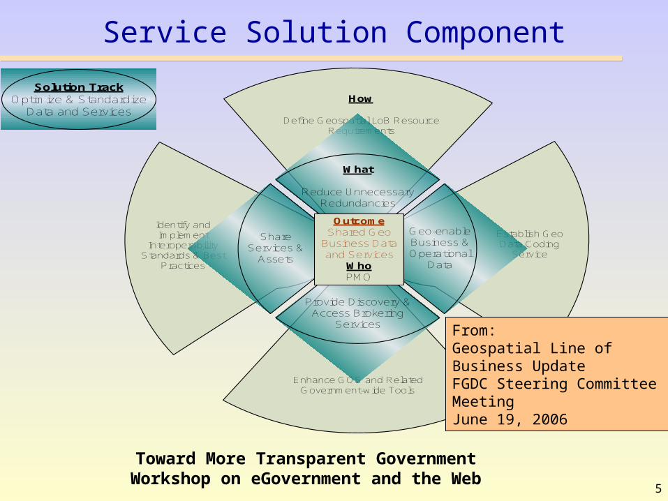
Toward More Transparent GovernmentWorkshop on eGovernment and the Web
Service Solution Component
Identify and Implement
Interoperability Standards & Best
Practices
Enhance GOS and Related Government-wide Tools
How
Define Geospatial LoB Resource Requirements
ShareServices &
Assets
What
Reduce Unnecessary Redundancies
Establish Geo Data Coding
Service
Geo-enable Business & Operational
Data
Provide Discovery & Access Brokering
Services
OutcomeShared Geo
Business Data and Services
WhoPMO
Solution TrackOptimize & Standardize
Data and Services
From: Geospatial Line of Business Update FGDC Steering Committee MeetingJune 19, 2006

6
Toward More Transparent GovernmentWorkshop on eGovernment and the Web
Foundations for eGov - Architecture and Supporting Collaboration with Wikis
EnterpriseArchitectures
Service OrientedArchitectures
Wikis as repositories of information about EA, SOA etc.
Interagency Collaborative Expedition Workshops, community groups as typified by ONTOLOG & COLAB, SICoP, DRM site etc.
7
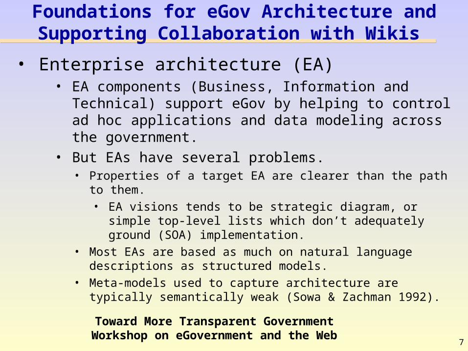
Toward More Transparent GovernmentWorkshop on eGovernment and the Web
Foundations for eGov Architecture and Supporting Collaboration with Wikis
• Enterprise architecture (EA) • EA components (Business, Information and
Technical) support eGov by helping to control ad hoc applications and data modeling across the government.
• But EAs have several problems. • Properties of a target EA are clearer than the path to them.
• EA visions tends to be strategic diagram, or simple top-level lists which don’t adequately ground (SOA) implementation.
• Most EAs are based as much on natural language descriptions as structured models.
• Meta-models used to capture architecture are typically semantically weak (Sowa & Zachman 1992).

8
Toward More Transparent GovernmentWorkshop on eGovernment and the Web
Heaping Geospatial Entity Types Together in an EA
Very general entity of Location Object has the same sub-type relation to the parent “geospatial entity” as Observation
Observation is a relational concept – an “event through which a number, term or other symbol (i.e. measurement) is assigned to a phenomenon at a location at a given point in time.”
From DHS EA, 2006
It would be nice to start on a geospatial vocabulary model, even as informal as FOAF, but the community has to reach some agreements on the basic vocabulary used across many standards.
9
Toward More Transparent GovernmentWorkshop on eGovernment and the Web
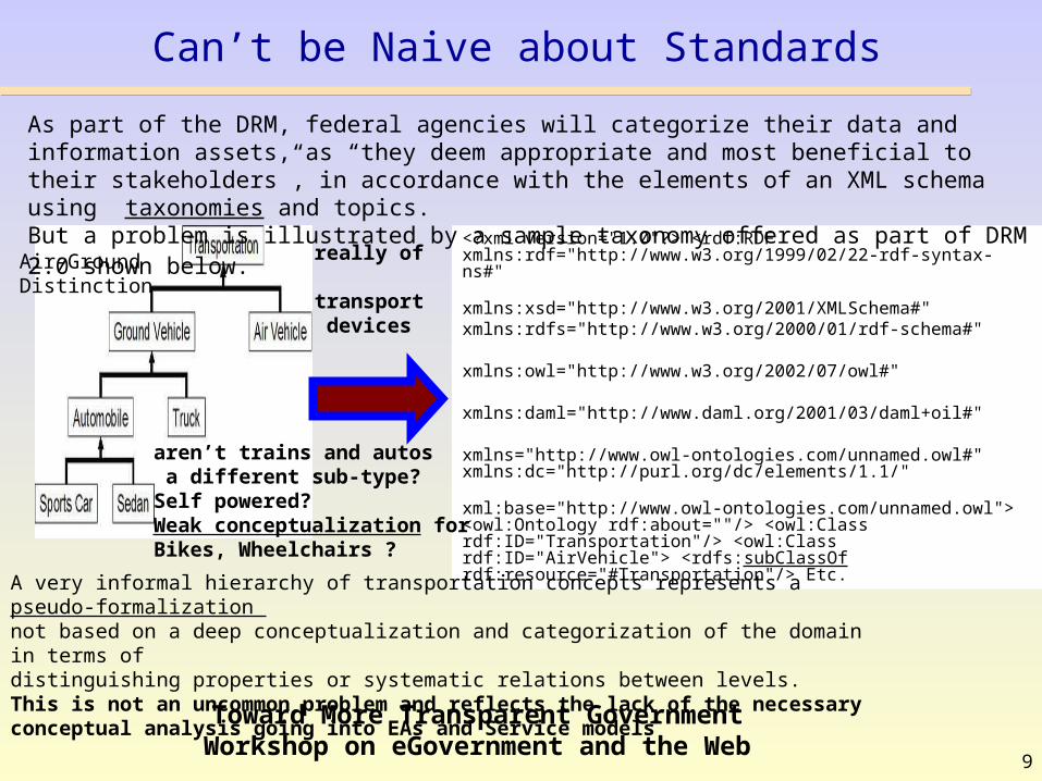
Can’t be Naive about Standards
<?xml version="1.0"?> <rdf:RDF xmlns:rdf="http://www.w3.org/1999/02/22-rdf-syntax-ns#"
xmlns:xsd="http://www.w3.org/2001/XMLSchema#" xmlns:rdfs="http://www.w3.org/2000/01/rdf-schema#"
xmlns:owl="http://www.w3.org/2002/07/owl#"
xmlns:daml="http://www.daml.org/2001/03/daml+oil#"
xmlns="http://www.owl-ontologies.com/unnamed.owl#" xmlns:dc="http://purl.org/dc/elements/1.1/"
xml:base="http://www.owl-ontologies.com/unnamed.owl"> <owl:Ontology rdf:about=""/> <owl:Class rdf:ID="Transportation"/> <owl:Class rdf:ID="AirVehicle"> <rdfs:subClassOf rdf:resource="#Transportation"/> Etc.
As part of the DRM, federal agencies will categorize their data and information assets, as “they deem appropriate and most beneficial to their stakeholders”, in accordance with the elements of an XML schema using taxonomies and topics.But a problem is illustrated by a sample taxonomy offered as part of DRM 2.0 shown below.
A very informal hierarchy of transportation concepts represents a pseudo-formalization not based on a deep conceptualization and categorization of the domain in terms of distinguishing properties or systematic relations between levels. This is not an uncommon problem and reflects the lack of the necessary conceptual analysis going into EAs and Service models
aren’t trains and autos a different sub-type?Self powered?Weak conceptualization for Bikes, Wheelchairs ?
really of transport devices
Air-GroundDistinction

10
Toward More Transparent GovernmentWorkshop on eGovernment and the Web
Semantic Web Tech & Challenges
• Creating a richer (Semantic) Web infrastructure to practically organize the content and relations of the EGov webs would have several payoffs– but it is challenging. Not just size but structure. Some
challenges:– A wiki is not pre-determined, and neither top
down or bottom up so how do we: • Structure it consistently?• Handle its evolution driven by the user
community?• Keep the markup for “authors” “very simple”?
– How do we move from current Wikis to more semantic ones?

11
Toward More Transparent GovernmentWorkshop on eGovernment and the Web
Maybe a Cop Helps Solve Some of This
Community of Practice• Small group of people who've worked together over a period of
time (or formed to do that). • Somewhat informal - not a team, not a task force, not
necessarily an authorized or identified group. – peers in the execution of "real work"
• What holds a CoP together is a common sense of purpose, exposure to a common class of problems, common pursuit of solutions, thereby themselves embodying a store of knowledge with a real need to know what each other knows or at least thinks they know. – But there are many sub-communities…and formal vs informal
approaches• A COP can use a Wiki to coordinate actions, describe
progress and the knowledge gathered reused in other efforts (like FEA effort), especially if we share a common metadata schema for the efforts.
12
Toward More Transparent GovernmentWorkshop on eGovernment and the Web
Spatial Ontology Community of Practice (SOCoP) officially begun in October of 2006
• Purpose SOCoP chartered as a CoP under the Best Practices Committee of the Federal CIO Council
• Role– Foster collaboration among researchers, technologists & users of spatial knowledge
representations and reasoning towards the development of spatial ontologies for use by all in the Semantic Web.
– Support open collaboration and open standards for increased interoperability of spatial data across government
– Synchronize with Geospatial Profile of FEA and the Geospatial LOB as well as across the entire spectrum of applicable geospatial standards (via W3C, ISO, OGC, etc.).
Goal to establish a more coordinated approach to producing, maintaining, and using geospatial data and services and ----ensure sustainable participation from Federal partners to establish a collaborative model for geospatial-related activities and investments.
– Document best practices, and create opportunities to partner with other cross domain and ontology CoP groups.
– Help inventory geospatial ontologies, develop an approach to institutionalizing and streamline the effort to support the development and management of ontologies across geospatial lines of business both in and out of government
13
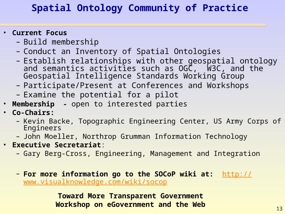
Toward More Transparent GovernmentWorkshop on eGovernment and the Web
Spatial Ontology Community of Practice
• Current Focus– Build membership– Conduct an Inventory of Spatial Ontologies– Establish relationships with other geospatial ontology and semantics
activities such as OGC, W3C, and the Geospatial Intelligence Standards Working Group
– Participate/Present at Conferences and Workshops– Examine the potential for a pilot
• Membership - open to interested parties• Co-Chairs:
– Kevin Backe, Topographic Engineering Center, US Army Corps of Engineers– John Moeller, Northrop Grumman Information Technology
• Executive Secretariat:– Gary Berg-Cross, Engineering, Management and Integration
– For more information go to the SOCoP wiki at: http://www.visualknowledge.com/wiki/socop
14
Toward More Transparent GovernmentWorkshop on eGovernment and the Web
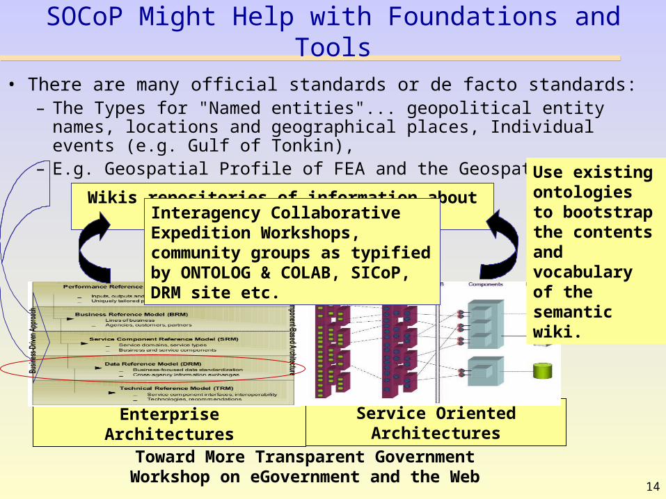
SOCoP Might Help with Foundations and Tools
• There are many official standards or de facto standards: – The Types for "Named entities"... geopolitical entity names, locations and
geographical places, Individual events (e.g. Gulf of Tonkin), – E.g. Geospatial Profile of FEA and the Geospatial LOB
EnterpriseArchitectures
Service OrientedArchitectures
Wikis repositories of information about EA, SOA etc.Interagency Collaborative
Expedition Workshops, community groups as typified by ONTOLOG & COLAB, SICoP, DRM site etc.
Use existing ontologies to bootstrap the contents and vocabulary of the semantic wiki.
15
Toward More Transparent GovernmentWorkshop on eGovernment and the Web
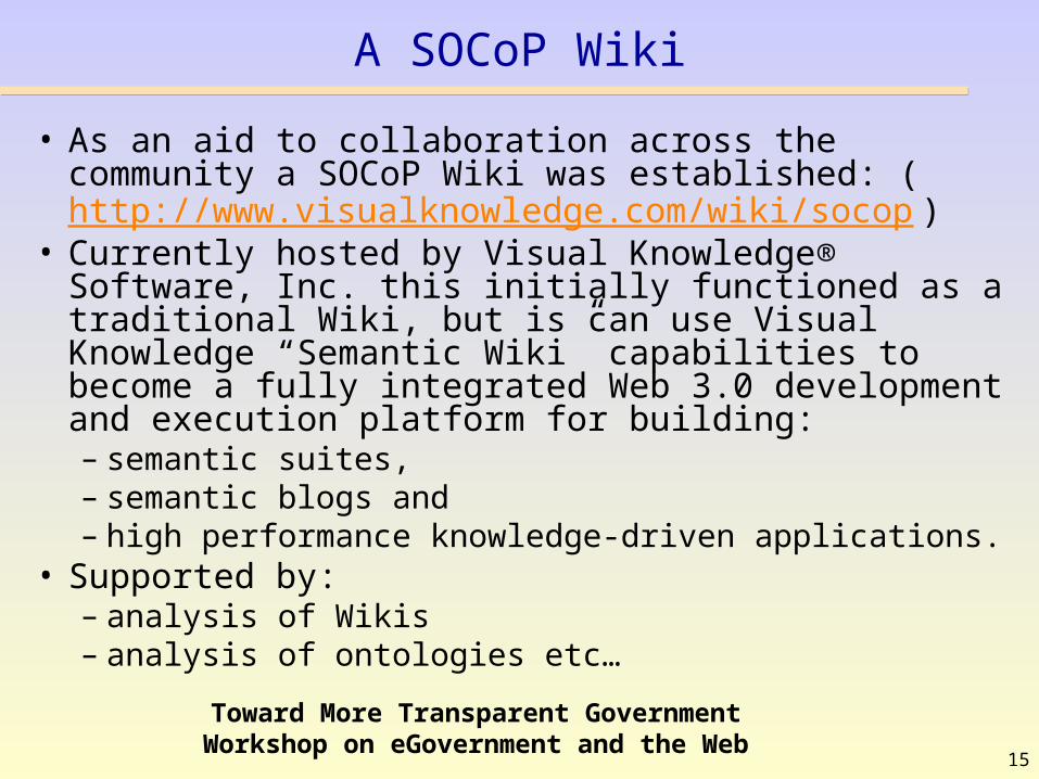
A SOCoP Wiki
• As an aid to collaboration across the community a SOCoP Wiki was established: (http://www.visualknowledge.com/wiki/socop)
• Currently hosted by Visual Knowledge® Software, Inc. this initially functioned as a traditional Wiki, but is can use Visual Knowledge “Semantic Wiki” capabilities to become a fully integrated Web 3.0 development and execution platform for building:– semantic suites, – semantic blogs and – high performance knowledge-driven applications.
• Supported by:– analysis of Wikis– analysis of ontologies etc…

16
Toward More Transparent GovernmentWorkshop on eGovernment and the Web
The Big, Messy Picture
SOCoP
EAsSOAs
EAsEAs
EAs
SOAsSOAs
SOAsSOAs
supports
Migrates/Leverages/Links to
usesPart of
analyzesGeospatialOntologies/K
Geospatial Profile
Part of
analyzes
eGov ( linked)
Wikis/Portals
….Documents……
Wikis/Portals
….
Wikis/Portals
….
Wikis/Portals
….
Geospatial Standards
SemanticWikis
SOCoPWiki
Our work would be to add:
Here is how these geospatial standards are expressed as an Ontology andHere are the relevant datasets (vector, raster etc.) from each gov agency (UGS, NGA, NASA, FEMA, DHS, …)Here is how ontologies (maybe a sample for each agency) can be used to improved the geospatial profile and Here is how the FGDC geographic framework (defines different layers of info e.g. cadastral, elevation, hydrography, transportation etc.) can be improved to serve as a core andHere is how ontologies can be represented on a Wiki and, here is how to annotate a page on geospatial topics and….

17
Toward More Transparent GovernmentWorkshop on eGovernment and the Web
The SOCoP Wiki
Transparent eGovWorkhop Near
Here
18
Toward More Transparent GovernmentWorkshop on eGovernment and the Web
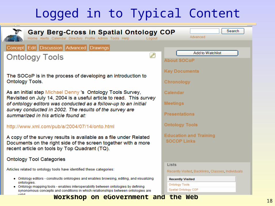
Logged in to Typical Content
19
Toward More Transparent GovernmentWorkshop on eGovernment and the Web
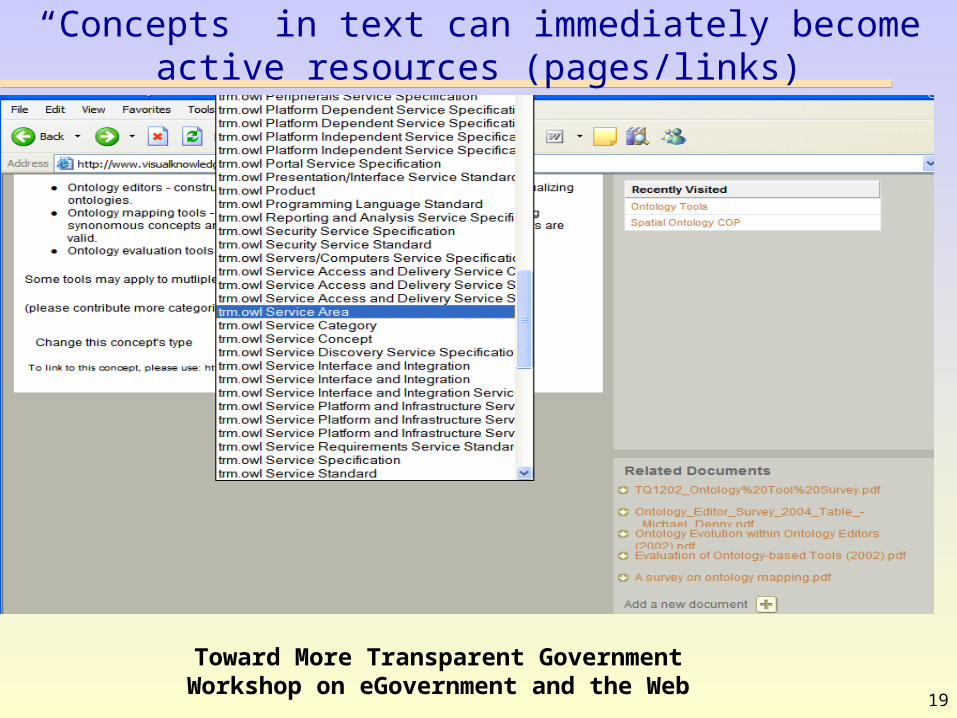
“Concepts” in text can immediately become active resources (pages/links)
20
Toward More Transparent GovernmentWorkshop on eGovernment and the Web
Additional Wiki Capabilities
Considering how we would like to use the wiki we want to:• Easily reference existing geospatial ontological
vocabularies/standards from the wiki,• import data from existing, external (RDF/OWL)
ontologies, – allow these to be stored, edited and approved by the
community in the wiki.• Utilize geospatial schema information and constraints
from external models ando ntologies,• Support matching and comparison of SOCoP
developed ontologies with others (external)All to aid things like the Geospatial Profile, DRM etc.

21
Toward More Transparent GovernmentWorkshop on eGovernment and the Web
Summary of Ontological COP as a Semantic Wiki Testbed
1. SOCoP community discussion is intended as a iterative, since a living ontology relies chiefly on its community.
2. Strategically a community devoted to building ontologies may be a great position to build semantic wikis if for no other reason than that its users are already familiar with ontological concepts and their development.
3. SOCoP is particularly suited as a semantic wiki testbed because the geospatial domain is widely relevant but has a theoretical core of concepts well developed and focused.
4. For all of these reasons SOCoP represents a practical testbed for semantic Wikis. It is also useful for demonstrating ontology design that is:
• Meaningful - all named classes can have instances• Formal –can be represented/put into a form amenable to automated processing• Rigorous – stands up to rational analysis (geospatial entity example)• Correct - captured intuitions of domain experts• Minimally redundant - no unintended synonyms• Sufficiently axiomatized – include detailed constraining descriptions as axioms


![eGov-Aug-2010-[7]-eGov Innovations](https://static.fdocuments.in/doc/165x107/568c49e51a28ab491695febc/egov-aug-2010-7-egov-innovations.jpg)