
Units 1 + 2 The Succession Crisis John and Edward S3 History class revision.
Upload
rob-henshawCategory
view
212download
0description
International Cities Town Centres & Communities Society
ICTC2011 Grand Chancellor Hotel, Hobart, Australia
25 – 28 October, 2011
Participatory Urban Design in Kiribati:
A Community Driven Solution
John Tocker B. Arch (Auckland), ANZIA, ICTC, Registered Architect (NZ) Director / Jerram Tocker Barron Architects Ltd / New Zealand
Phone: +64 4 4739803 Fax: +64 4 4739805 Email: [email protected] Web: www.jtbarchitects.co.nz
ABSTRACT
Kiribati comprises 33 islands spread an exclusive economic zone of 3.6 million km2 of the central Pacific. The land area is only 816km2, and the population is approximately 100,000. South Tarawa, the capital of Kiribati, has a population of nearly 50,000 on a string of islets 19km long & averaging 250m wide. The highest point is 3.6m above mean sea level, the population density is extremely high and is the fastest growing urban population in the Pacific. This paper examines the “Sustainable Towns Programme” for South Tarawa, Kiribati, through a case study that outlines the challenges facing the expanding population significantly affected by climate change and consequent sea level rise. Consultation between local residents, government stakeholders and independent experts indicated an “enquiry by design” approach allowing for direct input from all key stakeholders.
Inclusive, “enquiry by design” charettes were undertaken involving local residents as well as Government officials and technical experts. There was a real need to understand climate change and culturally specific requirements, as well as accepted Urban Design tenets.
Lessons learnt are the benefits of an inclusive approach, how graphic techniques in charettes break down cultural and language barriers, the need to understand local settlement patterns, and the necessity to avoid solely skills based approaches when dealing across geographical and cultural boundaries. KEYWORDS: Urban Planning, Pacific, Climate Change, Public Participation, Sustainable Development.

Participatory Urban Design in Kiribati: A Community Driven Solution INTRODUCTION The New Zealand Aid Program is mandated to “support sustainable development in
developing countries in order to reduce poverty and to contribute to a more secure,
equitable, and prosperous world”. 1 The Kiribati Urban Development Programme
(KUDP) is a long-term (10-15 years) joint NZAID - Government of Kiribati (GoK)
initiative aimed at improving the capacity of Kiribati’s urban areas to adapt to, and
address, the development challenges arising from increasing levels of urbanisation,
leading to an improved quality of life for urban dwellers.
This project was to produce an Urban Plan for a 150 site demonstration village on
a salt marsh on the island of South Tarawa. It formed part of the Planning
component of the Urban Development Programme which provided for “Sites and
Services” (new residential plots and ancillary land uses on serviced land) to cater for
existing and future growth of low and low-middle income households on a phase by
phase basis. Within this component a General Land Use Plan (GLUP) and a
Detailed Land Use Plan (DLUP) required development.
The overall development objective/goal is to provide for the orderly development of
serviced residential plots for low to middle-low income households and associated
land uses. The area targeted was recommended by the Preliminary Environmental
Impact Assessment (SMEC Consultants, Feb 2010).
For more than 40 years there have been questions regarding the efficacy of foreign
aid, its tendency to be heavy on resources, of high cost, and producing poor
outcomes (Graber 1966). Further, Townsend & Tully (2004) cite self-selection of
contributors, inconsistent access to the process, errors in analysis of consultation,
and differing levels of input according to social class, as barriers to effective
participation in Urban Planning.
This demonstration project needed to respond to overcrowding and poorly serviced
sites elsewhere on South Tarawa. It also needed to take account of the different
desired outcomes for the different stakeholders: e.g.: NZ Government, Kiribati
Government, the Local Authority (Tenainano Urban Council (TUC)), local technical
experts, and the residents and end users.
Other parts of the project had already established the legal framework for the
process, whereby the Local Land Planning Board, as an agent of the Local Authority
(TUC), is charged with effecting and administering the Detailed Land Use Plan.
1 www.aid.govt.nz
This allowed direct engagement with the Local Authority, and through the Deputy
Mayor, a local resident himself, access to the local community and residents.
According to Arnstein (2006), effective contribution arises at the level of participation,
not consultation or information. Therefore a participatory approach was predicated
for the work. Without this participation, the project risked ignoring key local issues,
lacking insight into the realities of a different culture, and missing nuances obvious to
local residents.
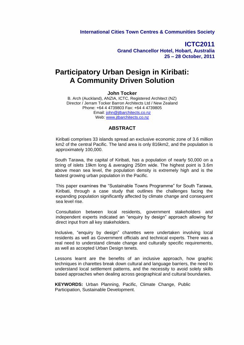
To show equal value to all the participants, while allowing full
participation and direct input to the outcomes, an “Enquiry by
Design” 2 approach was used. This charette model is widely
known and used within western communities, notably by the
Prince’s Foundation3. The assumption behind the Enquiry by
Design model was that a graphic process would minimise
cultural and language barriers. The use of translators for the
local residents’ workshops, so that they were conducted in the
Kiribati language, also contributed to ease a situation where
new development risked drawing criticism from local residents.
METHODOLOGY
The approved plans, GLUP & DLUP, were produced
over the course of three visits to Tarawa commencing
with the consultation visit in February 2010. The
information gathering part of the work included
individual interviews and briefings with key
stakeholders, followed by participatory workshops in
“Enquiry by Design” charettes.
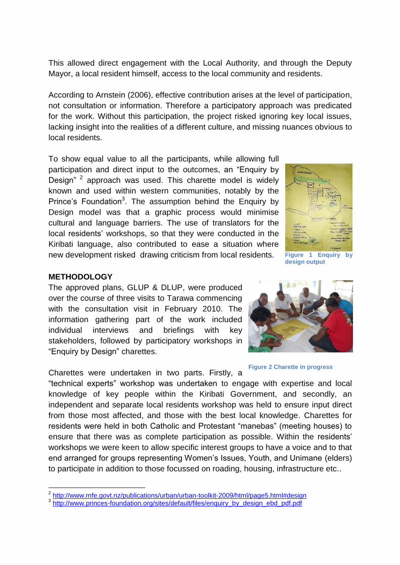
Charettes were undertaken in two parts. Firstly, a
“technical experts” workshop was undertaken to engage with expertise and local
knowledge of key people within the Kiribati Government, and secondly, an
independent and separate local residents workshop was held to ensure input direct
from those most affected, and those with the best local knowledge. Charettes for
residents were held in both Catholic and Protestant “manebas” (meeting houses) to
ensure that there was as complete participation as possible. Within the residents’
workshops we were keen to allow specific interest groups to have a voice and to that
end arranged for groups representing Women’s Issues, Youth, and Unimane (elders)
to participate in addition to those focussed on roading, housing, infrastructure etc..
2 http://www.mfe.govt.nz/publications/urban/urban-toolkit-2009/html/page5.html#design
3 http://www.princes-foundation.org/sites/default/files/enquiry_by_design_ebd_pdf.pdf
Figure 2 Charette in progress
Figure 1 Enquiry by design output

Draft General & Detailed Land Use Plans were prepared reflecting the content of the
workshops. These were reviewed during a second round of charettes on the second
visit in May 2010 prior to being updated as final drafts for public consultation. The
mandatory three month public consultation period occurred July-Sept 2010 and a
final visit occurred in Nov 2010. At this time there was an interactive presentation to
local Members of Parliament and the Local land Planning Board, followed by a last
local residents workshop before finalising both Plans for Local and Central Land
Planning Board approval, Environmental approval from the Ministry of Environment,
Land, and Agriculture, and ratification by the Kiribati Government Cabinet.
EXTERNAL PARTICIPATION IN URBAN PLANNING
Water quality (both fresh and salt) is a huge issue for South Tarawa. Although based
on anecdotal evidence, it is understood that over 25% of the population reports
annually to medical clinics suffering from gastric problems directly related to poor
water quality. The project was informed by:
An initial Environmental Assessment by Paul Schutz et al (SMEC) showed the
area for development was highly saline, and subject to partial inundation. It
included a partial survey, showing that the subject land was extremely low lying,
ranging from 150 to 300mm above mean high water spring tides.
A separate, but related workshop hosted by the Asian Development Bank,
focused on Water & Sanitation and highlighted that a multiple work stream
approach was required as sanitation and water issues are inextricably linked to
land ownership and management.
Additional presentations by Dr Arthur Webb (SOPAC) & Doug Ramsay (NIWA)
provided expert information regarding the impact of climate change on atoll and
lagoon environments. The lagoon at South Tarawa now flushes poorly, due to
multiple causeways. Dr Webb showed multiple measures of Coliform counts
along the South Tarawa lagoon exceeding 4500/100ml whereas beaches are
closed in NZ at rates of 280/100ml.
PLANNING CONSIDERATIONS RESULTING FROM PARTICIPANT DESIGN
The General Land Use Plans and Detailed Land Use Plans are regulatory
requirements under Kiribati legislation. The DLUP logically forms a detailed plan
subordinate to the GLUP. Both the GLUP & the DLUP were generated
simultaneously removing conflict between these two parts of the planning process.
Land Level: With land levels being particularly low, there is significant risk of
inundation. This is mitigated somewhat by the causeway to the west, and two wave
built ridges to the east. However, the current use of the land as a coconut plantation
has failed due to the high water table and its salinity, and the danger of future sea
level rise makes it imperative that land levels are raised. The exact rise is a matter
for professional engineers rather than Urban Planners, but locally the ridge along
which the houses are built (an old peninsula into the lagoon) is approx. 700-900mm
above the surrounding area, and a new school site has been raised a similar
amount. The project has always included for a raised platform across the entire site.
Bonriki Water Reserve: The reserve shown on the GLUP is a vital part of the future
of South Tarawa as it is the primary lens of potable water and the source for
reticulated supply for the rest of South Tarawa.
Airport: The airport is a vital connection to outer islands and the outside world. It is
one of the key employers at the eastern end of South Tarawa. The airport as a key
driver of future economic growth. Additional airport zoning is allowed in the GLUP.
Bonriki Village: The main part of Bonriki Village is centred to the south of the
runway west of the airport terminal buildings. Other parts are north-west of the
runway, and a lower density area of housing is distributed along the southern side of
the runway east of the terminal buildings. These areas largely conform with the
original coastline prior to the construction of the Ananau causeway and the
consequent reclamation of the Temwaiku Bight. The GLUP leaves these areas as
existing.
Temwaiku : Temwaiku Village curls around the coast east of the Ananau Causeway.
The area is less densely populated than it close neighbour Bikeneibeu, and lacks a
school, significant shops or places of major employment. It includes key local
amenities such as the Catholic Maneaba and the Kiribati Protestant Church, both of
which provide hubs for parts of the local community.
Lagoon: To the west of the Ananau causeway the lagoon forms the edge of the
GLUP area. This is one of the areas where there is the longest flushing period in the
Tarawa lagoon, in one small part reaching up to 50 days in modelling presented by
Dr Arthur Webb (SOPAC). It remains a significant food source for local residents,
and thus the protection of the ecology is critical. There has already been a small
amount of mangrove planting along the west side of the causeway, and an extension
of this planting as a Reserve is included in the GLUP to assist in providing both a
filter for run off from the land and a nursery area for sea life.
Community Facilities: There are very few existing community facilities in the area.
The main facilities are the Outer Island Maneabas at Temwaiku and the churches at
Temwaiku and Bonriki. Local Residents see the new development as an opportunity
for the area to achieve some Community Amenities not currently available. The
DLUP therefore includes land allocation by zoning for such uses.
Commercial Development: There is an opportunity with the GLUP to designate
land for Commercial activity. Sound Urban Planning principles indicate that the best
location will likely be where there is a logical “node” of increased activity and traffic,
both pedestrian and vehicular. There is also a need to provide communities with
identity, and one way of ensuring a village centre and distinct identity is to group
commercial activities towards the centre. The GLUP has included land zoned
specifically for Commercial development.
Village Concept: From inception the project aimed to show how future development
can be structured to support improved health outcomes, better community outcomes,
and an urban form that stands the test of time. This meant that while the project
needed to be identifiably different from its neighbouring residential areas, it was also
critical that there was a willingness and an acceptance for the works from the
neighbours of Tamoa Village who would be sharing resources, amenities and space
with the new village. During the charettes a curious request arose for a “buffer zone”
between the existing and new communities. This seemed strange given that
elsewhere locally i-Kiribati people choose to live close together. After further
discussion and enquiry, and some drawings by one of the Unimane (Elders), it
became apparent that traditional land holding in South Tarawa runs across the
island, from lagoon side to ocean side in narrow strips marked by boundary stones. It
also became apparent that the western concept of land rights did not stop at the
water’s edge, but extended some distance out from the shore. Examples were cited
where land owners elsewhere had reclaimed “their” foreshore out into the lagoon to
provide additional space for piggeries and housing. With the local State Land on
which the new village is to be built only arising after the Ananau Causeway was built
across Temwaiku Bight in 1971, local people still regarded the site as old seabed,
and therefore they held property rights out at least as far as could have been
reasonably available for reclamation. As a result of this discovery, a “buffer zone” of
20m was agreed between existing residents and the new village, and the local
people were instantly in favour of a project they had previously not actively
supported.
Roading Pattern: During the technical workshop there was a detailed discussion
regarding roading patterns. The group did not favour cul-de-sacs due to their
inherent lack of connectivity, and there was a perceived benefit in having “sub-
communities” with distinct groups of plots. After lengthy discussion the pattern that
appealed to the participants was a tree & branch pattern where the roading hierarchy
is obvious, and the link to a naturally occurring pattern had a clear reference point
that all could understand. The technical workshop called this Te Mai – the breadfruit
tree, which is a key food source on the island, and also has connotations of
nurturing. The proposed DLUP layout is based on this pattern, with looped low speed
narrow vehicle routes, and pocket parks either side of the main road. This layout
ensures good connectivity between adjacent streets and allows pedestrian traffic to
pass through the ends of the loops to the coconut plantation to the north, or to the
existing Tamoa community to the south. This pattern also supports neighbourhood
blocks that can operate as a “sub-community”.
Plot Sizing: The charettes showed houses that contained piggeries, vegetable
gardens, and multiple open sided elevated rooms (kiakia & buia). Technical advice
indicated that fire was a risk as there is no water sufficient for fire fighting. Soil on
South Tarawa is relatively saline coral sand. It is naturally low in nutrients, and aid in
understanding the management of organic matter and compost to build up soils
quality is a key element to increasing food production. The Taiwanese Technical
Mission operates a horticultural and animal husbandry aid project in the Temwaiku
area, and continues to advance this work. Together, these drivers of open sleeping
rooms, fire separation, and garden space show a requirement for reasonable
separation between buildings. Setbacks of 2m to side and rear boundaries were
included, and with vehicles needing off road space, and local roads not likely to be
paved, the existing 5m setback from roads was retained. With a 2m setback either
side and a reasonable minimum width road frontage of 10m there is still a 6m width
for the buildings. With a 25m deep lot the effective building area is 6m* 18m =
108m2: a reasonable minimum for a household of 6 or more people. This is
particularly true if a traditional model of housing is used, where sleeping, living,
cooking and ablution areas are largely in separate buildings. The minimum plot size
is therefore 250m2 with a minimum street frontage of 10m.
Community & Commercial Areas: Household size in Kiribati is large, averaging
over 10 persons/household. Allowing for a reduced household size in future in line
with world trends, the new village can still be expected to have a final population of
over 1000 people. In combination with the surrounding area this will mean over 6000
in the Temwaiku / Bonriki GLUP area. There are currently no community facilities
other than churches and a few kiosk style shops in the area. There is little
employment available other than subsistence fishing/agriculture and work associated
with the airport. The DLUP has therefore provided for Commercial and Community
Facilities areas as requested by both the Residents and the Technical charettes.
Wet Blocks: As a result of the initial investigations on Kiribati, there was concern
that providing serviced sites for lessees on low / middle incomes, could merely
relocate existing slums from overcrowded areas of Bairiki & Betio. Thus the brief was
revised to include “wet blocks”. The wet block is a minimum services facility
containing shower, hand basin and WC plus an external sink bench. These functions
necessitate water storage tank and sewage. This approach avoids any expectation
of a hand-out and allows low / middle income households to achieve their own home
with a lower capital input, requiring a lower entry point for lessees. Residents most in
need from overcrowded areas elsewhere on South Tarawa will be able to afford the
long term lease, and can stage the completion of their house over time as funding
permits.
Infrastructure: In order to meet minimum health standards the plots require water
and sanitation connections, and electric power at least to the boundary. The main
roads are envisaged as sealed, while minor roads are coral surfaced consistent with
other island infrastructure. Water supplies are insufficient at present, and the water
mains are not in good condition. The combination of insufficient supply and the poor
condition of the network has led to intermittent provision to those with a reticulated
service, and consequent ingress of polluted ground water during times where the
water pressure is not maintained. The difficulty with the salinity of even clean ground
water means that rain water harvesting to tanks is included. Sanitation is proposed
as a Combined Effluent Disposal (CED) system with septic tanks on site and outfalls
from each septic tank being combined into a common deep outfall beyond the reef.
CONCLUSIONS
This project has proven the value of local participation in the Urban Planning
process. Despite the cultural differences, the charettes, with graphic input from small
groups and feedback to a wider audience of their peers has provided a vital insight

into local issues, planning constraints, and cultural requirements. Without this high
level of participation the project would have failed to gain support from local
residents, local authorities or central government. Instead, the GLUP & DLUP Urban
Plans have gained a high level of support. In particular the work achieved:
Real “buy-in” from local residents, and multiple requests to lease land in
the new village prior to any work starting on site
Active support from the local Mayor and Deputy Mayor
Active support from local Members of Parliament
Unanimous acceptance from the Local Land Planning Board
Unanimous acceptance from the Central Land Planning Board
Support from the Ministry of Environment Lands and Agriculture
Support from the Kiribati Cabinet
Support from the NZ Minister of Foreign Affairs
These key stakeholders were convinced that the work had merit and deserved
support. The Kiribati Urban Development Program has consciously focussed its
efforts at Local Authority empowerment in the expectation that this is where local,
low level, long term strategic decisions will have the greatest sustainability. This
expectation is predicated on an inclusionary process that values and facilitates local
ideas rather than imposing ideas from outside. The “Enquiry by Design” methodology
has been especially useful in crossing cultural boundaries and enabling local
knowledge and ideas to be incorporated and carried through the project.
It was critical to create a high trust environment from the outset by including local
stakeholders from the outset. In this way every stage of the work could be seen to
include the work of the local people, to respond positively to their superior knowledge
of local climate, settlement patterns, and the nuances of topography and weather not
obvious to a Urban Planner from outside the society.
The work has provided confidence to the local people in uncertain times, and its
sustainability is due to their participation and ability to build on the work in the future.
ACKNOWLEDGEMENTS
The author wishes to acknowledge the assistance of the Government of Kiribati,
Ministry of Environment, Lands & Agriculture; the Secretary; Ms Tarsu Murdoch, and
the Deputy Secretary, Ms. Teboranga Tioti, Lands Division staff; Mr. Tebutonga
Ereata Ms Reei Tioti, and Mr. Harry Redfern. Invaluable access to local residents
was gained through Mayor Mr. Tokia Craig, and Vice Mayor Mr. Tierimo
Ueanimatang. Special thanks for organisation on South Tarawa to Ms. Sina Moy-
Taberannang.
Thanks also to colleagues on the Kiribati Urban Development Project; Dr. Colleen
Butcher-Gollach, Jon Metcalf, Wallace Rogers, and Lourdes Jiminez; NZ AID Project
Sponsor, Ms Sonya Cameron, NZ High Commissioner to Kiribati, Mr. Ropati Kawai.
REFERENCES 1. Arnstein, Sherry R. "A Ladder of Citizen Participation," JAIP, Vol. 35, No. 4, July
1969,pp.216-224 (file:///H:/ICTC/References/A%20Ladder%20of%20Citizen%20Participation%20-%20Sherry%20R%20Arnstein.htm)
2. Graber Doris A. “Are Foreign Aid Objectives Attainable?” The Western Political Quarterly Vol. 19, No. 1 (Mar., 1966), pp. 68-84 (http://www.jstor.org/stable/445472)
3. Townsend A. & Tully J. “Modernising Planning: Public Participation in the UK Planning System” paper presented to European Regional Science Association (ERSA) Porto, Portugal, August 25-29, 2004 (http://econpapers.repec.org/paper/wiwwiwrsa/ersa04p51.htm)
4. Amado M., Santos C., Moura E., & Silva V. “Public Participation in Sustainable Planning” World Academy of Science Engineering & Technology 53 2009 (http://www.waset.org/journals/waset/v53/v53-97.pdf)
5. Professor John Hockings et al “Temaiku Project - Tarawa Urban Futures Project”, Queensland University of Technology. 19 November 2004.
(http://en.scientificcommons.org/41720563)
6. Government of Kiribati, Land Management Division, MELAD. “Summary of Findings and Recommendations from the Land Planning Act Review.” March 2008.
7. White I.. “Tarawa Water Master Plan for: Future Water Demand.” December 2010 Kiribati Adaptation Programme Phase II Water Component 3.2.1 World Bank, AusAID, and NZAID.
(http://www.climate.gov.ki/pdf/KAPII/KAPII%20-%20Water%20Master%20Plan%20Demand%20-%20Government%20of%20Kiribati.pdf)
8. Shutz P. et al. “Republic of Kiribati – Sustainable Programme Site Investigation Assessment.” January 2010
9. Tocker J. “Final Planning Support Report; Kiribati Urban Development Program; State Land at Temwaiku, South Tarawa, Kiribati”. NZ AID, January 2011


![Package 2 Renovate All Three Buildings · JOHN 048 jerram tocker ARCHITECTS 0001 llt.m.ei]l . Created Date: 2/5/2019 1:02:14 PM ...](https://static.fdocuments.in/doc/165x107/601b26dc939bc507032de232/package-2-renovate-all-three-john-048-jerram-tocker-architects-0001-lltmeil-.jpg)


![Package 3 Expand Hall Footprint - ARO VALLEY COMMUNITY …...JOHN 048 jerram tocker ARCHITECTS 0001 llt.m.ei]l . Created Date: 2/5/2019 1:02:14 PM ...](https://static.fdocuments.in/doc/165x107/601b26dc939bc507032de22f/package-3-expand-hall-footprint-aro-valley-community-john-048-jerram-tocker.jpg)


