to at its 10/17/95 C55 W 25235
96
MINUTE ITEM This Calendar Item No.C55 was approved as Minute Item No. _35 by the State Lands CALENDAR ITEM C55 Commission by a vote of _3 to_ at its 10/17/95 .Buyeew A 11 10/17/95 S 7 W 25235 PRC 7859 N. Smith ISSUANCE OF A GENERAL LEASE- RIGHT OF WAY. USE APPLICANT: . . Chevron U.S.A., Inc. 5080 California Avenue, Suite 400 Bakersfield, California 93309-1671 AREA, TYPE LAND AND LOCATION: A parcel of tide and submerged across Pacheco Slough near the City of Martinez, Contra Costa County. LAND USE: Modification and reactivation of an existing 8" pipeline to transport refined petroleum products. LEASE TERMS: Lease period: Twenty-five years beginning September 20, 1995. Surety bond: $50,000. Public liability insurance: Combined single limit coverage of $1,000,000. Consideration: $100 per annum; with the State reserving the right to fix a different rental on each fifth anniversary of the Lease. BASIS FOR CONSIDERATION: Pursuant to 2 Cal. Code Regs. 2003. APPLICANT STATUS: Applicant is permittee of upland. -1. CALENDAR PAGE MINUTE PAGE 2065 221
Transcript of to at its 10/17/95 C55 W 25235

MINUTE ITEM This Calendar Item No.C55
was approved as Minute ItemNo. _35 by the State Lands
CALENDAR ITEM
C55
Commission by a vote of _3 to_ at its 10/17/95.Buyeew
A 11 10/17/95
S 7 W 25235PRC 7859 N. SmithISSUANCE OF A GENERAL LEASE-RIGHT OF WAY. USE
APPLICANT: . . Chevron U.S.A., Inc.
5080 California Avenue, Suite 400 Bakersfield, California 93309-1671
AREA, TYPE LAND AND LOCATION: A parcel of tide and submerged across Pacheco Slough near the City of Martinez, Contra Costa County.
LAND USE: Modification and reactivation of an existing 8" pipeline to transport refined petroleum products.
LEASE TERMS: Lease period:
Twenty-five years beginning September 20, 1995.
Surety bond: $50,000.
Public liability insurance:
Combined single limit coverage of $1,000,000.
Consideration: $100 per annum; with the State reserving the right to fix a different rental on each fifth anniversary of the Lease.
BASIS FOR CONSIDERATION: Pursuant to 2 Cal. Code Regs. 2003.
APPLICANT STATUS: Applicant is permittee of upland.
-1.
CALENDAR PAGE
MINUTE PAGE 2065
221

CALENDAR ITEM NO. C55 (CONT 'D)
PREREQUISITE CONDITIONS, FEES AND EXPENSES: Filing fee, processing costs, and environmental costs have been received.
STATUTORY AND OTHER REFERENCES: A. P.R.C.: Div. 6, Parts 1 and 2; Div. 13.
B. Cal. Code Regs.: Title 3, Div. 3; Title 14, Div. 6.
AB 884: 2/26/95
OTHER PERTINENT INFORMATION: 1 . Chevron proposes to modify and reactivate an existing 8" pipeline that was
constructed in 1970, and repair two other pipelines within this existing pipeline corridor. Since the rights-of-way for the pipelines have not been previously leased to Chevron by the Commission, staff proposes the Commission consider the approval of the reactivation of the 8" pipeline, known as the Tosco-Richmond Products Pipeline, and to allow repair of two other pipelines within the existing corridor in Pacheco Slough with a lease application for the pipelines to be filed by Chevron within six months.
2. Pursuant to the Commission's delegation of authority and the State CEQA Guidelines (14 Cal. Code Regs. 15025), the staff has prepared a Proposed Negative Declaration identified as ND 671, State Clearinghouse No. 95083031. Such Proposed Negative Declaration was prepared and circulated for public review pursuant to the provisions
of CEQA.
Based upon the Initial Study, the Proposed Negative Declaration, and the comments received in response thereto, there is no substantial evidence that the project will have a significant effect on the environment. (14 Cal. Code Regs. 15074(b)) A Mitigation Monitoring Plan has been prepared in conformance with the porvisions of the CEQA. (Public Resources Code Section 21081.6)
3 . This activity involves lands which have NOT been identified as possessing significant environmental values pursuant to P.R.C. 6370, et seq. However, the Commission has declared that all tide and submerged lands are "significant" by nature of their public
ownership (as opposed to "environmentally significant"). Since such declaration of
-2-
CALENDAR PAGE
MINUTE PAGE 2064 222

CALENDAR ITEM NO. C55 (CONT 'D)
significance is not based upon the requirements and criteria of P.R.C. 6370, et seq., use classifications for such lands have not been designated. Therefore, the finding of
the project's consistency with the use classification as required by 2 Cal. Code Regs. 2954 is not applicable.
APPROVALS OBTAINED: U.S. Army Corps of Engineers, Contra Costa County Planning Department, and the San Francisco Bay Regional Water Quality Control Board.
FURTHER APPROVALS REQUIRED: State Lands Commission .
EXHIBITS: A. Location Map B. Site Map C. Negative Declaration D. Monitoring Plan
IT IS RECOMMENDED THAT THE COMMISSION: 1 . CERTIFY THAT A PROPOSED NEGATIVE DECLARATION, ND 671, STATE
CLEARINGHOUSE NO. 95083031, WAS PREPARED FOR THIS PROJECT PURSUANT TO THE PROVISIONS OF THE CEQA AND THAT THE COMMISSION HAS REVIEWED AND CONSIDERED THE INFORMATION CONTAINED THEREIN.
2 ADOPT THE NEGATIVE DECLARATION AND DETERMINE THAT THE PROJECT, AS APPROVED, WILL NOT HAVE A SIGNIFICANT EFFECT ON THE ENVIRONMENT.
3 ADOPT THE MITIGATION MONITORING PLAN, AS CONTAINED IN EXHIBIT "D", ATTACHED HERETO.
4. AUTHORIZE ISSUANCE TO CHEVRON, U.S.A., INC. OF A TWENTY-FIVE-YEAR GENERAL LEASE-RIGHT OF WAY USE BEGINNING SEPTEMBER 20, 1995; IN CONSIDERATION OF ANNUAL RENT IN THE AMOUNT OF $100, WITH THE STATE RESERVING THE RIGHT TO FIX A DIFFERENT RENTAL ON EACH FIFTH ANNIVERSARY OF THE LEASE; PROVISION OF A $50,000 SURETY BOND; PROVISION OF PUBLIC LIABILITY INSURANCE FOR COMBINED SINGLE LIMIT
-3-
CALENDAR PAGE 223
MINUTE PAGE 2067

CALENDAR ITEM NO. C55 (CONT 'D)
COVERAGE OF $1,000,000; FOR REACTIVATION OF AN EXISTING 8" PIPELINE CROSSING PACHECO SLOUGH ON THE LAND DESCRIBED ON EXHIBIT "A" ATTACHED AND BY REFERENCE MADE A PART HEREOF.
5. AUTHORIZE CHEVRON TO REPAIR TWO OTHER PIPELINES WITHIN THIS PIPELINE CORRIDOR ACROSS PACHECO SLOUGH.
-4-
CALENDAR PAGE
MINUTE PAGE 2068
224

MAP
SONOW SUISUN
PETALUMA
NOVATO
VALLEJO NO VISTA
SAN PABLO BAY BENECK
PITTSBUR
SITE
SAN RAFAEL
RICHMOND
BERKELEY
SAUSALITO NVS OAKLAND
This Exhibit, is solely for purpose ofFRANCISCO generally defining the lease premise, andSAN FRANCISCO
is not intended to be, nor shall it be SAN LEANDRO construed as, a waiver or limitation
BRISBANE of any State interest in the subject or any other property.
HAYWARD . BURLINGAME
EXHIBIT "A" SAN MATEO
Location Map
W 25235 General Lease, FREMONT Chevron Pipeline Pacheco Slough
PALO ALTOContra Costa County
SAN JOSE
CALENDAR PAGTROY 22
MINUTE PAGE JKH 08-95 2068)

SOCAND
CONTRA
VINE HILL STATION
EXHIBIT B Site Map
W 25235 General Lease
Chevron Pipeline Pacheco Slough
Contra Costa County
TE
COSTA
AT 6 8 S
-TOSCO REFINERY PF -AVON TERMINAL
SITE PROPOSED TOSCO
PACKCCO PUMP STATION
GRAYSON CHECKPROPOSED PIPELINE
This Exhibit is solely for purpose of generally defining the lease premise, and is not intended to be, nor shall it be construed as, a waiver or limitation of any State interest in the subject or any other property
CALENDAR PAGBKH 09-9126
MINUTE PAGE 2070

PETE WILSON, GovernorSTATE OF CALIFORNIA EXHIBIT
EXECUTIVE OFFICECALIFORNIA STATE 100 Howe Avenue, Suite 100-SouthLANDS COMMISSION Sacramento, CA 95825-8202
GRAY DAVIS, Lieutenant Governor ROBERT C. HIGHT, Executive Officer 916) 574-1800 Fax (916) 574-1810KATHLEEN CONNELL, Controller
California Relay Service from TDD Phone 1-800-735-2922RUSSELL S. GOULD, Director of Finance from Voice Phone 1-800-735-2929
August 15, 1995 File: W 25235 ND 671
SCH # 95083031
NOTICE OF PUBLIC REVIEW
AND INTENT TO ADOPT A PROPOSED NEGATIVE DECLARATION
(SECTION 15073 CCR & SECTION 21092 PRC)
A Negative Declaration has been prepared pursuant to the requirements of the California Environmental Quality Act (Section 21000 et seq., Public Resources Code), the State CEQA Guidelines (Section 15000 et seq., Title 14, California Code Regulations), and State Lands Commission Regulations (Section 2901 et seq., Title 2, California Code Regulations) for a project application currently being processed by the staff of the State Lands Commission.
This document is attached for your review. Comments should be addressed to the State Lands Commission office shown above with attention to the undersigned. All comments must be received by September 15, 1995.
The Negative Declaration will be considered for adoption at a meeting of the State Lands Commission no earlier than September 15, 1995. You will be notified of the date and location at least 10 days prior to the meeting.
Should you have any questions or need additional information, please call the undersigned at (916) 574-1893.
GOODYEAR K. WALKER Division of Environmental
Planning and Management Attachment
CALENDAR PAGE 227
MINUTE PAGE 2071

STATE OF CALIFORNIA PFTF WTLOON. Com
EXECUTIVE OFFIC CALIFORNIA STATE 100 Howe Avenue, Suite 100-Sou LANDS COMMISSION Sacramento, CA 95825-82
ROBERT C. HIGHT, ExecutiGRAY DAVIS, Lieutenant Governor (916) 574-1800 Fax (916) 574-18KATHLEEN CONNELL, Controller
California Relay Service from TDD Pixvic 1-800-735-29RUSSELL S. GOULD, Director of Finance from Voice Phone 1-800-735-25.-
PROPOSED NEGATIVE DECLARATION
File: W25235 ND 671
Project Title: Avon to Vine Hill Pipeline
Proponent: Chevron Pipe Line Company
Project Location: In Contra Costa County, between the Tosco Avon Refinery and Chevron's Vine Hill station.
Project Description: One mile of 10-inch pipeline will be added to an existing 1.3 miles of 8-inch pipeline, and repairs will be performed on two other pipelines within the same 2.3 miles of right-of-way.
Contact Person: Goodyear K. Walker Phone: (916) 574-1893
This document is prepared pursudant to the requirements of the California Environmental Quality Act (Section 21000 et seq., Public Resources Code), the State CEQA Guidelines Section 15000 et seq., Title 14, California Code Regulations); and the State Lands Commission regulations (Section 2901 et seq., Title 2, California Code Regulations).
Based upon the attached Initial Study, it has been found that: . this project will not have a significant effect on the environment.
X mitigation measures included in the project will avoid potentially significant effects.
CALENDAR PAGE 228
MINUTE PAGE 2072

STATE LANDS COMMISSION
ENVIRONMENTAL IMPACT ASSESSMENT CHECKLIST - PART II File Ref.: W25235Form 13.20 (7/82)
I. BACKGROUND INFORMATION
A. Applicant:
Chevron Pipe Line Company
. .5080 California Avenue
Bakersfield. CA 93309
B. Checklist Date: 08 / 15 / 95
C. Contact Person: Goodyear K. Walker
Telephone: (916) 574-1893
D. Purpose:_To repair and perform maintenance on three existing petroleum pipelines_.'
E. Location: In Contra Costa Count from the Tosco Avon Refinery to the Chevron Vine Hill station
F. Description: One mile of 10-inch pipeline will be added to an existing 1.3 miles of &-inch pipeline. and repairs will be perfo
on two other pipelines within the same 2.3 mile right-of-way.
G. Persons Contacted: see attached Initial Study.
229CALENDAR PAGE
MINUTE PAGE 2073

II. ENVIRONMENTAL IMPACTS. (Explain all "yes" and "maybe " answers)
Yes MaybA. Earth. Will the proposal result in:
1. Unstable earth conditions or changes in geologic substructures?. .
. . . . .2. Disruptions, displacements, compaction, or overcovering of the soil?
3. Change in topography or ground surface relief features?.. . . . .. .
4. The destruction, covering, or modification of any unique geologic or physical features? . . . . . . . . . -
5. . Any increase in wind or water erosion of soils, either on or off the site? . . . . . .. .
6. Changes in deposition or erosion of beach sands, or changes in siltation, deposition or erosion which may modify the channel of a river or stream or the bed of the ocean or any bay, inlet, or lake? . . . .
7. Exposure of all people or property to geologic hazards such as earthquakes, landslides, mudslides, ground failure, or similar hazards? . . . . . . . . . . . . . . . . . . . . . . . . . . . . .
B. Air. Will the proposal result in:
1. Substantial air emissions or deterioration of ambient air quality? . . .
2. The creation of objectional odors? .
3. Alteration of air movement, moisture or temperature, or any change in climate either locally or regionally?_
C. Water. Will the proposal result in:
1. Changes in the currents, or the course or direction of water movements, in either marine or fresh waters?
2. Changes in absorption rates, drainage patterns, or the rate and amount of surface water runoff? . . . . . . .
3. Alterations to the course or flow of flood waters? . . . . . . . . .
4. Change in the amount of surface water in any water body? . . . . . . .
5. Discharge into surface waters, or in any alteration of surface water quality, including but not limited to temperature, dissolved oxygen or turbidity? . . . . . . . . . . . . . . . . . . . . . . . . . . . . . . . . .
6. Alteration of the direct on or rate of flow of ground waters? . . . . .
7. Change in the quantity of ground waters. either through direct additions or withdrawals, or through interception of an aquifer by cuts or excavations? . . . . . . . . .
8. Substantial reduction in the amount of water otherwise available for public water supplies? . .. . . . . . .
9. Exposure of people or property to water-related hazards such as flooding or tidal waves? . . . . . . . . .
10. Significant changes in the temperature, flow or chemical content of surface thermal springs? . . . . . . .
D. Plant Life. Will the proposal result in:
1. Change in the diversity of species, or number of any species of plants (including trees, shrubs, grass, crops, and aquatic plants)? . . . . . . . . .
2. Reduction of the numbers of any unique. rare or endangered species of planes?
230CALENDAR PAGE3. Introduction of new species of plants into an area, or in a barrier to the normal replenishment of existing species?. . .
MINUTE 'PAGE. . . .. -2074 -2-

Yes Mayb
4. Reduction in acreage of any agricultural crop?
E. Animal Life. Will the proposal result in:
1. Change in the diversity of species. or numbers of any species of animals (birds. land animals including reptiles, fish and shellfish, benthic organisms, or insects). . . . . . . . . . . .. . . . . . .
. . . . . . . . . .2. Reduction of the numbers of any unique, rare or endangered species of animals? . . .
3. Introduction of new species of animals into an area, or result in a barrier to the migration . . . . . . .. or movement of animals?
4. Deterioration to existing fish or wildlife habitat? . . . . . .
F. Noise. Will the proposal result in:
1. Increase in existing noise levels? . . . .
2. Exposure of people to severe noise levels? . . .
G. Light and Glare. Will the proposal result in:
1. The production of new light or glare?
H. Land Use. Will the proposal result in:
1. A substantial alteration of the present or planned land use of an area?............ . . + . . . .
I. Natural Resources. Will the proposal result in:
1. Increase in the rate of use of any natural resources?
2. Substantial depletion of any nonrenewable resources? . . . . .
J. Risk of Upset. Does the proposal result in:
1. A risk of an explosion or the release of hazardous substances (including, but not limited to, oil. pesticides, chemicals, or radiation) in the event of an accident or upset conditions? . . . . . . . . . . .
2. Possible interference with emergency response plan or an emergency evacuation plan? . . . . . .. . ...
K. Population. Will the proposal result in: .
1. The alteration, distribution, density, or growth rate of the human population of the area? . . . . . . . . . .
L Housing. Will the proposal result in:
1. Affecting existing housing, or create a demand for additional housing? .
M. Transportation/Circulation. Will the proposal result in:
1. Generation of substantial additional vehicular movement? . * . .
2. Affecting existing parking facilities, or create a demand for new parking? . . . . .
3. Substantial impact upon existing transportation systems? . . .
4. Alterations to present patterns of circulation or movement of people and/or goods. .
CALENDAR PAGE 2315. Alterations to waterborne, rail, or air traffic?.
MINUTE PAGE 20756. Increase in traffic hazards to motor vehicles, bicyclists, or pedestrians? . -3-

Yes Mast
N. Public Services. Will the proposal have an effect upon, or result in a need for new or altered governmental services in any of the following areas:
1. Fire protection? . . .
2. Police protection? . . . .. . . . . . .
3. Schools?
4. Parks and other recreational facilities? . . ." ... . . . . .
5. Maintenance of public facilities, including roads? .
6. Other governmental services? . . . . . .. . . . . .4 . . . .. .
O. Energy. Will the proposal result in:
1. Use of substantial amounts of fuel or energy?
2. Substantial increase in demand upon existing sources of energy, or require the development of new sources! . . . . . .
P. Utilities. Will the proposal result in a need for new systems, or substantial alterations to the following utilities:
1. Power or natural gas? .
2. Communication systems? . . . .
3. Water? . . . . .
4. Sewer or septic tanks? . . . . . . . .
5. Storm water drainage?
6. Solid waste and disposal? . . . . . .
Q. Human Health. Will the proposal result in:
1. Creation of any health hazard or potential health hazard (excluding mental health)? . . . . .
2. Exposure of people to potential heath hazards? . . . . . . .
R. Aesthetics. Will the proposal result in:
1. The obstruction of any scenic vista or view open to the public, or will the proposal result in the creation of an aesthetically offensive site open to public view? . . . . . . .. . . . . ...
S. Recreation. Will the proposal result in:
1. An impact upon the quality or quantity of existing recreational opportunities? . ". . . . . .
T. Cultural Resources
1. Will the proposal result in the alteration of or the destruction of a prehistoric or historic archeological site? . .
2. Will the proposal result in adverse physical or aesthetic effects to a prehistoric building, structure, or object?
CALENDAR PAGE - 232
MINUTE PAGE 2076

3. Does the proposal have the potential to cause a physical change which would affect unique ethnic cultural values? . . . . . . . . . . .
4. Will the proposal restrict existing religious or sacred uses within the potential impact area? . . . . . .
U. Mandatory Findings of Significance.
1. Does the project have the potential to degrade the quality of the environment. reduce the habitat of a fish or wildlife species, cause a fish or wildlife population to drop below self-sustaining levels. threaten to eliminate a plant or animal community, reduce the number or restrict the range. of a rare or endangered plant or animal or eliminate important examples of the major periods of California history or prehistory? .
2. Does the project have the potential to achieve short-term, to the disadvantage of long-term, environmental goals? . . . . . ... . . . .
. 3. Does the project have impacts which are individually limited, but cumulatively considerable? . . .. ."
4. Does the project have environmental effects which will cause substantial adverse effects on human beings, either directly or indirectly? . . . . . . . . . . . . . . . . . . . . . . . .
III. DISCUSSION OF ENVIRONMENTAL EVALUATION (See Comments Attached)
See attached Initial Study
IV. PRELIMINARY DETERMINATION
On the basis of this initial evaluation:
I find the proposed project COULD NOT have a significant effect on the environment, and a NEGATIVE DECLARATIO he prepared
x I find that although the proposed project could have a significant effect on the environment, there will not be a significant in this case because the mitigation measures described on an attached sheet have been added to the project. A NEGA
DECLARATION will be prepared.
_ I find the proposed project MAY have a significant effect on the environment, and an ENVIRONMENTAL IMPACT RE! is required.
Date: 08 / 15 / 95 For the State Lands Commission
Form 13.20 (7/1
233CALENDAR PAGE
MINUTE PAGE 2077

ENTRIX
CHEVRON PIPE LINE COMPANY
AVON TO VINEHILL PIPELINE PROJECT
Prepared for:
CALIFORNIA STATE LANDS COMMISSIC Sacramento, CA
Prepared by:
ENTRIX, Inc. Sacramento, CA
Project No. 632605
L LLLL
August 11, 1995
CALENDAR PAGE 234
MINUTE PAGE 2078

TABLE OF CONTENTS
INTRODUCTION .. ... 1-1
2.0 . THE PROPOSED PROJECT ................
2.1 Project Location..... awesome. 2-1
2.2 Project Purpose ....
2.3 Project Description.. .... 2-1
2.3.1 Proposed Pipeline. 2-3
2.3.2 Proposed Repair Work
2.3.3 Pipeline Construction Methods..............". 2"/
3.0 OIL SPILL CONTINGENCY ....
4.0 ENVIRONMENTAL FACTORS..
4.1 Land Use and Planning ....
4.2 Population and Housing ....... .. 4-2
4.3 Geologic Problems.....
4.4 Water ............
4.5 Air Quality ......
4.6 Transportation/Circulation... .. 4-8
4.7 Biological Resources ...
4.8 Energy and Mineral Resources ...............".
4.9 Hazards .......
4.10 Noise ..... -......... 4-15
4.11 Public Services... ...... 4-17
4.12 Utilities and Service Systems.......... "CALENDAR"PAGE.4-/ 235
MINUTE PAGE 2079

4.13 Aesthetics .... ............ 4-18
4.14 Cultural Resources .... ...... 4-18
4.15 Recreation .... ........ 4-20
4.16 Mandatory Findings of Significance.....
5.0. . ORGANIZATIONS AND PERSONS CONSULTED.
CALENDAR PAGE
MINUTE PAGE 2080fi
236

LIST OF ATTACHMENTS
Attachment 1: Aerial Photographs
Attachment 2: HDD Construction Methodology
Attachment 3: Agency Consultation Documentation
Attachment 4: Air Quality Assumptions/Calculation Data Sheets
Attachment 5: ACM Removal and Handling Procedures
Attachment 6: Land Owner Coordination Report
CALENDAR PAGE 237
MINUTE PAGE 2081ifi

1.0
INTRODUCTION
Chevron Pipe Line Company (Chevron) is proposing to conduct pipeline installation and
repair work within an existing 2.3-mile long right-of-way (R/W) in Contra Costa County.
The purpose of the proposed project is to maintain the integrity of Chevron's existing
pipelines, and to facilitate the continued transport of hydrocarbon products to the
marketplace utilizing the safest, most economical means available. Within the project
area, the R/W crosses lands under the jurisdiction of the State of California at Pacheco
Slough. As such, the State Lands Commission is the Lead Agency under the California
Environmental Quality Act (CEQA).
The portion of the R/W affected by the proposed project is roughly bounded by Tosco
Refining Company's Avon Refinery to the east and Chevron's Vine Hill station to the
west. The pipeline installation would consist of approximately 1.0 mile of new 10-inch
diameter pipeline connected to a 1.3-mile section of an existing, idle 8-inch diameter
pipeline. The new section of pipe would be larger in diameter (10-inch versus 8-inch)
than the existing pipe to increase the line's overall pumping efficiency and reduce the
pipelines' interval operating pressure. The new system would be known as the Tosco-Richmond Products Pipeline (TRPP). The proposed repair/replacement work would
affect an existing 10-inch diameter products pipeline known as the Bay Area Products
Line . (BAPL), and an existing 12-inch diameter crude oil pipeline known as the Kettleman-Los Medanos pipeline (KLM), all within the same 2.3-mile section of the
existing R/W.
This Initial Study (IS) has been prepared to assist the State Lands Commission in
meeting its obligations under CEQA to adequately consider the potential environmental
effects of the project. It would be used by the Commission, the California Department of
Fish and Game (CDFG), the Regional Water Quality Control Board (RWQCB), the US
Army Corps of Engineers (Corps), and other regulatory agencies in carrying out their
review and/or permitting responsibilities under CEQA.
CALENDAR PAGE
1-1 MINUTE PAGE 2082 238

The IS is organized according to the following sections:
1.0 Introduction
2.0 The Proposed Project
3.0 Oil Spill Contingency
4.0 Environmental Factors
5.0Organizations and Persons Consulted
The proposed project is described in detail in the following.
CALENDAR PAGE 239
MINUTE PAGE 1-2 2083

2.0
THE PROPOSED PROJECT
2.1 PROJECT LOCATION
The proposed pipeline construction work would be located entirely in Contra Costa
County (CCC), within an existing Chevron pipeline right-of-way. The existing pipeline
R/W contains three active pipelines and an idle pipeline. The R/W is located south of and
adjacent to the AT&SF railroad from Tosco's Avon Refinery to just west of Pacheco
Slough where the R/W crosses to the north of the AT&SF tracks, then on to Chevron's
Vine Hill station (Figure IA).
2.2 PROJECT PURPOSE
The purpose of the proposed project is to maintain the integrity of Chevron's existing
pipelines, and to facilitate the continued transport of hydrocarbon products to the
marketplace utilizing the safest, most economical means available.
2.3 PROJECT DESCRIPTION
Chevron Pipe Line Company (Chevron) proposes to conduct pipeline installation and
repair work within an existing 2.3-mile long pipeline Right-of-Way (R/W) from the
Tosco Refining Company's Avon Refinery to Chevron's Vine Hill station. The work is
comprised of three separate projects which are proposed to be combined into one
construction effort. The proposed pipeline installation would consist of approximately
1.0 mile of 10-inch diameter pipeline that would be connected to 1.3 mile of an existing
8-inch diameter pipeline. The system would be known as the Tosco-Richmond Products
Pipeline ("TRPP"). The proposed repair work would affect an existing 10-inch diameter
operating products pipeline (the "BAPL"), and an existing 12-inch diameter operating
crude oil pipeline (the "KLM"), all within the same 2.3 mile soption of RAW, Chevron's CALENDAR PAGE 240
MINUTE PAGE 20842-1

A B C D F C. . G
SUI SUN
COSTA
_SOLANDN 1
CONTRA
AT & SF RR
CHEVRON'S PIPELINE RIGHT OF WAY
2 -TOSCO REFINERY PROPERTY
- AVON TERMINAL
RE SCRYOIN
3 VINE HILLCALENDAR PAGE STATION
S PIPELINE VAY
. .
PROPOSED PIPELINE CONSTRUCTION
35001 .ONG PLP 8/1/95 :CBM-15-0241
12810k AREA HAP OF PROPOSED PIPELINE CONSTRUCTION TOSCO 10 VINE HILL STATION PIPELINE
OR PLP D . OR NO
MARTINEZ CALIFORNIAChevron Pipe Line Co. LOS MEDANDS, WEST COAST CORRIDOR
EVISIONS d THANIN A

existing R/W varies between 20 and 35 feet in width. The proposed installation and
repair work would require a temporary construction corridor of 40 to 50 feet in width
along Chevron's permanent R/W. The construction efforts for these pipelines is estimated to take 8 to 10 weeks to complete and employ a work crew of 20 to 30 workers.
2.3:1 PROPOSED PIPELINE
Pipeline Installation
The TRPP pipeline would use an existing 8-inch diameter pipe supplemented by new
pipe installation, as follows (see aerial photos, CD-0226, contained in Attachment 1).
The majority of the eastern 1.3 miles of the pipeline, from the Tosco-Avon Refinery to
just east of Highway 680, would consist of an existing, currently idle 8-inch diameter
pipe. This includes the existing crossing over Pacheco Slough on trestles (see Figure 1B,
CD-0242). Approximately 300 feet east of Walnut Creek, new pipe would be installed to
replace an approximately 500-foot long gap in the existing pipe. Also, a section
approximately 100 feet long would be installed on the west side of Walnut Creek where a
piece of the idle 8-inch pipeline has been previously removed. New pipe installation.
would also occur along the western 1.0 mile of the pipeline, from approximately 300 feet
east of Highway 680 to the Vine Hill delivery station.
Chevron has successfully hydrotested all sections of the existing 8-inch pipeline except
for the crossing of . Walnut Creek due to the missing piece of pipe. Chevron has
concurrence from the California Department of Fish and Game to conduct work at the
Walnut Creek crossing to replace the missing piece. In the unlikely event this existing
crossing cannot be satisfactorily tested and placed into service, a new crossing would be
required. As an alternative to replacing the existing crossing by open trenching across
Walnut Creek, Chevron would propose to utilize the directional drilling method to install
the 700-feet long new crossing. This methodology is described in Section 2.3.3.
CALENDAR PAGE
MINUTE PAGE2-3 2086
242

243 Z
CE
E
LB.
' . M
INU
TE
PA
GE
2087C
ALE
ND
AR
PA
GE
con SE
CT
B..
Z-
and SE
CT
A....
CD
- 0242 20
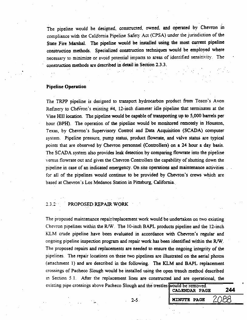
The pipeline would be designed, constructed, owned, and operated by Chevron in compliance with the California Pipeline Safety Act (CPSA) under the jurisdiction of the
State Fire Marshal. The pipeline would be installed using the most current pipeline
construction methods. Specialized construction techniques would be employed where
necessary to minimize or avoid potential impacts to areas of identified sensitivity. The
construction methods are described in detail in Section 2.3.3.
Pipeline Operation
The TRPP pipeline is designed to transport hydrocarbon product from Tosco's Avon
Refinery to Chevron's existing #4, 12-inch diameter idle pipeline that terminates at the
Vine Hill location. The pipeline would be capable of transporting up to 5,000 barrels per
hour (BPH). The operation of the pipeline would be monitored remotely in Houston,
Texas, by Chevron's Supervisory Control and Data Acquisition (SCADA) computer
system. Pipeline pressure, pump status, product flowrate, and valve status are typical
points that are observed by Chevron personnel (Controllers) on a 24 hour a day basis.
The SCADA system also provides leak detection by comparing flowrate into the pipeline
versus flowrate out and gives the Chevron Controllers the capability of shutting down the
pipeline in case of an indicated emergency. On site operations and maintenance activities
for all of the pipelines would continue to be provided by Chevron's crews which are
based at Chevron's Los Medanos Station in Pittsburg, California.
2.3.2 . PROPOSED REPAIR WORK
The proposed maintenance repair/replacement work would be undertaken on two existing
Chevron pipelines within the R/W. The 10-inch BAPL products pipeline and the 12-inch
KLM crude pipeline have been evaluated in accordance with Chevron's regular and
ongoing pipeline inspection program and repair work has been identified within the R/W.
The proposed repairs and replacements are needed to ensure the ongoing integrity of the
pipelines. The repair locations on these two pipelines are illustrated on the aerial photos
(attachment 1) and are described in the following. The KLM and BAPL replacement
crossings of Pacheco Slough would be installed using the open trench method described
in Section 5.1. After the replacement lines are constructed and are operational, the
existing pipe crossings above Pacheco Slough and the trestles would be removed.CALENDAR PAGE 244
2-5 MINUTE PAGE 2088

BAPL
The BAPL pipeline is owned and operated by Chevron in compliance with the California
Pipeline Safety Act (CPSA) under the jurisdiction of the State Fire Marshal. The pipeline
transports refined petroleum products from Chevron's Richmond Refinery to Chevron's
marketing terminals at Avon, Banta, Sacramento, and San Jose. The proposed repair
work would not increase the maximum design flowrate capacity of the BAPL system.
There are eight sites, all within the pipeline R/W, proposed for construction work which
are shown on the attached aerial photo sheets, CD-0226, and identified as "BAPL" work.
The sites consist of eight replacement sections totaling about 6,000 feet of pipeline. The
total area disturbed by construction on the BAPL would be about 6,300 feet along the R/W.
KLM
The KLM pipeline is owned and operated by Chevron in compliance with the California
Pipeline Safety Act (CPSA) under the jurisdiction of the State Fire Marshal. The KLM
pipeline transports crude oil from the oil fields in Kern County to Tosco's refinery at
Avon and Shell's refinery at Martinez. The proposed repair work would not increase the
maximum design flowrate capacity of the KLM system. There are nine sites proposed for
construction work which are shown on the attached aerial photo sheets, CD-0226, and
identified as "KLM" work. The sites consist of four replacement sections totaling about
2,850 feet of pipeline and five sleeve repair locations totaling about 25 feet along the
pipeline. The total area disturbed by construction on the KLM would be about 3,200 feet
along the R/W.
The proposed replacement/repair work would be of a similar nature to the pipeline
installation portion of the proposed project. The work would be done using the most
current, commonly used pipeline construction methods. Specialized construction techniques would be employed where necessary to minimize or avoid potential impacts to
areas of identified sensitivity. All replacement and repair work would also comply with
CPSA. Both the BAPL and the KLM are monitored by Chevron's SCADA system as
described in Section 3.2.
CALENDAR PAGE
MINUTE PAGE 20892-6
245

2.3.3 PIPELINE CONSTRUCTION METHODS
Pipeline Installation/Replacements
There are eight typical steps involved in the construction of a pipeline, as discussed
below. Figures 2A and 2B illustrate these typical steps in the rural and urban environments.
R/W clearing. This entails preparing a clear and level work area for the operations
to follow. This work is done either by a motor grader in fairly flat areas or by a
bulldozer where the terrain perpendicular to the pipeline is sloping. In the latter case
a level "bench" is excavated to provide a level work area along the pipeline R/W. In
areas designated as wetlands, the top six to 12 inches of topsoil would be removed
first and stock piled separately. One or two pieces of equipment would be needed for
this project.
Trenching. In the existing R/W corridor the trenching would be done by a backhoe.
The trench is excavated approximately six feet deep and about two feet wide. A
trapezoidal cross-section, with side slopes of 1.5 to 1.0 may be required in specific
zones of seismic hazard. The excavated material, or "spoils" is placed on the side of
the trench opposite from the work area. In areas where existing pipelines are above
ground, the excavated material cannot be placed on the opposite side. The material is
placed on the "work" side of the trench and flattened to make a workspace. The
excavated material would be segregated from the stockpile of topsoil. One or two
backhoes or larger track-hoes would be working at different points along the route to
complete the trenching efficiently.
Stringing. This step involves unloading pipe joints from a flatbed trailer and placing
them end to end along the work area. The flatbed truck is usually equipped with a
lifting boom; if not, a small crane will be used to hoist the pipe joints from the trailer.
The pipe joints are lifted from the ground using a "side-boom" tractor, which is
simply a bulldozer with a lifting boom on the side, and placed along the work area.
CALENDAR PAGE
2-7 MINUTE PAGE 2090
246

was. . . .
. . .
.. . . ..hmm." by' ... . .. .
my." . ..
CALENDAMINUTE PAGE 2091
CREATING AND DITCHING PIPE BENDING WELDING WEAING CLEANUP AND GRADINGPAGE AND TYING-IN RESTORATION
HAULING AND LINE.UP PIPE BACKFILLING STRINGING COATING
SOURCE EAT
FIGURE 2A TYPICAL RURAL CONSTRUCTION SPREAD

00 . .- 0 0 0 0
0 0 0 0'0 00 ICE
MINUTE PAGE 1097CALENDAR PAGE
REPAVING
SOURCE: ERT248
BACKFILLING JOINT SPOILWELDING LOWERING IN COATING AND LINE-UP REMOVAL
X-RAY INSPECTION
FIGURE 2B TYPICAL URBAN CONSTRUCTION SPREAD
DITCHING PAVEMENT BREAKING

Welding. The side-boom lifts the pipe and positions the end of the pipe so that it can
be clamped and closely fitted to the end of the adjacent joint of pipe. The welding
crew makes the final alignment and welds the pipe ends together. Once the two
joints are secured, the pipe is supported by wooden skids, the side-boom releases the
joint and the process is repeated. This "mainline" welding crew would probably
consist of one side-boom, a welding truck and a supply truck. Usually it requires
three complete "passes" around the circumference of the pipe to complete each weld.
The first pass is completed by the mainline crew before they move ahead to the next
joint. The other two welding passes are performed by the "final" welding crew
which moves along behind the mainline welding crew. The final welding crew
would probably consist of a welding truck with two or three workers, a supply truck,
and a foreman's truck.
Radiography and field coating. The welds are required to be inspected and graded
according to API guidelines. A radiography, or "X-ray," crew of two workers would follow well behind the welding operations. The X-ray crew works from a single
pickup truck to perform the weld inspections. After the weld has been approved by
the X-ray crew, coating must be applied to the welded joint. On each end of the pipe
joint about four inches of pipe is left uncoated at the factory to allow for the field
welding. This gap in the protective coating is covered using field-applied coating
materials. This is performed by two or three laborers with a pickup truck and
possibly a larger supply truck.
Lowering. Once the protective coating is inspected the pipe is ready to be lowered
into the open trench: Two or three side-booms line up along the pipe string. Each of
the side-booms lifts a section of the pipe string and slowly moves it over to the trench. The pipe is held in a cradle with rollers suspended from the side-boom. As
the side-booms move together along the trench, the pipe is gradually lowered into
place at the bottom of the trench.
Backfilling. Usually the backhoe or bulldozer pushes the spoil material into the
trench over the pipeline. The backfill material is then compacted as required and the
original contour of the work area is restored. The native excavation material is used
for backfill if it does not contain hard material, such as large rocks, that could
damage the pipelines's protective coating. If the native material is not acceptable
then clean material or sand must be hauled in. Backfill of "ball-bearing" sand may beCALENDAR PAGE
MINUTE PAGE2-10 2093 249

required in some specific areas of seismic risk. Compaction may be done with small
manually-operated, gasoline-powered tampers or "wheel rolled" with a backhoe. The
topsoil would then be replaced over the disturbed area and regraded to match the original contours.
Testing and Cleanup. Temporary caps are welded to each end of the new pipeline
and the pipeline is filled with water. Additional water is pumped into the pipeline,
raising the pressure to the specified test pressure which is usually 1.5 to 3 times the
normal operating pressure. Any erosion control mitigation structures are constructed
and re-seeding is done. All trash and construction remnants are collected and
properly disposed of.
Pipeline tie-ins: As a final step the operating pipeline must be shutdown and cut so
the new pipe can be connected, or "tied-in." Tie-ins require a great concentration of
work effort and equipment to minimize the shutdown time of the pipeline. The existing pipe is cut at the beginning and end of the replacement segment. The new
pipe section is fitted and welded to the open end to make the pipeline once again
complete. The old pipe is typically cut into pieces; removed from the ground and
disposed of properly. Caps are welded to the ends of any pipe left in the ground
before it is properly abandoned. A side-boom, a backhoe, two welding trucks, a
vacuum truck, a supply truck and two or three pickup trucks.
Repairs to Existing Pipelines/Sleeves
The procedure for repairs is slightly different, but the same type of equipment is used, as follows:
Excavation. The pipeline is exposed using a backhoe to dig a trench over the
pipeline. Since many of the repair operations require personnel to be in the trench,
OSHA standards for trench shoring or sloping are followed. This procedure would
require a delivery truck to bring the shoring materials to the jobsite.
Repairs. Some pipe repairs are made by welding full encirclement sleeves to the
existing pipeline. The procedure requires a Welder and three to five laborers to fit
the sleeve material to the pipeline and weld it into place. The welding truck, a
backhoe, a supply truck and two or three pickup trucks would be at a repair location. CALENDAR PAGE 250
2-11 MINUTE PAGE 2094

Completion. After the welding is done, protective coating is applied to the sleeved
area. Backfilling and cleanup would then be done as described above.
It should be noted that if the repair area is longer than about ten feet it is probably too
long to be sleeved and a new piece of pipe would need to be installed. In this case the
pipe replacement procedure would be followed.
Horizontal Directional Drilling Methodology
An alternative to the proposed project would include horizontal directional drilling
(HDD) underneath the Walnut Creek flood control channel. A detailed description of the
HDD construction methodology, including figures, is included in Attachment 2.
CALENDAR PAGE
MINUTE PAGE 2-12 2095
251

3.0
OIL SPILL CONTINGENCY
Chevron has prepared an Oil Spill Contingency Plan in the event that a construction-
related mishap results in the puncture of an active pipeline. Chevron has prepared facility
Oil Spill and Emergency Response Manuals, containing detailed procedures, in
compliance with the federal Oil Pollution Act of 1990 (OPA). Chevron has subsequently
revised these to comply with the California Oil Spill Prevention and Response Act (SB 2040).
The lines adjacent to the construction site contain both crude and refined products. Every
reasonable precaution would be taken to protect the integrity of the pipeline, but should a
leak occur, the following procedures would be implemented.
OIL SPILL CONTINGENCY PLAN:
NOTIFICATION RESPONSE STRATEGY .
ORGANIZATION OF IMMEDIATE RESPONSE TEAM AVAILABLE OIL RESPONSE EQUIPMENT (RESOURCES)
NOTIFICATION
Notification is essential to ensure rapid shut down of operating pipelines, initiate
emergency response and to notify affected parties and governmental agencies. As
such, on site personnel will be radio equipped. In the event of a spill, notification should occur as follows:
Immediately notify all site personnel to shut down equipment and evacuate the Immediate spill scene until the source and size of the spill can be ascertained.
. Immediately contact the control center to shut down pipeline flow in the right of way.
Notify the Los Medanos Natural Team to block in the line to minimize drain down.
Begin notification of spill response personnel. CALENDAR PAGE
MINUTE PAGE3-1 2096 252

. Contact Governmental agencies: USCG National Response Center (800) 424-8802 California Office of Emergency Services (800) 852-7550
Notify Company management
RESPONSE STRATEGY
In the event of a minor spill, (< 1 barrel, no impact to water or wildlife) the following
steps should be taken:
. Notify the Control Center to shut down the line using on site radio Notify the local operations personnel to block in damaged area. Make proper notifications
. . Activate local Operations Team Spill Response Personnel
In the event of a significant spill (> 1 barrel, impacts wildlife or water) the following
steps should be taken:
Notify the Control Center to shut down the line Notify the local operations personnel to block in damaged area
Make proper notifications. . . Activate local Operations Team Spill Response Personnel
Activate spill response contractors and equipment
Evaluate situation to determine if additional resources are necessary
Equipment Availability
During the construction phase of this project that could impact other active lines, the
Los Medanos Natural Team Spill Response Equipment Trailer will be stationed at
the Avon Terminal, which is located within 10 minutes drive of the project. The
Spill Response Equipment Trailer contains the following:
Sorbent Pads Sorbent Booms Shovels, rakes, etc. Portable lighting
Personal Protective Equipment. Plastic Bags Plastic Sheeting
CALENDAR PAGE
MINUTE PAGE3-2 2097
253

Rags
Storage Drums
In the event additional equipment is necessary, Chevron Pipeline Company has a
memorandum of understanding with the Chevron Richmond Refinery which allows
for 24 hour access to any of their equipment in the event of an emergency.
The potential for a spill to water is to be avoided by constructing in the right-of-way
during a period when Pacheco Slough is dry. The early detection of any construction-related leaks will be enhanced by the presence of field inspectors
equipped with radios for contacting Chevron's pipeline Control Center for immediate shut-down of pipelines and dispatch of response personnel. In the event
of an accident, the construction-related equipment will be available on site to dam or
otherwise restrict the movement of accidentally leaked materials.
CALENDAR PAGE
MINUTE PAGE3-3 2098 254

4.0
ENVIRONMENTAL FACTORS
The following discussion of environmental factors is organized in accordance with the
Environmental Checklist Form contained in the current CEQA Guidelines." The potential
for the project to cause adverse impacts to the environment is discussed for each environmental factor. In addition, the measures which Chevron includes as part of the
proposed project in order to reduce any potentially significant impacts to less-than-
significant are described. The discussion of environmental factors begins with Land Use
and Planning, in the following.
4.1 LAND USE AND PLANNING
Would the proposal: a) Conflict with general plan designation or zoning; b) Conflict with applicable environmental plans or policies adopted by agencies with jurisdiction over the project; c) Be incompatible with existing land use in the vicinity; d) Affect agricultural resources or operations (e.g. impacts to soils or farmlands, or impacts from incompatible land uses); e) Disrupt or divide the physical arrangement of. an established community (including a low-income or minority community)?
The project area is located in the boundaries of the Contra Costa County General Plan
1990-2005. This Plan was adopted by the County Board of Supervisors in January 1991.
(revised March 11, 1991). The land use designation and zoning of the upland lands
adjacent to the State Lands property is Heavy Industrial. Land uses adjacent to other
portions of the project R/W include Light Industrial, Commercial, Residential, and General Agriculture.
The project consists of pipeline installation and repairs within an existing R/W. As such,
continued use of these lands would not conflict with the applicable plans, nor would it
affect agricultural resources or the established community in the project area. The
proposed project is compatible with the existing land use in the area, and would not
require a variance from the existing zoning or amendment to the applicable plans.
CALENDAR PAGE
MINUTE PAGE4-1 2099
255

It should be noted that Chevron has consulted with all adjacent landowners and tenants
along the project R/W regarding the proposed project. Chevron is currently working
cooperatively with these parties to address the specific issues raised during the
consultation process. A complete summary of the consultation process and resolution of
concerns is provided in Section 5.0.
4.2 POPULATION AND HOUSING
Would the proposal: a) Cumulatively exceed official regional or local population projections; b) Induce substantial growth in an area either directly or indirectly (e.g. through projects in an undeveloped area or extension of major infrastructure); c) Displace existing housing. especially affordable housing?
The proposed project would not induce any short-term or long-term growth in the area,
nor would it displace existing housing. The project involves installation and repair work
within an existing pipeline R/W which does not cross residential areas. In addition, the
construction and operation of the pipelines would be carried out utilizing the local labor force.
4.3 GEOLOGIC PROBLEMS
Would the proposal result in or expose people to potential impacts involving: a) Fault rupture; b) Seismic ground shaking; c) Seismic ground failure, including liquefaction; d) Seiche, tsunami, or volcanic hazard; e) Landslides or mudflows; f) Erosion, changes in topography or unstable soil conditions from excavation, grading, or fill; g) Subsidence of the land; h) Expansive soils; i) Unique geologic or physical features?
The pipeline traverses relatively flat to gently sloping terrain. Elevations along the
pipeline route range from a high of 20 feet above mean sea level (MSL) near Avon and
Vine Hill to a low of four feet above MSL near Pacheco Creek. The land surface near
Vine Hill slopes gently eastward, toward the topographic low at Pacheco Creek. Similarly, the land surface near Avon slopes westward, toward Pacheco Creek
The Soil Conservation Service (SCS) has mapped eight distinct soil types along the
pipeline alignment, as follows: Capay clay; Omni silty clay; Dibble silty clay foam, Alo CALENDAR PAGE
MINUTE PAGE4-2 2100
256

clay; Millsholm loam; Tierra loam; Clear Lake clay: and Positas loam. Capay clay
occurs on moderately sloping to gently sloping benches near the Avon terminal and Omni
silty clay occurs along the low edges of flood plains near Pacheco Creek, Maltby, and
Highway 680. Alo clay, Dibble silty clay loam, Millsholm loam, Tierra loam and Positas
loam occur on the smooth hills, uplands, and terraces between Maltby and Vine Hill.
Clear Lake clay occurs near Vine Hill where the water table is below 60 inches. These
soil types are described in the SCS Soil Survey of Contra Costa County (1977) as having
the following properties related to soil stability. First, runoff ranges from slow to
medium in all of the soil types except Omni and Clear Lake where runoff is very slow.
Omni soil is subject to occasional flooding due to its very slow runoff and Clear Lake
clay is subject to flooding every seven to ten years, unless surface drainage is provided.
Second, the hazard of erosion ranges from slight to moderate where soils are bare or
exposed, except in Omni and Clear Lake soils, which are not subject to erosion. Finally,
the majority of soils along the pipeline route have moderate to high shrink-swell potential.
The San Francisco Bay region is traversed by three major active faults. From west to east
these are the San Andreas Fault, the Hayward Fault and the Calaveras Fault. In addition,
at least seven minor active or potentially active faults have been identified in the region.
These include: the Healdsburg-Rodgers Creek fault zone; the Maacama Fault; the Green
Valley Fault; the Concord Fault; the Greenville Fault; and the Clayton-Marsh Creek
Fault. Of these, the San Andreas, Hayward, and Calaveras faults are considered to have
the highest potential for large earthquakes. These faults are capable of producing
maximum credible earthquakes of magnitude of 8.5, 7.5, and 7.0, respectively. In addition, the Concord Fault crosses the existing pipeline RAW and poses a potential threat
in the event of a seismic event. The Concord Fault is considered to be well defined and
has shown displacement in the last 200 years. Consequently, the State Geologist has
delineated the fault and all areas within a quarter mile of the fault as a Special Study Zone
in accordance with the Alquist-Priolo Earthquake Fault Zoning Act. This designation
prohibits the location of developments and structures for human occupancy across the
trace of the fault.
The active and potentially active faults in the Bay area are capable of generating
earthquakes with sufficient magnitude to cause strong ground motion in the project area
and damage to the pipeline. Substantial damage to the pipeline as a result of ground
rupture or strong ground shaking would be a potentially significant adverse ienact. To 257
MINUTE PAGE 4-3 2101
reduce these potential impacts to a less-than-significant level, the pipeline would be designed and constructed in a manner consistent with the requirements of the County of
Contra Costa General Plan, Seismic Safety Element. In addition, Chevron has prepared
an Emergency Response Manual that would be implemented in the event of an
earthquake or rupture of the pipeline. The Response Manual was prepared in compliance
with the federal Oil Pollution Act of 1990 (OPA), and then revised to comply with the California Oil Spill Prevention and Response Act (SB 2040).
The minor excavation associated with the proposed project and the types of soils present
are such that the project would not result in or expose people to potential impacts
involving subsidence, unstable soil conditions, expansive soils, or other hazards such as
landslides and mudflows. Also, no unique geologic or physical features occur within the
proposed project area. Although the hazard of erosion is only slight to moderate in the project area, increased erosion could potentially occur during the construction phase of
the project. As such, the following best management practices incorporated into the
project would minimize any such effects. The soils disturbed by construction compaction would be backfilled as soon as practicable following the installation of or
repairs to the pipe. The compaction of the backfill would approximately replicate the
original drainage conditions of the disturbed soils. Dust control measures would also be
implemented during the construction period to alleviate adverse downwind effects.
In addition, the US Army Corps of Engineers has authorized construction activities for
the proposed project under a Nationwide Permit No. 12, Utility Corridor, pursuant to
Section 404 of the Clean Water Act. Under the nationwide permit, Chevron must
conduct all construction activities in compliance with the General Conditions specified
by the Corps. These conditions include the use and maintenance of appropriate erosion
and siltation controls during construction; the permanent stabilization of all exposed soil
and other fills at the earliest practicable date; and, in wetlands, the placement of heavy
equipment on mats, or other measures to minimize soil disturbance.
CALENDAR PAGE
4-4 MINUTE PAGE 2102
258

4.4 WATER
Would the proposal result in: a) Changes in absorption rates, drainage patterns, or the rate and amount of surface runoff; b) Exposure of people or property to water related hazards such as flooding; c) Discharge into surface waters or other . alteration of surface water quality (e.g. temperature, dissolved oxygen, or turbidity)? d) Changes in the amount of surface water in any water body; e) Changes in currents, or the course or direction of water movements; f) Change in the quantity of ground waters, either through direct additions or withdrawals, or through interception of an aquifer by cuts or excavations or through substantial loss of groundwater recharge capability; g) Altered direction or rate of flow of groundwater; h) Impacts to groundwater quality; i) Substantial reduction in the amount of groundwater otherwise available for public water supplies?
The two waterways in the project area are Walnut Creek and Pacheco Slough. Walnut
Creek is a dredged flood control channel owned and maintained by the Contra Costa
Flood Control District. Pacheco Slough is currently a highly degraded seasonal waterway. No water was present in Pacheco Slough at the time of this report (summer
1995).
The proposed project would not result in changes in absorption rates, drainage patterns or
the amount or rate of surface runoff. The project involves work within an existing
pipeline R/W. Upon completion of construction, the R/W would be restored to pre-
existing conditions. The proposed project would not involve flooding or changes in surface water currents.
The proposed project would not result in alteration of the surface water quality in the
project area. The Bay Area RWQCB has granted a waiver of Section 401 Water Quality
Certification for this project (by letter dated July 24, 1995; see Attachment 3). In
addition, the US Army Corps of Engineers has authorized construction activities for the
proposed project under a Nationwide Permit No. 12, Utility Corridor, pursuant to Section
404 of the Clean Water Act. In order to further protect the waters of the United States,
Chevron must conduct all construction activities in compliance with the General
Conditions specified by the Corps. These conditions are intended to minimize any
potential effects on water quality associated with earthmoving or other construction
activities. The requirements include the use and maintenance of appropriate erosion and
siltation controls during construction; the permanent stabilization of all exposed soil andCALENDAR PAGE 259
4-5 MINUTE PAGE 2103

other fills at the earliest practicable date; and. in wetlands, the placement of heavy
equipment on mats, or other measures to minimize soil disturbance.
It should be noted that Chevron has consulted with the CDFG in order to obtain a
Streambed Alteration Agreement for the proposed project. Chevron would implement the
project in strict accordance with the specific provisions of the Agreement in order to
further protect the aquatic environment in the vicinity of Walnut Creek and Pacheco
Slough. The provisions of the Agreement include a requirement to conduct all field work
in the Pacheco Slough waterway prior to October 15th. Construction may continue past
October 15th at Walnut Creek, but Chevron would be required to consult with CDFG on
a daily basis after this date.
Chevron's Oil Spill and Emergency Response Manuals were prepared in recognition of
the potential impairment of surface water and groundwater quality in the event of an
accidental release. The manuals were prepared in compliance with the federal Oil Pollution Act of 1990, and were then revised to comply with the California Oil Spill
Prevention and Response Act (SB 2040). The manuals include specific procedures for
the following: 1) notification; 2) response strategy; 3) organization of emergency
response team; and 4) available oil spill response equipment. Adherence to the provisions of these manuals will minimize the potential adverse water quality effects of an accidental release.
The use of horizontal directional drilling beneath Walnut Creek could result in a release
of drilling mud or bentonite if not properly managed. . Most subsurface releases will be
self-sealing and will not adversely impact groundwater resources. If muds from the
subsurface move upward and enter Walnut Creek, there could be excessive turbidity. The.
HDD methodology described in Section 2.3 will be conducted so as to minimize the
possible discharge of drilling muds to surface water. In particular, continuous reading of
azimuth and inclination, as well as survey stations taken every 15 feet, will ensure that
the pilot hole and reamed hole are kept along the design pathway.
CALENDAR PAGE
MINUTE PAGE4-6 2104
260
4.5 AIR QUALITY
Would the proposal result in: a) substantial air emissions or deterioration of ambient air quality; b) the creation of objectionable odors; c) alteration of air movement, moisture, or temperature, or any change in climate, either locally or regionally?
The relatively small and localized effects of the proposed pipeline installation and repair
are such that no significant changes in air movement, moisture, temperature, or climate
are expected either locally or regionally. The project construction could, however,
potentially create short-term adverse but not significant air emissions.
A brief discussion of the relevant air quality-related regulatory requirements and the
results of the modeling as it relates to these regulatory requirements are presented in the
following.
Contra Costa County is part of the Bay Area Air Basin (BAAB) and, therefore, all projects with potential air emissions located within this county, including the proposed
project, need to comply with the regulatory requirements of the Bay Area Air Quality
Management District (BAAQMD). BAAQMD has set forth guidelines for assessing
impacts of project and plans. According to the BAAQMD's guidelines, any project with
potential air pollutant emissions above the threshold levels established by the BAAQMD
would have a potentially significant air quality impact and as such would need to
implement the appropriate mitigation measures to reduce the impacts below the threshold
levels to the extent feasible.
The significance threshold for Carbon Monoxide (CO) is set at 550 pounds per day. Each
of the other criteria pollutants (Oxides of Nitrogen (NO,), Reactive Organic Compounds
(ROC), Sulfur Oxides (SO,), and Particulate Matter (PM) has a significance threshold of
150 pounds per day. Any project resulting in air emissions exceeding these thresholds
would have a potentially significant air quality impact.
In order to characterize and quantify the air emissions associated with the proposed
construction activities, methodologies prescribed by the BAAQMD and the United States
Environmental Protection Agency (EPA) were used. Attachment 4 of this document
presents the assumptions as well as estimation techniques used to quantify air emissions
CALENDAR PAGE 261
MINUTE PAGE 4-7 2105

associated with both disturbance of soil as well as operation of the construction
equipment. The list of construction-related equipment is included on the following page.
The modeling results, as detailed in Attachment 4, indicate that the operation of the
construction equipment would not result in any exceedence of the BAAQMD's significance thresholds. However, daily watering of the active construction site would be
required to avoid potentially significant particulate matter emissions associated with soil. disturbance.
In conclusion, with the proposed watering to control particulates, the proposed project
construction would not exceed any BAAQMD's significance thresholds and as such
would not result in any adverse significant impact.
4.6 TRANSPORTATION/CIRCULATION
Would the proposal result in: a) Increased vehicle trips or traffic congestion; b) Hazards to safety from design features (e.g. sharp curves or dangerous intersections) or incompatible uses (e.g. farm equipment); c) Inadequate emergency access or access to nearby uses; d) Insufficient parking capacity on-site or off-site; e) Hazards or barriers for pedestrians or bicyclists; f) Conflicts with adopted policies supporting alternative transportation (e.g. bus turnouts, bicycle racks); @) Rail, waterborne or air traffic impacts?
Transportation corridors in the vicinity of the project area include Solano Way, the
Southern Pacific Railroad, the AT&SF Railroad, Highway 680, and Pacheco Boulevard.
Solano Way and Pacheco Boulevard are maintained by the County of Contra Costa,
whereas Highway 680 is maintained by the California Department of Transportation
(CalTrans). Pacheco Boulevard is a regional arterial, providing important intercounty
and/or interregional traffic connections. Solano Way and other roads in the immediate
area consist primarily of low-speed, low-capacity local roads providing circulation within
the neighborhood and nearby areas. The Southern Pacific and AT&SF railroad lines
serve as freight transportation routes through the project area.
CALENDAR PAGE 262
4-8 MINUTE PAGE 2106

LIST OF EQUIPMENT
PROPOSED AVON TO VINEHILL PIPELINE PROJECT
2 each 561 Side Booms
1 each D7 Dozer/Winch
1 each 710 RT Backhoe
2 each 580 RT Backhoe
1 each Cat 225 Excavator
1 each K/W Tractor with hydrocrane and floot trailer
1 each Semi-truck with lowbed
2 each 2-Ton Winch Trucks
2 each 1-Ton Trucks
6 each 3/4 Ton Trucks
2 each -175 Air Compressor
1 each 17 Gal Pressure Pump . ..
If necessary, the following equipment would be utilized for directional drilling:
1 each Bore King Model DBS-100 Directional Drilling Machine
CALENDAR PAGE
MINUTE PAGE 2107
263

The maintenance and operation of the pipelines following project completion would not
adversely affect transportation or circulation. Construction-related effects to
transportation and circulation would be limited to short-term increases in traffic congestion, as described further in the following. The list of equipment utilized during
construction is provided in Section 4.5, Air Quality.
The proposed project includes limited construction activities within the rights-of-way of
the SP and AT&SF Railroads near Solano Way and Pacheco Slough, respectively.
Although construction activities would not affect normal operations of the railroads,
Chevron would provide adequate notification to these companies prior to construction.
Chevron's existing R/W crosses underneath Highway 680 near Pacheco. The proposed
project would include the installation of new pipe within this crossing. Normal operations of the Highway would not be affected by this work. However, Chevron has
notified CalTrans of the planned work in accordance with the existing consent to Common Use Agreement between Chevron and CalTrans.
The proposed project would affect traffic in the vicinity of Pacheco Boulevard and
Solano Way during the construction phase. The disruptive effects of the pipeline
construction activities in the vicinity of these roads would include: 1) excavation and
construction adjacent to the road; 2) construction equipment and personnel use of the
road shoulder, 3) excavation and construction across Pacheco Boulevard; 4) temporary
blocking of one traffic lane during the two-day construction period (Pacheco Boulevard);
and 5) increased traffic related to the pipeline construction activities. Chevron is
currently working with the Contra Costa County Planning Department to determine the
County's specific requirements to ensure public safety during the construction phase of
the project. The detailed traffic plan would be finalized by Chevron's construction
contractor and submitted to the County prior to construction.
CALENDAR PAGE
MINUTE PAGE4-10 2108
264

4.7 BIOLOGICAL RESOURCES
Would the proposal result in impacts to: a) Endangered, threatened or rare species or their habitats (including but not limited to plants, fish, insects, animals, and birds); b) Locally designated species (e.g. heritage trees); c) Locally designated natural communities (e.g. oak forest, coastal . habitat, etc.); d) Wetland habitat (e.g. marsh, riparian, and vernal pool); e) Wildlife dispersal or migration corridors?
General biological surveys were conducted for the project corridor during December
1994, and February and April 1995. In general, the existing R/W was found to be highly
disturbed, containing vegetation and wildlife that reflect this condition. Typical freshwater marsh_vegetation occurs along Walnut Creek, including cattails, California
bulrush and broad-leaved peppergrass. At Pacheco Slough, a mixture of both upland and
wetland vegetation occurs including mustard, poison hemlock, wild radish and thistle
interspersed with saltgrass, pickleweed and spike rush. A 200-meter long wetland area
occurs just east of Highway 680 which supports predominantly cattails. West of Highway 680, little vegetation occurs other than scattered ruderal species and urban
landscape species. Habitat values are generally low; most of this habitat is used only by
animal species adapted to disturbed conditions and urban landscapes. Animal species
observed in the vicinity of the R/W include Brewer's blackbird, red-winged blackbird,
American kestrel, white-crowned sparrow, house finch, pied-billed grebe, red-tailed
hawk, western meadow lark, black phoebe, and goldfinch.
A California Natural Diversity Database (CNDDB) records search conducted on April 5,
1995, indicated that the California clapper rail, California black rail, and Salt marsh
harvest mouse could occur in the vicinity of the project. Biological surveys conducted in
December, February, and April of 1995 indicated that no habitat for the California
clapper rail would be affected by the proposed project. Detailed surveys were conducted
for the California black rail during February and April to assess marginal habitat found in
the vicinity of Walnut Creek and Pacheco Slough. The surveys were conducted in
consultation with the California Department of Fish and Game (CDFG). No black rails
were found during these surveys. A comprehensive trapping survey was conducted for
the Salt marsh harvest mouse in July 1995. The survey was conducted in consultation
with CDFG and the US Fish and Wildlife Service (USFWS). No Salt marsh harvest mice
were found during the survey.
CALENDAR PAGE 265
MINUTE PAGE 21094-11

Results of the surveys conducted in consultation with the agencies indicate that the
proposed project would not result in impacts to threatened or endangered species. The
proposed project would not result in impacts to locally-designated species, natural
communities, or wildlife dispersion or migration corridors.
The proposed project would affect several areas of wetlands during the eight to ten week
construction period. Potential impacts to the wetlands would be reduced to less than
significant as described in the following. Chevron consulted with the San Francisco
District of the US Army Corps of Engineers regarding the proposed project. The Corps
authorized construction activities for the proposed project under a Nationwide Permit No.
12, Utility Corridor, pursuant to Section 404 of the Clean Water Act (by letter dated June
6, 1995; see Attachment 3). Under the nationwide permit, Chevron must conduct all
construction activities in compliance with the General Conditions specified by the Corps.
These conditions are intended to minimize any potential effects on waters of the United
States associated with earthmoving or other construction activities. The requirements
include the use and maintenance of appropriate erosion and siltation controls during
construction; the permanent stabilization of all exposed soil and other fills at the earliest
practicable date; and, in wetlands, the placement of heavy equipment on mats, or other
measures to minimize soil disturbance.
It should be noted that Chevron consulted with the CDFG in order to obtain a Streambed
Alteration Agreement for the proposed project. A visit to the proposed project site was
conducted with Warden Nicole Kozicki of the Region 3 office on August 9, 1995. The
Agreement will be finalized during the week of August 14, upon Chevron's submittal of
the completed application. Chevron would implement the project in strict accordance
with the specific provisions of the Agreement in order to further protect the biological
resources in the vicinity of Walnut Creek and Pacheco Slough. According to the results
of the field meeting, the provisions would include the requirement to conduct all field
work in the Pacheco Slough waterway prior to October 15. Construction may continue
past October 15 at Walnut Creek, but Chevron would be required to consult with CDFG
on a daily basis after this date.
CALENDAR PAGE
MINUTE PAGE4-12 2110
266

4.8 ENERGY AND MINERAL RESOURCES
Would the proposal: a) Conflict with adopted energy conservation plans; b). Use non-renewable resources in a wasteful and inefficient manner; c) Result in the loss of availability of a known mineral resource that would be of future value to the region and the residents of the State?
The proposed pipeline reoperation and repair project would not conflict with adopted energy conservation plans and would not result in the use of non-renewable resources in
a wasteful or inefficient manner. Implementation of the proposed project would not
result in the loss of availability of any known mineral resource of future regional or statewide value. Minor amounts of fuel would be required for trucks, bulldozers and
other equipment during the eight to ten week construction phase. Operation of the
completed project would allow the continued safe, efficient transport of hydrocarbon
product to the marketplace.
4.9 HAZARDS
Would the proposal involve: a) A risk of accidental explosion or release of hazardous substances (including, but not limited to: oil, pesticides, chemicals or radiation); b) Possible interference with an emergency response plan or emergency evacuation plan; c) The creation of any health hazard or potential health hazard; d). Exposure of people to existing sources of potential health hazards; e) Increased fire hazard in areas with flammable brush, grass, or trees?
The proposed project would not interfere with an emergency response or evacuation
plan. No roadways, or emergency corridors would be blocked during the eight to ten week construction period.
Risk of Upset. The proposed project involves repair and installation work within an
existing pipeline R/W. The existing pipelines would continue to be operated while the
new construction is being accomplished. The operation would then be shutdown, the
new sections would be tied in, and operations would be restarted while the old sections of
pipe are removed. Chevron would take every precaution to conduct the construction
using the most current methods available. Radio-equipped field inspectors will be on site
during the construction period. In addition, the operation of the pipelines will be
monitored remotely in Houston, Texas, by Chevron's Supervisory Control and Data
CALENDAR PAGE 267
4-13 MINUTE PAGE 2111

Acquisition (SCADA) . computer system. Pipeline pressure, pump status. product
flowrate, and valve status are typical points that are observed by Chevron personnel
(Controllers) on a 24 hour a day basis. The SCADA system also provides leak detection
by comparing flowrate into the pipeline versus flowrate out and gives the Chevron
Controllers the capability of shutting down the pipeline in case of an indicated emergency. On site operations and maintenance activities for all of the pipelines will continue to be provided by Chevron's crews which are based at Chevron's Los Medanos
Station in Pittsburg, California.
While the risk of an explosion or any other upset conditions is extremely low, the remote
potential exists for the release of hazardous substances into the environment. In the event
of an accident, Chevron would proceed in accordance with the project-specific Oil Spill
Contingency Plan described in Chapter 3.0. Procedures and equipment for major and
minor spill events are outlined in Chevron's Oil Spill Contingency Plan, prepared in
compliance with the federal Oil Pollution Act of 1990 (OPA) and subsequently revised in
compliance with the California Oil Spill Prevention and Response Act (SB 2040).
Contaminated Soils. Due to the highly industrialized nature of the project corridor, the
potential exists for contaminated soils to be encountered during excavation. In the event
oil contaminated soils are encountered, the following steps would be taken to ensure . worker protection:
Immediately stop all work Contact Chevron Pipeline Inspector
. The Chevron Inspector will monitor the air at the work site for the following: Benzene
Total Hydrocarbons
In the event Benzene is detected, the following precautions would be taken:
All personnel working in the immediate are who could be exposed to the benzene must wear half mask organic vapor respirators. If levels exceed 10 PPM, full face organic respirators must be worn.
If levels exceed 50 PPM (very unlikely), supplied air respirators must be worn.
If no benzene is detected, but hydrocarbon levels exceed 300 PPM, half-mask organic
vapor respirators must be worn by all workers in the immediate area-
CALENDAR PAGE 268
4-14 MINUTE PAGE 2112

Monitoring should continue at adequate intervals to ensure that levels are not increasing
as work progresses. Monitoring results should be recorded and files maintained for a period of one year.
Workers should avoid skin contact with contaminated soil. This may be accomplished by
wearing cover all or tyvek suits. Oil resistant gloves should also be worn if there is a possibility of skin contact.
ACM Handling Requirements. Portions of the pipeline proposed for removal contain a
small percentage of asbestos in the somastic coating or "P" wrap attached to them. As
such, Chevron proposes to meet all applicable Asbestos Containing Material (ACM)
handling requirements during construction. ACM compliance requirements are a combination of air, waste, and safety regulations administered by the Bay Area Air
Quality Management District, the California Department of Toxic Substances Control
(DTSC) and Cal OSHA, respectively. The ACM removal and handling requirements for
these agencies are summarized in a table on the following page. A detailed flow chart
outlining the procedures is provided in Attachment 5.
4.10 NOISE
Would the proposal result in: a) Increases in existing noise levels; b) Exposure of people to severe noise levels?
The project area is characterized as highly industrial in nature. The primary sources of
noise in the vicinity include: 1) the Tosco"Avon Refinery, 2) the Southern Pacific and
Atchison Topeka and Santa Fe Railroads, 3) Highway 680, and 4) Buchanan Field, near
Concord, and 5) general traffic in the vicinity of Pacheco Boulevard and Arthur Road.
As a result, areas adjacent to the proposed construction corridor presently experience high
noise levels, and short-term construction-related noise would not substantially increase
the existing ambient noise. The noise produced during the eight- to ten-week construction period would be partially masked by refinery, railroad and highway noise in the immediate area.
In addition, no noise-sensitive land uses (residences, schools, hospitals) exist in proximity
to the proposed project corridor. As such, the proposed project would not result in exposure of people to severe noise levels.
CALENDAR PAGE
MINUTE PAGE 21134-15
269

ACM HANDLING REQUIREMENTS SUMMARY
MASTIC AGENCY P WRAP
CONDITION
Any condition Cal OSHA
Any condition California DTSC
Good condition Bay Area
AQMD
Poor Condition Bay Area
(crumbling) AQMD
Poor Condition Bay AreaMINUTE RAGECALENDARS PAGE(eramoting) AQMD
NOTIFICATION & REPORTING
Courtesy phone call prior to starting job.
NONE
NONE
NONE if Less than 100 linear feet or 100 sq. ft. or 35 cu. ft. of ACM removed from pipe.
If Greater than 100 linear feet or 100 sq. ft. cu. ft. or 35 cu. A. of ACM removed from pipe then submit written BAAQMD notification form and fee payment required at least 10 WORKING DAYS IN ADVANCE. If original work schedule changes additional notifications are required.
plete Procedures Are Contained in Attachment 5
270
PROCEDURES *
Wet material prior to removing and keep wet until placed in double lined asbestos bag according to attached procedure
Bag must have OShiA asbestos warning label. Place in double lined ACM bag
Label as Nonhazardous waste asbestos along with OSHA asbestos warning label
Complete a nonhazardous bill of lading, send original with transporter, and retain a copy.
Follow procedures above for Cal OSHA and DTSC
Follow procedures above for Cal OSHA and DTSC
Hire a California licensed asbestos removal
contractor. Contractor to follow all procedures for Cal OSHA, DTSC, and the BAAQMD.
RECORD-KEEPING
NONE
Retain non-hazardous bill of lading on file for a years.
Complete BAAQMD ACM notification form and retain Do Not submit to AQMD
Complete BAA ACM notification form and retain Do Not submit to AQMD Retain copy of BAAQMD notification form for 2 years.

4.11 PUBLIC SERVICES
Would the proposal have an effect upon, or result in a need for new or altered government services in any of the following areas: a) Fire protection; b) Police protection; c) Schools; d) Maintenance of public facilities, including roads;. e) Other governmental services?
The proposed project consists of the installation of an underground pipeline along an
existing R/W, and the repair/replacement of existing underground pipelines within the R/W. As such, the proposed project would not have an effect upon, nor would it result in
a need for new or altered government services including fire or police protection, schools,
or maintenance of public facilities. The pipelines within the existing R/W would require
no additional public service support for daily operation. The local fire departments are
fully equipped and staffed to protect commercial and industrial land uses in the area.
Chevron will submit the appropriate documentation to the Contra Costa County Consolidated Fire District regarding the reoperation of the TRPP. Notification would be
provided to the Office of the State Fire Marshal.
4.12 UTILITIES AND SERVICE SYSTEMS
Would the proposal result in a need for new systems or supplies, or substantial alterations to the following utilities: a) Power or natural gas; b) Communications systems; c) Local or regional water treatment or distribution facilities; d) Sewer or septic tanks; e) Storm water drainage; f Solid waste disposal; g) Local or regional water supplies?
The proposed project consists of the installation of an underground pipeline along an
existing R/W, and the repair/replacement of an existing underground pipeline within the
R/W. As such, the proposed project would not result in a need for new power, natural
gas, or communications systems. Furthermore, no additional water treatment or
distribution facilities, sewers, septic tanks, storm water drainage facilities, solid waste
disposal facilities, or water supplies would be necessary as a result of project implementation.
The general pipeline construction contractor will be responsible for the disposal of
miscellaneous trash and debris from the construction operation at appropriate dump sites.
CALENDAR PAGE
MINUTE PAGE 21154-17
271

4.13 AESTHETICS
Would the proposal: a) Affect a scenic vista or scenic highway; b) Have a demonstrable negative aesthetic effect; c) Create light or glare?
The proposed project would not affect a scenic vista or have a negative aesthetic effect.
The project would involve the continued use of an existing pipeline R/W. The visual
character of much of the R/W is highly industrial in nature, reflecting the land uses on
and around the project site. The Atchison, Topeka and Santa Fe (AT&SF) railroad alignment is the main visual feature of the eastern two-thirds of the project site; views of
the western third of the site primarily encompass Pacheco Boulevard and parking lots.
Surrounding views are slightly more diverse. At the eastern end, foreground views
consist primarily of the AT&SF railroad tracks, while the tanks and processing facilities
of Tosco's Avon Refinery dominate middle- and background views. Near Walnut Creek,
the visual quality remains low, with flat, undeveloped areas, salt ponds, and high-voltage
electrical transmission lines and towers comprising the predominant visual elements.
West of Highway 680, the R/W leaves the railroad line to traverse an area characterized
by low-rise office and industrial uses in the foreground and middle-ground, with rolling
to steep hills visible in the background.
The project would not create light or glare. Construction activities would be carried out.
during daylight hours and would not require special lighting. The completed pipelines
would be buried.
4.14 CULTURAL RESOURCES
Would the proposal: a.) Disturb paleontologist resources; b) Disturb archaeological resources; c) Affect historical resources; d) Have the potential to cause a physical change which would affect unique ethnic cultural values; e) Restrict existing religious or sacred uses within the potential impact area?
Chevron consulted with the Northwest Information Center at Sonoma State University
regarding cultural resources in the project area. The following information is adapted
from the Information Center's recommendations letter to Chevron, dated July 3, 1995 (a
complete copy of which is contained in Attachment 3).
CALENDAR PAGE
4-18 MINUTE PAGE 2116 272

A review of records and literature on file at the Information Center indicated that the
proposed project area contains no recorded Native American cultural resources listed with
the California Archaeological Inventory. State and Federal Inventories list no historic
properties in the project area. Native American archaeological sites in this portion of
Contra Costa County tend to be situated on historic bay margins and marshes, as well as
on alluvial flats near sources of fresh water. The project area encompasses all three of the
aforementioned ectones. Given the environmental setting of the project area, there is a
high potential for Native American sites in the project area.
Review of historic literature and maps on file at the Northwest Information Center
indicated that there were homesteads along Pacheco and Walnut Creeks (GLO 1858 &
1864). With this in mind, there is a moderate possibility of historic cultural resources in
the project area. . . .
The Information Center's recommendations are as follows:
1) There is a possibility of Native American and historic cultural resources in the project
area. The project area has been previously disturbed by pipeline, road and railroad
construction to a depth of several inches. The current project will impact mostly the areas
that have been previously disturbed, therefore further archival and field study by an
archaeologist is not recommended at this time.
2) Review for possible historic structures has included only those sources listed in the
attached "bibliography and should not be considered comprehensive with respect to
architecture. The Office of Historic Preservation has determined that buildings and.
structures 45 years or older may be of historic value. If the project area contains such
properties, they should be evaluated, prior to commencement of project activities.
3) Please keep in mind that there is a possibility of buried cultural resources in the
project area. If cultural resources are encountered during the project, avoid altering the
materials and their context until a cultural resource consultant has evaluated the situation.
Project personnel should not collect cultural resources. Prehistoric resources include
chert and obsidian flakes, projectile points, mortars, and pestles, and dark friable soil
containing shell and bone dietary debris, heat-affected rock, or human burials. Historic
resources include stone or adobe foundations or walls; structures and remains with square
nails; and refuse deposits, often in old wells and privies. CALENDAR PAGE 273
MINUTE PAGE 21:174-19

4) Identified cultural resources should be recorded on forms DPR 422 (archaeological
sites) and/or DPR 523 (historic properties) or similar forms.
Chevron would conduct the construction phase of the project in strict accordance with the
Information Center's recommendations. As such, the proposed project would not cause
adverse impacts to cultural resources.
4.15 RECREATION
Would the proposal: a) Increase the demand for neighborhood or regional -parks or other recreational facilities; b) Affect existing recreational opportunities?
The proposed project would not increase the demand for parks or other recreational
facilities, nor would it affect existing recreational opportunities. The project area consists
of an existing pipeline R/W in a highly industrialized area of Contra Costa County. No
recreational uses are known to exist in the project area. As such, no impacts are expected.
4.16 MANDATORY FINDINGS OF SIGNIFICANCE
a) Does the project have the potential to degrade the quality of the environment, substantially reduce the habitat of a fish or wildlife species, cause a fish or wildlife population to drop below self-sustaining levels, threaten to eliminate a plant or animal community, reduce the number or
restrict the range of a rare or endangered plant or animal, or eliminate important examples of the major periods of California history or prehistory?
Implementation of the proposed pipeline work in the existing right-of-way would not
degrade the quality of the environment, nor would it reduce fish or wildlife habitat,
population, or community. Detailed surveys conducted in consultation with the resource
agencies determined that the project would not affect rare or endangered species. The
proposed project would not affect historic or prehistoric resources, as indicated by consultation with the Northwest Archaeological Information Center.
CALENDAR PAGE 274
MINUTE PAGE4-20 2118

b) Does the project have the potential to achieve short-term, to the disadvantage of long-term, environmental goals?
The proposed project would not cause short-term or long-term significant adverse
impacts. . Implementation of the project would allow the continued transport of hydrocarbon products to the marketplace by utilizing the safest, most economical means available.
c) Does the project have impacts that are individually limited, but cumulatively considerable? ("Cumulatively considerable " means that the incremental effects of a project are considerable when viewed in connection with the effects of past projects, the effects of other current projects, and the effects of probable future projects.)
The proposed project would not have impacts that are cumulatively considerable. The
proposed project would cause short-term effects during the eight to ten week construction
period. However, these effects would be incurred along an existing pipeline R/W in a
highly degraded, industrial environment and would not be considered to result in cumulatively considerable impacts.
d) Does the project have environmental effects which will cause substantial adverse effects on human beings, either directly or indirectly?
Implementation of the proposed pipeline work within the existing right-of-way would not
cause substantial adverse effects on human beings. The project corridor is located in a
highly industrialized area; neither construction nor continued operation of the pipelines would result in direct or indirect effects.
CALENDAR PAGE
MINUTE PAGE4-21 2119
275

5.0
ORGANIZATIONS AND PERSONS CONSULTED
Chevron has consulted with the following agencies and organizations regarding the
proposed. project:
Bay Area Air Quality Management District
California Regional Water Quality Control Board, San Francisco Bay Region Martin Musange Dick Whitsol
California Department of Fish and Game Mike Buelma Nicole Kozicki Carl Wilcox
California Department of Toxic Substances Control
California Department of Transportation (CalTrans)
California State Lands Commission Diane Jones
Dave Plummer Nanci Smith Goodyear K. Walker
Contra Costa County Community Development Department Dennis Barry John Capozzo
Northwest Archaeological Information Center
San Francisco Bay Conservation and Development Commission
US Army Corps of Engineers, San Francisco District John Hendricks
US Fish and Wildlife Service Mike Thabault
CALENDAR PAGE 276
5-1. MINUTE PAGE 2120

Chevron has also consulted with each of the landowners along the proposed project R/W.
Attachment 6 contains a landowner coordination report which summarizes the results of
this consultation. The contact report is followed by a brief Coordination Plan which
. outlines the steps that Chevron proposes to take in order to respond to each owner or
tenant's specific concerns regarding the project.
. . '
CALENDAR PAGE
5-2 MINUTE PAGE 2121 277

ATTACHMENT 1
AERIAL PHOTOGRAPHS
CALENDAR PAGE
MINUTE PAGE 2122
278

IS S
HE
ET
BE
LOW
PA
GE
LEG
EN
D . . . . ' E
XIS
TIN
G P
IPE
LINE
S N
OT
IN P
RO
MC
T A
RE
A - - - - P
RO
PO
SE
D P
IPE
LINE
CO
NS
TR
UC
TIO
N
- - . - - CE
LCO
NS
TR
UC
TIO
N 204 ,
CD
-0226
NO
T R
ISE
ALL
ILA M
I UA
ND
IS W
ES
T C
OA
ST
CO
MH
ILOR
SY
ST
EM

UP
2124
LEG
EN
D
. . . . . EX
IST
ING
PIP
ELIN
ES
NO
T
PR
OP
OS
ED
PIP
ELIN
E C
ON
ST
RU
CT
ION
W
HO
WF
EX
IST
ING
PIP
FIN
ES
- -". -. .. C
ZIC
ON
ST
RIX
IMIN
24 . C
D-0226
NO
T B
OS
OM
LE
TU
SLE
N. W
e ath 41,then, gray. thor, I35 MinA
reS' W
ES
T C
OR
HIN
CK
SY
ST
EM

2125
LEG
EN
D . . ... . E
XIS
TIN
G P
IPE
LINE
S N
OT
IN
UT
H M
E F
MIS
TIN
G P
IPE
LINE
S
- . - - CZ
ICO
NS
TR
UC
TK
IN Z
ON
E)
CD
-0226
CH
EV
RO
N P
IPE
LINE
CO
MP
AN
Y
NO
1 10 SC
ALE
105 M
ED
AN
DS
WE
ST
CO
AS
T C
ON
HID
OR
SY
ST
EM

ATTACHMENT 2
HDD CONSTRUCTION METHODOLOGY
CALENDAR PAGE
MINUTE PAGE 2126 282
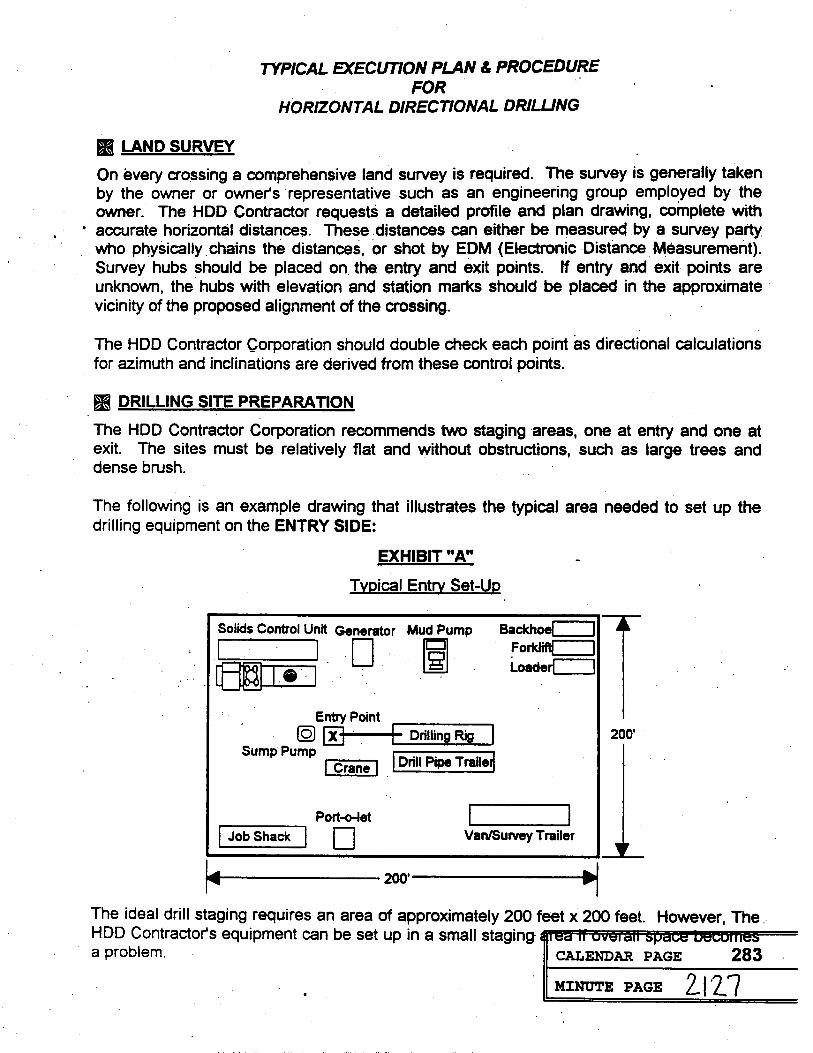
TYPICAL EXECUTION PLAN & PROCEDURE FOR
HORIZONTAL DIRECTIONAL DRILLING
LAND SURVEY
On every crossing a comprehensive land survey is required. The survey is generally taken by the owner or owner's representative such as an engineering group employed by the owner. The HDD Contractor requests a detailed profile and plan drawing, complete with
accurate horizontal distances. These distances can either be measured by a survey party who physically chains the distances, or shot by EDM (Electronic Distance Measurement). Survey hubs should be placed on the entry and exit points. If entry and exit points are unknown, the hubs with elevation and station marks should be placed in the approximate vicinity of the proposed alignment of the crossing.
The HDD Contractor Corporation should double check each point as directional calculations for azimuth and inclinations are derived from these control points.
DRILLING SITE PREPARATION
The HDD Contractor Corporation recommends two staging areas, one at entry and one at exit. The sites must be relatively flat and without obstructions, such as large trees and dense brush.
The following is an example drawing that illustrates the typical area needed to set up the drilling equipment on the ENTRY SIDE:
EXHIBIT "A"
Typical Entry Set-Up
Solids Control Unit Generator Mud Pump Backhoel
Forklift Loader
Entry Point
O X Drilling Rig 200
Sump Pump Drill Pipe TrailerCrane
Port-o-let
Job Shack Van/Survey Trailer
200
The ideal drill staging requires an area of approximately 200 feet x 200 feet. However, The HDD Contractor's equipment can be set up in a small staging area il overall space becomes a problem. CALENDAR PAGE
MINUTE PAGE 2127 283

Typical Execution Plan & Procedure Page 2
EXHIBIT "B" Typical Exit Set-Up
Total Crossing Distance-
Pipeline Laydown Area
Product Pipe Crane Exit
100'
Pipeline Rollers Sump Pit
Pull Back Direction 100
9 PIPELINE SITE PREPARATION
The pipeline staging area must be of sufficient length to accommodate the overall curve distance of the proposed crossing. It's width may vary according to the size pipeline that is being installed. Typically, The HDD Contractor would need approximately 50 feet to 75 feet to permit the pipeline equipment sufficient working space for hauling, stringing, welding and testing the continuous pipeline length that will be installed. If the space available to perform this work is limited, and one continuous pipeline length becomes impractical, then two or three smaller strings may be used. The pull back operation would stop while the pipeline lengths are aligned and welded. This is not recommended as it adversely increases the risk of the pipe becoming stuck.
DIRECTIONAL HEADING AND ALIGNMENT
Wire Line Steering Tool Survey
The directional heading (azimuth) must be taken on the proposed alignment of the crossing. All ferrous objects need to remain at a safe distance from the alignment area. The in-hole steering tool used for guidance has North referencing magnetometers that establish a magnetic heading. Ferrous objects interfere with the magnetometers and influence it's accuracy.
The steering tool is placed within a non-magnetic bottom hole assembly (BHA). This is a 30 foot section of drill pipe made up of a non-magnetic material such as stainless steel, monil, or aluminum. This "lead piece" of the BHA is placed on the alignment of the crossing from entry to exit. Once on this alignment, the steering probe is energized with electrical current and a bearing for the project is established and logged into the surface computer. (North is a 0 or 360 degrees, East is at 90 degrees, South is at 180 degrees and West is at 270 degrees on the face of a circle.)
CALENDAR PAGE 284
MINUTE PAGE 2128

Typical Execution Plan & Procedure Page 3
True Tracker Survey System
While the wire line steering tool has been a tried and true method of surveying for Horizontal Directional Drilling in the past, more and more projects are being designed in pipeline corridors that have many existing lines. The north referencing steering tool is influenced and becomes less accurate when ferrous objects such as these pipelines are encountered . while drilling. Another inherent problem with accuracy occurs on longer projects where the potential of a slight bearing differential in tenths, causes and overall error that may and up to many feet over the entire length of the crossing. Therefore; a survey. guidance system is now used to actually track the drilling head on each side of the river.
This tracking system is generally set up on land in a grid or coil fashion (see Exhibit "C"). The tracking grid or coil is configured by the using the depth of the proposed trajectory of the drilled path. Ordinarily, the grid or coil is set-up at the same width as the proposed depth of the drilled path on the land surface. The Tru Tracker has an accuracy of +/- 2% according to the manufactures accuracy standards. The length of the coil may be as long as 1,000' feet, and generally depends on the distance to the water. Once the tracking coils have been established and set, elevations are taken on each of the corners. Up to 32 comers can be used for these coils, however, it is the manufactures recommendation they be kept to a minimum. Having set the tracking coils, a magnetic field is created from current flow through the coil. The down hole probe senses this current and triangulates the location of the drill head by using this known geometry. For the precise accuracy of the of most all projects undertaken today, a combination of these modes is used. On the land segment the Tru Tracker will be used, once the drill path reaches the ocean, the North referencing steering mode will be used.
EXHIBIT "C" Typical Survey Layout
REE
TREES TREES
DRILL STAGING AREA TREES TO TREES ENTRY EXIT
TRU-TRACKER COL River TRU-TRACKER COIL PIPE STAGING AREA
TREES TREESTREES
THE PILOT HOLE
Once the heading has been established on the proposed crossing alignment the drilling rig is set precisely on line with a transit. The non-magnetic BHA's zad piece, that contains log
MINUTE PAGE 2129

Typical Execution Plan & Procedure Page 4
steering probe inside, and the directional tool that creates in-hole deviations are drilled in at exactly the designated entry point. Two additional non-magnetic drill pipe are added and drilled in behind the non-magnetic "lead piece" of the BHA. These additional pipes make up the non-magnetic BHA and serve as a buffer between the steering probe in the "lead piece" and the steel drill pipe that would create interference.
EXHIBIT "D" Standard Non Magnetic Bottom Hole Assembly
(3) 30' STAINLESS STEEL DRILL COLLARS STANDARD 6.675" - 90' FeetDRILL PIPE
APPROX. PROBE LOCATION STAINLESS STEEL CAMERA SUB
4.5" IN-HOLE MUD MOTOR
TAIL STABILIZER ADJUSTABLE HOUSING BIT JET BIT
- NOSE STABILIZERROTOR AND STATOR LOCATION PAD
The pilot hole is advanced linearly along a pre-determined profile. Directional deviation in azimuth and inclination are made accordingly to stay on the pre-determined inarcuate pathway.
Survey's are taken at 15 and 30 foot stations throughout the pilot hole. These are calculated and plotted on a work profile and plan drawing. This allows the survey technician to track vertical depth, horizontal distance and right/left bearing drift at all times during the project. Survey inclination and bearing numbers are given every eight seconds during the course of drilling one 30 foot section of drill pipe.
The HDD Contractor Corporation uses two methods to penetrate formations:
1. SPUD JET
This method uses hydraulics to erode the formation away for penetration of softer formations like sands, silts and clays.
11. IN-HOLE MUD MOTOR
This method uses a motor based on the Moineau principle and represents a highly efficient hydraulic, positive displacement motor. It converts hydraulic horsepower from the drilling fluid (volume and pressure) into mechanical horsepower (torque and rpm), which derives the drill bit only and allows hole deviation to occur when used in conjunction with a bent housing. This method is used to drill harder rock formations such as sandstone, shale, limestone and granite.
CALENDAR PAGE
MINUTE PAGE 2130 286

Typical Execution Plan & Procedure Page 5
PRE-REAM AND PIPE INSTALLATION
After the pilot hole is exited on line and is accepted, the non-magnetic BHA is taken off. A reaming device slightly larger than the outside diameter (O.D.) of the pipe is then attached. Typically, the reamer is sized approximately 35% to 50% larger than the O.D. of the pipe. The reamer is then rotated and pulled forward toward the exit side. Bentonite is injected through the drill pipe to the reamer. This aids in the penetration rate of the reamer but, more importantly, it suspends the cuttings and keeps the hole filled. . The slurry weight of the bentonite and drilled solids can reach mud densities up to 12 lbs. per gallon in a pre-reamed hole.
EXHIBIT "E" Typical Forward Reamer
Role Opener - WEWE
Work String
Lead String
Hole Opener Body
WEWE
A lead string will be used on the-forward-ream. It is simply the addition of the drill string at the entry side while the hole is being reamed. As each piece of drill pipe is taken off at the exit side, a joint of drill pipe will be added on the entry side. This insures the hole will have drill pipe in it continually, and reduce the possibility of losing the bore hole. The amount of fluid used during the pre-reaming is directly related to the time it takes to open up the desired diameter hole.
EXHIBIT "F" Typical Swivel Assembly
Universal Joint Swivel Body Connection
5" Drill Pipe
Drill Mud Spray
WEAVE TIT Hole
Once the reamer has reached the exit side and has been taken off, a pulling apparatus will be attached to the trailing string on the exit side. A jet swivel will be attached to the product pipe so the pilot work string is able to rotate. An exit angle of approximately eight to feg
CALENDAR PAGE
MINUTE PAGE 2131

Typical Execution Plan & Procedure Page 6
degrees will have been established allowing the product pipe to gently free stress into the open hole on exit side.
A large crane equipped with specialized cradles will assist the pipe to free stress into the hole by lifting the pipe approximately 50 to 100 feet from the leading end. Additional side boom tractors will be used in between the first roller and the stationary break over crane. The product pipe will be placed on pipe rollers prior to the pull back. Once the breakover crane and lead side boom tractors have been positioned correctly, the pull back operation will begin.
As the pipe is being pulled into the open hole, drilling fluid is pumped through the rotating jet swivel. This aids in the further suspension of the drilled solids that may be in the hole. These solids are removed by the velocity of the fluid coming out when the pipe displaces the drilling fluids in the open hole.
After the pipe reaches the entry side, the jet swivel will be taken off, the pipe will be capped, and a post test will be conducted to insure the pipeline's integrity.
CALENDAR PAGE
MINUTE PAGE 2132
288

289
2133
HDD DESIGN CRITERIA Set Up Area Product Pipe Laydown Area Radius of Curvature Cover Depth. . . Product Pipe Design & Coating Selection
CALENDAR PAGEMINUTE PAGEGeotechnical Considerations
Design Radius Design Radius Pipeline Laydown Drilling Rig Area
RIVER Exit Target AreaEntry Point Core BoreCore Bond
Core BoreCore Bors -.
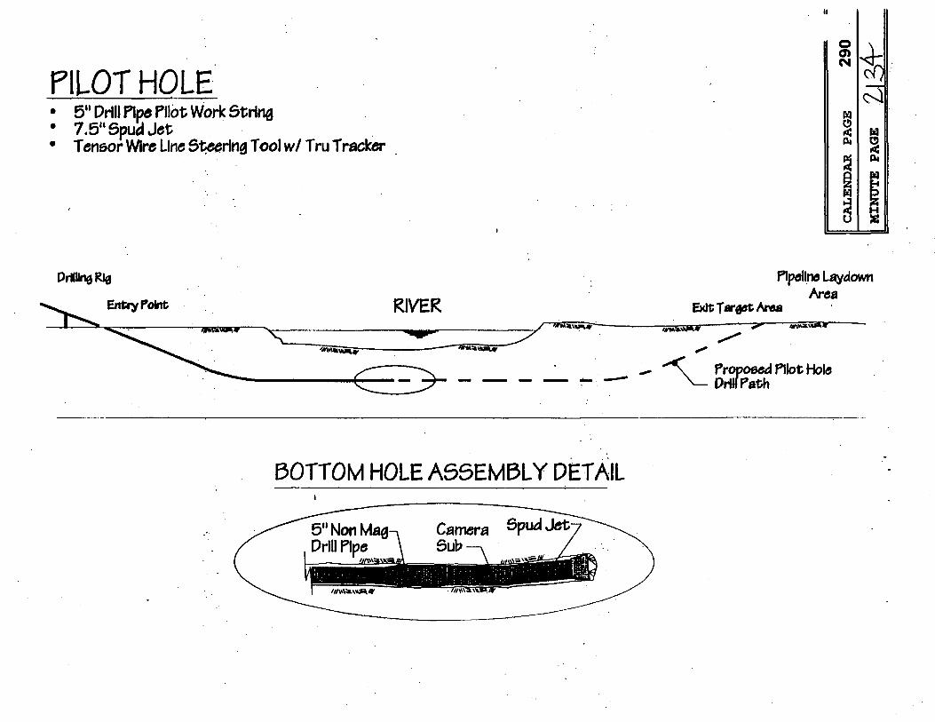
290
PILOT HOLE 2134 5" Drill Pipe Pilot Work String
. 7.5" Spud Jet Tensor Wire Line Steering Tool w/ Tru Tracker
CALENDAR PAGEMINUTE PAGE
Drilling Rig Pipeline Laydown Area
Entry Point RIVER Exit Target Area
Proposed Pilot Hole Drill Path
BOTTOM HOLE ASSEMBLY DETAIL
5" Non Mag- Camera Spud Jet-Drill Pipe Sub

291
FORWARD PRE REAM (Optional) 2135
24" Forward Hole Opener / Fly Reamer . 5" Drill Pipe . Drilling Mud Slurry . 5" Lead String
Auxiliary CALENDAR PAGEMINUTE PAGE Drilling Rig
RIVER Pulling Apparatus
Entry Point
Forward Hole Opener/-Fly Reamer 5" Lead String
Forward Reamed Open Hole- Drill Mud SlurryPilot Work String-
FORWARD PRE REAMING DETAIL
Forward Hole Opener/Fly Reamer
Drill Mud Slurry - 5" Lead String
To Exit
5" Drill Pipe -

292
2136
PRE REAM . 24" Hole Opener / Fly Cutter . 5" Tralling String
5" Drill Pipe MINUTE PAGECALENDAR PAGEPipeline Laydown
Drilling Rig AreaRIVER Exit Target AreaEntry Point
-Pre Reamed Hole Pilot Work String- -Hole Opener/Fly Reamer Drill Mud Slurry
5" Trall String
PRE REAM DETAIL
Hole Opener/Fly Reamer
Drill Mud Slurry<5" Drill Pipe - 5" Trall String

293
PRODUCT PIPE PULLBACK 2137 External Flush Swivel Assembly
. 5" Drill Pipe . Drilling Mud Slurry
MINUTE PAGECALENDAR PAGEPipeline LaydownEDrilling Rig ArdaRIVER
Entry Point
. . Swivel Assembly- Product PipePilot Work String -
-Drill Mud Slurry
PULL BACK DETAIL
Swivel Assembly 7 Product Pipe 75" Drill String 7 Rotation Swivel
Fluld Jets Non RotationalDrill Mud Slurry Universal Joint-
. . .'
ATTACHMENT 3
AGENCY CONSULTATION DOCUMENTATION
CALENDAR PAGE
MINUTE PAGE 2138
294

DEPARTMENT OF THE ARMY SAN FRANCISCO DISTRICT, CORPS OF ENGINEERS
211 MAIN STREET
SAN FRANCISCO, CALIFORNIA 94105-1905DEPART
JUN 0 6 1995 REPLY TO ATTENTION OF:
Regulatory Branch
Subject: File Number 21599$76
Mr. D. R. Ashurst, Project Engineer Western Business Unit Chevron Pipeline Company 5080 California Avenue, Suite 400 Bakersfield, California 93309-1671
Dear Mr. Ashurst:
This is in reference to your submittal of April 28, 1995,concerning 'Department of the Army authorization to performconstruction activities to replace portions of a product pipelinebetween the Tosco Refinery and the Vine Hill station, in the City of Martinez, Contra Costa County, California.
Your project qualifies under a Department of the Army Nationwide Permit, 33 CFR 330, Appendix A (B) (12) Utility Line Backfill and Bedding, pursuant to Section 404 of the Clean WaterAct (33 U.S.C 1344) .
This authorization will not be effective until Section 401 water quality certification or a waiver of certification has been obtained from the San Francisco Bay Regional Water QualityControl Board.
To ensure compliance with the nationwide permit, the following special conditions shall be implemented:
This authorization will remain valid until January 22, 1997,at which time all nationwide permits are scheduled to be modified, reissued, or revoked. If you commence or are under contract to commence work before the date the nationwide permit is modified or revoked, you will have twelve months from the dateof the modification or revocation to complete the project under the present conditions of this nationwide permit.
The project must be in compliance with the General Conditions cited in Enclosure 1 and all Special Conditions that may be specified above for the nationwide permit to remain valid. Non-compliance with any condition could cancel the nationwide permit authorization for your project, thereby requiring you to obtain an individual permit from the Corps. The nationwide permit authorization does not obviate the need to obtain other State or local approvals required by law.
CALENDAR PAGE 295
MINUTE PAGE 2139

-2-
You may refer all questions to Mark D'Avignon of our Regulatory Branch at 415-744-3324 Ext. 236. All correspondence should be addressed to the District Engineer, Attention: Regulatory Branch, referencing file number 21599576.
. Sincerely,
Calvin C. Fong Chief, Regulatory Branch
Enclosure
Copy furnished:
US F&WS, Sacramento, CA US EPA, San Francisco, CA US NMFS, Santa Rosa, CA CA RWQCB, Santa Rosa, CA CA F&G, Redding, CA
CALENDAR PAGE
MINUTE PAGE 2140 296

NATIONWIDE PERMIT CONDITIONS 33 CFR Part 330 EFFECTIVE DATE: January 21, 1992
GENERAL CONDITIONS:
The following general conditions must be followed in order for any authoriza tion by a nationwide permit to be valid:
1. Navigation. No activity may cause more than a minimal adverse effect on navigation.
2. Proper maintenance. Any structure or fill authorized shall be
properly maintained, including mainte-nance to ensure public safety
3. Erosion and siltation controls. Appropriate erosion and siltation controls must be used and maintained in effective operating condition during construction, and all exposed soil and other fills must be permanently stabilized at the earliest practicable date.
4. Aquatic life movements. No activity may substantially disrupt the
movement of those species of aquatic life indigenous to the waterbody, including those species which normally migrate through the area, unless the activity's primary purpose is to impound water.
5. Equipment. Heavy equipment working in wetlands must be placed on mats or other measures must be taken to minimize soil disturbance.
. Regional and case by-case conditions. The activity must comply with any regional conditions which may have been added by the division engineer (see 33 CFR 330.4(c)) and any case
specific conditions added by the Corps.-7. Wild and Scenic Rivers: No
activity may occur in a component of the .National Wild and Scenic River System:" or in a river officially designated by Congress as a "study river" for possible inclusion in the system, while the river is in an official study status. Information on Wild and Scenic Rivers may be obtained from the National Park Service and the U.S. Forest Service.
8. Tribal rights. No activity or its operation may impair reserved tribal rights, including, but not limited to, reserved water rights and treaty fishing and hunting rights.
9. Water quality certification. In certain states, an individual state water quality certification must be obtained or waived (see 33 CFR 330.4(c)).
10. Coastal zone management. In certain states, an individual state coastal zone management consistency concur-rence must be obtained or waived. (see Section 330.4(d)).
11. Endangered Species. No
activity is authorized under any NWP which is likely to jeopardize the comin-ued existence of a threatened or endan-gered species or a species proposed for such designation, as identified under the Federal Endangered Species Act, or which is likely to destroy or adversely modify the critical habitat of such species. Non-federal permittees shall notify the district engineer if any listed species or critical habitat might be affected or is in the vicinity of the project and shall not begin work on the activity until notified by the district engineer that the requirements of the Endangered Species Act have been satisfied and that the activity is authorized. Information on the location of threatened and endan-gered species and their critical habitat can be obtained from the U.S. Fish and Wildlife Service and National Marine S Fisheries Service. (sec 33 CFR 330.4(()
12. Historic properties. No activity which may affect Historic properties listed, or eligible for listing, in the National Register of Historic Places is authorized, until the DE has complied with the provisions of 33 CFR 325 Appendix C. The prospective permittee must notify the district engineer if the authorized activity may affect any historic properties listed, determined to be eligible, or which the prospective permittee has reason to believe may be eligible for listing on the National Register of Historic Places, and shall not begin the activity until notified by the District Engineer that the requirements of
the National Historic Preservation Act have been satisfied and that the activity is authorized. Information on the location and existence of historic resources can be obtained from the State Historic Preservation Office and the National Register of Historic Places (see 33 CFR
330.4(2)). 3. Notification. (a) Where
required by the terms of the NWP, the prospective permitted must notify the District Engineer as early as possible and shall not begin the activity:
(1) Until notified by the District Engineer that the activity may proceed under the NWP with any special conditions imposed by the district or division engineer, or
2) If notified by the District or Division engineer that an individual permit is required; or
3) Unless 30 days have passed from the District Engineer's receipt of the notification and the prospective permitlee has not received notice from the District
or Division Engineer. Subsequently, the permitlee's right to proceed under the NWP may be modified, suspended. or revoked only in accordance with the procedure set forth in 33 CFR 330.5(d)(2)
(b) The notification must be in writing and include the following information and any required fees:
(1) Name, address and telephone number of the prospective permitice;
(2) Location of the proposed project; 3) Brief description of the proposed
project; the project's purpose; direct and indirect adverse environmental effects the project would cause; any other NWP(s), regional general permit(s) or individual permit(s) used or intended to be used to authorize any part of the proposed project or any related activity.
(4) Where required by the terms of the NWP, a delineation of affected special aquatic sites, including wetlands.
5) A statement that the prospective permittoe has contacted;
i) The USFWS/NMFS regarding the presence of any Federally listed (or proposed for listing) endangered or threatened species or critical habitat in the permit area that may be affected by the proposed project; and any available information provided by those agencies. (The prospective permitted may contact Corps District Offices for USFWS/ NMFS agency contacts and lists of-critical habitat.)
ii) The SHPO regarding the presence of any historic properties in the permit area that may be affected by the proposed project; and the available information, if any, provided by that agency.
(c) The standard individual permit
application form (Form ENG 4345) may by used as the notification but must clearly indicate that it is a PDN and must include all of the information required in b)1)-(5) above.
(d) In reviewing an activity under the notification procedure, the District Engineer will first determine whether the activity will result in more than minimal individual or cumulative adverse environmental effects or will be contrary to the public interest. The prospective permitted may, at his option, submit a proposed mitigation plan with the
CALENDAR ANGLO expedite2197process and the District Engi
MIN Tiny opcorys mitigation the : 21441applica of her included in the proposal in determining whether the net adverse environmental effects of the proposed

activities that involve the discharge ofwork are minimal. The District the net adverse effects of the project dredged or fill material and must beEngineer will consider any comments (with the mitigation proposal) are followed in order for authorization by thefrom Federal and State agencies determined by the District Engineer to be nationwide permits to be valid:concerning the proposed activity's minimal. the District Engineer will
1. Water supply intakes. Nocompliance with the terms and conditions provide a timely written response to the discharge of dredged or fill material mayof the nationwide permits and the need applicant informing him that the project
for mitigation to reduce the project's can proceed under the terms and occur in the proximity of a public water conditions of the nationwide permit. supply intake except where the dischargeadverse environmental effects to a
is for repair of the public water supplyminimal level. The district engineer will e) Wetlands Delincations: Wetland intake structures or adjacent bankupon receipt of a notification provide delineations must be prepared in stabilization.Immediately (c.g. facsimile transmission, accordance with the Federal Manual for
2. Shellfish production. Noovernight mail or other expeditious Identifying and Delincating Jurisdictional Wetlands or the current method required discharge of dredged or fill material maymanner) a copy to the appropriate offices
occur in areas of concentrated shellfishof the Fish and Wildlife Service, State by the Corps. The permitted may ask the natural resource or water quality agency, Corps to delineate the special aquatic production, unless the discharge is
directly related to a shellfish harvestingEPA, and, if appropriate, the National site. There may be some delay if the Marine Fisheries Service. With the Corps does the delincation. Further- activity authorized by nationwide exception of NWP 37, these agencies more, the 30-day period will not start permit 4. will then have 5 calendar days from the until the wetland delinestion has been 3. Suitable material. No discharge dare the material is transmitted to completed. of dredged or fill material may consist of telephone the District Engineer if they (f) Mitigation: Factors that the unsuitable material (c.g., trash, debris.
intend to provide substantive, site- District Engineer will consider when car bodies, etc.) and material discharged specific comments. If so contacted by an determining the acceptability of appropri- must be free from toxic pollutants in agency, the District Engineer will wait ate and practicable mitigation include, toxic amounts (see section 307 of the an additional 10 calendar days before but are not limited to: Clean Water Act). making a decision on the notification. (1) To be practicable the mitigation 4. Mitigation. Discharges of The District Engineer will fully consider must be available and capable of being dredgod or fill material into waters of the
agency comments received within the done considering costs, existing United States must be minimized or
specified time frame, but will provide no technology, and logistics in light of avoided to the maximum extent practi-response to the resource agency. The overall project purposes; cable at the project site (i.c. on-site), District Engineer will indicate in the (2) To the extent appropriate, unless the DE has approved a compensa-administrative record associated with permittees should consider mitigation tion mitigation plan for the specific each notification that the resource banking and other forms of mitigation regulated activity. agencies' concerns were considered. including contributions to wetland trust i. Spawning areas. Discharges in Applicants are encouraged to provide the funds, which contribute to the restors- spawning areas during spawning seasons Corps multiple copies of notifications to tion, creation, replacement, enhance- must be avoided to the maximum extent
expedite agency notification. If the ment, or preservation of wetlands. practicable. District Engineer determines that the Furthermore, examples of mitigation 6. Obstruction of high flows. To activity complies with the terms and that may be appropriate and practicable the maximum extent practicable, conditions of the NWP and that the include but are not limited to: reducing discharges must not permanently restrict adverse effects are minimal, he will the size of the project; establishing buffer or impede the passage of normal or notify the permittee and include any zones to protect aquatic resource values; expected high flows or cause the conditions he deems necessary.' If the and replacing the loss of aquatic resource relocation of the water (unless the District Engineer determines that the values by creating, restoring, and primary purpose of the fill is to impound adverse effects of the proposed work are enhancing similar functions and values. waters).
more than minimal, then he will notif In addition, mitigation must address 7. Adverse impacts from impound-the applicant either. (1) that the project impacts and cannot be used to offset the ments. If the discharge creates an does not qualify for authorization under acreage of wetland losses that would impoundment of water, adverse impacts the NWP and instruct the applicant on occur in order to meet the acreage limits on the aquatic system caused by the the procedures to seek authorization of some of the nationwide permits (c.g. s accelerated passage of water and/or the under an individual permit; or (2) that acres of wetlands cannot be created to restriction of its flow shall be minimized the project is authorized under the change a 6 acre loss of wetlands to a 1 to the maximum extent practicable nationwide permit subject to the were loss; however, the 5 created acres 8. Waterfowl breeding areas. applicant's submitting a mitigation can be used to reduce the impacts of the Discharges into brooding areas for proposal that would reduce the adverse 6 acre loss). migratory waterfowl must be avoided toeffects to the minimal level. This the maximum extent practicable. mitigation proposal must be approved by 9. Removal of temporary fills.
the District Engineer prior to commence SECTION 404 ONLY Any temporary fills must be removed inng work. If the prospective permittee their entirety and the affected areasCONDITIONS:clocks to submit a mitigation plan, the DE sturned to their proexisting clevationwill expeditiously review the proposed
In addition to the General Conditions,mitigation plan, but will not commence s CALENDAR PAGEthe following conditions apply only tosecond 30-day notification procedure. If
MINUTE PAGE 2142 298

PETE WILSON. GOVE TEL. (510) 286-1255
CALIFORNIA REGIONAL WATER QUALITY CONTROL BOARD FAX: (510) 286-1380
SAN FRANCISCO BAY REGION 885: (510) 286-G404 2101 WEBSTER STREET. SUITE 500
STATE OF CAL FORNIA
JUL 2 4 1995OAKLAND, CA 94612 Date:
File No.: 2118.03(MYM)
Lt. Col. Michael Walsh District Engineer U. S. Army Corps of Engineers 211 Main Street San Francisco, CA 94105-1905
Attn: Ms. Liz Varnhagen
SUBJECT: WATER QUALITY CERTIFICATION WAIVER (Corps File No. 2159976) - Pipeline Installation Project, Martinez, Contra Costa County
Dear Lt. Colonel Walsh:
We have reviewed the proposal from Mr. Doug Ashurst, on behalf of Chevron Pipeline Company with regard to the subject project. Specifically, Chevron proposes to replace portions of a product pipeline between the Tosco Refinery and the Vine Hill station, in the City of Martinez, Contra Costa County.
Your staff has determined that the proposed project qualifies for authorization under a Department of the Army nationwide permit {33 CFR 930 Appendix A, B, (12), utility line backfill and bedding, pursuant to Section 404 of the Clean Water Act (83 U.S.C. 1844).
The project sponsors have applied for a Clean Water Act Section 401 water quality certification that the proposed project will not violate State water quality standards. Pursuant to Regional Board Resolution No. 87-053, Waste Discharge Requirements are waived as required by 33 CFR 325.2(b) (ii) provided the discharge of fill to waters of the United States is minimized.
We anticipate no further action on this application. However, should new information come to our attention that indicates a water quality problem with this project, the Regional Board may issue Waste Discharge Requirements.
Sincerely,
STEVEN R. RITCHIE Executive Officer
cc: Nadell Gayou, DWR Oscar Balaguer, SWRCB
Mr. D.R. Ashurst, Project Manager Western Business Unit Chevron Pipeline Company 5080 California Ave., Suite 400 Bakersfield, CA 93309-1671
CALENDAR PAGE 299
MINUTE PAGE 2143

ATTACHMENT 4
AIR QUALITY ASSUMPTIONS/CALCULATION DATA SHEETS
CALENDAR PAGE 300
MINUTE PAGE 2144

ATTACHMENT (4): AIR QUALITY SUPPORT DATA
Estimation of Fugitive Particulate Matter Emissions Associated with Construction-related Soil Disturbance
(1) - Assumptions: 2.0Average Daily Acres of Construction: ..
(2) - Emission Factor* Emission Factor (Unmitigated) 1.2 Tons/Acre/Month
Emission Factor (Mitigated) 0.6 Tons/Acre/Month
Emission Factor (Unmitigated) 109.1 Pounds/Acre/Day
Emission Factor (Mitigated) 54.5 Pounds/Acre/Day
(3) - Total Daily Emissions Emissions (Unmitigated) 218.2 Pounds/Day
Emissions (Mitigated) 109.1 Pounds/Day
. .
*= Emission factors based on Bay Area Air Quality Management District's Air Quality and Urban Development: Guidelines for Assessing Impacts of Projects and Plans (November (285)
MINUTE PAGE 2145 30

ATTACHMENT (4) AIR QUALITY ANALYSIS SUPPORT DATA (continued)
Total Construction Operations Emissions Summary
Source Pollutant Type
CO ROC NO, SO, PM10
1) Construction-related Soil Disturbance Emissions N/A N/A N/A N/A 109.1*
2) Construction equipment Exhaust Emissions 59.5 8.5 135.8 16.2 10.9
3) Total Emissions 59.5 8.5 135.8 16.2 120.0
BAAQMD's Significant Thresholds 550 150 150 150 150
5 ) Significant Impact NO NO NO NO NO
* = Based on emissions after implementation of the appropriate mitigation mabHUDAR PAGE
MINUTE PAGE 2146 302

ATTACHMENT (4): AIR QUALITY ANALYSIS SUPPORT DATA (continued)
Estimation of Criteria Pollutant Emissions Associated with the Construction Equipment & Exhaust
(1) Equipment Type
(2) Hours of Operation
(3) Emission Factors* CO
ROC NOx SOx
PM10
(4) Emissions CO
ROC
NOx SOxCALENDAR PAGE
PM10
Trucks
893
1.80
0,19
4.17 0.45
0.26
1607.40
169.67
3723.81
401.85 232.18
(5) Total Construction Exhaust Emissions CO
ROC
NOx SOx PM10Lb17 zovd aLANIN
Dozer
360
N/A N/A
N/A
0.35
0.17
N/A
N/A N/A
126.00
59.40
Tractor Miscellaneous
40
3.58 0.18 1.27
0.09
0.14
143.20
7.20
50.80
3.60
5.60
1374
0.68
0.15
1.70
0.14
0.14
927.45
206.10
2335.80
196.48
192.36
Total Emissions for Duration 2678.05
382.97
6110.41
727.932 489.54
. Um ssion factors based on EPA's AP-42 document, Volume 2 (4th Ed.).
= Daily emissions are based on a 9-week construction period (45 days).
Daily Emissions* * 59.51
8:51
135.79
16.18 10.88

ATTACHMENT 5
ACM REMOVAL AND HANDLING PROCEDURES FLOWCHART
CALENDAR PAGE
MINUTE PAGE 2148
304

5.5.10 PROCEDURES FOR SMALL SCALE MANUAL REMOVAL AND DISPOSAL OF PIPE AND COATING MATERIALS THAT CONTAIN ASBESTOS
(ACM = Asbestos Containing Material)
Complete AQMD/APCD notification form and retain in file. Do Not submit to
APCD/AQMD
CPL employees can perform ACM job if objective data from previous removal jobs are below acceptable exposure
levels
DO NOT USE POWER TOOLS!! all work to be done with hand tools,
chisels, etc.
Establish work areas with caution tape prior to any disturbacne or removal of
ACM.
All workers to wear safety glasses with side shields or goggles in work area.
Respiratory protection; half mask air-purifying negative pressure respirator with HEPA filters is optional based on air monitoring results below the action level and/or excursion level on other
similar work conditions
Once in work area workers are not to leave wearing contaminated clothing. Clothing to be removed in a change area or cleaned using HEPA filtered vacuum prior to leaving work area.
Trench surface, including floor & sides, are lined with 6 mil. polyethylene to
collect and contain ACM
ACM must be kept wet (with water) at all times during removal operation. As
one worker removes or cuts ACM. another worker sprays a fine mist of
water on the ACM. (wetting agents can be purchased)
CALENDAR PAGE
MINUTE PAGE 2149Continued on page 2
305

After removing ACM, clean pipe surface thoroughly and wet wipe to
remove all traces of ACM.
Prior to removing any equipment, used for ACM removal from work area,
decontaminate by wet wiping.
Place disposable protective clothing and rags used to clean equipment, and
trench lining in doubled 6 mil. polyethylene bags and dispose of as
non-hazardous ACM waste.
All disposal bags must be labeled with the following language:
DANGER
CONTAINS ASBESTOS FIBERS AVOID CREATING DUST
CANCER AND LUNG DISEASE HAZARD
Place ACM waste in DOT approved container.
Label container with completed non-hazardous waste sticker.
Prepare ACM waste Bill of Lading. Send w/load, retain copy.
Transport container and piping w/ attached ACM coating or wrap to a Chevron approved ACM disposal
facility
Retain all waste records.
CALENDAR PAGE Stop
MINUTE PAGE 2150
Page 2 of 2
306

ATTACHMENT 6
LAND OWNER COORDINATION REPORT
CALENDAR PAGE 307
MINUTE PAGE 2151

TRPP Landowner Coordination Report
The following record of discussions was prepared by Don Shelhart on behalf of Chevron and updated on August 10, 1995. The following is the current status of property owner contacts for theAvon to Vinchill pipeline project
APN 161-240-13 (parking lot) Sites: 4030 Pacheco Blud, Martinez Owner. Caroline R. Blair
2050 Franklin Canyon Road Martinez, CA 94553 Bus: 229-3572, pager 295-8241
On 7\21\95 I talked to Caroline Blair who referred me to her husband. On 8\2195 1 talked to Butch Blair, owner of Butch's Excavating. Said not to contaminate the gravel with dirt, to" load the spoils into a truck and if more gravel is needed, to use 3/4"ab gravel from Syar so it will match. Said that it is okay to move the beams to the left of the Shell gate, if they are replaced as they were found
Tenant: Reliable Liquid Transport, Inc: On 7\13195 I met with Richard Fuller (229-9180), president. Said they rent most of the parking lot and need access 24 hours a day seven day a week because of the nature of their business. Said he will loose several parking spots because of the construction but did not ask for compensation.
2. APN 161-240-10 Situs: 4040 and 4036 Pacheco Blvd, Martinez Owner. Arthur W. and Janice A Foster
412 Ponderosa Ct Lafayette, CA 94549 Res: 932-7634 Bus: 228-3380
On 7\13\95 I met with Art Foster who owns both buildings on this property and the business (Martinez Sheet Metal) in the south building. Mr. Foster remembers the relocation in 1982 and said that he is going to be more particular this time. Said he was not happy with the subsequent settlement and patch job to the pavement. He said in '82 there was an early rain and there was allot of mud. He said doing the work on the weekend, the way we did it before, will be good. Said the property is locked on the weekends and we will need to pick up a key from either him or his son, Glen. Said he wants 3-4 days notice and not to come by on a Friday and start work the next day.
Tenant: Mother's Cookies: On 7\18195 I talked to Berry Nelson (8001767-0537), District Manager. Said no problem to give him a call if we need anything moved in the parking area.
Tenant: Emminger Corp: On 7\13\95 1 met with Bill Clark (313-5830), General Manager. Said he needs to be notified when construction will begin because many times they make deliveries on the weekends.
CALENDAR PAGE
MINUTE PAGE 2152 308

3. APN 161-250-10 Owner: AT&SF Railway Company
920 S.E. Quincy Street
Topeka, Kansas 66612-1116 On 717\95 I talked to Clark Ransdell (913\435-2228) in Topeka. Said that by using the
existing casing to replace the 10" BAPL at their MP 1167.4 (our station 1088+88), we do not need a new license because this is considered maintenance under our current license. The access road on the south side of the tracks which goes east from this location, is on the railroad property and is okay to use during construction. However, the new line on their property south of Pacheco Blud will require a new license (application mailed 7\21\95). .We also cross a spur track
to the west of the Walnut Creek Flood Control Channel which will require a license (application mailed 8\7\95). Their local field rep, Daryl Swallow at 209-441-2552, in Fresno, will need to be contacted before work begins at all three locations.
4. Pacheco Bivd Crossing On 818195 the county issued their Encroachment Permit #10234. Arrangement for
inspection must be made 48 hours before the begin of work. Call inspector Miner Ashcraft at 313-2320, or cellular 612-2802.
5. APN 380-042-02 Situs: 4507 Pacheco Blvd, Martinez Owner: Laidelaw Environmental Services Co.
4501 Pacheco Blud.
Martinez, CA 94553 On 7\13\95 I met with Joe Davi (372-4800 ext. 808), Facility Manager. The property is
being regraded and bermed starting in August. Initially it appeared their berm would cover. the lines, but after potholing, the berms only cross the lines in two locations. The lines are inside the fence in their parking area. Contact Vonda L. Derryberry (372-4816) Construction Manager, to coordinate entry. (It might be best to have them not pave the area of their parking lot where we will be working.)
6. APN 380-042-03 Situs: 4575 Pacheco Blvd, Martinez Owner: Lippow Development Co.
838 Escobar
Martinez, CA 94553 Bus: 757-7882
On 7\19195 I talked to Mr. Lippow. He is in the process of leasing his building and will notify his new tenant
CALENDAR PAGE
MINUTE PAGE 2153 309

7. APN 380-042-09 Situs: 4579 Pacheco Bivd, Martinez
Owner: Siro and Anne V. Sabatini 4530 Grothman Ln Martinez, CA 94553
On 7\21\95 I talked to Mr. Sabatini (228-1162). He said he sees no problem as long as the pavement in the parking area is repaired and we work with his tenant. He remembered when we came through in 1982 and said we did a good job.
. . . Tenant: Al Adjustments Company: On 7\13\95 I met with Kathy (229-5800) who said they are a vehicle repro company which needs access through the gate to the rear 24 hours a day.
8. APN 380-26-01 Situs: 4585 Pacheco Bivd, Martinez Owner: Pacheco Properties
605 Minor Road Orinda, CA 94563
On 7\26195 I talked to Mr. Ray Bickerstaff (254-4694 or 254-8786), the owner. He has no problems with our work as long as his tenants are taken care of. Said in restoring the landscaping in front of 4585 Pacheco Blud, if we needed a contractor we could call Dave Burnly with Contra Costa Landscaping at 229-1060. Was not concerned with the possible pine tree removal on 380-260-003, said it was probably a volunteer anyway.
Tenant: IT International Technology Corporation: On 7\13\95 I met with Russell D. Bricker (372-9100), Facilities and Technical Support Manager. Said he trusts Chevron to repair the damage to the landscaping and that he remembers in 1982 there was no trouble.
9. APN 380-260-002 Situs: 4595 Pacheco Blud
Owner: Pacheco Properties, see #7 Tenant: Independent Scissor Lifts, Inc: On 7\25195 I met with the warehouse manager
(229-1701), who's main concern was for the security of the property during construction (he also asked that a letter be sent the president, John Harrington). It appears that fencing will need to be removed by the road in the front and in the back on the south side of the property.
10. APN 380-260-003 (possible tree removal on this property) Situs: 4589 & 4591 Pacheco Blud Owner: Pacheco Properties, see #7 Tenant: Graybar Electric Company: On 7\25195 I met with Eugene Fassiotto (228-
5110). His concern was with the parking. He said on Wednesday September 25th, they will have their Annual Open House and they would appreciate it if we did not have construction vehicles and equipment in the parking area on that day.
Tenant: De Longhi: On 7\23195 I met with Dan Mosby (228-9960), the warehouse manager. He said he sees no problem and the gate will be open from 6 to 6 five days a week and from 9 to 12 on Saturday.
CALENDAR PAGE
MINUTE PAGE 2154 310

11 Caltrans, Highway 680 Crossing No new permit is require for our work under 680. The existing Consent to Common Use
Agreement with Caltrans only requires notification. Notification letter mailed on 812195.
12. APN 380-043-03 APN 380-030-08
Owner: ACME Fill Corp 950 Waterbird Way Martinez, CA 94553
On 7\19195 I meet with Michael Reed (228-0625), Director of Operations. No problem with our work or moving the block valves out of the wetland area. As long as we stay within the existing easement, it's okay to put a protective fence around the above ground valve in the new location (PG&E has also approved the new location for the valve which will be within their tower line easement)
13. Contra Costa Canal property Owner: Contra Costa Water District
2300 Stanwell Drive Concord, CA 94524
On 7\ 1\95 I talked with Tony Rocha (674-8076). Tony will review our casement grant and construction drawings before he gives the okay to go ahead. He said most likely another encroachment permit will not be necessary because we are at the same location as our permit #796400-3, which was issued on 717195.
14. APN 159-140-50 Owner. Central Contra Costa County Sanitary District
5019 Imhoff Place Martinez CA 94553-4392
On 7\ 1\95 I mailed our notification letter to Ken F. Laverty (229-7307). On 8\3\95 1 talked with Ken, he said the timing is okay but that their engineers want us to be aware of their underground facilities in the area. There is a 72" outfall pressure line, 42" reclaimed water pressure line, two 20" M-2 incoming sewer pressure lines, and numerous other smaller lines
some of which are plastic. These lines are at various depths and our lines run between some of them. Ken said the District will survey and stake out the approximate location of their lines to assist Chevron. A preconstruction meeting at the site can be arranged by calling Ken at the above number. Ken also said that there was a pressure landfill gas line in the road to the west of their lines (this could be where we cross AT&SF) and that Air Products should be contacted at 562-9248.
15. Solano Way Crossing (pavement 26', RIW 40') On 813195 the county issued their Encroachment Permit #10232. No cutting of pavement
and arrangement for inspection must be made 48 hours before the begin of work. Call inspector Miner Ashcraft at 313-2320, or cellular 612-2802.
CALENDAR PAGE 311
MINUTE PAGE 2155

16. SPRR
One Market Street
San Francisco, CA 94105 On 8\4\95 Joe Ivanucich (9161789-5165), an engineer in Roseville, said that because we
are using the existing casing, we are doing work under an existing agreement and to contact their local field rep, Don Thomas in Martinez, at 891-7466, or pager 308-1840.
LANDOWNER COORDINATION PLANS, CHEVRON'S RESPONSE TO ISSUES:
1. Owner: Chevron will comply with the requirements described by Mr. Blair. Tenant: Chevron will cooperate in scheduling to minimize the impacts to Reliable Liquid Transport. Some parking spots will be temporarily unusable during construction.
2. Owner: Chevron will cooperate with Mr. Foster's scheduling requirements i.e., perform the work on weekends. Settlement will be minimized by achieving 90% compaction of the backfill under the paved area. Settlement or other problems that appear after construction activities will be repaired by Chevron. Tenant: Chevron will cooperate in scheduling to minimize the impacts to Mother's Cookies.
Tenant: Chevron will cooperate in scheduling to minimize the impacts to Emminger Corp.
3. Owner Chevron will contact local field representative for AT&SF prior to beginning work. Anticipating new license for spur track crossing.
A Owner Encroachment permit received from Contra Costa County. Chevron will coordinate work with inspector, Mr. Ashcraft
5. Owner: Further meetings between Chevron and Laidelaw have resulted in agreement regarding the berm and construction conflicts. Chevron and Laidelaw will continue to cooperate to work out details.
6. Owner: No conflicts noted at this time.
7. Owner: Chevron will replace any damaged pavement as needed. Tenant: Chevron will cooperate in scheduling to minimize the impacts to Al Adjustments.
Owner: Chevron will replace any damaged landscaping and work with the tenants. Tenant: Chevron will replace any damaged landscaping at IT International Technology Corporation.
CALENDAR PAGE
MINUTE PAGE 2156
8
312

9. Owner: Same owner as No. 7. No other specific issues. Tenant: Chevron will cooperate to maintain security. Letter will be sent to Mr. Harrington.
.10. Owner: Same owner as No. 7. No other specific issues. Tenant: Chevron will cooperate in scheduling to minimize the impacts to Graybar. No construction will be scheduled in this area on Sept. 25.
Tenant: Chevron will cooperate in scheduling to minimize the impacts to De Longhi.
11. . Owner; Notification made to Cal Trans.
12. Owner. Chevron is working cooperatively with ACME. No other specific issues.
13. Owner: Chevron agrees that existing encroachment agreement should apply, but will obtain or ammend encroachment permit if required.
14. Owner: Chevron will work with Sanitary District to locate any sub-surface facilities. No other specific issues.
15. Owner: Chevron will comply with requirements from CCC encroachment permit.
16. Owner: Chevron agrees that existing license should apply. Chevron will coordinate work with local field representative, Mr. Thomas.
CALENDAR PAGE
MINUTE PAGE 2157 313

EXHIBIT "D" MONITORING PROGRAM
FOR THE CHEVRON AVON TO VINE HILL PIPELINE
Impact: The proposed project may have the possibility of an upset or petroleum product
spill, either from a puncture of an active pipeline or from construction equipment.
Project Modification: Chevron has prepared an Oil Spill Contingency Plan in compliance with the Oil
Pollution Act of 1990 (OPA). This plan includes notification procedures, response strategies, organization of response teams and the listing of available equipment.
Monitoring: Staff of the State Lands Commission, or its designated representative, will inspect the project during the construction period to determine that all equipment specified in the Oil Spill Contingency Plan is available on the site.
Impact: Increased erosion is possible during the actual construction period.
Project Modification:
The construction is authorized under Nationwide Permit No. 12, US Army Corps of Engineers, pursuant to Section 404 of the Clean Water Act. Under this permit, Chevron must conduct all construction activities in compliance with the General Conditions of the permit, including stabilization of exposed soils, use of appropriate erosion and siltation controls, and placement of equipment on mats in wetlands areas.
Monitoring: Staff of the State Lands Commission, or its designated representative, will be present during the crossing of Pacheco Slough to determine that all required erosion control procedures are in place.
Impact: Construction across Pacheco Slough could impact aquatic life if it is done when the Slough contains water.
Project Modification: In accordance with the Department of Fish and Game's Stream Bed Alteration Agreement with Chevron, the crossing of Pacheco Slough will take place prior to October 15th.
CALENDAR PAGE
MINUTE PAGE 2158 314

Monitoring: Chevron will notify the staff of the State Lands Commission at least 24 hours
prior to constructing the crossing of Pacheco Slough, so the it can be determined that tihis contruction window is observed.
Impact: Construction activities could increase air emissions of particulate matter.
Project Modification: Daily watering of construction sites will be required to reduce dust emissions.
Monitoring: Staff of the State Lands Commission, or its designated representative, will inspect the site to verify that this dust control measure is implemented.
Impact: Construction equipment could damage Pacheco Boulevard or Solano Way in the vicinity of the project.
Project Modification: Chevron will include "before and after" video documentation of the condition of Pacheco Boulevard and Solano Way in the vicinity of the project. If any significant change is evidenced by the videos, Chevron will enter into an agreement with the Contra Costa County Public Works Department to provide for the restoration of the roads to their pre-project conditions.
Monitoring: Staff of the Contra Costa Public Works Department will view the videos upon completion of the project.
Impact: The proposed project would effect traffic in the vicinity of Pacheco Boulevard and Solano Way during the construction phase.
Project Modification:
Chevron and it's contractor will finalize and get approval from the Contra Costa County Planning Department of a detailed traffic plan prior to the onset of construction at these locations.
Monitoring: The Contra Costa County Planning Department will approve the abaove plan prior to construction. Staff of the State Lands Commission, or its designated representatives, will confirm that the plan, as approved, is being followed during construction.
Impact: Due to the highly industrialized nature of the project corridor, the potential existsCALENDAR PAGE 315
MINUTE PAGE 2159

for contaminated soils to be encountered during excavation.
Project Modification: Spoils shall be monitored for the presence of Benzene, total hydrocarbons, heavy metals and volatile organic compounds. In the event contaminated soils are encountered, work will be stopped and Chevron's worker protection program will be implemented based on the level and type of contaminant discovered. Results of the monitoring program will be maintained at Chevron for one year, and may be forwarded to the Department of Toxic Substances Control if any contaminants are discovered.
Monitoring: Staff of the State Lands Commission, or its designated representatives, will randomly check at least two of the spoils analyses, and will ensure that proper protective equipment is available for the construction workers.
CALENDAR PAGE
MINUTE PAGE 2160
316


![ISO Standard [ISO 21287] Compact Cylinder · 2019. 10. 13. · 1 How to Order ø20, ø25, ø32, ø40, ø50, ø63 Series C55 ISO Standard [ISO 21287] Compact Cylinder C55 With auto](https://static.fdocuments.in/doc/165x107/60ca4145cfa75a6dce050d9f/iso-standard-iso-21287-compact-cylinder-2019-10-13-1-how-to-order-20-25.jpg)