
TITLE FOR BINDING - SPINE LATE QUATE~~ARY SEDIMENTARY...
110
TITLE FOR BINDING - SPINE LATE SEDIMENTARY ENVIRONMENTS, SEPT-ILES, P.Q.
Transcript of TITLE FOR BINDING - SPINE LATE QUATE~~ARY SEDIMENTARY...

TITLE FOR BINDING - SPINE
LATE QUATE~~ARY SEDIMENTARY ENVIRONMENTS, SEPT-ILES, P.Q.

LATE-QUATE~~ARY SEDDŒNTARY
ENVIRONME~~S, SEPT-ILES, QUEBEC
by
Lynda A. Dredge
ABSTRACT
The thesis presents the results of a geomorphological
investigation at Sept-Iles, Quebec. Six sedimentary environments
are identified, described, and arranged into a stratigraphie column:
till, outwash, offshore and nearshore deposits, fluvial accretions,
and peat. Landscape development is th en explained by incorporating
the environments into a late- and post-glacial framework. An uplift
curve generated from stratigraphie evidence and two radiocarbon dates
indicates that the final deglaciation, synchronous with the marine
limit at 128 m asl, occurred at about 9,300 years BP. Although no
breaks in the late-Quaternary sedimentary sequence have be(::i'1 detected,
the slope of the uplift curve suggests that a non-glacial phase ::-Uij·
ha~e occurred at about 12,500 BP.
:~.:)c. '!"hesis :x:?ar::::c:1: of Gcogra?h:; ~cGil1 [:1i~ersit~
~o:1=real 110. ?Q.

LES HILIEUX SEDU-Œ~'TAlRES DU TARDI-QUATERNAIRE
SEPT-ILES, QUEBEC
par
Lynda A. Dredge
RESUHE
Le mémoire de recherche présente certaines interprétations
géomorphologiques de la région des Sept-Iles au Québec. L'auteur
y reconnalt six milieux sédÜDentaires qui sont décrits et classifiés
en une séquence stratigraphique; ce sont le till, les dépôts de dé
lavage, les dépôts d'avant-côte, les formations littorales et para
littorales, les accumulations fluviatiles et la tourbe. Le façonne
ment et l'évolution morphologique du paysage s'expliquent ensuite en
insérant ces traits du milieu dans le cadre du post- et du tardi
Glaciaire. La stratigraphie et deux dates déterminées au radiocarbone
nous permettent de tracer une courbe du soulèvement isostatique.
Cette courbe indique que la fin de la déglaciation associée à la
limite marine sise maintenant à 128 m se produisit il y a environ
9300 ans. Enfin, même si l'auteur n'a pu déceler aucune interruption
à ~ra· .. ers la séquence s~dL"':lentaire du Quaternaire récent, la pente
de la courbe du soulè:vc::Jent isostatique nous per::let de penser qu'une
?hasc ~on glaciaire a pu survenir il a environ 12,500 ans.
LATE -QUATERNARY SEDIMENTARY
ENVIRONMENTS, SEPT-ILES, QUEBEC
Lynda A. Dredge
A thesis submitted to the Faculty of Graduate Studies
and Research in partial fulfilment of the requirements
for the degree of Master of Science
:)c?a:-:::-.c:;: 0: Gcol;rap:,:: ~cGill ~ni~crsit~
~onacal 110. :'.Q.
~: -_.# . . JO·
';-'Jl::, 1<:171
PREFACE
The thesis presents the results of a geomorphological
investigation conducted in the Sept-Iles area. It attempts to
describe and explain the characteristics of the present landscape
in terms of a sequence of sedtmentary environments produced during
the late Quaternary.
The information provides a model for deglaciation aiong
the central portion of the North Shore. Since many of the descrip
tions allude to conditions of slope failure, sources of construction
materials, drainage problems, and land-use potential, the geomorph
ological report may also assist those concerned with the proper
economic development of the region.
The writer wishes to express particular thanks to Dr. R.W.
Pryer and Mr. F. Guerre of the Quebec North Shore and Labrador Rail
way for their constant co-operation and for lending maps, borehole
records and photographs; to the Iron Ore Company of Canada for
financial assistance; and to the Geological Survey of Canada for
financial support and for the radiocarbon dating of shell and wood
sacples.
- i -

TABLE OF CONTENTS Page
PREFACE. . . . . . . . . . . . . . . . . . . . . . . . . . . . . . . • . . . . . . . . . . . . . . . . . . . . . i
TABLE OF CONTENTS........................................... i i
LIST OF FIGURES ............................................. iii
LIST OF PHOTOGRAPHS..... . . . . • . . . . . . . • . . . . . . . . . . . . . . . . . . . . . . . i v
SECTION
l INTRODUCTION
1.1 General Physiography.......... .....•.. ........ l 1.2 Bedrock Geology........... . . . . . . • . . . . . . . . . . . . . 6 1.3 Previous Work................................. 7 1.4 The Present S tudy. . . . . . • . • . . . . . . . . . . . . . . . . . . . . 7
II SEDIMENTARY ENVIRONMENTS
2.1 "Sedimentary Environments"................ .... 9 2.2 Till.......................................... 12 2.3 Glacial-fluvial Outwash....................... 17 2.4 Estuarine Sediments.................. . • . . . . . . . 22 2.5 Coas tal Depos i t9 . . . . . . . . . . . . . . . . . . . . . . . . . . . . . . 30 2.6 Fluvial Accretions... ...........•..•.......... 39 2. 7 Organic Accumulations. . . . . . . . . . . . . . . . . . . . . . . . . 45 2.8 Modification Morphology.. ..... .............•.. 50
aeol1an modification. . .. .•..... . .• . .•. . .. . . . . 50 soHs development........................... 51 mass movement. . . • . . . . • . . • . • . . . . . . . • . . . . . . . . . 52
III THE EVOLUTION OF THE LANDSCAPE
3.1 Post-glacial Uplift.. .......... ............... 56 3.2 Stratigraphie Suumary......................... 66 3.3 Orientation of the Landscape Model:
Correlations................................ 74
IV CONCLUSIONS
4.1 An Evaluation of the Study........... ......... 83 4.2 ProposaIs..................................... 85
\' APPENDICES
5.1 Faunal Assemblages...... ...................... 88 5.2 Ste. ~rguerite River Terraees........ ........ 89 5.3 Additionsl Stratigraphie Sections. ....... ..... 89 5.4 Granulometrie Analyses. '. . .. ... . . . . ... . ... .. . . 94
r L RE FERENCES
- i i -

LIST OF FIGURES
Page
1. Reference locations.................................... 2
2. The location of cross-sections.. ........ ... ............ 3
3. General physiography...... ......... ... ........... ...... 4
4. A model for sedtmentary environments.......... ..•...... 10
5. Borehole at the docking facilities..................... 14
Q. Granulometric characteristics of till........ .•........ 16
7. Granulometric characteristics of outwash: changes with dis tance. . . . • . . • . . . . . . . • . . . . • . . . . . . • . . . . • . . . • . • . • . . . . . . 21
8. Vieux post section: size and sorting differences.. ..... 23
9. Granulometric characteristics in the estuarine sequence 28
10. The deep borehole at Sept-Iles. ........... ...•.... ..... 29
11. Texturai changes along a set of prograding beach ridges 33
12. Granulometric characteristics of beach sands........... 34
13. Macrotopography and stratigraphy of the forcl~nd....... 36
14. Macrotopography and stratigraphy of the clay fIat. ..... 37
15. Reworking of the exposed delta surface................. 41
16. Texturai changes in a point bar deposit.......... ...... 42
17. River terraces..................... .•.................. 44
18. Pollen profiles for Matamek............................ 49
19. Calculation of the uplift curve........................ 60
20. Uplift and emergence curves for Sept-Iles.............. 63
21. The pattern of emergence.......... ..................... 64
22. The stratigraphie column............................... 67
23. Geomorphology. . . . . . . . . . . . . . . . . . . . . . • . . . . . . . . . . . . . . . . . . . 73
24. The correlative problern: elimination of multiple hypotheses............................................. 75
25. List of oolluscs collected...... ... ....... ............. 88
26. Additional alti::letric tra"Jerses........................ ~o
27. The sievc colu::II1....................................... ':15
- i:: -

LIST OF PHOTOGRAPHS
Page
1. Daigle till: type section.............................. 15
2. Crest of the south end moraine.............. ..... ... ... 15
3. Rapides reworked till: structures in the upper metre... 15
4. Daigle channel: a rock-eut channel filled with glacio-fluvial outwash........................................ 20
5. Longitudinal section illustrating structures in the Daigle outwash plain.. . . • .. . . . . . . . . . .. . . . . • . . . . . . . . . . . . 20
6. Type deposits at milepost 10: banded silty c1ays....... 27
7. The Airport section: beach sands overlying restructur-ed fine sands.......................................... 27
8. The lower boundary of unit 2....... .•...•.............. 27
9. Beach bedding at the marine limit, 128 m asl........... 32
10. Beach structures, type section at Mile 3....... ........ 32
Il. Cross-section of a beach ridge at Mile 3... .......•.... 32
12. The foreland........................................... 40
13. Cross-section of an interdistributary channel...... .... 40
14. Draped structures in an aeolian dune................... 40
15. Macrotopographyof the scarp-foot bog: subdued relief.. 48
16. Microtopography: string and desiccated pool.... ........ 48
17. Restricted basal drainage.............................. 48
18. Vieux Post section..................................... 54
19. The gully flow, 1966................................... 54

- 1 -
SECTION l
INTRODUCTION
Sept-Iles is located on the northern shore of eastern Quebec
(Figure 1). Along much of this portion of the coast, the St. Lawrence
estuary is flanked by an abruptly rising escarpment which defines the
southern boundary of Bostock's Laurentian Highland Division of the
Canadian Shield. A series of rivers flow southwards from the Shie1d
into the St. Lawrence. Many have a postglacial origin; the largest,
however, flow through deeply incised channels which predate the last
glaciation. In the bays and inlets associated with these major rivers
aprons of recent sediments form coastal terraces. The Sept-Iles region
is one of these areas which is dominated by an extensive sandy plain.
1.1 General Physiographv
Carl Faessler (1942a, 1942b, 1945, 1948) has divided the area
into two major physiographic units, the Laurentian foreland and the
Champlain plaiT.1. A well-defined escarpment, about 65 metres high,
separates the two zones.
The upland is a prominent chain of low hills, having a mean
elevation of about 150 metres. Large quantities of sandy till and out
.... 3sh were deposited bl' glaciers which over-rode the area. These sedi
cents have infilled former valleys and hillsides, producing a surface
of subdued relief.
Tnc lo.er surface is a sand and clay plain built by recent

1ft Z o -... ~ u o ~
III U Z III • III ... III • -" -...
- 2 -
· .. · -~ ~ -... - .. c -· ..
• j .J
.a • c •
• al

- 3 -
FIG 2 THE LOCAT ION OF CROSS - SECTIONS
A
Fig 3
Fig 26
o !lm • , f , , f f ,
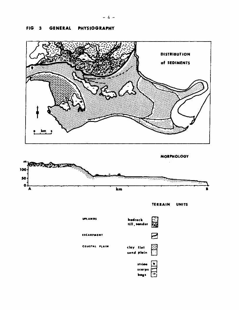
FIG 3 GENERAL
o km J , , t
100
50
- 4 -
'HYSIOGIA'HY
DISTIIIUT ION
of SEDIMENTS
MOIPHOLOGY
....................................... : .................. :.: ....... : .... :: ............ .. ...... : ....
OL-----~----~----~----~ __ --~~ __ --__ ----~----~----__ ----~~--~ A km 1
TfIIAIN UNITS
urlA.O, lIed,oek W tlll, .... du'
.. CA.' .... ' B COAITAL 'LAI" clay flCllt ~ aGnd p"in ..
atriee
~ ac.rpa
.... a

- 5 -
coastal processes. Although elevations range from 0 to 60 metres, the
region is almost fIat; most of the relief is taken up as small scarps
associated with strandlines and river terraces which mark positions of
former sea levels (Figure 3).
There are two major river systems, which constitute the
easterly and westerly boundaries of the field area. The Moisie river
flows through the foreland in a deep gorge, the valley of the proto~
Moisie. The preglacial channel reaches a maximum depth of about 600 m
and a width of about 2 1/2 km. In the post-glacial, it has been infilled
with about 250 m of sands. The upper 70 m have been terraced by the
present Moisie river, which flows from the foreland and onto the coastal
plain without any marked change in gradient. The Rapides river, in
contrast, is a recent system. There is no incised bedrock channel, and
the water drains southwards in a stepped profile over a series of water-
falls and rapids. Except for the southern extension of these two rivers
the coastal plain has not developed well-defined drainage channels. In
the sandy areas east of Sept-Iles water escapes by direct infiltration.
On the clay fIat, two shallow, steep-banked tidal creeks drain into
Sept-Iles bay. Much of the rainfall is absorbed by organic deposits which
overlie the clay fIat between Sept-Iles and Rivi~re des Rapides. 5tring-
bogs, extensive along the scarp foot have evolved an incipient drainage
system, but irregular ponds of standing water dot the surface. A discon-
neeted network of runnels allows soce of the water to drain outwards frow
the topographie centre of the bogs to scall coats which =ark the bog
periphery.

- 6 -
1.2 Bedrock Geology
Except for a small outcrop of Ordovician limestone located off
Caye-aux-Chaux, the exposed bedrock is of Precambrian age. The oldest
rocks belong to the Grenville series of paragneiss and amphibolite. The
paragneiss is made up of a large quantity of quartz, with orthoclase and
biotiLe. Near the contacts with later intrus ives , the rock has been
metamorphosed into a mica schist which is deeply weathered and crumb les
easily. Isolated outcrops of Grenville rock can be found along the
Moisie river. These rocks have been intruded by granitic gneisses,
which cover most of the area. The main constituents of this series are
red gr~nite gneisses, seme augen gneiss, and pegmatite. The latest major
intrusion is a band of Morin rocks, dominantly gabbro, titanomagnetite,
and grey-green anorthosite. This formation is found on the offshore
islands and around Lac des Rapides. The aeromagnetic map indicates that
these anorthosites continue along the scarp edge, beneath more recent
sands. Prior to the last glaciation a deep linear channel was eroded
into the granite gneiss. The channel is oriented N 450
E, parallel to
one of the joint patterns in the rock. Recently, it has fiUed in with
rubble. Daigle creek has eroded through the sediment, however, and 50
the channel is traceable fram Lac Daigle to the Moisie river. A local
anomaly on the aeromagnetic map suggests that the channel extends beyond
the Daigle area and cuts through the anorthosite at the scarp.
On the foreland the bedrock geolog)' is exposed as rounded knobs,
pol i.shed and abraded by g lac iers. ~;ear the coas t, i.n areas not covered
b:: cOclstal sands, grooves and striae can be observed, particularly in
- 7 -
the more resistant anorthosites. The location and orientation of these
features arE illustrated on the map.
1.3 Previous Work
Few people have investigated the physiography of the Sept-Iles
region. Nineteenth century explorers, including Hind (1864) and Richard
son (1870) commented on the landscape, but most of their observations
were confined to areas which were visible from navigable rivers. Others
(Kindle, 1922) noted the sand plain and a series of terraces but did not
investigate them. In 1947 the Quebec Commission des Eaux Courantes
levelled profiles of the Rivière des Rapides, gauged the utreams, and
mapped the watershed. In 1950 the Moisie river was similar1y surveyed.
The only other official regional survey has been conducteà by the Quebec
Department of Mines, which was principally interested in the solid geology.
Faessler (1942a, 1942b, 1945) and Greig (1940, 1945) examined much of the
North Shore but neither mapped nor described the zone between the Laurentian
plateau and the St. Lawrence at Sept-Iles. Laverdilre (1952, 1954, 1955a,
1955b) studied the region in greater detail but he was primarily concerned
with the identification of features, and not with the geomorphological
processes which produced the landscape. In 1951 the southern portion of
the Quebec North Shore and Labrador Railway was comp1eted, and railway
cuttings exposed some of the glacial materials near the Moisie river.
Woods (1959) and Pryer (1959) have published reports on the appearance,
origin, and engineering properties of these sediments.
1.~ The Present Study
The present investigation is a oore cooprehensive study of the
- 8 -
late Quaternary geomorphology in the region between Rivière des Rapides
and Rivière Moisie. The problem bas been approaehed by investigating
sedimentary environments, the eharaeteristie units whieh make up the
stratigraphie sequence. The physiography and geomorphological evolution
of th~ lôndscape are then explained by incorporating the environments
into a late- and post-glacial framework.

- 9 -
SECTION II
SEDlMENTARY ENVIRONMENTS
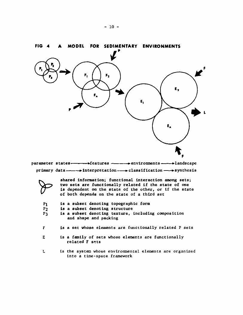
2.1 "Sedimentary Enviromnents"
A sedimentary enviromnent consists of a set of functionally
related sedUnentary features.
In the field, any discernible event can be described in terms
of its form, structure and texture. When the characteristics (states)
of these parameters are examined the event can be interpreted as a
specifie feature (or less optimally, a narrow range of features). An
assemblage of different features which are functionally related to each
other constitutes an environment. Consideration of the geographic~l
organization of environments produces a model for lands cape evolution.
The concept is summarized in Figure 4. Since the model consists of a
nested hierarchy of data sets and decisions, set theory terminology has
been used.
The concept has been implemented for several reasons. Firstly,
it describes the landscape in terms of basic elements which can be
observed ln the field. Thus, the description is simple and objective.
Secondly, the development of standardized field and interpretative
procedures produces a systematic classification of geomorphological
phenooena. Thirdly, by considering both unil{uc state (the para=leters)
and ::rutual dependency (functional relationships) the oodel seeks to
elicinate logical errors which lead to incorrect interpretations. In
- 10 -
FIG 4 A MODEl FOR SEDIMENTARY ENVIRONMENTS
l'
parameter states---_. .. features ---_. .. environments--... landscape
primary data--_. .. interpretation--. classification --.synthesis
F
E
L
shared information; functional interaction amang sets; two sets are functionally related if the state of one is dependent on the state of the other, or If the state of both de pends on the state of a third set
ls a subset denotlng topographlc form ls a subset denoting structure ls a subset denoting texture, lncludlng composltlon
and shape and packlng
ls a set whose elements are functlonally related P sets
ls a faml1y of sets who se elements are functlonally related F SP.ts
ls the system whose envlronmental elements are organized into a time-space framework
- 11 -
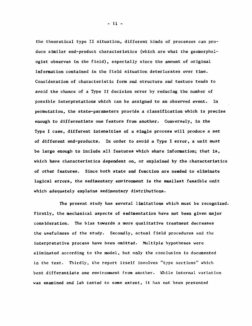
the theoretical type II situation, different kinds of processes can pro-
duce sfmilar end-product characteristics (which are what the geomorphol-
ogist observes in the field), especially since the amount of original
information contained in the field situation deteriorates over tfme.
Consideration of characteristic form and structure and texture tends to
avoid the chance of a Type II decision error by reducing the number of
possible Interpretations which can be assigned to an observed event. In
permutation, the state-parameters pro~ide a classification which is precise
enough to differentiate one feature fram another. Couversely, in the
Type l case, different intensities of a single process will produce a set
of different end-products. In order to avoid a Type l error, a unit must
be large enough to include aIl features which share information; that is,
which have characteristics dependent on, or explained by the characteristics
of other features. Since both state and function are needed to eliminate
logical errors, the sedimentary euvironment is the smallest feasible unit
which adequately explains sedimentary distributions.
The present study has several limitations which must be recognized.
Firstly, the mechanical aspects of sedimentation have not been given major
consideration. The bias towards a more qualitative treatment decreases
the usefulness of the study. Secondly, actual field procedures aüd
Interpretative process have been omitted. Multiple hypotheses were
eliminated according to the model, but only the conclusion is documented
in the text. rnirdly, the report itself involves "type sections" · ... hich
best differentiate one environment from another. While internal variation
was exacined and lab tested to some extent, it has not been presented

- 12 -
quantitatively, and gradational situations have also been excluded.
However, a detailed study at the initial stages is premature. The
following pages lay the qualitative, descriptive groundwork for the
recognition of ancient sedimentary environments in the Sept-Iles area.
2.2 Till
There is ooly one till sheet observable in the Sept-Iles area.
Deposits are exposed on the upper surface (above 125 m) as ground moraine,
end moraine, and modified moraine (consisting of reworked till).
Characteristically, the till is an unsorted, unstructured, unconsolidated
sediment consisting of sub-angular to subround pebbles, cobbles and
boulders in a light grey sandy matrix. These properties are illustrated
in the type section for ground moraine, located between Lac Daigle and
the Moisie river.
The type section for ground moraine is exposed by a road cut
located 4 km east of Lac Daigle, elevation 131 m asl. The till surface
is almost fIat, and covered by black spruce. Bedrock is encountered about
5 m below the surface.
The till is a compact, massive deposit of sub-angular to sub
round chattermarked boulders (up to 3 m diameter), pebbles, and sub
angular to angular granules in a light grey ( 10 YR 6/1) fine sand matrix.
Rock flour accounts for 10% of the -25 mm fraction. The lithology i5
local but variable. Granite, biotite gneisses and schists dominate the
pebble range; pyraxene, anortha5ite and gabbro are encauntered less
frequently. The lower part of the deposit is fissile and breaks into
flakes several cc thick. The upper cetre of the exposure is oxidized ta
- 13 -
a pale brown (la YR 6/3). There is also a greater percentage of fines,
possibly due to weathering and decomposition.
The till system acquires a variety of forms. A veneer of
ground moraine covers much of the area. The sheet varies in thickness
from a metres where abraded bedrock outcrops, to more than 5 m. Relief
is low and nn ablation features have been noted. Since the ground
moraine is fairly shallow, drainage is poor. Raised bogs or pools of
standing water occupy the hollows. A thick spruce vegetation grows on
the higher ground.
Broadly arcuate sub-parallel ridges are located to the south
and west of Lac Daigle. The sideslopes are convex and the crest is
hummocky. The highest part of the ridge reaches an elevation of 150 m,
producing a locsl relief of 20 m. In plan, the moraine is convex south-
0+0 wards, although the oversll alignment is N 70 E - 5 , perpendicular to
the striae found along Rivière des Rapides (N _20o
E and N -300E). The
feature i8 well-defined; the east-west termini have distinct 180 slopes.
It is traeeable for la km and the southernmost ridge is eontinuous exeept
for a wster gap at Lae Daigle.
The water gap has exposed a seetion of the ridge. Here, eobbles
are more rounded than in the type section. The tiii has oxidized to a light
brown-grey (2.5 Y 6/2). Granulometrie analyses show that the material is
better sorted, possibly as a resuit of entrainment of some of the eoarse
sands. Some of the large bouiders are assoeiated .. ith plastered structures -
s:nall wedg'e-like fort:la t ions conta in iog thio layers of sorted sediment 5.
The structuring is probably caused by hydraulic pressures generated around

- 14 -
immovable objects by southward-flowing outwash.
The till linmediately east of Lac des Rapides shows evidence
of modification. Here, the surface, although boulder strewn, is almost
fIat (elevation is 124 m to 125 m asl). The upper metre of the deposit
displays high angle laminar bedding. The amount of inclination and
direction vary but commonly the structures dip northwards. The gran
ulometric distribution in the top metre also indicates sorting. Thus,
it is suggested that a large portion of the very fine sand has been
selectively removed by competent meltwater which overflowed the Deschênes
channel at a time subsequent to the deposition of the till.
A railroad cutting at Rapides (elevation 67 m) has exposed a
till remnant lying between anorthositic bedrock and more recent marine
deposits. This till closely resembles the type section northeast of
Daigle, which indicates that the till is one morpho-stratigraphie unit.
plain
Lastly, a mantle of till underlies the deposits of the lower
Drilling information available for the Sept-Iles townsite
indicates that pockets of till 1 to 8 metres thick lie unconformably
over bedrock.
Figure 5 Borehole at the Docking Facilities
el. ID material
0 - -6 water
-6 - -24 grey silty sand
-24 - -~ grey 5ilty clay
-~ - -55 probably till
-55 - -63 igneous bedrock

- 15 -
Photograph 1
Crest of the south end moraine
. ("- .
t . Photograph 3
• 1
Daigle till type section
Photograph 2
Rapides reworked ti11 structures in the upper metre

- 16 -
30 l'pp. S.cti." • 1.23
1.9 2 -0.13
20
FIG 6 10
GRANULOMETR IC CHARACTERISTICS 0 -~ -2 0 2 4 6
OF TILL 2 S .... Me,.I". 30
1.00 1.15
20 -0.22
10
0 -4 -2 0 2 4 6
100 40 a A, •• ".. Till
10 30
80 20 0.00
2.44 .. 70 -0.50
• 10 • .. 1 60 1 u 0
~50 -4 -2 0 2 4 6
• ,. ::40 .! ~
130 . - ~O 4 •• p ..... Till
U ~ li
20 St. 30
o 23
10 20 , 6· o )9
0 10 -! -2 0 2 4 • • 10
.Nyel •• 114 1 .Ut [ cley 0
-~ -2 0 2 4 6

- 17 -
Summary
Plan and cross sections indicate that end moraine in the Daigle
area was terrestrially formed by ice which advanced from the NNW. The
topographic regularity, pebble angularity and local lithology suggest
that the till is basal, although the upper part of the ground moraine
could be ablation drift. The till rests on bedrock, and forms the
earliest deposit associated with the last deglaciation of the area.
Above 125 m asl it is overlain and partly reworked by outwash. At lower
levels there is an erosional contact between the till and overlying silty
clays.
2.3 Glacial-fluvial Outwash
The Daigle channel refers to a constricted rock-cut gorge which
bas been infilled with coarse sediment. The present Daigle creek, flow
ing northeastwards fram Lac Daigle to the Moisie river, has eroded through
67 metres of these outwash materials. Although erosion and downcutting
have dissected the deposit, the highest remnants still stand at altitude
128 metres, which is probably the upper limit of the outwash materia1s.
One of the channel walls has a potholed rock-cut 1edge at this elevation.
The outwash consists of a medium to coarse brown (7.5 or 10 YR
5/4) sand with abundant round to sub-round granitic pebbles and cobbles.
Towards the surface the pebb1es have an oxidized yellow patina (10 YR 6/2).
In the -25 cm fraction the sedicent seems to be finlng u~_ard5. If real,
this change ~y indicate a 1055 of conpetence due to a negatively changing
base 1eve1. At the exposure, however, the pebbles and cobbles seee core
nuoerous towards the surface.
- 18 -
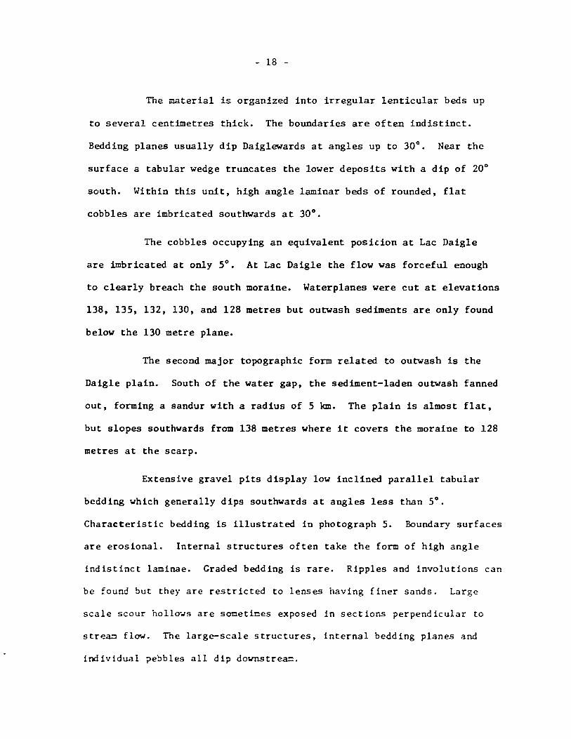
The rnaterial i5 organized into irregular lenticular beds up
to several centimetres thick. The boundaries are often indistinct.
Bedding planes usually dip Daiglewards at angles up to 30°. Near the
surface a tabular wedge truncates the lower deposits with a dip of 20°
south. Within this unit, high angle laminar beds of rounded, fIat
cobbles are imbricated southwards at 30°.
The cobbles occupying an equivalent position at Lac Daigle
are imbricated at ooly 5°. At Lac Daigle the flow was forceful enough
to clearly breach the south moraine. Waterplanes were cut at elevations
138, 135, 132, 130, and 128 metres but outwash sediments are ooly found
below the 130 metre plane.
The second major topographic form related to outwash is the
Daigle plain. South of the water gap, the sediment-laden outwash fanned
out, forming a sandur with a radius of 5 km. The plain is almost fIat,
but slopes southwards from 138 metres where it covers the moraine to 128
metres at the scarp.
Extensive gravel pits display low inclined parallel tabular
bedding which generally dips southwards at angles less than 5°.
Characteristic bedding is illustrated in photograph 5. Boundary surfaces
are erosional. InternaI structures often take the forro of high angle
indistinct laminae. Graded bedding is rare. Ripples and involutions can
be faune but they are restricted to lenses having finer sands. Large
scale scour hollo~s are socetices exposed in sections perpendicular to
streac flow. The large-scale structures, internaI bedding planes and
individual ?ebbles aIl dip downstre~.

- 19 -
Rock fragments show signs of weathering and stress. In the
top metre, the cobbles have been coated with a yellow-brown binder.
The layer has not been indurated, however, because of the wide range
of particle size and the higb percentage of voids. Most of the gneisses
shear easily. Often they are completely rotten and crumble in the hand.
Basic rocks have loose spal1s about 2 mm thick.
The size of the sediment ranges from a medium sand to boulders
2 metres in diameter. These boulders however are rare and rounded
cobbles 35 to 60 cm in diameter are the highest calibre commonly observed.
The shape of the particles varies from spherical (1:1:1:) to oblate
(4:4:1). The wide range of grain size, rapid vertical changes, poor
sorting and downstream imbrication (cf Gauri and Kalterherberg, 1966,
p.115) are indicative of a rapid loss of competence.
Summary
Outwash gravels accumulated in the pre-formed Daigle channel
at a time when the glacier was retreating northwards. The sediment was
transported far enough to be abraded into rounded cobbles, and the flow
was strong enough to breach through the moraine, where it spread out to
form an outwash fan. Rapid changes in structure and texture indicate
that flow was sporadic. The variation could be caused either by shifts
in the location of the channels or by changes in the glacial regime·n.
The sand sized fraction increases upwards and southwards in the depos1t.
Tne vertical change in granulooetric distribution together without
an increase in rounding cou1d ind1cate a l ... ,- 'ng sea level. Since the
teroina1 ~ode corresponds to the size of beach caterial it 15 further
- 20 -
Photograph 4
Daigle channel: a rock-eut channel filled with glaciofluvial outwash; looking NE
Photograph 5
Longitudinal section illustrating structures in the Daigle outwash
plc1in

- 21 -
FIG 7
GRANULOMETRIC CHARACTERISTICS
OF OUTWASH
CHANGES WITH DISTANCE
:l /ly
1.·-t: ~ 1/: 3
/ 1 • 7'0
/ 1 • • • • • 60 u / 1 -' 50 / /
• / il ~ - 40 1 J! :a 1 E 1 :a 50 1 u
/ 20 1/4 10 • • •
• ••
0 -! -~ Q Z 4 1 • lOi 1'''''' .. ft4 1 lilt 1 cley
30 1 Dal.l. C, .... -1 ••• '
20
10
0 -4 -z 0 Z
20
10
-2 0 2
40 a hl.l. ".1.
50
20
10
0 -4 -z 0 Z
40 4 D.I.I. PI.la 1
50
20
10
0 -4 -2 0 2
- 2.~0 2.25 0.09
4
- 0.6 (1
1.73 - 0·2.
- 0.17 1."
- 0.16
4
- 036 1 2. 0"
4
6
6
6

- 22 -
suggested that the sea was located close to the present extremities of
the outwash plain, i.e. near elevation 128 metres.
2.4 The Estuarine Sediments
Meltwater, laden with rock flour, deposited its sediment when
it reached the sea. These sediments do not occur as surficial deposits
since the surface has been eroded and reworked by la ter nearshore pro
cesses. Thus, the topographic form is not characteristic of the environ
ment at the time of deposition. Stratigraphic sections constructed for
the Sept-Iles area indicate that most of the sediment was deposited in
the form of a deI ta with the apex along the escarpment l1ear milepost 12
(Moisie River). Several types of sediments are associated with this
environment. Massive deposits of clays have accumulated in areas which
were deep or calm. In areas more susceptible to fluctuations in regime,
banded sediments are characteristic, while in shallow zones, fine sands
have buil t up.
These clays, and banded sands and silts underlie most of the
Sept-Iles plain. The formation aggrades upwards since the depositional
environment progressed from an offshore facies, to nearshore and coastal
as the land rebounded.
Sorne of the offshore fines are exposed along the Vieux Post bluff
at Sept-Iles. The section reveals a slickensided face of wet, grey (10 YR
4/1) claye;: sUt overlain bl' very coarse well-sorted sand. The deposit is
::J.ass i.·:c , and ver:: poorly sorted. Dry portions of the face abound in ',crtical
fisst;res. !:1e exposure is oversteepened (700
slope) and is thus condition
all~ unstable. Any disturbance, such as digging or heavy precipitation,

- 24 -
causes large slabs of sediment to shear off parallel to the face (photo
graph 18). Pockets of marine shells can he found throughout the section.
The drilling records for the townsite indicate that this section
is a subaerial extension of the uniform, very stiff to hard clayey silt
which underlies much of the area west of the airport. At its maximum
the deposit is 60 metres thick. The clay is normally consolidated; the
effective angle of internaI friction is 24°; water content exceeds the
liquid limite Strength, compressibility and clay content increase pro
gressively with depth.
The clay deposit has been eroded and replaced by a wedge of
coarse sands over the northwest end of the townsite. Farther west, however,
conditions were calmer and the clays extend to the surface (Figure 14).
In areas which were susceptible to changes in river regime the
sediments often appear as irregular bands of grey clayey silt alternating
with fine grey sand.
Banded sediments are found along the railway exposures from
Rapides to Moisie, and along the river to milepost 45. The regularity
of alternat ion, granulometric characteristics and thickness of the strata
are highly variable. In some areas large lenses of coarse sands have
been reported, while other regions record only a stratum of massive, soft
to stiff, fissured grey ailts.
These fine, rock flour type sedicents have infilled the pre
glacial ~isie valley. A drill hole at oilepost 19.3 was extended through
180 cetres of sedl=ent before bedrock was reached. The upper l1=it of the

- 23 -
FIG • • M ... I". IlIly CI.ya
30
VIEUX POST SECTION 6.U 2..5.
20 0·11
10
0 0 2 4 6 8 10
SilE AND SOITiNG DIFFEIENCES
100 100 21 •• cll 1 •• 4a
/ -0.47
90 ( 90 O.AtI 0.10
80
2 1 80 .--
.. 10 10
• 1
• .. • o 60 10 u
"'50 1 50
• 1
~40 40 -• -; E!O
1 30
~ u
20 20
1 10 10 ~ 1--
0 0 ~
-4 -z 0 2 4 1 • 10 0 2 4 6 8
., ... 1 •• IMI 1 allt 1 d~

- 25 -
banded sediments is 75 metres. Above this elevation they have been eroded
and overlain by coarser sands.
A 9 metre section of banded sediments is exposed at milepost 10
(elevation 59 metres) and continues to a depth of at least 27 m. The
surface has a capping of sand which slopes south-southwest. The sediments
are more or less continuous bands 6 to 10 cm thick, coosisting of soft to
stiff, fissured clayey silt between beds of grey sands. Dip is southwards
at 3, 6, and 120 at this location, although dips as high as 300 have been
reported. The salt content of the pore water ranges fram 0.8 to 4.6 ppm.
Moisture content exceeds the liquid limit and the clays are sensitive to
remoulding. The shear resistance varies between 1000 and 4000 lb/ft2 •
The weakest strata are characterised by a silty texture and low plasticity.
Thus, even over a small area there is a wide range in the physical
properties of the beds.
Where the face is weathered, banding is not generally visible.
However, fracturing occurs along the linear bedding planes. After rain
falls, the face is cleaned and fine sands are drawn out, leaving a skeleton
ccnsisting of distinct bands of silty clay (photograph 6).
Marine fauna have been found in isolated pockets of these sedi
ments. At milepost Il.4 shells collected at elevation 75 metres yielded
a date of 9140 ± 200 years.
As the elevation of sea level decreased relative to the land,
arcas forcerly in offshore zones were affected by nearshore processes.
So~e of the forcer sediments were reworked. As sedimentation continueG
caterials coarser in grain size were deposited. ~aves and currents ~ere

- 26 -
responsible for improved sorting and bedding of the strata.
The changes that occurred in the central portion of the delta
have been exposed along the 45 metre bluff south of the airport. The
topographie elevation is 50 metres; the surface is fIat and presently
vegetated with pine and vaccinium. Although the face is a single, con
tinuous unit illustrating a systematic progression, it can be divided
into three sections:
The upper 3 metres consist of brown, well-sorted beach sand having sub
horizontal (less than 6°) continuous bedding. This type of strata
alternates with 15 cm beds of high angle (30°) foresets which dip westwards.
Bounding surfaces are erosional. As depth increases, the sands become
finer, greyer and more poorly sorted.
The middle unit is an almost-vertical face exposing 12 metres of micaceous
grey sands and silts. Each stratum has a thickness of about 5 cm. The
apparent dip is 2 to 3° west; however, orthogonal sections show that the
maximum dip is 30° southwards. Thus, these strata may be transverse
sections of delta foresets.
Photograph 8 shows the details of the lower boundary of unit two. The
top is typical uniform strata, underlain by a series of silty clay laminae.
Below the clay, strata are no longer apparent but feathery ripple marks
become common. The lowest unit is exposed for 5 metres. It eonsists of
moist, eontorted. finer grey sands which are rieh in biotite and pl-logopite.
Sicilar sands and silts overlie the clay deposits at Sept-Iles.
Figure 10 has documented the progressive change in grain size observed
in one of the deep bore holes. The stratigraphie sections dra.n fro~ bore-

- 27 -
Photograph 6
Photograph 7
The lower boundary of unit 2: thick, sub-horizontal bedding
underlain by fine, ripplemarked sand
Type deposits at milepost 10: banded silty clays;
QNS&L photograph
The Airport section: beach sands overlying restructured
fine sands
?hotograph 8

- 28 -
1 Mil. 10 CI.y. 30 6.47
FIG , i.'1 033
20
GRANULOMETRie CHANGES IN 10
O. THE ESTUARINE SEQUENCE 0 2 4 6 10
60 2 l ••• , S •• 4. , MI4~1. S •• 4.
.--r-
~
40 3.70 3.30 0.74 0.'2 0.0' ~
-i).06
30
20 ~ -10
~
100 0 ~ h 1--
," ~
• 2 4 • 2 4 6 • •
90 • • 1 • 4 UIJ~" (hadl) ... 4. • 1 10 .. ; • , / 10 • • •
3' • 10 • • 1.77
70 • , 2 / • 0.,,' .. • • • , 70 -GA2
• • .. • • 10 • ,
!t • • • U • 1 • 10 • • 1 / .. 50 • • • 1 • 50 • • • ~ 40 • •
/ - • - •
j • 40 •
30 • • •
/ • u • 30 • • 20 • • • • 20 • • • tO • .
• 10 ..--
1 . • •
0 1
Il ,
-4 -2 0 2 4 • • 10 • 0
i .,.".1 "fttl 1 ,lM 1 cI~ 1 0 2 4 10

- 29 -
FIG 10 THE DEEP IOREHOLE AT SfPT -ILES
,. Coors., ~O 50 60 70 80 90 100 • Il 10 20 30
+10
2.63 O •• ,
0 2.17 0.1.
-10 c_, .. 1.114
3.07 0.12
-20
-30 3.40 0.53
E -~
.... 1 •• 4
c -50 .! .. • ~ -60 .!
III
-10 •• 70 2.0.
III.
-10
-90 C'",
-100
Mo"I' I.ct W.n'worth CI.ulflcotion

- 30 -
holes at the townsite and north of Mile 3 illustrate the extent and
gradient of the deposits (Figure 13).
2.5 Coastal Deposits
The abundance of material in the delta, as weIl as a continu
ing supply of sand from the Moisie system has furnished a record of the
coastal processes in the area. The highest deposits of beach sands are
found at altitude 128 metres, which has been interpreted as the marine
limit. Below this elevation, sands blanket aIl evidence of former
environments except where mass movement has re-exposed older materials.
The environment i5 made up of repetitive sequences of ridges,
troughs, and bay-fills. Differences in form are a response to a number
of input factors. Some of the major parameters are topography of the
parent surface, especially the initial land slope, changes in sediment
supply, and relative S~ leveI changes and rates of change (after
Zenkovitch, 1967, p.534-537).
The highest beach features are a series of prograding sand
ridges along the scarp. Sea level appears to have been falling steadily,
producing a vertical sequence of ridges parallel to the scarp fram
elevation 128 metres to 61 metres. Deposition occurred on a slope and
at a rate such that a trough corresponds in elevation to the crest of
the next lawest ridge. Thus, in cross section the deposit appears as a
flight of steps.
Longitudinal sections of the ridge crests reveal that the
original structure is weIl preserved: almost horizontal, continuous
strata are cooposed of ~ell sorted cediuc sands. ~nere finer offshore

- 31 -
deposits, associated with higher sea levels, have been churned up by
waves and incorporated in the longshore drift the granulometric dis
tribution records an increase in fines. Thus, particle size and
amount of sorting tend to decrease towards the scarp foot (Figure Il).
Along any given ridge, particle size also decreases towards the east.
This gradation has been interpreted as a loss of competence of a slow,
easterly flowing current. The hypothesis is supported by the fact that:
a) the ridges originate to tbe east of the Daigle outwash channel, a
major potential source of initial supply, and b) the ridge system splays
towards the east. In the Moisie area the crests are spread farther
apart and their form i8 less distinct.
An almost continuous blanket of sand overlies the central
portion of the delta. At Mile 3, QNS&L cuttings have exposed a 3 metre
section which shows the structures typical of beach sand. The surface
is fIat except wnere ridge and trough formations have developed. The
longitudinal sections, parallel to the shore, are composed of sharply
defined, continuous, sub-horizontal planar strata generally about 5 cm
thick. Transverse sections still display parallel strata but they dip
offshore at angles from 2 to 12°. For any given stratum, the sands are
~xtremely well-sorted but the particle size varies abruptly from one bed
to another. Stratification is also evident because of colour and
lithological changes; for example, marker beds of black ilmenite are
easily differentiated fram the more voluminous salt--and-pepper felds
pathic bands.
Six excavations of transverse sections of ridges indicate that

Photograph 9
Beach structures, type section at Mile 3
Photograph 11
- 32 -
Beach bedding at the marine 1imit, 128 m as1: internaI structures are recognizab1e but the information content at bounding surfaces i5 deteriorating (cf section 2.1 and compare with photograph
10).
Photograph 10
Cross-section of a beach ridge at Mile 3: seaward dipping beds, the back-bedded wedge and under
lying sub-horizontal bedding

- 33 -
FIG 11 TEXTUIAL CHANGES ALONG A SET OF PROGRADING
13 0
120
110
100 ,. Ê 90 -c .! 10 -• :. i! 70
60
50 .
IEACH IIDGES
§ 1'·2. HIill 0.69 O .• , 0.41
O •• 0J:: I.JO L....
0.77 0 •• 0 I.CJ -- lJ-. L 0.65
0.50 1 1.7J OA' - - - 2.05
O.JO
W 1
o 1 2 3 .. 5 6 7
Mean grain size decreases with decreasing elevation and wlth distance fram the western source area. The amount of sorting decreases with decreasing elevation and increases with
distance from the source area.
-+--- 'Ia. 1 ••••• '
' .. 11 •• un
'------_ C •• li •••••• , ....

- 34 -
2 M.,I". LI." 100 80
90 / 1 {
70 0.57
21 -0·55
10 , 60 0.09
~ 70 ,
• ~O
• ~ 1 u 10 40
~ ~ 1 30
• , > = 40 1 20 .--.! 2 , ~ E 2 30 la u 1
20 0 -2 0 2 4
10
0 -4 -2 a 2 4 6 a 10. g,.".1 IOnd 1 .1It 1 clay 1

- 35 -
the sub-surface has regular, sub-horizontal bedding. The ridges them
selves are formed of wedges of paraI leI strata which truncate each other
at low angles. 1be wedges are approximately conformaI to the surface but
they thin out along the flanks. The triangular deposit below the crest
between the wedges and the substratum are generally back-bedded cross
strata inclined at 4 to 10 0•
A complex foreland system is the main morphological unit west
of the airport. During formation of the foreland, the west2rn part of
the original delta was reworked and replaced by coarser, structured, beach
and nearshore sands. Boreholes at Sept-Iles show that the formation has
the geometry of a massive wedge with the thickest and deepest end under
the southern part of th~ townsite (Figure 13). To the north, the deposit
thins and at Vieux Post, for instance (section 2.4) the foreland sands
only occupy the upper two metres of the section. Where they extend into
the area presently beyond the Baie des Sept-Iles the beach deposits
finally become indistinct and interfinger with the finer deposits in the
former foreshore zones.
The system is composed of five distinct smailer forelands,
each of which consist of a set of beach ridges-and-troughs, and fIat
lagoonai deposits. The repeated ridge and trough sequence has given the
systeo a ribbed, sinusoidai topography. ~~reover, for each individuai
foreland, the surface ~aves are periodic, and amplitude and ~avelength
are constant.
Planimetrically, the ridges begin parallel to the shore in
the sa=e :=.anner as thos e on the escarp=ent; ho .... ever, the:; recur'Je se-,reral

m 40
20
FIG 13
Cr ... - s.cu ...
MACIOTOPOGIA'HY AND STItATIGItA'HY OF THE FORELAND
... , .................... """:'"'.'"""""",':','.,.'"".,,,,,.,.,.,. >~::~:~il:' ... r ... , .".];i?"0ffi!:;t:l"G}lld,j:,llidillBlB1"4 :,;:n:.;.;',. o~h:,:<ttji~~;hj;:-:""""I ?::l 1 1"' I~' 'J.;Of D~
-20
-40
-60
'~:-'''~ --- --''1,-, .1,_" '''; :" ____ ":', """ • ;- -: , ' ... ~,', ,', ..., ~ 1 ~''': ,. ... -'0
'r.'II. ., tho Sonel WH •• m
,: • . ........ ... ... . ...... ···········>ii\ ;;II:;:;'I;;;Iji[j j:i,:;: i: ~i;·;,;'~.)":
, ,~, .. , \ -.; I .. ~ ,- \' .... , ..
'.0' Sand
Silty
Till
"drock
, ... -,,,,,,, ............. . -40 1 _-,,";.:: /,'::, '''\'''' , -
~."",,, .... ~~ 1 ~ ".... "i/~\~ ...
-\ ~~,'" .. I· .... ~./I--60~\'
-10
-100
L_ -----
, ,,-
W 0\

- 37 -
FIG 14 MACIOTO'OGIA'MY AND STIATIGIA'MY Of TME
CLAY FLAT
Cro •• - S.ctlon. m
10J ~~~~~~~ o~ 1 -10
m
20
'ro'lI.
10 ;:::::::;:::;:::;:::::::::::::;::::«<: (=/</=»> :>:.; .. o
-10
-20
' •• t
CI.y
Son" ~ :::::
F

- 38 -
km east of Sept-Iles. Despite the change in orientation, individual
ridges within a given set remain parallel to one another except at their
tapered northern extremities, where they interfinger with each other and
with finer lagoonal sediments. The internaI structures of the beach
ridges are the same as those described in the type section, except that
the recurved portion of the striking longitudinal beds dips northwestwards.
Shallow troughs separate the beach ridges. These were initially
the spaces between successive ridges. The subsurface of the trough is
characterized by seaward dipping tabular, continuous bedding in accordance
with its origin as the foreshore extension of the landward beach ridge.
With time, however, the troughs have infilled with slope wash from the
ridges. The infilling of fines has rounded out and flattened the profile.
It has also decreased the permeability of the troughs by filtering and
lodging into the pores of the sand matrix. Since different plant
assemblages have subsequently colonized the ridges and the troughs, the
two features can be differentiated easily even in areas where differences
in elevation have become very small.
Beyond the zone of beach ridges, finer sands and silts have
accumulated in areas which were formerly offshore zones. The surface of
this bayfill deposit is almost fIat. The accumulation is relatively
unstructured except for occasional interfingerings of sorted sands which
constitute the offshore extension of beach ridges (Figure 14). ~orth~st
of the 3aie des Sept-Iles in the area ~ell beyond the foreshore, the
fines cocponent overlies the original deltaic sedicent, producing a
total clay accuculation core than 50 ~ thick (Q~SbL borehole ~ 6003).
- 39 -
Foreland formation has occurred several times at successively
lower elevations. With each fall of sea level a new series of beach
ridges has been produced. Each foreland can be identified according to
several criteria. Firstly, the orientation of the ridges changes from
one foreland to another. Secondly, the outer edge of each foreland is
marked by a distinct scarp in the foreshore area. Thirdly, the crest
trough amplitude decreases westwards from about 3 metres east of mile 3
to less than one metre at the townsite. There is a corresponding
decrease in wavelength and increase in ridge frequency. Lastly, the
overall slope of the ridge sets decreases westwards 50 that slope breaks
mark the end of each foreland system.
The composite fore land system is one of the major landforms
in the field area. This aspect of the coastal environment consists of
five different patterns of ridge-trough, lagoon and foreshore fIat
features. Each set of features was probably formed by the deposition
of the sandy onshore component of the longshore drift as berms, by con
tinued sedimentation of the finer suspended sediment component in the
calm offshore zones beyond the beach ridges, and by the subsequent
infilling of backshore lagoons. The spatial arrangement of the composite
foreland is probably closely related to the changing configuration of the
coast, brought about by the deposition of the previous ridge sets and by
changing sea levels.
2.6 Fluvial Accretions
Se'.:eral facies of fluvial envirorn:lent can be identified in the
eastern half of the field area. Sedi~nts associated ~ith channels of

Photograph 12
Cross-section of an interdistributary channel
Photograph 14
- 40 -
The Foreland: 6 distinct sets of beach ridges,troughs and bayfills
Photograph 13
Draped structures in an aeolian dune

- 41 -
FIG 15
REWOIKING OF THE I!XPOSED
DELTA SURFACE
100
10 l'Ir 1
10 1 1
70 ,
~ , S ~
1 1 10 / u
" ~ 50 1
2/ 1 • , • - 40 - / 1 JI :1
1 E :1 ~ / 1 u ,
20 , 10
, J
,/ 0
-4 -z 0 2 4 • • 10 p.wl .... ., 1 .m l c~
40
30
20
10
flUVIAL
1 1.,.," ... trl~u'.'Y
0.97 O.!<\!
-0.02
O+-'"T'""....,...-+--+-+-+-+--f===l~ -4 4
2 1'.1., .. , 30 -J.IO
2.13 -040
20
10
0 -4 "2 0 2 4
AIOLIAN
40 ~-1.97 0.71 0.0 1
30
20
10
o r- h -2 o 2 4
- 42 -
FIG 16 TEXTURAL CHANGES IN A
POl N T BAR DE POS IT
10
~ .0 /f· • • 10 •
1 ! • • • • • 7 • • •
J 1 • • •
10 1 • • • 1
• •
4' •
1 •
SC) • • • 1 • • •
40 1 • • • 1 • • •
!O 1 • • • 1 : 4
• 20 1 • • •
1 • • • 1 • • •
/ • • _/ • • • 0
-4 -2 0 2 4 1 • 10 •
1 1 J .,0".1 .ond • lit cloy
30
20
-4
4 2
30
20
10
0 -4
30 1
2D
10
0 -4
,. 4
l.U 40 060
0.15
30
20
10
0 ...
"2 0
-2
-2 0
2
0.77 I.ll
-0.30
4
-2.00 -1.61 - 0.l1
4
- 1.4l 2."
- 026
,--
r-
1 1
~
1
2 ..

- 43 -
low competence are found on the 50 metre surface of the delta in fIat
areas between aeolian dunes. The unit, illustrated in photograph 13
consists of about 3 metres of festoon trough cross-beds which are
elongated southwards and eastwards. AlI bounding surfaces are erosional,
and the base of the unit is anconformal as weIl. Although there is a
large variation in grain size from one bed to another, each trough is
composed of well-sorted sands substructured into tangential and inclined
foreset laminae (McKee and Weir classification, 1953) which are distin
guishable by small lithological differences, and by colour. The broad
fIat surface, and shallow festoon bedding of well-sorted sands suggest
that the sediment was deposited near base level by distributary channels
of the delta surface.
Elevated remnants of point bars are located along the lower
Moisie. Flat lenticular terraces of poorly sorted gravels lie unconform
ably on estuarine sands. The sediment is much coarser than the festooned
deposits and lies at a lower e1evation. At this stage, the Moisie river
was probably flowing in a definite channel; thus, it would be more con
fined and more competent.
The Moisie meander system consists of a series of continuous,
crescentic ridges and swales formed by lateral accretion (Allen, 1965,
p.138). The elevation of the system decreases eastwards fram the first
scarp to the Moisie at a rate of 2 1/2 metres per kc. The process of
point bar accretion is still continuing and spring flooding causes over
bank sed~entation. Several sections .ere excavated to reveal about
2 ~etres of gravelly cut and fill deposits. Sorting, grain size and

- 44 -
E .M
E .M
VI III U oC • III
• III ~
• 0:
III • > a: •
! ; ... • u
0 • ~ ... ~
c u
E 0 0 0 E 0 0 0
• .. or ..
E
.. .! • >
• .. .. ~
• ~ ~
o '" -
· · · • · ...
· .. &
E
E ..
o
•
M · · .. E
I~ ~ • j
1
c 8 0 0 ...
-- ------_ ....

- 4S -
packing are high1y variable (Figure 16). Genera1ly. beds are tabu1ar,
boundaries from one unit to another are gradationa1, and the bedding
is ungraded.
The most notable aspect of river morpho10gy is the terraces
which were formed as the f10w of water became confined. Bluffs have
been eroded into the de1taic surface both a10ng the meander and a10ng
the coast. A comparison of slopes and elevations shows that most of
the terraces on the right bank of the river are erosiona1, a1though
cappings of point bar gravels sometimes form thin surficia1 deposits.
The Moisie river has also incised the es~uarine accumulations which
infilled the proto-Moisie valley. A number of well-deve1oped terraces
have formed but no accurate surveys of this portion of the right bank
have been undertaken. Figure 17B is constructed from a survey based
on air photos. The estimated error is ± 4 metres.
2.7 Organic Accumulations
A large part of the area is covered with organic sediment.
Peat tends to accumu1ate in natural depressions when subsurface drainage
is restricted (Drury, 1956), and where rainfal1 and ground water are
sufficient to prevent aeration and decay (Auer, 1930, p.4). At Sept
Iles drainage is impeded by near-surface deposits of impermeable clays
and by hardpan formations in the sands. (The hardpan is both a cause
and a result of reduced soil permeability).
~~erous snall bogs, .ith diaoeters less than 300 0, are
coonon on the upper surface. rney can be found prioarily in bedrock
depressions but they are also infilling Lac Daigle outlet and one of

- 46 -
the inlets, a former ice marginal channel. On the lower plain, there 15
a general organic build-up on the clayey flats north of the Baie des
Sept-Iles. The thickness and regularity of the accumulation has already
been illustrated in the cross section, Figure 14. On the sandy parts,
elongated bogs have located along stream courses and depressions which
lie parallel to the recent beach ridges: such bogs are incipient along
the beach south of Maliotenam. Drier, deeper bogs are located between
the former foreland ridge sets. The largest, 15 km long, lie on the
terrace back slopes between the foreland and the escarpment. These can
be classed as raised string bogs. The cross-sectional shape is convex and
the margins are abrupt. Growth occurs in aIl directions fram several
initial centres of accumulation and the entire formation becomes elevated
ab ove the surrounding land. Drainage is basically centrifugaI, and water
flows into a moat (lagg) which runs ûround the periphery of each bog.
On the straight-sloped zones (Allington, 1959) the bog surface
i9 ribbed with strings. These consist of well-defined arcuate ridges of
sod and vegetation, which are concentric to one of the initial cores.
The strings, about 50 cm in height and width, account for most of the
microrelief. The remainder i5 due to grassy earth hummocks which are
located on the 5teeper restricted slopes along the ridge flanks of the
foreland formation.
Permeability varies on the bog surface. Fines have percolated
into the lower areas between strings, restricting the infiltration of
~ater, 50 that the bog surface is dotted by irregular pools of standing
water. At the base of one of the bogs exacined a 15 co layer of greasy

- 47 -
organic clay underlies the peat. This layer has effectively reduced
the permeability of the sandy subsurface, and the watertable of the bog
is perched ab ove the local table which, in this case, has been determined
by a drag line. Thus, the peat itself, as well as the microrelief has
contributed to the permeability changes in the soil.
Structural and textural characteristics of the bogs were not
examined in 1969-70. Changes in pollen composition should be comparable
to Bowman's (1930) core for the Matamek area, 25 km east of Moisie. His
results are retabulated in Figure 18. Several features should be noted:
1) the presence of sedge in the lower 5 ~ feet of the section indicates
a stage of development characterised by open swamps with scattered clumps
of trees. In its later stages the entire area was covered by trees (Bow
man, 1930, p.702-703).
2) there are six spruce-fir maxima which correspond to levels of
sphagnum minima. These oscillations are "reflections of climate changes"
(Bowman, 1930, p.706).
3) the incidence of hemlock indicates a warm, moist period. It is
followed by an increase in spruce which represents a "deteriorating
climate" (Potzger, 1953, p.399).
Surmnary
In its initial stages, the accumulation of peat oodified the
pri::lB.ry sedir::1eotary envirorunents by subduing the topography and cnanging
t:;e per:::eabilit:; of the underl:;ing soil. ,\5 de'leIo~nt continued,
organic accu::lUlations d€· .. ~loped into a distinctive environ=ent with a
t;nique set of :::icro-for:::. drainage. and texturaI characteristics.

Photograph 15
Microtopography: string and desiccated pool which ha~
infilled with fine sediment
Photograph 17
- 48 -
Macrotopography of the scarpfoot bag: subdued relief
Phatograph 16
Restricted basal drainage: greasy organic clays separate
the peat fram the underlying beach sands

lM: o ... lit ... ~ ... o lM: ... z ... ~
~
o ...
• -
- 49 -
'"
& _ " " • ~ • h • • ! = • 1 ...
i
~ . • .. o
0.R-•
i .!
~ . • .. o ..
a è
i il
~ 1 / 1\/ "1
- ~ ~ • ~ • ~ • • 2 =
• ~ r ...
• -; ;
o • ...
o CI

- 50 -
2.8 Modification Morphology
In a study seeking to explain the appearance of a lands cape
it is necessary to consider factors which have modified the major sed
imentary environments. At Sept-Iles three factors account for the
residual features: aeolian activity, 50 ils development, and mass movement.
aeolian modification
The dune field has a total area of about 25 square kilometres.
It is located on the portion of the sandy delta which has an elevation
greater than 50 metres. The field consists of almost 300 irregular
ridges and hills. On the ground, no directional alignment can be
established; however, an air photo analysis of unit-length components
indicates significant preferred orientations at N 75°E and N 105° E.
The crests of individual dunes are rounded, and slopes are
smooth and fairly gentle (less than 20°). Relief varies from 2 metres to
6 metres and interdunal areas are fIat.
The structure as a whole shows conformaI anticlinal bedding.
The strata, however, are thick (50 cm) tabular segments. The angle of
inclination varies from almost horizontal near the base to a maximum of
34° on the flanks. Each stratum is composed of a set of parallel laminae
several centimetres thick. Anticlinal structures are often draped
(photograph 14), that is, skewed 50 that the present topographie dune
crest does not correspond to the underlying structural crest, but lies
to the ~est. It has been inferred that the sand-=oving winds originated
in the east.

- SI -
The dunes are composed of a ye1low brown (10 YR 6/8) soft,
si1iceous sand. There is no trace of the Iron partic1es found in the
parent materia1. The granulometric curves (Figure 15) show that for
a given stratum, the material is a weIl sorted medium-grained sand.
Variation between strata is a1so very smal1. Individual grains are
sub-rounded and show signs of frosting.
The dunes provide information about environmenta1 conditions
prevailing at the time of their formation. When base 1eve1 was at 50
metres as1 the delta was sandy, dry and unvegetated. Sand moving winds
originated in the east and began to entrain partic1es when the ve10city
exceeded 4 metres per second.
soi1s deve10pment
The development of a soil has a1tered the mineralogy, strength,
and porosity of the upper portion of the primary sedimentary environments.
Despite differences of elevation (and hence length of time for develop
ment) aIl sandy soils have a similar depth and apparent degree of develop
ment. These soils are classed as orthic humo-ferric podzols (Canada
Department of Agriculture, 1970. p.105-109). The L-H horizon ranges in
depth from 0 to 15 cm and consists of brown-black mor-type 1eaf 1itter
and twigs under1ain by a black layer of fibrous, part1y decomposed organics.
Leaching has a1tered the co10ur and minera10gy of the under1ying sands.
An Ah horizon grades into the ashy-white Ae horizon, a granular, siliceous
zone about 20 cc thick. This horizon is abrupt1y underlain by a rusty
brown Bf zone, which reaches a maxtcuc thickness of sa c~. On recently
exposed sands, this horizon is friable. On the till and ou~·ash deposits

- 52 -
of the upper surface it is firm, and the sand grains have brown coatings.
On the beach plains this zone is indurated. The cementation is attributed
to the presence of Iron bearing mineraIs in otherwise siliceous sandy
materials (Chrosciewicz, 1962). Since the beach sands are laden with
magnetite (Laverdière, 1955) as weIl as biotite and hornblende, ferrous
solutions would be leached out of the A zone during podzolization and
precipitated as ferric salts which serve as the binding material between
individual sand grains (Chrosciewicz, 1962, p.20-22).
Induration has had several major effects. Firstly, the porosity
of the sands has been reduced, and in some places the hardpan has been
held responsible for poor drainage conditions and subsequent peat accum
ulation (Welsted, 1960, p.93). Secondly, although the sands yield easily
along the structural planes of primary sedimentation, the ironpan shows
increased resistance to vertical stress. Lastly, as weIl as altering
the physical properties of the sediment, the hardpan has a special signi
ficance: by inhibiting the movement of iodividual soil particles induration
has tended to preserve the original sediment structures.
mass movement
Several fossil forms indicative of mass movement can be seen
on the air photos. Firstly, the major scarps shows a series of amphi
theatre scars between Daigle road and Rapides. Secondly, there are
several circular gully heads and accumulation fans along the silty-sand
terraces of the lo .. er plain. The largest has a diaoeter of 480 eetres.
The Q~S&L railway runs along the bottoe of an old pear-shaped flo .. slide
fro~ cilepost 8.5 to Il.4. The cajor and einor axes have dicensions of

- 53 -
3.8 and 1.6 km respectively. The backslope has a present inclination
of 34°, and the lowest elevation of the failure surface is 30 metres.
In general, the topography is hummocky and the bedding in the banded
sediments has been disturbed.
Slope failures have also occurred quite recently. "During
the excavation of the tunnel (milepost Il.4) in 1951 a short section
of the roof near the south portal collapsed and allowed the overlying
sediments to subside. Some 60,000 cubic yards of banded sediments
entered the tunnel in fluid condition" (Pryer, 1959, p.65). In 1953
and 1954 rotational slips oc~urred in a cut slope. The first incident
followed a heavy rain and failure was attributed to the development of
hydrostatic pressure in the permeable (sand) strata. In the second case
a combination of rain and snowmelt had raised the water table.
Major failures have occurred in the banded sands along the
Moisie river during the last twelve years. In 1959, 200,000 cubic metres
of fluid sands flowed out from the left bank at the meander, temporarily
blocking the river. In 1966 another 3 1/2 million cubic metres failed
after a rainfall of Il cm. This flow probably resulted from the
instantaneous liquification of the entire silty-sand mass (based on
Q~S&L data). An artesian system developed; the flow continued for five
hours, until the pressure was relieved in the side walls of the gully.
Lnlike the previous cases, the flow scar has the form of a we11-deve10ped,
dendritic gu11y system. Due to its unique morphologica1 characteristics
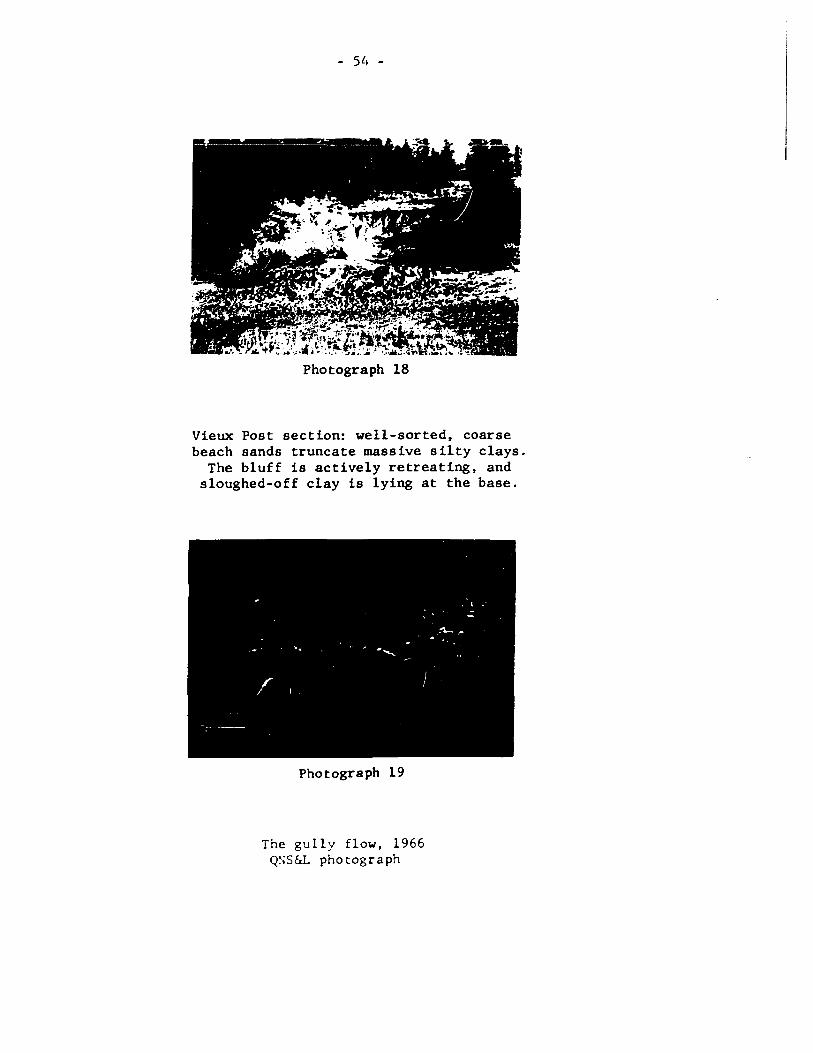
the fai1ure has been cal1ed a gu11y f10w (photograph 19). The details
of the stratigraphy (appendiY. S.lS) indicate conditions prone to fai1ure.
Photograph 18
Vieux Post section: well-sorted, coarse beach sands truncate massive silty clays.
The bluff is actively retreating, and sloughed-off clay is lying at the base.
Photograph 19
The gu11y f1ow, 1966 Q~;S&L photograph

- 55 -
At present, the banks are 30 metres high and have side slopes at 30 to 40°.
The gully walls are composed of banded sands. Within these bands are
layers of organic material, irregular bedding planes, and zones of fine
homogeneous sands which tend to reduce permeability and permit pore
pressure to become excessive. In addition, the basal deposit is deltaic
silty-clay. Its surface may have become lubricated and acted as a basal
slippage plane at the time of failure.
Failures, then, expIa in part of the morphology of the land
surface. On the other hand, it is the morphology and arrangement of land
scape components which produce initially unstable conditions. The
incidence of failure depends on the nature of the materials, which has
been discussed in this chapter, and on the stratigraphie distribution,
which is the subject matter of the next section.

- 56 -
SECTION III
THE EVOLlIT ION OF THE LANDSCAPE
The characteristics of six sedimentary environments have
been described in Section II. When the order of deposition and the
spatial distribution of the environments are also considered the
extended sedimentary model provides one type of explanation of the
landscape. Section III has been divided into three parts, although
the subject matter is interrelated. The first subsection introduces
a secondary model, which describes the pattern of pûst-glacial
emergence. The second part presents a stratigraphic column and
summarizes the events which have contributed to recent lands cape
development. The last subsection puts the landscape into a broader
perspective by examining the inter-regional correlations. The uplift
equation has been used in this section to establish absolute age limits
for the sequence.
3.1 Postglacial Uplift
Postglacial uplift is inherently connected with the evolution
of the Sept-Iles landscape. Relative sea-level changes have affected
the form, composition and structure of features, and their spatial
distribution. The position of former waterplanes is well marked in
the Sept-Iles area: beach strandlines and a series of terraces ~rk
the position of forcer sea levels. In addition, two radiocarbon dates
are available, although both are associated with offshore deposits.

- 57 -
This radiocarbon information has been used to construct a simple model
which should approximate the general form of the uplift curve. When
the form of the emergence curve is known, approximate dates can be
assigned to the marine limit and the lower strandlines, and the
general pattern of emergence can be discerned.
assumptions
The mode1 is based on four assumptions:
1. It is assumed that postg1acia1 recovery is a re1ative1y sUnple
ttme/e1evation response (after Andrews, 1970, 15). Nye (1952, 529)
and Weertman (1961, 961) have shown that the mass and geometry (hence,
the amount of depression) of a glacier can be expressed by very sLmple
equations. According to their argument, the expression for isostatic
recovery should also be simple.
2. Secondly, it is assumed that the marine lLmit was formed at the
tUne of deglaciation. The morphologica1 characteristics of the end
moraine indicate that it was formed terrestrially. However, the
location and granu10metric characteristics of the outwash deposits
indicate that the glacial-fluvial sedLments on the upper surface
emptied into a nearby sea. Thus, the marine limit was probably approx-
imately synchronous with deglaciation.
3. A third assumption is that the radiocarbon dates are correct, and
that their elevation can be associated with a sea level stand. Olsson
and Blake (1962, 47-64) have discussed the technical probl~s associated
with dating. The data available at Sept-Iles does not ceet the second
+ par~ of the ass~ption. A date of 9140 ~ 200 (GSC-1337) ~as oota:ned
- 58 -
for shells at elevation 76 m asl. The swmple was found in a deposit
of marine clay which may have been truncated by nearshore sands. From
the shell-bed stratigraphy and faunal assemblage, it is not possible
to establish either the depth of water at deposition nor whether the
shells were deposited during a transgressive or regressive phase. A
wood sample extracted from a nearshore deposit of coarse delta sands
(el 27 m) was dated at 6300 (GSC-1482) years. The dating problem
prevents an exact curve from being con8tructed 50 that the empirical
equations developed below should only b~ regarded as a first approxUn-
ation.
4. Lastly, it i8 assumed that an accurate sea level adjustment can
be applied to the data. In order to calculate uplift and emergence,
it is necessary to correct for eustatic changes. Shepard's smoothed
curve (Shepard, 1963, 574-576) was used in this analysis; however, the
curve neglects fluctuations in sea level due to minor changes in glacial
volume (Bryson, 1969) and does not compensa te for offshore loading
(discussed by Bloom, 1967).
the basic model
Farrand has plotted a series of uplift curves for central and
northern Canada. He found that "the most intensive uplift ..::.oincided
with the time of deglaciation" and that the rate of uplift decreased
from that time onwards (Farrand, 1962, 195). Tanner (1965, 427) expressed
the s~e idea in an equation deve10ped on a theorctica1 basis:
dh dt = -k'h (1)

- 59 -
Equation (1) states that the rate of rebound (dh/dt) is proportional
and opposite in direction to the amount of depression. The equation
can be integrated in order to find the amount of rebound remaining (h):
f 1 dh = ! -k'dt ( 2) h
. ln h = -k't + constant ( 3) . . . h = Ce -k' t ( 4) . .
Using common logarithms (for linearity) the equation becomes:
( 5)
''h'' is the amount of uplift remaining "t" years after deglaciation
"c" is the total amount of postglacial uplift relative to sea level at deglaciation, and is equal to the elevation of the marine ltmit plus the sea level correction factor
''k'' is an empirical constant, equal to ''k'" multiplied by 10glOe
"t" is the time elapsed since deglaciation, in thousands of years.
At present the available data i8 not accurate enough to plot
an exact linear equation. However, a reasonable fit can be achieved
by graphing solution areas. When the equation is plotted both radio-
carbon data points must lie to the left of the line since they were
dep08ited in underwater environments.
As a first approximation, the marine limit was assigned an
age of 9140 years, and the appropriate curves were drawn, knowing
that the elevation of the marine limit is presently i28 m asl. When
the equation is plotted, bath samples are located ta the left of the
line. Shells occupy a deep water location and the wood lies in a
shallow water position.

- 60 -
FIG 19 CALCULATION OF THE UPLIF T CURVE
b ... d on .qu.tion (5)
200
LOCUI of th. 9100-Y •• r Sh.1I
E -r ë • E
LocUI of th. 6300- Y.or Wood e • -. ---CL
:» .. ~
10 1" .pproximati ... -~-~"'
5
, o 2 3 4 5 6 7 • 9 10
t: Tlm. Sinn Dellaeiatlon C lit 10' l')
- - - Loci and Upllft Curve Aceordl... to Iry .. ,,', S.. Lev.1 Corr.ction

- 61 -
Second1y, the marine 1ünit was assigned an age of less than
9140 years, and the appropriate curve was drawn. In this case, the
position of both the wood and marine shells are shifted leftwards. In
order that the wood retains a shallow water location, however, the value
of "t" must be greater than about 8000 years.
Thirdly, the marine limit was assigned an age greater than
9140 years. In this case, for t greater than 9300, the corresponding
position of the wood sample shifts to the right of the line. Thus, the
maximum date for deglaciation according ta this data and Shepard's curve
is 9300 BP. (When Bryson's sea level correction is applied in a similar
manner, the date becomes about 10,000 BP.)
implications of the ''k'' value
The k value, the slope of the curve, represents the rate of
uplift, which is variable over tUne. The terminal value of k, derived using
a t-value of 9300, is 0.24. Although this value is sUnilar to that obtain
ed for the Lac St. Jean area (0.23) (Andrews, 1970, 61), it is greater
than the result obtained for the Laurentide iee sheet as a whole (0.17)
(Andrews, 1968, 41). The difference may be attributed to imprecise data
and to problems with the model. It eould also mean that the time sinee
deglaciation is too small to aeeount for the amount of uplift (i.e. the
inereased k value would eompensate for a small value of t in the equation
:~o. 5) . In th is case a readvanee may have oeeurred dur ing the major per iod
of deglaciation. The uplift would then be the result of the oversll
pattern plus the rebound following the final minor deglaeiation. To
test this idea, Andrews' Laurentide k-value of 0.17 was used in the

- 62 -
equation. 3 The time since deglaciation now becomes 12.5 x 10 years,
which is the value that Prest predicted for the Sept-Iles area (Prest,
1969, map l257A). If this date represents the time of effective
deglaciation, then the entire exposed Sept-Iles sequence was deposited
after a late-glacial readvance. The graphed time since the last
deglaciation, however, agrees more closely with Bryson's date of about
10,500 years, which he obtained from an extrapolation of dated marine
limits and a Laurentide sea level curve (Bryson et al., 1969, Figure 2).
In this case, there is no argument to support the theory of a readvance
on the basis of the model.
the general pattern of emergence
In Figure 20 the uplift curve has been transformed to an
emergence curve by algebraically adding the amount of sea level rise
according to Shepard's curve.
The Sept-Iles area has a series of well-marked waterplanes
whose elevations have been determined by altimetric traverses. Traverses
were also run in the Ste. Marguerite river area. There were no discern-
able changes in the elevation of the major terraces; therefore, it is
assumed that uplift is approximately right-perpendicular to the coast.
The waterplanes are associated with sandy beach deposits or with terraces
marking the location of former river mouths. Thus, the terraces mark
forwer positions of sea level, which can be dated by reading off their
age directl:. fro= the e:::ergence graph, The pattern of e:::ergence of the
delta and the developc:ent of the terr'aces is presented in Figure 21.
The nt=erical ';alues of ~he isochrones are tentative, The general

FIG 20
150
140
130
120
110
100
• 90 D
Ê c 10 0 -D :.
70 .! III
60
50
40
153
- 63 -
UPLIFT AND EMERGENCE CURVES fOI SE'T-ILES
Upllft a.maininll
-0.24t-U~= 153'10 (1)
- 0.24 = ,.,,,,11 •• , v.'u • • 1 k
Il) Acc.,,.,,,. ,. Sh.~.,"· a S •• L.y.' CU,y.
Em.rgene.
aemaini"1I 30
20
10
10 l Yeara
2 3 4 5 6 7 1 9 Sinee Deg/ae.
1 1 1 1 1 1 1 1 1 l' 9 1 7 6 5 4 3 2 0

FIG 21 THE PATTERN OF EMERGENCE
~, ~
.::::: ... " 0 .... ~ \ 0 -'5-o _
, tr \
\ ~
'>1' . , \ cr~ , , \ \
\
\ , ...
6' E levallon of Water plane. (m)
8.0 Dol. of Emerl.nc.C.10'.')
L _______ _
,.3 - -. 0 . 0
,~
\ \. ,
\ , .. ~''''
... - - --
Original Delta Surface
o lem 5 ,
, , , , li 45
1
" b.'
f
(J"\
"'"

- 65 -
pattern of emergence, however, will apply even though the dates may
be incorrect.
1. The curve shows that emergence has continued since the time of
deglaciation. This conclusion tallies with the progressive upward
coarsening recorded in the offshore boreholes. If deglaciation
occurred 12,500 years ago, the Sept-Iles (surface) till represents
a readvancewhich postdates that time and antedates the marine deposits
of 9300 BP.
2. The emergence curve and isochrone map indicate that the amount
of relative uplift decreases with time.
3. Although the lower waterplanes are closer together altitudinally
than those at higher elevations, the time elapsed between successive
planes is greater.
Since the Sept-Iles area has always had a supply of trans
portable sediment from the Moisie river and the delta-plain itself,
the waterplanes should only be the result of major changes of river
regime or glacio-eustatic activity. Since the terraces are distinct,
it therefore seems that the rate of emergence has not been constant
and that successive iso-eustatic adjustments have been decreasing both
in magnitude and frequency.
conclusion
The Sept-Iles are a has a set of well-marked beaeh and river
tcrraees. A sioplc deeay wodel has been develo?cd to deseribe the
chronologieal cvolution of thcse waterplanes. The Dodel only eonsiders
the eoergence that has oecurred relative ta the present sea level.

- 66 -
Thus, it does not aeeount for underwater terraees whieh are roughly
suggested by the bathymetrie ehart. When more age determinations have
been obtained the aeeuraey of the model ean be improved and the form of
the model ean be modified to inelude the effeets of residual and
restrained rebound.
3.2 Stratigraphie Summary
There is little unequivoeal information about the situation
whieh existed in the period prior to the last deglaeiation. The sea
must have extended inland at least as far as the foreland escarpment,
and at seme time it may have reaehed the Laurentian Plateau, about
30 km north of the present coast. The proto-Moisie was the main pre
glacial river in the area. Its valley reaehed a width of about 2 1/2
km and a maximum depth of 550 m where it ineised the plateau at mile
post 26. Rock-eut gorges, sueh as the Desehênes and Daigle ehannels
were probably the major, south-easterly flowing distributaries. The
drainage system may have extended into the strike and dip faults between
the offshore islands or through a submarine valley south of Maliotenam
(visible on the Hydrographie ehart No. 1214, 1967). The topographyof
the shield was probably hummoeky and mueh the same as it is today. A
weathered layer more than several eentimetres thiek probably eovered
the surface (based on an analogy with present weathering and on the
nature of the tills). When the area was glaeierized, the weathered
~antle (providing it was not frozen solid) was ineorporated into the
iee. Sands at the base of the glacier would aet as abrasives 50 that
nueh of the area was seraped elean and polished although the iee itself
:::.ay not have had a great erosion-capability.
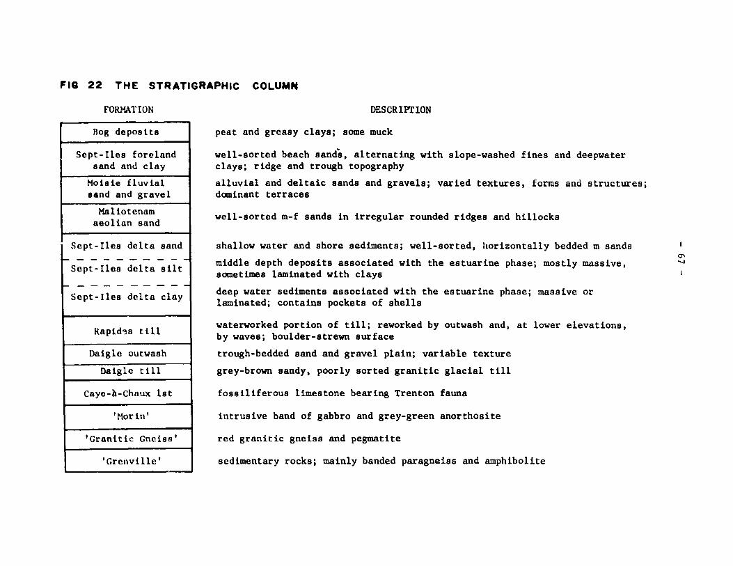
FIG 22 THE STRATIGRAPHie COLUMN
FORMATION
Bog deposlts
Scpt-Ilcs foreland sand and clay
Moisie fluvial sand and gravel
Haliotenam aeol1an sand
Sept-Ilcs delta sand ~---------
Sept-Ilcs delta silt
~---------Sept-Iles delta clay
Rapid~s t 111
Daiglc outwash
Daigle t i 11
Cayc-à-Chaux lst
'Morin'
'Granitic Gneiss'
'Grenville'
DESCR 1 Pl' ION
peat and greasy clays; some muck
well-sorted beach sands, alternating with slope-washed fines and deepwater clays; ridge and trough topography
alluvial and deI taie sands and gravels; varied textures, forms and structures; dominant terraces
well-sorted m-f sands in irregular rounded ridges and hillocks
shallow water and shore sediments; well-sorted, horizontally bedded m sands
middle depth deposits associated with the estuarine phase; mostly massive, sometimes laminated with clays
deep water sediments associated with the estuarine phase; massive or laminated; contains pockets of shells
waterworkcd portion of till; reworked by outwash and, at lower elevations, by waveSj boulder-strewn surface
trough-bedded sand and gravel plain; variable texture
grey-brown sandy, poorly sorted granitic glacial till
fossiliferous limestone bearins Trenton fauna
intrus ive band of gabbro and grey-green anorthosite
red granitic gneiss and pegmatite
sedimentary rocks; mainly banded paragneiss and amphibolite
0\ '-J

- 68 -
final glaciation
Sorne time prior to deglaciation, an ice sheet advanced south
south-eastwards frorn the Laurentian Highlands across the Sept-Iles
region. The presence of this ice sheet is documented by glacial
grooves found on the outcrops along Rivière des Rapides, and by the
veneer of sandy granitic till which directly overlies the bedrock.
The southern limit of this advance, and its configuration are unknown,
but the ice front extended at least as far as the Sept-Iles archipelago,
and possibly continued far out into the Gulf.
The sequence of events which produced the envirnnments des
cribed in the previous sections are summarized below. At Sept-Iles no
evidence has been found to suggest that deglaciation was cornplicated
by minor ice advances or by marine-transgressive phases.
Retreat of the ice sheet occurred about 9300 years ago. This
event is recorded in the deposits of till and outwash located on the
upper surface. The Daigle moraine, a multicrested end moraine, was
terrestrially deposited by actively south-easterly flowing ice during
deglaciation. When the ice front was in this position, some of the
melt flowed away through a small ice marginal channel which probably
drained eastwards into the sea. As the ice melted the veneer of local
till was deposited. As the ice front retreated northwards, the volume
of available melt water increased. These waters were concentrated
into deeply incised channels associated with the proto-~oisie drainage
s::ste::l. Daigle channel (and the southern ~1oisie) probably served as thE!
first conduit, at a tLoe when the ice front was ~ediately north of

- 69 -
the Daigle-Moisie confluence. The Daigle channel rapidly infilled
with coarse materials. For a short time, the passage of water must
have been blocked by the south moraine, because a series of waterplanes
were cut into the north slope, and outwash pebbles were deposited in
the inter-morainal area west of Lac Daigle. A water gap was soon cut
into the moraine, however. The melt water, no longer confined, rapidly
lost competence, and deposited the coarse fraction of its sediment in
the form of an outwash fan in front of the moraine. During the final
stages of its buildup the outwash plain must have been coterminal with
the sea because the outwash has the texturaI characteristics of beach
sands near the scarp.
As the Daigle channel was filling up, the Deschênes channel
received abundant melt waters. Since the sediment in the channel
bottom is fairly fine the ice front by this time was probably far
enough to the north for the very coarse material to have been previously
deposited. The overflow from the channel, however, in combination with
~elt waters flowing southwards through the developing Rapides river
channels, was competent enough to remove the fine sands from the till
at Lac des Rapides and to restructure the upper metre of the deposit.
estuarine phase
The final stages of deglaciation occurred about 9300 BP.
:':1<.; ?rt!t; lac ia1 :'~o is ie: · ... .15 drowned a t th is t i:::e .:lnd an ar::: of the s(:a
t.:x~ended 'J? ::le ':.111(::; :or il distil:1CC of ::;ore :hiln 60 b.. Y..oc;': flour
ilnd a11u';ial sa.,ds i:;fill(:d tht:! ~<oisi(: gorge to 75::J asi. Th(: n.:::::lai:1-
der ai t~e sedL=e:1t ~as depos~tt:!d i:;to the open sea anè a 1ilrg(: c(:lta

- 70 -
was built up along the escarpment. The most rapid build-up occurred
south of the Moisie river, but the suspended outwash and Rapides river
alluvium also contributed minor amounts of sediment to the delta. The
delta consists mainly of silts and clays. In some areas, where the
water is saline, the clays tend to be massive. Closer to the Moisie
river, the clays are banded. These bands may be related to the brackish
nature of the water, to changes in river regimen, or to secondary turb
idity currents.
post-glacial emergence
The estuarine phase lasted long enough for a well-defined
marine limit to form.
At the time of deglaciation, the crust was depressed about
130 metres below the present sea level. Since that time, rebound has
been occurring faster than the sea level has risen, so that in the post
glacial period emergence has been continuous (cf section 3.1). Near
the marine limit (128 m) beach processes have reworked some of the out
wash - modified till at Lac des Rapides. South of Lac Daigle a series
of prograding beach ridges have formed parallel to the scarp face.
The ridges imply that sea level was falling steadily at the time, and
that the longshore drift was moving towards the east. The steady pro
gradation ceased about 8000 years ago. A major terrace was cut into the
scarp slope, the delta surface, and the Moisie valley alluviurn at a
present elevation of about 60~. (Because the 60 n terrace is 50
widespread, it ::lal' represent a significant haIt in the crustal uplift.
This cou Id have been caused bl' renewed glacial activity beyond the field

- 71 -
area, which would temporarily haIt isostatic uplift and to a lesser
extent, the corresponding rise in (absolute) sea level.)
By this time the direction of drainage in the Daigle channel
had reversed and Daigle creek had incised the outwash sands to a level
of 60 m asl.
As emergence proceeded, the offshore fines of the estuarine
phase were overlain by coarser silts and sands in the central portion
of the delta area. Gradually, the sandy reworked delta surface became
exposed, and three processes again reworked the sandy surface.
Aeolian dunes formed on the exposed area at about 8000 BP,
when the surface was dry and unvegetated. The orientation of the
dunes indicates that most formed under the influence of westerly winds.
These dunes might be indicators of a periglacial climate, although
other indicators, such as frost wedge casts and silty involutions
have not been found in the upper surface outwash deposits. By 7500 BP
the climatic conditions must have become wetter, or more suitable for
vegetation development, because no dunes are found below an elevation
of 45 m.
The interdistributary channels which drained across the delta
crest became confined and eroded laterally eastwards as uplift proceed
ed. As a result of relative sea level halts or changes in river
regimen a series of terraces were cut into the upstream valley-fill
and the delta surface. The river continued to deposit in its lawer
reaches and the river mouth position migrated southwards into the baYe

- 72 -
About 7500 BP the interdistributary channels were no longer
active. Westward moving currents began transporting Moisie river
recent alluvium and former delta sands along the seaward front of the
delta. The onshore component of the westward longshore drift was
deposited in the form of beach ridges, which probably recurved in
partial responae to wave refraction around the western end of the
delta. With time, the delta front became sapped, until a 50 m bluff
developed. Deposition continued in the west, however, and foreland
formation occurred five times at successively lower elevations. In
the deeper and calmer water beyond the foreland and the delta, the
deposition of fines continued.
other aspects of the post-glacial period
During the period of emergence large-scale mass movement
prevailed throughout the area. Part of the escarpment became crenulated,
and flow slides occurred along smaller bluffs in areas where banded
silts were near the surface and where the banks had been oversteepened
by wave or river activity.
The stabilization of the aeolian dunes suggests that organic
deposits began accumulating on the delta surface shortly after 7500 BP.
The first plant communities were the sedges, which grew in moist
depressions. Grasses were superceded by an arboreal succession and
an open wood land biome had developed by about 6000 BP. About 5000 BP
the climate warmed and heolock pollen oigrated into the area. Since
that time, the clün8te has becace somewhat cooler and wetter, and the
pollen rain is docinated by pine-spruce-fir species.

~ o o .... o z .. • o • o -o
.. .. o ...
73 -
i .. l' u
j ...
~ li ..
1 1
1:<1 \~\ 1 ~ 1
1 : .. .1 .: J c -- . --~~ i
u
~ .. -• • 'i
i u

- 74 -
Most of the factors which have produced the late-glacial
sedimentary environments are still operative. Peat bogs continue to
expand over the plain and to infill the outlets of Lac Daigle. Mass
movement is still active along the Moisie river, and along the clay
bank portion of the coast. The Moisie river is building out into the
bay, and its lower reaches are filled with shifting sandbanks. Beach
ridges and fore shore spits have formed close to present sea level along
the coast near Sept-Iles. Although several beach ridges have formed
between the beach and the bluff south of the airport, some areas
are presently being sapped by ground water seepage. The accumulation
of fines has continued in the Baie des Sept-Iles, and an extensive
tidal fIat has formed. Stream channels have begun to develop in the
s ilty areas north of the Baie, but the sand plain still drains by
infiltration and by a broken network of small channels between peat
bogs. The land is continuing to emerge, although the rate of emergence
is decreasing, and the intervals between periods of isostatic ad just
ment are becoming more lengthy.
3.3 Orientation of the Landscape Model: Correlations
From the information regarding the stratigraphie sequence,
and from the construction and discussion of the uplift curve, an
attempt can be made to fit the Sept-Iles data into a late-Quaternary
framework.
The stratigraphie relationships at Sept-Iles are fairly
straightforward: the till on the upper surface was deposited just prior
to deglaciation. From that time, isostatic rebound has exceeded the

! ~ ~ Oeglae. Oeglae. 'V 10.5 l Till t--Dtlg lac. c 9.3
9.3 to 10.0 ~
1 + Bryson r+ Laurentide Nfld.tills 1
- RC stratig. ~ Sh.U. sr. Correlative transgrcssivc w. Manie 2 1
- stratigraphy + RC dates
1 + stratigraphy Rejeet 1 Till
j + stratigraphy
RcJcet Aeeept ~
Readvanee
- boreho1es prcmisc
t cvidcncc 1 Reject impl1cnt ion +
Con-clusion
Date for deg1ae'j 12.5
(x10 )BP Nil
J l l
Deg1ae.~ 12.5 ?
Hiatus
+ uplift eurve + Laurentide ti11J
+ Prest 1
L
2 Tills
+ stratigraphy l
Readvanee ~ Interstade
- Valders - valPïrs problem prob em
- deposits - boreholes
j
~
Rejeet ? Hiatus
" VI

- 76 -
amount of sea level rise, so that a progressive offlap sequence is apparent
in the deltaic deposits. Three types of problems arise, however. Firstly,
the date of deglaciation derived in this paper differs from the dates
proposed Ly Prest, Bryson, and Andrews. When possible correlatives are
being considered, each alternative date must be tested, along with the
stratigraphie sequence itself. Secondly, on the basis of stratigraphie
evidence, it is not known whether the area is underlain by one continuous
till sheet which outcrops at the surface on the uplands, or whether there
are two significantly different tills, one underlying the estuarine
deposits and one associated with the end moraine on the upper surface.
Thirdly, the Sept-Iles tills cannot be directly correlated with the tills
in other areas; they are too remote for meaningful comparisons based on
lithological and texturaI parameters, or on the geometry of the ice front.
Therefore, the correlation at this tÙDe is long-ranged and tentative.
The possibilities suggested by the uplift curve, the stratigraphy, the
geographic location, and events in other areas have been examined. The
following discussion i5 based on a search for paraI leI chronological and
stratigraphie situations, and glacial activity: it does ~ imply that
individual formations are to be equated over large distances. The follow
ing considerations are also based on the condition that the Sept-Iles
formation actually has a regional significance - that it is more than
just a local anomaly or a product of a residual ice lobe extant in the
~oisie estuary.
deglaciation at 12.5 thousand BP.
Prest (1969, cap 1257 A) has assigned a date of about 12.5
thousand B? for deglaciation in the Se?t-Iles area.

- 77 -
correct, then the ti11 would be equivalent to the deposits resulting
from widespread Laurentide me1ting during a late-Mankato substage.
The deposits, for instance, would be associated with the same activity
which produced the Lennoxville-Gentilly ti11 in Quebec (MacDonald, 1969;
Gadd, 1960, 1964; Lee, 1962 (GSC102», the Fort Covington-Burlington,
pre-Kennebunk tills in New England (MacClintock, 1965; Stewart, 1969;
Bloom, 1959), the tills on Prince Edward Island and Anticosti Island
(Prest, 1962 (GSC160); Bolton, 1960 (GSC89», and the Robinsons Head
Drift in Newfound1and (Brookes, 1969 (GSC868».
If there were on1y one till sheet at Sept-Iles, then the
post-glacial offlap sequence may have begun during Two Creekan t~e,
in a manner simi1ar to that recorded in the Bécancour section (Gadd, 1960)
of southern Quebec, or the Presumptscot formation of coastal Maine
(Bloom, 1959). However, regions geographica1ly c10ser to Sept-Iles
have evidence that ice sheets existed since that time; for instance,
MacNeill (1969, 3) has evidence for a local late-Pleistocene advance
in Cape Breton. Grant (1969a, 124; 1969b) has documented a late
readvance in northern Newfoundland (GSC1270) and Parry (1963) has
placed a Valderan date on the St. Narcisse system in the St. Lawrence
lowlands. Therefore, it seems likely that the Sept-Iles area was also
ice covered (or at least indirectly affected by glacial activity occur
ring) at a date more recent than 12.5 thousand BP. Although an argument
for readvance has been presented in the discussion concerning the k-valuc
of the uplift curve, there 15 no stratigraphie evidence in the offlap
deposits to indicate this possibility (cf below). If there i5 no

- 78 -
stratigraphie hiatus, th en either (1) the date of the final deglaciation
is incorrect, or (2) the upper till is distinct from the lower till,
and hence represents the later glacial advance, (3) or both.
If the two-till theory is considered, then the underlying
till could have been deposited during late-Mankato time. The surficial
till and end moraine would then be the result of a readvance which was
separated fram the previous glaciation by a non-glacial interval. Two
complications arise when this hypothesis is considered: the date of
the readvance and the evidence for a non-glacial interval.
The minimum date at which a readvance could. have occurred
is about 9000 BP, the age of the marine shells in the offlap sequence.
The maximum date is less than about Il.4 thousand BP because the St.
Narcisse system associated with the continental Valders in Quebec i8
truncated by the St. Lawrence River at St. Siméon 400 km south-west
of Sept-Iles (L. Hardy, pers. comm.). The moraines to the north of
the St. Narcisse have been assigned an age of 8.5 to 10.0 thousand
BP in the Saguenay area (LaSalle, 1966 (GSC3l3); LaSalle and Rondot,
1967). Since these tills are more closely aligned with the Sept-Iles
moraine, the surficial Sept-Iles till is also probably younger than
Valders age. If the underlying tills art associated with the alleged
deglaciation at about 12.5 thousand BP then there is no evidence of
Valders activity at Sept-Iles, despite Laurentide activity in other
parts of the St. Lawrence River and Gulf at that t~e (parry and
~ac?herson. 1964; ~~c~eill, 1969, 3; Henderson, 1959 (GSC 55,75,87».
- 79 -
If the surficial till is the result of a fini-glacial advance,
and the basal till has a date of about 12.5 thousand BP there should
also be evidence for a non-glacial interval. Although there is no
conclusive eviàence to prove that an interstadial did not occur, in
direct evidence suggests that (at least) the present deposits are the
result of glacial and post-glacial activity, and cannot be assigned to
a non-glacial interval. Firstly, there is no evidence of coastal or
marine deposits above the present marine limit, nor ls there any indic
ation of terrestrial non-glacial materials composing or underlying the
surficial till deposits. Secondly, the deep borehole records indicate
a continuous upward coarsening of materials, which suggests that the
entire formation belongs to the post-glacial offlap sequence. Thirdly,
till has been found in one instance (appendix 5.3.3) at an intermediate
elevation, implying that the tills at Sept-Iles belong to one continuous
sheet (which must be approximately the same age as the marine limit).
Lastly, the apparent absence of Valderan till suggests that an incorrect
age may have been assigned to the underlying till. But if it were
Valderan age the entire Sept-Iles formation is more recent than the
interstadial deposits in other areas.
Since it has been shawn that the one-till, 12.5 thousand BP
deglaciation hypothesis is improbable, and that the two-tillfinterstadial
hypothesis is also untenable, the remainder of the discussion assumes
that there is only one till sheet, and that it is younger than 12.5
thousand BP.

- 80 -
deglaciation at 9.3 to 10.0 thousand BP
According to Bryson's results (Bryson, 1969, Figure 2) the
marine lûnit, and hence the moraine dates from about 10.5 thousand BP.
In this case, the till could be related to the renewed ice activity
similar to that which occurred in western Newfoundland between 10.1
and 10.9 thousand BP at Ten Mile Lake (Grant, 1969a,.124). Although
evidence that this late-glacial activity is more than local has not
been documented, the possibility exists. If deglaciation at Sept-Iles
occurred at this time, then the shells were deposited during emergence,
and not at the time of highest sea level and the wood sample would have
been deposited in terrestrial, not shallow deltaic conditions.
The results obtained by applying either Shepard's or Bryson's
sea level curves to the Sept-Iles data produce a date which is younger
still. Radiocarbon dates from the Lac St. Jean area suggest that ice was
blocking the Saguenay river during the period 8.5 to 10.0 thousand BP
(L~~alle, 1966; LaSalle and Rondot, 1967). Although the moraine in this
area shows features eharaeteristie of formation under stagnant iee it
i5 chronologically relatable to the Sept-Iles till and morainic sequence.
Most likely, the till is associated with the moraine north of
Manic 2 on the lower Manicouagan river, where a parallel stratigraphic
situation exists (Sauvé and LaSalle, 1968). A multi-erested moraine
lies north of estuarine deposits. Shells in sandy silts (el 68 m) have
been dated at 9150 BP. Since a composite section reveals a subsurface
till below the silty elays, the upper till has been interpreted as ~.n
over-riding of the estuarine deposits. The Sept-Iles fo~tion can be
- 81 -
tentatively correlated with the Manicouagan data; however, there is
no real evidence for over-riding. The Daigle moraine at Sept-Iles
is attributed to a stillstand of actively flowing ice during a time
of general recession. Deglaciation and the exposure of the tills
correspond to the time of the marine limit, 9.3 to 10.0 thousand
years BP.
postglacial correlatives
Bowman's pollen sequence (Bowman, 1931) should provide a
means of further correlation by corroborating the climatic sequence
in the Sept-Iles area with the profilee obtained from other parts of
Quebec. The lowest part of the profile, where sedges give way to
sphagnum, is comparable to Auer's findings in southeastern Quebec
(Auer, 1930). He has attributed this development to the emergence
and drying-out of the bog surface. The species found in the lowest
part of the profile, which has a maximum date of 8000 BP, are probably
governed by local environmental changes related to the proximity of
the ice sheet, and to iso-eustatic recovery. The middle part of the
profile is indicative of widespread (regional) changes in climate, and
Terasmae (1969) has linked the hemlock migration (and spruce-fir
minimum) to Potzger's unit IV (Potzger, 1953), which has been
interpreted as a warm moist period. Morrison (1970, 1963) has dated
this period at 5200 BP (Ross Bay bog, 360 km north of Sept-Iles).
The upper part of the pollen profile is ~ked by a spruce-fir
oaximum whieh CODeurs vith Potzger's unit V and a widespread eooler,
wetter elimate.

- 82 -
In conclusion, there is sorne indirect evidence which suggests
that the Sept-Iles area was deglaciated about 12.5 thousand years BP.
There is no stratigraphie evidence to support this hypothesis, however.
The Sept-Iles till and the Daigle moraine seem to be one continuous
till sheet, quasi-contemporaneous with the final deglaciatioD which
occurred between 9.3 and 10.0 thousand years BP. Since that time,
there has been a progressive emergence, possibly with a major haIt
about 8000 BP. Environmental indicators since that time indicate an
early dry period and subsequent wetter conditions which were governed
by the proximity of the ice sheet. Later, the area was affected by a
widespread warm period which gradually changed into the present-day
cool, wet conditions.

- 83 -
SECTION IV
CONCLUSIONS
4.1 An Evaluation of the Study
The·thesis has attempted to examine the geomorphology of the
Sept-Iles area by investigating some of the properties of its sedimentary
components. It has devised a scheme whereby basic criteria are used to
describe the nature of sedimentary units, which in turn are combined
to produce a systematic explanation of the landscape. The structural
layout of the thesis, with its sections and subsections, is designed to
parallel the development of the content: both are nested hierarchies which
lead to a landscape model. At the same time the material is presented
in a manner which permits the informational aspects to be succinct and
easily accessed. Thus, the thesis should be use fuI to those who wish
to obtain straightforward information about the sediments as well as to
those who are interested in their inferred role in lands cape development.
The design of this study has a number of limitations. Firstly,
the thesis has presented only one aspect of landscape, an aspect
generated by the set of rules outlined in the model for sedimentary
environments. The criteria of forro, structure and texture were chosen
to describe the lands cape components because they can be precisely and
readily observed in the field situation. Other criteria, however, such
as water content, porosity, cohesion, strength and bonding checistry
would have provided different and additional information, especially

- 84 -
in the case of the banded silt-clays and the soil hardpan. Using
these criteria, another aspect of the landscape could have been
obtained and a different type of result would have been achieved.
Thus, this study is only one out of many possible approaches to the
problem. Furthermore, the thesis is primarily a report of findings
and not an analysis of the data. The data, in the format in which
it is presented, can thus be processed in a variety of ways. The
present study, however, stops at an early descriptive level of explan
ation. It does not attempt to explain the landscape in terms of the
dynamics of sedimentation, nor the causitive origin of individual
features such as beach ridges.
The model itself has led to classification difficulties.
The majority of exposures along the lower Moisie River, for instance,
display structures indicative of both fluvial and marine conditions
(cf Appendix 5.3). Since the sedimentary environments were categorized
according to arbitrarily chosen type sections intermediate conditions
did not fit into the classification. Type environments and their con
fidence limits might be better determined by constructing a parameters/
field-sample matrix and by using a statistically valid cluster analysis.
If the logical classification system has a statistical basis, the model
will become much more precise.
Despite the structural and methodological problems the report
has accomplished most of its objectives. The study has furnished at
least some previously unknown information about the nature of the area.
It has a180 established the general sedimentary sequence, the approxicate

- 85 -
date of deglaciation, and the elevation of the marine limit. The
regional morphology, together with sediment data and the uplift curve,
yield information about the nature and pattern of land emergence and
allow the local data ta be examined in terms of late-Quaternary
correlatives.
4.2 Proposals
Some of the problems which have arisen from this study have
been alluded to in the previous section. These problems could be
resolved by altering the field sampling procedure so that it would
provide more quantitative data, and so that it would cover more para
meters. From this data the hydrodynamics of sedimentation could be
analysed, additional parameters could be included in the description,
and a statistically valid classification system could be defined.
As far as the Quaternary applications of the data are con
cerned, three basic areas of research should be developed:
l,. The isostatic model needs to be reconsidered. When more radiocarbon
dates are available, the accuracy of the model can be improved. A
totally empirical model could then be compared to the decay model so
that anomalies resulting from possible readvances could be detected.
The forro of the present model, as weIl as the detail, is also in need
of modification. The simple decay function should either be converted
to a three-term model or to a more general sigmoidal curve in order to
include the effects of restrained and residual rebound. Several sub
sidiary studies are directly related to the uplift problec. For

- 86 -
instance, for a correct theoretical emergence curve to be constructed,
the exact relationships between glacial mass, amount of rebound, and
eustatic change must be assessed. Lastly, the well-defined terraces
in the Sept-Iles area suggest that a number of distinct base levels
existed in the pasto The reason for this situation bears further
investigation. The terraces may be the result of major changes in tran
sported sediment load or in the transporting medium, which in turn may
be connected with deglacial and climatic activity. It is also possible
that uplift occurs irregularily, when stresses exceed specific theshold
values. Since the amount of vertical movement is becoming increasingly
smaller, and the time interval between movements is becoming greater,
the emergence system may be approaching a dynamic equilibrium.
2. Since peat bogs are prevalent on each surface, a coring programme
should be implemented. Pollen profiles should be constructed and
radiocarbon dates should be obtained for basal peat. This programme
would provide several types of information. Firstly, the dates would
provide minimum estimates for the calculation of emergence curves.
Secondly, by examining the profiles from bogs situated on tills
proximal and distal to the end moraine the problem of a readvance
might be resolved. In this case, climatic indicators and develop
mental indicators of elapsed time would be used. Thirdly, climatic
indicators would supplement the geomorphological information about
post-glacial conditions. The problem of whether a tundra environment
cxisted would perhaps also coce to light. Fourthly, climatic indicator
horizons, in addition to a cocposite profile, could be us cd to relate

- 87 -
the post-glacial succession at Sept-Iles to other areas where less
data (especially geomorphological) is available.
3. Lastly, the study has produced a model for deglaciation for the
Sept-Iles area. It is now necessary to ascertain how accurately this
model represents the deglacial sequence in other areas of the Gulf,
and to extend the model farther back in time. It is also necessary
to determine the general spatial pattern of ice retreat in the St.
Lawrence estuary, especially since the study has indicated that the
final deglaciation occurred several thousand years la ter than the
date which appears on Prest's map. These proposaIs can be effected
by more extensive research along the North Shore, by combining
geomorphological, geobotanical and theoretical evidence, and if
necessary, by comparing the results with the late Quaternary sedimen
tary environments at Sept-Iles.

- 88 -
SECTION V
APPENDICES
5.1 Faunal Assemblages
Figure 25 : List of Molluscs Collected Above the Present Tidal Range
species locality
l 2 3 4 5
Lunatia cf groenlandica x
Spisula polynyma x
Mytilus edulis x
Clinocardium ciliatum x
Serripes groenlandicus x x x x
Chlamys islandicus x
Buccinum undatum x x
Macoma calcarea x x x
Hiatella arctica x
Cyrtodaria siliqua x
Mya arenaria x x x
Mya truncata x x x
+ Balanus sp x
Species were identified by V. Condé, Redpath Museum
l. !oto is ie river 7 m asl
2. !'1oisie river 20 Cl asi
3.* !'1oisie river 77 r:l asi
4. Sept - Iles 3 :n asi
5. Sept - Iles 7 -. as l
... * C.S.C. Iaborâtor:: date 9140 - 200 BP

- 89 -
5.2 Ste. Marguerite River Terraces
In order to de termine which waterplanes were likely to be
regionally significant, altimetric traverses were run in the Ste.
Marguerite area, about 20 km west of Sept-Iles. The Clarke City
traverse cuts across a beach plain which has been deeply incised
by old river meanders, and the Ste. Marguerite profile transects a
set of beach ridges on the opposite side of the river. The traverse
labelled ''Route 15" follows the highway. S ince the road frequently
changes direction, the level line crosses and recrosses the same
bluff; thus, the traverse records major levels but it does not
represent a cross-section of the landscape.
+ The data has an expected accuracy of - l~ metres.
5.3 Additiona! Stratigraphie Sections
A complete stratigraphie column for the late Quaternary can
be pieced together by examining the order of sediment superposition
in each exp<:Jsure. Most of the crucial sections have been mentioned
in the text. The remaining ones are summarized in this section.

fiG 26 ADDlTlONAl AlTiMETRIC TRAVERSES
m
50 ,
25 Clarh City
o , ~
• Km F
m
50
2S St. Mar,u.rlt.
Ot , C Km 0 i E
'" 75
50 .. '----------- - - - - - - - - - - - --- - --25
leu •• 15
O+~----~----~----~----~--~~-----~----~----~----~~----~ A ~ Km B C
1.0 o
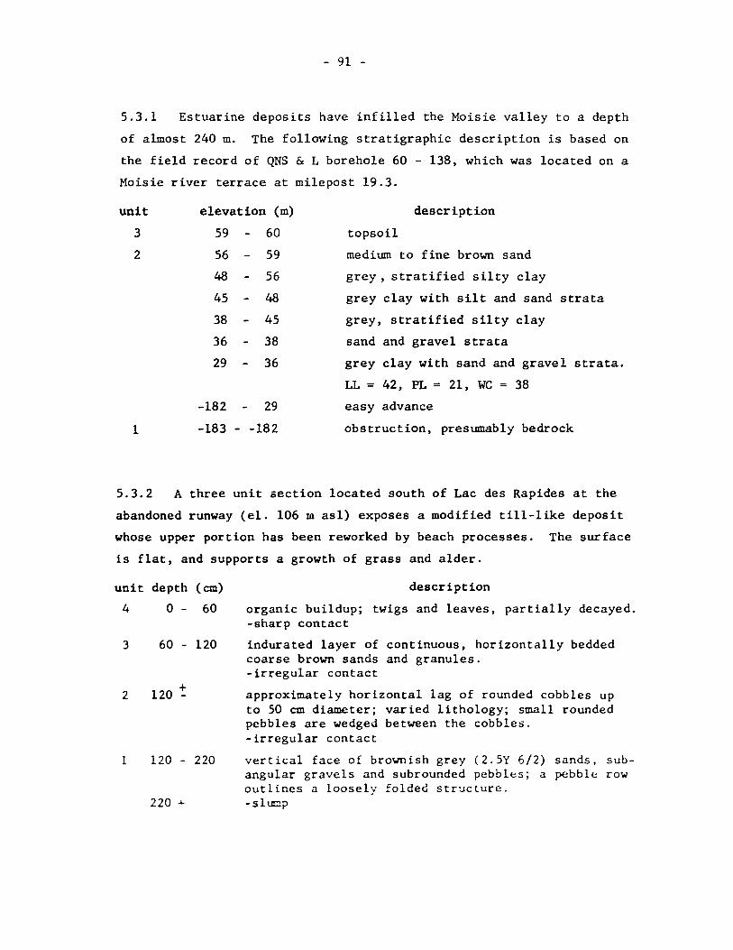
- 91 -
5.3.1 Estuarine deposits have infilled the Moisie valley to a depth
of almost 240 m. The following stratigraphie description is based on
the field record of QNS & L borehole 60 - 138, which was located on a
Moisie river terrace at milepost 19.3.
unit elevation (m) description
3
2
59
56
48
45
38
36
29
-182
60
59
56
48
45
38
36
29
topsoil
medium to fine brown sand
grey, stratified silty clay
grey clay with silt and sand strata
grey, stratified silty clay
sand and grave1 strata
grey clay with sand and grave1 strata.
LL = 42, PL = 21, WC = 38
easy advance
1 -183 - -182 obstruction, presumab1y bedrock
5.3.2 A three unit section 10cated south of Lac des Rapides at the
abandoned runway (el. 106 ID as1) exposes a modified ti11-1ike deposit
whose upper portion has been reworked by beach processes. The surface
is f1at, and supports a growth of grass and a1der.
unit depth (cm)
4 0 60
3 60 - 120
2 120 :
1 120 - 220
220 +
description
organic buildup; twigs and leaves, partially decayed. -sharp contact
indurated layer of continuous, horizontally bedded coarse brown sands and granules. -irregular contact
approximate1y horizontal lag of rounded cobbles up to 50 cm diameter; varied lithology; small rounded pebbles are wedged between the cobbles. -irregular contact
vertical face of brownish grey (2.5Y 6/2) sands, subangular gravels and subrounded pebbles; a pebb1e row out1ines a 100sely folded structure. -sl1.Cp

- 92 -
5.3.3 A three metre section located along the Arnaud Railway immediately
east of Rivière des Rapides iIIustrates the relationship between bedrock,
tili and banded clays. In addition, the preservation of the till remnant
to the east of the bedrock substantiates the theory of an easterly moving
current at the time/elevation that the prograding dunes were developing.
The section is lateral, rather than vertical. The sedimentary
surface is almost fIat (el. 70 m asl) but part of it is boulder strewn
and vegetated by grasses and alders.
unit
4
3
2
l
5.3.4
extent (m)
2~
l~
5
description
planar, erosional, almost horizontal, boulder strewn surface, presumably a water plane. - unconformity
banded grey sands and silty sands dipping gently eastwards. - sharp, regular slanted contact
large subangular granitic boulders in a matrix of contorted yellow-brown (IOYR 4/4) medium sands. -sharp, irregular contact
fine grained, grey-green anorthosite; vertical joints.
Above tlte Moisie meander, point bar deposits overlie fine deltaic
sands and offshore fines. An exposure across the river from the fishing
club documents this sequence.
unit
2
l
elev. (m)
25 - 43
4 - 25
description
discontinuous cross stratified beds of yellowbrown sands, gravels and rounded coubbles; top metre is ironstained and indurated. -sharp contact
shelly, banded sediments; near the base clayey silts in 2 cm continuous horizontal layers alternate with fine sands. elays are wet, gummy, plastic and cohesive. Above, the face is dry and regular; fracture i5 conchoidal.

- 93 -
5.3.5 The gully flow section is located along the left bank of the
lower Moisie river and provides a stratigraphie record of the marine
regression in a deltaic environment. The upper surface of the exposure
is fIat and an extensive peat bog is located to the immediate east.
The record was campiled by B.G. Thom for the Iron Ore Company.
unit
6
5
4
3
2
l
elevation (m)
40 - 41
37 - 40
33 - 37
29 - 33
13 - 29
1-13~3
description
humate, brown sands and gravels up to 15 cm diameter; well-developed cross beds dipping southeast.
cross bedding. -grading into:
horizontally bedded sands and silty sands, in layers 2 to 5 cm thick; loose, slumped .. -sharp contact
grey sand and silty sand, in contorted beds. -grading into:
grey sands, silty sands and sandy siIts; bedding is parallel and dip is 1 to 30 south. Sands are in beds 2 to 5 cm thick, separated by silty beds 5 to 25 cm thick. Where moist, sandy silts have vertical faces; otherwise slumped. Shells were extracted fram silts at 19 m, and wood fram loose sand at 25 m. -undulating eroded contact
grey silts and clayey silts containing intact shells in growth position; poorly bedded horizontal laminae; shells extracted at el. 7 ID.

- 94 -
5.3.6 Along the right bank, near the mouth of the Moisie river a
10 metre section records river-mouth deposits lying unconformably
on low angle deltaic foresets.
unit elevation (m)
3 8.5 - 10
8 8.5
2 7 8
1 2 7
description
continuous beds of medium to coarse brown sands, rounded granules and pebbles; low inclined bedding dipping 20 northeast; indurated. The top metre is podzolized and vegetated with pine and vaccinium. -becoming
grey sand with lenses of granules.
-slumped erosional contact cobble bench
cohesive brown micaceous sands in beds ~ metre thick, dipping southwards at 60 to 450
; separated by fine dry grey micaceous sands in bands 8 cm thick.
5.4 Granulometrie Analyses
field sampling
In the field channel and stratified sampI es were taken
(according to methods in Griffiths, 1967, 12 - 30) so that texturaI
characteristics of the sediments could be examined. Within a unit,
different strata were sampled in order to obtain an estimate of
internaI variation, but the procedure did not include sampling for
variation within a given strat~. The purpose of the sampling was to
indicate what sort of texture was characteristic of an enviro~ent and
not to indicate how one enviro~ent could be differentiated from another
on the basis of texturaI criteria.

- 95 -
On beach ridges samp1es were taken, as far as possible, in
the shoreward flanks so that systematic changes cou1d be recognized.
sieving
The samp1es were air dried and the -25 mm mesh was sieved
according to standard ASTM procedures (ASTM, 1964, 99-106). The fo11ow-
ing sieve co1umn was set up in order to detect ~ma11 changes in the
tai1s of the distribution. During weighing, the 1itho1ogy and
angu1arity contained by each mesh were recorded.
Figure 27 The Sieve Co1umn
opening mm phi
25.40 -4.66
16.00 -4.00
12.70 -3.67
8.00 -3.00
4.76 -2.16
4.00 -2.00
2.00 -1. 00
1.00 0.00
0.50 +1.00
0.25 +2.00
0.177 +2.50
0.125 +3.00
0.088 +3.50
0.074 +3.75
0.063 +4.00
Hydroceter analyses were performed on saoples whi.ch haà more
t han 10", of the sample below 0.074 mm.

- 96 -
statistical parameters
For description, the material was classified according to
the modified Wentworth scale. In addition, several texturaI para-
meters were used, again for descriptive purposes. As mentioned
above, the data can be used to indicate characteristics which are
typical of an environment, but not to distinguish between environ-
ments since:
1) the sampling procedure was not rigid enough to warrant variance
analysis;
2) the smallest sieve unit is ~ phi, which is too coarse to dis-
tinguish slight differences in the extremities of the curves
(Friedman, 1967, 329); and
3) the environmental sensitivity of texturaI parameters is under dis-
pute. Friedman (1961) and Mason and Folk (1958) claim that moments
can be used to differentiate between depositional environments, but
Moila (1968) and Sevon (1966) have found contradictory evidence.
The following paramenters devised by Folk (Folk, 1964, 43-47; 1966,
73-93) were used to describe the central tendency, sorting, and
direction and intensity of the distribution:
mean
standard devietion
ske.Toess
kurtosis
(@16 + ~50 + ~84) 3
(P84 - P16) 4 +
(~95 - ~5) 6.6
(~16 + p84 - 2~50)
2(~84 - ~16)
(~95 - ~5) 2.44 (~75 - ~25)
+ (~5 - ~95 - 2~50)
2(~95 - ~5)

- 97 -
SECTION VI
REFERENCES
Allen, R.J.L. (1965) A Review of the Origin and Characteristics of Recent Alluvial Sedünents, Sedimentology, vol.5, no.2, pp.89-l9l.
Allington, K.R. (1959) The Bogs of Central Labrador-Ungava, McGill Sub-Arctic Research Laboratory, Paper no.7, 89 pp.
American Society for Testing and Materials (1964) Procedures for Testing Soils, Philadelphia, 540 pp.
Andrews, J.T. (1968) Postglacial Rebound in Arctic Canada: Sûnilarity and Prediction of Uplift Curves, Can. J. Earth Sciences, vol. 5, pp. 39-47.
Andrews, J.T. (1970) A Geomorphological Study of Post-Glacial Uplift with Particular Reference ta Arctic Canada, Inst. British Geographers, Special Publication no.2, 156 pp.
Auer, V. (1930) Peat Bogs in Southeastern Canada, GeaI. Surv. Can., Memoir 162, 32 pp.
Bloom, A.L. (1959) Late Pleistocene Changes of Sea Level in Southwestern Maine, Yale Univ., Dept. of Geology, New Haven, Conn.
Bloom, A.L. (1967) Pleistocene Shorelines: A New Test of Isostasy, Bull. GeaI. Soc. Am., vol.78, pp.1477-l494.
Bolton, T.E. and P.K. Lee (1960) Post-Glacial Marine Overlap of Anticosti Island, P.Q., Proc. GeaI. Assac. Can., no.12, pp.67-78.
Bowman, P. (193l) A Study of a Peat Bog Near the Matamek River Quebec Canada by the Method of Pollen Analysis, Ecology, vol.12, pp.694-708.
Brookes, I.A. (1969) Late-Glacial Marine Overlap in Western Newfoundland, Can. J. Earth Sciences, vo1.6, pp. 1.397-1404.
Bryson, R.A. et al. (1969) Radiocarbon Isochrones on the Disintegration of the Laurentide Ice Shl~et, Arctic and Alpine Research, no.l, pp.1-14.
Canada, Department of Agricul ture (1970) The Syste::J of Soil Class ification for Canada, Ottawa, 249 pp.
- 98 -
Canada, Department of Energy, Mines and Resources (1968a) Geol. Surv. Can., Aeromagnetic Series Map no.5039G Sept-Iles, Quebec.
Canada, Department of Energy, Mines and Resources (1968b) Geol. Surv. Can., Aeromagnetic Series Map no.5040G Lac des Rapides, Quebec.
Canada, Hydrographie Service Nautical Charts (1967) Harbour Chart no. 1214 Baie des Sept-Iles, 1:48,000.
Chrosciewicz, Z. (1962) The Significance of Iron Pan Formation on Sandy Sites in Forest Section B7 Quebec, Cano Dept. of Forestry, Forest Research Branch Project H-119, 40 pp.
Drury, W.H. (1956) Bog Flats and Physiographic Provinces in the Upper Kuskokwin River Region, Alaska, Gray Herbarium Contribution no.178, 130 pp.
Faessler, C. (1942a) La Côte Nord du Saint-Laurent de Bersimis à Matamec, Le Naturaliste Canadien, vol.49, pp.39-7l.
Faessler, C. (1942b) Sept-Iles Area, North Shore of St. Lawrence, Saguenay Co., Quebec Bureau of Mines, Div. of Geol. Surveys, Report no.ll with Map no.503.
Faessler, C. (1945) Moisie Area, Saguenay Co., Quebec Bureau of Mines, Div. of Geol. Surveys, Report no.2l, with Map no.600.
Faessler, C. (1948) L'extension Max~um de la Mer Champlain au Nord du St.-Laurent, de Trois-Rivières à ~~isie, Univ. Laval, Contribution no.88, 28 pp.
Farrand, W.R. (1962) Postglacial Uplift in North America, Am. J. Sci., vol.260, pp.18l-199.
Folk, R.L. (1964) Petrology of Sedimentary Rocks, Dept. of Geol., Univ. of Texas, Austin, Texas, 154 pp.
Folk, R.L. (1966) A Review of Grain-Size Parameters, Sedimentology, vol.6, no.2, pp.73-93.
Friedman, G.M. (1961) Distinction between Dune, Beach and River Sands from their TexturaI Characteristics, J. Sed. Petrol., vol.3l, pp.5l4-529.
Friedman, G.~. (1967) Dynamic Process and Statistical Parameters Compared for Size Frequency Distribution of Beach and River Sands, J. Sed. Petrol., vol.37, pp.327-354.

- 99 -
Gadd, N.R. (1960) Surficial Geology of the Bécancour Map-Area Quebec, Geol. Sury. Can., Paper 59-8 and Map 42-1959.
Gadd, N.R. (1964) Moraines in the Appalachian Region of Quebec, Bull. Geol. Soc. Am., vol.75, pp. 1249-1254.
Gauri, K.L. and J. Kalterherberg (1966) Sedimentstructuren aus den Niederrheinischen Braunkhohlenschicten des MiozHns, Sedimentology, vol.6, no.2, pp.115-l33.
Grant, D.R. (1969a) Surficial Deposits, Geomorphic Features and Late Quaternary History of the Terminus of the Northern Peninsula of Newfoundland and Adjacent Quebec-Labrador; MaritÜDe Sediments, vol.5, no.3, pp.123-l25.
Grant, D.R. (1969b) Late Pleistocene Re-advance of Piedmont Glaciers in Western Newfoundland, Maritime SedÜDents, vol.5, no.3, pp.126-l28.
Greig, E.W. (1945) Lake Matamec Map Area Saguenay Co., Quebec Bureau of Mines, Map 602.
Griffiths, J.C. (1967) Scientific Methods in the Analysis of SedÜDents, McGraw-Hill, Toronto, 508 pp.
Henderson, E.P. (1959) A Glacial Study of Central Quebec-Labrador, Geol. Sury. Can., Bull. no.50.
Hind, H.Y. (1864) An Exploration Up the Moisie River to the Edga of the Table-land of the Labrador Peninsula, J. Roy. Geogr. Soc., vol.34, pt.5, pp.82-87.
Kindle, E.M. (1922) Notes on Postglacial Terraces on the Eastern and Western Shores of the Gulf of St. Lawrence, Cano Field Nat., vol.36, pp.111-113.
LaSalle, P. (1966) Geology of the HébertJille Area, çuebec Dept. of Nat. Res., P.R. no.546, 12 pp.
14 LaSalle, P. and J. Rondot (1967) New C Dates from the Lac St. Jean Area, Quebec, Cano J. Esrth Sciences, vol.4, pp.568-571.
Laverdière, C. (1952) Fossiles d'Age Champlainien de la Région de SeptIles, COte Nord du Saint-Laurent, Ann. ACFAS, vol.18, pp.105-107.
Laverdière, C. (1954) La Région de Sept-Iles, Côte ~'ord du Saint-Laurent, Unpublished ~.A. Thesis, U. de ~ontrfal, 194 pp.

- 100 -
Laverdière, C. (1955) Observations Morphologiques Intéressant la Mise
en Place des Sables Ferrifères au Droit de la Côte Nord du Saint-Laurent, Re~Je Cano De géog., vol.9, pp.119-l30.
Lee, H.A. (1962a) Surficial Geology of Rivière du Loup-Trois Pistoles Area, Quebec, Geol. Surv. Can., Paper 61-32.
Lee, H.A. (1962b) Pleistocene Glacial-Marine Relations, Trois Pistoles, Quebec (Abst.) Geol. Soc. Am., Spec. Paper no.73, p.195.
MaeClintock, P. and D.P. Stewart (1965) Pleistocene Geology of the St. Lawrence Lowland, New York State Museum Bulletin, no.394, 152 pp.
MacDonald, B.C. (1969) Surficial Geology of La Patrie-Sherbrooke Area, Quebec, Geol. Surv. Can., Paper 67-52.
McKee, E.D. and G.W. Weir (1953) Terminology for Stratification and Cross-Stratification in Sedimentary Rocks, Bull. Geol. Soc. Am., no.64, pp.38l-390.
MacNeill, R.H. (1969) Some Dates Related to the Dating of the Last Major Ice Sheet in Nova Scotia, Maritime Sediments, vol.5, no.l, p.3.
Mason, C.C. and R.L. Folk (1958) Differentiation of Beach, Dune and Aeolian Flat Environments by Size Analysis, Mustang Island, Texas, J. Sed. Petrol., vol.28, pp.2ll-2l6.
Moila, R.J. and D. Weiser (1968) TexturaI Parameters: An Evaluation, J. Sed. Petrol., vol.38, pp.45-53.
Morrison, A. (1970) Pollen Diagrams fram Interior Labrador, Cano J. Bot., vol.48, no. Il, pp.1957-l975.
Nye, J.F. (1952) A Method of Calculating the Thiekness of Ice Sheets, Nature, vol.169, pp.529-530.
Olsson, 1. and W. Blake (1962) Problems of Radiocarbon Dating of Raised Beaehes based on Experience in Spitsbergen, Norsk Geogr. Tidsskr, vol.18, pp.47-64.
Parry, J.T. (1963) The Laurentians: A Study in Geomorphologieal Development, Unpub. Ph.D. Thesis, MeCill Univ., Montreal, 222 pp.
Parr:, J.T. and J.C. ~cPherson (1964) St. Faustin-St. Narcisse ~oraine and the Champlain Sea, Rev. Ceogr. de ~ontréal, vol.18, no.2, pp.235-248.
Potzger, J.E. (1953) ~ineteen Bogs from Southern Quebec, Cano J. Bot., vol.31, pp.383-401.
- 101 -
Prest, V.K. (1962) Geology of the Tignish Map-Area, Prince County, P.E.I., Geol. Surv. Can., Paper 61-28.
Prest, V.K. (1969) Retreat of Wisconsin and Recent Ice in North America, Geol. Surv. Can., map l257A.
Pryer, R.W.J. and K.B. Woods (1959) Investigation of Banded Sediments Along St. Lawrence North Shore in Quebec, AS TM , STP no.239, pp.55-73.
Quebec, La Commission des Eaux Courantes de Québec de 1947, (1948) Rivière des Rapides, Rapport no.36, pp.lOl-l05.
Quebec, La Commission des Eaux Courantes de Québec de 1950, (1951) Rivière Moisie, Rapport no.39, pp.89-93.
Richardson, J. (1870) On the Geological Examination of the North Shore of the Lower St. Lawrence from the Saguenay River to the Bay of Seven Islands, Geol. Surv. Can., Summary Report of progress 1866-69 pt.7, pp.305-3ll.
Sauvé, P. and P. LaSalle (1968) Notes Sur la Géologie Glaciaire de la Région de Manie 2, Nat. Can., vol.95, no.6, pp.1293-l300.
Sevon, W.D. (1966) Distinction of New Zealand Beach, Dune and River Sands by their Grain Size Distribution Curves, New Zealand J. Geol. and Geophys., vol.9, pp.2l2-223.
Shepard, F.P. (1963) Sea Level Changes in the Past 6000 Yrs: Possible Archaeological Significance, Science, vol.143, pp.574-576.
Stewart, D.P. and P. MacClintock (1969) The Surficial Geology and Pleistocene History of Vermont, Vermont Geol. Surv., Bull. no.3l, 251 pp.
Tanner, V. (1965) Cause and Development of an Ice Age, J. Geol., vol.73, pp.4l3-430.
Terasmae, J. (1969) Quaternary Palynology in Quebec: A Review and Future Prospects, Rev. Geog. de Montréal, vol.23, pp.28l-288.
Weertman, J. (1961) Equilibrium Profile on Ice Caps, J. Glac., vol.3, pp.953-964.
Welsted, j. (1960) The Physiography and Evolution of the Natashquan Terrace, L'npub. M.Sc. Thesis, McGill L'niv., ~'lontreal, 101 pp.
~oods, K.B., R.W.J. Pryer and W.J. Eden (1959) Soil Engineering Proole~s on the Quebec North Shore and Labrador Railway, Roadway and Ballast, Bull. no.549, vol.60, pp.669-686.

- 102 -
Zenkovitch, V.P. (1967) Processes of Coastal Development, Oliver and Boyd, London, 738 pp.