USGS Task Order, Alaska DEM – Phase II Alaska DEM Funding and Implementation Plan

TIN MINING IN ALASKA.
By HENRY M. EAKIN.
INTRODUCTION.
The first discovery of stream tin in Alaska was made by the Geo logical Survey in 1900 on Buhner Creek, in the York district, which occupies the western extremity of Seward Peninsula.1 This discov ery awakened interest in the possibility of finding commercial bodies of tin in this part of Alaska, and in 1901 and 1902 considerable pros pecting for stream tin was carried on in this field. The first com mercial production of tin ore was made in 1902. From that time until 1911, when the first dredge for recovering tin was installed, the placers were worked only on a relatively small scale. Since 1911 the dredge on Buck Creek has operated successfully each season, and in 1914 two dredges were installed on Anikovik Eiver, for the recovery of gold and tin together.
Lode tin was first discovered at Cape Mountain in July, 1902, by W. C. J. Bartels. The following year Arthur J. Collier and Frank L. Hess, of the Geological Survey, found a tin-bearing lode on Lost River, in the eastern part of the York district.2 Lode mining has been carried on to a greater or less extent ever since the first discov ery. The earliest operations were carried on for several years at the Cape Mountain locality, considerable underground development work being done and a few small shipments made. The ground held by the company was then patented, and the property has since been idle. The Lost River mine had been under development in a small way for several years prior to 1913, when the more extensive opera tions under the present management were begun.
Stream tin has also been found in different parts of the Yukon basin on Cleary and other creeks of the Fairbanks district in 1904,8
1 Brooks, A. H., A new occurrence of casslterite in Alaska : Science, new ser., vol. 13, No. 328, p. 593, 1901.
2 Collier, A, J., The tin deposits of the York region, Alaska : U. S. Geol. Survey Bull. 229, p. 23, 1904.
3 Prindle, L. M., A geologic reconnaissance of the Fairbanks quadrangle, Alaska: U. S. Geol. Survey Bull. 525, pp. 81, 90, 1913.
6411° 15 6 ' §1
82 MINERAL RESOURCES OF ALASKA, 1914.
in the Circle 1 and Hot Springs 2 districts, probably, in 1908, and in the Ruby district in 1912.3 There has, however, been no commercial development in any of these fields except in the Hot Springs district.
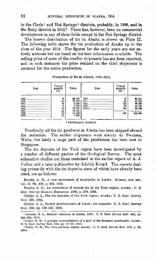
The known distribution of tin in Alaska is shown on Plate II. The following table shows the tin production of Alaska up to the close of the year 1914. The figures for the early years are not en tirely accurate but are based on the best information available. The selling price of some of the smaller shipments has not been reported, and in such instances the price realized on the chief shipments is assumed for the entire production.
Production of tin in Alaska, 1902-1914-
Year.
IQfW1903IQfU1905......................1906......................1907......................1908......................1909.......................
Tons of metallic
tin.
1525146
34OO
2511
Value.
88,00014,0008,0004,000
38,64016,75215, 1807,638
Year.
1910......................1911......................1912......................1913......................1914o.....................
Tons of metallic
tin.
1061
69104
526
Value.
»o o*}c
52,798Qfi fiftft44,10366,560
380,006
« Preliminary estimate.
Practically all the tin produced in Alaska has been shipped abroad for reduction. The earlier shipments went mainly to Swansea, Wales, but lately a large part of the production has been sent to Singapore.
The tin deposits of the York region have been investigated by a number of different parties of the Geological Survey. The most exhaustive studies are those contained in the earlier report of A. J. Collier and a later publication by Adolph Knopf. The reports deal ing primarily with the tin deposits, some of which have already been cited, are as follows:
Brooks, A. H., A new occurrence of cassiterite in Alaska: Science, new ser., vol. 13, No. 328, p. 593, 1001.
Brooks, A. H., An occurrence of stream tin in the York region, Alaska: TJ. S. Geol. Survey Mineral Resources, 1900, p. 270, 1901.
Collier, A. J., Tbe tin deposits of the York region, Alaska: U. S. Geol. Survey Bull. 229, 1904.
Collier, A. J., Recent developments of Alaska tin deposits: U. S. Geol. Survey Bull. 259, pp. 120-127, 1905.
1 Johnson, B. L., Mineral resources of Alaska, 1909 :.U. S. Geol. Survey Bull. 442, pp. 246-250, 1910.
2 Bakin, II. M., A geologic reconnaissance of a part of the Rampart quadrangle, Alaska: U. S. Geol. Survey Bull. 535, pp. 37-38, 1913.
3 Eakin, H. M., The Iditarod-Ruby region, Alaska: U. S. Geol. Survey Bull. 578, p. 29, 1914.

U . S. GEOLOGICAL SURVEY BULLETIN 622 PLATE II
Locality wheresome tin has been
found
SKETCH MAP SHOWING DISTRIBUTION OF TIN IN ALASKA.
TIN MINING IN ALASKA. 83
Hess, F. L., The York tin region: U. S. Geol. Survey Bull. 284, pp. 145-157, 1906.
Knopf, Adolph, Geology of the Seward Peninsula tin deposits, Alaska: U. S. Geol. Survey Bull. 358, 1908.
Hess, F. L., Mineral resources of Alaska, 1911: U. S. Geol. Survey Bull. 520, pp. 89-92, 1912.
The following publications deal mainly with more general geologic topics, but contain incidental references to the occurrence of tin in Alaska:
Brooks, A. H., A reconnaissance of the Cape Nome and adjacent gold fields of Seward Peninsula, Alaska: U. S. Geol. Survey Special Pub., pp. 132-139,1901.
Collier, A. J., A reconnaissance of the northwestern part of Seward Penin sula, Alaska: U. S. Geol. Survey Prof. Paper 2, pp. 49-51, 1902.
Johnson, B. L., Mineral resources of Alaska, 1909: U. S. Geol. Survey Bull. 442, pp. 246-250, 1910.
Prindle, L. M., A geologic reconnaissance of the Fairbanks quadrangle,Alaska: U. S. Geol. Survey Bull. 525, pp. 81-90, 1913.
Eakin, H. M., A geologic reconnaissance of a part of the Rampart quadrangle, Alaska: U. S. Geol. Survey Bull. 535, pp. 37-38, 1913.
Eakin, H. M., The Iditarod-Ruby region, Alaska: U. S. Geol. Survey Bull. 578, p. 29, 1914.
The growing importance of the tin-mining industry in Alaska led to a reexamination of part of the York district in 1914, and to a sim ilar investigation of the tin deposits of the Hot Springs district. Only a brief time could be devoted to the work, and this paper is, therefore, by no means an exhaustive discussion, even of the deposits which were examined. Much of the material here presented has been compiled from the reports listed above.
The writer desires to acknowledge the^courteous hospitality shown to him by the residents of the districts visited, and the assistance in collecting data generally lent by the operators. Special acknowl edgment is due to Mr. George Jamme, of Lost River and Seattle; Mr. Walter Johnson, of San Francisco; and Mr. Sylvester How ell, of Tofty.
TORK REGION.
Tin ore in both lode and placer form is broadly distributed in the western part of Seward Peninsula, but commercial development has taken place at only a few localities. (See PI. III.) Lode properties have been prospected at Ear Mountain, Buck Creek, Cape Mountain, Brooks Mountain, Lost River, and a few other localities of minor importance, but the only productive lode mine at present is that of Lost River. Considerable underground work has been done on the Cape Mountain property, but as the mine has been closed for several years it was not examined by the writer. Placer tin has been pro duced in commercial quantities from Buck Creek and from Anikovik

84 MINERAL RESOURCES OF ALASKA, 1914.
and Lost rivers. Placer operations in 1914 were confined to Buck Creek and Anikovik Kiver.
The mining activities of the region in 1914 included the operation of three dredges for all or a part of the season, the preparation of a tract of tin placer ground for the installation of an additional dredge, and the operation of the Lost River lode mine and mill. About 40 men were engaged directly in mining operations 20 men on Buck Creek, 5 on Lost Eiver, and 15 on Anikovik River, where two dredges operated for both tin and gold. About 25 men were also employed temporarily in the construction of the new dredge on Anikovik River, The only winter mining done in the district is at the Lost River mine, where 3 men are employed.
LOST RIVER MINE.
GEOGRAPHY.
Lost River is a small stream that heads in the York Mountains and flows southward into Bering Sea about 10 miles east of Cape York. The mine is located in the valley of Cassiterite Creek, which joins Lost River from the east about 6 miles from the coast. An excellent wagon road leads from the coast to the mine over easy grades.
The waters at the mouth of Lost River are generally icebound from early in November to the last of May. During the other five months of the year they afford a port for shipping similar to that of Nome. Landing is hindered only by southerly or westerly storms, and at such times a safe anchorage is to be had in Port Clarence, 25 miles to the east. As a rule, these storms are not long. Freight charges from Seattle, including lighterage at Lost River, on ordinary mer chandise are $12.50 a ton (1914). The return charge on ore is $15 a ton (1914).
GENERAL GEOLOGY.
The general geologic features of the Lost River region have been summarized by Knopf 1 as follows:
The general geologic features of the region are simple. The bedrock consists of the Port Clarence limestone, dipping northward at an angle of 20°. Near the head of Cassiterite Creek the limestone is intimately banded with argilla ceous lamina? and intensely crumpled. Locally, the formation is fractured and brecciated, and shear zones of white marble have been formed.
On Tin Creek, another tributary of Lost River, a small granite boss a third of a mile in diameter is intruded into the limestone. The granite is a medium- grained aggregate of feldspar, quartz (which is partly idiomorphic, smoky, and conspicuous), and scattered foils of biotite. The principal effect of this intru-
1 Knopf, Adolph, Geology of the Seward Peninsula tin deposits, Alaska: U. S. Geol. Survey Bull. 358, p. 43, 1908.

TIN MINING IN ALASKA. 85
sion has been to marmarize the surrounding limestone, though locally some large masses of contact-metamorphic minerals have been formed.
A considerable number of vertical quartz porphyry dikes pierce the limestone, but only one has been found extending into the granite area. They are fairly persistent and can be traced for several miles across the country. They are not all strictly contemporaneous intrusions, as certain dikes have been found to intersect each other. The quartz porphyries are light-colored rocks con taining small glassy quartz and feldspar crystals embedded in an aphanitic matrix.
A few of the quartz porphyry dikes are highly altered and con tain more or less of tin and tungsten minerals. Two dikes of this character, known as the Cassiterite and Ida Bell lodes, are being developed by the Jamme syndicate as the Lost River mine.
CASSITERITE LODE.
The general character and mineralogy of the Cassiterite lode have been described by Knopf l as follows:
. The principal tin prospects of the region are located on Cassiterite Creek and occur in the quartz porphyry dike known as the Gassiterite lode. This dike is 6 to 10 feet thick and can be traced from the head of Tin Creek in a northwesterly direction to Lost River, a distance of 9,000 feet. Near Lost River the dike rock contains a multitude of angular limestone fragments and is really a limestone breccia cemented by quartz porphyry. The characteristic feature of the Cassiterite lode dike rock, where nonstanniferous, is the abun dance of sharply denned quartz phenocrysts embedded in a white aphanitic matrix. Thin sections cut from the least-altered portions of the dike show numerous phenocrysts of quartz, orthoclase, and sodic plagioclase embedded in a cryptocrystalline groundmass. The nonlamellated feldspar is opaque from kaolinization, but the plagioclase is unaltered.
Sporadic crystals of clear and limpid plagioclase lie inclosed in turbid ortho clase phenocrysts. Fluorite is common in the groundmass, and patches ot topaz occur also. More highly altered phases of the dike merely show quartz phenocrysts lying scattered in a matrix of scaly white mica, fluorite, and quartz. Along a portion of its course the white quartz porphyry dike has broken through an older dike, a gray feldspar porphyry, which is particularly con spicuous on account of the multitude of dull-white phenocrysts that it contains.
The tin-bearing portion of the dike is 3,000 feet long, but the whole of this length can not be considered ore rock; intermittent barren stretches occur, and the ore is probably localized in irregular shoots. The limestone in the vicinity of the stanniferous portion of the dike is seamed with innumerable veirilets which reticulate the surface of the country rock in every conceivable direction. These vary in thickness from a film's breadth to several inches. An energetic metasomatic alteration has accompanied the [formation of the] veinlets, and cassiterite is locally observed in them, but nothing in the nature of a stanniferous stockwork has been formed.
The tin ore found in the quartz porphyry dike is associated with irregular seams and stringers of quartz and lithia mica. Cassiterite occurs both in the stringers and as an impregnation of the altered dike adjoining the stringers. Where the veinlets are absent the quartz porphyry contains no cassiterite and is hard and barren. Wolframite is commonly associated with the cassiterite,
1 Knopf, Adolph, op. cit, pp. 49-50.

86 MINERAL RESOURCES OF ALASKA, 1914.
and, though no actual tests have been made, it is probable that the tungsten content of the lode is as valuable as the tin. Pyrite and arsenopyrite accom pany the tin ore, and more rarely sphalerite and galena are found. Locally the dike rock contains some molybdenite. The commonest gangue mineral is fluorite, with zinnwaldite next in order of abundance. Thin sections show also the presence of topaz in radial aggregates. Where alteration has been most intense large drusy masses of cubical fluorite and mica occur, and from such localities magnificent specimens of cassiterite in black splendent crystals have been obtained. The usual type of ore, however, is a soft kaolinized porphyry, stained red with iron oxide and impregnated with cassiterite, wolframite, and sulphides. The dike is intensely and irregularly slickensided, and clay gouge is common. The limestone wall rock, however, is firm and hard. It is con siderably impregnated with fluorite, which glows with a greenish light when
struck with the pick. Thin sections of wall rock immediately adjacent to the dike show that it consists of fluorite and radial topaz, with some colorless mica. Cassiterite occurs to a small extent in the wall rock in narrow veinlets, 1 inch thick, consisting of divergent columnar topaz. In the vicinity, of these veinlets the fluoritized limestone contains patches of coarse fluorspar and rosettes of topaz.
Since 1907 additional development has delineated the form of the Cassiterite lode to better advantage. The maximum width devel-
FIGDKB 2. Longitudinal section on Cassiterite lode, showing surface profile and under ground developments.
oped is 23 feet, and the average width is estimated at 12 feet, from the evidence afforded by numerous crosscuts along about 1,100 feet of drifts. The extreme limits of development work embrace a hori zontal distance of 1,420 feet and a vertical distance of 410 feet above the creek bottom. The indications point to the persistence of the lode in form and character below the creek level, and no special mining difficulties at depth are indicated.
Some strong veins carrying tin crop out 300 feet north of the Cassiterite lode and dip 45° S. The lode itself dips 85° in the same direction, and if these dips persist the veins should meet the lode at a depth of about 300 feet below the creek level.
Developments on the Cassiterite lode in July, 1914, consisted of 1,094 feet of drifts on five levels, besides a number of crosscuts, and an upraise of 108 feet between the first and second levels east, as illustrated in figure 2.

TIN MINING IN ALASKA. 87
About 2,000 tons of ore taken from the first and second levels east lies on the dump at the portal of the lower adit.
The test mill of the Lost River mine plant has operated for two successive seasons. The dump, containing about 2,000 tons of run-of- mine ore, was sampled by trenching entirely across its center and milling all the ore as it came. The results of the test probably indi cate very closely the general tenor of the dump as a whole and of a large body of minable ore blocked out by the developments indicated.
The managers report that about 4 per cent of concentrates were obtained from the ore milled during the two seasons and that no notable variation was observable at any period of operation. The concentrates are very clean and are said to contain an average of 62.81 per cent of metallic tin and 11.08 per cent of metallic tungsten.
IDA BELL LODE.
The Ida Bell lode strikes northeast and intersects the Cassiterite lode at the surface 700 feet west of the creek and 225 feet above creek level. Its dip is approximately 90°. It is wider than the Cassiterite lode, ranging from 25 to 35 feet. Developments on this lode include a 70-foot adit and a 60-foot winze sunk at its extremity.
Like the Cassiterite lode, the Ida Bell is a quartz porphyry dike, but the pronounced alteration of the former is not here duplicated. For the most part the lode consists of firm, slightly altered quartz porphyry intricately traversed by thin, rich veinlets with Cassiterite as the only conspicuous valuable mineral. The ore is reported to be of good quality, but owing to its hardness it will require different treatment from that adapted to the Cassiterite lode ores, which are soft. Further development of this part of the mine will await a higher development of the reduction plant. .
EQUIPMENT.
The general equipment of the Lost River property includes a small warehouse at the mouth of Lost River; quarters, stable, blacksmith shop, etc., at the mine; a small reduction plant, also at the mine; and the mine equipment. A good limestone road leads from the mine to the beach over easy grades, and with but slight improvement it would be suited for heavy haulage by tractor or team. At present a team and wagon furnish transportation to and from the mine.
Considerable ingenuity has been shown in developing efficient methods of reduction suited to the ores of the Cassiterite lode. Being soft the ores are easily crushed, but an abundance of clay complicates the process of washing.

The ore is first passed through a 6 by 7 inch Dodge crusher, from which it is delivered to a revolving launder that resembles a concrete mixer. From the launder the fine ore is delivered directly to a gyra tory mill, and the coarse material is passed through a 3 by 4 inch Case crusher and then goes to the gyratory mill. The crushed ore from the gyratory mill is delivered to an 18 by 60 inch slug mill, from which it passes to a standard Monarch table. The table separates the material into three grades concentrates, middlings, and tailings. The middlings are returned to the slug mill to be reworked.
The capacity of the plant is 5 tons of ore in 24 hours. Gasoline engines developing 15 horsepower furnish the motive power.
The climate renders it impossible to operate the reduction plant for more than half of the year, but mining is possible at all seasons. The reduction plant has been operated mainly for experimental purposes in developing reduction methods and testing ore for only small parts of the available seasons. The region is barren of timber, so that all fuel, lumber, and mine timbers must be shipped from the States or from other parts of Alaska.
The low grade of the ores mined on Lost River (see p. 87) makes them available only for cheap methods of mining and milling. The ores are easily mined, owing to their softness, which permits the use of augers in preparing holes for blasting. Efficient methods of re duction have been developed, but owing to the small size of the plant the treatment is expensive. It is proposed to replace the test mill by one similar in plan but having a daily capacity of 100 tons of ore.
As methods of reducing the ore have been under investigation each summer at the Lost River plant, methods of recovering the metallic contents of the concentrates have been investigated in winter in Seattle by the same persons. Mr. George Jamme reports the suc cessful separation of tin and tungsten minerals from the concen trates and the successful smelting and refining of metallic tin from the separated ore. Analysis of the refined tin obtained in the Seattle laboratory gave the following result:
Per cent.Tin ____________________________________ 99.63 Iron _________________________________ .07 Titanium _______________________________ .14 Sulphur _______________________________None. Undetermined, probably silver__________________ .16
As progress is gained in mining and reducing the ores in Alaska, it is proposed also to expand from the experimental laboratory to a practical smelter for reducing the concentrates, a service that is not now to be had satisfactorily in the United States.

TIN MINING IN ALASKA. 89
LODE PROSPECTS.
A large number of lode prospects are held in western Seward Peninsula in the localities named earlier in this report. Most of these prospects have been described by .Knopf-1 Those not operated in 1914 were not examined by the writer and will not receive further attention in the present paper.
The only active tin lode prospecting in this part of the field in 1914 was done in the vicinity of Potato Mountain, at the head of Buck Creek, where several lode claims are held. Only the annual assessment work was done, and nothing new is reported as to the character of the deposits or their promise of economic development.
Much interest has been shown for several years by tin-lode pros pectors in the Ear Mountain region, 40 miles northeast of the York district. A large number of properties have been located and devel opment work is in progress on some of them. According to current reports, this section of the tin-bearing region promises the early development of several productive lode mines.
TIN PLACERS.
Placer tin has been produced from Buck Creek and tributaries, from Anikovik River, and from Cassiterite Creek at the locality of the present lode mine. Buck Creek has been productive since 1902. Anikovik Eiver made its first important production in 1914, when two dredges were operated for the recovery of both tin and placer gold. The Cassiterite Creek tin placers were of small extent and were exhausted soon after their discovery, having produced about 20 tons of concentrates.
BUCK CKEEK AREA.
GENERAL FEATURES.
Placer tin occurs on Buck Creek for its entire length, about 4 miles, and on Sutter Creek and Left Fork, its principal tributaries. The gravels of Grouse Creek are tin bearing for over a quarter of a mile below the mouth of Buck Creek.
Developments have shown the presence of tin in profitable amounts along the greater length of Buck Creek, in the lower parts of Left Fork and Sutter Creek, and for a considerable distance along Grouse Creek below the mouth of Buck Creek. Actual mining has taken place only on Buck Creek and tributaries.
Knopf 2 has shown that" Cassiterite occurs in bedrock in three ways in the Buck Creek area (1) as an impregnation in quartz porphyry
1 Enopf, Adolph, Geology of the Seward Peninsula tin deposits, Alaska: U. S. Geol. Survey Bull. 358, 1908.
"Idem, p. 33.

90 MINERAL RESOURCES OP ALASKA, 1914.
dikes, (2) in quartz stringers cutting the slates, and (3) intergrown with arsenopyrite in a gangue of radial actinolite." He ascribes the chief source of the stream tin to the abundant quartz stringers of the Buck Creek area, this being supplemented somewhat by the other forms of bedrock deposits.
Apparently the zone of bedrock that contributed the major portion of the placer tin does not reach eastward to the mouth of Buck Creek. Angular pieces of cassiterite and slightly worn crystals, in dicating local derivation, are abundant in the placers only above the vicinity of Sutter Creek. Downstream the stream tin is more and more thoroughly worn; it grades into finer average particles and the placers contain increasing relative amounts of iron minerals.
The erosional history of the Buck Creek area is complicated by an earlier cycle of marine erosion, when broad sea terraces were developed over almost its entire extent, and a later cycle of stream erosion, during which the present depressions were formed. An uplift of the general land mass of about 600 feet intervened between the two cycles. Some concentration of stream tin was effected during the earlier cycle on the surface now represented by the York Plateau, remnants of which occur in the uplands near Potato Mountain, 600 feet above sea level, and elsewhere at about the same elevation. The stream erosion of the later cycle reconcentrated the placers of the old plateau gravels and derived additional concentrates from the bedrock eroded from below this level. The high-level gravels of the plateau surface persist only in small areas about the heads of Buck and Sutter creeks. As they have not been prospected, little can be safely inferred as to their possible value. Direct reconcentrations from them in the gravels of slightly incised headwater streams of Buck and Sutter creeks have been tested and found of high value. Considerable amounts of concentrates are reported to have been ob tained from the head of Peluk Creek, and other rich concentrations are reported from similarly situated .streams. The worn condi tion of the concentrates is out of harmony with the slight erosion effected by the creeks from which they were taken, and it seems clear that they represent reconcentrations from the older beach de posits of the plateau surface. The richness of the reconcentrations suggests the possible occurrence of commercial deposits in the plateau gravels.
The downcutting of the streams toward their present positions has apparently I een more or less intermittent, and during periods of relative stability the valleys were broadened and the stream courses changed to some extent. The streams that changed their courses failed to carry the concentrations down to lower levels, and local bench placers resulted. Such deposits are reported to occur on

U. S. GEOLOGICAL SURVEY BULLETIN 622 PLATE III
MAP OF YORK TIN REGION, SEWARD PENINSULA, ALASKA.

TIN MINING IN ALASKA. 91
Sutter and Grouse creeks, but so far they have not been developed commercially.
DEVELOPED PLACERS.
Commercial tin placers have been developed for about 3f miles along Buck Creek and for over a quarter of a mile on Grouse Creek below the mouth of Buck Creek. The development work includes prospecting with the drill, open-cut mining, and dredging. About 1| miles of the placer ground had been mined out at the close of the season of 1914.
The average depth to bedrock on upper Buck Creek is only 4 feet. Downstream the depth increases slightly, and at the mouth of Sutter Creek and below it is 5 to 6 feet. The width of the placer is 60 to 200 feet. In the upper section the average width is about .100 feet; downstream it is somewhat greater.
The concentrates derived from placer operations contain cassit- erite, sundry heavy iron minerals, and a little gold. The average metallic tin content of the concentrates is reported to be about 60 per cent. The tenor is higher upstream and lower downstream, where the iron minerals are relatively more abundant. The gold content is worth only a few dollars a ton, and so far it has not affected the selling price of the product.
OPERATIONS IN 1914.
The only mining operations carried on in the Buck Creek area in 1914 were dredging and preparation of ground for dredging.
The York Dredging Co. operated from July 16 to the end of the season, beginning 1,500 feet below the mouth of Sutter Creek and working downstream. A length of about 6,500 feet above this point had already been dredged. The dredge was built by the Union Construction Co., has open connected buckets holding 2f cubic feet, and develops 100 horsepower with distillate engines. Its estimated daily capacity is 800 cubic yards. It was found practical for work ing only the placers below claim No. 19, where the gravel is over 4 feet deep.
About 1| miles of placer ground above claim No. 19, owned by the American Tin Co., of San Francisco, was prepared for dredging during the summer. The ground was stripped of muck and vegeta tion, and drains were cut so that the frozen gravels would be thawed. A shallow-draft dredge will be required to operate in this section of the Buck Creek placers.
ANIKOVIK RIVER.
Placer gold and tin have long been known to occur in the gravels of Anikovik River, but all the early attempts at exploitation by

92 MINERAL RESOURCES OF ALASKA, 1914.
the relatively expensive manual methods proved unprofitable. In 1914 the American Gold Dredging Co. put two dredges into opera tion on the lower Anikovik, having tested the ground by drilling the previous year. One of the dredges, formerly on Peluk Creek near Nome, was towed along the coast of Bering Sea intact and was made to dig its own way across the bar into the mouth of the river. It was then shut down for remodeling. The other dredge was new and was installed on an artificial pond a quarter of a mile from the beach. It was completed August 1 and operated continuously for 65 days during the remainder of the open season.
The Anikovik Kiver placers are shallow, ranging generally be tween 6 and 8 feet in depth. Their materials are chiefly coarse river gravels and cobbles. The bedrock is slate, and locally its surface is uneven, coming close to the surface of the gravels and adding to the difficulties of operation. However, the success of the dredging oper ations during the season of 1914, when some of the worst "reefs" were encountered, indicates that this condition of the bedrock sur face constitutes no fatal obstacle to the undertaking. The chief value of the placers is in their gold content, but sufficient tin is present in them to make a valuable by-product.
The bedrock source of the tin and the history of its concentration in the river placers are probably essentially similar to those of the Buck Creek deposits.
HOT SPRINGS DISTRICT.
GENERAL FEATURES.
Placer tin accompanying placer gold was discovered on Sullivan Creek, in the Hot Springs district, probably in 1908. Gold mining in the district developed rapidly, and as the productive area in the vicinity of Tofty increased it was found that tin and gold were generally associated and that the richer concentrations of the two minerals were generally coincident.
In the earlier mine development no attempt was made to save the tin ore, and as it blocked the riffles and added to the difficulties of saving the gold it was regarded only as a nuisance. During clean-ups more or less of tin concentrates were thrown aside, and the accumula tions at the mines were disregarded until 1911, when 1,200 pounds were collected and shipped. The ore was found to be of high quality, and the returns from the small shipment directed attention for the first time to the possible value of tin as a by-product. In 1912 some of the mines made an effort to save more of the concentrates, and 20 tons were shipped. The technique of sluicing for the recovery of tin and gold has been improved, and in 1914 about 48 tons of

TIN MINING IN ALASKA. . 93
concentrates were produced, despite the fact that many operators, including some of the largest, made no recovery. The total waste of tin ore in the tailings of the mines of the district probably amounts to hundreds of tons. With mining operations continuing at their present magnitude the production of tin ore could be greatly in creased perhaps doubled without additional expense except for the more elaborate system of sluicing required.
The freight rate on tin ore from Hot Springs to Seattle is not definitely known, but it probably does not exceed $55 a ton, which is the tariff on ordinary merchandise (1914). The rates on ship ments from Seattle to Singapore in 1914 were approximately $15 a ton.
GEOLOGY.
The known area of occurrence of cassiterite in the Hot Springs district coincides in general with that of the productive gold placers of the Sullivan Creek basin. The general placer zone is about half a mile in maximum width and extends for about 6 miles from upper Cache Creek to Woodchopper Creek. Within this zone are numerous small areas of concentration, as described elsewhere in this volume in connection with the Hot Springs gold placers.
The country rock of the tin-bearing area, as described in an earlier report by the writer,1 is composed of a series of slates, quartzites, and schists, probably of Mesozoic age. Granitic intrusive rocks occupy two small areas in the same general region, one forming Roughtop Mountain, at the northeastern headwaters of Sullivan Creek, and the other Hot Springs Mountain, at the southeastern headwaters.
The bedded rocks of the area have been strongly metamorphosed. They contain numerous small quartz lenses and stringers and quartz veins that are 20 feet in maximum width. The larger quartz veins where examined are apparently barren of valuable mineralization, but some of the smaller stringers are gold bearing. Gold nuggets more than half quartz are found in some of the placers.
No direct evidence has been discovered as to the form in which the cassiterite occurs in bedrock. Some nuggets appear to have been de rived from quartz veins that had been brecciated and recemented with cassiterite; others contain little besides the pure tin mineral. The cassiterite of the placers has been derived from a local source, as is shown by the large size and angularity of some pieces of the ore, and it seems likely that the bedrock source has been in the veins and stringers that cut the metamprphic bedded rocks of the immediate vicinity of the placers.
1 Eakin, H. M., A geologic reconnaissance of a part of the Rampart quadrangle, Alaska : U. S. Geol. Survey Bull. 535, pp. 20-21, 1913.

94 . MINERAL RESOURCES OF ALASKA, 1914.
PROSPECTING FOB LODE TIN.
The local derivation of the tin ore should be emphasized, on ac count of the belief current in some quarters that the material of the placers has come from the vicinity of Roughtop Mountain, a belief that has led to much apparently useless prospecting for lode deposits at that locality. The so-called prospects near Roughtop Mountain were examined by the writer in August, 1914, and samples purport ing to be high-grade ore were taken. These samples have since been tested chemically for tin, and no trace of the metal was found. The prospect pits are sunk on what appears to be the ordinary country rock in a more highly altered phase near its contact with the intrusive granite. Nothing resembling the tin ore of the placers was found, nor anything that suggested the presence of cassiterite in any other form.
Those interested in prospecting for tin lodes that might have sup plied the material of the placers should look to the bedrock in the vicinity of the placers, especially of the placers that contain many angular, slightly worn ore fragments. It seems certain that this bed rock source of much of the tin is to be found between Sullivan Creek and the north margin of its drainage basin west of Quartz Creek. Whether lodes of commercial value occur in this area, can be deter mined only by an examination of the bedrock, a difficult and expen sive matter except in the mine workings or along the ridge tops, because of the thick accumulations of alluvium and rock waste.