Working Towards an Ecosystem Service Valuation Standardization Pamela Kaval.

UNITED STATESDEPARTMENT OF THE INTERIOR
GEOLOGICAL SURVEY
H&G8SS3 H2PG8S OH SEPTET
THS pom: SSCT B&&VL B&ssf TSTOIU coarrr,
?#
Pxvparod at tho yoqotovt of tht fittroau of Yards and Docks,
of tfa* Sovjr
13CO

jjrouiil1 <flj1j8r ^yr^l^fUffTff bGmoatji tbo
S
Pttrpooa oT report *» * ** * 3
Azoa of sto^jr « * * «» * * » 4
Other l&9*8ti &tlOQ8 «« *» « * 5
Scope of work t$r tbi Gtodogtcal Sonogr 7
Ctaard Plain * * « 10
rasturea * » IX)
»*»** » « 13
Quality of water «»*« «» « « «« 17
flald at Point £031 Sacral Base * * * « 20
2io2d at Port HQaDBm 3iml BGUMI « « 25
of oooan-Koter izrtrualoa * * ** » 25
Port Hp/fT^fflff * »* »* 26* * »» ** 20
SOOTOM of aiWtitnral water nppl^ 52
of
Qrtablial8«nt of oboorvatiaa woUa mor the ooost* 28
prognan of tho Godlagteal Stmreor » 40
nolntton fop a &r* sap&y * ** 42
tft »* » » * * » * 44
^ \ t"T~ i'jt | f I ^ *^ ..... l F: » si»... 9 . » i j . . 1. . .tfA
JOIsstattUora at arsd of s-ap
1* li*p of coastal port of Tontura County, California^ shoving Point Ifega and Bert f&m«r» Mawil
2« !&p of QKnrd Hlaln, Vontana County, CaliXcmfa,of
4« TSfcter-fcable contoora, spring 2J9^0 Qmn Corfeling)
5* Ifotpogapfag for four mils on tho Qiaard Plain
profHas acroea Ctoard
7« H^trograpbs for soL^ctei iwlla at Port SoaaaaK I^val Base 1948
Figaro 1* ChlarLio content of waters j^tn s»l9ctcd Trails at Bart
2* ChloricSo content for thro« tatlln cosataard £pcm Fort
HtQCSESS 8STORT OS 3AES SUPPU FCB
THS poOT-zio&zj :u7At BASS, TEHEE* coom?rf
A* Garratt* and
3STRQDUCTXC8
Iterposa of raport
At tba raquaart of tha Bureau of l&rda and Daeks of tte !&V7 Daport-
aantt tba U« 3* Geological 3ur?*y in mklrtg an Inroatl^ation of tba
tBidcrsraand tmter reaoureaa of tha tiaval Air UJaolla Tbot Center at
Bfttnt ^oca9 Ventirra Coonty, California^ Tba study vaa roquaatcd with
apedal rofareoce to tba Gswy'a p^»r>^ oxprjanalan of this center and tba
of about
2h ita initiating reqoostt tba Bureau of *Sxrda and Docks Incilratod tbat
baoaoaa of tha ooxrent TOotiiB'iifflT of sroond-<»tor l/enrola, tbaro appears to** -*.^-
ba a aariooa poaalbHHqr of aaltHaa&er Itwaolcn §st» tba wall £ laid at tha
Point ttsea lawal Cto««jdLt
Tbta progreaa report atsaarizaa tha factual data-nhich hsro been
eol2aetadt iralnrtoii a Irlaf atataaant of gaologte and l^drologls eondltlocsa
banaath tba Canard Plala, and arBraarlaoa tba praeaot laxxAa&sys with roapact
to poaaihla aaa-otpr imnalon near tba Point a^ca and Port nuonrao Usral
Baaaa* It <Hacuaaaa briafly tba aewral poga1.M1tt.1ea for obtaining tba
raqulrad supply of water and auegaata davolopBent of a temporary aupply at

the Point Ife^a 8amL Baae« Also, it outlines oertaln additional work by
the Geological Sarwy to ereaOaate possibilities for dewlopoent of cfeeper
aquifers and to obtain field data relating to oeean-wter Intrusion*
area of stuoy
the Point Sfc^i Base occupies an area of about 4 square alias at tho
sooth ed0a of the Qrnard Slain, the coastal plain of Ttotcra Count/ (see
pi* 1)« The Qxnard Plain borders the nxoifljc Ocean, has a length of about
IS nilc* extending northwestnard £rca Point Uc^u to the city of Vsntara,
and an ovsraoo width of 20 miXos« It is traversed by th> Santa Qara lilTsr
OB the north and by a sruch «M*^«<* atreaa, Callsgoaa Cnsk, on the south*
Da the north, east, and sooth, the Qcnard &ain Is bounded by hjgftftand areas,
for the Host part composed of rxrc-watar-fcearlng fosRRatioos* The
are aepavated by tongoes of allovlxra wfaioh extend trttarrt l^on the plAln and
conprlae the Santa IfeuLa, tas Boeas, end Floaeant Valley Basinai (pi* !}
Santa Buzla Basin is separated rron the Ox&avd ftain 07 a grouni-^atar
the divisions between the southern two basins and the Oznard Hala
are soaewhat attltnary, oeavucpopdlng rousfely with the aooths of the
About 7 mDLes northwest along the ooast ton Ibint 2asa is tho Karoal
CooBtructlon battalion Orator at Fort Hoanane* The water supply for this
is taken Crcm well*. Bmuee the draft frm this well field bas
substantially slno* the «ar, it bas been sue£B0tod that
water soppily for the eKjantW Badnt Hoga Eatml Base nl^t bo obtained by
ponping so^oallsd IsurptasX «at«r froo these wnlis and transporting It
tfarocgh a pipe line to Pdint fioga* Thos, the inbsertty of the
aupply at thi ifert Hcenane Base also is an tsstae in this
of the condition joat autliz»d, on ix&estigatisn rolatiag
the mtar suply for the Ibint ifega Qewal Base
liuoir wlth^jhe G»olos7 and gpoaad*«at0r conditions
benaath th§ Cbomrd Plain as a wbofllo*
1. tba first interfflivw ixwcstl^aticn of tte water reocwrcea of
Coontgr «aa carrlad on by the California BtTialon of Hiter HssourcoulOto 1052 and assultad in two iDhiimt.innrftfe; Tbla atuiy was prisartty
, Ventura County amoti^tiAnt California Public $torks, TJKtor lto<mraaft DiT«, Boll» 48, 244 pp., 1S53«
Comty ^awaatlgation> Basijs data for the period 1327«« >to 1252, indoairot CallfomiA Dapt. Mallo ^orka, ^atar Basourees Q!T.,
40-4f 574 '
an aittlnatlQn of water reaouroaa, both 9or£abaa and ground waters, fcr tht
oafcis* counter* Althoc^x a largo Sfiiiattof data «er« eollaotad on «at«r
lanntla in walls and on qnallty of croond waters, tba eaolosr of tba watar-
baarlag dapoalts mua not atudiad in any dotaiJU
Z, After compaction of thla iaBMtttgattan in 1252, tar. H. H* Jtadaon,
who ted bean in otsarga of ftald operatlm for the Dlvisixn at mtor
vaja aBplc^pd by ^nxtcm Ccnnty to oontlnoa the sunnsy of wfttcp
. Frca 19S2 to dato, UP. Jaadscnf» ctftloe baa obtained ocotiming
data on atreaa flor and on wrter law»la in walla, t^lthin the award Jlain,
for aaoBip£La, parlodio «MMRaniinanta bvm been aada about S tiwa a year for
about 150 well» and plotting of bydroarapha fcr theaa walla ia bipt tip^o*
date* 2^. Jasxiaon'a office baa collected a lev wall log* bat bas not bad

tha foada to sake az^r interpreti'Tie studies of the sround^iater conditions,
nor to carry on aoor cooctijaaiss urotprasn of "sater ^i^ly*^ T
3* The Santa Clara T&ter Conservation District «aa organized In 1223
for tha purpose of protecting water xlgxta and of conserving tha waters of
tha Ctata dara Rtwrr and its trlbetariae* Thla District artotona 110,000
aorss of land* Jyy'lTyl<y,TTg moat of t^a ^v**?*^ l^taln^ and ffxtrBnr?1rs
the Ctota Clara Hlter \fekHey for a diatanoe of about 23 railagf froa
ttodar tha direction of tt» ? £ ^toecan, ^caginc 2^Jboeert tha District
tea operated spreading ra&a since 1028 and aa part of ltd field
ainoa 1052 baa made BBastamaants oi^dpfthytowator and analyses of uatecr
quality let selected vella* Fbr tha Qxcard Plain, periodic
have been oade in 16 wells since 1333, Early in 1£43
tha nombar of walls boinc oeaorxred vaa Increased to 37 j all these wolla near
ara aamugBd bi-weekly* Fferiodic analyse* for c^doride oontent woro made
oniwtera frco^wella in the crfxJdle thlrtiea; and as a raault of tha
of wter Xarwela^ ainca 194S/the District haa acoelarated thia
of Augoat 1948f periodic analywea for c^lcrlde aane being nado on waters
ftrom 25 ««12a« EepresentatlTB "txxipLate11 chml.cal, aml^sea also have been
4« in 1947 Xir* Iferold Conldlng, cooraltlne «aclnBerf aada a rcsport on
tha water supply of tha Stata dan Uiter dmarvation Districts/. J<-/
_ ^ ^ tarter mxp&y of Stenta Clara mter Conservation Ifefituni Couut^Tj typewritten repta*! to tha Board of Dtrectcps of
tha Ccoserwatlon Qlatarffii, 81 pp^ H pla*t 26 tables, Hovcdbsr 1047*
report treated in cctaiderabU detail the pcwaat corditicns of
wter aupg&y and tase vlthin tha Dlatrlct, eatinated tha current anooal
deficiency in the Qawrd Plain srsa, presented caiiiiliiJ'ggg data on
level fluctuations, pointed out the danger of serious ocsaa-water Invasion
duo to the corrart exfcensiHi dravdoen of water lervals below sea 107*lt and
indicated tho mod for construction of reservoirs to ounaarv* statfac* rater
and of conduits for its distribution* To assist in aaklne this inw&stlgation
for the JSwy, a copy of Ifr* CcokUng'a report has been oatfe available to tfas
29?^
5* oil 1947 a report on 'Rater supply for the folnt ISzga J2aml Base
aade for the Ban? by the consulting flrn of Leeds, Hill, and
IULl, and Jcwatt, l^ter supply for Kaval Air ?.ttaal}.ii "Dsst Center, Point Uugu, Calif omia, duplicated report, 12 ?p«, 5 January 1347*
This report discussed brlally thci sroundHmiter cooditiona in the southern
part of the Ctanrd ilaln, pointed out the danger of ocean-waiter inesolon,
and suggested that arrang^B3ent& be s&ide for obtalolnG iBtater fron the
of Oi'iaitl»
Scope of work by the Geological Soray
As taokspound in the inroatlgation for the liwy, the Geological Scrray
has obtained copies of the several reports fron the earlisr Investigations
faff revifleed pertiflSMExt sections* Z& addltlAn« aa products of thsdr
peotlvQ protyaca of inrostigatian, the Itatani Counigr ^ater Survcor through
ttr* AnlsoD hMi supplied vater*&e*al and wmH-log data, and the Santa Clara
Hater Consermtion Cttatrlct ttarau^i fir* fi'miinn has suppliad
rtcorda end chsalCRl analyses of ground waters. Tho Leonard & And
Drilling Cospatqr of KL Rio suppliod a wry largi block of log* for well*
8
drilled in recent joars. &»» Con&ing's offlca has tenfshad soae well
100s and data on withdrawals. $» city of Vcntara baa supplied Iocs of
its deep walls near tha coast* Dr* Thoaas Bailey^ consulting gsologisrt*
has been wry helpful in furnlftMits geologic data of OGtalcksrabLe value
for thai Oman! Haln arm* Tha flihlis Berks o£Hces of ths Qwy both at
Bstat ifcgtt and at Bart Haenane^fcanm auppHod partioant bosio data availabla
for the actlTW Havy wall f lalds*
After these records bad been oelleetod and q»aninedf it ims apparent
that them 380 a deficiency of cdologio ^t^ for dotansiEtttion of tha
eeolocic gtruoUre of tha tat^r-bearing deposits beneath tha Qxmrd Plain,
tbe iiyiyf'^tiLi^ coctdbmiter of the deposits* ths x^QSgiit1!?!^/*^ of
ccroaohaent, and tha possiMlitles for d0velo£&ent of tessh water at
greater depths tban ora nor reacted by ths !3wy» a vater veils at Point
ano FoTw uDafleBia^
ths Geological starvtsy in April 1948 tmAartook a
program to collect additional *ator-*oll loni £rom wall drlllara aod wall
orasra* and to coHect oors records and ^Lsatrlo IOQS of oil noils and
test hrft**if vhifih fiyyitffh Taloahls inf omstion on the fodl ^bi.«^yiMtff of
ths deposits etntaining fnwh mtsr*
to data, activity has been ooneantaretsd on ths coUoctioi of
Io6»f on tha fluid location of tha vadls for which loss has* bean obtained,
and on tha ecnstroction of a welMae peg aodal to iVMsst a thns^dtaaosional
pftstora of the water-bearing deposits beneath ths Grzmrd POairu Trm may
somes* 100" of shoot 525 water wells haw bean aasamblsd for study*
Collection of electric log and oora-holi data from oil coapaniss is near

R&Lisbed topographic naps for tbo Qxnard rlain have contoer intervals
of 50 feet* This was- inadequate for cteta1.irf.nc *ell altitudes to the da
aired accuracy of 1 or 2
an ttpl^frftfofa** fr*yympM<» soap Tfith
5-foot odctaxr^QDtani -ams aade aTsdlabla to- tba Geological 3urvuy azai a/ .x^ f -/
base flap at^ar scale of liS4sOCO naui^drgtfted ISPCBt^gjajaap aai J>CQ other
^sourctie>) The base sap is included as plate 2 of this report* rolls V ^ plotted on this aap tnolaie those shown on current napo of the
Coocfcy t^ter asrrey, also veils for vhich drtlisr'a loss have been collected
bgr the Geological Sunnny and whteh harm been located by a field canvass*
The *«11 nsaberlac sjstoa used hare is the one eatabUshtxi 07 t2&
CaHforoia Blyislcfi of rater Heeourcsa in its tarestl^atlcn of 1D27-52.
Each well ia mdbered according to its location in an arbitrary grid
dgflnpd bsr Tertioal and hwt^fnfrftl. control T^**^ spaced
apart, nastered serially fron vest to east, and lettered serially frcm
north to south* Thus* well 8-^-6 is mill 5 in tho 4-^q^are-Biila block
8-7* This well TiBrfrftrlng systam is in use by all local agencies azad so
adopted by the Geological Surrey Tor pea-poses of this

10
x~ GENERAL G2CUND-WATER CONDITIONS BENEATH THE OXNABD PLAIN
Geologic features
Tha Oxnard Plain is tha flat coastal area of Ventura County,
California, which was formed by flood deposits of tha Santa Clara
River and Calleguas. Creek* The deposits of tha Santa Clara River
predominate, tfcese- of Calleguas Creek being confined to a narrow
bait flanking tha Santa Monica Mountains. Tha thickness of tha
( alluvial blanket has not been determined, except in a few well a,
but in general is believed not to exceed 500 feet. Hear tha present
coast line, the alluvium is interbedded with sandy beach deposits
.* and clayey lagoonal deposits, such aa are developing there today.
Tha upper part of the alluvial deposits ia of Recent age 5 the lower
( part ia probably of late Pleistocene age*
« Unconforaably underlying the alluvium ia the San Pedro formation- * i
of early Pleistocene age* Tha San Pedro formation ia composed of sand
and gravel interbedded with relatively thick beds .of silt, and reflects
, " ' a progressive change .from marine to continental deposition*~ -* ,.'. ' . \ ' * Tha Santa Barbara formation of Pleistocene age underlies tha
San Pedro formation and thickens greatly from southeast to northwest
/ '' across the plain*
: *- In the southeastern part of tha Oxnard Plain* tha Santa Barbara
formation liea with^marked unconformity uponjThaM 'shalesjsandstones*, and- 1
voltanios that tpe yyfi'slatud nitfi the TaaMLor formation (Miocena)* ' ' -. . . ; ... ^ -,.---.. . Farther northwest it rests upon a great series of Pliocene aedimaata which
- -.' . .. - -intervene between tha Santa Barbara and tha Temblor formations,

11V
^ The alluvial deposit a, the San Pedro formation, and men of the
Santa Barbara formation contain permeable .beds of gravel and sand inter-
bedded with silt and clay. The permeable beds in the lower part of the
San Pedro formation and in the underlying Santa Barbara formation are
alaost wholly sand; layers of gravel are scarce* In the southern part
of the Oxnard Plain all these deposits are believed to contain fresh
water* To the northwest toward the Santa Clara River the Santa
, Barbara formation thickens rapidly and contains fresh water only in its
upper part*/
The deposits containing fresh water thus constitute a wedge which
thickens greatly from southeast to northwest* In connection with the
possibilities of developing fresh water at depths below those now reached
by water wells, the Geological Surrey now is assembling available data; ,»
only rough idea of the thickness of the wedge has been obtained to date*
However, certain preliminary stateaants concerning the thickness of this- - 'V
wedge can be made from data now on hand* .*
» For example, beneath the Naval Base at Point ttigu the thickness of
the fresh-water wedge is on the order of 1,000 to 1,200 feet* About 3 miles
. southeast of Oxnard the thickness is about 2,000 feet* Just north of the
Santa Clara River and 2 miles from the coast the thickness of the fresh-«- . »
water wedge is alaost 3,000 feet. It is near here that the city of Ventura_: ~. ~ /" *
recently developed a well yielding more than 1,000 gallons a, minute from
_ .' water-bearing deposits 800 to 1,400 feet below land surface in the San
-.", ~.-' Pedro formation* -.-- , / - - -
KLth respect to the water-bearing deposits now tapped by wells, study
of the well logs collected and assembled on a peg model suggests a general. ' , t ^ \ . ... ̂ ...V / pattern which is summarised in following paragraphs*

12
Th« seat peraistast and, with respect to ground-water recharge and
aovnant, the most important single aquifer (wter-fcearing sons) of ttae
Oxnsrd HaJn extends soatfeweatwird froa tha aoxth of the Santa Clara Hiser
7*21*7 near a&tieay to tba coaot, about 10 sdlaa distant Its g*wral
northwestern boundary eonf ores roughly to a lire dram toss ISontalTO to tba
coast about at the intersection of Ocean Drttni and Fifth street vest of
Qnoard* Its southeastern boundary extends roughly along & Una £rast tha
Intorseotim of Santa, Clara ATOQBB and U* 3. m^hBR37 101 to tba coast at
tha aooth ad@» of tha city of Bocrt HoaneRB* Thoa, it 10 oboct 4 rdlflU vidb
between ISontalvo and Qxrard and aboot 5 rrlles wide at the ooost* Its baaa
to 250 foet belcv land surface* Coastrard frca U* S«
Etgbsay Id It is ccndj»d by a variablo thtcknBOg of fino-sraired oilty
dapoaita intwbeddad with saoU "n* position, character, aod coctinaity4A-2
of thia aqaif OP bet>aeen Qxnard and tha oo&st at Port HasnBoo lar ahcata on
Motion 3H3* (pl« 3)« At Cbcnrd, for axanptLo, IB too ^ity
thia ttjttlDar occurs as a gravel bad 120 to 250 f «et belor land sorfiaca and
la wwrloin by 120 foat of fins sand and flood^xLain silt* The thickness
of 110 £ast at °xmrd is fairly nipnwentattwi for tha aquiflar as a *ha&»*
Frcn Bart Qsraeoa ncrthnrd along the coast far about Ij adles the smvol
is only 20 to 40 foet tMck, soggeating that It aaay ba mriging art seavard
into fine-grained lagnnml deposits (see log for wall 8-*-15t seetico B-B»}»
an teat U. S« li&evy lOlAwall Io0i ahor thatkthisw^ ^
owrlaln by grawl to the lJ«d str&ee* Kear the spreading bastos at4*
extends oontlnnously frtm^lfind aurfaoa to depths of at least 250 feet j
is cnnfci.nuoua hjulmulio oontixiiitQr froo the river chazmaX
and from the spreading baste throorfi the lain water-bearing sona to the

23
coaat at and north of Port
flran this sain 3*ffdlr\aH logs iadicata that the water-.Vscnea/ara in otmaral at skater depth, probably largely withia tha
San Bectro formation of Plaistooane ago* Tfcay are overlain at mry placas
tsy 200 to 500 f o«t of toponaeabla silt and clay and thas ara aactensiToly
confined*
, Southeast of tha mia aquifer, th» gro*sls becoa» progressively thinner
and grade into clays and arflty sands* These thinner sravbla aro tha souroa
Ok v&tor for ^sslis A.oca'tSBKt isor9 tnsm ^t yscCus wocrt* of «ood Juxuclc F<3rtu0r
and north of the latitude of Baenene Hood, tharo an* no important
witMn a far bunJrud faet of tha snrfcw», and vater is dbtoinod
nccerocs sanda interbedded with clays, down to a dopth of 1,000 feet or aora*
Soaawrhat spars* data far tha Z*rtnt Buga, ooastal lobe shov a very ssndfcr series
of strata do*n to a depth of aora than 600 fast* Iha upper ISO faet of
aadiaento consists of sanda, silts, and ntnor gravels, in apparent contimity
with tha oesan Teiy eloM to shone* Only a few wells, sach as tha H&HTC
irall 1, reach tha sees of sand 5000600 fast halor tho land surfaooj tha
extant or continuity of this zons is not knovn* Tbose 0»ologi0 conditl
shown on geoXogiB section AHl*« (See pi* 5, A*}
tha Ctaoard H-ain ia alaoat aMBlmlvely an agrioultwral area, and
Jirl^tlon £ron walla ia prmottoad throo^hoct tha plain* tha wat«r-teaarin&
dapoilta tappad tgr thoaa walla ara rspiLttrUhtd mainly by paroolation
tha Santa Clar* Riiw ayatao, and to a wall extent ty parcola tf.cn of vater
trcm. rafnfall en tha parrtooa Inland portlom of tha plain and
froa CaTltgnaa Creak to tha south.
14
Secfcargs froa the Santa Clara aivar to tha Oxn^ri Hain is akacst wholly
within the Stalls reach of channel £roa Siticoy dosmtffeaa to £ 3« rs^ssay
1£QU 21009 2323 a substantial part ox* tha riimr flow baa been diverted to
the SjgBadtag basins east of Satiaay and by tha end of th9 aatsr ^ar 1346-47
shoot 138^000 acre~ffc«t of -sater bad been spread. tteca^i t&eso basiss*
F2»oa th» cornbinod intate systeci of rlT^r chanool and spreading
the ground mte? coves to tha sautberast and south bonaath tha pliin.
pattern of ao^saxmt is best ahosn ^ water-lsval contour
has not prepared arcnsatesr-lavol contoor
daring the pendent invmti^ticn boeauso attontian baa been focusedA.^A.».»
on ooolosto feattres, *£sa because stsch sapo are awnahl* £ron tha atixiiaa
of other iiaresti^tars* The latest ^ator-lcnrel eontoor aap available, f car
th0 spring of 1S46, izaa preparod by Cortd.ins f or hia report to the Santa
Clara l&ter Conserrotioa District* Through tha courtesy of tha Bi^triot and
it baa been reproduced as pdate 4 of t^tsi ropurt to sheer (1)
direction of Grocnd-«aitatr mowaami at that tiae and (2) tbt poeiticn
of tha wattr tobls or of ths prossors aorfeoe with respect to sea larrel*
'Qw dlrwctifln of H&tor aoMttmnfc is noraal to tho TOtcor-laTOl contoors*
this nap sbM tlait in tha spring of 2S&6 the JuowasBnt of ^rounl imtor
generally soottaastaainl bonoath the ncxrthern port of ths plain aod ao&tfasard
in the area oast and sooth of Ctaaod« Ih tto eastern pert of the plain
(HLeasant TiOlegr exva) vatsr lewis bed been draam doen so £ar by the heavy
Oe torn veils that tmter aorins aooth pest ths west ecd of the
RJUs vas being divprtod east into 4fce» HLeasant Valley. As of
1348 veter levels hanne been drawn dosn substantially balcw those of the
spring of 2946 sad easteard acnwaent of «ater ten ths Qsnard nain to the
Pleasant Vtite area doubtless has been aeoalsrated*
13
Although the gensral aoroaent of grccnd water has boon donxvard and
froa the arsas of rscharss, the ground waters beneath tho Gsnartl
Htein do not constituto oro singlo 2099 of rater haaoganaous in cheaical
character and unrestricted ^rtically In frcedoa of clrcolation* Tfith
rsspect to occurrence and chemical character, three vater bodies oay bo
tentatively ciafirsd trithin the Qxmrd Plain: (1) tha similar, tsaeonfiaad
'Rater, gassrally of poor quality (2) tha nain body of potaixlfl ^raters; and
(2) a connate wator body, containing highly salina waters* Tha aha 71 car,
unconfincd water of poor quality occura in tha upfper 50 to 100 f o«t of
aUcrisa in tho prosettro arsa of the Gznard Plain* (Sse pi* 1 for apprccd.-
irate boundary of preaffuro area.) These waters cce-sonly are unfit for haasn
eonsnaa^tion and for irrigation* Tho **if:n wator body ia ccnplex chemically
and h5^Xrolocical2y» It is \mconfinsd in tho l!nrttalvo arva and probably also
in parts of Pleasant 7£21ay* la tho prgature area, s«v«ral different
lenmls nay bw ctocrrsd locally* Generally, within tba aain crater
^ ths shallacnaat waters are tho loweert in diauioltod solidsj bolcv thas«,
the vaters are aooenhat higher in dlsaolrod solidaj binsath the aotzthern
part of tht Aain the deepest fresh wtent are anlforoos, at least locally*
0 Conoata aalins inters tuxlsrlia the £t^sh-*mter wed^e of tho aain nater
body ia all partai of tho Qxrard Plain**
In a report to the Santa CUiu ^kter Conservation District in 1S47,
estiaated that in a dry period similar to that of 19E5-&8 the
L snppfly of water firom the Stata Qara Elver to the Cboard PUin area
as here defined woold be about 25,000 acre-feet, and that 5,000 acre feet
a Tear would percolate into the ground £ra rainfall and froa grLncr streaasy
16
giving a total overage supply of about 30,000 aero-feat a ^ear* Ib estimated
farther that tho pressnt ararol see of vater on tho cxnanl Plain (Including
tho 'mot end of Pleasant Vallay nov dependent on racharga £roa tho Sswta
Clara Biror) is about 60,000 acrs-feet* Thus tho infrteatad deficiency doa-ins
a dry psriod aijrllar to that of 132S-86 is 30f 000 acre-foot a jtsor undor tho
present ccard1.td.orgi of development en tho OiJiiTsl Hlain*
To aha** tho fluctuations of 'water larval that have occurred dialing tha
period of rucordj four bQ^rographs haT9 boon solsotod aa typical for ^9ll3
tapping tho oaia aqoif are beooath tho Ctoard HLain* (3oo pl« 5| locatiota
of these walla are shoro on pl« 2j Thaso hyirographa refloat tho ccnhftnad
ffiaota of tho increased deoand and the Tariation in roplonl3h»nt» Tha
aisrtlaritiaa aeons those hydrocrapha aro ovident* Tho bgfdrogmph for tl»
City of Canard well (9-0-0) is tho longest available for this aroaf and is
bolljBVDd to bo reproeantatiTsu 4t tiaoa during tho period 1215-13e2 tho
well VBO flowing^ but daring tho aubseqoont period of deficient rainfall
extending into tha middla thtrtifle, tho water lovoX vas team dovn below
ooa Iwel at tlaos* CcnpttRKi with previocei dT7 periods, this dxy period
«ae not uiiBnatTly avvturo, but still tho vater dctnarrla were atich aa to draar
dovn the nater level in this «9ll below eea level inUrnittently fron 1351
into 1054* the griocTeedtns period of above-cocoal rainfall axtmding £ra&
2956 into 2S44,wae the vetteet porlod of elsdlar length in tho histce? of
eoothern California. Bevwthelaas, tho vater^'lerel did not mcciror to the
previoua levels of 1820-28&* and tho well did not HOT in the early fortlae*
Itapid expaneijon of lande uoJer izri^tion and cKniwiivjtit Lioavy pooping
be cited ao tho cause* of tho failure to recover to jawioue highV*.
the avorasB dcMwend in^the 5 years since 1945 is nlarmlngly eteep* tilth

17
water levels already abcnt as lor as in 1351, and with th» possibility of
aevsral aace years of deficient rainfall, water levels may ba headed for
unprecedented Ions* dnrloualy ths averaga supply of water entering ths
aojoifem uiUer thg present ywlfoi/flnp is invffS&i&Qt to
HLats 6 peasants «atsr-&evel profilos across tha Canard HLain flrom
near tha city of Port Ttaenana to tha Saticoy spreading grounds (alxajg line
C-C* of pl« 2}« Thess proflleo ara for Augoat 1351, April IDW, August 1947,
and laarch-^prll 1948* They are believed rcnpessntatiTO for the sain vatar-
bearing aona (p* 22 ) Tbo aater-l<nrel profiles of 1S31 and 1048 present tha
lor levels of rocord and tha profile of 1944 era of tha highest of record*
they have baen introduced to shov tha magnltoift of ths drssdcRn bale* sea
level that has occurred in ths coastal aroa at t&aos of lev water 10rol*
tha plate shore that ths nater levels of ISaretHl^il 1948 near Port Bounce*
ware tha lowest of reeord about 14 feet belor sea level*
Quality of vatar
* Analyses of waters ten IS veils tapping the ahsOlor uneoofined «ator
a very great rapga in quality Qxm, 50 to 5,625 parts per
of chloride* Boat of the analysea shov a chlcrlda content greater than 150
parts per will ton Tbeae waters bare an umsoally hi^i sulf ate content
as mnch as 26,000 parts in to aml^sis sborlne 5,825 parts of chloride*
* ttotelying the relatitely uuiapu'tapt tBOCcofiwd vater body ara the
oat prdi/ic *ater-t»crix« beds, oocxsrine within 500 feet of the
ten shoot 80 wells show a regional chloride content beneath the
Chonard Main of a litt&a 2sss than 50 parts par Billion* Aml^sea

18
and twftr ths Santa l^ootca ^^PTOirtfllTff sbcxr
chloride contents ranstcs £TGB 60 to ovsr SCO parta^ Tbsss* hl^nr con-
oentraticna /aro IgroaaaablyydaB to blooding with sore aalina inters Area
ctopsr aqalfers irhich thoaa sargl.nil Tsnalla roaclu Ifearly all vatera shov
high snlTat* content^ ranging £roa 550 to 475 ports pur nillloG,
waters i^cn 10 nolld on the tmtern part of tb*
Qamrd Plain, made in the period 1945-43, ara ^restated in the following
table* Tfcsse analyses aro cocaidared roprsaentatiTO for tfca native
within the ran©» tappod by vator

Anal
yaaa
of wa
tara
from wa
lla
in tha
wes
tern
part of tha
Oxn
ard Plain
yfroa ra
oord
a of tha San
ta dar
a '
Vail
e-V4d
8~V-
11
Depth
(faa
t)
Data
of
aanp
ling
Diaa
olva
d ao
lida2/
Calcluxa (
Ga)
Magnealum
(Mg)
Scxi
lua
flla)
Bicarbonate
(1(0
03)
Sulf
ata
(S04
)
Chlo
rlda
(d)
Boron
(B)
Hard
naaa
aa
CaCQ
jr'
f atcr Conservation District*
Quantl
tiaa
in parta par
iwr-i
9-0-^
i(w?-io
io-w
-28
n-o-
13 ii-;f*icX
335
175
225
232
236
1,34
5
9/27
/45
9/27
/45
3/31/47
3/31/47
4/22
/47
7A5/
47
5/2/
47
830
787
818
1,013
800
782
559
128 44 92 225
409 44
0.70 500
133 40.
89 229
377 43
ft«
472
124 41 89 253
395 42
0.52 478
159 54 100
295
495 57
0.57 619
126 34 86 251
383 45
0.59 454
126 38 85 275
354 41
0.46 471
73 22 92 294
171 54
0.22 273
602
2/9/
48
778 90 43 117
254
333 68
0.30 401
1MK a"
>
432
570
V9/4
8 4/
22/4
7
768
736
118 37 92 281
333 47
0.37 447
112 30 94 267
317 49
0.39 403
2/SA
XrC,
wal
l 2*
b/iu
irrcf
wai
x i.
S/C
alcu
lata
d.

TOLL HEED AT FOOT HXU SmL 3&SS
Tb» Rainfc Eogtt IJaval Base depends upon two vails for Its present
mter supply* (See pi* 2«) The two walla are about 2 gitlQS north of
the ocean and about lf 000 fleet apart* «eH 1 was drUlod early la 1043
to a depth of 432 feet ani/il2«-lnch casing vas perforated 321-137, 311*V
S25, and 577-897 feet belc^Iafld surface* 1h September 1943, tba easing
«as reparf crated 150-137^ 187-ise, and 382-534 feet belong land
TToll 2 was <irlHod In Aupsst 1043 to a depth of CC2 feet and 12-Inch casinn
nas perforated 460-470, 544-650, and 575-693 fast belov lani surface* Logs
of both veils are shorn on plate 3, section & &*»
* So production figures are amtlabla for eithsr of these wells prior to
1947* £1 1047y tba daily piaara^i ranged from 150,000 to 240,000 gallons,
according to estimates supplied by tba Point Hxgu !teval Sase« It is
stood that sand trouble has boen azperloooed in both -of I .Vrr^aHa^ portly
btoftose of exccaa±7» rates of pumpdjng* 2i addition, the freqoant starting
and stopptz^ of the poops voder autosatlo control has caused a continued
surging and loosening of the sandy water-bearing materials.
2h Hay 1948 the ItesonB^arojet Coaga&y made a 48-hour pranpdng test
on veil Z and a cheek teat on veil 1 to detarattoe the relation of yisld to
drawten and to check sand condltloco, for tha porpose of
opUswa perforaance conditions* ttr* Husaoad of narsoos' -Aerojet has soppliad
the following data*
The test on veil Z was aade Itoy 10 to 12* The veil va» disccaaacted
from the system and dischargod to waste* Statto water level ras 35«2 feet
belov center of air 09438 (about SS«7 feet belov poap-bouae floor sad 19*5
a
feet below Bean sea level}* DrooDdara was ao follows t 8*0 feet at 100
11*3 foot at 200 s«p«ou, 18*0 feet at 300 c*p«a*» 28 feet at 400 g*p«cu, and
42*5 feet at SCO g*p*a* The well did not yiold each sand until the pooping
rate was about 350 g*p*a* (drawtoro 22*5 feet) bat tha amount of sand
produced increased mpld3y at Mrf»r discharge rates*
' The test on wall 1 was cade with water discharging into the syaten*
Although speeifio data on static 1ml* yiold, and drawdown sere not supplied*
HBsoaand reports that the yi01d-drawdo*n curro of well 1 is siailar to that
of noil 2f and that tha veil begins to Tloldt sard at 300 to 550 g*p*su
Aa a result of these pranptnc taata it is unctorstood that a jpmpf.ns rate
of 200 to 250 gallons a ntantq was raoa&nooded f or oach well, vith a change
in ths sTStem to alia±nato the f^qoent on-of f piaspins action. cocxUidro to
sand pj^oduction*
The Oedogical 3arny desired to cooperate ia ths pastes tests of the
two veils to obtain inf onaation on traiOBdsclbllity and permeability of the
deposits tapped 07 these veils* Bcwwver, ths watar-supplsr syataa at ths
Base vas so aaaemblsd that it vas impracticable to shot off either pomp ccn-
tlniflnsly dirlng the pcanpics test on the other wall$ also* only air-gage
raadiasB of dbpth to water could be obtained* Ttas it was not possible to
obtain data suitable for calculating traanis&ibility of tht deposits*
Ih February 1940, air sages me Installed in both vails* Iferiodie
vmter-lavtl cfcwrvations should be &ad0 in these wells* both for pumping and
conditions* It ia sog&ttted that these be asde weekly*
* Bo chacrical analyses of water «erw obtained fron the Bass* Thsref ccvt
in flsbruary this office deposited sassple bottles at the Ehse for «vek2?
samptlng of each well* Bttieen I^fcnary and AOy 19, Base personnel coUoetsd

22
52 aaraifl.o» -afaSch WBPB analyzed by tha Gcd^lcal 2ar*sy* Tbsae ?iralyaea
icdioato that for each mil th» chloride content baa imrcalnad nearly constant
frcm r^faroary Into Jtily. For veil 1 all tha chloride -values ware between
45 and 47 parts par nHUcnj for well 2 they wsrs bct»cen 66 and 69 ports per
wITHciu Tba rosults are conparabla to those obtained ty tho Santa Clara
TJatar Cotsorvation, district froa aavcral sanplsa taloan fron each imll In tba
saco period* Jt coiplats analysis of tha vater froei each ^ell ^aa obtained
by that agency In Bahruary 1940$ arsal;*3QS hscvo been included in the table on
pa&0 19* Both wells aro yielding leater of nativo qtaility ani no
baa occurred*

25
V/IXL FIELD A? PCP-T HC3J2& BtiftL
» TSa Kara! Base at Port Baaoaae O&rol Construction, Dattalim Cantor)
occapdas about 2*5 square :tD.0fl i»)diately aorfeaeat of tba city of Pert
Tfoftnana* (sea pda« 1 and 2jy Tbsrs are 10 active mter walla on tfca
of which 9 cumntSy are supplying tho mter raquiraaaubau ISost of
were used for irrigation *t**fcf^, tte property "ssram &o^oirsd by tho
Hstvy drUlsd one or two additional irells to Imuro an adaqnato
of caaly tvo imlls viUdn tho Base ara cvadJLable, but it is beUjarod tbat
aH tbft veils tap the saca aquifer and aro about 250 foot cteep* The lorga
of well CIS 31 (8-9*3) and of aell 8-7-9, an unoaad -reH en tbo Ease, aro
sheen CD geologic section 3-3* (pl« S)«
fi^uroa, available for tba period July 1947 to June 134a> loiicat*
that tha arorago daily pwapage It about 1 grtTUfln gilloro (about 90 acrts-f eot
a DQDth)*
Sine* January 1948 tba Public Works QCTica at tba Fort Haanaoft Bise baa
been making readings of dapth^tojImLter «roxy 3 to 5 daya* Hoccrds vsro
to tbia offtoi and l^yUrofflaphsi fear thrso rcvreacutativo voH3 hsw beon
plotted on pdat* ?* Tbea« are for Kavy walls lt 4, aid 9f located
in tb» southern, central, acd northern parts of tba pi'otarty^ ^feter
in all tbrwi walls were belor man sea larol in llu^eh 1348, whon pomping tap
irrigation throughout tte Ctaard Plain «ui eoseoaeively hoaevy JVon aid^pril
to July all nater levelji except for Baval Base v*ll 1 were above aea level*
Tfcter lavela in well 1, noareat the ooaetf bare been belor aea lerr^L sines

£4
Since Bsbmary 1348 tt» Ribllc Jozies QffJLco at th» Port Faagraao rase
has sado chloric rjnalyses i^eekly ftm each trcll* Tree records supplied
to tbo Geological Sia.^rogr1 chlnrlda graphs baTO been plaited for four
wells, Ha^rveUs 1, 2, 4, aod 22 (flg« 1}» ^lls 1 aad 2
COS 1 acd C2C 2 of plato 2} arss ccly & fear hsn±rad feat Arco tfca hsrbor but
tbe obloarida content for each is betGEoen 50 and 40 parts por fidlHan, as is
tzuo for all otbor vellA on tho B&so» Tbo cause of tfco irregular fluctuation
la chlarlda fraa seek to *eek is not Issam but tho natcro acd sasnituda of

25
possi3XL!rns OF
Ctaard nain la p sroucd-^ator basin in Kfaieh tbs mter-feecrins
sedlsanta aroA2n contact with the salt water of the oeean along the coast*
coastal water larmla beneath tha Qasard Plain awr dram dcsm to
or belov aea 10v«lf ground Tsater no Iccgsr eocapaa to tha sea acd salirse^ ; . - -
ocoan
Plain vill dopemd on ths 3agnitu& of tbo lardsord t^riraulioM"+t6
pox3oabHlt7 of tho aqoif art acd the ginfenfr of tios that wator
xvsaln bclor sea lcwol«
» Itr the period of deficient rainfall ffca 1913 to 2336 vatar
bsnoath tbt (fcrard Plain irera loeeat late in the sxsansr of 1D31« (Sect
5 and 6«) £ watar-isrel contour cap for autuna 1321, published in Ml^tin 43
of the California Division of l&ter Besoorco* (pi* 49 of that rsport) irrflcato
that water Iav«l3 then were belosr aea lerrol bancath abcwt 17 square miles in
the eotsthern port of the plain within tte roush triangle f&med by Haasant
TiaOley 8oad en the narth^ Tbod Road on the eaet9 and 24iea lagcooei en the south*
raphe for walls 9-7-6 a&d 10^M (pi. 5} abor, hflennvor^ that at a did**
tloce of lese than 2 miles tan the ocean, water levels were belo* sea
for not nor» than half the sear during the early thirties, reoorwrizag to about
10 £teet abom sea leral la the vrlziUr nwxths of the IcsMmter Tears 1351-53.
Them ws no Iflpj^^cntlTned dnoRiom of the pressure su^fime bsXov sea levoX
in the any thirties* ftsstmfrtg that oeean vatsr had £ree access to the
sqoifim as GPclogtB and bydrcxLogio data sogsest, lancbord l^draulid gradients
not mintaiasd for a length of tdas sufficient to taJoce appreciable sea-^

* Froa 122? to 1346 mter Israels wera abovo sea Icnral thrai£haat tis
Ctasrd Haf.n» The sharp drssrdcwn that begsn In 1045 haa donreaaod the
pressure surface below sea lave! at an increasing rata in tfca past 3 ;
2k the spring of 1346 rater lavals warn belor sea lowl in oaly a scan
area (see pi* 4)» Hgwsror, by tha aprfas of 12H? thsy bad been dram dosm
below sea larcal in almost all of the aroa scRith ani southeast of Ogrnrd*
Thia araa bag been colored rr»d on plate 4 (j^n ConkHn^), D^rlnr: tba
irtntsr of 1S47-48 T5atsr levtals recalned bclosr s<ja lavol contlraocsly In
smch of the area south of Iheseca rtedf thsroby d«velopii^ eonditiana
Xavorabla f cr coartlrraya Ir.nfhCTrtt advance of ocean uutor throxj^h p
bods* Tba imtexHtarvel profila of Ihrch-Aprll 1948 (pl» 6} shoera tba
beloer.dea Icrol Tor S«S «*?* northsaot of Pdrt liisnorno, and 1? foot
beloer soa lorel in wall 9^?-4f «baat half a nilo froa tho coast*
Tht eTidftncQ ecBjceming salt^ator InTaaion in these two periods of
low later lavela is suanarisod in f62Ix»dng
Condltiosna noar rtart
Boortaon vails along tha coast batmon the Santa Clara ^Ivsr and Point
and wltfcin a ?a£L» of thi ahore vvra aa&pted in tha early thirties*
froa thnav «9lldt all within SCO foot of tha afaore, shopned chlorida
oontasdnatJLonji oltbor £TCB th» ocoan or i^rcci shstllcw
waters^ Th» walla am 8-F-ll and 0^-« mar r^art !i»n8?aD, and
U-3C-3L naar ti» antranw to Soctt tagona (st« pl« 2«) mtera £J*m four other
310^ also within a ftwr hunctred fe«t of tha ooaatt ahomd a chloride content
aonaal for nattro wators of th» ax^ai and Indicated no oontediattoi*
from well* »-?HL and 10-^^0, inaedidtel^r nest of the present Pointtl^
»t appear to hm been allghtly oontamimted bat trridenoai, of source

27
Aa of «fa2y 1940, accept for tha chloride tests being nada by tho
Tor Ita walla at the ?ort &#HBB» J&iral Ease (sea p. 24, and fig, 1),
three vella within a Ella of tba coast are bsing sanpOLed poirtadieaUjr for
chloride analysis* Ihsy ara -walla 8-^-10, SWM1, and 8-*W., aH near tba
Bart Iteffinsoa Hacval Pfesa aad within 1,000 fket of tha shorn* Tb0#a
haw bam aonpled parlcdtod^ sinoa 1951 bgf tha fanta Clara 3*tcr
tlon Dlstrlctj recurda Tor each oro plotted on fi^gra 2» The dilorido
for well WT-fcl (S£bmr v^trand wall) is tha on2^ ow of tha threw Indicating
cqntrtBlrnt1.ee* Ifc this mH tha chlorido ccRtont was about constant £rca
1951 to 135S (S9 to 47 p.p«cu), irasreesod to 154 ports in 1^0, thsn dacroasod
to aboat 45 parts early in 1947* £a tho staaoer of 1D47 th» cKLorldo
content bagan to inea^oesa and by July 50, 1D48, It was 262 parts par sdlliau
It is tneraadng cui'i^aitJy at an alarming x*ta* %ia wall Is ITS feet
bat whathar It panotmtea the pain aquifer tappad by tha Pert Hoenaa
Basa walls is not knara* ?%lls 8-^-00 (BoDTmxai Beach feaort) and
(olty of Port BcBfiOBa) ara within 1,000 feat of tfca shora ard,
about a nUa noi*ttoost ani aootheast of oonfcastinated wall 3-9-3JU Both tap
the sain aqptffer l^roa which tha Port Hneoaaa HSKT*! Basa wells draw their
supply. (3a* pi* 3t B.) Halthar has arver ahoan arldanoa of ccntaalratlaru
Analyses of later from ttmssd wall tH?-« at Port aaoncaa shored a
ohlflride ooncontratloa in «7uno 1931 of 2^69 parts per Brtlt1.<n| tha
water 2*1*1 in tha wall than was 5 feet below sea level* 9y J&rch 2255
chloride had daomaed to 42 parts, after substantial recowsry-to waterw ^ w
this wall has not been sampled since that date, ao Isr as kncwu Ita dtpth
is wportedAaa 150 ftet^and tfaa eell nay penetrate the sam aqolfor as that
tappad tgr tha Port Huaaeaa K«t*l Base *ells» The water level was 20 feet
belcv tha land surfiwe in ftagost 1931 and Z feet above tha land scrfiioe in

ISarch 1232$ this Hucteaticn suggests that it taps the main aquifer.
9 Tho evidence praosntod hero, although ircosxlusivo, suggsots that
ooaaa water say nor bo present in the laain aquifer near Port Bionona f cr
at least. A few hundred foot Inland from ths coast* Sfcrthercora, tbs hsod
of fljaeneme SBbnarlne carbon is about Q«2 nila off shore and the batten
slops at ths head is about 20 percent* Because of thia coryiltifln ocean
mtsr nay have access to ths aain aquifer as close /as. u«5 taB\to the ghora*
contours for ths spring of 1944 (ths tiss of hi-teot tsater l
in recant years ̂ projscted to aea off Port Btensaa, suncaGt that escaps (£
ground water to ths ocean than was occurring about 1 alia offshore* ^ith
no wridecos of an iaponncablfi beurisr isxterraptins lyliuvl 1 c contijDaity in
ths oalA aqoifer and considering ths higjb parroability of this water-bearing
bid it isauld appear that if vater Xarrols in ths Itort Hconsno 25a^ul Daao 7?oll
shcold be drawn dovn to cr belcv sea lavs! for a period of substantial
a year or aoro ocsMXttter jntrnsinn into the coastal ^olls cf
Base woold be a serious threat*
teeordt^ to the GK^ben^arsberg prtncipla dereeloped throu^i ths study
of coastal ground waters in noilland and Gorraaz^r, the inland aooooent of
ocean tester is closely related to the heigttt at which the fresh mater is
oaintaiood with referenoe to sea laTol* Browvi^ in a atady of the coastal
* S»jp A stuc^y of coastal ground vaters vith special rofsrenco to Conoeotiflutt U» 3* Geol« Survey Tfeter-euppOy P^per 527, 101 pp«
of ConDBoticat, has shoved that a column of ocean water Boat be
balanced by a soaantat hi^wr oolaon of the lighter frssh nater in order to

the conditions at Port forename aicbt be ocoporod to a 3-fc£» cap.taia~
ing two is&dsc&le tigniria of different specific gravity. Xb& aqaifor at
Bart Itonaao can be considered a 20119 or laso horizontal port of the l
eonnsetins a orilraan of sea water at the outcrop of the oqaifar with a
of fresh mater in on* of tb» walla at the Port !&snrae Hava! Base* AS the
speoifio gravities of ocean water and te?3h mtsr are in tho ratio of 1*325
to l«0f the heights of the balancing colters of wtar swst sheer the
ratio,-. bat in an inrarse relation* takins 220 foot as th$ avcn>;o
to tfco base of the aqoifer, it s&y be ooapute4 t£at tbo statio Tsat^
in walls of the Port Ifcaneao Kaval Base raast CQ salntainsd at 6 foot or zcara
abovQ ffiean sea lavol to prevent aea-^ater invasion*
Ao of July 1S4Q Tmtor lervels at noot of the Pert Haenasie larval D2c
are a ffev foot above roan sea lenml (see pl« 7)« L^RTGV^T, t2:a prooorrb
deoani at the Ease is veil below that of a period of rational eaergsncy; also,
regLoml coodltions of water lerrel atsceoot that Ismjla here my not rerain
abcwt sea level for an extenfod period* F3encof oader ths present
of heavy cwertraft the well Held of the Port Htoz»ne Sen^l Base my not
yield water of good quality iDdefinita2y* If the present dry period
for several years aotret as seeos likely, a critical test of th& i^cort Iteixare
SKV&I Base water soppily is loaiaant* Periodic sasxpling and sasastrrts^nt of
water level should be oanttaadd throogh this critical period*
It is suggested that so long as wter Irrols at the Base remain at cr
near sea lev»ly wltWrwral should ba ooacentrated in the inland cells and
that the coastal walls, espeoiaUy &&Y welli C3C 1 and CBC 29 be pooped as
little as possible to avoid iaoreasing the landteard
This well field should not be oonsidered as a source to scpply thei
Bue at Point

50
CEttlT PQCuXCt
* Of the walla along tba coast in tha vicinity of tha Foist
BBSS, onl? vail 11-5-1 on the beach 1,QCO feet vest of the entrance to
Xagona baa shorn definite evidence of contamination* Analyses of vsator Iron
this well are amilahlft for tha parlod 1S31-S3. T*» Biiirfam chloride content
during this tiro was 546 parts per nllllfln in October 1931j tha
2,073 porta in 15arch 1253* Ho analyoea of mter froa
hawa baen oado sinoa 13S3, ao far 29 known* Althouch tha dsrpto of tba
ia not Joaotm, It probably taps psnaaobla beach doposltaj if so, tho pzoseneo
of salina mtar^ in the wall ia not auyyrlaing*
Snr tha wast and of the Point lii^u Eaval ESoe, wsHa lCK"i-8 (155 feet
daop) and 9^^ (207 foot deep) in 1951 yloldad water ia vidcb tha chlcrlda
content «a* gllghtly oboTe tbat of catlT* water* Hanaraor^ mlther can be
eonaidmd aa baving been definitely ccctanlnatod tor ocaan «atar at that
tint.
, . Ui JtOy 1048, velli ll-« and 10^«S, both on tha south side of tha
eaat-weart aegjent of Caspar Hoad and about 0*5 &dle and 1«5 aUss vast^ JWGL MjLa-^?^W i*u».^\t
rsapeotlv^ly, Xrcn S&2OC «a-21 2f were aaiapilod ty/yUitg^gfgjfaa?* Th» chloride - *
oantent was 65 parts per million, for wan 11-*?^, and 41 parts for veilOM-»**£
10^N38« Both wells are yielding xinoontsailEntod water oa of/)!S43«
there an no water walla betiwauu the two active wells at the Point
Hwal 3ase and the coast, 2 idles to the sooth* Logs of the test boles beared
ia this area for fnrmfati.cn exploration within the naval Base (holas B? 2 to
HT ]0 Incl«si7«^ pi* 2) are osefttL in Indicating the nature of the deposits
to depths of ISO feat (see geologic soetlon &-&', pi* 5}j honeror, tha7 '

not sampled for water amlyals at tha tise of ooriagf acd are not
aooeaslbla aor»
Geologic section A-4,* (pl« 3) tlxrough -areUs of the Point Staga
Base* shows clearly tba sandy nature of the sed&»nta mierlytnii: this area
to a depth of at least GOO feet* The deposits loss than SCO £mt belcs*
lard surface are ecaposed of labors of sand interbaddad with silt and 0137*
The sands seem to he in free coeouxdcatlon with the ocean, and a barrier
that nitwit prerrent sea water GzacroacfaDent can not be detected* The per**
foratod zones (121*437 and 137-192 feet) In K&STO vail 1> as far as can he
detersdnad at present, ans directly, tbcesjb probably cot icsoediatel^^ st3S*»
eeptlbla to aea««ater cont.m1jmtion* ^ha possibility of sea^vater eccroach-
aant in tha seeds and gravels onoountcrad balov 300 f ctrt in these Trolls Is
accewfcat prohlcisatical because no tof oraatlon is available for thsse
bearing beds seacard of th» active Havy walls* The deeply incijwd Hoga
cmrtne canyon vhlch reaches a depth of 1,200 feet less than 5 sdles offshore
from the ftrfnt IteCT Hml Base, and in i^xlch these deeper zones yreeAiroiiiKfr
crop out, aight offtjr reedy aoeess to salt water in sXLthe vater-feearlag
strata underlying the) Bstse*
The iQfdranlio gradtett nor is lanterd from the coast at Itaga Laguxm
the' Itoy walls and inland to Pleasant Vallay* The static la-rol at
BASIC veil 2 iff nor shoot 20 feet balor sea IsTel and the lancterd gradient
from the eomst to the Hwrjr walls is apprcod»ately 10 feet to the mile*
. northeast of the walls at the Point tt*@a teval Base « tosard HLeasant
7al2ey wter Itv^ls in sooe walls are as aoch as 50 to 40 feet helor sea
lavel^ Conditions JCEtvorthle to sea««ater intension nor exist, and oon*
tirramce of the dry parlod with the sens punnins draft would steepen the

32
l&xbard iQKh&alia gradient* 2?en If rocharna £rcn the -anta Clara
gustos to the Qraard Plain should be average or bettor for tie nozt for
^ear*, It la doubtful that water levels beneath the Point lugu I&V&1 J&se
noold rise above sea level for a year or two*
POSSIBLE SOURGSS OF ABDiito&L TTATER surra:
The present condlttaa of overdraft of sraund-*ater aTjppLLaa besmth the
Cterord Haint aod the rseultdLag drawdown, of water lorold balow sea 20vel that
has occurred extensively beneath the soo&horn part of the platnf create
a difficult problem with reepeot to deralopaant of a mter supply of a tnl711<ai
gaJQLom a day for the mgnntei Kawal Base at Point ^igcu ^ d&oussed earHer
the veil field at tho Port Hoe&aoe r»aval 3aso Is not considered to bo a stiit-
able 8ocreet beoaisae of the danoer of ocoan^rater Intrusion*
Three other pnmrt.wy'fef.ya for davelotEcnt of the required supply are
1* Contiaoed use of the tao active wella at the Point Ifcgtt
! and gxpnnalon of the veil field, either by eomtaruetion of nev
veils or fcy porebase of existing wells, or both, to ou^ily the required
2* Devttlonaent or purchase <tf ̂ «^pp(IyXroB a «oo?oe within tho
ebaHow deposits nor tapped by vaUIs but £xr enragh Inland JOrqn toi
-elaore-to onffenf.lilly raaove the danger of ooea»«ater inwuian and toj
void yeejiiiffettin Uy fan eteepea^s the landtoerd J^dranlle sradian^
mar the court*
8« Devwlopaent of vator fron aqulTara deeper then tboae zw tapped7
Igrvater welle, if prudicUvo aquifam overlain by laperrioos
depoeiU oaa be f Quo! beneath the southern part of the Cboard

33
Eb« 1 would be the least axpsrslvB wriortftHns for the
future but it has two specific disadftantagso* First, gaqpanUng*- _ » MBfrt
~"'"'"
the well riold at the I&val Base would iiot^yi^ldcujjgQSn suppiiyof mtor
causa of the prahshlltty of ocoan-Bator izarasiau Second, takiz^^ a
a day froa waitor-bsariixs deposits beneath the HaTaX Base
would serro to depress water Isnmla caar tb» coast to depths greater than
if the supply wore obtaix&d £roa on Ijilarrf soorce* Thos^ in a dry period,
rwo- be derolopdas, tdtbtearol of a ^.^^<^n ptl.l.fnr? a day ftrcn
wells at the Point l&ga Eaval Base would contribute directly to an izaerease
in ti» InTTfrmrd tg^psii71.ft gradient and in tha rate of oceapHgatgr Intrusion,
tmleaa by tagc^^ <af la^da |gw itrg>i£^ited tha Sswy ghcrai?^ aco^uiro an
irrigation use*
Possibility £o» Z (davelopaint or purchase of a aupply £rm a
source far enough lind^yyi f*p»;f>i t-hft ooast to disinlsli the
tno
sion of the well neld at the HarmX Base* Considering (1) that
character zzd djatrtbatijon of tha wat«aHbaaricg 20099 beneath the
(2) the location of the aajor source of i^pOetiiafaaant (the Gaoxta Clara
intake arsa)t and (5) the present diatribatlan of piisiplns draft beaesth the
Plain, It would appoar that dorolopCBnt of an island source, to be wort£vhilet**LS
should be at least 4 *e- 5 nil as to tha northwest, in sn area whsre the
pos«1.htl1.1y of salt-iater oontaainatton is xmote* 3uch a location would
be in th» gsneral direction of Qrnard bat east of tJ« S« W&tnsy 1COL-A..
of jyoparty snfficisnt to obtain nocessary water rights t purchase
or eonstrufition of «ells, and jjgtallatlon of a pipe line would be vary
coqpaxalvo, possibly within the 2^091 of 1 to 2 nilllnn dollars* It is
dodbtfal that tha increase in expenditure above tho ccata of aa^ap&L'is iba
local isell fisld codd be *usti£tgd ty tha sain in- fteaneag of aupplcr aaadAy**'^'
£ coastal4
'setter wera to ba brought to tha I&ttal Bug fran stich -an inl and 3
p^u' *u!u* initial coata^ could be ixxducsd au^tantlilly by ^^re
the imt«r £ron the city of Qznard, as xecozsaixldd by I-eecIa, LLHI, ani
an airangsmsct ^rould eliainate the lar^Q in^stcdnt In Tanda and
that would otherwise be re<tuir«5d Tar -tT^^d demlo|isnt» On tfca crtbsr hand,
tbo Oxnard ar^i now is tha aost concanianted area of ^thteasal idtidn tS»
FLaia and a direct increase of possibly as nuch ad 1,600 acre Teat of ?aierxw4e tfcs draft from tha city istll neldr wtdch ^tus abcut 3 fGCO sctth-Tcat In
1S47, would certainly hava soae effbot <m «ater Isvols in 1^a cais-ter^'d
extension of tho sain aqoiTer that L3, in tha vicinity of tla ?^11 lie II
lit ths Port l
Ibssibility ro» 3 (devolopccnt of tsater -Crcc aquifers doepor than thoso
now tappsd by taxter wells, if prc<keti9« aqidfera overlain by
capping deposits con be found) is noar b^inc irrvr?3ti^atod by thl3
taping ^rco msch aqaifars should not aTfcct water^levela in tha
doposits and ao should not oontrihute to a steepening of the
hO^drauUc gradient and the acceleration of oeoan^mtar imnsion in
deposits* fharsroBW, location of such a devslopaent could be near iha
if other ctnUltons were 8uitabda« Bat ouch T&Hs preauaably would ha?n to
Ixi 2^000 foot or nor* In depth, probably should bo of £?uv5l-psck cor-structicn,
and thorttforw would bs tocnsi^*9«
Bath a dorv^lopBmt woold involve the sano problem of acquisition of l&nd
and of vater rigxts as poesihility lib* 2, Presumably, tharsTcore,

av ** CW*W/of deeper eonfixad nator
the present ttoe unless the length and cost of thg pipe
Urn required t&r* lor enocch to noro than offset tho toeroased cost of
cousi truotion* Hcu^Bvar, If the JSivy shoold dsv&lDp a
panted supply at tb» Point l&ga 3ase, and If in tho futom lindaard ad-
TOnce of ocean Tntar should be sufficient to force atendooaant of the
field, nach of tia coastal part of the Ccnard Plain al&o veaxLd bo
bj saline ^mtaraj trader such conditions, ddv&lopoent of a deeper supply cf
conflnod Tester aqaaa-hara within the southsrn port of the Plain voold bo the
coSy recoursg until mtayfeodd be iapcrted Axrx Mind parts of the oountar f
It shodd bo bcn» in z±nd thxt rggsgdlgsg of th» choico aicia bT* the
navy, the tsitsr suppler f CP ths Point I&ga ^sml Bsso *iU bo drsrm ton the.»eossaon water 91^17 of tho Ctenrd Hain anft irll.! be an afldi.tiegi to the
present uvurilraftjt tgilfigs 137 pirolvii^ff of lartcts XKHT irrigatad the/WouM.A^V*
right* to and an^ilanU an established «ee» v
dsvolopnent of
After owitidetiiitnf^Tt of the throe pomtJ|r*T*,'feffMtj ir?>f^'l!* as they
be etaloated, it would appear^that if the propoood expansion of the
Podnt IfagB SK9&X T^iff 10 to Infflwfy iftTT^y having an
equiTalant to the eetiaated i^quiroBanta, the Sary «hooLd
plan to obtain the additional «ator on or adjaoant to the erpanded Bctfnt
ttsga 9K9&1 Duie ty ccnetructlcn of new weUa or Igr pnrohaie of aodatlns wella,
or boUu °» «peei£10d xwquirwwat of 1 wttUnn oOIooB a day la inf crrad
to Kpment peak daiOy rathtr than awage denuadU Accordingly, it ia
aaatned that the yearly withdrawal froa Nsvy walla say be within the rangi
of 750 to 900 aex»HCeat»
56
On ths basis of the testa by the Parsona-^erojet Coapany, it is
tint walla 1 and 2 at the Point &i£» Sacral :Sass Till ba capaixLe of
yielding at least 200 gallons a ntnate each Tor the iasaed2&te future* To
TO,k^ mj the estimated recjiuirossnts of 1 ^ffi?^0** ^ITofn-? a day (eQuiT^lent to>
a wnfrinflfl^iy 24r&our discharge of 700 gpU'Lnns a minute)* ^ivi to prqvigte a
safety factor, it is assumed that additional veil capacity of possibly
1,OCO gnllnfCT a niraite say bo dosired* It is belierod that this yiald could
be obtained by drilling tsro additicnal v»lls of sra-vsl-yacl: coistrtscticaa*
Such iTells, if drilled, should be located to the ncrthsrsst or north of
veils 1 and 2, so as to rithdrror -gator free an area as for as possible
the ocean* Also, they should be spaced 30 23 to distribute the witbdraral
widely and to keep ths cone of/pu&pin^ dr&rfdosnjas flat as feasible* It is
sttg^ssted that the centers of psnping be at least 2,CCO foet apart, and atm m ^* w u 9
least an equal distance iron the present wella*
These wolls, if drillatd, *ould be in sandy deposits, stnflar to those
eaoougbergd by prasent wells 1 and 2* (See pl« 3, A*} The tipper 500 feet
of beds contains layers of clay or silt which my extend sees distance
ocoararard and may gi79 partial protection to tho underlying sand beds from
ocean-water intrusion at ahallaw depth* Furthermore, vater of poor quality
is found in nearby-wells ll-?r~L5 and 11-?T-20, respectively, 125 and 300 feet
deep, and about half a nils north of H&2TC well' X* "Sater Xrcs well
(Av&lon Kotor Court) hamf contained as snch as 578 parts per million of
chloride (July 50, 1348)* Prom available data, and Irom stellar
to the north and northeast, it is inferred that, contamination is from shallow
deposits* Therefore, in any new wisllfl, the upper 250 to 500 feet of deposit*
should, be sealed off by landing and oftrgnt.ing blank oater casing in clay or
silt beds that occur irregularly fron 250 to 500 feet below land surface.

57
Hie veils ahmfri ba drilled to a depth of at least GCO faet in order
to pemtrata tha thick sand occountarad is 8&OC well 2» To obtain tho
*»»y»rm yield of sand-fine water with a Ertniana drasdown, It is
that they bo of sraTwl-paek construction, and drilled by the rotary asthod
with a praliiirtTary toot hola« It is strongly urc©d that tha test hole fbr
tha first well be drilled to bedrock to explore tha full thlclaress of the
water-bearing deposits beneath tha Kaval Base* The base of these deposits
probably would be encountered batsmen 900 axxi 1,200 foat below land star*
£ace« An electric log ahoald be run to obtain inforaation on the characterik
of the sadiaBnts and on y quality of the banal viterHboaring bads« TtoA
Iron this test'hole probably would not nodlTy tho
fop cocstrjotlon of the frtftl/n. troll ootllnsd telaer but plans for s
well construction should be delayed until after ccopletion of this deep
hole.
for the Initial weH, oocatnaotlon could ba acccnpUUbad as follows t
! IMH aa flacploratory test hole of suitable dirnmtter toj&u
panatrate the Sail thlckreoa of watesHaaarins daposlts>Adepth eatliaited
to be betwoen 9CO and 1,200 feet balor the surface, and run an tlactrie
log.
2« Ream the uppsr 250 to SCO feet of hole to a diaaatcr large
for rumlns 22» to 24-lnoh easing with ^ottca of casing bong opposite a
olay bsdae logead In the test holo«
8* Place end eenant the sirface strlne of casing*
4« Raaa tha hole 800 to about 600 &et below luad surface to ^^
dlaaeter (20- to 22-tncb)f rcn 32- or 14-inch easing with
fig guides, and pack the space otrtaida tha easing with screenod fine
grovel* prefen&ta not largtr than 1/UJ to I/b Inch in disaster*
5* Davelop as required by washing and surging*
38
SataMl lihfflant of observation wolla near tho coast
If withdrawal of ground watar ia to bo continaad at tho Point
Saval Base* tha Savy ahould hare knowledge of tha position and rata of
landward aoveoent of tho front of sea- watarMA^^-V*
ooli that tho dry paxiod will continue for aos» year*
and that tha landward hydraulic gradiont will bo steepened*
aluing such information can tha parted of utility of tho wall f laid bo
evaluated, and, if it beeoae* nacavaary to davalsp another aoppl/, can
tho forewarning bo aoftloiant to proyida adoqoata tiaa for planning and
oonatrttctiOTU
It ia reooaaBandad that observation walla be drillad aa aoon aa poaaibla
at two locations, about 7, COO feet S« 3C° £ and 7^000 faet S« 30° W. of
KJUffCwellZ, tho iaaodiaU objective ̂ tliaao aalla- will bo to datonaiaa
if tho saline front baa reached aa far aa thoao locations, each about
1*000 feet inland from tho north shore of tha present Itagii Lacuna. This
information oaa bo obtained bj drilling teat boles) of 6-inch disaster by
tho rotary aathod to m depth of about 350 feet, and by naming electric logs
immediately. Exazalnation of tho alactrio logs will off ar a quick aaana of
determining whether or not aabstantial sea-water invasion haa occurred at
tha position of tho taat holof if it has, taat holes should be drillad
2,000 foot farther inland* If tho electric logo show negative avidenoo
of ealt-water oontaaination, the teat bolaa ahould bo ooflfilatad aa observa
tion walla* tha following general orooeduro ia aoggaatadt

39
1* Seam hole to 3-inch disaster down to a clay bed at about 300
feet* day beds are expected at about this depth and the exact
position can be determined from the electric log*
2* Hun 6-inch casing with oversize shoe and seat in day at
bottom of reaasd hole* Rave ens or sore 20-foot lengths of 6-inch easing
pre^erlbrsted so they can be placed opposite persaabls zonee selected
ffcoa the electric log*
3* dean out -eat hole below bottom of 6-iach casing.
4* Sun 2-inch pipe with perforated 20-foot length on bottom and
with a packs? placed to be landed 10 feet below the shoe of the 6-inch
casing*
$ Pusp grout down to fill open hole above packer and to fill
a few feet of the annular space between, the a»inch and 6-inch pipes*
6* Squip both 2-Inch and 6-inch pipes for sanyllng preferably
with a portable centrifugal pusp«
After eoapletion of these observation walls, a program of water
and water-level esaeureasnt should be eet up to assure continuous
control* Xith such control, so long as the wells showed no contamination,
the front would be known to be seaward of these wells* If and when the
wells **H*ft show coftfr* "rl n^lon* ad^HflCTuOL test wells sh*"*"^ be drilled
farther inland so that the rats of advance of the salt-water front could
be evaluated* It would be advisable to obtain, data on^transaiaalbility of
the water-bearing deposits by pooping one well and aMtsiiring^rswdowa and
recovery of water levels In one or aore nonfpuaped wells* Such data would
be invaluable in estiaatjii&rats of inland advance of ocean water, ones the
position of the intrusion front has* beea deters!
FBCCHAfi OF THS CSOLCG1CAL SOHVBT
To obtain additional intonation partiaant to tha «at«p^ttppljr problam
of tha Point &ftg& &ml Baaa, tha GacOogUal Survay ia procaedias with
flald isvaatl&&tion of tha following two alacazxtas
1« Field location and sanpling of all aetiva valla and all opan
caaingt batwaan tha Naval Basaa at Port Kuaoaia and at Point ISuga
and within a ndla or so of tha coast, for walla having CD poop in
placa, tha general quality of tha vatar will ba deteradcad by making
an alactrical conductivity trmvaraa of tha antira fluid colaan in tha
eaaing* For vatar aaoplaa obtainad froa poap di«charg«8f partial
cheaiool anal/aaa idll ba aada. Tha purpoaa of thia fiald invaatigation
ia to dataradna nhathar salina vatara harra invadad any valla bayond
thoaa prwrioualy citad* and to da£Lo$ tha present jpoaltian of tha front
of tha aaliaa watarf inaof ar aa poaaihla.
2« Intaatigation of tha poaaibilitiaa for davelopaaat of water
from aqaifara daapar than thoaa asm tapped by watar walla, providad
that prodootiv* aqaif ara orarlain by ia^arrioua gapping dapoaita can
ba found baoaath tha aootharn part of tha Canard Plain. Availabla
data from oil-t«at holaa and oil wall alectrio logs ara baing oollactad
and eorralatadU findinga abould ba of intaraat with r«apact to poaeibla
naad for a raplaoaaaBt aapply at tha tart flaanaaa Ranral Baaa aa wall aa
at tha Point Ito^a Baaa.

A briaf raport covering these two phases of investigation will bo
auba&tted aa soon as feasible* Also Geological Survey personnel will bo
available for assisting the S*vy in concoction with construction of water
walla or observation walla, particularly in the interpretation of electric
logs, and ia planning construction features of tho outpost observation
walls* It is desirable to obtain samples of tho f oraation ancountarod in
drilling wells on ths Hanral Base, and Survey paraonnal will bo available-fcd
for auch aampltng, if tho Havj will keep tho Gaoloji^&al umnm> advises^ of
achectalas* Zf tho ffxrflnyfod aiz>pl7 is developed
at the Base, as aa^geated, tba periodio aaopling cf wells oan be undertaken*
bgr 3orrey peraonnal9 if desired. On the ether hand, this program oould be
carried on by Savy personnel, or an arrangeaent sight be worked out in
cooperation with the Santa dare Water Conservation District. Regardless
of the arrangeawnts aade, it is imperative that periodio asapllng for water^
quality and periodio zneaatireaenta of\depth'^Wwater be oarriad out, both
for active water wells and for outpost observation wells*

42
CLTEIATS aoiOTiojf FOS A 435* SOFFIT
tha davalopattnt of a supply of a million gallons £ dayj of water , by
of tha present wall flald at tho Point 24ugu Sava! 3asaf as outlined
in preceding paragraphs, preaaaably ia only a temporary expedient* It doesn^uv-fc^ju-*^
not provide a Him supply*
Tha County of Venture, and tha Santa Clara Watar Conservation District
aro now investigating ranadioa for tha overdraft within tha Cznard Plain*
la hia raport of Roveafeer 194? to tha Conaarvatioa District, Mr* Harold
Conk-ling aada cartain raooBaaandationa for providing an adaquata t«tar supply
for tha araa inolodad in tha Conservation District, as follcmat
«It ia naeaaaary that a rosarvolr or rasarvoir* for eonaarvation of «atarf and conduits for its distribution eaa ba eonatrofitod«
It mill alao ba necessary in tha fatora to ineraaaa tha aacunt of water aalvagad and tha anoont distributed by surf aca conduits*
"It la naeaaaary that tho present program for securing recorda of precipitation, »treaafl0v9 floetoation of grcund-water leTtl, and qttality of ^atar ba enlarged to provide adequate data for future planning*
- "It ia theraf ora-recosBBcnded that tho Board of Directors of tho Santa Clara ftatar Conservation District take step* at tha earliest f aaaihla data to outline aal solve tho engineering* lagal, and financial phaaoa of tho problem vhiob oonfronta tha District.11
It ia understood that in pursttsnca of these raooaHondad atapaf tha
flood Control District of tho County of Ventura haa retained Hr* Conkling
to inraatigata and raport on tha poaaibilitiaa of storing turfaoa water ia
tho drainago baaina of Pim and Saapa Crteka, for utilisation ia tho Qznard
Plaia^ and in tha CalUgoaa Creek drainage area* tho oosUaad diaoharga of
Pirn and Saapo Croaks conetitutea about 60 percant of tho total flow of tho
Santa Clara River*

It is sag@sated that the Savy fceep inf oraed about any planned
developoenta for rectifying the aerioue water shortage* DOW existing* It
would appear that the possibilities now being investigated Key ultimatelyQ^+J *JtA*U*++3&J
provide » S iwr supply of water for the Point MogGL feral Saae ae well ae lor
the Qxnard Plain* It would seem wholly advisable and proper for the Havy
to ceoperete ae fully ae possible in inpleiatnting sound engineering
proposals to provide the solution to the present overdraft*
The Bavy has a. large investjasnt at Port Kuens&e aa well ae at Point
iaigu* Kith the proposed expansion at Point !aigaf the Joist w«ter deiaend
for the two ftaval Basse will be about 2 arilHon gaUone a dayjor about
2f 200 acre^feet a year* alaost 4 percent of the present grcund-tater
withdrasele from beneath the Caenard Plain* It ie suggested that the
iatereet ad^it well warrant financial cooperation in a project for water
eonesrvatioa if that project could be shown to be a solution to the \A>vo
overdraft wr-the Cxnard Plain,
c

SU&CAHT AND CC?£LUSICMS
Under preaent oocditiona of deficient rainfall, the quantity of ground
waiter withdrawn from wells on the Gxnard Plain far exceeds the replenish*
aant. So long as the period of deficient rainfall prevails* and the
present rate of puaplng is aaintained, the deficiency in water supply will
be on the order of 30,000 acre-feet a year*
« Hater levels have been drawn down sharply since 1944 and now are as
such as several tana of feet below sea level beneath the southern part of
the Gxnard Plain* The hydraulic gradient is landward in alaost all the
area southeast of Port Buane&s* There is no known physical barrier to
ocean^Kater intrusion into the water-bearing beds* Although such intrusion
is not known to have advanced jore than a few hundred feet beneath the
land, conditions are wholly favorable to accelerated invasion*
* The well field si the Port Basneoe Haval Baas is not considered an
adequate source to supply a adllioa gallons of water a day to the Point
Htga Saval Bass because of the danger of ocean-water intrusion at Port
>* Three other possibilities are considered, as follows s
1* Expansion of tha present well field at the Point !&&* Uaval
2, &cv«lops*nt or purchase of s supply from a source within the
deposits new tapped by wells bat far enougi Inland to eliadnate any
reasonable danger of ocean-water invasion*
3* Development of water from aquifers deeper than those now
tapped by water wells, if productive aquifers overlain by iapervious
sapping deposits sen be found*

« It ia ooncludad that regardless of tho aourco selaotod, water would bo
taken from tho coa&en supply of tho Qxnard Plain, Tho ultia&to solution to
tho overdraft and to crltioal ocean-water intension doponds on storage and
distribution of flood waters now wasting to tho soa; a program for suoh a
solution ia understood to bo in tho invoatigativo stags*
9 In viaw of tho ultiamte solution* and tho nagnitnda and largo ooat of
ondortaking poaaibilitioo 2 or 3, it is auggoatod that tho 8a*y oxpand ita
«oll flald at tho Point ifegu 3aval Baso to dovolop a temporary supply. If
tho noil f iald ia oxpandodt tho canters of pu&ping ahould bo diatributod
ao aa to produoo ao gontlo a oono of daproaalpn as ocomaleally foaaiblo*
Ooaorvotioa Holla would bo naodod noar tba ooaat to ehook on position and
rato of advaneo of ocean-water intrusion irtiich ia expected to acvo inland
aa long ao landlord gradients prevail* There is a reasonable ohanoo that
vails properly dietributod at tbo Point Stagi Kaval Baao a*y yield an
adoqoato supply of nator to the Saso through tho present period of
dofloiont rainfall. If so, dovolopawst of an
preejojoaably oan bo vorked out in cooperation VLth County agsitoios*
tang Beach, California August 2Df l?4a

on DEEPER scuscss or Sto supplement
Progress report on water supply for the Point 2ugu Saval Base, Venture County, California
By John P. »&nn, geologist
In the event the present shallow water supply of either the Point
Saval 3ase or of the Port Hoane&s Haval 3ase beconss contaminated
by inTading oeean water, an alternative source of supply will hare to be
found* One possible soureef development of water froa deeper aquifers
capped by one or oore iaperasable layers, «as discussed briefly in the
body of the progress report (pp. 34-35), and it was indicated that further
Investigation was being cade* This memorandum suaoarises in brief the
conclusions of the Geological Surrey concerning possibilities for develop-
neat of deeper aquifers*
* The test hole for the first new well at the Point 2ugu liaval Base
should be drilled through the entire water-bearing secuenoe to hard bedrock
of Miocene age, which probably will be reached at a depth between 900 and
1,200 feet* (See progress report, page 37*) the probability of encountering
in this test hole a thick aquifer beneath an extenaiYe impermeable oap does
not seem strong, in light of the evidence available for the upper 600 feet;
nevertheless, the expenditure required to determine the character of the
deeper deposits is Justified, because the cost of drilling to bedrock,
below the depth otherwise necessitated by the test bole, would be avail*
ia investigation of the deeper water-bearing cones by the Geological
Survey using eleetrio logs and formation log* of scattered oil wells and
test holes reveals that an aquifer with the necessary characteristics does
occur to the north* The best information concerning this aquifer has been
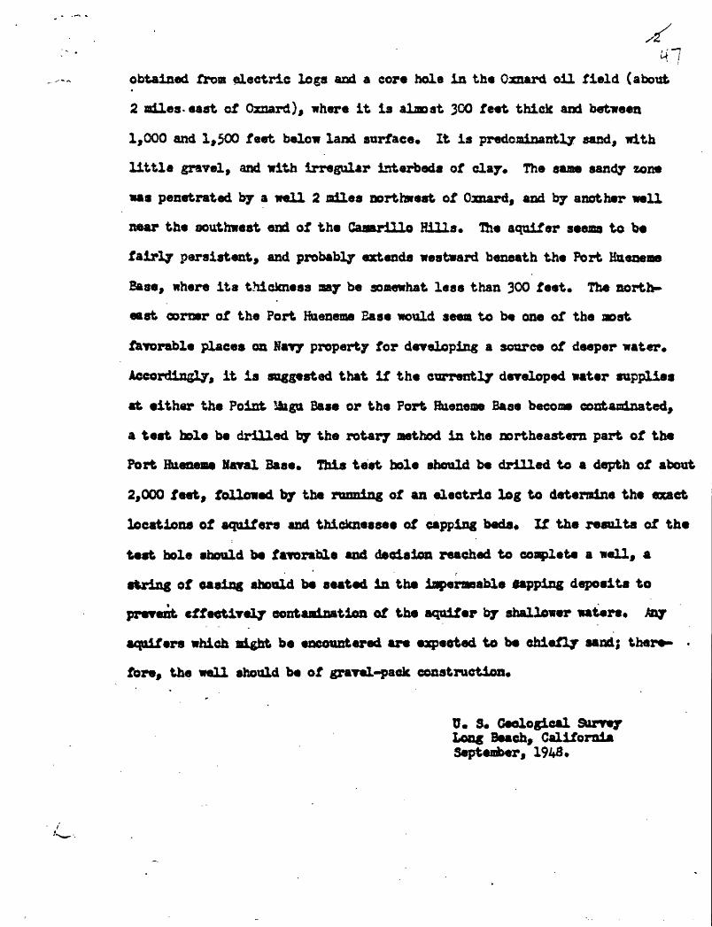
.^ /obtained from electric logs and a core hole in the Oznard oil field (about
2 Bdles-east of Oxnard), where it ia almost 300 feet thick and between
1,000 and 1,500 feet below land surface* It ia predominantly sand, with
little gravel, and with irregular interbeda of clay. The sane sandy zone
was penetrated by a well 2 miles northwest of Canard, and by another well
near the southwest end of the Caaarillo Hills* The aquifer seems to be
fairly persistent, and probably extends westward beneath the Fort Kueneme
Base, where its thickness aay be soaewhat less than 300 feet. The north
east corner of the Port Haeneme Ease would seem to be one of the aost
favorable places on Nary property for developing a source of deeper water*
Accordingly, it is suggested that if the currently developed water supplies
at either the Point iSigu Base or the Port Bueneoe Base become contaminated,
a teat hole be drilled by the rotary aethod in the northeastern part of the
Fort Hueneme Naval Base* This test hole should be drilled to a depth of about
2,000 feet, followed by the running of an electric log to determine the exact
locations of aquifers and thicknesses of capping beds* If the results of the
teat hole should be favorable and decision reached to complete a well, a
string of easing should be seated in the iaperaeable gapping deposits to
prevent effectively contamination of the aquifer by shallower waters* Any
aquifers which sight be encountered are eapeeted to be chiefly aand; there- .
fore, the well should be of gravel-pack construction*
U. S, Geological Surrey Long Beach, California September, 1943*

CN PRESET STATUS CF THE SAUKS FHOHTto supplement
Progress report on water supply for the Point Uugu Naval 3aae, Ventura County, California
By Arthur A. Garrett
The progress report of August 1943 for the Bureau of lards and
Docks indicated (p. 40) that the Geological Survey was proceeding with
field location and ^awpUng of active wells and open casings between the
Port Hueneme and the Point &gu Naval Bases, and within a mile or so of
the coast, to detaradne whether ocean water has advanced inland in the
coastal aquifers* and to define the present position of the front of such
ocean-**ter intrusion, insofar as possible*
The sampling was done July 21 and August 25-27, 1943. In all, 23open
active wells and two open casings were sampled* The waters in the/casings
were teated with portabla electrical conductivity equipment to determine
their salinity. Of the three wells cited on page 26 of the progress report
aa suggesting contamination, Hoe* 9-^-2 and 11-X-l were not found, and it
is likely they have bean destroyed* Veil 9-&-1, also mentioned on page 26,
was inactive when canvassed by the Geological Survey so that a water sample
could not be obtained* Plate 8, accompanying this memorandum, shows the
walls sampled by the Geological Survey, critical wells for which analyses
have been made by 9*Htf agencies, and the chloride content of the waters,
as described on the plate explanation.
Two important features were disclosed by the field canvass. This
eaoranduA soaaarises in brief these features!
! Tha quality of water yielded from the unnumbered well 0.5 mile
south of Hueneaa Road and just east of Perkins Road is suggestive of

contamination, possibly from the ocean* The saople taken August 26 contained
450 parts per million of chloride* The owner of the well reported that the
water "recently had become unfit for use. 1* Thus, this well nay be about at
the present front of active saline-water migration landward through the coastal
* aquifers* Veil 9-3-4* 0,25 mile north of the unnumbered well and 143 feet
dsep, was traversed with the conductivity electrode* Bo log is available for
the well and the position of the perforations is not known* From water surface
(15*1 feet below land surface) to 135 feet below land surface the water con
tained about 200 parts per million of dissolved solids* From 135 f**t to
bottom the dissolved solids content increased linearly to about 540 parts*
The dissolved solids content of native waters of that part of the Canard Plain
for which the chloride content ranges from 45 to 50 parts is about 650 parts
per million based on electrical conductivity* Hence, water of somewhat lower
dissolved solids content mat have collected in the well since it was last
pooped* If the perforations in the well are now open to one or more of the
coastal aquifers, it is reasonably certain that contamination has not yet
' reached the well* Thus, the front of contamination presumably lies somewhere
between this well and the unmmbered well 0*25 sdle south*
f 2* Analyses of water from wells 10-3-3, 10-K-15, and ll-fc-3, all south
of Caspar Road (pi* 3), suggest the existence of a local area yielding water
definitely poorer in quality than is normal for the area as a whole* This
condition may represent a lobe or wedge of saline water extending inland
from the ocean to the south. However, until further evidence can be obtained,
this inference is unsubstantiated* More likely is the possibility that

conditions here are T*Brfi«*» to those at wells ll-tf-15 and 11-^-20, about
2 niles northeast, which yield water containing from 5& to 573 parts of
chloride* The latter area is thought to yield water naturally n>re saline
than the adjacent areas of noraal water because of the presence of shallow
aquifera that contain natiTely inferior water which can enter the casing
in varying quantities depending upon existing wmter-1 evel differentials*
o The chloride content of water from well 10-W-14 (16,500 parts per million)
is not representative* The well was drilled to a depth of 250 feet in 1922,
and as inferred from the log, the casing presumably was perforated below 140
feet. TVhen visited in August 1943* the well was only 86 feet deep and the
water level was about 8 feet below land surface at least 8 to 10 feet
above the "static11 levels in nearby active wells. The conductivity traverse
ran by the Geological Survey showed sons vertical change in salinity which
is not considered significant because the well probably is- not now open to
any of the coastal aquifers* The casing of the well is corroded off at
land surface and is within a few feet of a drainage ditch* Hence* at seas
period of tidal over-run the well nay have been filled with ocean water thereby
accounting for the extreasly high chloride content of the water now present*
« The inforation oa chemical quality of well waters shown on plate 8
indicates that* as of August 1948, if salt water is aoving inland froa the
ocean into the producing coastal aquifers in the reach between the Fort
Hueneae and Point Mugu Vaval Basest
1* Hear Port fineness) the front of this saline contamination has not
advanced inland aore than 0*4 «ile*
2* Along the northnest lobe of the Point Jfega Kaval Base property*

tho front haa not advanced inl and aore than 0*6 mile (well lG-ff-21) to
0*3 Bile (veil 10-*?~d).i
0 For the present, therefore, there is no danger of saline intrusion
froa tho neat or southwest into the existing or proposed wells at tho Point
Saiga Naval Base* The conditions of saline intrusion directly to the south
of the Point ifcga noil field can bo learned only by constructing observation
wells, as described on page* 3d and 39 of tho progress report*
D. s. Geological Surrey Long Beach, California September 1943

CG
AB
AdH
S
1V
OI9
01
03
9
0
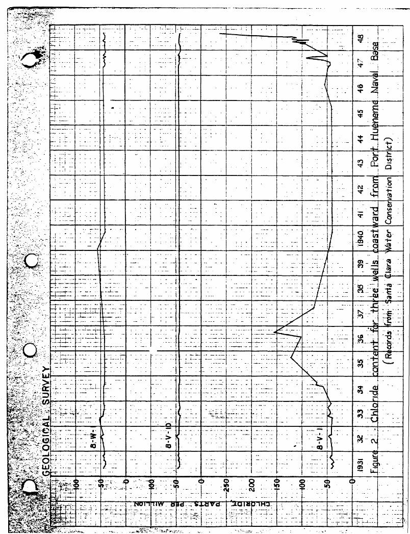
^v
^ilff,^
^^^
'^^^M
^^l^
m^^^^i^
^S
i^^
« £<S*&
*::^'1'£?3-- *' !'.' !/ , >.' '>: !'.'yfl"-fyfr.& s.: *
^-^ ̂^l^
jMl^
^i^
^.*
^£
^^:iJ

![[XLS]sknagar.nic.insknagar.nic.in/tender/IAYLISTSCSTHAISARBAZAR.xls · Web viewLOBHI BADAMA DURGA DEVI RAM SURAT SARVESH RAM KAVAL VADAMI SURESH GANGA CHANDRASEKHAR 1500-2500 PARSHURAM](https://static.fdocuments.in/doc/165x107/5ae172d77f8b9ac0428ec387/xls-viewlobhi-badama-durga-devi-ram-surat-sarvesh-ram-kaval-vadami-suresh-ganga.jpg)