Thermal Imagery Lab - d32ogoqmya1dw8.cloudfront.net · Investigating rock type and mineralogy using...
20
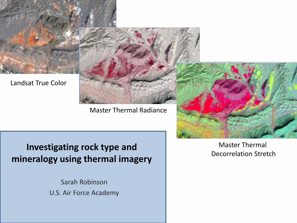
Investigating rock type and mineralogy using thermal imagery Sarah Robinson U.S. Air Force Academy Landsat True Color Master Thermal Radiance Master Thermal Decorrelation Stretch
Transcript of Thermal Imagery Lab - d32ogoqmya1dw8.cloudfront.net · Investigating rock type and mineralogy using...
Investigating rock type and mineralogy using thermal imagery
Sarah Robinson
U.S. Air Force Academy
Landsat True Color
Master Thermal Radiance
Master ThermalDecorrelation Stretch

Lake Mead East of Las Vegas, NV
Data Used:•Landsat Image
•MASTER Radiance Thermal Bands
•MASTER decorrelation stretch
Left (um) Right (um)41 7.578 7.93742 7.938 8.38243 8.429 8.79644 8.821 9.27745 9.484 9.88646 9.903 10.29047 10.317 10.92148 10.964 11.65249 11.850 12.34750 12.632 13.111
Landsat 7 (3,2,1)
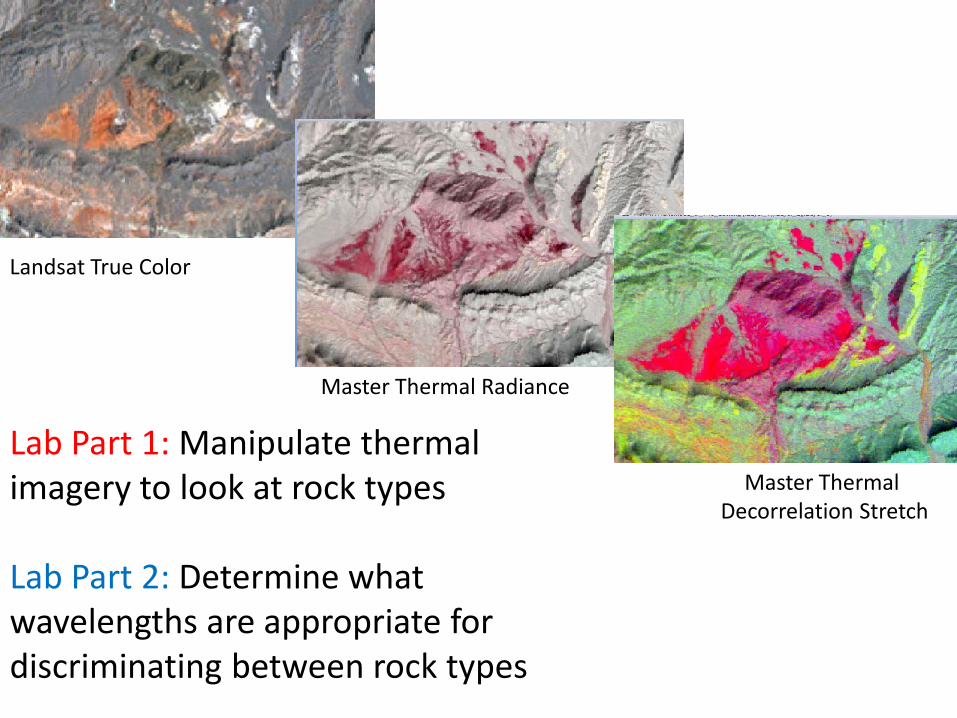
Landsat True Color
Master Thermal Radiance
Master ThermalDecorrelation Stretch
Lab Part 1: Manipulate thermal imagery to look at rock types
Lab Part 2: Determine what wavelengths are appropriate for discriminating between rock types
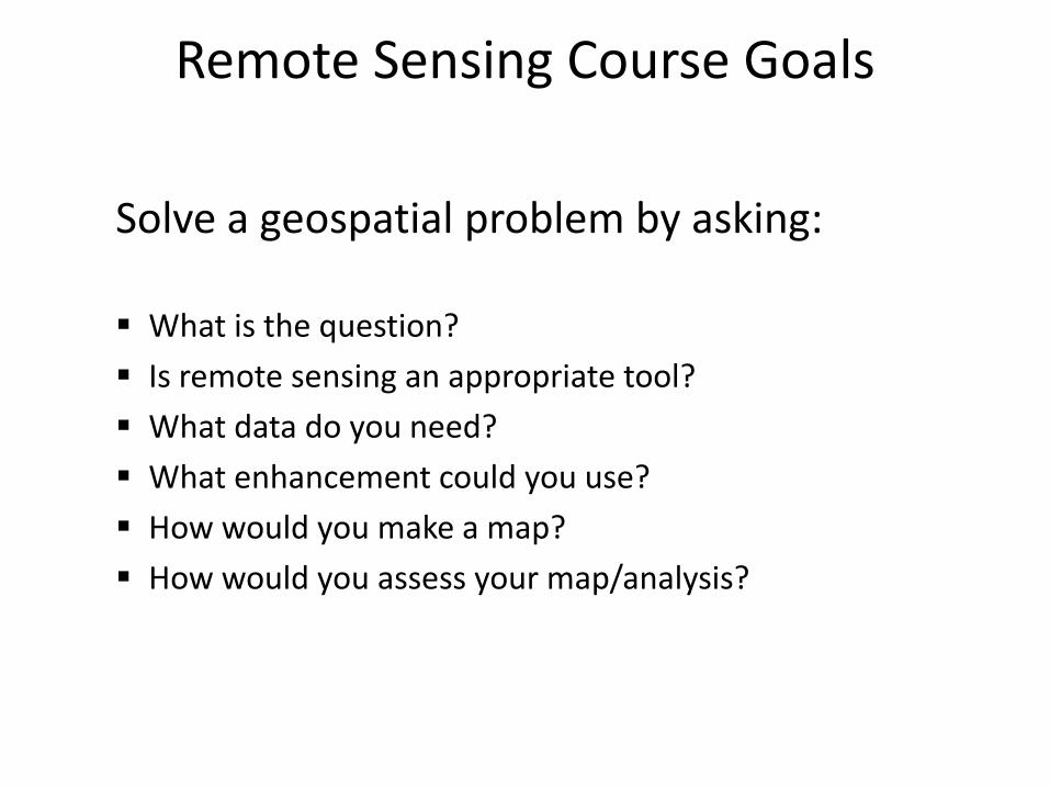
Remote Sensing Course Goals
Solve a geospatial problem by asking:
What is the question?
Is remote sensing an appropriate tool?
What data do you need?
What enhancement could you use?
How would you make a map?
How would you assess your map/analysis?

Remote Sensing Course Goals
What is the question?
Is remote sensing an appropriate tool?
What data do you need?
Spatial Resolution
Temporal Resolution
Radiometric Resolution
Spectral Resolution
What enhancement could you use?
How would you make a map?
How would you assess your map/analysis?

• What data do you need?– Spatial Resolution
– Temporal Resolution
– Radiometric Resolution
– Spectral Resolution• VIS is sensitive to
• NIR is sensitive to
• SWIR is sensitive to
• TIR is sensitive to
• Radar is sensitive to
Remote Sensing Course Goals

Remote Sensing Course Goals
• What data do you need?– Spatial Resolution
– Temporal Resolution
– Radiometric Resolution
– Spectral Resolution• VIS is sensitive to cultural features, iron oxide
• NIR is sensitive to vegetation, water/land boundary
• SWIR is sensitive to
• TIR is sensitive to
• Radar is sensitive to

Lab Goals
• Part 1–Demonstrate the similarities between analysis of
VIS/NIR/SWIR and TIR imagery–Review TIR specific attributes
• Part 2–Choose the appropriate spectral wavelengths to
differentiate between geologic units/materials

Lake Mead East of Las Vegas, NV
Left (um) Right (um)41 7.578 7.93742 7.938 8.38243 8.429 8.79644 8.821 9.27745 9.484 9.88646 9.903 10.29047 10.317 10.92148 10.964 11.65249 11.850 12.34750 12.632 13.111
Landsat 7 (3,2,1) Data Used:•Landsat Image
•MASTER Radiance Thermal Bands
•MASTER decorrelation stretch
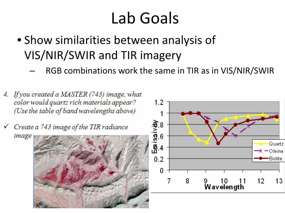
Lab Goals• Show similarities between analysis of
VIS/NIR/SWIR and TIR imagery– RGB combinations work the same in TIR as in VIS/NIR/SWIR
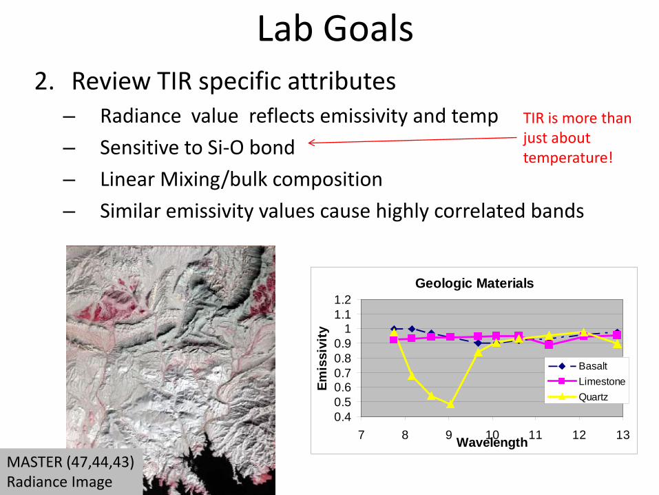
Lab Goals2. Review TIR specific attributes
– Radiance value reflects emissivity and temp
– Sensitive to Si-O bond
– Linear Mixing/bulk composition
– Similar emissivity values cause highly correlated bands
Geologic Materials
0.40.50.60.70.80.9
11.11.2
7 8 9 10 11 12 13Wavelength
Emis
sivi
ty
BasaltLimestoneQuartz
TIR is more than just about temperature!
MASTER (47,44,43) Radiance Image

Lab Goals3. Choose the appropriate wavelengths to differentiate
between materials– Develop “Rules of thumb” for TIR imagery
• What data do you need?– Spatial Resolution– Temporal Resolution– Radiometric Resolution
– Spectral Resolution• VIS is sensitive to cultural features, iron oxide• NIR is sensitive to vegetation, water/land boundary• SWIR is sensitive to• TIR is sensitive to• Radar is sensitive to

Visible (321) NIR/SWIR (456) TIRBasalt vs. Volcanic Neck ? ? ?
Landsat 7 (3,2,1)
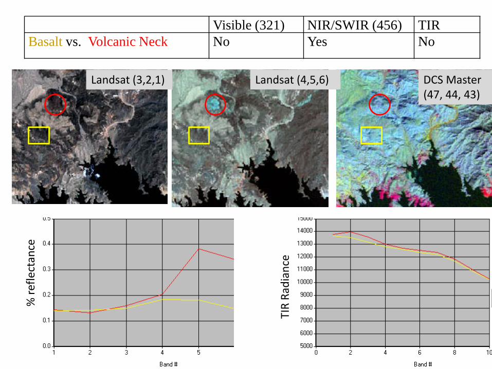
Visible (321) NIR/SWIR (456) TIRBasalt vs. Volcanic Neck No Yes No
% re
flect
ance
TIR
Radi
ance
Landsat (3,2,1) Landsat (4,5,6) DCS Master (47, 44, 43)

Remote Sensing Analysis Steps
What is the question? How do you differentiate Basalt vs. a Basaltic Volcanic Neck
Is remote sensing an appropriate tool?
Yes
What data do you need? NIR/SWIR-because sensitive to ferrous iron
What enhancement could you use?
RGB Combinations
How would you make a map?
NA
How would you assess your map/analysis?
NA
Landsat (4,5,6)

Visible (321) NIR/SWIR (456) TIR
Limestone vs. Colorado River Gravels
Visible (321) NIR/SWIR (456) TIR
Aztec Sandstone vs. Colorado River Gravels

Visible (321) NIR/SWIR (456) TIR
Aztec Sandstone vs. Colorado River Gravels
YES NO NO%
refle
ctan
ce
TIR
Radi
ance
Landsat (3,2,1) Landsat (4,5,6) DCS Master (47, 44, 43)
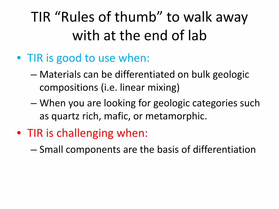
TIR “Rules of thumb” to walk away with at the end of lab
• TIR is good to use when:– Materials can be differentiated on bulk geologic
compositions (i.e. linear mixing)
– When you are looking for geologic categories such as quartz rich, mafic, or metamorphic.
• TIR is challenging when:– Small components are the basis of differentiation

Remote Sensing Course Goals
• What data do you need?– Spatial Resolution
– Temporal Resolution
– Radiometric Resolution
– Spectral Resolution• VIS is sensitive to cultural features, iron oxide
• NIR is sensitive to vegetation, water/land boundary
• SWIR is sensitive to Iron, clay
• TIR is sensitive to bulk composition, geologic rock types
• Radar is sensitive to

Questions?
Lake Mead, MASTER (47,44,43) Decorrelation Stretch Mosaic