Thematic Historical Overview of Nelson City · This list is Appendix 2 at the end of this report....
129
Thematic Historical Overview of Nelson City Written by John Wilson for the Nelson City Council as part of the Nelson Heritage Inventory Project FINAL DRAFT OCTOBER 2011
Transcript of Thematic Historical Overview of Nelson City · This list is Appendix 2 at the end of this report....

Thematic Historical Overview of Nelson City
Written by John Wilson
for the Nelson City Council
as part of the Nelson Heritage Inventory Project
FINAL DRAFT OCTOBER 2011

2

3
Contents
Introduction 5
Themes in Nelson’s History 11
Theme I The Land 13
Theme II People 17
Theme III The city’s growth and development 21
Theme IV Living in Nelson 33
Theme V Infrastructure and services 37
Theme VI Transport and communications 43
Theme VII The economy and livelihoods 55
Theme VIII Government, administration and politics 67
Theme IX Education and intellectual life 75
Theme X Religion 81
Theme XI Social Life 87
Theme XII Culture and entertainment 89
Theme XIII Sport 95
Theme XIV Health and social services 99
Theme XV The Military 101
Theme XVI Nelson’s and the rest of New Zealand 103
Appendices 105
Sources 129
Cover picture: The area of Nelson east of Church Hill in the middle years of the 20th century.

4
Picture Sources
Nelson Provincial Museum
Front cover; 19 bottom; 25 bottom; 26; 47; 48; 55; 62; 68; 69; 77; 87; 90 right; 91 top; 91 bottom; 92 left; 92 right; 96
Alexander Turnbull Library
13; 21, 24; 31; 70; 71; 72 top; 72 middle; 72 bottom; 75; 78 left; 78 right; 80; 81; 82 top; 82 bottom left; 82 bottom right; 83; 84 top left; 84 top right; 84 bottom left; 84 bottom right; 90 left
John Wilson
14; 19 top; 30; 33 left; 33 right; 34 top; 34 bottom; 35 top left; 35 top right; 35 middle; 35 bottom; 36 top; 36 bottom; 38 bottom left; 38 bottom right; 41; 44; 49; 50; 51 bottom; 52; 53 top; 53 bottom; 60; 63; 64; 65; 73 left; 73 right; 79 top; 79 bottom; 85 top; 85 bottom; 97; 99 top; 99 bottom
From Parsons, Story of New Zealand, p. 130
25 top
Private Collection, Akaroa
27
Jubilee History of Nelson City Council, opp. p. 36
38 top
Souvenir Nelson, 1952
45; 51 top

5
Introduction The Nelson Heritage Inventory Project
The writing of a thematic historical overview of Nelson City and compilation of a list of themes were steps in a project by the Nelson City Council (the Nelson Heritage Inventory Project) to review, and add to, its listings of heritage buildings, places and objects in the Nelson Resource Management Plan. The list is Appendix 1 of the Plan.
The purpose of the thematic historical overview was to identify significant developments and events in Nelson’s history and present them in a thematic rather than chronological way. A thematic historical overview, in particular, helps avoid concentration on particular building types, on specific periods or on particular classes of events. It was seen as an essential adjunct to the area-based surveys of surviving buildings and other historical features which were also part of the Heritage Inventory Project.
Associated with the writing of this Overview was the preparation of a list of major themes in Nelson’s history. This list of themes was then used to assess the adequacy of the existing listings in the Nelson Resource Management Plan and to suggest possible new listings which would ensure that the city was protecting a fully representative range of historic buildings, places and objects.
A 1992 Central Business District heritage inventory had already established an outline chronology of significant events in the growth and development of Nelson and identified people associated with that growth and development. This earlier inventory helped in the work of establishing themes in the growth and development of Nelson.
Once the preliminary research for the Overview had been completed, but before the Overview itself had been written, a list of topics covered in the research notes was drawn up. This is Appendix 1 at the end of this Overview. This list provided one basis for the preparation of a list of themes.
The existing listings in Appendix 1 of the Nelson Resource Management Plan were then examined to establish what historical topics or specific themes were already represented in the City Council’s listings. A list of possible themes which emerged from this examination of the existing listings under the Resource Management Plan was then drawn up. This list is Appendix 2 at the end of this report.
By way of comparison, the list of themes from a similar thematic historical overview for Christchurch, written by the author of this Overview in 2005, was also consulted. The list of themes from the Christchurch Overview is Appendix 3 at the end of this Overview.
A list of themes appropriate to Nelson was then drawn up. This list of themes follows this Introduction. The list of themes was then used to guide subsequent stages of the Heritage Inventory Project.
Once the list of themes had been finalised, the city’s current listings of heritage buildings, places and objects was broken down by theme, to check the extent to which the current listings of heritage

6
buildings, places and objects (in Appendix 1 of the Resource Management Plan) were fully representative of all aspects of the city’s history. This breakdown of the listings as they existed at the start of the project is Appendix 4 at the end of this Overview.
It became clear when the current listings were broken down by themes that certain topics, certain types of building and certain periods in Nelson’s history were much better represented in the current listings than others. This information then guided the selection of further buildings, places and objects for possible future listing. The goal was to identify additional buildings, places and objects that were possible new listings which would ensure that the list better represents all aspects of Nelson’s history. A breakdown of possible new listings prepared before possible additions to the City Council’s were identified is Appendix 5 at the end of this Overview.
This work on the thematic overview was then “married” to the results of an area-based survey of extant buildings and other historic features and a list of buildings, places and objects to be researched and assessed for possible additions to the existing list in Appendix 1 of the Nelson Resource Management Plan.
A large number of individual buildings, places and objects and a smaller number of precincts were then thoroughly researched to ensure that sufficient reliable information was available to enable the Council to decide whether these additional buildings, places, objects and precincts should be listed.
In addition the existing buildings, places and objects listed in the Nelson Resource Management Plan as category C were re-assessed to establish whether they should be protected under the Plan. The draft of the Historical Overview and the tentative list of themes were referred to during this exercise.
While this research was undertaken, this Overview remained in draft form. It has been completed after the rest of the project had been completed.
Why was a Thematic Historical Overview Needed?
It has long been established practice for bodies with responsibility for protecting and maintaining historic buildings, places and objects to list those buildings, places and objects which are considered worthy of protection and to rate them with a view to identifying those buildings, placed and objects which are especially deserving of protection and distinguishing them from those which do not deserve such a high level of protection.
More recently, attention has been given to whether the lists compiled over time by such bodies as the Nelson City Council adequately represent the reality of the historical development of the areas in which the listed buildings, places and objects are located. It has been noted that most of the existing lists of historic buildings, places and objects have not been compiled systematically to reflect all important aspects of the historical development of the areas where the surviving historic buildings, places and objects are found. Instead the present lists (and Nelson’s lists proved no exception to this generalisation) tend to reflect particular, often individual, enthusiasms or aesthetic preferences, or preoccupation with landmark buildings, buildings of particular architectural distinction or, in the particular case of dwellings, the houses and life styles of the wealthy and powerful. With a marked

7
tendency to over-represent the wealthy and powerful and mainstream religions, the lists tend not to reflect the social diversity and the full range of life-styles and interests of the inhabitants of the areas through time.
The Nelson City Council, cognisant of this recent thinking about the adequacy of its lists of historic buildings, places or objects and of the fact that these lists have not been compiled systematically with the full history of Nelson taken into account, commissioned the preparation of this thematic historical overview and of a list of themes that reflected the reality of Nelson’s historical development to enable it to select a properly representative range of historic buildings, places and objects so that its listings would, in future, include key examples of all the different types of historic and cultural places in Nelson and cover all aspects of the city’s history. By identifying the major historical processes that have shaped Nelson, the study enabled the Nelson City Council to ensure that all the stories of all stages of Nelson’s development (with the limitation noted below) can be told by reference to listed buildings, places or objects.
This thematic historical overview of Nelson City addresses primarily the extent to which the City Council’s listings were fully representative of all important stages and processes of the city’s development since 1841. By measuring the listings against the themes and the historical overview from which they are derived, the Council was able to begin ensuring that it has listed all the historically significant buildings, places or objects in Nelson City, regardless of their being considered of aesthetic worth or having already been identified as historic places.
This thematic historical overview does not address the issue of determining comparative significance, that is what rating individual historic buildings, places or objects should be given to determine priorities in protecting them. It does, however, help ensure that in any rating exercise that is undertaken other considerations are taken into account than aesthetic worth, association with the wealthy and powerful and other criteria that have determined listing in the past.
The thematic historical overview was written and the tentative list of themes drawn up by a professional historian. But because a main purpose of the exercise was to bring a wider range of historical knowledge and interests to decisions about which buildings, places or objects to list and to ensure that “alternative” narratives (those of the working class, women and minority ethnic and religious groups, for example) are reflected in the listings, it was thought important that the narrative in the historical overview and the tentative list of themes be subject to community scrutiny and refinement. The thematic framework, and the themes themselves, were also measured, to the extent possible in the time available, against local histories and histories of individual organisations or institutions, and were assessed critically by people with local historical knowledge. The thematic historical overview still has gaps which need to be filled. It is thought unlikely, however, that any further additions to or revisions of the historical material in the Overview will require a substantial revision of the list of themes.
It is important to emphasise that the list of themes has been compiled specifically for Nelson. It is not a national thematic framework, which would be based on a different narrative and give rise to a different list of themes. Some of the specific themes in the list would have a minor place in a national thematic framework, and the emphasis given others would be different if the perspective were national rather than local or regional. Nelson’s history is specific to the city and different from

8
the histories of other cities and regions in New Zealand. It is important that the list of themes on which decisions about the listing of historic buildings, places and objects in Nelson is based on the specific, individual history of the city.
The framework for decisions provided by the thematic historical overview and the list of themes has already helped ensure that the list of historic buildings, places and objects in the Nelson Resource Management Plan is both representative and comprehensive. It did this by providing criteria on which the adequacy of the present list was measured and guidance to identify and fill gaps in the list. But the process of listing historic buildings, places and objects is likely to continue, partly as a result of filling the gaps in the historical narrative which still exist in this Overview but also as a result of ongoing public recognition of individual buildings, places and objects.
There remains the problem that there may be themes which are not reflected in the city’s surviving historic fabric or resources. Some activities may never have created anything tangible which could survive to become an historic relic; others may have created something tangible but of such a transient nature that it has not survived (and could not have been expected to survive). It is important to note that although, in drawing up the list of themes and writing the historical overview, some attention was paid to the buildings, places and objects on the City Council’s present list (in Appendix 1 of the Nelson Resource Management Plan), an adequate list of themes cannot be based solely, or even primarily, on an inventory of what has survived.
A future project may be necessary to identify topics for which nothing tangible remains (or nothing except a site on which there is no old building, other structure or object) which could be listed. It may prove possible (or necessary) to ensure that these themes are “illustrated” in other ways than by protecting and interpreting tangible historic relics. The systematic placing of plaques and interpretation panels or ensuring that the Museum and Art Gallery “cover” the themes which cannot be illustrated by surviving historic fabric are examples of the ways in which themes which cannot be related to surviving historic fabric can still be recognised.
Completion of the Overview
A draft of the Overview was circulated in an incomplete state, prior to work being undertaken on possible new listings, to give those interested in the over-all project an opportunity to fill any outstanding gaps in the information presented, to suggest sources (books, booklets etc.) from which the “missing” information could be gleaned and to identify any omissions of whole subjects or topics. Useful assistance was forthcoming at this point from a number of people, particularly from Sarah Holman, Dawn Smith and Ken Wright
Work on completion of the Overview was then set aside while the author undertook his share of the research on the buildings, places, objects and precincts which were being considered for listing.
This final draft was not completed until 2011, after this work on the possible new listings had been completed. It is described as a “final draft” because of the remaining gaps in information. Some of these gaps in information are identified in the body of this report in italics within square brackets, in Themes VI, VII, X, XI, XII, XV and XVI. It is suggested that an “active file” be maintained to allow

9
people to add to the Overview as further research on different aspects of Nelson’s history is completed.
It had been the author’s hope to include in this Overview an Appendix identifying significant figures in Nelson’s life in all periods and over the full range of activities identified in the themes. Such a list of prominent Nelsonians is needed to ensure that buildings or places associated with them are identified and considered for listing. It proved not possible in the time available to compile such an Appendix. Work has already been done on the biographies of various Nelsonians, but the net needs to be cast wider and research undertaken on the lives of more people of significance (which is not the same as people of prominence) in Nelson’s history.
The author was also unable (a consequence of Christchurch’s earthquakes of 2010-2011) to complete research in the available census data on the size, ethnic composition, sex ratios and ages of Nelson’s population through the years. This information would have been included in Theme II, People.
It was a surprise to the author of this Overview, when he began work on it, to discover that there is no recent, authoritative history of Nelson City, as distinct from the province or region. His final suggestion is that the City Council, when the time is ripe, commissions a local historian to write such a definitive history of the city based on this Overview.
Caveat
The author of this Overview was not able, in the time available, to discover all the facts needed to make the Overview complete. He had to rely primarily on printed secondary sources and on material available on the worldwide web. The remaining gaps in the information in the Overview range from single facts (such as a date, street address or similar) to histories of organisations or institutions, or to whole topics for which sources were not readily available.
John Wilson
102 Wildberry Street Christchurch 8023
Ph. (03) 389 4887
Email [email protected]

10

11
Themes in the history of Nelson City
Theme I The Land The city’s site and climate
Theme II People Population statistics; ethnicity, ages, genders and marital status of citizens
Theme III The city’s growth and development The founding of Nelson; settlement history; physical growth, including street patterns; stages of built development; architecture; public open spaces; historic preservation
Theme IV Living in Nelson Dwellings; social class in Nelson
Theme V Infrastructure and services Water; sewerage; energy; fire-fighting
Theme VI Transport and communications Roads; railway; the port; air travel; telegraph and telephone
Theme VII The economy and livelihoods Farming and horticulture; minerals; industry; commerce and shopping; the professions; Nelson as a holiday destination; crafts and ‘alternative’ lifestyles
Theme VIII Government, administration and politics The provincial capital; the city council; the city’s boundaries; the central government’s presence in Nelson; law and order; Nelson’s place in national politics; Nelson as a centre of the conservation movement
Theme IX Education and intellectual life The Nelson Institute; schools; other educational institutions; the Cawthron Institute
Theme X Religion Churches and religious life
Theme XI Social life Clubs, societies, lodges and other social institutions and their premises and venues
Theme XII Culture and entertainment Libraries, theatres, art galleries; radio and television

12
Theme XIII Sport Sports as social activities; sports grounds
Theme XIV Health and social services Hospitals; the Plunket Society
Theme XV The Military Presence of the armed services; defensive measures; war memorials
Theme XVI Nelson and the rest of New Zealand Early ties with Wellington and Taranaki; the ‘secession’ of Marlborough; Nelson as a base for the exploration of the South Island; Canterbury and the droving routes; Nelson’s role in New Zealand’s national life

13
THEME I THE LAND The site of Nelson
Nelson is located where it is primarily because, in 1841, the advance guard of the New Zealand Company despatched from England to lay the foundations for the Company’s second settlement needed to find a site for the main town of the settlement which could be served by a port. The ‘discovery’ of the Nelson Haven, the only point on the Tasman Bay coastline suitable for more than a minor port, determined where Nelson would be sited.
There was a small area of relatively flat land along the lower reaches of the Maitai River about two miles away from a suitable site for a port on the shore of the Haven. This flat land was to prove sufficient for the town’s business area. One geographical feature of the area chosen as the site of the town was the “pretty eminence” rising from the middle of the flat, a “low isolate mound” which E.J. Wakefield described in 1842 as a “small Acropolis”.
Relatively low hills on which it would be possible to build lay between that area of flat land and the more extensive Waimea Plain. Little valleys ran back from the Maitai into the hills and provided further small areas of level land for settlement. There was little flat land at the site of the port itself, just inside the entrance to the Haven, but that deficiency was eventually made good by reclamation.
Rugged hills immediately east of the site hemmed in the town. These hills, and more rugged country south of the Waimea Plain meant that the town was
effectively cut off from the rest of the South Island, even though the boundaries of Nelson Province (as defined in the early 1850s) reached down to the Grey River on the west coast and to the Hurunui River on the east.
Its separation from the rest of the South Island by mountainous country explains in part why Nelson became known as, and to some extent actually became, a “sleepy hollow”: “hollow” because its site is a hollow surrounded on three sides by hills; “sleepy” because the fact that it had a relatively small hinterland and faced serious communication difficulties meant that Nelson was not destined to grow into a major city. These difficulties were compounded by the fact that the Haven did not have the
The "small Acropolis" at the centre of the site chosen for Nelson became the site of the city's cathedral. The first cathedral was opened in 1851.

14
potential to become a major port. Port Nicholson gave Wellington the opportunity to become the country’s major port in the Cook Strait region.
That there were few practicable overland routes to other parts of the South Island gave communication by sea great importance in Nelson’s history. For periods of its history it can be considered as more a Cook Strait than a South Island settlement. The links across the water to Wellington and Taranaki were at times more important than overland links to Canterbury, Westland and Otago, even though the Tophouse “gap” provided a route down the Wairau into Marlborough and down the Buller to the West Coast.
Vegetation and climate
When European settlement of Nelson began, most of the site was covered in toe-toe, fern and manuka, though, valuably, parts of the site were forested. There were areas of large trees on one side of and for some distance up the Maitai and also up the valley of the Brook. One locality, about 150 acres of native beech and pine, is still called The Wood. This area provided the early settlers with timber for buildings and firewood. 1
The sheltering ranges protected Nelson from southerlies and easterlies and gave the town a more equable climate than other parts of the South Island. Northerlies and westerlies, however, ensured that the area received sufficient rainfall for agriculture and horticulture, even though it enjoyed more sunshine hours each year than almost all other parts of New Zealand.
An 1842 settler observed that Nelson’s climate was “delightful” and constituted “the settlement’s greatest value”. When the Austrian scientist Ferdinand Hochstetter spent time in Nelson in 1858-59 he noted that its “delightful” climate was one reason why Nelson was justly considered “one of the most pleasant places of sojourn in New Zealand”.
The climate enabled Nelson to become an important centre for horticulture and especially for warm climate crops like hops and tobacco. The climate also explains Nelson’s popularity as a holiday destination. Its reputation as “sunny Nelson” was of economic importance to the town.2
Though Nelson enjoyed a favourable climate, the site was susceptible to natural disasters. High rainfall in
1 McAloon, pp. 14, 229-30; Allan, pp. 1-2, 76-77, 101; Broad, p. 28 2 McAloon, pp. 229-30; Allan, pp. 1-2; Broad, pp. 28, 123
After a 1970 flood, a length of the Brook was confined to a concrete channel to reduce the risk of future floods.

15
the hills surrounding the town at times caused serious floods. April 1929 brought the worst floods for 20 years in the Brook. There were further major floods in 1939 and 1954. After the 1954 flood the Collingwood Street bridge, which had stood since 1877, had to be replaced. An August 1970 flood in the Brook caused two deaths and huge property damage. After this flood, the Government subsidised the construction of a new bed and channel for a length of the Brook.3
Nelson is located in a geologically active area and has been affected by earthquakes. There was an earthquake early in the town’s history on 16 October 1848; another in February 1893 damaged the spire of Christ Church, on Church Hill. The town was affected by both the 1929 Murchison and 1968 Inangahua earthquakes. A smaller local earthquake in 1962 caused a major landslip at Tahuna.4
Generally, however, the site on which Nelson was built has proved, since European settlement began, no more seriously subject to natural hazards than the sites of New Zealand’s other towns and cities.
3 Bell, pp. 22, 91-96 4 Bell, pp. 44-45; Nelson Provincial Museum display

16

17
THEME II PEOPLE The city’s population
In 1850, Nelson’s population was 1,297, with a further 2,075 in the suburbs and rural districts. The total population of the province in that year, including those living in Golden Bay and in what was to become Marlborough, was 4,780. By 1869, the population of the Province had risen to 22,501.5
Between 1876 and 1896, the city’s population was more or less static at around 6,600. These were years of depression in the nation as a whole. Through these years, Nelson was home to only a small percentage of the country’s total population. It had already fallen far behind the country’s “four main centres”. By 1901, with the return of prosperity, Nelson City’s population had increased to around 7,000 and by 1906 to 8,164.6 It remained small relative to the country’s “four main centres”.
National economic conditions explain why through the 1920s and 1930s Nelson’s population again scarcely grew. But as the country emerged from the Depression, in 1936, the city’s population topped 12,000. The development of fruit and tobacco growing in Nelson’s rural “hinterland” contributed to this growth of population, which continued through the post-war years.7
The population continued to grow through the 1970s. It increased by 12 per cent between 1971 and 1976, with fully half of that growth in Stoke and Atawhai, on the city’s southern and northern edges respectively. Reflecting Nelson’s popularity as a place to retire to, a higher proportion of the population than in most other parts of the country was people over 65. But there was also a high proportion of families with children.8 By 2009, the population of Nelson City had topped 42,000.
The ethnic composition of Nelson’s population
Maori
The association of the Boulder Bank (Te Taero o Kereopa) with the exploits of Kupe, one of the Polynesian discoverers of New Zealand, takes the traditions of the Nelson area back to the very beginnings of human occupation of New Zealand.
At the time of European settlement, the area, known as Wakatu or Whakatu (there are at least four separate traditions explaining the origin of the name), was within the tribal area of a group of related iwi (tribes) from Taranaki which had occupied the very northern parts of the South Island, from Golden Bay to the Marlborough Sounds, in the 1820s. These iwi had supplanted Ngati Apa, which had in turn supplanted an earlier iwi, Ngati Tumatakokiri, in the early years of the 19th century.
5 Broad p. 111; Bowman, p. 35 6 McAloon, p. 138 7 McAloon, pp. 138, 154 8 McAloon, p. 218

18
Ngati Tumatakokiri and earlier iwi had lived in Whakatu for several hundred years before the arrival of Europeans. The quarries for argillite (a stone valued for weapons and tools) in the hills behind Nelson were worked from around 1200 AD. Whakatu, with the Haven and the extensive forests on the flats and hills back from the sea, was a rich and valued “mahinga kai” (area where foodstuffs were readily available) and the climate was conducive to the growing of the Maori staple kumara. There was a settlement at Auckland Point, Matangi Awhio, from at least the 1400s and the area became the site of exchanges between Maori and Pakeha in the early years of European settlement. In 1842 five one-acre sections at Auckland Point were set aside as part of the Nelson “tenths” and the area remained an important base for Maori in Nelson for many years after the European town had been established.9
The “tenths” were the land set aside by the New Zealand Company for Maori after Nelson had been purchased by the Company. There were other sections in the city which were part of the “tenths’, but this land was not occupied to any great extent by Maori, although it remained in their ownership and some eventually passed to the Whakatu Incorporation. The resident population of Maori in Nelson (whether of the iwi from which the land had been bought in the 1840s or “immigrants” from other tribal areas) was relatively low through most of the second half of the 19th century and all of the 20th century. The nearest concentration of Maori to Nelson through these years was at Motueka. It was not until 1995 that an “urban marae”, called Whakatu, was established in Nelson.
European
Nelson’s first European settlers of the 1840s were predominantly English. But in that same decade the province (if not the town) gained its first significant group of non-British settlers. In 1843-44 a number of German immigrants arrived on the St Pauli and the Skiold, as a result of contact in Europe between Germans interested in emigrating and the New Zealand Company. When they arrived to find the Company no longer employing new immigrants, numbers left for Australia and those who remained settled mainly in the Moutere district, founding the town of Sarau, rather than in Nelson City.10
The only significant non-British group to settle in Nelson in the first half of the 20th century were Italians. From the beginning of the 20th century, Italian immigrants (some from families which had settled a little earlier or at about the same time in Wellington) began growing tomatoes and other horticultural crops in the area of Nelson known as The Wood.
In 1931, members of the local Italian community founded the Club Italia, which became a focus of ethnic identity for Nelson’s Italians. Nelson’s small Italian community became divided against itself during World War II, some supporting Mussolini (and becoming the subjects of hostility because of this) while others served in the New Zealand forces.11
By the 1950s there were 37 acres of land in The Wood under glass. Most of the glasshouses, and most of the associated market gardens in the area, were owned and worked by the members of
9 Mitchell, pp. 302-03 10 McAloon, p. 37; Broad, pp. 84-86 11 McAloon, p. 182

19
some 40 to 50 Italian families. By the end of the 20th century, however, with the value of land within the city rising, most tomato-growing in The Wood had ended and the town’s Italian community lost some of its cohesion as a result.
Other European com-munities in Nelson were very small and never attained the prominence of the Italians
Non-European Immigrants
Nelson has the distinction of having been where New Zealand’s first recorded Chinese citizen settled. Appo Hocton arrived as a steward on one of the immigrant vessels. With the help of the ship’s surgeon, Thomas Renwick, he stayed in Nelson, worked for the doctor for some years then went into business on his own account. Descendants still live in Nelson.12
The Chinese and Indian communities in Nelson were small through the second half of the 19th century and first three-quarters of the 20th century. When New Zealand’s immigration regulations were relaxed in the 1970s, the number and sizes of such communities as the Chinese and Indians grew, with a differentiation developing in Nelson, as elsewhere in New Zealand, between those whose families had deep roots in New Zealand and those whose families were newly arrived.
12 Willmott, p. 10
The house built by members of the Fiatarone family in the area of Nelson known as The Wood reflected the family's Mediterranean origins.
Appo Hocton -- Nelson's and New Zealand's first recorded Chinese resident.

20

21
THEME III THE CITY’S GROWTH AND DEVELOPMENT The founding of Nelson
Nelson was founded as the second settlement of the New Zealand Company. The settlement was planned in accordance with the ideals of Edward Gibbon Wakefield. Land was to be sold to intending settlers (and investors) at a “sufficient” price – one high enough to deter speculation and to ensure that labourers could not acquire land too easily, but not so high as to make it impossible for working men to eventually become small landowners. The price was also to be high enough to allow the Company to pay the passage of working people who could not afford it and to provide funds for building churches, schools and other institutions and to build roads and undertake other public works. The aim was to achieve a proper balance between labouring and propertied immigrants and to replicate the class relationships of an ideal, pre-industrial England and so create a miniature Britain in the Antipodes.
This “model” or “ideal” profoundly influenced Nelson’s early development. It envisaged a central town surrounded by compact communities of larger and smaller farms, which was what the Nelson Settlement effectively became. Understanding that Nelson was founded by people with a distinct vision of the social structure the new settlement should have helps make sense of Nelson’s early political and social history.
The New Zealand Com-pany’s advance party of officials and workers, led by Arthur Wakefield, left England in 1841 on the Arrow, Whitby and Will Watch. The ships put in first to Port Nicholson where the infant New Zealand Company settle-ment of Wellington had been founded scarcely two years previously. When the Governor, Hobson, ruled out the second Company settlement being founded where the Otago and Canterbury Settlements were later located, the three vessels crossed Cook
The site of Nelson was chosen largely because The Haven, seen in the background of this early view of the town, provided a good harbour, behind the Boulder Bank.

22
Strait and explored Tasman Bay for a suitable site for the settlement. A site for a town was found just inside the entrance to the Nelson Haven in October 1841. The Arrow entered the Haven on 1 November, followed soon afterwards by the other two ships. In December, the Union Jack was raised and a cannon mounted on Britannia Heights. (The site of the landing and raising of the flag are both marked.)13
This founding of Nelson was preceded by negotiations with local iwi about the acquisition of land on which to establish the settlement. These negotiations did not constitute a “purchase” because after the signing of the Treaty of Waitangi only the Crown could purchase land from Maori. Instead the negotiations were based, and possession of the land eventually taken, on the basis of the purchases the New Zealand Company had made prior to February 1840 in the Cook Strait area. Once the land had been secured, “tenths” were set aside as part of the agreement. These were areas of land within the area “purchased” which were reserved to Maori. On Tuckett’s surveyed plan of the town’s one-acre sections, the sections that were part of the “tenths” were scattered throughout the city.14
Immigrant ships followed this advance party through 1842 and 1843. Nelson’s Anniversary Day, 1 February, commemorates the arrival of the first of the immigrant ships, the Fifeshire, which was quickly followed by the Lloyds, Mary Ann and Lord Auckland. More than 500 settlers had arrived by the end of February 1842 and about 2,000 by May 1842. The first Anniversary Day was celebrated in 1843 with horse-racing and ploughing and rifle matches. By the 1850s regattas were a feature of Anniversary Day celebrations.
By mid 1843 18 ships had brought more than 3,300 settlers to Nelson. Most of the immigrants were farmers, labourers and tradesmen. Though many of those who had purchased land in Nelson from the Company in England chose not to emigrate, the early settlers included some landowners and capitalists.15
Taking up the land
The early development of Nelson was impeded by problems with finding, surveying and allocating land for the settlers. Land had been sold by the Company in England in 201-acre allotments. Each allotment consisted of 150 acres of rural land, 50 acres of “accommodation” or “suburban” land and one town acre. The Company sold only 451 of 1,000 allotments to 274 purchasers. Of the purchasers, only 85 had emigrated by 1850.16
The constraints of the chosen site became apparent early in Nelson’s history. The mountainous ranges meant that Nelson had available only limited areas of farmable land; the flat or gentle country was in scattered and isolated sections of the Province. Finding enough land to satisfy those who had purchased land orders that entitled them to 201 acres for each allotment purchased became a major problem for the Company officials in Nelson. To the problems caused by restricted land were added those that resulted from too many labourers being among the actual settlers and
13 Broad, pp. 5-15; McAloon, pp. 10-14; Allan, pp. 36-40, 71-75, 81, 85-90; A City of History pamphlet 14 Mitchell, pp. 292-302 15 Allan, p. 96; McAloon, p. 16; Broad, p. 17 16 Allan, p. 71; Bowman, p. 34

23
from a deficiency of capital in the new settlement. Absentee land ownership meant that the early farms were separated by land owned in England, or not sold at all.
These related problems, and the fact that the surveying and allocation of land was not completed until some time after the settlers arrived, meant that the initial years of Nelson’s history were hard for many immigrants. The only available work for some time for many immigrants was road building, and this work lasted only as long as the Company had funds to pay for it. The funds eventually ran low, and hardship increased.17
The 1,100 town acres (the extra 100 acres were for public purposes and to provide land for Maori under the purchase agreements) were allocated in April 1842. Distribution of the suburban sections was delayed until August 1842 and January 1843. The 50-acre suburban blocks took all the available good land. Land had still to be found for the 150-acre rural sections. After the suburban lands had been allocated, farms did spring up in the Waimea valley and the Moutere and Motueka districts, though the land held by absentee landowners was not immediately put to productive use. These early farms were not large-scale capitalist enterprises, on which labour was employed, but small enterprises worked by tenants or by those who purchased small lots from those who had bought land orders from the Company. By 1844 there were 5,782 sheep and 918 cattle grazing Nelson land and 1,262 acres were under cultivation, mostly for the growing of cereals and potatoes.18
The urgent need to find more land to meet the claims of those who had bought land orders from the Company and to give the town of Nelson a good-sized agricultural and pastoral hinterland led directly to the most dramatic incident in Nelson’s early years – the Wairau Affair. After the discovery in 1842 of the Tophouse route into the Wairau Valley, the Wairau was seen as a solution to the problem of finding sufficient farmable land to provide all those who had purchased allotments from the Company with their 150 rural acres. In the Affair, members of a party from Nelson surveying land in the lower Wairau Valley which chiefs of the Ngati Toa tribe insisted had not been sold were killed by a Ngati Toa party on 17 June 1843. The Affair not only dashed the hopes of securing sufficient land but also deprived Nelson of its leaders. Arthur Wakefield was among those killed. Ruth Allan described Nelson after the Wairau Affair as “a body beheaded”.19 In Nelson a fort, named Fort Arthur after Arthur Wakefield, was built on the flanks of Church Hill to defend the settlement against a feared attack which never eventuated. Remnants of the earthworks of the fort remain.
The problems of allocating land bought from the Company were not resolved until 1847, after the Government’s Lands Claims Commissioner, William Spain, had awarded land to the Company (in 1845) and the Wairau and adjacent country had been finally purchased from Ngati Toa (in 1847). In 1848, new Crown grants were issued, new land regulations promulgated and some re-selection of land permitted. From this time on, Nelson at last had an agricultural and pastoral hinterland and by the end of the decade substantial “exports” chiefly to Wellington, and chiefly ale, beer, flour, timber and wool, were passing through the Port of Nelson.20
17 Allan, pp. 71, 193; Broadgreen House booklet 18 McAloon, pp. 16, 20-21, 24-25; Broad, pp. 83, 111; Allan pp. 137ff., 193, 200-04 19 Allan, pp. 76, 83ff., 137, 239; McAloon, pp. 29ff. 20 McAloon, pp. 40-41, 49-51; Broad p. 111; Allan, pp. 307, 353 and ch. XI passim

24
The early town
Nelson’s first buildings were prefabricated immigration barracks, a landing depot and storehouse erected on the foreshore at the port. A second barracks was erected on the inland knoll that became Church Hill.
The first arrivals, in the three ships that reached Nelson in October 1841, lived either in the barracks or in tents. But rather quickly, a forge was established, timber was cut and brick making began. (As early as March 1842, four brick fields were in operation. One of these early brick works was on Vanguard Street.) The construction of cottages began. By the time the first immigrant ships arrived in February 1842, the town’s streets had been laid out and “quite a whare town” of dwellings and sheds grown up on the flat land chosen as the site of the town. The first dwellings were built, in about equal numbers, of timber and of earth. By the middle of 1842, when the town’s population had reached around 2,000 and after the town acres had been distributed, there were around 250 “good” houses completed, 50 more under construction and around 230 temporary whares or huts still in occupation. By 1845 there were also around two dozen brick dwellings. The cost of bricks fell in 1843, allowing them to be used for whole buildings and not just chimneys.21
The early town grew rather rapidly because, as the settlers waited for the accommodation and rural land sections to be found, surveyed and allocated, they spent their (often limited) capital on building. Because the town sections were a full acre each, the early town was scattered and dispersed. John Barnicoat described it as “very extensive, though not very populous”. The town also acquired a scattered character because, until the land allocations were settled and titles confirmed, Arthur Wakefield let labourers among the settlers build whares where they fancied, on the understanding that once the land had been surveyed and allocated, the builders of the whares would come to an arrangement with the owners about the occupation and ownership of the land .22
21 Allan, pp. 77-79, 98-100, 138-39; McAloon, pp. 14-15, 41; Broad, p. 37; Tritenbach, p. 97 22 Allan, pp. 77-79, 137ff.; McAloon, p. 41
The infant city of Nelson still had the appearance of a "frontier" town by the time the first Anglican Cathedral had been built on Church Hill.

25
Early public buildings in the town included a post office and a courthouse and jail. Commercial premises were built. Early industrial buildings within the town included sawmills, brick works, breweries, tanneries, a flax mill, flour mills and a cloth-weaving factory. (Some of these early public, commercial and industrial buildings are discussed in greater detail under later themes.)23
By the 1850s, though it was still to some extent a raw frontier village and still rather scattered and dispersed, Nelson could be considered at least on the way to becoming a developed town. It was 23 Broad, pp. 22-23; Nelson Provincial Museum displays; A City of History pamphlet
By the end of the 19th century, Nelson was still a relatively small town but had an established, settled air.

26
already a commercial and industrial centre and had an established port. In 1858 it contained 434 wooden buildings and 27 of brick and stone. Though most of the buildings were modest, utilitarian structures, the larger buildings by this time included an Anglican church on Church Hill, a Wesleyan chapel and a Masonic hall.24
When Nelson became a city in 1859, by virtue of its having been made the seat of an Anglican bishop, it
exhibited little of that bustle and activity that should characterise a city; but there was a great improvement in the street architecture – rickety, barn-like stores had given place to handsome shops, and the old packing-case style of houses had been superseded, in many instances, by dwellings having some pretensions to taste and comfort.25
The geographical spread of the town
The original survey of the town shows a grid of streets laid out over the flat land on the lower reaches of the Maitai River and over the lower hills surrounding that flat land. Nelson could not grow east because of the ranges in that direction, but it could spill over the hills between the original town and the lower reaches of the Waimea Plain, south from Tahuna towards Stoke and Richmond and could grow north along the eastern shore of the Haven towards Atawhai and Wakapuaka. It also grew, geographically, with periodic reclamations of tidal mudflats at the mouth of the Maitai.
In the 20th century, most geographic growth occurred on the northern and southern edges of the town, especially, at first, in the Tahuna and Stoke areas, then later at Atawhai. Between 1944 and
24 McAloon, p. 54; Bowman, p. 37 25 Broad, p. 124
In the late 19th and early 20th centuries, development spread from the flat land and valleys onto nearby ridges and hillsides. This is a turn-of-the-century view looking across to the Mount Street ridge.

27
1948, the number of houses in Tahuna increased from 300 to 400. This rapid expansion, and the consequent demand for better urban services in the area, contributed to Tahuna’s becoming administratively part of the city in 1949. Further growth towards and in Stoke led to Stoke (along with Monaco, Annesbrook and Enner Glynn) also becoming part of the city in 1958. One notable spurt of expansion in Stoke occurred when 30 of the 50 acres of the Broadgreen property were sold for subdivision.26
The town also grew, in the second half of the 20th century, with the “infill” development of large sections, a residue of the town sections having originally been a full acre.
Public open spaces
From its earliest years, Nelson has had significant public open spaces. When the town acres were first allocated in 1842, the Governor, Hobson, insisted that certain acres be reserved for public uses, including the court, jail, customs house, places of public worship, public wharves, markets, forts, cemeteries and a recreation ground. Several of these reserves were subsequently built on, but others remained public open spaces. The nine acres of Trafalgar Square, centred on Church Hill, were reserved as sites for a church, courthouse and other public buildings, but most of the area remained open space. Three acres between Shelbourne and Collingwood Streets were intended for the goal and cemetery. Most of this area was subsequently built over, though site of the old cemetery, known as the Hallowell Cemetery, on Shelbourne Street is still marked.
26 McAloon, p. 197; Broadgreen House booklet
Looking out over Tahunanui at about the time the rapid post-war expansion of the area began.

28
Six acres set aside between Brougham and Van Diemen Streets were intended for a military station. This area became Copenhagen Square, though the name did not persist because some early Nelsonians felt that the man after whom their town had been named had not behaved well at the Battle of Copenhagen.27 Part of this reserve was also used as a cemetery from 1851. The graveyard was closed in 1910 and the area is now Fairfield Park.
Land was set aside by Tuckett between Hardy and Nile Streets (where Domett Street now runs) for a botanical garden. In 1857 the suitability of this area for a botanical garden was examined by members of the Horticultural Society. They found the land unsuitable for that purpose because the Brook flowed across it and identified land across the Maitai River where sections were still available as suitable for a botanical garden. The Botanical Gardens were subsequently located on the present site.28
Trafalgar Park was first developed in 1888 on the private initiative of the Athletic Ground Company as a venue for cricket, football, cycling and athletics. Land was reclaimed from the mudflats for these purposes, but passed into the hands of a mortgagee when the company ran into financial difficulties. The City Council bought the park from the mortgagee in 1891 after Parliament had authorised using the unexpended balance in a fund raised originally for the “refugees” from the Taranaki Land Wars of the early 1860s to buy the ground.29
The development of Queen’s Gardens on an historic site began in 1887. A lagoon in the area had been used as an eel pond by Maori who had camped and fished at Whakatu before the area was “purchased” by the New Zealand Company as a site for Nelson. The area had been used from the 1860s by the Acclimatisation Society and the Provincial Government (whose building was on the same city block) had planted trees on the Society’s grounds. When the provinces were abolished in 1876, the central government handed over the area around the eel pond to the Nelson City Council. In 1880, part of the pond was filled in and a “serpentine water” formed. To mark Queen Victoria’s 50th jubilee, the area was designated Queen’s Gardens in 1887. By 1889 grass had been sown and trees planted. Improvements continued through the 1890s. Ornamental gates were subsequently placed at the Hardy and Bridge Street entrances to the Garden. The Hardy Street gates were erected in memory of Henry Trask, Mayor of Nelson from 1890 to 1900, and the Bridge Street gates in memory of Albert Pitt, a local politician. The Gardens gained a rose garden and footbridge in 1923 and a pool with a fountain at the Hardy Street gates in 1967. The city’s South African War memorial and later World War I trophies were located in Queen’s Gardens.30
The town’s major public open spaces in 1891 were the Botanical Gardens (21 acres), Trafalgar Park (14 acres), Victory Square (6 acres), Queen’s Gardens (3¼ acres) and Trafalgar Square.31
Anzac Park, previously known as “Milton’s Acre”, was bought by the City Council in 1897 and the low-lying land filled in 1912. In 1926 the Council bought additional land from the Railways
27 Nelson Historical Society Journal, vol. 2, no. 1, 1966, p. 11. 28 The Examiner, 18 September 1947 29 Broad, p. 128 30 Tritenbach, pp. 97-98; Bell, p. 11 31 Broad, p. 181

29
Department to extend the park. The park was given a new layout in 1954, when stormwater drains were laid in the area. Pioneer Park, on reclaimed land, was opened in February 1929, after the Council had, the year before, decided to put the unemployed to work filling the “King’s Acre” using rock fall from the Rocks Road.32
A site for a powder magazine was set aside on the Boulder Bank and forts were to be built on reserved land on Fifeshire (now Haulashore) Island.33 The island subsequently became privately owned and in 1925 was given by the Moncrieff family to the city as a reserve.34
Through the 20th century, increasingly large areas of the higher hills to the east of the city came into public ownership as reserves. Thomas Cawthron, Nelson’s greatest benefactor, bought 2,500 acres along the line of the Dun Mountain Railway (see Themes VI and VII) and presented the land to the city.35 In the early 1970s, the City Council bought around 1,800 acres of land in the Maitai Valley below the Maitai motor camp and named the reserve created with this land Waahi Taakaro.36
The Grampians, a low but precipitous range to the west of the valley of the Brook, separating that valley from the small valley up which the Waimea Road runs, were planted by the City Council to provide an appropriate backdrop to the city. In 1954, a plan to plant pines on 37 acres of The Grampians was rejected in favour of deciduous and evergreen ornamental trees and shrubs. A Beautifying Committee was set up to undertake this planting. A 1959 fire was a setback to these plans, but the area was replanted.37
In 1974, the City Council owned or administered around 26,700 acres of open space. Gardens, sports grounds and reserves totalled 4,450 acres. Cawthron Park, which also served as a waterworks reserve occupied another 2,496 acres. Another 21,500 acres of indigenous forest was also waterworks reserve.38
In the second half of the 20th century, the Council added two important areas of land in Stoke to the city’s tally of public open spaces. An area of 12 acres of woodland and gardens around Isel House (a significant house begun in the 19th century and added to in 1913) was bought by the City Council in 1960, immediately after Stoke had joined the city. Nearby, another historic house Broadgreen passed into public ownership in 1965. Subsequent to the grounds of Broadgreen becoming public open space, a notable collection of rose bushes was moved to Broadgreen. 39
Cemeteries are among the city’s historic public open spaces. No marked graves remain in the small Hallowell Cemetery on Shelbourne Street, close to Church Hill. 40 Nelson’s Quakers had an early cemetery on Rutherford Street on the site of their 1853 meeting house. There are headstones and
32 Bell, pp. 10, 11, 13, 33, 68, 76-78 33 Allan, pp. 97-98 34 Bell, p. 33 35 New Zealand Historic Places, no. 35, p. 22 36 Bell, pp. 76-78 37 Bell, pp. 76-78 38 Bell, pp. 76-78 39 Tritenbach, pp. 99-100 40 Trevor Horne Heritage Trail leaflet

30
grave surrounds marking the last resting places of early settlers at Fairfield Park. The cemetery there was originally on the military reserve known as Copenhagen Square.41 The Wakapuaka Cemetery was opened in 1861 after the Provincial Government had bought land in the area two years before. The cemetery is an important open space in Wakapuaka. The Marsden Valley Cemetery, serving the Stoke and Richmond areas, was completed in 1956.
The role of architects in Nelson’s growth
Nelson has had its own small but active architectural profession from the earliest decades of its history. Of the number of architects who practised in the town from the 1850s into the late 19th century, the two most influential were Maxwell Bury (who also practised elsewhere in the country in his short New Zealand career) and William Beatson, who was Nelson’s most prolific architect from his 1851 arrival in Nelson until his death in 1870. Beatson, unusually, came from England with a formal training in architecture behind him and this was reflected in the
number and quality of buildings he designed over two decades. His son Charles Edward Beatson also practised as an architect, in both Nelson and Wellington. Other members of the first generations of Nelson architects were John Scotland, J.W.G. Beauchamp, H.B. Huddleston and A. Dobson.
Among the key Nelson architects of the first half of the 20th century were William Houlker and Arthur Griffin. Houlker was in partnership at different times with Rix-Trott and Charles Duke. He received his early education in Nelson, studied architecture in England, then returned to Nelson. Arthur Griffin was in practice in Nelson from the early 1900s until around 1960, though he had largely retired by the 1940s. Griffin’s largest commission was the rebuilding of the Nelson Hospital in the 1920s.
In the years after World War II, the practice of architecture in Nelson was largely the sole preserve of Alex Bowman. Bowman studied architecture at Canterbury College and as an employee of the Christchurch firm Helmore and Cotterell. On his return to New Zealand in 1948, after war service and the study and practice of architecture in England, Bowman settled in Nelson and remained in practice in the city until 1985. He in effect brought Modern architecture to Nelson. He took over the practice of Houlker and Duke which had been the major architectural practice in Nelson in the first half of the 20th century. Other architects who practised in Nelson in the second half of the 20th
41 A City of History pamphlet
The surviving work of Nelson's most important early architect, William Beatson, includes this house on Collingwood Street.

31
century included George Shing, who was active in the 1960s, 1970s and 1980s and Ian Jack who set up his practice in the 1970s and was still in practice in the early 21st century.
Architects from outside Nelson who had an influence on the development of architecture in the city seem to have come mainly from Wellington (rather than Christchurch or Auckland). Architects who were primarily based in Wellington who designed buildings in Nelson in the 20th century included Cedric Firth, James Mair (who was Government Architect from 1923 to 1941) and James Hall-Kenney.
The influence of the historic preservation movement
The demolition of the Nelson Provincial Government Buildings in 1969 is now recognised as a key moment in the history of building preservation in New Zealand. The demolition of the buildings was controversial and from at least that date there was an active “preservation lobby” in Nelson. The local committee of the New Zealand Historic Places Trust was the main but not the sole focus of historic preservation activity in Nelson. The “lobby” failed to prevent the demolitions of such notable buildings as the Municipal Building of 1903 and the Post Office of similar age, but had some successes. The most notable success was probably the preservation of the South Street precinct,
which set a precedent of national significance for the protection of a group of relatively humble buildings as opposed to the preservation of a single building of note. Fairfield House was also saved through the efforts of historic preservation “activists”.
The 1969 demolition of Nelson's Provincial Government Buildings was a key incident in the development of the historic preservation movement nationwide.

32

33
THEME IV LIVING IN NELSON Early dwellings
When the first settlers arrived in Nelson in 1841-42 they lived first in the immigrations barracks or in tents, but rather quickly built whares or huts, probably initially in the “native style” using raupo, and
then cottages of weatherboard or earth (cob, pisé de terre, adobe). Bricks were used initially just for chimneys, but after they had fallen in price in 1843, also for complete dwellings. The use of earth became less common from the 1860s on, and brick cottages and houses remained relatively rare. As elsewhere, throughout colonial New Zealand, weatherboard as cladding and shingles, then corrugated iron, as roofing materials quickly became the norm in Nelson for most dwellings, large and small.
The city’s earliest surviving houses date from the 1850s. They include a cob building of 1853, with timber additions, at 35 Washington Road, the large cob house, Broadgreen, built in Stoke in 1855, Woodstock, built around 1850, and the older parts of Warwick House (originally Sunnyside), built in 1854 but extended in the 1860s.42
Later 19th century dwellings
Through the rest of the 19th century, the history of domestic architecture in Nelson followed a similar course, in respect of styles and materials, to the history of domestic architecture in the rest of New Zealand.
Cottages of weatherboard with tin roofs followed familiar colonial forms, simple rectangular buildings, usually with gable ends but occasionally with hipped roofs, many with verandas in front
42 A City of History pamphlet; Vine, pp. 12-14; Bowman, p. 38
Throughout Nelson there are surviving 19th century cottages that were the homes of the city's early families.

34
and lean-tos at the rear and some with dormers. In the cottages built on South Street in the years after the 1863 subdivision of a single town acre, Nelson has one of the country’s best examples of a group of 19th century cottages. There are also surviving 19th century cottages elsewhere in the older parts of the town, for example on Tasman Street. Also surviving are the Dear cottages, five of weatherboard and one of brick, built on Rutherford Street in 1887 by William Dear.43
In the later 19th century, Nelson also acquired a number of larger houses. Their size and the elaboration of their detail when they are compared with the working class cottages of the same era are convincing evidence of class differences in 19th century Nelson. These larger houses were built in a variety of styles, notably Carpenter Gothic and Italianate. None depart from the norms of 19th century New Zealand domestic architecture. Well-known examples are Fairfield and Melrose, but there are, in different parts of the city, a considerable number of other larger 19th century houses.44
Some of the city’s larger 19th century houses gain added historic importance because of their association with people prominent in Nelson’s, and national, history. They include Broadgreen, which is not only notable because it is a
large house built of cob but also because it was the home of Edmund Buxton whose firm, E. Buxton and Co., played an important role in Nelson’s 19th century commercial life. Both the first and second owners of Warwick House/Sunnyside, Alfred Fell and Nathaniel Edwards, were also important
43 Trevor Horne Heritage Trail leaflet; A City of History pamphlet 44 Beatson, pp. 80-90, 113-15; New Zealand Historic Places, 35, pp. 31-33
A large number of the grander homes in which wealthier residents of Nelson lived in the 19th century have survived. Melrose (above) is now in public ownership. So is Isel House (below) in Stoke.
35
merchants in 19th century Nelson. Isel House in Stoke, which was significantly extended and altered in 1880 and again in 1905, was the home of one of Stoke’s leading early settlers, Thomas Marsden, and then of his son James.45
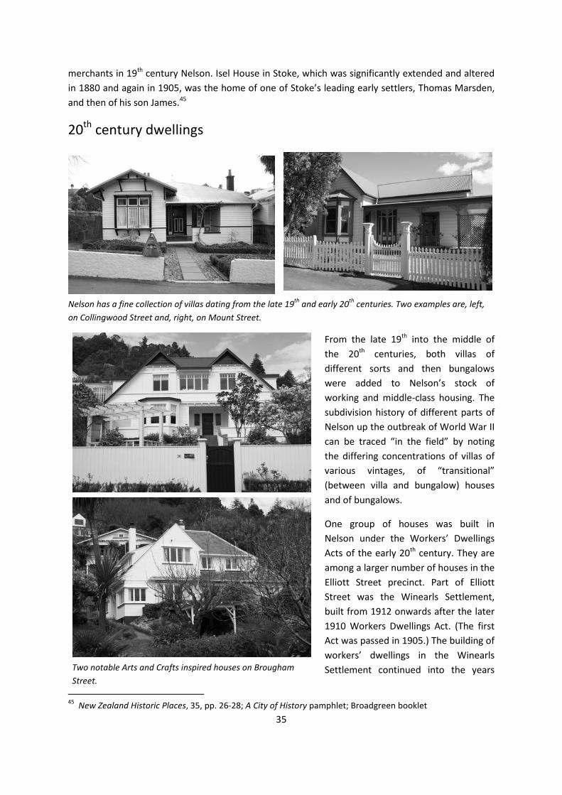
20th century dwellings
From the late 19th into the middle of the 20th centuries, both villas of different sorts and then bungalows were added to Nelson’s stock of working and middle-class housing. The subdivision history of different parts of Nelson up the outbreak of World War II can be traced “in the field” by noting the differing concentrations of villas of various vintages, of “transitional” (between villa and bungalow) houses and of bungalows.
One group of houses was built in Nelson under the Workers’ Dwellings Acts of the early 20th century. They are among a larger number of houses in the Elliott Street precinct. Part of Elliott Street was the Winearls Settlement, built from 1912 onwards after the later 1910 Workers Dwellings Act. (The first Act was passed in 1905.) The building of workers’ dwellings in the Winearls Settlement continued into the years
45 New Zealand Historic Places, 35, pp. 26-28; A City of History pamphlet; Broadgreen booklet
Nelson has a fine collection of villas dating from the late 19th and early 20th centuries. Two examples are, left, on Collingwood Street and, right, on Mount Street.
Two notable Arts and Crafts inspired houses on Brougham Street.

36
after World War I.
The city also acquired state houses built from the 1930s into the 1950s and beyond. There are several “pockets” of state houses in different parts of Nelson. One notable group of post-war state houses is on Wolfe Street.
Apart from the earliest state houses, domestic architecture of the years between the two world wars is represented in Nelson by a number of Art Deco and Streamline Moderne houses. From the 1950s
on Nelson’s housing stock expanded dramatically. Again, the houses mostly followed national design trends. Nelson possesses good and in some cases exceptional examples of all post-war New Zealand house styles.
The City Council entered the arena of public housing while S.I Russell was Mayor, from 1958 to 1962. The first flats erected for the elderly were named after Russell. By 1977, the City Council owned 99 units.46 (There was a much earlier precedent for the erection of housing for the elderly in need with the brick Renwick cottages, built under a private bequest in the 1880s.)
46 Bell, p. 120
Two of the interesting group of post-war State houses on Wolfe Street.
In the late 20th and early 21st centuries Nelson added buildings of architectural interest to its housing stock. This house was designed by Nelson architect Ian Jack.

37
THEME V INFRASTRUCTURE AND SERVICES Early improvements
The history of the infrastructure and services that keep cities healthy and habitable is often overlooked, despite their importance in urban history. Though power lines are obvious, water pipes and sewerage lines are out of sight, and therefore often out of mind.
The interesting history of Nelson’s infrastructure and services begins with the establishment of a Board of Works under the Town of Nelson Improvement Act of 1856. After the abolition of the provinces, responsibility for infrastructure and services passed entirely to the Nelson City Council. Unlike some other larger urban centres in New Zealand, Nelson never had any ad hoc bodies (a drainage board, a transport board or an independent electricity supply authority) dealing with particular aspects of infrastructure and services.
Energy
The early settlers had ample sources of firewood close to hand for their initial energy needs. There were sources of coal in the wider region, notably in Golden Bay, from which coal was brought to Nelson by coastal ships. There was also a local coal mine at Stoke which for some years supplied household fuel to the city at the rate of two tons a day.47
One of the public works projects of the Provincial Government was the construction of a gasworks, which came into operation in 1874 and continued to supply Nelson City consumers with gas until 1983. The City Council acquired the gasworks (along with the city’s waterworks) under the 1877 Nelson Gas and Waterworks Sale Act.
Gas production continued even after electricity had become the major form of energy used in Nelson homes and eventually factories. The works were remodelled in 1930 and in 1966 the Haven Road gasholder was repaired. A new naptha gas plant (the fourth gas plant on the same site) was commissioned in 1972, but through the 1970s use of gas declined and the works were closed in 1983.48
Electricity came relatively late to Nelson. In 1919, the Nelson City Council considered the possibility of securing a supply of hydro electricity for the city and investigated undertaking a combined scheme with other local authorities to build a scheme at Nelson Lakes. The following year it also considered a combined scheme at the Wairoa Gorge. But in 1921, the Council opted, with ratepayer support for a loan for that purpose, to build a coal-fired thermal power station on Wakefield Quay to
47 Broad, p.126 48 Broad, pp. 179-81; Bell, pp. 59-60; McAloon, p. 87; Nelson Provincial Museum display

38
serve the city alone. This station was commissioned in 1923 and supplied the city with electricity until the Cobb scheme was completed after World War II.
In the years after 1923, the Waimea County Council took the initiative in investigating hydro-electric schemes on the Gowan, Cobb or Wairoa Rivers. The Nelson City Council held aloof from these investigations until, in the late 1930s, it was obliged to become involved because it was
expected that the existing thermal power station would not be able to meet the growing demand. Work on the Cobb power scheme began in 1936, but power did not become available from the scheme until 1944 (after the Government had taken over responsibility for building it). In the meantime, the Nelson City Council brought new equipment to extend its thermal plant.
The Cobb scheme was not finally completed, with the commissioning of the dam, until 1956. In that same year Nelson was finally connected to the national grid. The thermal power station was used as a standby through several months of drought in 1955-56, then finally decommissioned, after 33 years of service, in 1956. It was retained as an emergency standby plant until a new substation was completed. The building was then stripped of its equipment, and in 1961 leased for private uses.49
Older substations, for example those in Anzac Park and on Bronte Street, apparently date from the time the city’s steam power station was built. In 1959-60, soon after Nelson had been connected to the national grid, a new substation was built on Haven Road (on a site which had been occupied by
49 McAloon, pp. 163-64, 186, 188; Bell, pp. 10-11, 54-59
Nelson's thermal power station on Wakefield Quay supplied the city with electricity from 1923 until the 1950s. The building has survived.
Older substations in Nelson dating from the early periods of electricity supply in the city are found at Anzac Park (left) and on Bronte Street (right).

39
the Haven Road school until 1927 and which had after the closure of the school been bought by the City Council).
From 1923 until 1991, distribution of electricity around Nelson was undertaken by the city’s Municipal Electricity Department. Following reforms in the electricity industry Nelson Electricity Ltd took over this role.
Water and sewerage
The Provincial Government gave Nelson City its first waterworks as well as its gasworks. Water came initially from streams and rivers and shallow wells. As the town grew through the 1850s, the need for a reliable water supply for sanitary welfare and for fire-fighting became greater. The idea of drawing water from the Brook was first floated in 1858-59. In 1865, the Provincial Government authorised a £20,000 loan for waterworks and sent the Provincial Engineer, John Blackett, to Melbourne to investigate how a supply could be arranged. The waterworks, designed by Blackett, were inaugurated on 16 April 1867. A seven-inch main brought water into the city from the upper reaches of the Brook.
By 1900, the supply had become inadequate, because of both population increase and building at higher levels. A dam was built on the Brook in 1905, but was leaking seriously by 1908, when a weir was built above the dam and a new eight-inch main was laid. In 1922, new mains were laid and reticulation extended. The scheme drawing water from the Brook served the city until 1940s, though the capacity of the dam was by then insufficient. Wells to supplement the supply had been sunk in different parts of the city in the 1920s and 1930s.
To set this situation right, the building of the Roding River scheme, to serve Richmond and parts of Waimea County as well as Nelson City, was proposed. The scheme was promoted by the Hume Pipe Company. The Nelson City Council initially opted for a cheaper scheme drawing water from the Maitai, but a government grant of £25,000 for the joint scheme persuaded the City Council to shelve the Maitai scheme and agree to take water from the Roding River. This scheme came into operation in 1940-41 and was finally completed in 1943. In 1945, the scheme was serving 16,500 residents. The number had increased to 25,000 by 1954, mainly because of growth in Richmond, Stoke and Tahuna.
The city’s demand for water led to a revival of the Maitai scheme. (Land had first been bought in the Maitai Valley to protect the water catchment in 1918.) The scheme finally went ahead in 1963, initially without a dam which was abandoned because of its cost. Improvements to the water supply system based on reservoirs at Thompson Terrace, the Botanic Gardens and Stoke were made. Design work for a new dam on the Maitai went ahead in 1973-74, but the proposal was controversial. An organisation, the Friends of the Maitai feared building the dam would result in a loss of recreational and landscape values. The Council finally voted for the scheme to go ahead in 1982. Two more years of planning and appeals followed before construction of the new dam began. It was completed in 1987.50
50 McAloon, p. 218; Bell, pp. 10-11, 36, 49-54

40
The city continues to draw its water from both the Roding and Maitai Rivers. A treatment plant at Tantragee Saddle treats the water from both schemes.
Drainage of Nelson began with the digging of a ditch down the line of Trafalgar Street to carry stormwater from the hills to the sea. The Nelson Provincial Council discussed the town’s drainage problems at its second session, which opened in November 1854. There were at that stage cesspools round the town and open drains carrying effluent from pig sties and slaughter houses to the rivers and the sea. An outbreak of dysentery in 1855 prompted the closing in of the Trafalgar Street ditch, but the Provincial Council’s main response was not to improve the drainage system but to provide an alternative water supply to contaminated local sources.
The most serious problems arising from poor drainage of effluents were alleviated by the inauguration of the water supply system in 1867. Minor improvements to the city’s drains were made subsequently. In 1872, a drain was built to take both sewage and storm water from Rutherford, Hardy, Nile and Bridge Street into the Maitai. Some effort was made to separate sewage and storm water in 1894, but ten years later, untreated effluent was still flowing into the Boat Harbour.51
Decisive action to inaugurate a comprehensive drainage scheme was not taken until the early 20th century. The new drainage scheme which was completed in 1909 included reticulation of most of the built-up area with sewage (as opposed to storm water) sewers, but the sewage was still discharged without treatment into the sea.
The system was upgraded in 1936. After the 1950 amalgamation of Tahuna with the City, sewers were extended to serve the houses, industries and holiday accommodation in the area. These sewers were in place by 1953.
In the early 1960s, construction began on pumping stations to pump sewage north of Nelson to Wakapuaka, from where it could be discharged to the open sea, beyond the Boulder Bank. In 1968-70, a water right was obtained for an outfall in Tasman Bay and the outfall pipe was constructed. Not until 1979, when a 26-hectare oxidation pond was built, was Nelson’s sewage treated before being discharged to sea.52 In 1984 a pipeline, paid for by two large fishing firms, Sealords and Skeggs, was laid across the Haven and through the Boulder Bank to discharge sewage and fish-processing waste into Tasman Bay. The sewerage system was upgraded by the City Council in 2007.
Fire fighting
The Provincial Council first began investigating a water supply system for Nelson in the late 1850s partly because the existing water supply was insufficient for fighting fires. The first brigade was formed and an engine procured in 1858 at the instigation of insurance companies, but the brigade soon went into recess. In 1863, the Provincial Government bought a fire engine to protect the Provincial Government Buildings. The brigade was revived in 1864, funded by the Nelson Board of Works and insurance companies. In 1865-66 a shed, designed by the Assistant Provincial Engineer,
51 Broad, p. 119; McAloon, pp. 141-42 52 Bell, pp. 10-11, 39, 53; Nelson City Council pamphlet on drainage

41
Henry Handyside, was built near the Provincial Government Buildings in a similar style to the Buildings. (It is now the only surviving reminder of the Provincial Government Buildings themselves.) In August 1866, a large fire on Bridge and Collingwood Streets prompted the formation of a new volunteer fire brigade and the following year a new, larger engine house was built on Harley Street.53
The City Council became involved in fire fighting services in the 1890s, when the insurance companies declined to continue their subscriptions to the volunteer brigade. The Council struck a fire rate and purchased new plant. In 1933, the City Council passed responsibility for the city’s fire brigade to a Fire Board and the new board quickly built a new station on Halifax Street which was opened in 1935.54 This fire station was superseded (though the building remains) in 1992 when a new fire station opened. A new fire station was built in Stoke in 1957-58.
53 Broad, pp. 181-82; Hanson “Old Engine House”, passim 54 Broad, pp. 181-82; Bell, pp. 105-06
The Stoke Fire Station is an interesting example of Nelson architecture of the 1950s.

42

43
THEME VI TRANSPORT AND COMMUNICATIONS Transport in Nelson’s history
Issues to do with transport and communications loom larger in the history of Nelson than they do in the histories of other New Zealand towns of comparable size or regional importance. The difficult terrain that separated Nelson from the rest of the South Island made the forging of adequate overland transport links to Marlborough, the West Coast and Canterbury a long and interesting story. Hopes of a rail link to the rest of the South Island rail system dominated the minds of many Nelsonians for generations. For a town which is now without a railway, railways loom large in Nelson’s history. Nelson’s problems with establishing reliable overland transport links to the rest of the South Island also explain the importance of the port in the city’s history. This reliance on transport by sea made Nelson, from some points of view, less a South Island town than a Cook Strait town, connected more closely by sea links to the North Island centres of Wellington, Wanganui and New Plymouth than by land links to any South Island centre.
Transport difficulties partly explain why Nelson never developed into one of the country’s “main centres”, even though it was one of the earliest European settlements. By the 1880s, the “four main centres” each had populations of more than 40,000 while Nelson’s was around 6,600. The towns Nelson most closely resembles have always been, since the 19th century, New Plymouth and Timaru, always larger, by virtue of their ports, than other towns in their regions but never coming close to Auckland, Wellington, Christchurch or Dunedin in size or economic importance.55
The Port
Nelson’s first European settlers arrived by sea, and the town’s site was chosen primarily because it was possible to develop a port there. Early appreciation that The Haven provided a good natural harbour led to comparisons being made by early settlers between Nelson and Piraeus, Venice and Trieste. For several decades after it had been founded, geographical isolation made the sea Nelson’s primary means of communication with the rest of New Zealand and the world.56
That The Haven afforded sufficient shelter and deep water for a port ensured that Nelson would become a regional capital, economically as well as politically. Vine observed perceptively that Nelson’s name was chosen wisely because its association with and dependence on the sea has been vital to its existence.57
55 New Zealand Historic Places, 35, p. 21; McAloon, p. 103 56 Broad, p. 24; Bowman, p. 30 57 Vine, p. 60

44
Development of the port began immediately after the settlers had arrived in 1841-42. As early as November 1841, leading marks and buoys were placed to mark the difficult channel to the harbour entrance. The first major public work undertaken in Nelson was the road between the town and the port, which took a year to build.58
Through the 1840s a regular traffic of sailing ships, both coastal and to and from Britain passed through the narrow channel between the shore and the end of the Boulder Bank. In the 1850s, the steamer Nelson began making regular trips to Wellington, New Plymouth, the Manukau and Otago. That particular service was short-lived, but it indicated the role the port was to play in Nelson’s life. In 1855 there were three wharves at the port – Morrison and Scandler’s, Nicholson’s and Custom House – but at none could a vessel float at low water. The first deep-water wharf was built in 1856.59
In 1860, the Provincial Government built a new wharf with warehouses and cranes and at the very end of the provincial period, in 1876, another new wharf was built. This remained the port’s principal wharf until the 1950s. By the later 1860s and 1870s the port dominated the city’s economy. Steamers provided regular services to West Coast ports, Wellington and the small ports of Tasman and Golden Bays – Tarakohe, Takaka, Collingwood, Pakawau, Puponga and Motueka. Regional roads were poor so imports and exports were trans-shipped at Nelson onto and from overseas-trading vessels, or vessels trading between Nelson and Wellington, which could not use the smaller ports of the region.60
One notable feature built in provincial days was the lighthouse on the Boulder Bank. It was prefabricated in England and erected on the Boulder Bank in 1861-62. It was first lit on 4 August 1862. It replaced a beacon which had been placed on the Boulder Bank in 1848. The wooden keepers’ cottages which once clustered round the foot of the lighthouse were removed in 1915 and survive in suburban Nelson. Use of the light discontinued in 1982, but the tower has been retained as an historic relic.61
Although Nelson had reasonable road links with Marlborough and the West Coast by the 1880s, sea
transport remained important for passenger and cargo traffic. Use of the port was hampered by the difficult entry through the channel between the end of the Boulder Bank (which became eventually Haulashore Island) and the shore. The 1842 wreck of the Fifeshire on the rock in the channel drove the point home. As the steamers trading directly between Nelson and Britain became bigger, the narrow, shallow natural entrance to the port became an even more serious impediment to Nelson’s direct communication with Britain. In 1892, a reef that was a hazard on the channel into the port was blown up.
58 Allan, pp. 81, 100 59 Broad, pp. 117, 182-84 60 McAloon, pp. 104, 167-68, 183ff. 61 Vine, p. 60; A City of History pamphlet
Houses which once stood beside the lighthouse on the Boulder Bank have been re-located to suburban Nelson.

45
Talk of a cut through the Boulder Bank began in the 1880s, but no action was taken until after the Nelson Harbour Board had been established in 1901. Early in its life, the Board raised a loan to cut a channel and extend the port’s wharves.62
The cut through the Boulder Bank, which turned the tip of the Bank into Haulashore Island, was finally opened in July 1906, although it took 18 months more work to complete. The first major overseas cargo ship (the Rakaia) sailed through the cut in April 1909. The opening was enlarged in the 1950s and again in the 1960s.
The first significant re-clamations of land at the port were completed in the 1930s. In the 1950s, new dredges which came into service in 1952-53 enabled more of the mudflats at the mouth of the Maitai to be reclaimed. Following this reclamation, the McGlashen Quay, the first part of which was opened in November 1960, was built. There were further re-clamations in the late 1970s and the late 1990s. Through
the second half of the 20th century, oil storage facilities and premises for processing
and distributing a great variety of products and goods were built on the progressively reclaimed land.63 By 2000 the port was handling more than two million tonnes of cargo a year.
The reclamations have meant that Haven Road, which once ran along the shore, with the railway between the road and the sea from 1878, is now far from the water.
Because overland links between Nelson and the rest of the South Island remained poor and difficult, the port was important, into the middle of the 20th century, for passenger as well as cargo services. The New Zealand Steam Navigation Company was founded in Nelson in 1852 and by 1856 there were regular steamer services from Nelson to Wellington, Lyttelton and Melbourne.
A ferry service to Wellington was started by the Union Steam Ship Company in the 1870s. A local firm, the Anchor Steam Shipping Co., was founded in 1880 and ran coastal shipping services out of Nelson. In 1901 it was incorporated as the Anchor Shipping and Foundry Co. In 1908, the Union Company took a shareholding in the Anchor Company, which subsequently ran the Wellington service until it was discontinued in 1953. There were scheduled passenger boat services between
62 Allan, pp. 90-91; McAloon, pp. 104, 125; New Zealand Historic Places, 35, p. 21 63 McAloon, pp. 125, 192; Nelson Provincial Museum display
Into the 1950s, when this picture of Port Nelson was painted, the port was still small and relatively undeveloped.

46
Nelson and Tarakohe into the 1920s. When the ferry service to Wellington ended, the roads to Blenheim and Christchurch were still not sealed but the ferry service from Picton became the usual way Nelson people reached Wellington. The Nelson City Council’s later efforts to have Nelson become a terminus for the roll on/roll off inter-island ferries (which began to ply between Wellington and Picton) were unsuccessful.64
A number of local shipping lines based in Nelson played an important part in the history of the town’s sea transport links. The Nelson Steam Navigation Company was established in the 1850s by Captain Nicholson (who lived in a surviving house, Woodstock). The Anchor Line was the dominant Nelson-based line in the city’s history. Formed in the 1880s it was initially part of the mercantile firm Nathan Edwards and Company. (The line was associated with the Anchor Foundry, which is mentioned under Industry). At least four other small shipping companies ran steamships between Nelson and other New Zealand ports and there were other ships engaged in the coastal trade which were owned by individual Nelsonians.65
The Railway
It is ironical that although Nelson never gained its much-desired rail connection to the rest of the South Island and has, since 1955, been without a railway at all, it was where what some claim was New Zealand’s first railway line was built. (The claim is disputed by some because steam-powered locomotives were not used on the line.)
The Dun Mountain Railway was built to bring ore down from the mineral belt on the Dun Mountain. There were deposits of both copper and chrome ores on the mountain, chrome then being in demand in the English cotton industry for dyes. Horses hauled the empty ore waggons up the line which returned, laden, by gravity down to the city and then on to the port. The line was opened in 1862. The full length of the line was short-lived. The last load of chromite ore came down it in 1866, but the stretch of line through the city had a much longer life as a passenger tramway (see under Public Transport).66
The Nelson to Glenhope railway had a much longer life. Proposals for a line to the West Coast were made in the first decade of New Zealand’s railway history, the 1860s. The line was to follow the Waimea, Motueka and Hope river valleys to the Buller River at Kawatiri and so down to the Coast. The route had been explored by Brunner, Rochfort, Mackay, Haast and Travers in various expeditions from the late 1840s to the early 1860s.
Nelson people became convinced that to secure the progress of the province they needed not just roads but a railway through the interior of the South Island to the West Coast and Canterbury. At that time the West Coast down as far as the Grey River was part of Nelson province. In 1863, the Provincial Government supported raising a loan for a railway into the upper Buller, but the Central Government quashed the idea.
64 Bell, pp. 18, 85; McAloon, p. 191 65 McAloon, p. 103; Bowman, p. 38 66 Nelson Provincial Museum display

47
It was not until Julius Vogel came to power, pushing a programme of immigration and public works, that Parliament approved further work on planning the line. In 1873 an Inland Com-munication Committee collected evidence to justify building the railway and in May of that year the first sod of the Nelson to Foxhill Railway, as a government project, was turned. The
railway to Foxhill was opened in January 1876. The extension of the railway beyond Foxhill quickly became a dominant issue in provincial politics and by the end of the 1880s the line had reached Belgrove. The line from the town to the port opened in 1880.
Subsequently, following the abolition of the provinces and as a result of agitation in Canterbury for a line across the Southern Alps, the 1884 Stout-Vogel Ministry adopted a policy of paying a private company with land grants to construct both the line across the Alps and the line to Nelson. The Midland Railway Company was formed to construct these lines from Springfield (in Canterbury) across the Alps and from that line to Belgrove, which was then the terminus of the line south from Nelson. The line to Nelson was to run via the Grey valley, Reefton and the Inangahua valley to the Buller. The first sod for this railway was turned at Brunnerton in 1887. Work on the section south from Belgrove began in October 1890. In 1894, with the line completed nearly to the junction of the Motueka and Motupiko Rivers, the company asked to be relieved of the Nelson contract. Work resumed on the Spooner tunnel in 1896 and by 1906 the line had reached Tadmor. The line was opened in 1912 to Glenhope, which was to be the final terminus of the operating railway.67
In 1929 work resumed on the line south of Glenhope. Ward, in the election campaign of 1928, had extravagantly promised that Nelson would be linked to Invercargill by rail in three to four years. Work trains were run as far as Kawatiri, and work on the formation carried on to the Gowan, but in 1930 the decision was taken to halt work on the line. Protest meetings in Nelson and Murchison were to no avail and when work actually ceased in January 1931 there was still a gap of 75 miles between Kawatiri and Inangahua. The gap was never filled.68
67 McAloon, pp. 91-97, 107, 109, 122-23; Broad, pp. 128-32, 197-98 68 Bell, pp. 22-23; McAloon, pp. 167, 172
Engines and railway men at Nelson, in the early years of the line that eventually linked Nelson with Glenhope.

48
The closure of the Nelson to Glenhope railway in the 1950s, in defiance of post-war hopes the line might be completed, became a cause célèbre in Nelson. In 1952, a Royal Commission recommended closure of the line because passenger and freight traffic were both in decline. Despite popular opposition to the closure in 1954, the last passenger train ran on the line
in June of that year. The lifting of the line the following year led to the famous protest by a
group of Nelson women at Kiwi in September 1955. The protest failed to stop the line being lifted but launched a notable Nelsonian, Sonja Davies, on her political career.69
Even the 1954 closure of the Glenhope line was not the end of the story of railway in Nelson. In 1957, the Labour Party won the national election. It had promised to give Nelson a railway connection to Marlborough and to build a cotton mill in the town. But in government, Labour dallied and the announcement work would begin on the line was made in the year the party lost power. The incoming National Government abandoned the plan and instead subsidised road freight rates to Nelson by making the road to Blenheim a “notional railway”.70
In 1972, the Railways Department delivered a locomotive to Nelson, WF 403, of the type used on the Nelson to Glenhope railway, but plans to restore it and have it run on a stretch of line never eventuated.71 Today part of the railway formation out of Nelson is a recreational walkway and cycleway but no other remnants of the line remain in place.
Roads
The story of Nelson’s road links with the rest of the South Island begins in the 1840s. As the suburban sections were taken up, work began, in October 1842, on forming the Waimea Road. It had reached Richmond in 1843 and was soon formed on to Brightwater and Wakefield. This was the start of Nelson’s road link south. The road was eventually formed over the Hope Saddle and down to Murchison, on the Buller. The road up the Buller was completed in 1877 and by the following year stage coaches could travel from Nelson right through to Greymouth via Inangahua and Reefton.
69 McAloon, pp. 189-91 70 Bell, p. 85; McAloon, pp. 202-05 71 Bell, p. 135
Women played a key role in the spirited but unsuccessful effort to prevent the lifting of the rails of Nelson's already closed railway line to Glenhope.

49
The first route into what became Marlborough was the Maungatapu Track which led into the Pelorus valley. The Rai valley road to Blenheim and Picton, which took the place of the Maungatapu Track, was completed in 1885.
The first “road” through to Canterbury via Tophouse and Tarndale (following the upper Wairau and Clarence valleys and over Jollies Pass to Hanmer) fell into disrepair after the roads to Blenheim and Greymouth were improved, the road to Greymouth providing a route to the road over Arthur’s Pass into Canterbury. The road into Canterbury via Tophopuse and Hanmer was resuscitated after World War II when electricity pylons were built along the route, but it has never been significant as one of Nelson’s road connections to the rest of the South Island.72
Those road connections were significantly improved when the Lewis Pass road was built in the 1930s. Despite the Rai Valley road to Blenheim and the Lewis Pass road to Canterbury, Nelson’s road connections with the rest of the South Island remained relatively poor until the second half of the 20th century. In 1951, Nelson’s mayor called Nelson New Zealand’s “cinderella province” because it not only had no railway link to other South Island lines but also lacked even one sealed road to the rest of the Island. Nelson’s roads, he complained were narrow, corrugated and tortuous. In the prosperous years of the 1950s and 1960s, the roads were greatly improved and by the 1970s, Nelson
had fast and reliable road communication with the rest of the South Island.73
A famous name in New Zealand’s transport history is associated with the development of Nelson’s links, overland by road, with the rest of the South Island. Harry and Tom Newman bought their first horse-drawn vehicles in 1867. They formed their transport firm in July 1879 when they won the contract to carry mail from Foxhill to Longford (near Murchison).
They offered a coach service from the railhead at Foxhill to Hampden (now Murchison). By 1887 they were also operating a service to Blenheim. By the early 20th century there were Newmans’
services linking Nelson with both Blenheim and Westport. With their 1911 purchase of Cadillac cars, Newmans began their transition from
horse to motor transport. Their last coach ran from Murchison to Glenhope in 1918. For many years afterwards, Newmans buses were a common sight on South Island roads. In 1972, Newmans became part of a group, Transport Nelson Ltd, which built a new head office in central Nelson. In 1987 TNL
72 McAloon, pp. 21, 110 73 Bell, p. 80; McAloon, pp. 229-30
Now occupied by a long-established legal firm, the TNL building is a significant reminder of the importance of transport firms in Nelson's history.

50
was taken over by a Christchurch firm and the head office of Newmans was moved to Auckland, ending an association between Nelson and Newmans of more than one hundred years.74
Aviation
Nelson saw its first aeroplanes in the 1920s. In 1921, Thomas Newman organised a flight from Wellington to Nelson. The plane landed at the end of its flight on a paddock in Stoke. In 1928, the City Council received its first report on an airport for the city, but no immediate action was taken to establish a municipal airport. In 1932 an aero club was formed and leased land at Stoke on which it formed an airfield. In 1934, the club took a lease on a further area of land, which is now part of Nelson’s airport. A small hangar was built on the airfield in 1934. The airfield was used for the first scheduled flights out of Nelson (to Wellington) in the following year.
In 1936, the Harbour Board took over responsibility for Nelson’s airfield. The Board considered reclaiming mudflats at Wakapuaka, north of the city, for a new airfield, but opted instead to leave the airfield at Stoke. The city’s airport was formally opened in October 1938. It was built partly on 40 acres of land reclaimed from the Waimea Estuary adjacent to land used for the earlier aero club field. In March 1939, a daily service from Wellington through Nelson to the West Coast was inaugurated. The field was used for defence purposes during World War II. The Government purchased the Board’s interest in the airfield in 1955 and by 1957, the runway had been sealed. The administration building which had been built at the time the airport was opened remained the airport’s terminal until a new airport terminal was opened on 28 June 1975.
Cook Strait Airways was formed in 1935, with two notable Nelson firms, Newmans Coachlines and the Anchor Shipping Company, among its shareholders. This firm began the first scheduled flights to the new city airport in 1939. In 1947, Cook Strait Airways was absorbed into the National Airways Corporation (which later became part of Air New Zealand). In the 1980s Newmans Air was formed and for a period, in association with Ansett, offered Air New Zealand competition on flights to and from Nelson. Subsequently, Air Nelson became a subsidiary of Air New Zealand. By the early 1990s, Nelson’s airport was the fourth busiest airport in New Zealand. This was a reflection of the fact that Nelson was still the most isolated of the country’s medium-sized, regional centres, despite the roads to Blenheim and to Christchurch via the Lewis Pass being, by then, good sealed highways. 75
74 Nelson Provincial Museum display; McAloon, p. 214 75 McAloon, pp. 178, 191; Bell, pp. 97-100; Your Guide to Nelson City pamphlet
The terminal at Nelson's airport is one of the city's important buildings in the Modern style.

51
Roads in the city
The roads within Nelson city got off to a good start in the earliest years of settlement when, because the land allocation issues took some time to resolve, labour was readily available. The earliest main roads formed were the road along the shore of the Haven between the town and the port and the Waimea Road, which gave access to the Waimea Plain. (The Rocks Road, now an alternative route, via Tahunanui, to the towns of the Waimea Plain, was built much later.) City streets were also formed in these earliest years of settlement.76
Most subsequent road work was routine, following the street pattern established by the early surveys of the city. One major project, however, had a significant impact on travel patterns around the city. Until the 1890s there was no road around the rocky shore, backed by a steep slope, from the port to Tahuna. Building of a road along this route was proposed in 1892. A seawall of concrete blocks was built and the space behind the wall filled with ‘parings’ from the cliffs above. Rocks Road was formed in the expectation that the railway would eventually be re-laid along this route to avoid the hills on its original route out of the city. Prison labour was used on the road, the cost of which was shared by the City, the Government, Waimea County and Richmond Borough. The road was officially opened in February 1899, although vehicles had been negotiating it prior to its opening. It was still a relatively quiet road in 1937, but after World War II became a major route.77
76 Broad, pp. 27-37
Haven Road, linking the town to its port, was one of the first roads formed after Nelson had been founded. In the 1950s, as depicted in this painting, it was not yet the busy four-lane highway it became later.
The historic chain fence along Rocks Road.

52
The notable historical feature of the Rocks Road is the chain fence between the roadway and the shore. The first section of the fence was funded privately in the 1890s. After a 1912 accident, the city benefactor Thomas Cawthron paid for the fence to be extended.78
In the second half of the 20th century, as private car ownership exploded, there were significant improvements to the roads leading into the city from its outskirts, to both the north and south.
Bridges
Road bridges figure in Nelson’s history because the Maitai River and the Brook flowed across the site chosen for the city. The first bridge was built as early as October 1842, across the Saltwater Creek. Work began on the first bridge over the Maitai in April 1843.
Subsequently a considerable number of bridges were built over both the Maitai River and The Brook. Some of these bridges, such as the Collingwood Street bridge, are notable structures. The 1927 bridge over the Maitai at Trafalgar Street was dedicated to the memory of the city’s pioneers. The present Saltwater Creek bridge is a war memorial. A new bridge was built on Nile Street in 1975.79
[Further research on the histories of Nelson’s bridges is necessary.]
Public Transport
Nelson had a very early form of public transport when the city section of the Dun Mountain Railway was converted to a tramway. The horse-drawn port bus ran on the tramway from the 1860s until 1901.80 Subsequently, bus services were provided by a number of private companies. From at least after the end of World War I there were bus services between the city and Tahunanui. In the 1930s a substantial bus shelter (which survives) was built at Tahuna, behind the beach, to serve the large number of people who were by then travelling to and from the beach by public transport.
In the years after the end of World War II there was a scheduled bus service between Nelson and Wakefield.
[Further research on the histories of bus services in Nelson is necessary.] 77 Broad, p. 181; Bell, p. 32 78 New Zealand Historic Places, 35, p. 21 79 Broad, p. 33; Bell, pp. 102, 110, 115 80 Nelson Provincial Museum display
A handsome bus shelter at Tahunanui Beach dates from when few people had private cars and most travelled to the beach by public transport.

53
The private car
The start of the transition from horse-drawn to motorised transport was marked for Nelson by the 1906 journey by motor car, undertaken by W.G. Vining, from Nelson to Christchurch. The journey took six days. Vining built Nelson’s first garage in 1908 and began importing and assembling motor cars. Firms which later became prominent in the motor industry in Nelson included Montgomery’s Garage, Vining and Scott and Bowaters.
In the second half of the 20th century, as elsewhere in New Zealand, the private motor car came to dominate transport around the city. Service stations became a familiar feature on main city streets.
[Further research on the history of service stations and bulk oil installations in Nelson is necessary.]
The popularity of the private car also saw the encroachment of car parks in the city. In 1968, the City Council bought a property off Bridge Street (occupied by the Montgomery Garage) for off-street car-parking. Subsequent Council purchases in the 1970s saw car parks formed on both sides of Trafalgar
Street.81
A car showroom built on Achilles Avenue in 1965 is one notable building which is evidence of the growing importance of the private car in Nelson. The showroom became a furniture store in the 1990s.
Telegraph and telephone
Nelson was linked to the rest of New Zealand during the 1860s, when a nation-wide network of telegraph lines was built.
The telegraph also gave Nelson a place in the national history of communications. In 1876, the first trans-Tasman telegraph line (which was the final link in a series of cables that linked New Zealand to
81 Bell, pp. 84-85
This striking building, now a furniture shop, was built originally in 1965 as a car showroom.
Left: The use of bicycles in Nelson appears not to have been studied. This bike shed of unknown age is a feature of historic Albion Square.

54
London) was brought ashore at Cable Bay, Wakapuaka. By that time Nelson was already linked to the rest of the country by telegraph lines. (The first cable under Cook Strait had been laid in 1866. Its southern terminus was at Whites Bay in Marlborough.)
A telephone service was inaugurated in Nelson in the late 19th century. 82
[The history of the city’s telephone exchanges has not been researched.]
82 McAloon, p. 107

55
THEME VII THE ECONOMY AND LIVELIHOODS The city’s economy
Nelson has been a centre of industry and manufacturing from its earliest years. Its economy has also depended on exploiting and exporting mineral resources found in Nelson Province and on processing and exporting farm products from its agricultural hinterland. The city was also the major commercial and service centre for a large part of the province. It was where people from the city itself and from other parts
of the province secured professional services from bankers, accountants, lawyers and the like.
In the 20th century, as transport links improved, Nelson’s popularity as a holiday destination became increasingly important in providing many Nelsonians with their livelihoods. In the second half of the 20th century, Nelson became a favourite place to live for those seeking “alternative” lifestyles. This had social implications, but was also of some economic importance as crafts came to contribute to Nelson’s overall income.
Early industry
What is claimed to have been New Zealand’s first brewery was established by partners Paolo and Pelham in 1842. A second, larger brewery was opened on the corner of Tasman and Hardy Streets by Renwick and Hooper in 1843. This firm eventually became Hooper and Dodson, after Joseph Dodson bought the established firm Hooper and Co. in 1854. The firm also malted locally grown barley.
By the 1850s, brewing was an important and well-established industry in Nelson. It remained an important local industry for more than a hundred years. Two key ingredients, hops and barley, were grown locally and Nelson beer was being exported to Wellington and Auckland. In 1853, Charles Harley bought a functioning brewery on Bridge Street; seven years later he also purchased the Raglan Brewery on the corner of Nile and Trafalgar Streets. This became Harley and Sons’ Nelson
For many years Nelson's economy depended heavily on the production of the farms, orchards and market gardens of its “hinterland”. This is a scene on a Motueka-area farm.

56
Brewery, which operated until soon after the firm had been bought by the national brewing firm DB in 1969. The old brewery buildings were demolished in 1972.83
Good clay was to be found in Nelson and brick-making began in 1842. 84 So did sawmilling, based initially on the forest in the area of town still known as The Wood, but the major early sawmilling enterprise, of the Baigents (a name which became prominent in Nelson’s industrial history), was established in 1843-44 well beyond the city.85 Other early industries based on a local resource were flax-dressing and rope-making. In 1845, Natrass and Edwards brought both machinery and staff to Nelson for a larger flax-dressing and rope-making enterprise.86 Flourmilling began with a water-powered mill on the Brook and a windmill at Miller’s Acre. Beyond the city, there were also flourmills, by the first half of the 1850s, at Brightwater and elsewhere.87
In the second half of the 1840s, Thomas Blick established a yarn-spinning and cloth-weaving factory in Nelson, producing flannel and tweed. These were originally produced by hand, but in 1858 Blick started to use bullock power and soon after that water-power, using water from the Brook.88
The tanning and dressing of leather began in Nelson in 1845 when G.W.W. Lightband set up in business at the junction of The Brook and the Maitai.89
Minerals
At times, minerals in the wider Nelson region played an important role in sustaining the town economically. Though it was of minor economic importance, and short-lived, the exploitation of the mineral belt immediately above the city was an intriguing episode in Nelson’s early European history. (It is also of interest because it provides a thread of continuity linking Nelson’s early Maori and European histories. Argillite stone, found in the mineral belt, was an important resource for Maori.)
Deposits of copper were discovered in the mineral belt in 1852 and of chromium the following year. A local company was formed to mine copper, but the venture failed. In 1857, however, the Dun Mountain Mining Company was registered in London. The intention was to mine for chromium which was in demand for dyes used in the English textile industry. The Dun Mountain railway was built to bring the chromium ore down to the port, but the mine closed down in 1866. The development of aniline dyes, the impact of the American Civil War on the English cotton industry and the low grade of the ore all contributed to the demise of the enterprise.
In 1881 a new deposit of copper was discovered south-west of the Dun Mountain and a smelter built at the site of the mine. Again the enterprise was short-lived, as was its successor when a second
83 McAloon, pp. 41, 44, 51; Broad, pp. 119, 200; Nelson Provincial Museum display; Trevor Horne Heritage Trail leaflet 84 Allan, p. 100 85 McAloon, p. 39 86 Allan, pp. 367-69 87 Bell, p. 3; McAloon, p. 52 88 McAloon, pp. 106-07; Bell, p. 3; Broad, p. 112 89 Broad, p. 99; Allan, pp. 367-69
57
smelter was built in 1908. The last exploitation of the mineral belt was from 1956 to 1982 when serpentine was quarried for use in making fertiliser.90
Gold played a more important role in Nelson’s 19th century economy than ores extracted from the mineral belt. In the late 1850s and early 1860s, Nelson city benefitted from successive discoveries of gold, over a decade, in far-flung parts of Nelson province. The 19th century historian of Nelson, L. Broad, noted that “The trade and commerce of Nelson were enormously stimulated by the gold discoveries in her western territories, and the prosecution of public works was rendered possible both on the goldfields and in the settled districts, through the increase of the public revenues consequent upon the settling of the West Coast.”91
In the 1860s and 1870s, when Nelson fell behind Canterbury and Otago in sheep numbers and agricultural production, Nelson’s hopes became pinned, to some extent, on gold. Gold was first discovered in the Aorere in 1856-57. This first discovery was followed by discoveries at Lyell (1862), Wakamarina (1864, in Marlborough but with effects in Nelson), in the Grey Valley and near Hokitika (1864-65) and at Charleston and Fox’s River (1866). The goldfields north of the Grey River were known collectively as the Nelson South-west Goldfields.
Nelson profited from these successive gold rushes because the goldfields provided markets for the farming districts and because some of the gold was shipped through Nelson. Small coastal steamers took supplies from Nelson to Golden Bay and West Coast ports and returned with gold. Goldfields customs revenues made up for the fall of revenue suffered by the Provincial Government as the last of the land in the Amuri was sold.
Nelson’s role as a goldfields administration and supply centre was reflected in the population figures for the period. The population rose from 9,615 in 1861 to more than 14,000 in 1874, by which time many itinerant miners had already moved on. Almost half of the increase was in Nelson city. Production of gold in Golden Bay continued into the 1890s and beyond. Improved technology made hard-rock mining more profitable and Nelson gold mines were still achieving reasonable returns in the first decade of the 20th century.92
Coal as a source of energy for Nelson has already been discussed under Theme V. A local seam of coal at Stoke kept the city supplied in its early days. Later coal came to Nelson City from mines elsewhere in the province. Mines were opened at Puponga and Pakawau after 1895. The cement works at Tarakohe, opened in 1910, were built there because coal was available locally. Iron was mined and smelted at Onekaka until 1934. Iron was shipped from Onekaka to the Anchor Foundry in Nelson and used at Onekaka in a pipe foundry.93
90 New Zealand Historic Places, 35, pp. 4-7; Nelson Provincial Museum display; McAloon, p. 54; Broad, pp. 120-21 91 Broad, p. 151 92 McAloon, pp. 61-62, 72-80, 127; Broad, pp. 138-51 93 McAloon, p. 128; Allan, p. 2; Nelson Provincial Museum display

58
Later industry
Two major food-processing firms, the names of which became nationally well-known, had their origins in 19th century Nelson. Griffins Biscuits began life in 1869 with a mill and bakery established by John Griffin at the corner of Nile and Allan Streets in the 1860s. By 1873, Griffin’s flour mill and biscuit factory were steam-powered. The factory suffered from fires, in 1894 and again in 1903, but was rebuilt on each occasion. Some biscuit production was moved to Lower Hutt in 1938, but Griffins maintained a presence in Nelson until 1989, when new owners of the firm severed the connection between Griffins and the town in which it had been founded.
S. Kirkpatrick was a managing shareholder of the Nelson Jam and Fruit Processing Company, founded in 1879. In 1881, Kirkpatrick set up his own jam factory on Bridge Street. At the factory vegetables were also processed and meat and fish were “potted” (tinned).94 Kirkpatricks remained in Nelson until 1971 when, after the firm had been bought out by Watties in 1964, the Nelson factory was closed down.
A freezing works was built at Stoke in 1909, ending the need to drive stock for slaughter overland to Picton or even Christchurch.95
[More information on the freezing industry is needed.]
Through, and beyond, the first half of the 20th century, the freezing works at Stoke, Griffins’ biscuit factory and the Kirkpatrick jam factory were among the larger employers in Nelson. Nelson also benefitted from food-processing factories in adjoining towns, such as the butter factory which flourished in Brightwater in the 1930s.96
Industries which had been established in the first decade or two of Nelson’s life continued through the last quarter of the 19th century and for much of the 20th. Brick making was one of these industries. The major brickworks in Nelson had been run since the late 1850s by the Ponting family. In the early 1900s, the Neale family took over this role. The Neales bought out a declining earlier brickworks and developed the business into the Nelson Brick and Pottery Company. This brickworks remained in central Nelson until 1975, when it was bought out by Bishopdale Potteries which had a brickworks on the Waimea Road. The Nelson Brick and Pottery Company plant was then moved to the Waimea Road.97
[Subsequent history of brick making in Nelson not yet researched.]
Brewing, too, continued to be an important Nelson industry long after it had been one of the first industries started up in the infant town. In 1945, the city’s two main breweries, Harley and Son and Hooper and Dodson, amalgamated to form Nelson Breweries. In 1972, after the firm had been taken over by Dominion Breweries, the old brewery buildings in central Nelson were demolished and the Rutherford Hotel was built on the site. Associated with the brewing industry was the drying of hops.
94 Dictionary of New Zealand Biography, vol. 2, p. 261 95 McAloon, pp. 124-26, 211-13 96 Nelson Provincial Museum display; McAloon, pp. 84-85, 105, 138-39, 164-65, 177-78 97 Nelson Provincial Museum display

59
The hop kilns that remain a feature of the region’s countryside were once found within the city. One stood, for example, where the Buxton car park is now located.98 A malt house on Tasman Street was demolished recently.
Nelson prospered not just from processing horticultural and agricultural products but also from exporting them. After the cut had been formed through the Boulder Bank in the early 20th century, direct shipments of fruit to the United Kingdom became more economic. When fruit-growing increased in scale in the years after World War I, most of the apples, raspberries, currants and other fruits grown in the Mapua and Motueka districts were exported through Nelson, though some were despatched direct from Mapua.99
Dried hops were shipped through Nelson to destinations all over New Zealand and Australia by a prominent Nelson firm, E. Buxton and Company. Dried tobacco, too, was shipped from the port of Nelson, though most of the drying and curing of tobacco was done in Motueka and Riwaka, where the tobacco was grown, rather than in Nelson City and the city’s only significant tobacco factory on Halifax Street went into liquidation in 1933.100
Brewing, however, survived into the 21st century, despite the closure of the older breweries in the town. In 1981, Terry McCashin bought a disused cider plant at Stoke and founded the Mac’s Brewery which flourished through the last two decades of the century. Mac’s was bought by a national firm, Lion Nathan, in 1999. In 1974, the production of wines in Nelson moved to a new level with the founding of Seifried’s Wines. There had previously been a number of very small wine-making operations in Nelson.101
In the years after 1945, the production in the wider region of fruit, vegetables, tobacco and hops expanded rapidly and the city prospered as the port of export for the increasing volumes of those products sent to markets beyond Nelson. Between the 1950s and the late 1970s, the volume of fruit exported through Nelson’s port rose from around 500,000 cases to more than two million cases. (Fruit growing had social as well as economic significance to Nelson and its rural hinterland because of the annual influx of seasonal labour engaged in picking and harvesting the various crops.)
Other forms of agricultural production also boomed in the years after the end World War II, especially as a result of top-dressing. Lamb numbers in Waimea County increased by 80 per cent between 1941 and 1960 and the Stoke freezing works finally went onto the chain system in 1957, some decades after most other New Zealand freezing works had made the change. In 1992 the freezing works came under the control of Nelson Bays Meat Producers.102
It was after World War II, too, that forestry in the province became important to the economy of Nelson City. Almost all the province’s accessible indigenous forests had been milled or burnt by the early 20th century. Extensive planting of radiata pine in plantations began during World War I. During the Depression, relief labour was used to plant more pines. Areas between Motueka and Motupiko 98 Nelson Provincial Museum display; Trevor Horne Heritage Trail leaflet 99 McAloon, pp. 131, 133-36, 158-60 100 McAloon, p. 101, 160-61; Vine, pp. 39-41; Bell, p. 131 101 McAloon, p. 208 102 McAloon, pp. 192-96, 200-02, 211-13

60
which had been cleared but proved unsuitable for agriculture or orcharding were planted in pines. The Golden Downs Forest became one of New Zealand’s largest exotic forests outside the central North Island.
Planting increased further after 1945 when areas of apple orchards which had been planted on land that needed heavy applications of fertiliser to maintain fruit production were converted to pines. The production of sawn timber in Nelson trebled in the 1950s. In the same decade consideration was first given to building a pulp mill in Nelson, but the plan did not proceed.103
The export of whole logs through the port of Nelson began in 1959. It was followed by the export of wood chips after the construction of a wood chip mill in 1969. Modernisation of the port went hand in hand with these large volumes of sawn timber, logs and wood chips passing over Nelson wharves. In the 1980s, as large areas of exotic forests began to mature, discussion resumed on large wood-processing plants. 1986 saw both a large sawmill and a chip mill (but not the originally mooted pulp mill) built by Baigents at Eves Valley and a medium density fibreboard plant constructed at Richmond. The Richmond plant was expanded in 1991. Although both these industries were located outside Nelson’s city limits, they made a significant contribution to the economic life of the town.104
Not all Nelson industry was based on the horticultural and agricultural production of farmland in the province. Heavier industry came to Nelson with the establishment of foundries, associated with the coastal shipping industry. By 1876, the Anchor Foundry (linked to the shipping firm of the same name) was employing around 60 workers. A second foundry, the Soho Foundry, was founded by partners Moutray and Crosbie. In 1986, however, Anchor Dorman, the last incarnation of the Anchor Foundry, closed its doors in Nelson.105
Spinning and weaving were established industries in Nelson in the 1840s and 1850s. Textiles figured in another, much later, chapter in Nelson’s industrial history. Nelson was promised a cotton mill by the Labour Party in the 1957 general election. That promise, and the promise of a rail link to Blenheim, helped Labour win the Nelson seat in that election. Construction of the cotton mill did not begin until 1961, after long negotiations with overseas companies and after Labour had lost office. Difficulties with the British company that was a major player in the project led to the project’s being abandoned in January 1962. The half-completed building at Annesbrook stood empty until it was completed in 1964-65 and used to house a motor assembly plant of the New Zealand Motor
103 McAloon, pp. 136-38, 158-61, 173-74, 196 104 McAloon, pp. 186, 188, 206, 209-10 105 McAloon, p. 105, pp. 211-13
A man-hole cover on a Nelson street is a reminder that foundries operated in Nelson in years past.

61
Corporation. It was used to assemble Standard Triumph and then (after 1982) Honda cars. The plant remained operational longer than the assembly plants in Petone and Panmure, but closed in 1998.106
The cotton mill and the railway connection promised by Labour in the late 1950s became important politically because through the 1950s and into the 1960s, as the rest of the country enjoyed boom years, Nelson seemed to be backward and stagnating and neglected by the central government. Sawmilling in those years remained small-scale and fishing, which had become one of the mainstays of the Nelson economy by the end of the 20th century, was still of minor importance. In those years only around 5 per cent of the total New Zealand commercial catch was coming ashore in Nelson. But between 1963 and 1979, employment in manufacturing in Nelson rose from 2,654 to 4,852.107
In 1900, the Nelson Fishing Company was formed and built a freezer at the port the following year. By the early 1960s there were 21 fishing vessels, worked by 33 full-time fishermen, registered in Nelson, but the industry was still local and small-scale. Through the 1970s and 1980s, Nelson became the country’s largest fishing port. The port’s central location and the ease of access from it to off-shore fishing grounds, off both the North and South Islands, were the key to this growth.
In 1965 a new company, New Zealand Sea Products, was formed and built a fish-filleting and packing factory which opened at the beginning of 1967. The firm went into receivership in 1968, but subsequently the major fishing firm Sealords emerged. In 1969 a firm Wonder Foods began labelling its products ‘Sealord’. This was the name taken by the firm a few years later.108 The establishment of Sealords was both a sign of Nelson’s growing importance as a fishing port and stimulated further growth of the industry. Through the last quarter of the 20th century, forestry and fishing, both dependent on modernisation of the port, became the mainstays of Nelson’s economy. At the end of the century, there were 130 vessels fishing out of Nelson and four major fish-processing factories in the city. The New Zealand School of Fisheries was established at the Nelson Polytechnic.109
Along with the growth of fishing and forestry came a decline of some traditional industries. The loss of the Kirkpatrick jam factory and Griffins biscuit factory has already been noted. The tobacco industry had disappeared, with the loss of government support, by 1994. The production of hops declined steeply as world markets became over-supplied. Apples remained the most important fruit exported through Nelson, but new crops also became important. Between 1977 and 1986, the area planted in kiwifruit that was within the region served by the port of Nelson increased from ten to 1,100 hectares. Glasshouse production, some of it within the city itself increased. By 1965 there were more than 30 acres under glass in The Wood.110
A measure of the strengths of Nelson’s economy by the century’s end was that by then more than 200,000 tonnes each of logs, wood chips and fruit were being exported over Nelson wharves.111
106 McAloon, PP. 202-05, 211-23; Bell, pp. 85-86; Nelson Evening Mail, 5 April 1998 107 McAloon, pp. 200-02, 211 108 Port Focus, December 2000, pp. 21-22 109 McAloon, pp. 206, 210-11; Your Guide to Nelson City leaflet, pp. 3-4 110 McAloon, pp. 207-09; Bell p. 134 111 Your Guide to Nelson City leaflet, pp. 3-4

62
Nelson as a holiday destination
Though processing and exporting products from the farms and forests of its ‘hinterland’ and more recently from the sea have been the mainstays of Nelson’s economy, the city also prospered from its growing reputation as a holiday destination. This became particularly pronounced through the 20th century. After the turn of the century, “Sunny Nelson”, the title of a Progress League promotional booklet which went through many editions over several decades, became a popular destination for domestic holiday-makers.
Tahuna Beach, one of the city’s main attractions, became more accessible after construction of The Rocks Road in the 1890s. In 1909, the City Council bought a large area (of around 200 acres) behind the beach for recreation. Though the area was a combination of sandhills, mudflats, lagoon and swamp, this and later land acquisitions in the area by the Council were canny purchases because they allowed Tahuna to expand as a place for holiday accommodation and recreation.112
From the 1890s on, the Progress Association, the Scenery Preservation Society (founded in 1896) and the Beautifying Society (founded in 1911) worked to increase the town’s appeal. All three organisations became involved in efforts to make Tahuna a popular resort. From 1923 on the Nelson Provincial Progress League, formed in that year, took over the task of promoting Tahuna as a holiday destination.
The Tahuna Progressive Association, founded in 1910 became, in 1926, the Tahuna Sands Association. The Tahuna Sands Association had the specific mission of promoting improvements at the beach. With City Council financial support, the Association, through 1926-28, improved access to the beach and provided facilities – dressing sheds, a playground and a kiosk – on land leased from the Council. In 1926 the City Council and Tahuna Sands Association entered into an agreement under which the Association became responsible for the development of facilities at Tahuna.
In 1937, the Association opened a motor camp at Tahuna and the following year formed a new picnic area and sports ground. Over the summer of 1938-39, 700 campers (in 150 cars) spent their
112 McAloon, pp. 140-41
Providing accommodation for visitors has long been a mainstay of the city’s economy. In the past hotels were where most visitors lodged.

63
summer holidays at Tahuna. This was the start of a long-lived South Island tradition, of a summer camping holiday at Tahuna.113
In 1963, publication of a master plan for the development of Tahuna precipitated years of debate. In 1965, the Tahuna Sands Association became Tahuna Beach Camp Inc. The outcome of a court case in 1965-66 over the construction of cabins at Tahuna Beach cleared the way for further expansion and development. Development work started in 1965, but was stalled when a loan for major improvements was not approved. Some work, including reclamation of the Back Beach and construction of a new sports ground, was done in stages. In November 1973 a new beach canteen, donated by the Lions Club, replaced the older, outmoded dressing sheds and canteen building.
By the late 1960s over the three-week Christmas/New Year period, Nelson was host to 20,000 holidaymakers (at a time when the city’s population was 30,000). Most of the holidaymakers were middle-income families from Christchurch and Dunedin. By 1987, the Tahuna holiday camp had a capacity of 4,500 and was the biggest motor camp in New Zealand.114
The Maitai and Brook Valleys, popular haunts of Nelsonians from the 19th century, were also, from the early years of the 20th century, a focus of efforts by the Council and other organisations to attract holidaymakers to Nelson and cater to their needs when they arrived. The valleys offered opportunities for picnics, swimming and camping. In December 1926, the Council established a campground near the reservoir in the valley of the Brook. Later in the century further efforts were made to extend scenic and recreational reserves in or close to the city in the valleys of the Maitai and Brook.115
Not all holiday visitors to Nelson camped. The social clubs of at least two major public service organisations – the Post Office and the Police – had holiday homes in Nelson and in the second half of the 20th century, motels proliferated, many in Tahunanui but others throughout the city.
Nelson City, as the nearest large town, also benefited from the creation of reserves further afield, at Lake Rotoiti, Mount Arthur, Kaiteriteri and the Aorere Caves. The Abel Tasman National Park was created in 1942 and the Nelson Lakes National Park in 1956. Both parks were later extended – Abel
113 Bell, pp. 34-35; McAloon, pp. 140, 142, 168-69, 178 114 Bell, pp. 46-47, 135; McAloon, pp. 218-19 115 Bell, p. 130
Campgrounds have played a more important economic role in Nelson than in most other places in New Zealand. The campground at Tahunanui Beach is one of the largest in New Zealand. These cabins are in the campground up the Brook valley.

64
Tasman in 1977 and Nelson Lakes in 1983. The Mount Richmond State Forest Park, behind Nelson, was created in 1976. In 1993, the North-west Nelson State Forest Park, established in 1970, was raised in status to become the Kahurangi National Park. Though the Heaphy Track was distant from Nelson, its increasing popularity led to more recreational visitors passing through Nelson.116
Besides family holidaymakers and those pursuing recreational activities in the provinces reserves and forest and national parks, Nelson endeavoured, particularly in the second half of the 20th century, to attract its share of business travellers. Building of the Trafalgar Centre, a modern conference venue, was approved in 1968 and the Centre opened in 1973. At about the time the Trafalgar Centre opened, the Rutherford Hotel was built by Dominion Breweries in downtown Nelson. Nelson had long had a number of hotels, but most tended to be local drinking places with limited accommodation for travellers. The Rutherford Hotel was one example of new forms of holiday and travellers accommodation. The change in Nelson’s hotels was matched by the proliferation of motels in the city through the later 20th century. In 1969, more than half of Nelson’s motels were clustered at or near Tahuna Beach and Tahuna and nearby Stoke still have the city’s heaviest concentration of motels. The need to cater to a wider variety of travellers, and more overseas tourists, was reflected in the opening, between 1986 and 1991, of nine backpackers’ hostels with 245 beds in Nelson. One, Pavlova House, was a converted former hotel, the Coach and Horse.117
‘Alternative’ living and crafts
Nelson’s salubrious climate, its lingering reputation as a “sleepy hollow” and a tradition of social tolerance dating from its earliest years all contributed to the province and the city becoming popular in the second half of the 20th century with those seeking what are loosely called “alternative” life styles. This was a significant social change (best represented by the founding of communes, in rural areas outside the city) but it also had economic importance because it resulted in Nelson’s emerging as a leading centre of crafts in New Zealand.118
In 1953, Mirek Smisek came to Nelson to manage the Nelson Brick and Tile Company. In 1956 he left the firm to become a full-time craft potter, New Zealand’s first fully professional studio potter. Through the rest of the 1950s and the 1960s, further potters settled in Nelson and set up craft potteries. May and Harry Davis from Cornwall established their Crewenna Pottery at Wakapuaka in 1962. Two years later Jack and Peggy
116 McAloon, pp. 143-44, 199-200, 219-21 117 Bell, pp. 47, 123; McAloon, pp. 218-19; Vine, pp. 42-43 118 McAloon, pp. 206, 222
The craft jeweller Jens Hansen has for many years occupied the building the noted architect Alex Bowman erected as his own premises.

65
Laird established the Waimea Craft Pottery. By 1973 there were enough potters in Nelson for the formation of an organisation called Craft Potters Nelson. This organisation, and its successors, promoted the work of Nelson potters.
One other “craft” which also eventually developed into semi-industrial production was glassworking. Hoglund Glass was located beyond the city but its activities had an impact on Nelson’s economic life. In 1968, Jens Hansen established a jewellery workshop in Nelson. The firm subsequently occupied the building erected as his own office and design studio by the noted Nelson architect Alex Bowman.119
Commerce and the professions
Besides being a centre of production of various forms, Nelson City was where residents of both the city and surrounding rural areas shopped and obtained trade and professional services. Merchants engaged in importing and exporting were also based in the city. The premises of these commercial and professional firms – large and small – have set the character of central Nelson throughout its life. The very earliest business premises, of 1842-43, were at Auckland Point, close to the port, but once the town acres had been distributed, the town’s business centre moved to Bridge, Hardy and Trafalgar Streets.120
A full history of the shop and office buildings in central Nelson is beyond the scope of this report. Several of the notable early commercial premises in Nelson were designed by William Beatson. These included the Morrison and Scandlers building of 1863 and the building of N. Edwards and Company of 1864. Both were buildings in the Italianate style, favoured by the 1860s throughout New Zealand for commercial buildings, and both survive, though greatly altered. Beatson also designed, in 1864, a building for the Union Bank after the simple palazzo designed by the Melbourne architect, Leonard Terry, proved unsafe.
Beatson may have followed Terry’s original design. This building was demolished in 1962. The Bank of New Zealand, after opening in Nelson in rented premises in 1862, built premises of its own on Trafalgar Street with an imposing Greek portico in 1866121
119 Nelson Provincial Museum display; McAloon, p. 223 120 McAloon, p. 231; Allan, pp. 143-44 121 Bowman, pp. 91-99, 101; New Zealand Historic Places, 35, p. 30; Trevor Horne Heritage Trail leaflet
Although Nelson's commercial premises became concentrated on Trafalgar Street and its cross streets, there were, throughout the city, smaller commercial buildings, usually "corner shops" like this one, where residents in pre-supermarket days did much of their shopping.

66
By 1900, Trafalgar Street in particular boasted a large number of substantial mostly two-storey shop and office buildings that made it a major commercial thoroughfare. Like other New Zealand towns and cities, Nelson lost many of its older commercial buildings to demolition in the 1960s and 1970s. Losses continued into later decades. Some of the replacement commercial buildings of those decades are considered buildings of merit. They include the Transport Nelson Building on Tasman Street and the New Zealand Insurance Building on Trafalgar Street.122
Professionals such as doctors, dentists, lawyers, accountants and engineers had their rooms or offices either in downtown commercial buildings or in large houses which served as places of work as well as residence. Doctors in particular tended to own large houses which included their surgeries.
122 Vine, p. 49; New Zealand Historic Places, 35, p. 30

67
THEME VIII GOVERNMENT AND POLITICS A political centre
As the oldest and largest town in Nelson Province, Nelson City has been the political centre of its region since the first days of settlement. It was, as the capital of Nelson Province, the seat of the Provincial Government from 1853 to 1876. From 1876, it was where the central government maintained the regional offices of its various departments and agencies. The Nelson City Council has always been the largest and most influential local authority in the region.
Political life and culture
Nelson acquired an early reputation for political radicalism. The Wakefield ideal, which inspired the founding of the settlement, was for the transplanting of a stable, hierarchical system. But many of those who had purchased land allotments from the New Zealand Company and might have formed an upper class in the new settlement stayed in England. Between 1841 and 1850, 3,656 steerage passengers arrived in Nelson but only 498 cabin passengers. This imbalance meant that in the population of the new settlement in the 1840s there was a marked preponderance of artisans and labourers. Nelson became a society dominated by independent small farmers, artisans and labourers.
The resident land purchasers formed their own society in Nelson in 1844, to express their grievances against the Company, against those squatting on their land and against the absentee land purchasers, but this organisation did not give them significant power or influence. That its elite was tiny made early Nelson a populist democracy rather than a society dominated politically by men of property.
Radicalism in early Nelson (boosted by an initial shortage of labour and consequent high wages) was expressed in the 1843 working men’s petition, in the very early establishment of the eight-hour working day and in the insistence of the carpenters, as early as 1842, on a minimum daily wage. By 1850 Nelson had a Constitutional Society committed to establishing democratic self-government in the province. Radical views were to the fore in the debates over democracy held in Albion Square and, later, in John Perry Robinson’s victories in the elections for Provincial Superintendent in the 1850s and 1860s.123
123 McAloon, pp. 17, 20, 28-29, 39-42, 59-61, 104-05, 230-31; Allan, pp. 137, 183-92; Broad, pp. 34, 36, 41

68
Provincial government
Nelson was one of New Zealand’s six original provinces when the country gained effective self-government and a loosely federal system of government was established under the 1852 Constitution Act. Nelson settlers had been among the most vociferous of those pressing for autonomous provincial governments rather than an exclusively centralist system. Governor Fitzroy’s refusal to take action against Ngati Toa after the Wairau Incident of 1843 had been a strong root of this reluctance to subordinate Nelson’s interests to those of the central government. In 1850, the Nelson Constitutional Association pressed for a political system in which the General Assembly had power over the Governor and in which the Provincial Councils would have powers at least co-equal with those of the General Assembly. The Association also advocated universal suffrage – a further manifestation of the radicalism that characterised Nelson’s early politics.124
When the 1852 Constitution Act became effective in 1853, provincial government was established. Nelson’s first Superintendent was Edward Stafford, on the conservative side of the political spectrum, but when J.P. Robinson defeated David Monro in the election for Superintendent in 1856, Nelson’s radical, democratic reputation was cemented in place.125
The Provincial Council (elected at the same time as the Superintendent) first met in 1853 in Nelson’s Court House. The Provincial Government Buildings were built at the end of the 1850s on the block bound by Bridge, Hardy and Tasman Streets. The foundation stone of the Buildings, designed by Maxwell Bury, was laid on 26 August 1859 and the completed Buildings opened in 1861. The Buildings were broadly Jacobean in design, but novel for being built of wood rather than brick or
124 McAloon, pp. 45-47 125 Broad, pp. 114-17, 121-22; McAloon, pp. 62-70
An early view of Nelson's Provincial Government Buildings, opened on their Albion Square site in 1861. The Buildings were demolished in 1969.

69
stone.126 This conspicuous reminder of Nelson’s years as an ‘independent’ province survived until 1969 when the buildings were, controversially, demolished.
The most pressing issue in Nelson politics in the provincial period was the struggle for an executive government responsible to the Provincial Council, fought with particular vigour by members of the Council who represented the goldfields who felt that the political ‘establishment’ in Nelson City was neglecting their interests.127
In 1859, the new province of Marlborough was separated from Nelson. It remained a separate province until the abolition of the provinces in 1876.
Municipal local government
One of the early measures passed by the Provincial Council was the Town of Nelson Improvement Act of 1853. Under this Act, a Board of Works was set up, charged with attending to matters including the water supply, drainage, the gas works, streets and bridges in the city. A Town Board, established under another Provincial Council enactment was elected on 30 July 1857. The Town Board had scarcely met than Nelson – still little more than a large village – was given city status by virtue of its being the seat of an Anglican bishop. The Letters Patent which elevated Nelson to city status were issued in September 1858. The news that the town had been elevated to city status reached Nelson in February 1859.128
In 1867, the General Assembly passed a Municipal Corporations Act, but it was not until 1874 that the first Nelson City Council was elected and took over the responsibilities of the Board of Works. The City Council did not have an auspicious beginning. It squabbled with the Provincial Government over control of the city’s port and gas works and descended into such a financial and organisational muddle that new elections had to be called. In 1874 the Council occupied premises on Trafalgar Street which had previously been occupied by a newspaper, the Nelson Examiner.129
New Council offices were opened in 1903, on a site at the foot of the Cathedral steps. This distinguished building served as Council premises until 1965, when a new building was built
126 Broad p. 123; Stacpoole, p. 71; Vine, p. 10; Tritenbach, p. 97; New Zealand Historic Places, 35, pp. 16-17 127 Broad, pp. 177-79 128 Bell, pp. 1-2; Broad, p. 120 129 Bell, pp. 4-7; Broad, p. 180
The building of the Provincial Government Buildings on what became known as Albion Square created a central site for government and administration which the area has retained to the present.

70
alongside and con-nected to it. The 1903 building was demol-ished before the end of the 20th century. After changes in the pro-vision of postal services were made in the late 20th century, the City Council moved into the large former post office building.130
The Council through the years was res-ponsible for providing services and infra-structure in the city. These are discussed in Theme V. In the 1960s, the Council added town planning to its
previous roles. The city’s first district planning scheme was drawn up in 1967 and a town planning department was established in 1972.131
The city’s boundaries
The city was defined by the administrative boundaries of the original survey of the 1840s and the local government boundaries drawn after the end of provincial government until well into the 20th century. The city expanded after World War II. Tahuna and Stoke lay within Waimea County. Tahuna was governed by a Town Board. In 1924 the Town Board approached the City Council with a view to amalgamating Tahuna with the city, but the city’s terms, requiring Tahuna to bring its services up to city standards before amalgamation, were too tough for the Town Board to meet.
Although Tahuna lay outside the city’s boundaries, the City Council became involved with the development of Tahuna Beach as a holiday resort and the city abattoir was built on the Stoke side of the Tahuna township. After the end of World War II, with Tahuna’s water and sewage services in urgent need of upgrading, discussion about amalgamation with the city resumed. A Local Government Commission scheme of 1949 came into effect in March 1950. The change brought Tahuna within the city, but left Stoke and Richmond in Waimea County.132
130 Bell, pp. 9, 110; New Zealand Historic Places, 35, pp. 30-31 131 Bell, pp. 61-62, 137 132 Bell, pp. 31-32, 34-38
The 1903 Municipal Chambers were at the foot of the Church Steps. They were the home of the City Council until the later 20th century.

71
It was not until 1958 that Stoke (along with Wakatu, Enner Glynn, Annesbrook and Monaco) came into the city, against resistance from Waimea County. The catalyst for bringing these new areas inside the city’s boundaries was again the need for a better sewage service in Stoke and the other districts that amalgamated with the city. Stoke already shared with Nelson rubbish collection and water supply services, gardens and sports grounds and the Marsden Valley Cemetery. With the inclusion of Stoke and the other areas, Nelson City grew by 2,755 acres and 3,000 residents.133
Ten years later, in 1968, Atawhai, to the north, joined with the city, making it larger by 1,000 people living in 260 houses in an area of 845 acres.134
The central government in Nelson
The central government had a presence in Nelson from 1842 when Captain Arthur Wakefield’s request for a police magistrate and a customs officer was met by the Governor. These first officials arrived in March 1842. The customs officer brought his first premises, a prefabricated two-room house, with him and a court house and gaol were built. A new gaol was opened in 1850 on land which the government reclaimed from the Roman Catholic Church, which had built a small chapel on the land in 1846-47 (see under Theme X). The gaol was enlarged and a separate lunatic asylum built in 1855.135
It was in the enlarged gaol that Maungatapu murderers were held in 1866 and there that three of them were hanged. This is still Nelson’s most notorious crime. (The Engine House, which was used as a morgue for the victims is mentioned under Theme V.)136
Nelson also gained its first post offices during the provincial period. An 1854 building was replaced in 1864 by a neo-Greek building designed by James Rochfort. After the telegraph reached Nelson in 1866, a telegraph office was established on Trafalgar Street. In 1881, the post office moved to this site. One of Nelson’s most notable buildings, a brick post office with a tall clock tower, occupied this site from
1906 until 1970, when it was replaced with the building that now serves as Nelson City Council offices.137
133 Bell, pp. 40-42 134 Bell, p. 48 135 Allan, pp. 72, 92; Trevor Horne Heritage Trail leaflet 136 McAloon, pp. 76-77; Hanson “The Old Engine House”; New Zealand Historic Places, 35, p. 17; Johnston, vol. 2, p. 218
The Classical Revival building which was erected in 1864 as Nelson's post office.

72
On the abolition of provincial government in 1876 the central government took over many of the responsibilities that had been discharged by the provincial government. As the range of services provided by the State in New Zealand expanded, beginning with the Liberal Government of 1890-1912 and continuing with the Labour Government of 1935-49 further gov-ernment buildings were erected in Nelson. They included the Public Trust building and the Government
Insurance Building, adjoining the Post Office. The foundation stone of the Government Insurance Building, designed by the Government Architect, J.T. Mair, in a stripped Classical style, was laid on 25 June 1936.
The city’s court house has occupied a site on Albion Square, where the provincial government buildings were located, for many years. The present building is a relatively recent replacement of an older court house. The city’s present main police station was built on an Albion Square site in 1959-61. It stands near the Monro State Building which was opened in 1966 and is recognised as a significant building in the history of Modern architecture in New Zealand. As a site
137 Bowman, p. 41; Vine, pp. 48, 51
The handsome Edwardian building which served Nelson as its post office from 1906 until 1970, when a new post office was built on the site.
Two of the central government's notable Nelson buildings. Above: the Public Trust Office. Below: the Customs House. Neither of the buildings has survived.

73
associated with the administration of government since the mid 19th century, Nelson’s Albion Square is matched only by Wellington’s parliamentary precinct.
Two Modern buildings of architectural note are among the administrative buildings on Albion Square. They are the Police Station (left) and the Monro State Building (below).

74

75
THEME IX EDUCATION AND INTELLECTUAL LIFE The Nelson Institute
Nelson’s most venerable intellectual institution is older than the town itself. On the voyage out to New Zealand in May 1841, passengers on the Whitby, one of the “advance guard” of vessels sent out by the New Zealand Company to found Nelson, formed the Nelson Literary and Scientific Institution, the progenitor of the Nelson Institute. The aims of the organisation were to found a library and museum and to promote intellectual development in the new settlement. The Institute was re-organised in the 1850s, a lower subscription making it easier to join.
The Institute’s first premises were built at the foot of Church Hill in 1842. Opened in September, the building housed a library and meeting room. In 1860-61, a new building, designed by Maxwell Bury, was erected for the Institute at the corner of Harding and Harley Streets. A museum wing was added to the building in 1883. A fire destroyed this building in 1906.138 The Institute remained a force in Nelson’s intellectual life for many years after this disaster. A third Nelson Institute building was
138 Allan, pp. 176-79; Broad, pp. 33-36, 123-24; McAloon, p. 43; Nelson A City of History leaflet
The building erected in 1911-12 for the Nelson Institute after its earlier premises had been destroyed by a fire in 1906.

76
erected in 1911-12. This building survives and now accommodates the Nelson Marlborough Institute of Technology’s School of Marine Studies.139
The Institute managed Nelson’s library and museum until the mid 1960s when the public library came under the control of the Nelson City Council and the museum under the control of the new Nelson Provincial Museum Trust Board. The Institute continues as an organisation which sponsors lectures and intellectual discussion groups in Nelson.
The Nelson Institute, however, did not enjoy a monopoly over the intellectual lives of the settlers. In April 1842, on another immigrant ship, the Mary Anne, a benefit society and mechanics institute was founded. By 1846 there was mechanics institute in what was then the outlying district of Richmond which had its own library and offered lectures and other educational opportunities to the settlers.140
Early schools
Nelson gained a reputation for interest in, and the fostering of, education, as well as for radical politics, from its early years. Public and private schools for boys and girls were established in 1842. Some of these schools, significantly for the later history of education in Nelson, were non-sectarian.
In 1842, Matthew Campbell, who had established a flour mill in central Nelson, was the moving spirit in establishing a Sunday and Day School on Bridge Street. The small brick building put up for this school later became the city’s school of mines, then part of the Suter Gallery (see Theme XII) before being demolished in 1979. Campbell was active in the Nelson School Society, founded in 1843. By 1850, the Association was running nine schools. In the late 1850s, these schools became merged into the provincial school system, a free public system which had been established in 1856 after the Provincial Council had passed an Education Act. Because these schools were supported by public funds, they were from the start secular. But a permissive clause allowed for the Bible to be read in the schools provided any parent objecting could withdraw his or her children during the reading of the Bible lesson. This was the origin of the “Nelson system” which was to be influential in this history of education in New Zealand. The 1877 Education Act passed by the New Zealand Parliament was based on the “Nelson system”.141
Not all Nelson’s early schools were secular or even non-denominational. In 1844, the Anglicans founded an elementary school which was later reorganised under Bishop Hobhouse (Bishop of Nelson from 1859 to 1866). The building housing this school, commonly known as the Bishop’s School, was substantially rebuilt in 1881, taking the form it has today. The school closed in 1895, but re-opened as an Anglican primary school from 1917 to 1938. The building was substantially restored in 1977.142
139 ‘Nelson Literary, Scientific and Philosophic Institute’, www.theprow.org.nz 140 Broad, p. 33; Allan, pp. 86-87, 179-80; McAloon, p. 43 141 Broad, pp. 32-33, 84, 155-57, 160-63; McAloon, pp. 57-59; New Zealand Historic Places, 35, p. 15; Tritenbach, p. 97 142 Trevor Horne Heritage Trail leaflet; Nelson A City of History leaflet; Broad, p. 159; Stacpoole, p. 51; Vine, p. 58

77
The Roman Catholics also established denominational schools in the late 1850s, taking advantage of an 1858 amendment to the provincial education system which allowed committees to manage schools and offer religious instruction, provided they also offered secular instruction to the satisfaction of the Provincial Board of Education and provided parents could withdraw their children from class when religious instruction was being given if they so desired.143
The Hardy Street Girls’ School was established in the 1860s. The building survives, now in private ownership.144 The Hampden Street School opened in 1868, initially as a “side school” of the girls’ school, though boys outnumbered girls on the opening roll. The school burned down in 1892 but was rebuilt. A school pool built in 1940 remains in use by the pupils and a local swimming club.145
Nelson College
Nelson’s best-known early educational institution, and the longest surviving, is Nelson College. Under the New Zealand Company scheme for the founding of Nelson, part of the money paid over to the Company by land purchasers was set aside for the establishment of religious and educational institutions in the new settlement and to encourage steam communication between Nelson and the outside world.
In 1854, a Nelson Trust Fund, administered by trustees elected under an Act of Parliament was set up. Nelson College was the main beneficiary of this fund. A school was first established on a central site on Manuka Street in 1856. (This original Nelson College building, attached to the house of Dr Monro, was demolished only recently.) Under a deed in 1857, the trustees of the Nelson Trust Fund founded and endowed a college for boys. An 1858 Act of Parliament gave effect to this endowment.
The college stayed only a short time on its original site. In December 1859 the foundation stone of a new building, designed by William Beatson, was laid on a site on the Waimea Road which had been purchased in 1858. The simple, plain building had Elizabethan/Jacobean features. When the Nelson
143 Broad, pp. 159-60, 160-63 144 New Zealand Historic Places, 35, pp. 17, 18; Vine, p. 58 145 “Hampden Street School”, www.theprow.org.nz
The destruction of Nelson College's wooden building of 1861 by fire in 1904.

78
Trust Fund Board was wound up in 1869, the college, along with churches and steam shipping services, benefited from the distribution of the remaining money.146
The College’s 1861 building burned down in 1904. The handsome brick replacement building, completed in 1907, was badly damaged in the 1929 Murchison earthquake and in 1940 was replaced in turn by a new concrete building.147
The education of girls did not benefit from the Nelson Trust Fund until an 1882 Act of Parliament allowed the Governors of Nelson College to erect a college for girls. A site on Trafalgar Street South was quickly purchased and a building designed by Charles Beatson was erected and opened in 1883. The school remains on its original site.148
Later public schools
Following the abolition of the provincial system of government in 1876 and the passing of the Education Act in 1877, a Nelson Central Board of Education which worked with local committees in each of several education districts, became responsible for education in the province. In Nelson itself, a new (after the Hardy Street school) separate girls’ primary school was opened in 1908 on Shelbourne Street. This closed in 1927 when the separate girls’ and boys’ schools were combined as a single co-educational institution on the site of the Nelson Boys’ School on Nile Street. This became the Central School, the main building of which is one of Nelson’s important historic school buildings.
Several other public primary schools established in Nelson in the 19th and 20th centuries have building histories of interest. Of the demolished school buildings, the handsome masonry building of the Auckland Point School was the most notable loss. The 1908 building of the girls’ school on Shelbourne Street was used as Education Board offices for many years but was demolished in 1989.149
146 Allan, pp. 391-95; Broad, pp. 163-66; McAloon, pp. 57-59, 114; Bowman, pp. 34, 64-77 147 Nelson A City of History leaflet 148 Bowman, pp. 140-43; Broad, p. 166 149 Broad, pp. 162-63; Trevor Horne Heritage Trail leaflet
Two views of the building of the Nelson Girls' College, which was opened in 1883. The building has not survived though the school remains on the site.

79
Further State high schools were also established in the 20th century as Nelson grew and Nelson College and Nelson Girls’ College could no longer meet the demand for secondary education in the city. Nayland College, built in stages between 1964 and 1977 is a notable example of the ‘new’ architecture of post-war State secondary schools.
[More information on the development of secondary education in Nelson is needed.]
Higher education
Nelson has never been a university town, but the history of the present Nelson Marlborough Institute of Technology dates back to the 1904 founding of the Nelson Technical Institute, in effect a technical high school. Classes began in the Institute’s new building in 1905. The Institute merged with Nelson College in 1930, but then in 1964 a new, separate Technical College was set up by the Nelson College Board of Governors. The Nelson Polytechnic was established as a separate institution in 1971 and its eventual merger with its Marlborough counterpart gave birth to the present Nelson Marlborough Institute of Technology. The Institute occupies several buildings, some of them historic, in downtown Nelson.
Though it never had a university, Nelson was home to a notable research institution. The Cawthron Institute was established after Thomas Cawthron, a notable local businessman, died in 1915. Cawthron left an endowment of £200,000 to establish a scientific institute. He did not specify that the Institute should focus on agricultural and horticultural matters, but those administering his
endowment thought that emphasis was appropriate for Nelson.
The first members of staff were appointed in 1919 and the Institute officially opened in April 1921. It became New Zealand’s principal scientific institution outside government departments and the universities. The Institute sold its first home, Fellworth House, in 1969 and opened a new laboratory
Nayland College, Stoke, is a notable example of secondary school architecture.
The imposing entrance to the 1905 Technical College building.

80
building the following year. In 1960, the Institute had also bought another old dwelling, Harley House, to accommodate its museum. The Institute retained this house after its museum collection was transferred to the new Provincial Museum.150
150 McAloon, pp. 157-58; Bell, p. 114; New Zealand Historic Places, 35, pp. 20-22
For many years after its founding, the Cawthron Institute was based in Fellworth House, one of Nelson's historic homes.

81
THEME X RELIGION Religion in Nelson’s life
Although the Anglican Cathedral occupies a conspicuous central site in Nelson and although Nelson became a city when it was designated the seat of an Anglican bishop, Nelson was not (unlike Canterbury and Otago) a denominationally based settlement. But the prominence of the Anglican Cathedral does reflect that of the original settlers, Anglicans were about one-half, Presbyterians and Methodists about one-quarter and Catholics less than 7 per cent. Other denominations or sects (Baptists, Congregationalists, Quakers) were represented in early Nelson by even smaller numbers than the Catholics.151
Despite the preponderance of Anglicans, early Nelson was characterised by religious variety and tolerance. After studying Nelson’s earliest years, Ruth Allan concluded that Nelson settlers had a generally “undenominational outlook”. The presence of members of a wide range of denominations or sects, and the small size of the total population, contributed to the settlement’s “liberal spirit of tolerance” and made for religious harmony rather than discord.152
None of Nelson’s earliest church buildings have survived. Most of the surviving churches are of the second or third generation. The surviving Baptist (Bridge Street), Methodist (Hardy Street), Presbyterian (Nile Street) and Roman Catholic (Manuka Street) church buildings are all 19th century buildings and notable examples of New Zealand church architecture of that century.
[The histories of most church halls and clergymen’s residences has yet to be researched.]
Anglican
The North Island Anglican missionary, Octavius Hadfield, visited Nelson from Waikanae as early as March 1842. The Rev. C.L. Reay, who arrived in Nelson with Bishop Selwyn, was installed as the infant town’s first effective Church of England clergyman in August 1842. On this visit in 1842, Selwyn established an Anglican “claim” to Church Hill. In that year, the Anglican church occupied wooden buildings on the hill which had been converted to serve as church and school. The fort and barracks on the summit of the hill were removed in 1848 and the site finally secured by the Anglican Church from the Crown. Selwyn returned in December 1851 to open the first Christ Church. The foundation stone of this church, designed by Frederick Thatcher, was laid in June 1850. It was described when it was completed as “a striking object in the middle of the town”. It
151 McAloon, p. 44 152 Allan, pp. 63, 166-76
Nelson's second cathedral was designed by Benjamin Mountfort.

82
was consecrated in 1858 (again by Selwyn) and re-opened in February 1859 after additions designed by William Beatson had been completed. It was further extended in 1863.
In 1886 a new cathedral, designed by Benjamin Mountfort, replaced the original Christ Church. This striking building was itself replaced in 1925 by the present stone cathedral. Only a small part of the original design, by English architect, Frank Peck, was built. The nave was dedicated in 1932, after work had been suspended on the project.
The building was completed to a different design. Muston, of the Structon Group, designed the completion of the building between 1954 and 1957 but construction did not go ahead until 1964-67. Muston’s uncompromisingly modern
design was modified, in response to local sensibilities, with the addition of Gothic detailing.153
Nelson’s first Anglican bishop, Edmund Hobhouse (1859-65) was not a great success in the position. His lower-church successor, Andrew Suter (1867-91), was better suited to the post and held it for much longer.154
Near the Cathedral, the Marsden Hall, a neo-Gothic block, was built in 1922-23 to serve as a church hall (for the Cathedral parish) and as a headquarters for the diocesan administration. It is now a
153 Broad, pp. 111, 168-70; Bowman, pp. 58-63; Stacpoole, pp. 41, 70-71 154 Broad, pp. 124, 153
Nelson's stone cathedral under construction.
Left: Anglican's stone cathedral as it was designed. Above: The cathedral as completed in the 1960s.

83
funeral home. At 144 Collingwood Street is the 1875 parsonage built for the Christ Church parish. It was sold by the church in 1923.155
Other early Anglican churches in Nelson were St John’s, Haven Road, St John’s, Hardy Street and St Matthew’s. A “western parish” of the Anglican Church was constituted in 1862. The design of the new church to serve this parish, All Saints, became caught up in high and low church differences. William Beatson eventually, in 1868, designed a church which suited the predominantly low-church character of Nelson Anglicanism. The building was, interestingly and intentionally, built in an Italian Romanesque, not Gothic, style. The church was extended in 1871 and 1882 and the campanile was added in 1890.156
One surviving older Anglican church, St Barnabas, Stoke, was the first church built of stone in Nelson. The foundation stone of the Early English Gothic church was laid in January 1864 and the building opened in August 1866. In the 1960s, the original church became the chancel and sanctuary of the large modern enlargement of the church.157
The Anglicans also established a theological college at Bishopdale. A chapel, designed by Maxwell Bury, was erected for the college in 1877. After closure of the college in 1908, the building became the bishop’s chapel. The Bishop’s residence at Bishopdale is also a building of historic interest.158
Roman Catholic
Bishop Pompallier visited the infant settlement of Nelson in 1844. The Roman Catholics built their first chapel in central Nelson in 1846-47 on a site given to the Church by the Company. (Some of this land was later sold as a site for a gaol and the centre of Catholic activity moved.) The appointment of Fr Garin to Nelson in 1850 (he remained in Nelson until his death in 1889) ushered in a period of stability and growth for the Catholic Church in Nelson. After Garin’s arrival an old Company store was re-erected on a site in Manuka Street to serve as a chapel. On that site in 1864 a new St Mary’s was built. This St Mary’s burned down in 1881. Its replacement, the present St Mary’s had been built by the following year.159
155 Trevor Horne Heritage Trail leaflet 156 Bowman, pp. 117-23; Vine, p. 55 157 Bowman, pp. 105-11 158 Tritenbach, p. 99 159 Trevor Horne Heritage Trail leaflet; McAloon, p. 44; Broad, pp. 84, 174-76
All Saints Church, designed by William Beatson in 1868. It was, unusually, in an Italian Romanesque and not Gothic Revival style.

84
By the early years of the 20th century, Nelson possessed a number of notable church buildings. Among them were, top left: the Church of Christ top right: the Presbyterian Church; lower left: the Methodist Church; lower right: the Salvation Army Citadel.

85
Methodists
There were Methodists among the first Europeans to arrive in Nelson and the missionary Samuel Ironside conducted his first Methodist service in the town in June 1842. A brick church opened in 1845 suffered earthquake damage and in 1858 a new church, designed by William Beatson in a Renaissance Revival/Baroque style, opened on Hardy Street. It was replaced in 1890 by the present church.160
The first Methodist services in Stoke were held in 1843-44. An Ebenezer Chapel opened in December 1849. A second chapel was erected on the site in 1861 and a new church, also on the same site, in 1915. In 1964-65, Stoke’s Methodists built a new church, which is a notable example of post-war New Zealand church architecture, on a different site. The site of the original Ebenezer Chapel is now a memorial garden.
Presbyterians
The first Presbyterian clergyman did not visit Nelson until 1848, some years after the first visits by clergymen of the other main denominations. The foundation of the town’s first Presbyterian church was laid on 22 February 1849 and the building opened on 24 December of the same year. The foundation stone of a new church was laid on 16 September 1891.161
Other denominations and religions
The Church of Christ had an early presence in Nelson when the first services of the denomination in Australasia were held in Nelson in 1844. The denomination had a continuous presence in Nelson from that time. The first church on the denomination’s present site was built in
160 Broad, pp. 36-37, 171-73; Bowman, pp. 51-57; Allan, pp. 166-76 161 Broad, pp. 110, 170-71; Allan, pp. 166-76
The Stoke Methodist Church is a notable example of New Zealand church architecture of the 1960s.
The Church of Christ, dedicated in 1959, is another notable Nelson example of post-war church architecture in New Zealand.

86
1883. In 1910 a new, larger church (which survives) was built on the same site. A new church, another notable example of post-war New Zealand church architecture, was dedicated in 1959.
The Quakers built a meeting house in 1853 on Rutherford Street, on a site where there are still Quaker graves.162 In the 1850s, the Baptists built a commodious brick church which was still in use in the 1890s.163 After 1875, the Congregationalists took over an old Baptist church on Hardy Street which they added to and altered to serve as a Congregational church.164
The Salvation Army was established firmly enough in Nelson by the early years of the 20th century to build a citadel.
Only one non-Christian religion built a place of worship in Nelson in the 19th century. A Jewish synagogue was consecrated in August 1869. It closed as early as 1876 after the Jewish population of the town had dwindled. The building was demolished in 1917.
162 Nelson A City of History leaflet 163 Broad, p. 174 164 Broad, p. 173

87
THEME XI SOCIAL LIFE Nelson’s first settlers brought with them traditions of forming associations and societies for a wide range of purposes, including social interaction and support. A benefit society and friendly association was formed on one of the immigrant ships, the Mary Anne, before the settlers even reached Nelson. The first lodges were formed soon after the settlers had arrived, in 1842-43. These lodges included Freemasons, Oddfellows, Teetotallers and Rechabites. Later comers to the ranks of lodges were the Foresters (founded in 1863-64) and the Good Templars (1874). The Rechabites had gone into recess but were revived in 1874-75.165
The various lodge buildings were among the important public meeting places in early Nelson. Early lodge buildings included the Oddfellows Hall, built in 1854-55, and the Masonic Hall, built in 1858. New lodge buildings which replaced the original buildings in the late 19th and early 20th centuries included the new Freemasons Hall (1885) and the new Oddfellows Hall (1891).166
The Nelson Club occupied a building put up in 1903 on Selwyn Place.
Throughout its history, Nelson has supported a large number of organisations which provided opportunities for social interaction. They included, as in comparable New Zealand towns, garden clubs, groups with political agendas, and cultural interests. But the histories of many of Nelson’s societies and clubs have not been researched for this report. Some of the organisations discussed under intellectual life (Theme IX), and religion (Theme X) and sport (Theme XIII) played important social roles.
The social life of many Nelsonians was also focused on such meeting places as hotels, cafés, restaurants and dance halls. The many hotels of central and suburban Nelson were important meeting places for men through the 19th and most of the 20th centuries. In the second half of the 20th century, Nelson acquired a more varied range of social gathering places which were run as commercial enterprises. The best-known of these was the café Chez Eelco, opened in 1961 by a Dutch immigrant Eelco Boswijk, who had arrived in New Zealand in 1951 and moved from Auckland to Nelson in the year he opened his café. This was a local manifestation of the changes
in New Zealand’s social life that resulted from the war-time and post-war arrivals of immigrants of non-British backgrounds.
[The histories of many social institutions and meeting places, including lodges, have not been researched for this Overview.]
165 Allan, pp. 179-80; Broad, pp. 33, 36, 184-90 166 Bowman, pp. 41-42
The supper room for a ball held on the occasion of a 1920 royal visit to Nelson.

88

89
THEME XII CULTURE AND ENTERTAINMENT Library
The Nelson Institute (discussed under Theme IX, Education and Intellectual Life) was an early focus of cultural life in Nelson. The city’s library was founded by the Institute and remained under the control of the Institute until beyond the middle of the 20th century. In the 1950s, there was sustained debate in Nelson over whether the library should remain a subscription library run by the Institute or become a free, Council-controlled institution. The Institute initially resisted this change, but in 1964 changed its mind and offered the library to the Council. It was not until 1973, however, that the library became an entirely free institution, linked to the National Library Service. The Nelson Library was both the first properly organised library in the country and the last of any size to become free and linked to the National Library Service. 167
Until it was taken over by the City Council, the library was located in the premises of the Nelson Institute. The present library building in downtown Nelson is a relatively recent adaptation of an existing building. There is also a branch library in an interesting building at Tahunanui which opened in 1978. It was established as a result of a bequest made for the purpose many years before.
Museum
Nelson’s museum, like its library, began its life under the wing of the Nelson Institute. For many years the Institute’s museum was housed in premises on Hardy Street. By the mid 20th century, the Institute’s premises on Hardy Street were no longer really suitable for a museum.
At about the same time as it relinquished control of the city’s library to the City Council, the Nelson Institute relinquished control of its museum to the newly established Nelson Provincial Museum Trust Board. The Nelson Museum Trust was formed in 1963 by six local bodies with the intention of establishing a museum that was provincial in scope. In 1973 the museum and its library and archives were relocated from the Institute’s Hardy Street premises to a new building behind Isel House in Stoke, which the Council had acquired some years earlier. The new building was designed particularly to house the very large Tyree collection of photographs and also the Bett Collection which had been in storage since it had been left to the city in 1957. In 2005 a building for exhibitions and educational activities was opened in downtown Nelson, on part of the original town acre (no. 445) where the Institute first became established in the new town. The museum’s library and archives, including its photographic collection, remain at Isel Park where the museum’s research centre is still located. 168
167 Bell, pp. 75-76; McAloon, pp. 197-98 168 Bell, pp. 73-75

90
The Cawthron Institute maintained a museum of its own for many years in Fellworth House. The collections of this museum were eventually absorbed into the Nelson Provincial Museum
Art Gallery and Artists
Nelson’s second bishop, Andrew Suter, was keenly interested in the arts and was himself a painter of considerable skill. He established a sketching club and art society
On his death in 1895, he left a generous bequest to the city, which included a number of watercolours by the notable Nelson artist John Gully. Suter’s widow was one of the prime movers of efforts to build a gallery to house her husband’s bequest. The Suter Gallery opened in 1899 on the site of Matthew Campbell’s early school. The building was designed in 1897 by the Wellington architect Frederick de Jersey Clere. The Gallery quickly became Nelson’s centre for the visual arts and in the early 21st century is one of the country’s leading provincial art galleries. Further building on the site in the later 20th century greatly expanded the gallery, which in 2008 came under the governance of the Nelson City Council.169
Nelson has been the home of notable New Zealand artists. One of New Zealand’s foremost water-colour painters of the 19th century, John Gully, arrived in Nelson from Taranaki in 1860 and lived for the remainder of his life, until his death in 1888, in Nelson. Notable New Zealand painters of the 20th century who had associations with Nelson included Toss Woollaston, who lived at Mapua for many years. Both Colin McCahon and Doris Lusk lived and worked in Nelson for periods.170 Cedric Savage, who lived and worked in both Spain and Golden Bay, had associations, through friends, with Nelson.
169 Tritenbach, p. 98 170 McAloon, p. 223, Broad, pp. 200-01; Bell, p. 76
Left: The original building of the Suter Art Gallery. Right: A Suter Gallery exhibition of 1932, thought to have been mounted in the provincial Government Buildings.

91
School of Music
A Nelson Amateur Music Society, formed in the early 1850s, gave its first concert on 13 September 1853 and shortly afterwards coll-apsed. A Philharmonic Institute and Amateur Music Society also formed in the early 1850s were also both short-lived. The succ-essor to these early musical societies was the much-longer-lived Nelson Harmonic Soc-iety, formed in 1860. The society had a practice hall on Trafalgar Street (built in 1868) and gave concerts in the hall of the Provincial Govern-
ment Buildings. A separate but associated Orchestral Society worked closely with the Harmonic Society.
The Harmonic Society was vigorous for some years, then languished in the 1880s. In 1893, a new conductor of the Harmonic Society, Michael Balling, a Bavarian, reinvigorated the organisation. Under his inspiration, with the support of local merchants J.H. Cock and Charles Fell, a scheme for a Music School in Nelson was launched. A building to house the Music School was opened in 1894. Though Balling returned to Europe in 1896, the School flourished and in 1901 a new building at the corner of Nile and Collingwood Street, designed by the Wellington architect Frederick de Jersey Clere, was opened. The building included an auditorium. In 1913 an organ was purchased using a donation from Thomas Cawthron.
In 1974 the School of Music Trust Board took over the building which had for a time been run by the Nelson City Council and used as an unofficial town hall, while some teaching of music continued in it.171 The school continues to flourish in its 1901 building and its concerts contribute to Nelson’s cultural life.
171 Broad, pp. 193-94; McAloon, p. 142; Trevor Horne Heritage Trail leaflet; Bell, p. 76
Above: The early 20th century building of the School of Music. Left: The auditorium of the School of Music building ready for a religious rally.

92
Theatres
Nelson acquired the first of its theatres used for musical recitals and theatrical performances and such other events as lectures in 1854 when an Assembly and Music Hall Company built a theatre. In 1878, C.W. Moore designed and built a theatre for the use of two local Oddfellows Lodges. This theatre, which opened in July 1878, became the Theatre Royal, which was used for a great variety of theatrical and musical performances. The theatre was altered in 1910. It was also used as a movie theatre when movies arrived in Nelson. In 1944, the Theatre Royal was bought by the local Repertory Society and became the venue for that society’s productions as well as continuing to be used for other theatrical and musical performances. The theatre has been thoroughly restored in recent years and re-opened in 2010 as Nelson’s principal live theatre.172
Movies came to Nelson in the early years of the 20th century. By the 1930s the city had two purpose-built cinemas, the Majestic and the State. The State, a notable building architecturally of its era, survived the downturn in movie going which followed the introduction of television. The Majestic Theatre was destroyed by fire.
[More information about movie theatres and movie-going in Nelson is needed.]
Nelson’s newspapers and literary life
Nelson acquired its first newspaper at the time it was founded. The first issue of the Nelson Examiner was published in England by the New Zealand Company before the first settlers departed. The first issue of the Examiner printed in Nelson appeared on 12 March 1842. The paper was established in Nelson by Charles Elliott. It was until the 1857 founding of The Colonist Nelson’s only newspaper. The Colonist was founded by the supporters of the “working man’s” Provincial Superintendent, J.P. Robinson, to counter the conservative views of the Examiner and to represent the interests of the working class against those of the large landowners. The Nelson Examiner closed down in 1874; The Colonist lasted until 1927 when it was bought by the younger Nelson Evening
172 Nelson A City of History leaflet; Bell, p. 124
Above, left: The Theatre Royal has been Nelson's main venue for theatrical performances for more than a century. Above, right: An audience in the Theatre Royal for a Nelson Operatic and Dramatic Society performance of "The Runaway Girl".

93
Mail. The Nelson Evening Mail, the city’s first daily newspaper, was founded in 1866. The first issue was published on 5 March 1866. The paper survives as the Nelson daily. The paper’s first building, however, was destroyed by fire. 173
Nelson has not contributed to any great extent to New Zealand’s literature. No Nelson writers have risen to the first rank of New Zealand publishing, in fiction or non-fiction. This may seem surprising because the city has supported a succession of good bookshops, since Charles Elliott established its first bookshop as early as 1842, one of the earliest bookshops in New Zealand. In more recent years of the past, the bookshop of Noeli Mellet was the foremost such establishment in Nelson, until the business was sold to Whitcombe and Tombs. The local independent bookseller, Page and Blackmore, is the present representative of this succession of good independent bookshops in Nelson.
Radio and television
Nelson’s first public wireless concert was broadcast from the Toi Toi Valley hall in August 1923. After 2ZR had been formed it ran into difficulties and the City Council became involved in its survival in the 1930s.174 In the middle of the 20th century, 2XN broadcast from the first floor of the CML building on the corner of Trafalgar and Hardy Streets. The advent of first radio and then television altered patterns of use of leisure time and cultural and other activities in Nelson.
[The histories of broadcasting premises and transmission facilities in Nelson have yet to be researched.]
173 Allan, pp. 161ff.; McAloon, p. 43; Broad, pp. 122-23, 200-01 174 Bell, p. 107

94

95
THEME XIII SPORT Various sports
Sport, both competitive and for relaxation or celebration, has been a feature of life in Nelson from the city’s earliest years. The interest of early Nelsonians in sport is evident in the holding on New Year’s Day 1842, even before the main body of settlers had arrived, of a sports meeting which included cricket, boat and canoe races, running races, fencing and musket drill. The first anniversary of the founding of Nelson was celebrated on 1 February 1843 with a regatta that included horse and running races and shooting and ploughing matches. A similar event was held on 1 February 1844. For such events, a “green” was levelled fronting onto both Hardy and Collingwood Streets and for horse-racing a track was cut through the manuka scrub around the foot of Church Hill.175 Caledonian sports on New Year’s Day were a regular event in Nelson by 1860.176
One of the earliest sports clubs formed was a cricket club, which held its first field day in December 1842. One of the earliest school sporting competitions was when a Nelson College cricket team played a team from the Bishop’s School in 1862.177
Rugby also came relatively early to Nelson. What is claimed to be the first rugby match played in New Zealand was a game on 14 March 1870 between a team representing the just-formed Nelson Club and a team from Nelson College. The initiative for the match came from a son of Sir David Monro who had returned to Nelson after being educated in England. The game was played at the foot of Botanical Hill. Nelson College played its first inter-collegiate rugby game against Wellington College in 1876.178
After the February 1843 holding of horse races as part of the celebration of the settlement’s anniversary, regular meetings were held and the Nelson Jockey Club was founded in 1848. In later years, Nelson became a national headquarters of horse-breeding and horse-racing.179
[The history of horse racing tracks in Nelson has not been researched.]
With the sheltered waters of the Nelson Haven easily accessible from the city, various forms of boating became popular pastimes and sports. Boat races were part of the programme for the first Anniversary Day regatta in 1843. The Nelson Yacht Club – New Zealand’s earliest yacht club – was founded in 1857. There were two boating clubs in Nelson by 1876.180
175 McAloon, p. 43; Allan, p. 82; Broad, pp. 14, 44, 78 176 McAloon, pp. 87-88 177 Allan, pp. 180-82; Nelson A City of History leaflet 178 McAloon, pp. 87-88; Your Guide to Nelson City leaflet; Nelson A City of History leaflet 179 McAloon, p. 43; Broad, pp. 199-200 180 McAloon, pp. 111-12

96
Evidence of the continuous, and continuing, interest in boating in Nelson was provided by the 1987 opening of the Maitai recreational complex which included a marina, boat ramp and other facilities for those who took part rowing or sailing.
[Further research on different forms of boating in Nelson is needed.]
Construction of an early swimming baths, “near the windmill”, probably on the banks of the Maitai River, began in October 1858. An enclosed marine swimming pool was built at the port (on Wakefield Quay opposite Poynters Crescent) by the City Corporation and opened in January 1878. They survived until around 1909. New Municipal Baths were opened in 1927. There is still a pool and fitness centre on a riverside location in downtown Nelson. There is also a public pool at Nayland Park in Stoke.181
In the 20th century, among the new sporting and recreational activities taken up in Nelson was tramping in the hill and mountain country that was readily accessible from Nelson. The Nelson Tramping Club was formed in 1934.182
A number of other sports have built grounds or facilities throughout the city. The Nelson Golf Club established links at Tahunanui in the late 1890s and opened a new clubhouse on the links in 1907. The Maitai Bowling Club was formed in 1903 and opened its green and pavilion in October 1907.
[The histories of other sports and of the venues and facilities of other sports have not been researched.]
181 D. Smith, ‘Forget not the bath’, Nelson Marlborough Historical Society Journal, vol. 1, no. 6, 1986, pp. 4-8; Broad, p. 181; Bell, p. 78 182 McAloon, pp. 199-200
Boating, both competitive and recreational, on the Maitai River and the sheltered waters of The Haven has been popular since the 19th century. Here locals are enjoying the Maitai in the early 20th century.

97
Sports grounds and venues
In the later 19th century, the formation of Trafalgar Park gave Nelson its premier sports ground. The park began its life as the “Mudflat Recreation Ground”. In the 1880s the Athletic Ground Co. reclaimed about eight acres of land from the mudflats to create a ground for a variety of sports. A grand opening of the park was celebrated on 21 April 1888 with a game of rugby. The park was used for cricket, football, cycling and athletics, but the company ran into financial difficulties and the ground passed into the hands of a mortgagee who was willing to sell the ground to the Council.
In 1891, an unexpended balance in the Taranaki refugee fund (which had been raised in the 1860s to support people who came to Nelson to escape the fighting in Taranaki – see Theme XVI) was made available to purchase Trafalgar Park. Application had to be made to Parliament for authority to use the balance in the fund to buy the ground which had been reclaimed by the Athletic Ground Co. A year after the City Council had purchased the ground an endowment from Thomas Cawthron, a Nelson businessman and benefactor, allowed the Council to add more land to the park.
In public ownership, Trafalgar Park became the city’s main venue for competitive sports. A Nelson Amateur Athletics and Cycling Club, formed in 1895, was among the groups which used the park in its early years of public ownership. While the park was the city’s main athletics venue it was the scene of a number of events which were of significance in the history of athletics in New Zealand and involved some notable New Zealand sportspeople.
A new stand was built at the Park in 1956 as a joint venture of the City Council and the Rugby Union. In the mid 1980s, further reclamation extended the area of the park and in 1996 the Trafalgar Park Pavilion was built on the western side of the field, followed by floodlighting of the field a year later.
An upgrade which was completed in 2008 saw two new grandstands built.183
Pioneer Park has also developed as a venue for different sports. In 1935 a bowling green was laid down at Pioneer Park for the Coronation Women’s Bowling Club.184 After the Nelson Harrier Club was formed as a separate club in 1964 it built a clubrooms at Pioneer Park. These became the clubrooms of Athletics Nelson after the 1998 merger of the harriers and athletic clubs.
183 Broad, pp. 128, 181; McAloon, pp. 111-12; Bell, p. 85 184 Bell, p. 133
Besides major sports grounds like Trafalgar Park and Saxton Field, Nelson has a large number of grounds and venues where different sports are played. The Tosswill Recreation Grounds is in Tahunanui.

98
Athletics moved from Trafalgar Park to Saxton Field in Stoke in the early 21st century following the upgrade of Trafalgar Park intended to enable it to serve better as a rugby stadium.
The City Council first considered building an indoor sports stadium in the 1970s. In 1965, the Council had opened a new council building adjoining its older building at the foot of the Cathedral Steps. In 1936, the Council had acquired an area known as Miller’s Acre with a view to using it for a new Town Hall and Civic Offices. The plan to build a new council building in town led to suggestions that a multi-purpose civic hall be built on the No. 2 ground at Trafalgar Park, but the plan fell through because the ground was already leased to the Rugby Union. In 1969, the Council chose a site adjoining Rutherford Park for the new facility and the Trafalgar Centre was built in the early 1970s, opening on 17 February 1973. It provided club rooms for various sports and a stadium for indoor sports that could also be used for conventions and concerts.185
In the later 20th century, the City Council took steps to better provide for a wide range of sports that were using fields and facilities scattered around the city. In 1977 it bought a large area of land in Waimea County and developed Saxton Field on it. (The land had an interesting previous history as the Saxton family farm and as the location of the Nelson Aero Club’s first airfield which was the scene of important events in Nelson’s aviation history.) Plans were prepared for the development of the area in the early 1980s and work began on actually developing facilities there in 1985. Facilities developed subsequently serve a number of sports, including netball, cricket, soccer, hockey and softball.
185 Bell, pp. 88-91

99
THEME XIV HEALTH AND SOCIAL SERVICES Nelson Hospital
Nelson’s first hospital was a lean-to attached to the barracks which were built on Church Hill in the 1840s. The town’s first permanent hospital was built in 1853 at the corner of Rutherford and Examiner Streets. In the 19th century various private “cottage” hospitals also provided rudimentary medical services in Nelson.
Nelson Hospital opened on its present site in 1869. The original hospital buildings were replaced by a new building of 1924-26, designed by A.R. Griffin, which has itself been replaced by a further generation of hospital buildings. The present hospital buildings are all post World War II buildings with the exception of the building now known as Dalton House which was built as a nurses’ home in 1914-16. It was also designed by A.R. Griffin. Two later nurses’ home buildings, one built in 1946 and extended in 1954 and a large block which is an important building in the history of Modern architecture in New Zealand built in 1959-60.
Other medical facilities and public health
A Plunket Rooms and restrooms, designed by A.R. Griffin, was built on Trafalgar Street in 1936.
[No information yet on other Plunket Rooms, other health facilities (including private hospitals), epidemics and other medical events etc.]
Above: The only surviving older building on the Nelson Hospital site is Dalton House, built as a Nurses' Home in 1914-16. Below: A later Nurses' Home, now Franklyn Hall, is one of Nelson's notable Modern Movement buildings.

100

101
THEME XV THE MILITARY Early conflict and defensive measures
The Nelson settlers endured an early military scare when the party from Nelson which was attempting to survey the Wairau Plain came into conflict with a Ngati Toa party at Tua Marina on 17 June 1843. The killing of a number of settlers including the settlement’s leader, Arthur Wakefield, profoundly shocked the infant town. The settlers’ response to the Wairau Incident was to build a fort on Church Hill. The fort, which was completed by September 1843, saw an acre of ground enclosed within a rampart of rammed clay and wooden planks and a ditch, which was crossed by a drawbridge. Six guns were mounted within the fort. Intended as a refuge for women and children should Nelson come under attack, the fort was named “Fort Arthur” after Wakefield. The feared attack never eventuated and in the 1850s, the fort was dismantled.186
As in other early New Zealand settlements, volunteer forces were formed by the settlers of Nelson. Nelson volunteers served in Taranaki and the Waikato during the Land Wars and up to the time of the Parihaka Incident of 1881. Volunteer and cadet forces remained active up to the end of the 19th century and in the 1890s, Nelson boasted an excellent Garrison Band. A drill hall was built on Harley Street. The drill hall still stands.187
[19th and 20th century coastal and other defence works not researched.]
Men from Nelson served in the South African and First and Second World Wars. The service, and sacrifice, of these Nelson men has been commemorated in Nelson with various war memorials. There are war memorials in Queens Gardens. The city’s World War I memorial is on Church Hill.
[Full inventory and description of Nelson war memorials not researched.]
The regular armed forces have been present in Nelson at different periods of its history. During World War II, the Royal New Zealand Air Force had a squadron based at Nelson Airport from January 1941 until April 1943188
[Other Army, Air Force and Navy presence in Nelson and existence of any bases or barracks not researched.]
Rifle clubs have flourished in Nelson and buildings and ranges were built by different clubs at various times.
Nelson College was one of the last New Zealand boys’ secondary school to have cadets as part of the compulsory curriculum.
186 Broad, p. 91; Trevor Horne Heritage Trail leaflet 187 Broad, pp. 195-96 188 McAloon, p. 181

102

103
THEME XVI NELSON AND THE REST OF NEW ZEALAND The exploration of the South Island
As the first organised European settlement on the South Island, Nelson played an historically important role as a base for the exploration of the northern parts of the Island and of its West Coast. The urge to explore the South Island was partly driven by the fact that Nelson was founded on a relatively small area of cultivable land, hemmed in by ranges. Additional land suitable for farming had to be found if the settlement was to thrive.
The earliest journeys of exploration out of Nelson were primarily concerned with finding a practicable overland route between Nelson and the Wairau. Then between 1845 and 1848, Brunner, Fox and Heaphy made a series of journeys, some of them epic (especially in the case of Brunner) down the Buller River to the West Coast, and south down the coast itself. In the early 1850s, after Canterbury had been founded, attention turned to finding a route suitable for droving stock down to Canterbury. Weld, Clifford, Mitchell, Dashwood, Jollie and Lee were all involved in exploring inland routes between Marlborough and Nelson and Canterbury which resulted in the opening of the Acheron and Rainbow stock tracks. In the late 1850s and early 1860s, Rochfort, Mackay and Haast undertook further exploration of the mountainous country between Nelson and the West Coast. (Through the provincial period, Nelson extended on the east down to the Hurunui River, embracing parts of what is now regarded as North Canterbury, and on the west down to the Grey River.)189
Nelson’s relations with other early provinces
Nelson’s central position gave it a unique range of contacts and associations with the other settlements and provinces of the mid 19th century. As a South Island settlement it had closer relationships with other South Island settlements than the North Island settlements, with Canterbury (as a source of sheep for that province’s pastoral areas in the 1850s and 1860s), with the West Coast (through its administration of the goldfields north of the Grey River) and with Marlborough (which only seceded from Nelson, as a pastoral area with different interests from those of agricultural Nelson, after the passing of the New Provinces Act in 1858).190 Although Marlborough separated from Nelson, relations between the neighbouring provinces remained close through the provincial period and beyond.
Though it was located on the South Island, Nelson shared a common founding history, as a New Zealand Company settlement, with Wellington and Taranaki. In its early years, it was linked by sea more intimately to Taranaki and Wellington than by land to Canterbury or Otago.
189 McAloon, pp. 36-37; Broad, pp. 100-02, 112, 120, 129-32; Allan, ch XIII passim; New Zealand Historic Places, 35, pp. 9-13 190 Broad, pp. 103-04, 123

104
The relationship with Taranaki became closer when in 1860, after war had broken out in Taranaki between the settlers and local iwi, the wives and children of Taranaki settlers came to Nelson as refugees. A public meeting was held to raise subscriptions for and offer accommodation to the Taranaki refugees. They were accommodated in private homes, in an Oddfellows hall, and in specially built cottages known as “the Taranaki buildings”. After most of the Taranaki refugees (at the peak there were 1,200 of them) returned to Taranaki when the wars there ended, these cottages were later used to accommodate Nelson’s aged and infirm.191
Nelson in New Zealand’s national life
Although it has always been one of New Zealand’s smaller provinces, many Nelsonians have played significant roles in national political life. The names include, in the 19th century, Stafford, Weld, Dillon Bell, Fox and Domett and in the 20th century, Atmore, Holyoake and Rowling.192 In another sphere of national life, Nelson gave New Zealand its prominent Roman Catholic Archbishop, Francis Redwood.
In the 20th century, one of Nelson’s major contributions to national political life came not from individuals but from a movement. The conservation movement to some extent had its birth in New Zealand in the first half of the 20th century and in the second half of the century was the base for nationally significant conservation groups. Nelson’s early role as a centre for natural conservation centred round Perrine Moncrief, the various campaigns she ran, and the Nelson Bush and Bird Society.193
After a Parliamentary White Paper in 1971 had proposed extensive logging of South Island native forests, including areas of beech forest in the interior of Nelson, a Beech Forest Action Council, founded initially in Auckland in 1975, soon moved to Nelson and was renamed the Native Forest Action Council. From Nelson, the Council launched the Maruia Declaration, the Maruia Valley being one area where logging of native beech forest was proposed. The Declaration was presented to Parliament in 1977.194
[Nelson’s place in New Zealand’s national life in other spheres, including cultural and sporting, not fully researched.]
191 Broad, p. 127; McAloon, p. 86 192 Nelson Provincial Museum display; Broad, p. 120 193 McAloon, pp. 169-70 194 McAloon, p. 221

105
Appendix 1
List of topics covered in research notes
Note: This list is in random order and some topics overlap with others
Communications (telegraph and telephone) Radio and television 19th century economy Newspapers Early commerce and professions The 19th century built city; 19th century growth Nelson people in national life Architects 20th century commercial buildings Memorials Smaller 19th century houses; working class in early Nelson Larger 19th century houses; upper class in early Nelson Public open spaces (parks, reserves, cemeteries) Wairau Marlborough’s secession Alternative living in the second half of the 20th century Post-war expansion (population and built-up area) Nelson as a centre of the conservation movement Religion and the churches Minerals (including Dun Mountain and the gold rushes) Sport Cultural life (theatres, music school, art gallery) Historic preservation in the second half of the 20th century; the museum 20th century intellectual life; the Cawthron Institute Military and defence Land issues and use in the 1840s The early economy Topography; land and climate Founding and the earliest buildings Nelson as a base for exploring the South Island Later schools and education (after 1876) Early institutions (the Institute and College) Lodges Early schools (except the College) People – population numbers; ethnicity Labour radicalism in early Nelson and early class structure Nelson as a holiday destination Transport (except port and railway)

106
Railway The port 20th century economy Early industry Political life and government in the provincial period Post-provincial government and politics, including city boundaries Law and order and the central government’s presence in Nelson Infrastructure (except transport); water, sewerage, gas, electricity Urban services, including fire-fighting 20th century houses, including subdivisions and state and council housing Nelson’s relations with other provinces

107
Appendix 2
Themes which emerged from the existing listings
Buildings and objects currently listed by the Nelson City Council were divided up into categories by different building, object or site types. For some categories there were only one or two items. For other categories there were a large number of items. The category of houses was further divided up by two-decade periods.
Source: Appendix 1 of Nelson Resource Management Plan, ‘Heritage buildings, places and objects’
(In alphabetical order)
Churches
Commercial
Cultural
Education
Health and social services
Hotels
Houses
Industry
Infrastructure and services
Military
Open spaces
Political and law
Settlement and provincial
Social
Transport and communications

108
Appendix 3
Themes from Christchurch Overview
These are the themes used for the Contextual Historical Overview for Christchurch City, John Wilson et al., Christchurch City Council, June 2005 THEME 1 LAND AND PEOPLE The site of Christchurch The people of Christchurch
THEME 2 INFRASTRUCTURE Transport Communications Utilities and services Energy
THEME 3 THE BUILT CITY The development of Christchurch Building a city of substance The modern city Public open spaces and gardens Adorning the city Residences
THEME 4 INDUSTRY AND COMMERCE Industry Shops and shopping Accommodating visitors Professional and trade services
THEME 5 GOVERNING AND ADMINISTRATION The administrative growth of the city
The ad hoc authorities Province and region Justice, law and order
THEME 6 LIFE IN THE CITY I Social life and class Political life Religion and the churches Education The arts and culture Popular entertainment

109
THEME 7 LIFE IN THE CITY II Sport and recreation Health, hospitals and related institutions The military and war Christchurch in New Zealand and the World

110

111
Appendix 4
Breakdown of existing Nelson City Council listings
On the following pages, the Nelson City Council’s listings of buildings, places and sites in Appendix 1 of the Nelson Resource Management Plan are broken down according to the final list of themes adopted for the Heritage Inventory Project. The purpose of this exercise was to establish which themes (and which periods in Nelson’s history) were poorly represented by the listings prior to the Council’s undertaking the Heritage Inventory Project.

112
Churches (all periods)
Group HPT Date Street address +/or name Notes A 1890 272 Atawhai Drive (Garin Chapel, Nelson
(Wakapuaka) Cemetery)
A II 1896 197 Bridge Street (Baptist Church) A 1888 Cable Bay Road, Hira (St John the
Evangelist Anglican Church)
C 1920 95 Collingwood Street (Reformed Church of Nelson)
A II 1890 320 Hardy Street (St John’s Methodist Church)
B II 1911 320 Hardy Street (St John’s Church Sunday School Hall)
B 1870 235 Haven Road (Old church) A II 1864 523 Main Road Stoke (St Barnabas
Anglican Church) Stone chapel only
A II 1882 18-26 Manuka Street (St Mary’s Catholic Church)
C II 1923 41 Nile Street (Marsden House) Now funeral parlour A II 1891 64 Nile Street (Presbyterian Church) A Hist
area 1925 Trafalgar Square (Cathedral)
A I 1868 30 Vanguard Street (All Saints’ Anglican Church)
C 1920 98 Waimea Road (124 Kawai Street) (Baptist Church, former)
Now Community Clinic Building
A I 1877 223 Waimea Road (Chapel of the Holy Evangelist)
Commercial premises 1841-1900
Group HPT Date Street address +/or name Notes C 1865 1 Bridge Street, former Edwards & Co.
Warehouse
B 1890 12 Bridge Street, Bruce Rollo Locksmith & Outdoors Centre
A 1900 15 Bridge Street, Nelson Evening Mail A I 1855 29 Bridge Street, Shop Wills Jewellers C 1900 105 Bridge Street, Bridge Street Cycles,
office over
C 1900 105a Bridge Street, Nelson Arts & Crafts See also alternative/crafts theme
C 1890 111Bridge Street, Brough’s Greenworld, office over

113
C 1875 118-120 Bridge Street, Rhythmn Records, accommodation over
B 1859 145 Bridge Street, Apache Street Bar, accommodation over
B II 1860 151 Collingwood Street, Kandy Korner Corner shop with accommodation
C 1883 154 Hardy Street, B.B. Jones office Accommodation over A II 1880 232-244 Hardy Street, Wilkins & Field Now Mitre 10 B 1866 244 Hardy Street (western corner of
Morrison & Hardy Streets)
B 1895 254 Hardy Street, Tressons Interior Design C 1880 257 &259 Hardy Street, Green Ginger/The
Kitchen Dresser
C 1890 258 Hardy Street Shops, accommodation & offices over
B 1860 280 Hardy Street, Dick Tout’s beer essentials
B 1883 286 Hardy Street, House of Gifts Accommodation over C 1880 21 New Street, Wises Picture Framers A 1864 10 Nile Street, South Street Gallery Cnr Nile & South Streets A 1890 14 Nile Street, Chiropractic Clinic B 1880 40 Tasman Street, The Green Grocer, cnr
Grove Street Corner shop?
B 1880 31 Trafalgar Street Shop with accommodation over
B 1842 163 Trafalgar Street, Pavlova Backpackers Check date C II 1880 194-196 Trafalgar Street, Katies Fashions A H.A. 1900 276 Trafalgar Street, Pomeroy’s Cafe
Winebar
A II, H.A.
1900 296 Trafalgar Street, Chez Eelco/Nelson Womens Club
Possibly also social organisations?
A II, H.A.
1887 300 Trafalgar Street, Smythe Building (incl. Selwyn Place facades)
Excl. Brick building
Commercial premises 1901 –
Group HPT Date Street address +/or name Notes C 1920 44 Bridge Street, Bodywise Shop B 1920 63 Bridge Street, Dominion TV Rentals Accommodation over C 1920 97 Bridge Street, Postie Plus Accommodation over B 1920 80 Hardy Street, Pomeroy’s Coffee & Tea
Company
B 1920 82 Hardy Street, was Bed Bargain Shop C 1936 173 Hardy Street, former Norwich Union
Building Now Harte Real Estate
C 1940 191 Hardy Street, CML Building

114
C II 1956 204 Hardy Street, Fell & Hartley, Barristers & Solicitors
B II 1900 222 Hardy Street, Newman’s Building Now Briscoes; see also Transport
B 1930 264 Hardy Street, Egyptian Food, Beggs Offices over B II 1930 274-278 Hardy Street, Zippy’s Cafe Accommodation over C 1920 109 Rutherford Street, The Cycle Shop B 1930 109 Trafalgar Street, Stroud House B 1920 121 Trafalgar Street, Anstice Building B 1920 157 Trafalgar Street, The Coffee Pot B II 1920 191 Trafalgar Street, Trathen’s Building B 1910 207 Trafalgar Street, Nelson City Pharmacy C 1920 232 Trafalgar Street, Whitcoulls Bookstore B II 1929 240 Trafalgar Street, Kitts Shorestore B II 1930 241-245 Trafalgar Street, The Ritz/Louis
Kerr Ltd Building
A II, H.A.
1906 280 Trafalgar Street, Development House
B II, H.A.
1930 284-286 Trafalgar Street, Blackmores Booksellers
A 1900-40
350 Wakefield Quay, Boatshed Cafe Query about date
Cultural Institutions (theatre, music, art)
Group HPT Date Street address +/or name Notes A 1850
(?) 208 Bridge Street, Suter Art Gallery 20th century
extensions A II 1911 309 Hardy Street, former Library Now NZ School of
Fisheries A 1878 78 Rutherford Street, Theatre Royal B II 1930 89-95 Trafalgar Street, State (movie) Theatre A I 1901 48 Nile Street, Nelson School of Music
Education
Group HPT Date Street address +/or name Notes B 1930 47 Bronte Street (St Joseph’s School
Main Building)
A I 1860 321 Hardy Street (former Hardy Street Girls’ School)
C 1920 326 Hardy Street (NMIT Building) A 1904 333 Hardy Street (NMIT Technical
School Building)

115
A II 1930 32 Ngatitama Street (Nelson College Rutherford House)
A II 1931 37 Ngatitama Street (Nelson College Barnicoat House)
A II 1844 43 Nile Street (Bishop’s School) Modified later B 1930 70 Nile Street (Central School Main
Block)
B II 1900 75 Nile Street (Polytechnic Building)
Health and Social Services
Group HPT Date Street address +/or name Notes C 1920 124 Kawai Street, Community Clinic Building
(see also 98 Waimea Road) See also under Churches
B II 1936 324 Trafalgar Square, Plunket and Rest Rooms B 1915 98 Waimea Road, Nelson Public Hospital
Central Store
Hotels
Group HPT Date Street address +/or name Notes B 1910 131 Bridge Street, Metropolitan Hotel A 1866 152 Bridge Street, Hotel Royal B 1910 152 Bridge Street, O’Reilly’s Irish Bar of Royal
Hotel
A 1866 83 Collingwood Street, Wakatu Hotel (Cobb & Co.)
B 1882 112 Collingwood Street, former Panama Hotel Now a law offices B 1890 87 Grove Street, Bush Inn Tavern A II 1904 252 Haven Road, Customhouse Hotel B 1900 113 Nile Street, Prince Albert Hotel A I 1889 281 Trafalgar Street, Victorian Rose Tavern Check it was originally
an hotel.
Note: Buildings which have been used for traveller accommodation in more recent times but were not originally hotels are not included here.

116
Houses 1841-1860
Group HPT Date Street address +/or name Notes B 1845 14 Aldinga Avenue (former Stead House) B 1860 128 Beatson Road C II 1860 26 Blick Terrace A II 1845 41B Brook Street Cob house B 1850 3 Brookside (Brookside House) B II 1854 64 Brougham Street (Warwick House,
formerly Sunnyside)
C II 1850 1 Church Lane (Craigleen House) B 1850 18 Collingwood Street A 1841 365 Hardy Street Brick cottage B 1860 16/1 Hastings Street B 1860 18 Hastings Street B 1860 50 Hastings Street B II 1860 233 Haven Road A II 1850 16 Hilliard Street (Isel House) Later additions A I 1853 709 Main Road Stoke (Woodstock House) A II 1860 46 Manuka Street A I 1857 276 Nayland Road (Broadgreen) A 1860 278 Nayland Road (Broadgreen cottage) A 1855 46 Shelbourne Street A 1841 467 Suffolk Road (Oaklands) A II 1860 34 Tasman Street A II 1860 36 Tasman Street A II 1860 135 Tasman Street
Houses 1861-1880
Group HPT Date Street address +/or name Notes A I 1879 26 Brougham Street, Melrose House B 1880 14 Collingwood Street C 1880 90 Collingwood Street B 1875 144 Collingwood Street, former Vicarage B 1870 190 Collingwood Street A II 1865 214 Collingwood Street, Clairmont House B 1880 222 Collingwood Street A 1870 224 Collingwood Street B II 1875 14 Endeavour Street, Ronaki B 1870 13 Fountain Place B II 1870 14 Fountain Place B 1870 15 Fountain Place B II 1870 16 Fountain Place B II 1880 21 Fountain Place

117
B 1870 38 Hastings Street A II 1861 17 Manuka Street, Renwick House, Newstead A I 1869 170 Milton Street, Harley House HPT covenant A II 1876 193 Milton Street, Fellworth B II 1880 94 Nile Street B 1865 156 Nile Street, Lamorna, formerly Sunnybank A II 1880 24 Richardson Street B II 1863 19 Richmond Avenue Extension, Houlker House B 1878 8 Russell Street B 1870 11 Russell Street A II 1873 16 Russell Street B 1870 25 Russell Street B II 1880 27 Russell Street B 1870 29 Russell Street B 1870 31 Russell Street A 1880 37 Russell Street C 1870 39a Russell Street A II 1870 41 Russell Street C 1870 52 Russell Street A 1864 SH6 Wakapuaka, Hillwood House A 1863 1 South Street B 1864 3 South Street B 1865 4 South Street A 1865 6 South Street A 1865 8 South Street B 1864 10 South Street A 1863 11 South Street A 1863 12 South Street A 1863 13 South Street A 1864 14 South Street A I 1875 48 Van Dieman Street, Fairfield House B 1870 337 Wakefield Quay B 1862 339 Wakefield Quay B 1870 367 Wakefield Quay B 1870 369 Wakefield Quay C II 1865 35 Washington Road, Cobb House

118
Houses 1881-1900
Group HPT Date Street address +/or name Notes B 1900 31 Alton Street B 1900 35 Alton Street C II 1900 31 Bronte Street C 1900 16 Collingwood Street B II 1893 29 Collingwood Street, California House C 1900 105 Collingwood Street C 1890 109 Collingwood Street C II 1890 131 Collingwood Street, Victorian vila,
‘Fish House” NMIT
B 1885 51 Domett Street A II 1890 9 Endeavour Street, Kapanga B II 1900 15 Fifeshire Crescent B II 1900 17 Fifeshire Crescent B 1900 10 Fountain Place B 1900 11 Fountain Place C 1900 23 Fountain Place B II 1900 24 Grove Street B 1899 320 Hardy Street, former Methodist
minister’s house NMIT
B II 1900 380 Hardy Street C II 1900 81 Haven Road B II 1890 89 Haven Road, Johnston House C II 1900 229 Haven Road C 1900 14 Hope Street B II 1900 16 Ngatitama Street B II 1900 24 Ngatitama Street C II 1900 28 Nile Street B 1900 155 Nile Street, Wainui House C II 1900 164 Nile Street C II 1900 176 Nile Street B II 1900 194 Nile Street B II 1900 198 Nile Street B 1888 12 Russell Street B II 1890 14 Russell Street B 1900 28 Russell Street C 1900 52 Russell Street B II 1900 114 Rutherford Street, Baigent’s House A II 1887 216 Rutherford Street (cottage) A II 1887 218 Rutherford Street (cottage) A II 1887 220 Rutherford Street (cottage) A II 1887 222 Rutherford Street (cottage) A II 1887 224 Rutherford Street (cottage) A II 1887 226 Rutherford Street (cottage) B 1900 58 Seymour Avenue

119
B 1900 15 South Street B II 1900 11 Tasman Street C 1900 349 Trafalgar Square B 1900 33 Trafalgar Street C 1900 375 Wakefield Quay A 1900 383 Wakefield Quay A 1900 385 Wakefield Quay C 1900 411 Wakefield Quay A II 1900 42 Weka Street, Hostel Paradiso Check it is a dwelling A II 1900 5 Whitby Road, Rutherglen Check it is a dwelling
Houses 1901-1920
Group HPT Date Street address +/or name Notes C II 1920 23 Allan Street B 1920 29 Alton Street B 1920 33 Alton Street B 1920 35 Alton Street B II 1920 46 Brougham Street B II 1920 82 Cleveland Terrace, Henry Atmore’s
House See also politics and government
B 1914 2 Elliott Street B 1920 3 Elliott Street B 1914 4 Elliott Street B 1914 6 Elliott Street B 1914 7 Elliott Street B 1914 8 Elliott Street B 1920 9 Elliott Street B 1918 10 Elliott Street B 1918 12 Elliott Street B 1914 14 Elliott Street C 1920 15 Elliott Street B 1914 16 Elliott Street B 1920 17 Elliott Street B 1918 18 Elliott Street B 1920 19 Elliott Street B 1920 20 Elliott Street B 1920 22 Elliott Street B 1918 28 Elliott Street B 1920 29 Elliott Street C 1915 12 Fountain Place C 1920 20 Hastings Street C 1920 24 Hastings Street B 1920 26 Hastings Street B 1920 28 Hastings Street B 1920 30 Hastings Street

120
B 1920 32 Hastings Street C 1920 34 Hastings Street C 1920 36 Hastings Street C II 1920 181 Nile Street C II 1920 2 Richmond Avenue B II 1920 4 Richmond Avenue B II 1920 10 Richmond Avenue B 1903 6 Russell Street B 1913 10 Russell Street B 1908 15 Russell Street B II 1904 18 Russell Street A II 1904 20 Russell Street B 1908 21 Russell Street B 1903 23 Russell Street B 1915 30 Russell Street B 1907 45 Russell Street B 1915 13 Seymour Avenue B 1920 15 Seymour Avenue B 1920 16 Seymour Avenue B 1920 17 Seymour Avenue B 1920 18 Seymour Avenue B 1920 21 Seymour Avenue B 1920 22 Seymour Avenue B 1920 23 Seymour Avenue B 1920 25 Seymour Avenue C 1920 26 Seymour Avenue B 1920 27 Seymour Avenue B 1920 29 Seymour Avenue B 1920 31 Seymour Avenue B 1920 33 Seymour Avenue B 1920 35 Seymour Avenue B 1920 37 Seymour Avenue B 1920 39 Seymour Avenue B 1920 41 Seymour Avenue B 1920 43 Seymour Avenue B 1920 55 Seymour Avenue B 1920 56 Seymour Avenue B 1920 57 Seymour Avenue B 1920 59 Seymour Avenue B 1910 5 South Street B 1920 7 South Street B 1920 9 South Street C II 1920 151 Tasman Street B 1914 35 Trafalgar Street

121
Houses 1921-1940
Group HPT Date Street address +/or name Notes B II 1925 36 Brougham Street C 1930 140 Collingwood Street (Dave Jerram
Architect) Check it is a dwelling
B 1936 1 Elliott Street B 1921 24 Elliott Street B 1921 25 Elliott Street B 1921 26 Elliott Street B 1921 27 Elliott Street C 1930 19 Fountain Place C II 1925 82 Halifax Street C 1930 10 Hastings Street B II 1925 13 Richmond Avenue B 1930 20a Russell Street C 1925 33 Russell Street B 1933 49 Russell Street C 1922 53 Russell Street C 1930 136 Rutherford Street (Pottery House) Check it is a dwelling B 1920 43 Seymour Avenue B 1930 50 Seymour Avenue B 1930 52 Seymour Avenue C 1930 54 Seymour Avenue C 1930 335 Wakefield Quay C 1930 345 Wakefield Quay C 1930 355 Wakefield Quay C 1940 357 Wakefield Quay C 1930 379 Wakefield Quay C 1930 387 Wakefield Quay C 1930 391 Wakefield Quay
Houses 1941 –
Group HPT Date Street address +/or name Notes C 1980 23 Elliott Street Check; anomalous date

122
Industry
Group HPT Date Street address +/or name Notes C 1850 210 Bridge Street, Queen’s Gardens, mill race
remains
A 1862 Opp. 130 Brook Street, Dun Mountain Railway Memorial
Also under Transport
Note: Some of the buildings listed under Commercial may also have significance in Nelson’s industrial history
Infrastructure and Services
Group HPT Date Street address +/or name Notes B 1940 5 Halifax Street, former Fire Station B I 1866 327 Hardy Street (Albion Square), Provincial
Building’s fire engine house
B 1923 300 Wakefield Quay, former Power House
Military (including war memorials)
Group HPT Date Street address +/or name Notes B II Hist.
area 1861 200-206 Bridge Street, Albion Square,
Magazine
A 1942 Cliffs, Gun emplacements + range-finding pill-box
B II 1918 Trafalgar Square, Statue, World War I ANZAC memorial
A 1942 35/9 Arapiki Road, Bunker
Open Spaces (including parks, cemeteries, grounds and associated structures, e.g. gates)
Group HPT Date Street address +/or name Notes A 1910 210 Bridge Street, Queen’s Gardens gates A 1848 16 Hilliard Street, Isel Park A 1842 2 Malcolm Place, Haven Cemetery A Ngawhatu Road, Orphanage Cemetery B SH6 Wakapuaka, St Andrew’s Churchyard
Cemetery

123
A 1842 25 Shelbourne Street, Hallowell Cemetery Site only? A I 1912 Trafalgar Square, Church Steps A 1850 422 Trafalgar Street, Ole Cemetery
(Fairfield Park)
A 1851 276 Nayland Road, Broadgreen Gardens B 1853 134 Rutherford Street, Quaker Cemetery A II ? Wakefield Quay, Stone Wall Possibly belongs with
Transport/Port
Political/Government and Law and Order
Group HPT Date Street address +/or name Notes B II 1920 82 Cleveland Terrace, Henry Atmore’s house Also under Houses 1901-
1920 B II 1937 221 Hardy Street, Public Trust Office B 1800
(?) Shelbourne Street, site of Shelbourne Street Jail
C 1938 86-110 Trafalgar Street, former State Advances Building
Now part of NCC
Settlement and Provincial Periods, Miscellaneous
Group HPT Date Street address +/or name Notes B Hist.
area 1876 200-206 Bridge Street (Albion Square)
Survey chain And surveyors’ centenary time capsules
A I 1867 311 Hardy Street, Trout hatchery A 1841 176 Haven Road, Memorial plaque Date of placement? B I 1864 Hardy Street, Pillar letter box See also under
communications A 1841 Rocks Road, Wakefield landing stone Date of placement? B 1842 Trafalgar Square, Tent site Plaque? Date of
placement?
Social Organisations (clubs, lodges etc.)
Group HPT Date Street address +/or name Notes A II 1885 133 Collingwood Street, Masonic Temple
(lodge)
B II 1884 61-65 Selwyn Place, The Nelson Club A II 1880 326 Wakefield Quay, former Iron Duke Sea
Scouts Building Now The Boathouse

124
Transport and Communications
Group HPT Date Street address +/or name Notes A 1862 Opp. 130 Brook Street, Dun Mountain
Railway memorial Also under Industry
B II 1900 222 Hardy Street, former Newmans Building Also under Commercial 1841-1900
B I 1864 Hardy Street, pillar letter box A I 1862 Boulder Bank, Nelson Haven, Lighthouse B II 1910 328 Trafalgar Square, Radio Fifeshire (Harley
House) Also under Houses 1901-1920
B 1935 Trent Drive, Nelson Aero Club Hangars B 1942 Trent Drive, Helicopters (NZ) Ltd Hangar B 1943 Trent Drive, Air Nelson Hangar B II 1928 258 Wakefield Quay, former Anchor Shipping
Co. Office Also under Commercial 1921-1940
B 1865 Boulder kerbstones, Bridge Street, Collingwood Street, Trafalgar Street
A I 1892 Rocks Road and Wakefield Quay, Rocks Road chain fence

125
Appendix 5
Possible new listings, theme by theme
Theme I Land
Any surviving topographical features
Any surviving original vegetation
Flood channel of The Brook and any other flood protection works
Theme II People
Buildings (private or public) associated with ethnic minorities
Graves of significant members of ethnic minorities
Theme III City’s growth and development
Any items, including memorials and sites (not yet listed or identified) associated with Nelson’s early years
Any early buildings not yet listed
Early parks or reserves which retain original or early character
Theme IV Living in Nelson
State houses
Post World War II houses
Public or pensioner housing
Theme V Infrastructure and services
Any gasworks relics or gas reticulation items
Early (and later) electricity substations
Water or sewage pumping stations
Dams, reservoirs and any other early water supply infrastructure
Early (and later) drains, open or enclosed
Fire stations

126
Theme VI Transport and communications
Any early wharves, cranes, warehouses at the port
Any one-shore leading lights or navigation aids
Harbour Board premises
Any evidence of the Wellington ferry?
Shipping company premises
Any railway relics (Dun Mountain/Glenhope) not yet identified
Newmans company premises
Early buildings at airport
Early road features, guttering, surfaces etc.
Bridges
Bus shelters, bus garages
Early service stations, repair shops
Telephone exchanges
Theme VII Economy and livelihoods
Factory buildings, including breweries, tobacco and hop drying or processing
Premises of Griffins or Kirkpatricks
Any early mills – flax, flour etc. – brick works
Any old buildings at Stoke freezing works
Early coolstores at port or in Stoke
Anchor or Soho foundry buildings
Cotton mill building
Fish processing plants
Glasshouses (The Wood)
Campground cabins (Maitai, Brook, Tahuna)
Early motels
Evidence of early development work at Tahuna

127
Craft pottery buildings (residences of potters?)
Overlooked commercial buildings downtown
Theme VIII Government and politics
Politicians’ residences
City Council premises
Central government departmental buildings (e.g. State Insurance, Public Trust, Customs House, Court Houses)
Suburban post offices
Gaols
Police stations
Theme IX Education and intellectual life
Nelson Institute premises
Late 19th and esp. 20th century schools
Nelson College and Nelson College for Girls buildings
Polytech premises
Theme X Religion
20th century church buildings
Theme XI Social life
Local halls and meeting places
Lodges
Theme XII Culture and entertainment
Library premises, any branch/suburban libraries
Residences/studios of artists
School of Music premises
Live theatres
Movie theatres

128
Newspaper offices
Radio and television buildings and transmission towers
Theme XIII Sport
Boating club sheds, premises
Other sports club premises
Swimming pools and ancillary buildings (changing sheds)
Sports pavilions in parks, school grounds
Horse racing tracks and grandstands
Theme XIV Health and social services
Hospitals
Plunket rooms
Other health or social service buildings
Theme XV The Military
Coastal defence works (gun emplacements, look-outs)
Any buildings with Army or Navy connections (barracks etc.)
War memorials (including suburban)
Air Force buildings at airport
Theme XVI Nelson and the rest of New Zealand
Homes of nationally prominent Nelsonians
Homes of pioneer or prominent conservationists

129
Sources
Note: This list of sources is limited to the works cited in the footnotes.
Printed
Allan, Ruth, Nelson A History of Early Settlement, (A.H. & A.W. Reed, Wellington, 1965)
Bell, C.W., Unfinished Business The Second Fifty Years of the Nelson City Council, (Nelson City Council, Nelson, 1978)
Bowman, Ian, William Beatson A Colonial Architect, (Balasoglou Books, Auckland, 2005)
Broad, L., The Jubilee History of Nelson From 1842 to 1892, (Bond, Finney and Co., Nelson, 1892; Capper Press reprint, Christchurch, 1976)
Broadgreen Historic House, (Broadgreen Society, Nelson, 1997)
Hanson, E.A., “The Old Engine House at Nelson”, Records of the New Zealand Historic Places Trust, no. 2, (New Zealand Historic Places Trust, Wellington, April 1978)
Johnston, M., Gold in a Tin Dish, (Nikau Press, 1992)
The Jubilee History of the Nelson City Council 1874-1924, (Nelson, Evening Mail Office, 1924)
McAloon, Jim, Nelson A Regional History, (Cape Catley in association with the Nelson City Council, Whatamango Bay, 1997)
Mitchell, Hilary and John, Te Tau Ihu O Te Waka A History of Maori of Nelson and Marlborough, vol. 1, (Huia Press and Wakatu Incorporation, Wellington, 2004)
Nelson City of History Trevor Horne Heritage Trail, (City of Nelson Civic Trust, Nelson, no date)
Stacpoole, John, Colonial Architecture in New Zealand, (A.H. & A.W. Reed, Wellington, 1976)
Tritenbach, Paul, Botanic Gardens and Parks in New Zealand An Illustrated Record, (Excellence Press, Auckland, 1987)
Vine, Christopher B., Nelson Observed, (The Nelson Institute, Nelson, 1992)
Voller, Lois, Rails to Nowhere The history of the Nelson railway, (Nikau Press, Nelson, 1991)
Willmott, Bill, Kiwi Dragon The Chinese in Aotearoa New Zealand, (The Quaker Centennial Lecture, 2009)
Electronic
www.theprow.org.nz