The Wireless Clearinghouse · idea was that this would be a ... Wireless Clearinghouse Final Report...
24
Final Report to the Town of Saranac, New York The Wireless Clearinghouse project Funded by a New York State Department of Environmental Conservation Smart Growth grant Submitted by Howard Lowe, Project Manager, SUNY Plattsburgh On behalf of the Research Foundation of SUNY and The Adirondack North Country Association July 18, 2011
Transcript of The Wireless Clearinghouse · idea was that this would be a ... Wireless Clearinghouse Final Report...

Final Report to the Town of Saranac, New York
The Wireless Clearinghouse project
Funded by a New York State
Department of Environmental Conservation
Smart Growth grant
Submitted by Howard Lowe, Project Manager, SUNY Plattsburgh
On behalf of the Research Foundation of SUNY and
The Adirondack North Country Association
July 18, 2011

Wireless Clearinghouse Final Report 1
July 18, 2011
Table of Contents
Executive Summary ......................................................................................... 2
Introduction.................................................................................................... 4
Methodology ................................................................................................... 5
Pilot Communities ........................................................................................... 6
Project Objectives ........................................................................................... 9
Project Communications ................................................................................ 11
Conclusion .................................................................................................... 12
Appendices ................................................................................................... 13

Wireless Clearinghouse Final Report 2
July 18, 2011
Executive Summary
The purpose of the Wireless Clearinghouse project was to:
1. Create an inventory of existing structures that are suitable sites for cell phone
and/or wireless broadband antennae and facilities.
2. Develop a plan that identifies suitable transmit sites that also have minimal visual
impact. A key component of the Wireless Clearinghouse strategy is to minimize pressure
to construct new towers.
3. Inform and engage participating Adirondack Park communities about the relevance
and value of cell phone and wireless Internet services to the economic growth and
sustainability of their communities, including potential revenue opportunities for the
municipalities.
4. Improve the capacity of communities to sustain successful economic
development through creation of an asset that will assist with implementation of cell
phone and wireless broadband services. The Wireless Clearinghouse project will create
a web-based, interactive telecommunications resource for all Adirondack Park
communities and agencies, and cellular and wireless service provider companies.
Staff from SUNY Plattsburgh’s Technical Assistance Center implemented the project,
and led the project team, which also included the Adirondack North Country Association
and Fountains Spatial Inc.
Smart Growth funding has created a new resource for wireless carriers and Adirondack
Park municipalities to aid them in identifying existing structures that may be suitable for
telecommunications antenna installations.
Twenty eight Adirondack Park municipalities participated in the Wireless Clearinghouse
project during its implementation from August 2010 to June 2011. Efforts were made
to identify potential sites in all municipalities in the Park and, using tax parcel data, sites
were identified in 81 of these municipalities. All Adirondack Park municipalities were
invited to review, modify, and add sites using an innovative web application based on
Google Maps.
The Wireless Clearinghouse, though it has a number of limitations and is not intended
as a single definitive resource for siting telecommunications equipment, provides a
valuable resource in the site identification and review process.

Wireless Clearinghouse Final Report 3
July 18, 2011
The Wireless Clearinghouse was recognized by the New York State Wireless Association
in this statement: "The Wireless Clearinghouse is potentially a game changing tool for
site selectors to use in seeking existing transmission sites within the Adirondack Park.”
The website showing all known viable structures may be viewed at
www.giswebhosting.com/wirelessclearinghouse. Project funding will allow Fountains
Spatial to maintain the website through December, 2011. The Department of
Environmental Conservation will have to determine how long it wants to leave the
website active after that date, which will require making arrangements for continued
hosting of the site.

Wireless Clearinghouse Final Report 4
July 18, 2011
Introduction
In 2007, the Town of Saranac applied for a New York State Department of
Environmental Conservation (DEC) Smart Growth grant. The Town’s application was
based on a proposal developed by the Technical Assistance Center (TAC) at SUNY
Plattsburgh, the college’s economic development office, in partnership with the
Adirondack North Country Association (ANCA). TAC staff was, at that time, developing
projects to improve broadband availability in the region. The Town of Saranac, through
its (then) supervisor Joe Gerardi, offered to sponsor an application which proposed to
create an on line database of existing tall structures in the Adirondack Park that might
be suitable as sites for wireless telephone and broadband transmission facilities. The
idea was that this would be a useful resource for wireless communications companies
and that it would encourage them to expand service in the Adirondack Park, and
contribute toward sustainable economic development for Park communities. ANCA’s
role was to create and distribute communications to keep Adirondack Park
municipalities informed and engaged.
A Request for Proposals to provide GIS and mapping services was issued, and the
contract was awarded to Fountains Spatial of Schenectady, NY (FSI). Project
implementation began in August, 2010.
The primary deliverable for the Smart Growth grant is an on line GIS database of
potential sites, accessible through Google Maps software. The website address is:
www.giswebhosting.com/wirelessclearinghouse, and is incorporated by reference into
this report.
The Wireless Clearinghouse is not intended as a single definitive resource for siting
telecommunications equipment, but it provides a valuable resource in the site
identification and review process.
SUNY Plattsburgh assessment and data manager Howard Lowe was the project
manager, and he worked closely with FSI vice president Austin Fisher and ANCA
executive director Kate Fish to implement the Wireless Clearinghouse. Lowe, Fisher,
and Fish comprised the core project team. Lowe provided overall project management
and coordination and liaison with DEC and wireless companies, FSI provided database
development, mapping, and website creation, and ANCA provided outreach and
communication with Adirondack Park municipalities and the media.
Wireless Clearinghouse Final Report 5
July 18, 2011
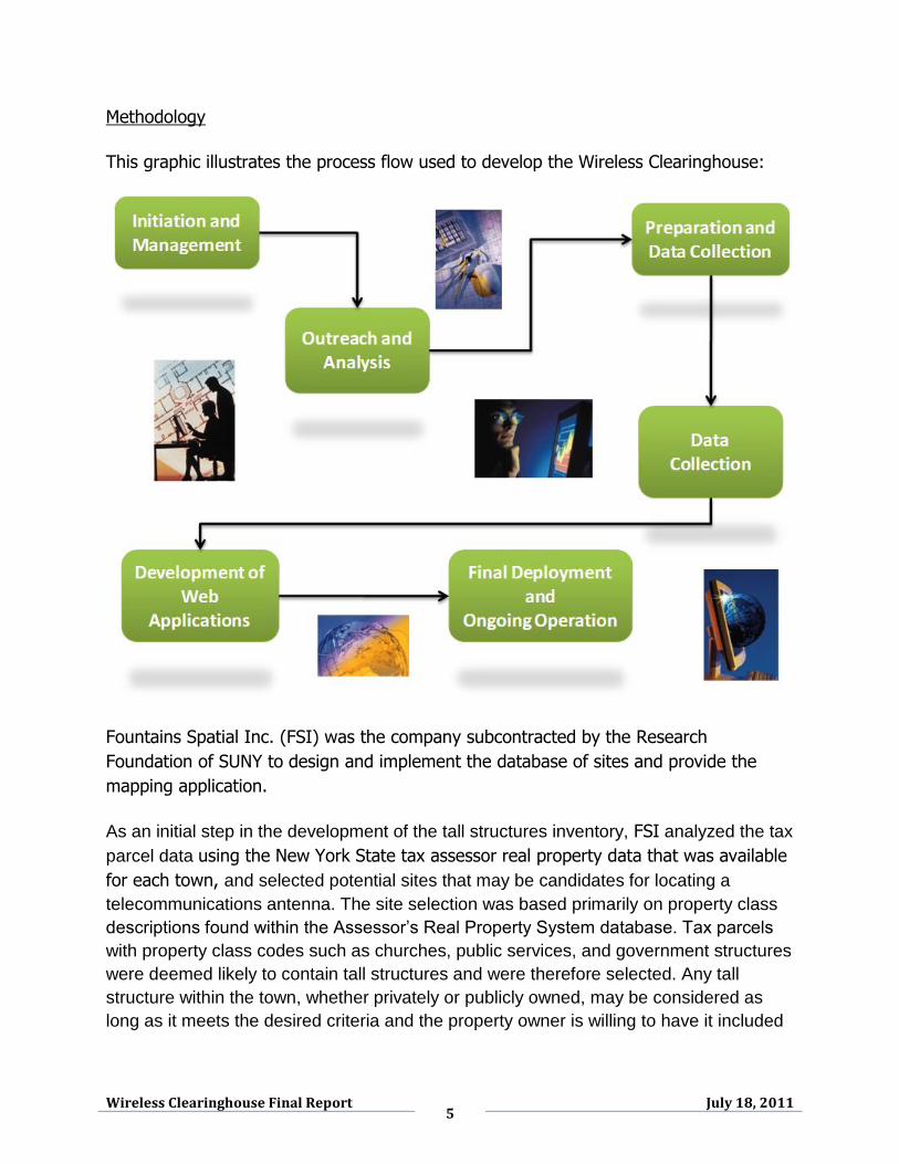
Methodology
This graphic illustrates the process flow used to develop the Wireless Clearinghouse:
Fountains Spatial Inc. (FSI) was the company subcontracted by the Research
Foundation of SUNY to design and implement the database of sites and provide the
mapping application.
As an initial step in the development of the tall structures inventory, FSI analyzed the tax
parcel data using the New York State tax assessor real property data that was available
for each town, and selected potential sites that may be candidates for locating a
telecommunications antenna. The site selection was based primarily on property class
descriptions found within the Assessor’s Real Property System database. Tax parcels
with property class codes such as churches, public services, and government structures
were deemed likely to contain tall structures and were therefore selected. Any tall
structure within the town, whether privately or publicly owned, may be considered as
long as it meets the desired criteria and the property owner is willing to have it included

Wireless Clearinghouse Final Report 6
July 18, 2011
in the inventory. This provided the first group of potentially viable sites, including
publicly owned structures that are often the most accessible to wireless carriers.
Pilot communities
In order to present the most accurate database possible, it was important that the
process for local review and site identification by the towns be reasonably simple and
user friendly. Four towns were invited to serve as pilot communities - reviewing,
revising, and commenting on earlier versions of this site - so that the towns’ input
process could be field tested. Those towns were Brighton, Chester, Long Lake, and
Saranac. Members of the project team met with the town boards of each town to
explain the Wireless Clearinghouse and their role as a pilot community. All of towns
agreed to serve as pilot communities. By early June, each community had reviewed the
database of sites for its town and provided feedback.
• Initially feedback was to be requested from each municipality via survey form
emailed in PDF format.
• Working with the Pilot Communities, it became clear that this process was
somewhat awkward and limited.
• An interactive Municipal Feedback Site was developed based on a customized
version of Google Maps.
• Each municipality has their own login, providing access to potential sites
identified in their community.
• Feedback has been requested to assess the viability of each potential site, refine
site locations, provide supplemental information (e.g., road access, structure
height, etc.), and add additional sites.
Input from the New York State wireless industry
Lowe and Fisher invited three site selection specialists who represent wireless carriers
who provide service in the Adirondack region to review the methodology and criteria for
the Wireless Clearinghouse. Two of these individuals accepted, and conference calls
were held with each of them during which the database was viewed using Google
Maps. Their input was very helpful and their suggestions were incorporated into the
development of the database. Further, Douglas Dimitroff, president of the New York
State Wireless Association, invited Lowe and Fisher to present the project at the New
York State Wireless Association (NYSWA) annual conference in Bolton Landing on May
12, 2011. Subsequent to the conference the NYSWA said: "The Wireless Clearinghouse
is potentially a game changing tool for site selectors to use in seeking existing
transmission sites within the Adirondack Park.”

Wireless Clearinghouse Final Report 7
July 18, 2011
The following criteria are considered important by wireless service providers when
selecting a suitable site, and were provided to the participating towns to use as
guidelines in identifying potential structures:
Existing electrical
Structure height
High site elevation
Easy road access
Good line of sight visibility
Availability to be leased.
In the original Smart Growth grant application, it was proposed that visits would be
made to potential sites to assess their viability, primarily by SUNY Plattsburgh
Geography Department students. This method turned out to be impractical and
unnecessary for the following reasons:
1. New on line resources became available after the grant application was
submitted that allowed the project team to identify many potential sites. This
included National Broadband Map and New York State Broadband Map data.
This supplemented existing data that the Adirondack Park Agency shared with
the project. The Federal Communications Commission was also a source of data
for existing structures used for telecommunications.
2. Fountains Spatial made it possible, through the Google Maps software, for
municipal officials, who best know their communities, to easily review and modify
the preliminary database.
3. The compressed timeline for completing the project did not align well with the
SUNY Plattsburgh academic calendar, making student availability uncertain. For
example, fine tuning the database took place after school ended in May and
June, 2011.
Google Maps was selected by FSI as the application for viewing the site database
because of its versatility and ease of use.
In addition to the four pilot communities, all of the municipalities within the Park were
invited to participate by reviewing pre-selected sites for suitability and submitting
additional sites that may be viable. Efforts were made to identify potential sites in all
municipalities in the Park and, using tax parcel data, sites were identified in 81 of these
municipalities.

Wireless Clearinghouse Final Report 8
July 18, 2011
Municipal officials accessed the site directly and could modify the data for structures in
their town using the innovative Google Maps web application. As of June 30, 2011, 28
towns have participated by reviewing and modifying the structure data (see Appendix
A).
Wireless Clearinghouse Final Report 9
July 18, 2011
Project Objectives
The Wireless Clearinghouse application stated the following:
“The Wireless Clearinghouse is a comprehensive plan with several objectives:
1. Create an inventory of existing structures that are suitable sites for cell phone
and/or wireless broadband antennae and facilities.
2. Develop a plan that identifies suitable transmit sites that also have minimal visual
impact. A key component of the Wireless Clearinghouse strategy is to minimize pressure
to construct new towers.
3. Inform and engage participating Park communities about the relevance and value
of cell phone and wireless Internet services to the economic growth and sustainability
of their communities, including potential revenue opportunities for the municipalities.
4. Improve the capacity of communities to sustain successful economic
development through creation of an asset that will assist with implementation of cell
phone and wireless broadband services. The Wireless Clearinghouse project will create
a web-based, interactive telecommunications resource for all Adirondack Park
communities and agencies, and cellular and wireless service provider companies.”
Each of these objectives was achieved.
Objectives 1 and 2
The first step was identifying and assessing overall availability of wireless service in the
Adirondack Park, and identifying communities that lacked service. This information was
accessible on line from new sources that were not available at the time the Smart
Growth grant application was submitted. These were the U.S. Department of Commerce
National Broadband Mapping Initiative (funded through the American Recovery and
Reinvestment Act of 2009 (ARRA), and New York State’s Critical Infrastructure
broadband mapping resource, also funded by ARRA.
Ideally, comprehensive field surveys would have been conducted to physically identify
all potential structures, but this was impractical due to the compressed timeframe for
the project work, and the unavailability of students, as reported above. However, an
online tool was developed so that local officials, who best know which sites in their
communities are potentially viable, could easily provide input for each site. To create

Wireless Clearinghouse Final Report 10
July 18, 2011
this online tool, Fountains Spatial developed an initial inventory based on tax assessor
information available for each community. These are structures having “promising”
property classes, e.g., schools, churches, water towers, hospitals, municipal buildings.
The point locations for each of these properties, plus privately owned structures, were
available for use in the mapping application. This baseline of existing structures was
augmented with data from the Federal Communications Commission.
Over 1,500 potential sites were identified for all but a few of the towns in the
Adirondack Park.
Objective 3 was accomplished by meeting with the boards of supervisors of four
Adirondack towns, presenting the Wireless Clearinghouse at the 2011 annual meeting
of the Adirondack Association of Towns and Villages, with news releases that were
published in local newspapers and websites, and sent via email messages to each town
supervisor.
Objective 4 was realized through the Wireless Clearinghouse website that can be found
at www.giswebhosting.com/wcmfs.
Feedback from the municipalities was incorporated into a master database.
A publically accessible Wireless Clearinghouse application is ready to be
launched.
This Google Maps application will allow the user to view, query, and filter the
final set of potential sites.
At DEC’s option, the Wireless Clearinghouse Municipal Feedback Site may be left
in place and continuously updated, as changes are made at the local level.

Wireless Clearinghouse Final Report 11
July 18, 2011
Project Communications
Either Lowe or Fish (or both) attended town board of supervisor meetings in Chester,
Brighton, Long Lake, and Saranac to brief the officials about the Wireless Clearinghouse
and to invite their participation as pilot communities.
Informing the New York State wireless industry
Lowe and Fisher demonstrated the Wireless Clearinghouse database and mapping tool
to Douglas Dimitroff, president of the New York State Wireless Association, on April 14,
2011. As a result of this event, Mr. Dimitroff invited Lowe and Fisher to make a
presentation at the New York State Wireless Association’s annual conference in Bolton
Landing on May 12, 2011, a session that Mr. Dimitroff moderated.
Lowe and Fisher also demonstrated the Wireless Clearinghouse to Jeffrey Davis, an
attorney with Hiscock and Barclay, a firm that represents one of the major wireless
carriers in New York State. Mr. Davis provided valuable input on how the Wireless
Clearinghouse could be of greatest use to wireless site location specialists.
Informing Adirondack Park towns
Lowe presented the Wireless Clearinghouse to the annual meeting of the
Association of Adirondack Towns and Villages on June 6, 2011.
ANCA issued news releases in May 2011 that were carried by the Adirondack
Almanac, the Adirondack Express, and the Tug Hill Express. See Appendix D.
ANCA sent two email blasts to municipal officials in May and June, 2011,
informing them about the project and inviting their participation.
ANCA carried articles about the Wireless Clearinghouse in two of its newsletters,
February 3 and May 18, 2011.

Wireless Clearinghouse Final Report 12
July 18, 2011
Conclusion
There are many challenges to expanding broadband access in the Adirondack Park.
The Wireless Clearinghouse, though it has a number of limitations and is not intended
as a single definitive resource for siting telecommunications equipment, provides a
valuable resource in the site identification and review process.
It has been endorsed by the New York State Wireless Association as a useful site
selection tool for companies seeking to provide service in the Adirondack Park.
The Department of Environmental Conservation should consider whether to leave the
website up for public review, and if so, for how long.

Wireless Clearinghouse Final Report 13
July 18, 2011
Appendix A
Adirondack towns that participated in the Wireless Clearinghouse as of June 30, 2011
Arietta
Bellmont
Black Brook
Chester
Dannemora
Edinburg
Fine
Franklin
Hadley
Hope
Horicon
Lewis
Long Lake
Mayfield Village
North Hudson
Ohio
Otter Lake
Parishville
Port Henry Village
Saranac
Speculator Village
Thurman
Ticonderoga
Tupper Lake Village
Warrensburg
Webb
Wells
Willsboro

Wireless Clearinghouse Final Report 14
July 18, 2011
Appendix B
Wireless Clearinghouse email invitation sent to Adirondack municipalities
Dear Town Supervisor:
Please help us gather information about your town for the Adirondack Park
Wireless Clearinghouse project. The purpose of the Wireless
Clearinghouse project is to encourage the expansion of wireless broadband
service in the Park by creating an inventory of existing tall structures that
may be appropriate sites for a telecommunications antenna. The inventory
will be made available online and will be accessible to local communities in
the Park, private telecommunications providers and the public, with the
intent of providing a cost-effective way to assess potential transmission
sites. In addition, the database could be used for emergency services
planning and planning for county-wide projects requiring wireless
capabilities. Preliminary feedback from the wireless industry indicates that
the Wireless Clearinghouse will be a helpful tool in their site selection
process.
We estimate that it will take several hours to complete the information for
your community, and that you will find it time well spent! We suggest that
you gather a handful of people who enjoy working with on line maps and
data to get together to complete this work. We guarantee that it will be an
interesting diversion from your regular work! All municipalities that
participate will be entered into a drawing to receive Fountains Spatial’s new
MuniMapper product, a Google Maps based online parcel viewer application
customized for your community, including web hosting (an approximately
$2,250 value). See this link as an example of how the Town of Canandaigua
uses this service, and please see the attached description for more
information.
We must receive input from your community by June 17. We will publicly
recognize all the communities that provide data for this survey.
The project is funded by a Smart Growth grant to the Town of Saranac from
the Department of Environmental Conservation and is being administered by
The Research Foundation of SUNY and SUNY Plattsburgh, with assistance
from Fountains Spatial, Inc., a Schenectady-based Geographic Information
Systems (GIS) consulting firm and the Adirondack North Country
Wireless Clearinghouse Final Report 15
July 18, 2011
Association. Three communities within the Park – the Towns of Brighton,
Long Lake and Saranac – volunteered as pilot communities for the project
and have already reviewed potential sites and submitted additional sites to
the database. We are now inviting all of the communities within the Park to
participate by reviewing pre-selected sites for suitability and submitting
additional sites that may be suitable.
As an initial step in the development of the tall structures inventory,
Fountains Spatial has analyzed the tax parcel data and selected potential
sites in your community that may be candidates for locating a
telecommunications antenna. The site selection was based primarily on
property class descriptions found within the Assessor’s RPS database. Tax
parcels with property class codes such as churches, public services, and
government structures were deemed likely to contain tall structures and
were therefore selected. Any tall structure within the town, whether
privately or publicly owned, can be considered as long as it meets the
desired criteria and the property owner is willing to have it included in the
inventory.
INSTRUCTIONS
Fountains Spatial has created an online Google Maps viewer which contains
the pre-selected sites for your community. We are asking for your
assistance in reviewing the sites to determine their suitability for locating a
telecommunications antenna. Using the URL, username and password
information below, you may log on to the site to review the data for your
community.
Website: http://giswebhost.org/wcmfs/
Username: (Town name)
Password: (Unique password provided)
When you first login to the website, you will see a list
of undetermined sites for your community in the Table of Contents on the
right hand side of the map. The website uses familiar Google Maps
functionality, and allows you to view terrain maps, street maps, aerial
photography, or view the site in Google Earth. Next to each site, you may
click on the Details link to zoom into the site and get initial information
regarding the site. When you would like to edit the site, click on Edit to

Wireless Clearinghouse Final Report 16
July 18, 2011
open a form where you may provide additional information regarding the
site. Note that the site marker may not fall on the exact location of the
building; if you would like to move the site marker, you may do so easily by
dragging it to a new location with your mouse.
Please take a few minutes to review each site and determine its suitability.
If the structure is not viable for a wireless installation, please specify
it as nonviable, and if possible, provide a reason (structure is not tall, site
does not have easy access, etc). If the structure is considered to be
a viable site, please complete the form to provide any available additional
information about the site (such as presence of electrical power, site
visibility, etc). You may also submit any additional sites that you feel are
viable in your community by selecting a location on the map and completing
a short form with additional information (property owner, type of structure,
etc). The following criteria are considered important by wireless service
providers when selecting a suitable site:
Existing electrical
Tall structure height
High site elevation
Easy site access
Good line of sight visibility
As you review and edit sites, they will move out of
the Undetermined list and into the Nonviable or Viable lists, depending
on how you mark them. You may revisit a site at any time. If you are
unable to complete the entire list of Undetermined sites at one time, the
website will remember your work and you can login and finish your review
later. You may also add sites at any time by following the directions in
the Add section of the table of contents. Please visit the website to view
help videos with more detailed instructions.
We thank you in advance for your participation in this important project.
We must receive input from your community by May 31. When the project is
completed, we will notify you of the launch of the Wireless Clearinghouse
public access website. As you proceed with the review and submission of
sites to the database, please feel free to contact Howard Lowe or me with
any questions or comments, or Jenny Smith for technical support with the
application. Our contact information is below:

Wireless Clearinghouse Final Report 17
July 18, 2011
Jenny Smith
Fountains Spatial, Inc.
137 Jay Street
Schenectady, NY 12305
(518)-346-0942 x19
Howard Lowe
SUNY Plattsburgh
Technical Assistance Center
194 U.S. Oval
Plattsburgh, NY 12901
(518) 564-2214
Sincerely,
Kate Fish
Kate Fish
Executive Director
Adirondack North Country Association 67 Main Street, Suite 201
Saranac Lake, NY 12983
T 518.891.6200
M 518.222.6500
www.adirondack.org
Building Vibrant Rural Communities and Resilient Local Economies

Wireless Clearinghouse Final Report 18
July 18, 2011
Appendix C
Wireless Clearinghouse News Releases
Opportunity to expand broadband service in the region
Wireless Mapping Project
Seeks Communities' Participation
FOR IMMEDIATE RELEASE
May 11, 2011 - Adirondack towns and villages have a unique
opportunity to be included in an exciting project that seeks
to improve wireless cell and broadband availability in the
Adirondack Park. But they must act now!
The goal of the Wireless Clearinghouse project is to create an
inventory of existing structures in Adirondack Park towns that
are suitable for housing a wireless antenna. The database will
be a resource for private wireless companies, with the goal of
encouraging them to expand wireless telecommunications
across the region, a key to economic development. The
inventory produced will be a significant planning asset that will
be available through a secure website and will feature a GIS
database with maps and images.
Right now, municipal officials are being asked to respond to an email sent by the Adirondack North
Country Association (ANCA) that contains instructions for listing their community's structures in the
online inventory. All communities who provide feedback by May 31 will be publicly acknowledged
when the final results of the project are published and will be entered in a drawing to win a free
customized online mapping application.
Fountains Spatial Inc., a GIS consulting firm based in Schenectady, has been contracted by SUNY
Plattsburgh and ANCA with project methodology, data collection, and development of an interactive
web-map application to access the data collected in the project.
The data being collected this month will identify existing tall structures within Adirondack
Park municipalities, such as churches, water towers, and other tall structures. To start, Fountains
Spatial combed tax parcel data for information on property class codes such as churches, public
services and government structures that could be considered suitable sites for a telecommunications
antenna. The State's new broadband mapping tool has also been a big help.
The project is due to be completed this summer. In the process, one of the goals is to inform community

Wireless Clearinghouse Final Report 19
July 18, 2011
leaders of the opportunities provided by these technologies.
"DEC, SUNY Plattsburgh, Fountains Spatial and ANCA hope that the Wireless Clearinghouse database
will encourage wireless carriers to provide service in additional Park communities. People today want to
stay connected 24/7 using their mobile device or computer, and better wireless service will support
municipal services, and benefit year round and seasonal residents, and visitors may stay longer," said
Howard Lowe, project manager.
Project partners are the Town of Saranac, SUNY Plattsburgh, Fountains Spatial and ANCA. The
Wireless Clearinghouse project is funded by a Department of Environmental Conservation Smart
Growth grant.
Adirondack North Country Association
Melissa Hart
Communications Specialist
(518) 891-6200
SUNY Plattsburgh
Howard Lowe
Assessment & Data Manager
(518) 564-2257

Wireless Clearinghouse Final Report 20
July 18, 2011
Appendix D
Wireless Clearinghouse articles in three newspapers
Adirondack Express and the Tug Hill Express, May 17, 2011
Wireless mapping project needing participation from the community
Adirondack towns and villages have a unique opportunity to be included in an exciting project
that seeks to improve wireless cell and broadband availability in the Adirondack Park.
The goal of the Wireless Clearinghouse project is to create an inventory of existing structures in
Adirondack Park towns that are suitable for housing a wireless antenna. The database will be a
resource for private wireless companies, with the goal of encouraging them to expand wireless
telecommunications across the region, a key to economic development. The inventory produced
will be a significant planning asset that will be available through a secure website and will
feature a GIS database with maps and images.
Right now, municipal officials are being asked to respond to an email sent by the Adirondack
North Country Association (ANCA) that contains instructions for listing their community’s
structures in the online inventory. All communities who provide feedback by May 31 will be
publicly acknowledged when the final results of the project are published and will be entered in a
drawing to win a free customized online mapping application.
Fountains Spatial Inc., a GIS consulting firm based in Schenectady, has been contracted by
SUNY Plattsburgh and ANCA with project methodology, data collection, and development of an
interactive web-map application to access the data collected in the project.
The data being collected this month will identify existing tall structures within Adirondack Park
municipalities, such as churches, water towers, and other tall structures . To start, Fountains
Spatial combed tax parcel data for information on property class codes such as churches, public
services and government structures that could be considered suitable sites for a
telecommunications antenna. The State’s new broadband mapping tool has also been a big help.
The project is due to be completed this summer . In the process, one of the goals is to inform
community leaders of the opportunities provided by these technologies.
“DEC, SUNY Platts-burgh, Fountains Spatial and ANCA hope that the Wireless Clearinghouse
database will encourage wireless carriers to provide service in additional Park communities.
People today want to stay connected 24/7 using their mobile device or computer, and better

Wireless Clearinghouse Final Report 21
July 18, 2011
wireless service will support municipal services, and benefit year round and seasonal residents,
and visitors may stay longer,” said Howard Lowe, project manager .
Project partners are the Town of Saranac, SUNY Plattsburgh, Fountains Spatial and ANCA. T he
Wireless Clearinghouse project is funded by a Department of Environmental Conservation Smart
Growth grant.

Wireless Clearinghouse Final Report 22
July 18, 2011
Monday, May 16, 2011
Potential Adirondack Wireless Locations Sought
by The Almanack Staff
Adirondack towns and villages have a unique opportunity to be included in a project that seeks to
improve wireless cell and broadband availability in the Adirondack Park.
The goal of the Wireless Clearinghouse project is to create an inventory of existing structures in
Adirondack Park towns that are suitable for housing a wireless antenna. The database will be a
resource for private wireless companies, with the goal of encouraging them to expand wireless
telecommunications across the region, a key to economic development. The inventory produced
is expected to be a significant planning asset available through a secure website and featuring a
GIS database with maps and images.
Right now, municipal officials are being asked to respond to an email sent by the Adirondack
North Country Association (ANCA) that contains instructions for listing their community's
structures in the online inventory. All communities who provide feedback by May 31 will be
publicly acknowledged when the final results of the project are published and will be entered in a
drawing to win a free customized online mapping application.
Fountains Spatial Inc., a GIS consulting firm based in Schenectady, has been contracted by
SUNY Plattsburgh and ANCA with project methodology, data collection, and development of an
interactive web-map application to access the data collected in the project.
The data being collected this month will identify existing tall structures within Adirondack Park
municipalities, such as churches, water towers, and other tall structures. To start, Fountains
Spatial combed tax parcel data for information on property class codes such as churches, public
services and government structures that could be considered suitable sites for a
telecommunications antenna.
The project is due to be completed this summer. In the process, one of the goals is to inform
community leaders of the opportunities provided by these technologies.
"DEC, SUNY Plattsburgh, Fountains Spatial and ANCA hope that the Wireless Clearinghouse
database will encourage wireless carriers to provide service in additional Park communities.

Wireless Clearinghouse Final Report 23
July 18, 2011
People today want to stay connected 24/7 using their mobile device or computer, and better
wireless service will support municipal services, and benefit year round and seasonal residents,
and visitors may stay longer," said Howard Lowe, project manager.