THE SIRENA CRUISE
51
Cruise report 1 SIRENA 2 / D274 Cruise RRS Discovery Govan, Sept, 12 th – Ponta Delgada, Oct, 1 st , 2003 ---------------------------------------------------------------------------------------------------------------------- THE SIRENA 2 / D274 CRUISE RRS Discovery Govan (Scotland), September, 12 th , 2003 Ponta Delgada (Azores), October, 1 st , 2003 Cruise Report Preliminary version Compiled on board RSS Discovery by J. Goslin, Principal Scientist Last edited : Dec, 9th , 2003 UMR 6538 “Domaines Océaniques” Institut Universitaire Européen de la Mer Université de Bretagne Occidentale
Transcript of THE SIRENA CRUISE

Cruise report 1SIRENA 2 / D274 Cruise RRS Discovery Govan, Sept, 12th – Ponta Delgada, Oct, 1st, 2003 ----------------------------------------------------------------------------------------------------------------------
THE SIRENA 2 / D274 CRUISE
RRS Discovery
Govan (Scotland), September, 12th, 2003Ponta Delgada (Azores), October, 1st, 2003
Cruise Report
Preliminary version
Compiled on board RSS Discovery by J. Goslin, Principal Scientist
Last edited : Dec, 9th , 2003
UMR 6538 “Domaines Océaniques”Institut Universitaire Européen de la Mer
Université de Bretagne Occidentale

Cruise report 2SIRENA 2 / D274 Cruise RRS Discovery Govan, Sept, 12th – Ponta Delgada, Oct, 1st, 2003 ----------------------------------------------------------------------------------------------------------------------
29880 Plouzané - France
Report summary
- Avant-propos Foreword page 3
- Remerciements page 4
- Acknowledgments page 5
- I - General scientific objectives of the SIRENA cruise page 6
- I - 1 rationale for the deployment of autonomous hydrophones page 7- I - 2 along-track data recorded along the transits page 10
- II - List of participants page 11
- III – Cruise operations: page 12
- III - 1 short cruise log page 12- III - 2 the PMEL/NOAA autonomous hydrophones page 16- III - 3 recovery particulars page 16
- IV - Along-track data page 23
- IV - 1 the “Terceira survey” page 23- IV - 2 other along-track data page 24- IV - 3 data processing page 24
- V – Preliminary results from the interpretation of the Sirena page 31network data
- Appendix: line plots of along-track data page 32

Cruise report 3SIRENA 2 / D274 Cruise RRS Discovery Govan, Sept, 12th – Ponta Delgada, Oct, 1st, 2003 ----------------------------------------------------------------------------------------------------------------------
Avant- propos Foreword
La campagne SIRENA 2 /D274 est le résultat d’une coopération internationale entre deslaboratoires de trois pays, qui ont collaboré dès les premières étapes de la préparation du projetSIRENA en 2000 et dont des membres ont participé à la campagne Sirena en 2002, au cours delaquelles les hydrophones avaient été mouillés:
• les laboratoires UMR6538/CNRS à Brest; le Laboratoire de Géosciences Marines de l ’IPGParis, en France;
• le PMEL/NOAA, à Newport, Oregon aux Etats-Unis;• le Centre de Géophysique Marine de l ’Université de Lisbonne (CGUL) et l ’Université de
l’Algarve à Faro, au Portugal.
La plupart de nos collègues étrangers participant au projet maîtisent bien le Français.
Nous avons cependant préféré rédiger ce rapport en Anglais, ce qui permettait d’y incluredirectement les contributions de nos collègues américains et nous laisse espérer qu’il sera ainsiplus complètement compris de l ’ensemble des membres de l’équipe du projet SIRENA et despersonnes extérieures à cette équipe qui souhaiteraient en prendre connaissance.
Enfin, la campagne Sirena 2 /D274 ayant été réalisée à bord du navire britannique RRS Discovery,dans le cadre de l’Accord Tripartite d’échange de temps bateau entre la France, la GrandeBretagne et l ’Allemagne, nous ne pouvions faire moins que de rendre ce rapport lisible par lespersonnes du NERC, du RSU et de l’UKORS qui souhaiteraient en prendre connaissance.
--------------------------------
The planning and achievement of the SIRENA 2 /D74 cruise are the result of a cooperationbetween labs from three countries. These labs have been collaborating since the initiation of theSIRENA project in 2000 and had sent people on board Le Suroit for the 2002 deployment cruise.These labs are:
• the UMR6538/CNRS in Brest; the Marine Geosciences Lab of IPG, France;• the PMEL/NOAA, at Newport, Oregon, United States;• the Centre for Geophysics of the University of Lisbon (CGUL) and the University of Algarve at
Faro, Portugal.
Most of our foreign colleagues which participate in the Sirena project get along quite well withFrench.
It was however considered preferable to write up most of this report in English, as it will so moreeasily include the contribution of the US members of the scientific party and in the hope that it willbe more fully understandable by all the members of the SIRENA Project Team and by variouspersons who might want to read it!
Finally, as the Sirena 2 /D274 cruise was sailed on the British ship RRS Discovery, in theframework of the Tripartite Agreement for ship-time exchange signed by France, Great Britain andGermany., the least we could do was to make this report understandable to those from NERC, RSUand UKORS who would be interested in reading it!

Cruise report 4SIRENA 2 / D274 Cruise RRS Discovery Govan, Sept, 12th – Ponta Delgada, Oct, 1st, 2003 ----------------------------------------------------------------------------------------------------------------------
Remerciements
L’équipe scientifique embarquée sur le Discovery pour la campagne SIRENA 2 / D274 tient àremercier le Commandant Robin Plumley, les officiers et l ’équipage pour leur efficacité et leurdisponibilité lors de la conduite des différentes opérations à la mer menées durant la campagne.
En particulier, l ’équipage de pont a réalisé très rapidement la récupération des mouillages
Nos remerciements vont également à l ’équipe technique embarquée des ingénieurs de l ’UKORS:
- les deux Robs et Jez ont conçu et réalisé en un temps record, un enrouleur qui a grandementfacilité et rendu plus rapide l’enroulage des mouillages sur les tourets en bois; le dicton(librement adapté) “le besoin créé l’organe” s’est donc avéré particulièrement exact lors de lacampagne…
- Paul, adepte inconditionnel de Linux, a permis aux ordinateurs variés apportés par l ’équipescientifique (même ceux qui tournaient sous diverses variantes de Windoze …) de communiquerrapidement à travers le réseau. Il nous permis d’avoir un accès facile aux données acquisesen route, afin de les visualiser. Enfin, il nous a fourni un moyen supplémentaire (DLT)d’archiver les données des hydrophones.
Des financements de différentes provenances ont permis la réalisation de la campagne Sirena:
- le coût de fonctionnement du navire a été assuré par le Ministère de la Recherche, suite àl’évaluation favorable du projet en 2002 par le Comité Géosciences Marines;
- les coûts de développement, de construction et de mise en oeuvre des hydrophonesautonomes ont été couverts par le Pacific Marine Environmental Laboratory de la NOAA;
- les salaires et les frais de missions des membres de l ’équipe scientifique ont été payés parleurs pays respectifs (l ’Institut National des Sciences de l ’Univers et de l’EnvironnementINSUE a pris en charge ceux des participants français).
Cruise report 5SIRENA 2 / D274 Cruise RRS Discovery Govan, Sept, 12th – Ponta Delgada, Oct, 1st, 2003 ----------------------------------------------------------------------------------------------------------------------
Acknowledgments
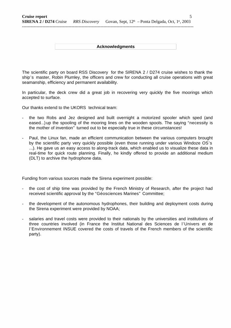
The scientific party on board RSS Discovery for the SIRENA 2 / D274 cruise wishes to thank theship’s master, Robin Plumley, the officers and crew for conducting all cruise operations with greatseamanship, efficiency and permanent availability.
In particular, the deck crew did a great job in recovering very quickly the five moorings whichaccepted to surface.
Our thanks extend to the UKORS technical team:
- the two Robs and Jez designed and built overnight a motorized spooler which sped (andeased…) up the spooling of the mooring lines on the wooden spools. The saying “necessity isthe mother of invention” turned out to be especially true in these circumstances!
- Paul, the Linux fan, made an efficient communication between the various computers broughtby the scientific party very quickly possible (even those running under various Windoze OS’s… ). He gave us an easy access to along-track data, which enabled us to visualize these data inreal-time for quick route planning. Finally, he kindly offered to provide an additional medium(DLT) to archive the hydrophone data.
Funding from various sources made the Sirena experiment possible:
- the cost of ship time was provided by the French Ministry of Research, after the project hadreceived scientific approval by the “Géosciences Marines” Committee;
- the development of the autonomous hydrophones, their building and deployment costs duringthe Sirena experiment were provided by NOAA;
- salaries and travel costs were provided to their nationals by the universities and institutions ofthree countries involved (in France the Institut National des Sciences de l ’Univers et del’Environnement INSUE covered the costs of travels of the French members of the scientificparty).

Cruise report 6SIRENA 2 / D274 Cruise RRS Discovery Govan, Sept, 12th – Ponta Delgada, Oct, 1st, 2003 ----------------------------------------------------------------------------------------------------------------------
I – General objectives of the SIRENA cruise
The general objectives of the Sirena experiment have been described in the SIRENA 2002deployment cruise report.
They will be only summarized below, as the report can be:
- downloaded through a link from http://www-sdt.univ-brest.fr/~goslin/SIRENA
- or directly read from http://www-sdt.univ-brest.fr/~goslin/SIRENA/REPT/
Previous cruises on the “Azores hotspot/ridge interactions factory”
Many cruises, ran by various universities or institutions, were devoted in the recent years to studythe accretion processes along the Mid-Atlantic Ridge, along a section where this Ridge interactswith the Azores plume. All these cruises (to the exception of the TRIATNORD cruise; see e.g.Goslin et al., 1999) were aimed at sections of the Ridge south of the Azores. Moreover, none ofthese cruises included the study of the upper mantle structure in a slow ridge/hotspot interactioncontext as one of its objectives.
All of these cruises were part of the “hotspot-ridge interactions” initiatives set within national(such as “Dorsales” in France, “Ridge” in the US) or international (“InterRidge”) ridge-studyprograms. This area of research has been – and still is - very active in the international ridgecommunity and numerous symposia were devoted to it in international meetings (AGU, EUG, AGS).
The autonomous hydrophone technology
The PMEL/NOAA has been developing the technology of mooring autonomous hydrophones in theSOFAR channel for several years now and has deployed them successfully since 1996, in theEastern Equatorial Pacific, Central Atlantic, Gulf of Alaska and Mariana Basin. These deploymentshave proved the great efficiency of the haruphones for precisely locating low-magnitudeearthquakes which occur at active spreading centers.
A preliminary interpretation of the Sirena data (see below section V ) confirmed that the networkwas able to record as much as 30 times more earthquakes occurring along the MAR than wererecorded by the land stations of global seismic networks.
For further details on autonomous technology and use, please link to the web sites:
http://www.pmel.noaa.gov/vents/acoustics/seismicity/epr/epr_seis.html
http://www.pmel.noaa.gov/vents/acoustics/haru_system.html
and refer to the papers listed below (the names of the Sirena project members are printed inboldface):
Dziak, R.P. (2001): Empirical relationship of T-wave energy and fault parameters of northeast Pacific Oceanearthquakes. Geophys. Res. Lett., 28, 2537-2540.
Dziak, R.P., and C.G. Fox (1999): Long-term seismicity and ground deformation at Axial Volcano, Juan de Fuca Ridge.Geophys. Res. Lett., 26(24), 3641-3644.
Dziak, R.P., and C.G. Fox (1999): The January 1998 earthquake swarm at Axial Volcano, Juan de Fuca Ridge:Hydroacoustic evidence of seafloor volcanic activity. Geophys. Res. Lett., 26(23), 3429-3432.
Dziak, R.P., C.G. Fox, R.W. Embley, J.L. Nabelek, J. Braunmiller, and R.A. Koski (2000): Recent tectonic of the BlancoRidge, Eastern Blanco Transform Fault Zone. Mar. Geophys. Res., 21(5), 423-450.

Cruise report 7SIRENA 2 / D274 Cruise RRS Discovery Govan, Sept, 12th – Ponta Delgada, Oct, 1st, 2003 ----------------------------------------------------------------------------------------------------------------------Fox, C.G. (2000): U.S. NOAA underwater acoustic environmental monitoring efforts. Proceedings of the Fifth European
Conference on Underwater Acoustics, ECUA2000, M.E. Zakharia, P. Chevret, and P. Dubail (eds.), Lyon, France,2000, 749-754.
Fox, C.G., and R.P. Dziak (1999): Internal deformation of the Gorda Plate observed by hydroacoustic monitoring. J.Geophys. Res., 104(B8), 17,603-17,615.
Fox, C. G., Matsumoto, H. and Lau, T.K.A (2001): Monitoring pacific Ocean seismicity from an autonomous hydrophonearray. J. Geophys. Res., 106, 4183-4206.
Johnson, H.P., H. Hutnak, R.P. Dziak, C.G. Fox, I. Urcuyo, C. Fisher, J.P. Cowen, and J. Nabelek (2000): Earthquake-induced changes in a hydrothermal system at the Endeavour Segment; Juan de Fuca Ridge. Nature, 407, 174-177.
Orcutt, J., E. Bernard, C.-S. Chiu, C. Collins, C. deGroot-Hedlin, R. Dziak, C. Fox, W. Hodgkiss, W., Kuperman, J.Mercer, W. Munk, R. Odom, M. Park, D. Soukup, R. Spindel, F. Vernon, and P. Worcester (2000): Long-termobservations in acoustics. The Ocean Acoustic Observatory Federation. Oceanography, 13(2), 57-63.
Slack, P.D., C.G. Fox, and R.P. Dziak (1999): P wave detection thresholds, Pn velocity estimates, and T wave locationuncertainty from oceanic hydrophones. J. Geophys. Res., 104(B6), 13,061-13,072.
I-I Rationale for the deployment of autonomous hydrophones
Six haruphones were deployed in the SOFAR channel in the North Atlantic during the SIRENAcruise (see the general track map in section III for the locations of the mooring sites and for trackssailed during the Sirena1 & Sirena2/D274 cruises). At water depths around 1000 meters, acousticwaves generated in the water column by earthquakes – and by marine mammals - propagate tovery long distances with a very low signal attenuation. The moorings are located on both flanks ofthe Mid-Atlantic Ridge (MAR), north of the Azores, between latitudes 40°N and 50.5°N (that isbetween the Azores Plateau and a major structural discontinuity south of the Gibbs Fracture Zone).
An other hydrophone network, similar to the one which was deployed during the SIRENAcruise, has been deployed south of the Azores by the PMEL/NOAA between latitudes 17°N and35°N. This network has been operating since Feb. 99 and funding for its operation goes on till2006.
It should be noted in this respect that the Azores Plateau is globally shallower than the
SOFAR channel in the North Atlantic, especially as the apex of the SOFAR channel was found to beunusually deep in the area of survey, exceeding 1000 meters at some of the mooring sites. Ittherefore acts as a "barrier" to the sound propagation of the acoustic waves generated byearthquakes whose epicenters are located south of the Plateau. The existence of such a barrierexplains that the network which is presently operated by PMEL/NOAA can observe only very few ofthe events which originate north of the Azores Plateau. This problem is the main reason whichwarranted the SIRENA experiment.
The SIRENA experiment objectives (two main objectives and an ancillary one) are based onan accurate determination of the epicenters of the numerous earthquakes occurring along the Mid-Atlantic Ridge. Such a precise determination is not achieved by global seismograph networks,which record 30 to 50 times less numerous earthquakes and fail to locate most of the events with asufficient accuracy. Such goals (the recording of numerous low-magnitude earthquakes and theprecise determination of their locations) are made possible by the data recorded by the hydrophonenetwork.
The objectives are the following:
I.I.1 - To contribute to the understanding of active processes at the axis of mid-oceanicridges.
Recent studies of the accretion processes active at the axes of slow ridges, whether based onfield studies (e.g. Thibaud et al., 1998) or on the interpretation on analog or numerical models (e.g.

Cruise report 8SIRENA 2 / D274 Cruise RRS Discovery Govan, Sept, 12th – Ponta Delgada, Oct, 1st, 2003 ----------------------------------------------------------------------------------------------------------------------Mauduit & Dauteuil, 1996) have promoted the now well-accepted image that spreading results froma succession, in time and space, of magmatic and tectonic episodes.
If confirmed, such time- and space-variations in the magmatic activity along the axis of theridge will bear direct consequences on the rheology of the lithosphere and crust, influencing in turnthe stress regime and the distribution of deformation, which would be therefore also variable withtime and space (see e.g. Dauteuil & Brun, 1996 ; Thibaud et al., 1999).
The above hypotheses, mainly derived from structural and petrological observations, await tobe confirmed “directly” by geophysical arguments. In particular, the spatial distribution of activefaults remains largely an open question, awaiting for a direct observation of seismicity at thesegment’s scale. Moreover, while field observations allow to localize the faults and to quantify theirtotal displacement, they bring only indirect arguments on their present activity. Finally, the period ofrecurrence of magmatic episodes which occur at segment centers along slow-spreading ridges islargely unknown (for example, a single episode was observed by the south Azores network during athree-year period, at the Lucky Strike site. Was the MAR exceptionally active? Or exceptionallyquiet? During this period).
Unfortunately, the low magnitude earthquakes occurring at the axes of active ridges, whichwould contribute to answering the above questions, very often escape detection by landseismological stations, located too far away from the epicenter locations. It is therefore very difficult(if not outright impossible) to relate epicenter locations provided by global networks to ridge features(even to the major ones such as active segments, transform and non-transform axis discontinuities).
I.I-.2 - To get some insight into ridge / hotspot interaction processes in the uppermantle
Global tomography models, derived from the inversion of teleseismic data recorded at landstations belonging to global networks, represent the only direct information on the distribution ofseismic velocities (and hence, of densities and temperature) in the upper mantle. Unfortunately,global models (e.g. those of Ritsema et al., 1999 or of Mégnin & Romanowicz, 2000) do not providea sufficient horizontal resolution for the upper mantle (their resolution is less than 1000 km fordepths shallower than 150 km, and they are not reliable at all in the first 50 km).
The need therefore remains for high-resolution tomographic models of the upper mantle,allowing to characterize heterogeneities in the upper mantle (uppermost 200 km) at the segment’sscale, under the recent domain of the North Atlantic north of the Azores.
The inversion of travel-time anomalies of the first arrivals of seismic waves, generated byearthquakes which occur at the mid-Atlantic Ridge axis and recorded by distant land stations,should allow to make significant progress towards the computation of a regional high-resolutionmodel of the upper mantle. A preliminary work has been conducted at UMR6538 (DEA A. Kielius,2000) to obtain such a model under the North Atlantic. Unfortunately, inverting land station travel-time anomaly data simultaneously for the epicenter location and for the upper mantle velocitystructure, rapidly degrades the resolution of the latter.
Precisely-located epicenters might therefore improve the reliability of the inversion in terms ofupper mantle structure, as no location errors would then be built in the inversion. Such a high-resolution model would certainly be a major advance towards the understanding of ridge-hotspotinteraction processes active in the upper mantle.
This objective nevertheless requires a long-term deployment of the hydrophone network, asonly fifteen major earthquakes (magnitude > 5.0) are reported in the NEIC catalog as havingoccurred between the Azores and Iceland during the deployment of the Sirena network.

Cruise report 9SIRENA 2 / D274 Cruise RRS Discovery Govan, Sept, 12th – Ponta Delgada, Oct, 1st, 2003 ----------------------------------------------------------------------------------------------------------------------
I.I.3 - By observing the variability of along-ridge seismicity with ti menorth of the Azores andby comparing it to the seismicity observed within the Azores archipelago itself, to contribute to theassessment of the seismic hazard in the Azores archipelago.
Bell, R.E. & Buck, R.W., 1992. Crustal control of ridge segmentation inferred from observations of the Reykjanes Ridge.Nature, 357, 583-586.
Bohnenstiehl, D.R., Tolstoy, M., Smith, D.K., Fox, C.G., and Dziak, R.P. , 2003. Time clustering behaviour of earthquakesalong the Mid-Atlantic Ridge 15°-35°N: Observations from hydroacoustic monitoring. Phys. Earth Planet. Int., 138,147-161.
Bohnenstiehl, D.R., Tolstoy, Dziak, R.P. Fox, C.G. and Smith, D.K., 2003. Aftershock sequences in the mid-ocean ridgeenvironment: an analysis using hydroacoustic data. Tectonophysics, 354, 49-70.
Cannat, M., 1996. How thick is the magmatic crust at slow-spreading ridges ? J. Geophys .R., 101, 2847-2857.
Dauteuil, O. & Brun, J.-P., 1996. Deformation partitioning in a slow-spreading ridge undergoing oblique extension (MohnsRidge, Norwegian Sea). Tectonics, 15, 870, 884.
Dosso, L., Bollinger, C., Etoubleau, J., Bougault, H. & Goslin, J., 2000 - géochimie de la dorsale médio-atlantique aunord des Açores (40°-45°N). RST Paris, 17-20 avril 2000.
Durand, C., Gente, P. & Dauteuil, O., 1995. Caractéristiques morphologiques des segments axiaux de la Dorsale Médio-Atlantique. C. R. Acad. Sci. Paris, 320, 411-418.
Goslin, J. & the TRIATNORD Scientific Party, 1999 - Extent of Azores plume influence on the Mid-Atlantic Ridge north ofthe hotspot. Geology, 27, 991-994.
Goslin, J. , Thirot, J.-L., Noel, O. and Francheteau, J., 1998. Slow-ridge / hotspot interactions from global gravity, seismictomography and 87Sr / 86Sr isotope data. Geophys. J. Int., 135, 700-710.
Kielius, A., 2000. Structure thermique de la lithosphère et du manteau supérieur sous la dorsale médio-Atlantique déduitede l'analyse des temps de trajets des ondes sismiques (application à la zone TRIATNORD au nord des Açores).U.B.O. juin 2000.
Kong, L. S., Solomon, S.C. & Purdy, G.M., 1992. Microeartquake characteristics of a mid-ocean ridge along-axis high. J.Geophys. R., 97, 1659-1697.
Magde, S.G., Sparks, D.W. & Detrick, R.S., 1997. The relation between buoyant mantle flow, melt migration, and gravitybull's eyes at the Mid-Atlantic Ridge between 33°N and 35°N. Earth Planet . Sci. Lett., 148, 59-67.
Mauduit, T. & Dauteuil, O., 1996. Small-scale models of oceanic transform zones. J. Geophys. Res., 101, 20195-20209.
Mégnin, C. & Romanowicz, B., 2000. The three-dimensional shear velocity structure of the mantle from the inversion ofbody, surface and higher-mode waveforms. Geophys. J. Int., 143, 709-728.
Ritsema, J., Van Heijt, H.J. & Woodhouse, J.H., 1999. Complex shear wave velocity structure imaged beneath Africa andIceland. Science, 286, 1925-1928.
Silveira, G., Stutzmann, E., Griot, D.-A., Montagner, J.-P. & Mendes Victor, L., 1998. Anisotropic tomography of theAtlantic Ocean from Rayleigh surface waves., Phys. Earth Planet. Int., 106, 257-273.
Smith, D.K., Tolstoy, M., Fox, C.G., Bohnenstiehl, D.R., Matsumoto, H. and Fowler, M.J. , 2002. Hydroacousticmonitoring of seismicity at the slow-spreading Mid-Atlantic Ridge. Geophys. Res. Lett., 29, 13-1:13-4.
Thibaud, R., Dauteuil, O. & Gente, P., 1999. Faulting pattern along slow-spreading ridge segments : a consequence ofalong-axis variation in lithospheric morphology. Tectonophysics, 312, 157-174.
Thibaud, R., Gente, P. & Maia, M., 1998. A systematic analysis of the Mid-Atlantic Ridge morphology and gravity between15°N and 40°N : constraints on the thermal structure. J. Geophys. R., 103, 24223-24243.
Tisseau, C. & Tonnerre, T., 1995. Non steady-state of spreading ridges : implications for melt generation and mantleoutcrops. In : Mantle and lower crust exposed in ridges and ophiolites. Vissers, R.L.M. & Nicolas, A., eds. KluwerAcad. Press, 181-214.
Toomey, D.R., Solomon, S.C. & Purdy, G.M., 1988. Microearthquakes beneath the median valley of the Mid-AtlanticRidge near 23°N : tomography and tectonics. J. Geophys. Res., 93, 9093-9112.
Finally, the hydrophones have also recorded the sounds produced by large marine mammals,thus allowing to evaluate the distribution between various species of whales and to locate majorwhale herds. This piggy-back experiment on SIRENA is conducted by PMEL, in cooperation withthe University of the Azores at Ponta Delgada, as part as an environmental monitoring program ofmarine mammals in the world’s oceans.
Cruise report 10SIRENA 2 / D274 Cruise RRS Discovery Govan, Sept, 12th – Ponta Delgada, Oct, 1st, 2003 ----------------------------------------------------------------------------------------------------------------------
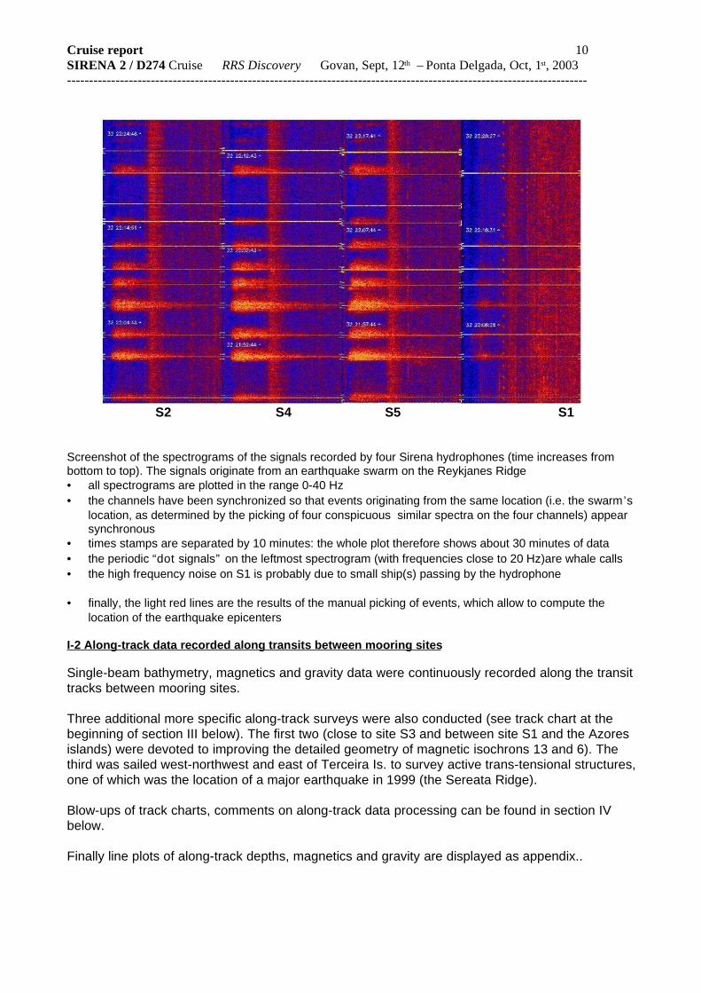
S2 S4 S5 S1
Screenshot of the spectrograms of the signals recorded by four Sirena hydrophones (time increases frombottom to top). The signals originate from an earthquake swarm on the Reykjanes Ridge• all spectrograms are plotted in the range 0-40 Hz• the channels have been synchronized so that events originating from the same location (i.e. the swarm’s
location, as determined by the picking of four conspicuous similar spectra on the four channels) appearsynchronous
• times stamps are separated by 10 minutes: the whole plot therefore shows about 30 minutes of data• the periodic “dot signals” on the leftmost spectrogram (with frequencies close to 20 Hz)are whale calls• the high frequency noise on S1 is probably due to small ship(s) passing by the hydrophone
• finally, the light red lines are the results of the manual picking of events, which allow to compute thelocation of the earthquake epicenters
I-2 Along-track data recorded along transits between mooring sites
Single-beam bathymetry, magnetics and gravity data were continuously recorded along the transittracks between mooring sites.
Three additional more specific along-track surveys were also conducted (see track chart at thebeginning of section III below). The first two (close to site S3 and between site S1 and the Azoresislands) were devoted to improving the detailed geometry of magnetic isochrons 13 and 6). Thethird was sailed west-northwest and east of Terceira Is. to survey active trans-tensional structures,one of which was the location of a major earthquake in 1999 (the Sereata Ridge).
Blow-ups of track charts, comments on along-track data processing can be found in section IVbelow.
Finally line plots of along-track depths, magnetics and gravity are displayed as appendix..

Cruise report 11SIRENA 2 / D274 Cruise RRS Discovery Govan, Sept, 12th – Ponta Delgada, Oct, 1st, 2003 ----------------------------------------------------------------------------------------------------------------------
II – List of participants
SIRENA 2 / D274 Scientific party
GOSLIN [email protected]
geophysics UMR CNRS 6538 DomainesOcéaniques - Brest
BAZIN [email protected]
geophysics/seismology Lab. Géosciences Marines, IPG Paris& Observatoire Volcanologique de laGuadeloupe
FOWLER [email protected]
hydrophone technology PMEL/NOAA Newport (Oregon)
LOURENCO [email protected]
qeophysics/tectonics CGUL Univ. Lisbon & CIMA Univ. ofAlgarve (Faro)
LUIS [email protected]
geophysics CIMA, Univ. of Algarve (Faro)
MARTIN [email protected]
computer engineer UMR CNRS 6538 DomainesOcéaniques - Brest
PERROT [email protected]
geophysics/seismology UMR CNRS 6538 DomainesOcéaniques - Brest
ROYER [email protected]
geophysics UMR CNRS 6538 DomainesOcéaniques - Brest
UKORS Shipboard Team
BROWN Rob EngineerDUNCAN Paul Computer engineerEVANS Jez Engineer McLACHLAN Rob Engineer
CREW members
Robin PLUMLEY MasterDerek NODEN Chief OfficerJohn MITCHELL 2nd OfficerAndy KIRKALDY-WILLIS 3rd OfficerStephen MOSS Chief EngineerJohn HOLT 2nd EngineerAnthony HEALY 3rd EngineerGary SLATER 3rd EngineerPhilip PARKER ETOBrian WARES CadetMichael DRAYTON CPOD
Thomas LEWIS PODStewart BARRETT SG1AStephen DAY SG1APerry DOLLERY SG1AStephen SMITH SG1AJohn SMYTH MMIAEdward STAITE SCMPaul LUCAS Chef Walter LINK Assistant ChefJames NUGENT StewardMichael TREVASKIS ExCPO(D)
Cruise report 12SIRENA 2 / D274 Cruise RRS Discovery Govan, Sept, 12th – Ponta Delgada, Oct, 1st, 2003 ----------------------------------------------------------------------------------------------------------------------
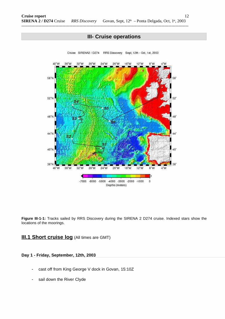
III- Cruise operations
Figure III-1-1: Tracks sailed by RRS Discovery during the SIRENA 2 D274 cruise. Indexed stars show thelocations of the moorings.
III.1 Short cruise log (All times are GMT)
Day 1 - Friday, September, 12th, 2003
- cast off from King George V dock in Govan, 15:10Z
- sail down the River Clyde

Cruise report 13SIRENA 2 / D274 Cruise RRS Discovery Govan, Sept, 12th – Ponta Delgada, Oct, 1st, 2003 ----------------------------------------------------------------------------------------------------------------------
- enter the Firth of Clyde at nightfall

Cruise report 14SIRENA 2 / D274 Cruise RRS Discovery Govan, Sept, 12th – Ponta Delgada, Oct, 1st, 2003 ----------------------------------------------------------------------------------------------------------------------Day 2 - Saturday, September, 13th, 2003
- transit southwards in the Irish Sea. Wind S 5/6. Moderate sea. Some pitch.
- Off Tuskar Rocks by 16:00
Day 3 - Sunday, September, 14th, 2003
- transit towards S6. Wind calms down in the morning. Fair sea, long atlantic swell. Spotteda few dolphins.
- 13:30. Start deployment of PS fish over the port side and towed magnetometer.
Day 4 - Monday, September, 15th, 2003
- continue transit to site S6. Light to moderate S/SE wind. Reduce speed during the night toreach S6 at daybreak.
Day 5 – Tuesday, September, 16th, 2003
- approach S6 shortly after 06:00. Magnetometer sensor on the deck.
- from 06:25 to 13:56. Recovery of S6 (see details on the recovery sheet).
Sad news: S6 recorded only 11 data files on the first hard disk and failed to jump to eitheranother partition or another disk. Reason for this is unknown. Only 6 days of data wererecorded.
- Start steaming to S5 through waypoints W65-1 and W65-2 at 14:05. Start recordingmagnetics at 14:10.
Day 6 – Wednesday, September, 17th, 2003
- reach S5 at 11:53. Immediately succeed in enabling acoustic release.
- From 11:54 to 15:50 Recovery of S5 (see details on the recovery sheet).
Good news: S5 has successfully recorded 976 data files (that is close to 488 days)
- start steaming to S4 at 16:15
- start DVD burning of S5 data.
Day 7 – Thursday, September, 18th, 2003
- on transit towards S4. Wind veers to NW 6 in the morning. Slight pitch.
- 8:00: cross the MAR axis at 50°14N. Spotted some dolphins at dusk time.
Day 8 – Friday, September, 19th, 2003

Cruise report 15SIRENA 2 / D274 Cruise RRS Discovery Govan, Sept, 12th – Ponta Delgada, Oct, 1st, 2003 ----------------------------------------------------------------------------------------------------------------------
- arrive on site at 06:15 Z from 06:15 to 10:21, recovery of S4 (see recovery sheet)S4 has successfully recorded 988 data files (that is close to 494 days)- 10:36 magnetometer in the water, start transit towards S3 through waypoints WP43-1 to
WP-43-3. Superb weather, bright blue sky and light SE wind. Sighted a lot of seabirds.
Day 9 – Saturday, September, 20th, 2003
- 13:45 arrive on site S3. Start trying to enable the release. No success with either of thetwo decksets and either of the two transducers. Weather still nice, very light wind.
- 19:50 : begin overnight magnetic profiles.
Day 10 – Sunday, September, 21st, 2003
- back over mooring at 07:30, sept, 20th. Enabling the release still not successful.
- spend morning rigging and afternoon using the recovery kit
- 20:15 . begin overnight magnetic profiles
Day 11 – Monday, September, 22nd, 2003
- 08:00. Continue attempts to enable the release and sail four passes over the estimatedposition of the mooring with recovery kit deployed. Wind (7) and waves (4m) pick up in themorning. Visibility is poor at times under rain.
- 1 8:00 :quit recovery after 52 hours on site and abandon S3 (see attached pages forconsiderations on the reasons of unsuccessful recovery operations).
- 20:00 : all recovery gear on board. Maggie in the water. Start steaming towards S2.
Day 12 – Tuesday, September, 23rd, 2003
- on transit towards S2. Wind ESE 3-4. Moderate sea and swell. 09:00 :a few dolphins playwith the ship’s bow wave for a short while .
Day 13 – Wednesday, September, 24th, 2003 (Matt ’s birthday)
- arrive on site S2 at 06:30. Start sending enable commands to the release at 07:00
- from 07:00 to 11:30, recovery of S4 (see recovery sheet)S2 has successfully recorded 1003 data files (that is approx. 501 days of data)
- 13:00 Steering gear failure drill.
- 13:30 On transit towards S1. Wind 2, calm sea, long swell.
Day 14 – Thursday, September 25th,, 2003

Cruise report 16SIRENA 2 / D274 Cruise RRS Discovery Govan, Sept, 12th – Ponta Delgada, Oct, 1st, 2003 ----------------------------------------------------------------------------------------------------------------------
- on transit towards S1.
Day 15 – Friday, September 26th,, 2003
- arrive on S1 at 07:00Z
- 07:25 start pinging. 07:28: release enabled!
- from 07:28 to 11:00, recovery of S1 (see recovery sheet)S1 has successfully recorded 1015 data files (approx. 507 days)
- 11:22 start towards WP-A1 along magnetic profiles
Day 16 – Saturday, September 27th, 2003
- sail E-W profiles to complete magnetic survey over chrons 6 and 13
Day 17 – Sunday, September 28th,, 2003
- on with the magnetic survey. Various problems with hydrophone data archive solved.
Day 18 – Monday, September 29th,, 2003
- Continue the magnetic survey. After having obtained clearance to enter Portuguesewaters, begin survey of the Sereta Ridge (NW of Terceira Is.) at 15:00.
Day 19 – Tuesday, September 30th,, 2003
- end survey of Sereta R. at 05:00Z. Sail clear of Terceira Is. by passing north the islandand begin survey to the E/SE of the island in the morning.
- the wind pick up from the north (perhaps due to hurricane “Kate” sitting 500 miles south ofour position).
- End operations and pull up the gear at 17:00 to sail for more sheltered waters south of theisland of Sao Miguel.
Day 20 – Wednesday, October 1st,, 2003
- dock in Ponta Delgada (Azores). Scientific party + 2 UKORS technicians disembark.

Cruise report 17SIRENA 2 / D274 Cruise RRS Discovery Govan, Sept, 12th – Ponta Delgada, Oct, 1st, 2003 ----------------------------------------------------------------------------------------------------------------------III-2 The autonomous hydrophones developed by the PMEL/NOAA
The instruments which were recovered during D274 have been developed by the PMEL/NOAA inNewport (OR).
Figure III-2-1: Schematics of the hydrophone moorings deployed during the SIRENA experiment
III-3 Recovery particulars
Data logging parameters (apply to all):
Sampling speed - 250HzData size - 2 byte (12-bit resolution)Number of hard disks - 3 (8GB each - 24GB total)Gain - switch setting of "0"Anti-aliasing filter - 110 HzProgram name - noaalogger2 version 1.5 (6/29/2002)
All hydrophone's hardware were checked normal with nominal power consumptions beforedeployment.
1 0 M E T E R P O L Y O L IF IN L IN E S P L IC E D IN T O L O O P
4 0 M E T E R S 3 / 4 " N Y L O N
H A R U P H O N E
5 / 8 " S A S W / T H IM B L E B U S H I N G 1 / 2 " S A S
1 , 0 0 0 M E T E R S 1 / 4 " J A C K E T E D V E C T R A N
37 I N C H S Y N T A T IC F O A M F L O A T
5 / 8 " S A S .5 m e t e rs c h a in 5 / 8 " S A S W / T H IM B L E B U S H I N G
1 / 2 " S A S
1 / 2 " S A S 5 / 8 " S L 1 / 2 " S A S
EG & G R ELEA S E
2 M E T E R 1 / 2 " C H A I N
5 / 8 " S A S
1 M E T E R C H A IN
5 / 8 " S A S
5 / 8 " S A S
1 0 M E T E R S 3 / 4 " N Y L O N M IN IM U M , A D D T O M A T C H B O T T O M D E P T H
5 / 8 " S A S W I T H B U S H I N G
5 / 8 " S A S W I T H B U S H I N G
1 / 2 " S A S
8 0 0 L b . A N C H O R C H A IN
P O L Y E S T E R L I N E , L E N G T H D E P E N D E N T O N D E P T H .
M U L T I P L E P IE C E S O F 5 / 1 6 "
1 . 5 T O N S W IV E L
7 6 0 0 S a n d p o i n t W a y N ES e a tt le , W a . 9 8 1 1 5(2 0 6 ) 5 2 6 -6 1 7 5
D R A W N B Y :
A P P R O V E D B Y :
D A T E :
D A T E :
M O O R IN G :
L O C A T I O N :
N O A A - P M E L - V E N T S
A T L A N T I C H A R U P H O N E 2 0 0 2
R I C K M I L L E R 1 7 M A R C H 2 0 0 2
A T L A N T I C , A Z O R E S
1 / 2 " S A S
1 / 2 " S A S
1 / 2 " S A S
Cruise report 18SIRENA 2 / D274 Cruise RRS Discovery Govan, Sept, 12th – Ponta Delgada, Oct, 1st, 2003 ----------------------------------------------------------------------------------------------------------------------Below are six forms summarizing the recovery operations. The moorings were recovered inreciprocal order with respect to their deployment, that is going anti-clockwise over the network, fromS6 to S1.

Cruise report 19SIRENA 2 / D274 Cruise RRS Discovery Govan, Sept, 12th – Ponta Delgada, Oct, 1st, 2003 ----------------------------------------------------------------------------------------------------------------------
Site S6 (46°59.9195N; 22°09.7787W)
Hydrophone name - H30Acoustic release - Benthos 1023
Mooring
Date - May, 31st, 2002 13:01:45 GMTAnchor drop position - 47°00.020N, 22°10.040WCable length - 3300m(1000 m Vectran, 1000 m VLS,1000 m VLS, 100 m
VLS,100mVLS,100 m VLS)Bottom depth - 4294m
Recovery
Date - Sept., 17, 2003 11 :44 GMT (released)Anchor position - 46°59.9195N; 22°09.7787WBottom depth - 4274m (3-D solution with 6 ranging stations)Weather : - S/SW 4, thick fog, poor visibility
- Arrive on site on 06 :25Z, started to enable the release- release enabled at 06 :50- start ranging at 06 :53. Ranging successful after 3 stations- try to release around 09 :00, after having done 3 more ranging stations while waiting for the fog
to clear up- slant ranges diminish (in fact due to the drift of the ship towards the instrument), but instrument
not sighted on surface. Horizontal ranges provide a hint that instrument might still be moored.- ship back over the instrument. 11 :44 successful release, after halving the signal repetition rate- hydrophone surfaces at 11:54, close to the port bow- 12:11 grapple the buoy tether alongside the starboard side- 12:30 hydrophone on deck, start to wind up mooring line- 01:56 release on the deck, start steaming to S5 through waypoints WP65 -1 and WP65- 2

Cruise report 20SIRENA 2 / D274 Cruise RRS Discovery Govan, Sept, 12th – Ponta Delgada, Oct, 1st, 2003 ----------------------------------------------------------------------------------------------------------------------
Cruise report 21SIRENA 2 / D274 Cruise RRS Discovery Govan, Sept, 12th – Ponta Delgada, Oct, 1st, 2003 ----------------------------------------------------------------------------------------------------------------------
Site S5 (49°51.3255 N; 24°34. 3195 W)
Hydrophone name - HS5Acoustic release - Benthos 1050
Mooring
Date - May, 29th, 2002 09:22 GMTAnchor drop position - 49o51.2524’N, 24o34.4461’W Cable length - 3400 m (1000m Vectron, 2000m VLS,
200mVLS, 200mVLS)Bottom depth - 4200m
Recovery
Date - sept., 17, 2003 14:15 GMT (released)Anchor position - 46°59.9195N; 22°09.7787WBottom depth - 4200 m (3-D solution with 6 ranging stations)Weather : - SW veering W 4, good visibility
- arrive on site at 11:50 Z- release enabled at 11:53- start ranging at 12:00. Ranging successful (6 stations)- try to release around 13 :00.- released at 13:27- hydrophone surfaces at 13:37, 300 m off the starboard bow- 14:08 buoy on fantail- 14:15 hydrophone on deck, start to wind up mooring line- 15:50 release on the deck, start steaming to S4
Hydrophone S5 recorded 976 data files (including the shut-down file)
Cruise report 22SIRENA 2 / D274 Cruise RRS Discovery Govan, Sept, 12th – Ponta Delgada, Oct, 1st, 2003 ----------------------------------------------------------------------------------------------------------------------
Site S4 (50°34.5458’ N; 34°29.8332 W)
Hydrophone name - HS8Acoustic release - Benthos 1048
Mooring
Date - May, 26th, 2002 10:21 GMTAnchor drop position - 50°34.531’N, 34°29.993W Cable length - 3500 m (1000m Vectran, 2000m VLS, 500mVLS)Bottom depth - 4200mShip’s course - 209°
Recovery
Date - Sept., 19, 2003 08:11 GMT (released)Anchor position - 50°34.5458’ N; 34°29.8332 WBottom depth - 4200 m (3-D solution with 5 ranging stations)Weather : - W backing SE 4, good visibility
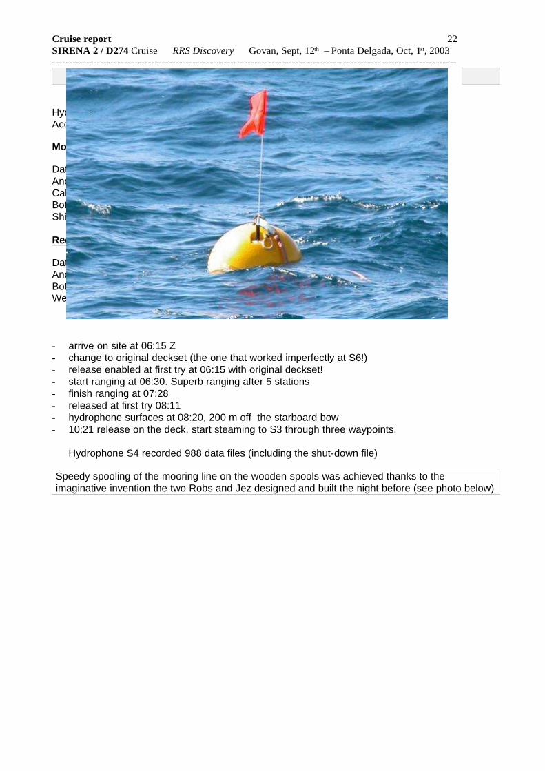
- arrive on site at 06:15 Z- change to original deckset (the one that worked imperfectly at S6!)- release enabled at first try at 06:15 with original deckset!- start ranging at 06:30. Superb ranging after 5 stations- finish ranging at 07:28- released at first try 08:11- hydrophone surfaces at 08:20, 200 m off the starboard bow- 10:21 release on the deck, start steaming to S3 through three waypoints.
Hydrophone S4 recorded 988 data files (including the shut-down file)
Speedy spooling of the mooring line on the wooden spools was achieved thanks to theimaginative invention the two Robs and Jez designed and built the night before (see photo below)

Cruise report 23SIRENA 2 / D274 Cruise RRS Discovery Govan, Sept, 12th – Ponta Delgada, Oct, 1st, 2003 ----------------------------------------------------------------------------------------------------------------------
Site S3 (estimated 47°35’39 ’ ’ N; 32°27’00 ’ ’ W)
Hydrophone name - H19Acoustic release - Benthos 1046
Mooring
Date - May, 24th, 2002 15:00 GMTAnchor drop position - 47o35.596’N, 32o27.258’WShip course - 254 degreesCable length - 3400 m (1000m Vectron, 2000m VLS, 200m VLS, 200m
VLS)Bottom depth - 4165 m
Recovery . Hydrophone not recovered
Bottom depth - unable to enable release. No ranging. Weather : - W backing SE 4 to 7, visibility good becoming poor at
time in showers
- arrive on site at 13:55 Z on sept, 20th
- try for 6 hours to communicate with release using both decksets and both transducers. Wind and sea pick up in the evening- 19:50 : begin overnight magnetic profiles.- back over mooring at 07:30, sept, 21st. Enabling the release still not successfull.- 11:30; recovery gear in the water, start trawling at 12:30.- 18:30: recovery gear on deck. Pinger lost because unsecured ring on line catcher
simply unscrewed!- 20:15 . begin overnight magnetic profiles- back over mooring at 07:30 on sept, 22nd . 08:00 > 10:00 : try to image the float with
the PDR- 10:30 : try to communicate with release using both decksets and both transducers.
No success. Wind (7) and waves (4m) pick up.- 12:00 > 18:00. Four passes over the estimated position of mooring. No success, because of
the impossibility to operate the poorly-designed recovery gear in real sea conditions.Impossible to put a weight on the bootom because of the presence of a submarinetelephone cable very near the mooring site.
- 18:50 recovery gear on board- 20:00 start steaming towards site S2.
Hydrophone S3 was not recovered.
Failure of the recovery of S3 was plagued by many problems, initially caused by the failure of theacoustic release which we were not able to overcome by dragging the mooring, this being due tothe poor design of the recovery kit.
Cruise report 24SIRENA 2 / D274 Cruise RRS Discovery Govan, Sept, 12th – Ponta Delgada, Oct, 1st, 2003 ----------------------------------------------------------------------------------------------------------------------
Site S2 (42°43.1321’ N; 34°43.3594 W)
Hydrophone name - HS6Acoustic release - Benthos 1051
Mooring
Date - May, 22nd, 2002 18:27 GMTAnchor drop position - 42°43.022’N, 34°43.336’ W Ship course - 235 degreesCable length - 3000 m (1000m Vectran, 2000m VLS)Bottom depth - 3976 mShip’s course - 209°
Recovery
Date - Sept., 24, 2003 10:43 GMT (released)Anchor position - 42°43.1321’ N; 34°43.3594’ W Bottom depth - 3956 m (3-D solution with 4 ranging stations)Weather : - light wind, very good visibility
- arrive on site at 06:30 Z- start sending the enable command at 07:00- release enabled after 1.5 hr of heartbreaking suspense (keeping in mind the failure of S3….)- ranging completed at 10:30. Anchor appears to have moved 200 m to the N from its drop
position (as would be consistent with a noticeable surface current observed on the float when itsurfaced). Start sending release commands.
- released at 10:43- hydrophone pops up on surface less than 7mn later, 100 m off the starboard bow- 11:30 release on the deck, end of S2 recovery operations..
Hydrophone S2 recorded 1003 data files (including the shut-down file)
Cruise report 25SIRENA 2 / D274 Cruise RRS Discovery Govan, Sept, 12th – Ponta Delgada, Oct, 1st, 2003 ----------------------------------------------------------------------------------------------------------------------
Site S1 ( 40°20.1955’ N; 25°02.1024 W )
Hydrophone name - H26Acoustic release - Benthos 1045
Mooring
Date - May, 19th, 2002 18:05 GMTAnchor drop position - 40°20.218’ N, 25°02.230’ W Ship course - 235 degreesCable length - 2300 m (1000m Vectran, 1000m VLS, 200m VLS,
100m VLS)Bottom depth - 3375 mShip’s course - 252°
Recovery
Date - Sept., 26, 2003 09:57 GMT (released)Anchor position - 40°20.1955’ N; 25°02.1024 W Bottom depth - 3335 m (3-D solution with 5 ranging stations)Weather : - fair & sunny weather, very light wind, very good visibility
- arrive on site at 07:00Z- start sending the enable command at 07:28. Release enabled at first try!- ranging completed at 08:35. Anchor appears to have moved 80 m to the S of the anchor drop
position.- start sending release commands at 08:57. Released at first try.- 09:08 : hydrophone pops up on surface less than 100 m off the bow.- 11:00 release on the deck, end of S2 recovery operations..
Hydrophone S1 recorded 1015 data files (including the shut-down file)
Cruise report 26SIRENA 2 / D274 Cruise RRS Discovery Govan, Sept, 12th – Ponta Delgada, Oct, 1st, 2003 ----------------------------------------------------------------------------------------------------------------------
IV –Along-track data
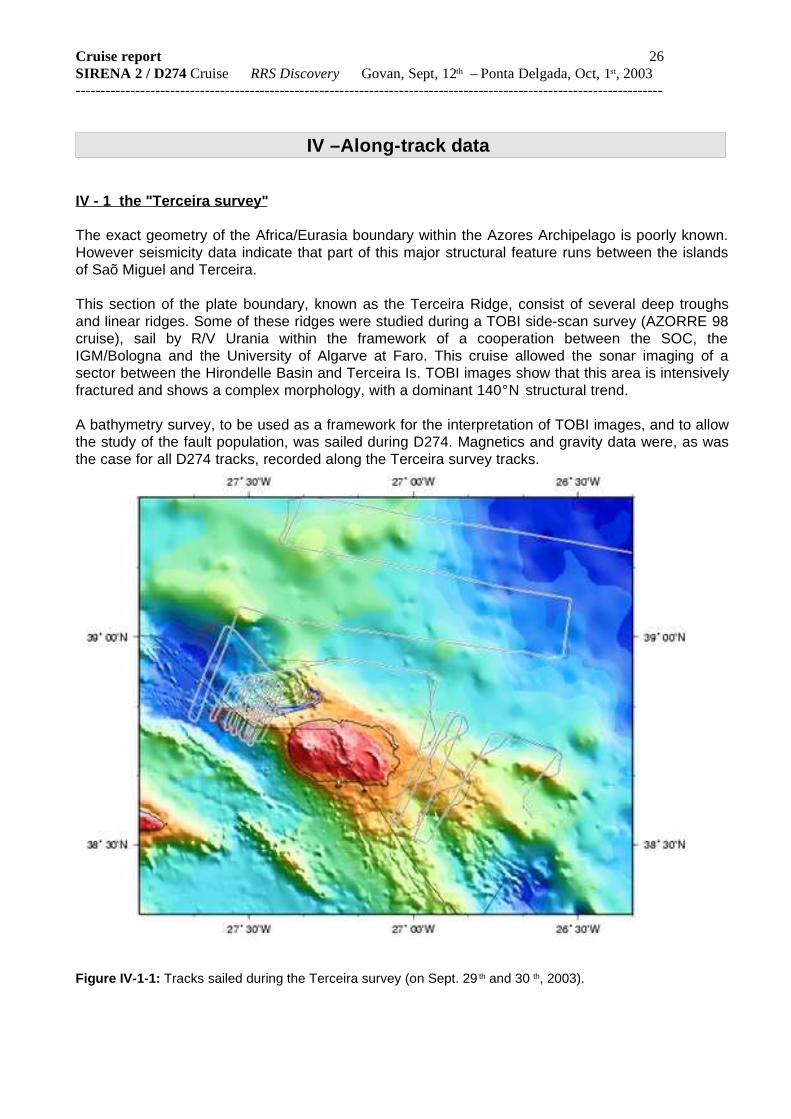
IV - 1 the "Terceira survey"
The exact geometry of the Africa/Eurasia boundary within the Azores Archipelago is poorly known.However seismicity data indicate that part of this major structural feature runs between the islandsof Saõ Miguel and Terceira.
This section of the plate boundary, known as the Terceira Ridge, consist of several deep troughsand linear ridges. Some of these ridges were studied during a TOBI side-scan survey (AZORRE 98cruise), sail by R/V Urania within the framework of a cooperation between the SOC, theIGM/Bologna and the University of Algarve at Faro. This cruise allowed the sonar imaging of asector between the Hirondelle Basin and Terceira Is. TOBI images show that this area is intensivelyfractured and shows a complex morphology, with a dominant 140°N structural trend.
A bathymetry survey, to be used as a framework for the interpretation of TOBI images, and to allowthe study of the fault population, was sailed during D274. Magnetics and gravity data were, as wasthe case for all D274 tracks, recorded along the Terceira survey tracks.
Figure IV-1-1: Tracks sailed during the Terceira survey (on Sept. 29 th and 30 th, 2003).
Cruise report 27SIRENA 2 / D274 Cruise RRS Discovery Govan, Sept, 12th – Ponta Delgada, Oct, 1st, 2003 ----------------------------------------------------------------------------------------------------------------------
Luis, J. F., J. M. Miranda, A. Galdeano, P. Patriat , Constraints on The Structure of the Azores Spreading Center fromGravity Data. Marine Geophysical Research, 20, 157-170, 1998.
Lourenço, N, J. M. Miranda, J. F. Luis, A. Ribeiro, L.A. Mendes Victor, Madeira, J & H. D. Needham, Morpho-tectonicanalysis of the Azores Volcanic Plateau from a new bathymetric compilation of the area. Marine GeophysicalResearch, 20, 141-156, 1998.
Miranda, J. M., L. A. Mendes Victor, J. Z. Simões, J. F. Luis, L. Matias, H. Shimamura, H. Shiobara, H Nemoto, H.Mochizuki, A. Hirn, J. C. Lépine, Tectonic setting of the Azores Plateau deduced from a OBS survey. Mar GeophysRes, 20, 171-182, 1998.
J. Freire Luis, J.M. Miranda, A. Galdeano, P. Patriat, J.C. Rossignol and L.A. Mendes Victor. Azores Triple Junctionevolution since 10 Ma from an Aeromagnetic survey of the Mid-Atlantic Ridge. Earth and Planetary Science Letters125, 439-459, 1994.
Luis J. F., N. Lourenço, J. M. Miranda, J. L.Gaspar and G. Queiroz. A Submarine Eruption west of Terceira Island(Azores Archipelago). Interridge News. Vol 8: Nº1: 13-14, 1999.
Ligi M., N. C. Mitchell, M. Marani, F. Gamberi, D. Penitenti, G. Carrara, M. Rovere, R. Portaro, G. Centorami, G.Bortoluzzi, C. Jacobs, I. Rouse, C. Flewellen, S. Whittle, P. Terrinha, J. Freire Luis and N. Lourenço. GiantVolcanic Ridges Amongst the Azores islands. Fall Meeting of the American Geophysical Union, 1999.
Ligi M., N. C. Mitchell, M. Marani, G. Carrara, F. Jacobs, N. Lourenço, J. F. Luis, D. Penitenti, R. Poraro, M. Rovere, P.Terrinha. Tectonic control on the growth of giant Volcanic Ridges in the Azores. XXV EGS, Nice, 2000.
Lourenço N., J. Luis, M. Miranda, M. Ligi, and the AZORRE 99 Team. Linear Volcanic Ridges in the Azores: preliminarycharacterization from TOBI data. 3º Simpósio da Margem Ibérica Atlântica, Faro, p 197, 2000.
IV - 2 other along-track data
Single beam PDR, towed proton magnetometer and shipboard gravity data were continuouslyrecorded along the ship’s tracks during D274.
These tracks were planed in three different contexts:
- first, we endeavored to avoid night-time mooring operations by sailing short-duration magneticprofiles in the vicinity of the mooring sites, if we were to be arriving on site after night fall.Similarly, we adapted the transit time between sites so as to reach the next site not sooner thandaybreak, whenever possible, by bridging gaps in magnetic anomaly contour picks.
- Second, we spent two nights sailing magnetic lines in the vicinity of site S3, in between theattempts to recover the instrument.
- Third, we devoted two days to the sailing of a magnetic survey of the eastern flank of the Mid-Atlantic Ridge, north and south of site S1, after the recovery of hydrophone S1 was completedand before beginning the Terceira Survey.
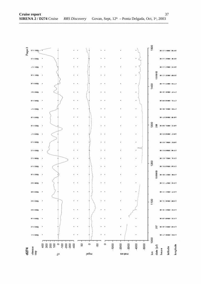
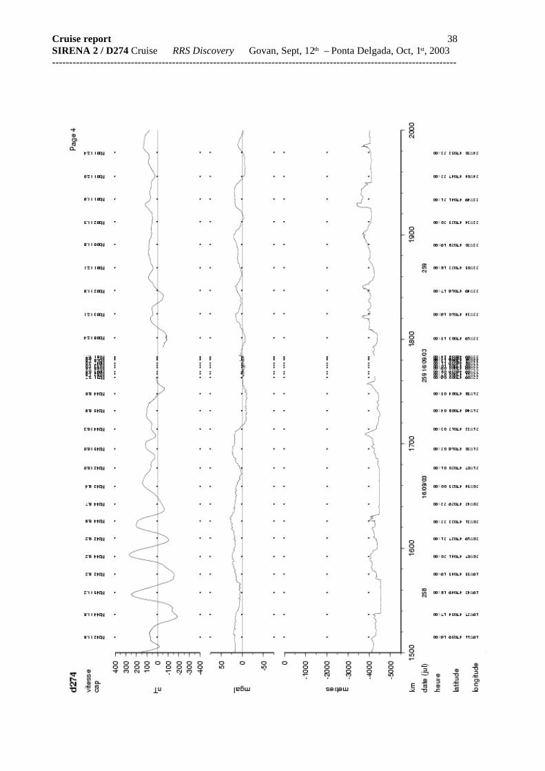
Details on how the along-track data were recorded and processed on board (essentially to edit thespurious magnetic and gravity data) are given below, and linear plots of the along-track data can befound in the subsequent appendix..
IV – 3 Data processing
The RSS Discovery sailed close to 4400 nautical miles ( close to 8150 km) during theSirena2/D274 cruise. Single-beam bathymetry was recorded along ////// miles, magnetics along /////miles and gravity along //// miles. RSS Discovery sailed from Govan on Sept., 12th (day 255) at

Cruise report 28SIRENA 2 / D274 Cruise RRS Discovery Govan, Sept, 12th – Ponta Delgada, Oct, 1st, 2003 ----------------------------------------------------------------------------------------------------------------------16:00 local time (GMT+1). The recording of along-track data did not start before Sept., 14th around15:00, after the continental slope was encountered in Goban Bight, southwest of Ireland.
Very few gaps disrupt the recording of along-track data. The towed magnetometer fish waspulled onboard when approaching the mooring sites and the echo-sounder was generally stoppedduring recovery operations, not to interfere with the ranging and release signals sent to the acousticrelease.
Data were acquired in quasi-real time and stored in 24h-files (named d274_jjj.suf where jjj=julianday and .suf= suffix .bat, .mag and .gra). The “listit” tool allowed to extract the different data setsfrom the data strings in quasi-real time.
Data were processed on a daily basis and archived in the binary rbgm format (EOPGSStrasbourg), from which several variables can be easily extracted: time (in various formats), depth,gravity (free-air anomaly), magnetics (total field and anomaly), cumulate distance (km, miles),ship’s speed (knots, m/s) and ship’s course. Conversions from the rbgm to GMT and MGD77formats is also possible.
Navigation
The ship’s raw navigation is estimated from two GPS receivers GPS (Trimble 4000DL andAshtech GG85), an electromagnetic log and a gyrocompass. Data from these various instrumentsare archived in separate files (named gps_4000, gps_glos, log_chf, gyronmea, resp.). They arethen merged and stored in two files which contain the processed navigation and drift data (named“bestnav” and “bestdrift”). The consistency of these two files is checked every day by theoperator. If spurious are found, they are edited and the program which produces bestnav andbestdrift is run again. The log sensor proved to be very imprecise (speed of 2 knots over the GPSspeed) and requires a calibration.
We based our navigation on the “bestnav” and “bestdrift” files, whose detailed format is givenbelow. Navigation gaps are shorter than 1 to 2 minutes. The longer gap was due to a gyrocompassfailure (9/23/2003 from 12:15 to 13:04). In the absence of any gyro signal, it was impossible toproduce a corrected navigation during this gap and we chose to supplement the missing points bythe raw GPS points from the gps_4000 file.
The final navigation is archived every 10 seconds. Instantaneous speed and course include a0.3-knot and 3° average noise. We finally decimated 2 out of 3 points to produce a one-minute file.
Processing steps
1. Simple décimation of the smoothed navigation (bestnav) every 30 s or 1 mn.
Bestnav data format
Time lat lon long_velocity lat_velocity course_made_good speed_made_good dist_run heading 03 262 20:54:40 4.950796e+01 50 -3.234582e+01 50 -4.059884e+00 50 1.100077e+0150 1.102568e+02 50 1.172602e+01 50 3.283313e+03 50 1.099397e+02 40 03 262 20:54:50 4.950777e+01 50 -3.234505e+01 50 -3.948155e+00 50 1.091250e+0150 1.098902e+02 50 1.160476e+01 50 3.283372e+03 50 1.098504e+02 40 03 262 20:55:00 4.950758e+01 50 -3.234428e+01 50 -4.243292e+00 50 1.088187e+0150 1.113029e+02 50 1.167993e+01 50 3.283432e+03 50 1.096697e+02 40
03 262 20:55:10 4.950739e+01 50 -3.234350e+01 50 -4.113745e+00 50 1.096821e+0150 1.105591e+02 50 1.171428e+01 50 3.283493e+03 50 1.092896e+02 40

Cruise report 29SIRENA 2 / D274 Cruise RRS Discovery Govan, Sept, 12th – Ponta Delgada, Oct, 1st, 2003 ----------------------------------------------------------------------------------------------------------------------03 262 20:55:20 4.950721e+01 50 -3.234271e+01 50 -3.773176e+00 50 1.107205e+0150 1.088183e+02 50 1.169732e+01 50 3.283553e+03 50 1.092216e+02 40
03 262 20:55:30 4.950704e+01 50 -3.234192e+01 50 -3.727754e+00 50 1.112884e+0150 1.085190e+02 50 1.173658e+01 50 3.283613e+03 50 1.095888e+02 40
03 262 20:55:40 4.950686e+01 50 -3.234114e+01 50 -3.839809e+00 50 1.099764e+0150 1.092466e+02 50 1.164870e+01 50 3.283673e+03 50 1.092301e+02 40
03 262 20:55:50 4.950668e+01 50 -3.234035e+01 50 -3.996856e+00 50 1.112402e+0150 1.097633e+02 50 1.182027e+01 50 3.283734e+03 50 1.084078e+02 40
yy*jjj*hh:mm:ss*** lat *qq* lon *qq* vn *qq* ve *qq* cmg *qq* smg *qq* dist *qq* cap*qq*
Each files contains a 2-line header (includes one blank line, 155-characters total, including 2carriage return characters)
154-character frame(including one carriage return char.)
yy yaerjjj julian dayhh:mm:ss GMT timelat latitudelon longitudevn longitudinal speed(+ towards the North) [knots]ve latitudinal speed (+ towards the East) [knots]cmg true course (course-made-good)vmg true speed (speed-made-good) [knots]dist_run total distance sailed [km]heading gyrocompass headingqq quality flag (valid data qq=50)
Other files contain the following information:
gyronmea time, course (hdg)log_chf time, speedfa (fore/aft), speedps (port/starboard)relmov time, vn (vit. Nord), ve (vit. Est), pfa (fore/aft drift), pps
(port/starboard drift), pgyro (mean gyro heading)[dead reckoning file computed from gyronmea and log_chf]
bestdrf time, vn, ve (computed vn and ve), kvn, kve (observed vn and vek=known)[second file produced simultaneously with bestnav]
Magnetics
Magnetic data were obtained by a towed Varian V-75 proton magnetometer. The fish was towed150 m behind the ship’s stern. The distance between the GPS antenna, rigged on the main mastand the ship’s stern was 50 m. An offset correction of 200 metres was therefore applied to allmeasurements. Even if recorded every 6 seconds, the magnetic data were stored every second(the same value being repeated 6 times). Data were then reduced to one-minute points, after amedian filter, centerd on each minute point, was applied to the raw data (10 data points are takeninto account to compute each one-minute point). The magnetic anomaly is computed from theIGRF4505 model, i.e. from DGRF from 1945 to 1995, IGRF 2000 and extrapolation of the secularvariation over the period 2000-2005. This model does not fully corrects for regional field variations

Cruise report 30SIRENA 2 / D274 Cruise RRS Discovery Govan, Sept, 12th – Ponta Delgada, Oct, 1st, 2003 ----------------------------------------------------------------------------------------------------------------------and a long-wavelength correction of 100 to 200 nT appears to be needed. The magnetometerproved very noisy (20-30 nT) during some periods. The mean noise level is around 5 to 10 nT.
Processing steps
1. reading the files lecture from the data acquisition server (time, total field) and decimation to restore theinitial sampling rate (6s)
2. time correction to account for the offset between the GPS antenna and the magnetometer fish.3. computation of one-minute values with a median filter4. merging with the navigation data5. magnetic anomaly reduction from IGRF4505 ; storage of the total field and anomaly data rounded to the
next integer (nT).
Data format
Time magfld 03 257 21:08:59 4.781500e+04 50 03 257 21:09:00 4.781500e+04 50 03 257 21:09:01 4.781510e+04 50 03 257 21:09:02 4.781510e+04 50 03 257 21:09:03 4.781510e+04 50 aa*jjj*hh:mm:ss***ffffffffffff qq*
2-line header (36-characters total including 2 carriage return char.)frame length: 35 characters (includes one carriage return char.)
aa yearjjj julian dayhh:mm:ss GMT timeffffff total field intensity [0.1 nT]qq quality flag (valid data qq=50)
qq=40 for edited data
Gravity
A Lacoste and Romberg model S gravity meter is installed on board RSS Discovery. Thisinstrument is fitted with an “AirSea 3.0” digital data acquisition system. Gravity data are outputfrom the gravity meter with a 5-minute delay with respect to the other data sets. This delaycorresponds to the “famous” 5-minute filter which is built in the gravity meter data acquisitionsystem (see the Lacoste & Romberg documentation sheets). This filter smoothes out thecontribution of the ship’s movements to the gravity signal. Data are sampled every 10 seconds andarchived every second (the same value is repeated 10 times).
The time stamp attached to each gravity value corresponds to the time at which themeasurement is effectively taken and NOT (as is frequently the case) to the time when themeasurement is output from the system (5 mn later). This was checked by observing the gravitymeter response to rapid changes in the ship’s speed or course. No offset was observed, exceptthat the clock of the acquisition PC was consistently 85 seconds late; this was corrected on Sept,16th, 2003 at 10:56:33.
As was done for the magnetic anomaly, a median value over a one-minute moving window(±30s) was computed for the free-air gravity anomaly. To lessen the noise introduced by the Eötvosand latitude corrections, instantaneous course, speed and latitude were averaged over a 5-mnwindow, centred on each data point.
Cruise report 31SIRENA 2 / D274 Cruise RRS Discovery Govan, Sept, 12th – Ponta Delgada, Oct, 1st, 2003 ----------------------------------------------------------------------------------------------------------------------Computation of the free-air anomaly
The free-air anomaly was computed by using the Govan (King George V Dock) gravity tie andsupposing no gravity meter sensor drift. After this tie was performed and three days before the shipsailed, the gravity meter was shut down several times on Sept, 8th, 2003, after the ship underwenttotal electric power failures. Twenty four hours after the gravity meter was back on again (Sept, 11th,2003), the spring tension and gravity values started to converge again. The ship’s draught andwater heights were then re-measured to check that the value which was then read corresponded tothe value recorded during the gravity tie (this point is still under investigation). Definitive data will berecomputed when the results from the tie in Lisbon are known.
Cruise report 32SIRENA 2 / D274 Cruise RRS Discovery Govan, Sept, 12th – Ponta Delgada, Oct, 1st, 2003 ----------------------------------------------------------------------------------------------------------------------
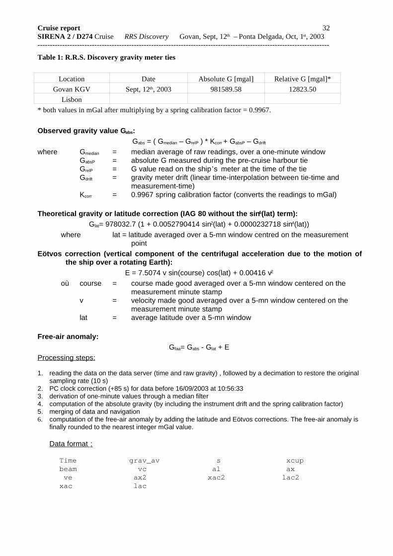
Table 1: R.R.S. Discovery gravity meter ties
Location Date Absolute G [mgal] Relative G [mgal]*
Govan KGV Sept, 12th, 2003 981589.58 12823.50
Lisbon
* both values in mGal after multiplying by a spring calibration factor = 0.9967.
Observed gravity value Gabs:Gabs = ( Gmedian – GrelP ) * Kcorr + GabsP – Gdrift
where Gmedian = median average of raw readings, over a one-minute windowGabsP = absolute G measured during the pre-cruise harbour tieGrelP = G value read on the ship’s meter at the time of the tieGdrift = gravity meter drift (linear time-interpolation between tie-time and
measurement-time) Kcorr = 0.9967 spring calibration factor (converts the readings to mGal)
Theoretical gravity or latitude correction (IAG 80 without the sin6(lat) term):Glat= 978032.7 (1 + 0.0052790414 sin2(lat) + 0.0000232718 sin4(lat))
where lat = latitude averaged over a 5-mn window centred on the measurementpoint
Eötvos correction (vertical component of the centrifugal acceleration due to the motion ofthe ship over a rotating Earth):
E = 7.5074 v sin(course) cos(lat) + 0.00416 v2
où course = course made good averaged over a 5-mn window centered on themeasurement minute stamp
v = velocity made good averaged over a 5-mn window centered on themeasurement minute stamp
lat = average latitude over a 5-mn window
Free-air anomaly:Gfaa= Gabs - Glat + E
Processing steps:
1. reading the data on the data server (time and raw gravity) , followed by a decimation to restore the originalsampling rate (10 s)
2. PC clock correction (+85 s) for data before 16/09/2003 at 10:56:333. derivation of one-minute values through a median filter4. computation of the absolute gravity (by including the instrument drift and the spring calibration factor) 5. merging of data and navigation6. computation of the free-air anomaly by adding the latitude and Eötvos corrections. The free-air anomaly is
finally rounded to the nearest integer mGal value.
Data format :
Time grav_av s xcup beam vc al ax ve ax2 xac2 lac2 xac lac

Cruise report 33SIRENA 2 / D274 Cruise RRS Discovery Govan, Sept, 12th – Ponta Delgada, Oct, 1st, 2003 ----------------------------------------------------------------------------------------------------------------------03 262 23:20:00 1.219530e+04 50 1.219740e+04 50 1.900000e+00 508.700000e+01 50 4.000000e+00 50 -8.000000e+00 50 3.900000e+01 509.000000e+00 50 -3.000000e+00 50 6.500000e+01 50 3.000000e+00 50-3.060000e+02 50 5.400000e+01 50 03 262 23:20:01 1.219530e+04 50 1.219740e+04 50 -1.000000e-01 50-7.500000e+01 50 5.000000e+00 50 1.700000e+01 50 4.000000e+00 501.800000e+01 50 0.000000e+00 50 9.000000e+00 50 8.000000e+00 50-1.400000e+01 50 -9.700000e+01 50 03 262 23:20:02 1.219530e+04 50 1.219740e+04 50 -2.500000e+00 50-3.360000e+02 50 3.400000e+01 50 4.200000e+01 50 -7.100000e+01 502.800000e+01 50 -5.000000e+00 50 9.800000e+01 50 2.600000e+01 503.720000e+02 50 -1.970000e+02 50
2-lines header (total of 1+239 characters including 2 carriage returnchar.)
frame length 239 characters (including one carriage return char.)
aa yearjjj julian dayhh:mm:ss GMT time of the measurement grav_av average gravity value (spring factor not included)s raw spring tension factorxcup total correctionbeam beam position (1-s average) [mV]vc+ve+al+ax+ax2+xac+xac2+lac+lac2 = cc cross-coupling correction (1-s
average) [mV]qq quality flag (valid data qq=50)
g = s + xcup + cc
Bathymetry
Soundings are recorded with the help of a narrow-beam single-beam Simrad EA500 echo-sounder. The fish sensor was lowered from a boom on the port side of the ship. The sea-bottomdetection algorithm has a sample rate of 6 to 7seconds. Depth values are output by the data archiveserver, after they have received a correction derived from Matthew’s celerity tables.
For each position (every 30 s or 1 mn) a depth value was computed as the median average overa ±30-s window centred on each navigation point (that is over 8 to 10 soundings). Such anaveraging allows to edit isolated spurious soundings, but fails to operate when the echo-sounderfails to detect the bottom during several samples in a row and outputs a sequence of non-coherentvalues. A manual editing of the depth data files proved necessary after slopes above 25% wereautomatically searched for along the profiles. After such an edition, the noise level on a flat bottomis in the order of one meter..
Processing steps
1. reading the raw data files from the data archive server (time, depth) 2. manual editing (defective points are given a quality flag qq=40)3. one-minute values from a median filter4. merging of data and navigation

Cruise report 34SIRENA 2 / D274 Cruise RRS Discovery Govan, Sept, 12th – Ponta Delgada, Oct, 1st, 2003 ----------------------------------------------------------------------------------------------------------------------
Data format
Time depth rpow angfa angps 03 262 23:20:26 3.923500e+03 50 -6.000000e+00 50 1.000000e+00 500.000000e+00 50
03 262 23:20:33 3.923000e+03 50 7.000000e+00 50 1.000000e+00 500.000000e+00 50 03 262 23:20:40 3.923000e+03 50 1.000000e+00 50 1.000000e+00 500.000000e+00 50 03 262 23:20:46 3.922500e+03 50 6.000000e+00 50 1.000000e+00 500.000000e+00 50
03 262 23:20:53 3.923000e+03 50 1.000000e+00 50 1.000000e+00 500.000000e+00 50 03 262 23:20:59 3.922500e+03 50 4.000000e+00 50 1.000000e+00 500.000000e+00 50 aa jjj hh:mm:ss depth qq rpow qq angfa qq angps qq*
2-lines header (total of 1+86 characters including 2 carriage return char.)frame lenght 86 characters (includes the carriage return character)
aa yearjjj julian dayhh:mm:ss GMT timedepth corrected depth in metresrpow reflected power [dB]angfa alongship sea-bottom slope [deg.]angps athwartship sea-bottom slope [deg.]qq quality flag (valid sounding qq=50,
qq=40 for manually edited soundings
Cruise report 35SIRENA 2 / D274 Cruise RRS Discovery Govan, Sept, 12th – Ponta Delgada, Oct, 1st, 2003 ----------------------------------------------------------------------------------------------------------------------
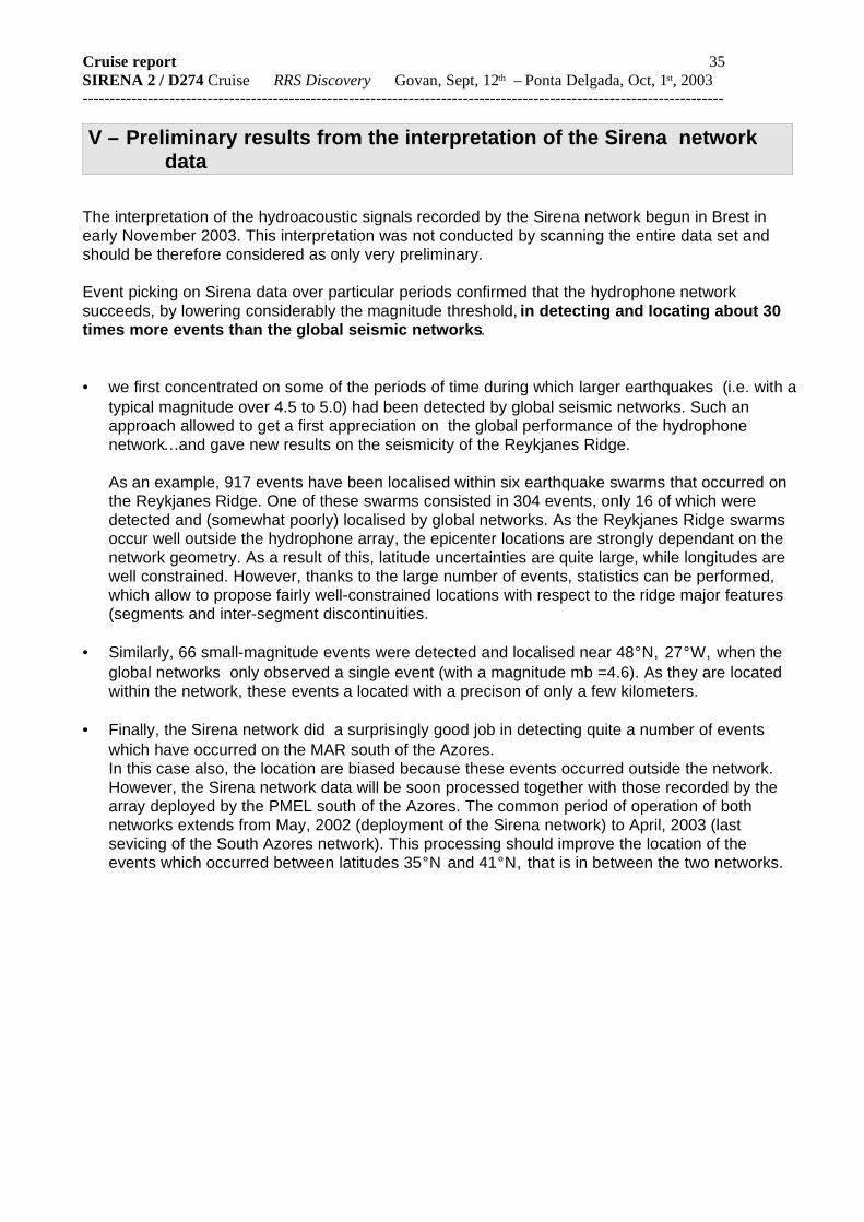
V – Preliminary results from the interpretation of the Sirena networkdata
The interpretation of the hydroacoustic signals recorded by the Sirena network begun in Brest inearly November 2003. This interpretation was not conducted by scanning the entire data set andshould be therefore considered as only very preliminary.
Event picking on Sirena data over particular periods confirmed that the hydrophone networksucceeds, by lowering considerably the magnitude threshold, in detecting and locating about 30times more events than the global seismic networks.
• we first concentrated on some of the periods of time during which larger earthquakes (i.e. with atypical magnitude over 4.5 to 5.0) had been detected by global seismic networks. Such anapproach allowed to get a first appreciation on the global performance of the hydrophonenetwork… and gave new results on the seismicity of the Reykjanes Ridge.
As an example, 917 events have been localised within six earthquake swarms that occurred onthe Reykjanes Ridge. One of these swarms consisted in 304 events, only 16 of which weredetected and (somewhat poorly) localised by global networks. As the Reykjanes Ridge swarmsoccur well outside the hydrophone array, the epicenter locations are strongly dependant on thenetwork geometry. As a result of this, latitude uncertainties are quite large, while longitudes arewell constrained. However, thanks to the large number of events, statistics can be performed,which allow to propose fairly well-constrained locations with respect to the ridge major features(segments and inter-segment discontinuities.
• Similarly, 66 small-magnitude events were detected and localised near 48°N, 27°W, when theglobal networks only observed a single event (with a magnitude mb =4.6). As they are locatedwithin the network, these events a located with a precison of only a few kilometers.
• Finally, the Sirena network did a surprisingly good job in detecting quite a number of eventswhich have occurred on the MAR south of the Azores. In this case also, the location are biased because these events occurred outside the network.However, the Sirena network data will be soon processed together with those recorded by thearray deployed by the PMEL south of the Azores. The common period of operation of bothnetworks extends from May, 2002 (deployment of the Sirena network) to April, 2003 (lastsevicing of the South Azores network). This processing should improve the location of theevents which occurred between latitudes 35°N and 41°N, that is in between the two networks.

Cruise report 36SIRENA 2 / D274 Cruise RRS Discovery Govan, Sept, 12th – Ponta Delgada, Oct, 1st, 2003 ----------------------------------------------------------------------------------------------------------------------
Cruise report 37SIRENA 2 / D274 Cruise RRS Discovery Govan, Sept, 12th – Ponta Delgada, Oct, 1st, 2003 ----------------------------------------------------------------------------------------------------------------------
Cruise report 38SIRENA 2 / D274 Cruise RRS Discovery Govan, Sept, 12th – Ponta Delgada, Oct, 1st, 2003 ----------------------------------------------------------------------------------------------------------------------
Cruise report 39SIRENA 2 / D274 Cruise RRS Discovery Govan, Sept, 12th – Ponta Delgada, Oct, 1st, 2003 ----------------------------------------------------------------------------------------------------------------------
Cruise report 40SIRENA 2 / D274 Cruise RRS Discovery Govan, Sept, 12th – Ponta Delgada, Oct, 1st, 2003 ----------------------------------------------------------------------------------------------------------------------

Cruise report 41SIRENA 2 / D274 Cruise RRS Discovery Govan, Sept, 12th – Ponta Delgada, Oct, 1st, 2003 ----------------------------------------------------------------------------------------------------------------------

Cruise report 42SIRENA 2 / D274 Cruise RRS Discovery Govan, Sept, 12th – Ponta Delgada, Oct, 1st, 2003 ----------------------------------------------------------------------------------------------------------------------

Cruise report 43SIRENA 2 / D274 Cruise RRS Discovery Govan, Sept, 12th – Ponta Delgada, Oct, 1st, 2003 ----------------------------------------------------------------------------------------------------------------------

Cruise report 44SIRENA 2 / D274 Cruise RRS Discovery Govan, Sept, 12th – Ponta Delgada, Oct, 1st, 2003 ----------------------------------------------------------------------------------------------------------------------

Cruise report 45SIRENA 2 / D274 Cruise RRS Discovery Govan, Sept, 12th – Ponta Delgada, Oct, 1st, 2003 ----------------------------------------------------------------------------------------------------------------------

Cruise report 46SIRENA 2 / D274 Cruise RRS Discovery Govan, Sept, 12th – Ponta Delgada, Oct, 1st, 2003 ----------------------------------------------------------------------------------------------------------------------

Cruise report 47SIRENA 2 / D274 Cruise RRS Discovery Govan, Sept, 12th – Ponta Delgada, Oct, 1st, 2003 ----------------------------------------------------------------------------------------------------------------------

Cruise report 48SIRENA 2 / D274 Cruise RRS Discovery Govan, Sept, 12th – Ponta Delgada, Oct, 1st, 2003 ----------------------------------------------------------------------------------------------------------------------

Cruise report 49SIRENA 2 / D274 Cruise RRS Discovery Govan, Sept, 12th – Ponta Delgada, Oct, 1st, 2003 ----------------------------------------------------------------------------------------------------------------------

Cruise report 50SIRENA 2 / D274 Cruise RRS Discovery Govan, Sept, 12th – Ponta Delgada, Oct, 1st, 2003 ----------------------------------------------------------------------------------------------------------------------

Cruise report 51SIRENA 2 / D274 Cruise RRS Discovery Govan, Sept, 12th – Ponta Delgada, Oct, 1st, 2003 ----------------------------------------------------------------------------------------------------------------------


![Sage, Angie - [Septimus Heap] 05 Sirena](https://static.fdocuments.in/doc/165x107/55cf99a0550346d0339e5a21/sage-angie-septimus-heap-05-sirena.jpg)