The SCM #003
16
The Sub-Carpathian Messenger – Number 3 (March 2009) Page 1 The Sub-Carpathian Messenger Newsletter of the Study Circle for the Postal History of the Carpatho-Ukraine Number 3 – March 2009 The earliest postmark from the Sub-Carpathian area: the negative seal of Ungvár in red
-
Upload
subcarpathian -
Category
Education
-
view
443 -
download
6
Transcript of The SCM #003
The Sub-Carpathian Messenger – Number 3 (March 2009) Page 1
The Sub-Carpathian Messenger
Newsletter of the Study Circlefor the Postal History of the Carpatho-Ukraine
Number 3 – March 2009
The earliest postmark from the Sub-Carpathian area: the negative seal of Ungvár in red
The Sub-Carpathian Messenger – Number 3 (March 2009) Page 2
The final word
on Fedor Feketa (or Fekete Ferenc, if you prefer Hungarian): The memorial plaque shownon the title page of SCM#002 says that he died in 1838. This is wrong – Peter Cybiniak andRoman Dubyniak state correctly that he died 18 March 1839 from a lung infection. We aresorry to have confused a few (very thorough) readers.
About forgeries of pre-philatelic Hungarian stamps
We are aware that a strong discussion is going on in the interested circles in Hungary andeven has lead to a major friction between the MABÉOSZ and the Philatelic Academy. We donot and will not take sides in this discussion. But we consider it to be in our own interest ifwe are wary of possible forgeries. The case shown in the Snippets section of the last„Messenger” was clear enough to warrant a decisive classification as a crude forgery. Youreditor was the one who checked – sorry if the author of this page was not clear.
About us and the Newsletter
The Study Circle is a loose group of persons who are interested in the postal (and general)history of the area known as Kárpátalja in Hungarian, as Podkarpatská Rus during the FirstCzechoslovak Republic, which had a short day of independence as Carpatho Ukraine, andlater was integrated into the Ukrainian SSR in the Soviet Union as the ‘Zakarpatskaja Ob-last’. Since 1991 it is the westernmost administrative district in the Ukraine.
The Newsletter came out of a meeting of a few collectors during the PRAHA 2008, its firstnumber appeared in November 2008. Since then it has been growing steadily. We aim toproduce between four and six numbers per year (if input allows) but do not promise regu-lar publication intervals.
At the moment our Newsletter goes to about 30 interested persons, mostly by e-mail, to afew (who have no e-mail access or have tight size limits on their input boxes) as a colourprint-out by classical mail. The Newsletter is sent as a PDF file and has between 5 and 6megabytes in transfer.
Our warm welcome to Roger ACQUISTAPACE (United States of America), Dipl.Ing. MiroslavBACHRATÝ (Slovakia) and JAKAB András (Hungary).
All articles in the Newsletter carrying the name of an author are the sole responsibility ofthis author and should not be taken to represent the common opinion of the Study Circle.Such articles are, if not marked otherwise, copyrighted by the respective author. Free usewithin the Study Circle is granted.
Participation in the Study Circle is not bound to a formal membership and does not includethe duty to pay a membership fee. There is a moral obligation to support the Newsletterfrom time to time by sending some article, some interesting piece of information, somequestion, some answer or whatever.
We will “print” everything even only loosely connected with our subject of interest so anycontribution is certainly welcome. Please send it (as a Word 2000 document, graphicalelements in JPEG, 300 dpi) to our editor’s e-mail address ([email protected]). His postal address,if you would need it, is:
Dr. Helmut Kobelbauer Untergrossau 81
A-8261 Sinabelkirchen, Austria / Europe

The Sub-Carpathian Messenger – Number 3 (March 2009) Page 3
Jan RompesThe first postmarks from UNGVAR
The post office of Ungvar opened in 1786 and started to use postmarks in 1814. In fact thefirst canceller was not a postmark but a post office seal used as postmark. It is extremelyrare and up till now only three letters have been recorded with this post office seal.
One letter in the Terfi collection, which is now in the stamp museum in Budapest and twoin private hands. A number of falsifications have been noticed meanwhile.
The first „real“ postmark of Ungvar is a straight line one introduced in 1815. Pretty earlyas most of the newly introduced postmarks in Austria-Hungary came to light in 1817, aftera new postal regulation instructed to mark the place of mailing on the letters.
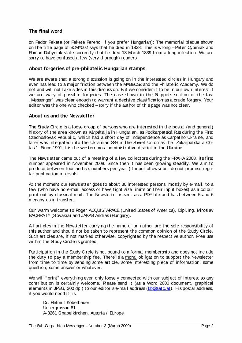
In the handbooks of Terfi, Müller and Ber/Makkai its use is recorded from 1815 till 1847. Avery long existence of the postmark indeed. In the beginning of its use the colour was redas can be seen on the following letter.
Fig. 1: Private prepaid letter, zone 7, weight ½ Loth, tax 14 kr, therefore after June 1, 1817
Later copies so far have only been seen in black.
The other day I bought a collection containing a number of these postmarks and after care-ful studying it appeared that in the years 1846 and 1847 a smaller type was used. The com-parison of the next two letters marks the difference of the 2 subtypes.
The Sub-Carpathian Messenger – Number 3 (March 2009) Page 4
Fig. 2: Private letter, from UNGHVAR to Leucsovie (Löcse/Levoca), March 16, 1842, tax 8 kr
Fig. 3: Official church letter to Eperjes, November 24, 1846
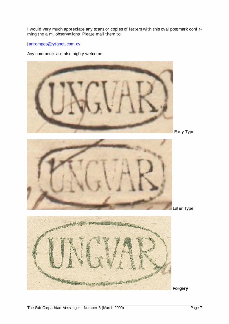
In this contribution I would like to dwell upon the second postmark of Ungvar as well. Itconcerns a dateless postmark with an oval frame in Roman type. In the existing literaturestarting with the Terfi handbook it was known to be in use from 1820-1842 in both red andgreen colours. Terfi did not know a black one!
Müller mentions the first use in 1815 in red which is remarkable as this postmark wouldhave been introduced simultaneously with the straight line postmark in that year, whichseems highly unlikely.
The Sub-Carpathian Messenger – Number 3 (March 2009) Page 5
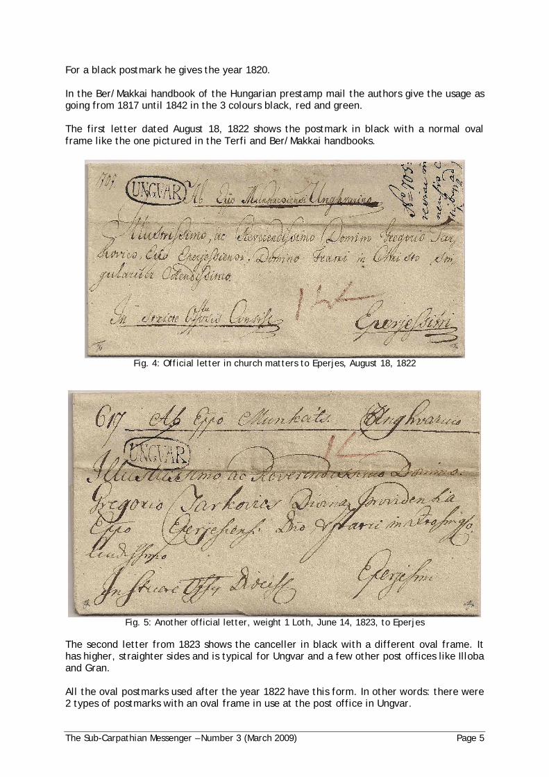
For a black postmark he gives the year 1820.
In the Ber/Makkai handbook of the Hungarian prestamp mail the authors give the usage asgoing from 1817 until 1842 in the 3 colours black, red and green.
The first letter dated August 18, 1822 shows the postmark in black with a normal ovalframe like the one pictured in the Terfi and Ber/Makkai handbooks.
Fig. 4: Official letter in church matters to Eperjes, August 18, 1822
Fig. 5: Another official letter, weight 1 Loth, June 14, 1823, to Eperjes
The second letter from 1823 shows the canceller in black with a different oval frame. Ithas higher, straighter sides and is typical for Ungvar and a few other post offices like Illobaand Gran.
All the oval postmarks used after the year 1822 have this form. In other words: there were2 types of postmarks with an oval frame in use at the post office in Ungvar.

The Sub-Carpathian Messenger – Number 3 (March 2009) Page 6
I will show two more letters with a red postmark in oval. The first is from January 1840 ona prepaid letter to Eperies. On the reverse tax 6 kr. Zone 3. Weight ½ Loth.
Fig. 6: Prepaid letter in church matters to Eperjes, January 14, 1840
The second one from December of the next year on a prepaid letter to Eperies. On thereverse tax 18 kr. Zone 3. Weight 1½ Loth.
Fig. 7: Prepaid letter in church matters to Eperjes, December 14, 1841
All covers known to me with this postmark in green are of the first type and used after theyear 1823. Consequently one would tend to think that all are falsifications. Definitely anumber are, but further investigations are needed to identify the nature of the green post-marks. Below the three different colours are pictured of which the green one is a forgery.
The Sub-Carpathian Messenger – Number 3 (March 2009) Page 7
I would very much appreciate any scans or copies of letters with this oval postmark confir-ming the a.m. observations. Please mail them to:
Any comments are also highly welcome.
Early Type
Later Type
Forgery
The Sub-Carpathian Messenger – Number 3 (March 2009) Page 8
Helmut KobelbauerVISSZATÉRT in reverse another correction
In the last number of the „Sub-Carpathian Messenger“ I have shown a commemorative cardfrom the possession of Jan Verleg, addressed to the stamp dealer Székely Sándor in Buda-pest, and have speculated that this dealer had such cards prepared for the takeover of theCarpatho-Ukraine by Hungarian troops mid of March 1939.
But, alas, this is not the full story. When going (more or less by chance) through a staple ofmagazines and brochures, I have found a much better explanation:
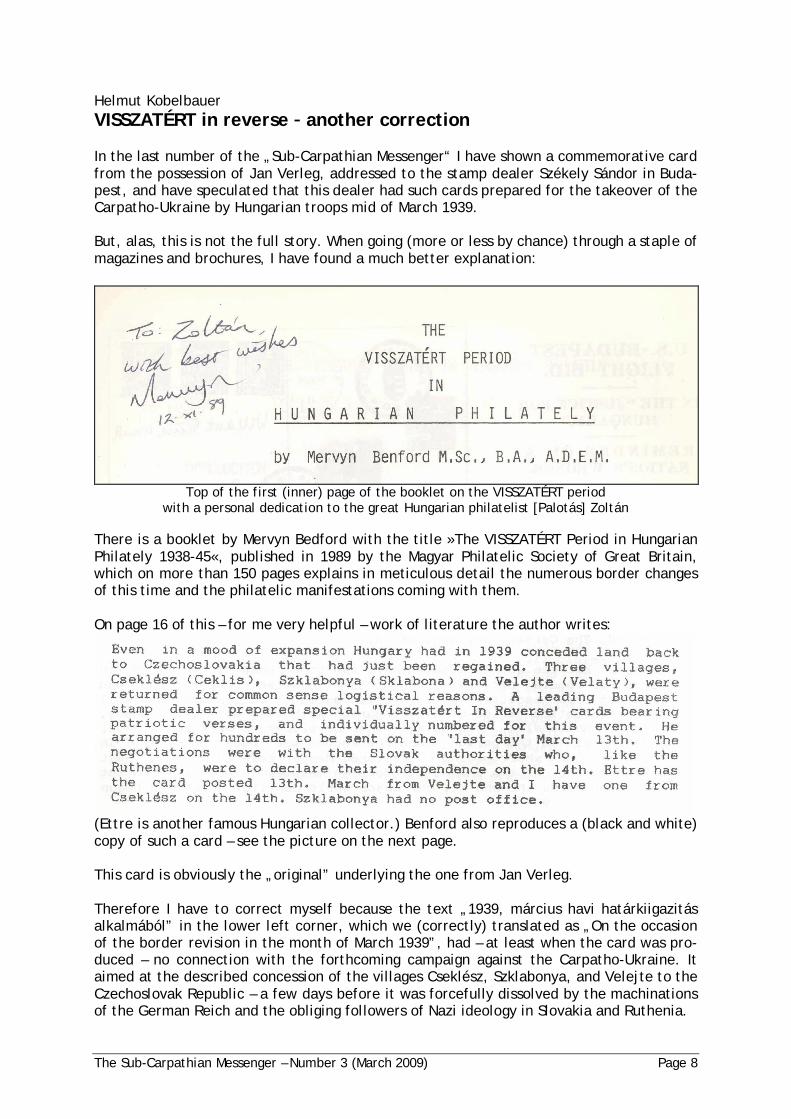
Top of the first (inner) page of the booklet on the VISSZATÉRT periodwith a personal dedication to the great Hungarian philatelist [Palotás] Zoltán
There is a booklet by Mervyn Bedford with the title »The VISSZATÉRT Period in HungarianPhilately 1938-45«, published in 1989 by the Magyar Philatelic Society of Great Britain,which on more than 150 pages explains in meticulous detail the numerous border changesof this time and the philatelic manifestations coming with them.
On page 16 of this – for me very helpful – work of literature the author writes:
(Ettre is another famous Hungarian collector.) Benford also reproduces a (black and white)copy of such a card – see the picture on the next page.
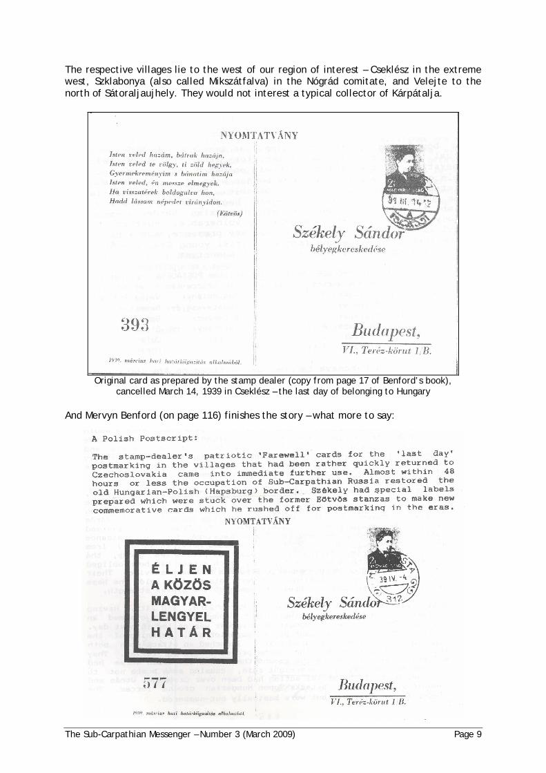
This card is obviously the „original” underlying the one from Jan Verleg.
Therefore I have to correct myself because the text „1939, március havi határkiigazitásalkalmából” in the lower left corner, which we (correctly) translated as „On the occasionof the border revision in the month of March 1939”, had – at least when the card was pro-duced – no connection with the forthcoming campaign against the Carpatho-Ukraine. Itaimed at the described concession of the villages Cseklész, Szklabonya, and Velejte to theCzechoslovak Republic – a few days before it was forcefully dissolved by the machinationsof the German Reich and the obliging followers of Nazi ideology in Slovakia and Ruthenia.
The Sub-Carpathian Messenger – Number 3 (March 2009) Page 9
The respective villages lie to the west of our region of interest – Cseklész in the extremewest, Szklabonya (also called Mikszátfalva) in the Nógrád comitate, and Velejte to thenorth of Sátoraljaujhely. They would not interest a typical collector of Kárpátalja.
Original card as prepared by the stamp dealer (copy from page 17 of Benford’s book),cancelled March 14, 1939 in Cseklész – the last day of belonging to Hungary
And Mervyn Benford (on page 116) finishes the story – what more to say:
The Sub-Carpathian Messenger – Number 3 (March 2009) Page 10
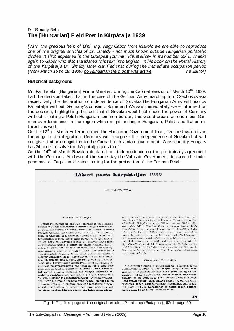
Dr. Simády BélaThe [Hungarian] Field Post in Kárpátalja 1939
[With the gracious help of Dipl. Ing. Nagy Gábor from Miskolc we are able to reproduceone of the original articles of Dr. Simády not much known outside Hungarian philateliccircles. It first appeared in the Budapest journal »Philatelica« in its number 82/1. Thanksagain to Gábor who also translated this text into English. In his book on the Postal Historyof the Kárpátalja Dr. Simády later clarified that during the immediate occupation period(from March 15 to 18, 1939) no Hungarian field post was active. The Editor]
Historical background
Mr. Pál Teleki, [Hungarian] Prime Minister, during the Cabinet session of March 10th, 1939,had the decision taken that in the case of the German Army marching into Czechoslovakiarespectively the declaration of independence of Slovakia the Hungarian Army will occupyKárpátalja without Germany’s consent. Rome and Warsaw immediately were informed onthe decision, highlighting the fact that if Slovakia would get under the power of Germanywithout creating a Polish-Hungarian common border, this would create an enormous Ger-man overdominance in the region which might endanger Hungarian, Polish and Italian in-terests as well.On the 12th of March Hitler informed the Hungarian Government that „Czechoslovakia is onthe verge of disintegration. Germany will recognise the independence of Slovakia but willnot give similar recognition to the Carpatho-Ukrainian government. Consequently Hungaryhas 24 hours to solve the Kárpátalja question.”On the 14th of March Slovakia declared her independence on the preliminary agreementwith the Germans. At dawn of the same day the Voloshin Government declared the inde-pendence of Carpatho-Ukraine, asking for the protection of the German Reich.
Fig. 1: The first page of the original article – Philatelica (Budapest), 82/1, page 39
The Sub-Carpathian Messenger – Number 3 (March 2009) Page 11
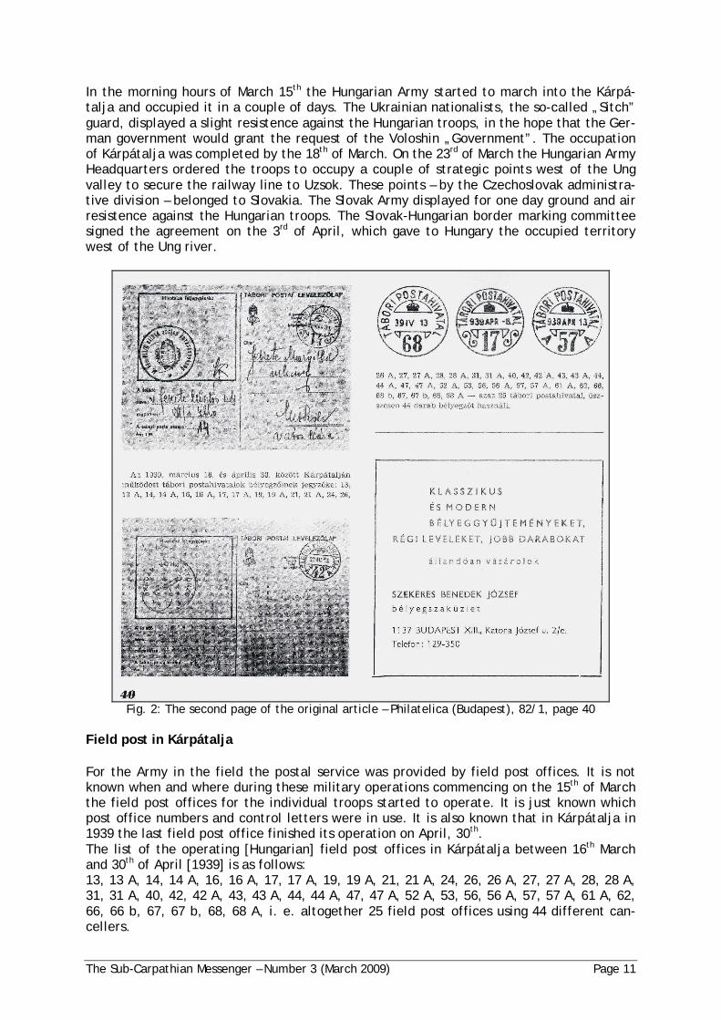
In the morning hours of March 15th the Hungarian Army started to march into the Kárpá-talja and occupied it in a couple of days. The Ukrainian nationalists, the so-called „Sitch”guard, displayed a slight resistence against the Hungarian troops, in the hope that the Ger-man government would grant the request of the Voloshin „Government”. The occupationof Kárpátalja was completed by the 18th of March. On the 23rd of March the Hungarian ArmyHeadquarters ordered the troops to occupy a couple of strategic points west of the Ungvalley to secure the railway line to Uzsok. These points – by the Czechoslovak administra-tive division – belonged to Slovakia. The Slovak Army displayed for one day ground and airresistence against the Hungarian troops. The Slovak-Hungarian border marking committeesigned the agreement on the 3rd of April, which gave to Hungary the occupied territorywest of the Ung river.
Fig. 2: The second page of the original article – Philatelica (Budapest), 82/1, page 40
Field post in Kárpátalja
For the Army in the field the postal service was provided by field post offices. It is notknown when and where during these military operations commencing on the 15th of Marchthe field post offices for the individual troops started to operate. It is just known whichpost office numbers and control letters were in use. It is also known that in Kárpátalja in1939 the last field post office finished its operation on April, 30th.The list of the operating [Hungarian] field post offices in Kárpátalja between 16th Marchand 30th of April [1939] is as follows:13, 13 A, 14, 14 A, 16, 16 A, 17, 17 A, 19, 19 A, 21, 21 A, 24, 26, 26 A, 27, 27 A, 28, 28 A,31, 31 A, 40, 42, 42 A, 43, 43 A, 44, 44 A, 47, 47 A, 52 A, 53, 56, 56 A, 57, 57 A, 61 A, 62,66, 66 b, 67, 67 b, 68, 68 A, i. e. altogether 25 field post offices using 44 different can-cellers.

The Sub-Carpathian Messenger – Number 3 (March 2009) Page 12
Helmut KobelbauerThe »P í Pluk 45 Rumunský « was stationed in Chust
Continuing the article by Juan Page and me from the last number, I think I can prove (or atleast strongly support the argument) that the 45th Infantry Regiment which carried theextra name Rumunský” was stationed in Chust.
Fig. 1: Military barracks near Chust (around 1928)
The idea that there might be a connection between this military unit and Chust came tome when I remembered that I had some picture postcards from Chust showing military in-stallations but had never been able to find out which unit was stationed there. (The unitsfrom U horod and Muka evo, on the other hand, are established.) I am showing two suchcards, one written in 1928, the other in 1936, with pictures of the respective barracks.
Fig. 2: The barracks in Chust (around 1936)

The Sub-Carpathian Messenger – Number 3 (March 2009) Page 13
Checking my picture postcards from this town more thoroughly, I have found the followingitems:
Fig. 3: From a card written in 1935
Fig. 3a: The sender’s address (enlargened)
On a card written on November 17, 1935 the sender gives his name and then his currentaddress as vojín aspirant, 45 p. pl. 5. rota | Chust Pod. Rus.” which – in long form andtranslated – means Military candidate, 45th Infantry Regiment, 5th Company | Chust Sub-Carpathia”.
Fig. 4: Written part of another card (1937)
And I have another card, written May 19, 1937, with again the sender’s address includingthe text „p . pl. 45 „R” Chust.” where the additional „R” might stand for „Rumunský”.
I would conclude from this evidence that the 45th Infantry Regiment at least from 1935 onwas stationed at Chust, was there still in 1937, and would surmise that it was still in Chustin autumn 1938 when the general mobilization of the Czechoslovak troops was declared.
What do you think?
The Sub-Carpathian Messenger – Number 3 (March 2009) Page 14
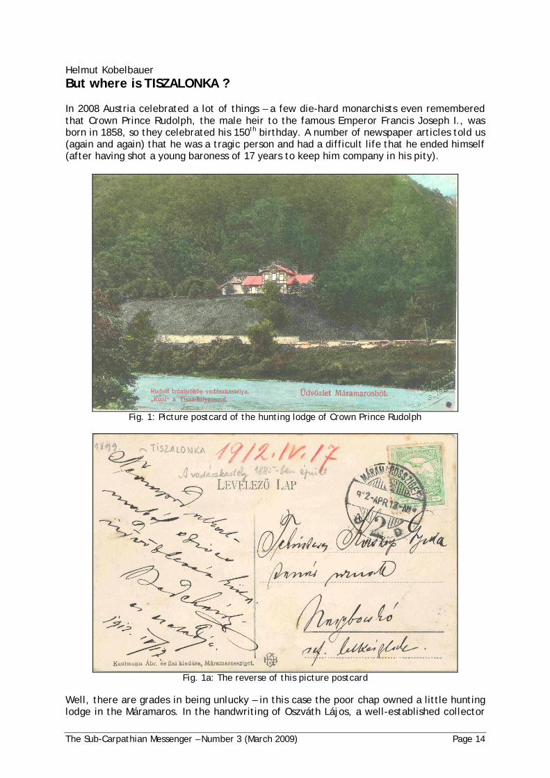
Helmut KobelbauerBut where is TISZALONKA ?
In 2008 Austria celebrated a lot of things – a few die-hard monarchists even rememberedthat Crown Prince Rudolph, the male heir to the famous Emperor Francis Joseph I., wasborn in 1858, so they celebrated his 150th birthday. A number of newspaper articles told us(again and again) that he was a tragic person and had a difficult life that he ended himself(after having shot a young baroness of 17 years to keep him company in his pity).
Fig. 1: Picture postcard of the hunting lodge of Crown Prince Rudolph
Fig. 1a: The reverse of this picture postcard
Well, there are grades in being unlucky – in this case the poor chap owned a little huntinglodge in the Máramaros. In the handwriting of Oszváth Lájos, a well-established collector

The Sub-Carpathian Messenger – Number 3 (March 2009) Page 15
of picture postcards from our area of interest, there is a remark that the hunting lodge wasnear Tiszalonka. But where is Tiszalonka?
You don’t care about Tiszalonka, I know. But if you did, how would you find it? (This is thechallenging part.)
The first approach is to use Ritter or Webersik. Ever heard of them? The first is »Rittersgeographisch-statistisches Lexikon« of 1905-1906 (9th edition) which is available on CD-ROMfrom Winfried Bogon ([email protected]) and has cost me 24,90 Euro. And the second is aheavy book with nearly 1000 pages, a re-print of Gottlieb Webersik: »Geographisch-statisti-sches Weltlexikon« from 1908. (A bit more costly – around 50 Euro.)
You see, we are not the first to have this (minor) problem of not knowing where Tiszalonkais. Probably thousands of post officials of low rank had this problem before – to see thename of a hamlet included in some address and having to find out where this thing is. Soclever people made a bit of business by gathering this information and supplying books(encyklopedias) for this purpose. (Today we just go over to the ever-ready computer andbrowse the world wide web.)
In this case my CD-ROM failed to work and Webersik has nothing on Tiszalonka. Don’tdespair! We will try Lonka – the „Tisza” is just a (big) river, and has been added to a lot ofnames to indicate that the respective locations lie at or near the river.
Ah, on page 514 we find:
Lonka, 1961, Gem. in Ung., Kom. Mármaros, Bz. Tiszavölgy, P. Nagy-Bocskó, E. (Mármaros-Sziget — Körösmez ).
But what does this mean? (It’s German – sort of, at least.)
Lonka has 1961 inhabitants – well, it had so many inhabitants at the last counting (1890)before the publication of the book, is a village in Hungary, in the county of Mármaros, inthe district of Tiszavölgy, the nearest post office is in Nagy-Bocskó, and it can be reachedthrough the given railway line. What more would you want?
But where is it? Where can I find it on a map?
Forget (in general – there are some exceptions) maps from recent times. We talk about anarea where names have changed (and not only once), borders have been moved forwardand backwards and sideways, and recent maps don’t show you all this history.
So we need an „old” map. How old? Well, it depends, but 1910 would be a good year. Inthis year the Austro-Hungarian army got new maps from its „Militär-Geographisches Insti-tut”, i. e. the geographical institute providing military maps. This was the so-called „DritteDurchmusterung” (3rd Survey) and the Army a few years later used these very maps in theFirst World War. At those times they were secret, of course, and had to be carried aroundin heavy wooden boxes with a lot of steel protecting each box. But they hold all the „old”place names that we are interested in.
Good luck has it that a Hungarian historical institute has scanned in exactly these maps,and they are available for (download or) consultation on the Internet. I do not know whe-ther there is still some copyright on these maps, but because nearly 100 years have passedsince their production, I think we will not be prosecuted if we use them occasionally. (Youcan „cut and paste” from such maps – very nice for including cut-outs in some article.)

The Sub-Carpathian Messenger – Number 3 (March 2009) Page 16
The URL you need is http://lazarus.elte.hu/hun/digkonyv/topo/3felmeres.htm - you thensee a large-scale map with a town’s name per cell, and clicking onto the respective celldownloads the map (part) as a JPG file. The cells covering the Kárpátalja are 40-48, 40-49,41-48, 41-49, 42-48.
The map format is VERY unusual (for us), so please do not try to print-out such a map. Youhave to load it into a proper tool (e.g. IrfanView), zoom-in until you can recognize details,navigate around until you have found the spot of interest, and then ... cut-and-paste!
Fig. 2: Cut-out from the 1910 map – Lonka in the middle lower third, Jagdschloss up the river
We all have learned that there is no King’s way to mathematics. Well, for our search thereis one. If – and this is the hard part – you have a copy of good ol’ Lelkes. Another thickbook, again nearly 1000 pages. Its (rather unpronouncable) name is »Magyar Helységnév-Azonosító Szótár« from 1998, collected and written by Lelkes György. It is THE dictionary(lexicon) of ALL place names in (Historical) Hungary. An absolute must – when you can getit. Currently it is out of print but I hope that there will be a re-print REAL SOON NOW.
In the Lelkes you simply find everything. Absolutely amazing.
On page 595:Tiszalonka Lonka
On page 369 :LONKA Máramaros vm. Tiszavölgyi j. (szkh. Rahó) 2385 Ukr, ném és m lakos; Lonka <LR>,Kis-Lonka <FE>, Kislonka, Tiszalonka (1943); ukr: Luhé <LR>, Lunked <LR>; a helység É-i,Tisza-jobbparti része: Lug (orosz név), Luh [U]; ill. D-i Tisza-balparti része: Lunca la Tisa[R] ((1177))
A bit of Hungarian is another must in our business: In 1910 the village had 2385 Ukrainian,German and Hungarian inhabitants; its historical name is Lonka or (another source) Kis-Lonka; during the 1939/1944 period its name was Kislonka or Tiszalonka; in Ukrainian it isLuhé or (another source) Lunked; nowadays it is separated into a part north of the Tiszawith the name Luh ( ) in the Ukraine and a part south of the Tisza with the nameLunca la Tisa in Romania. And on the map nr. 17 (for the Máramaros county) Lonka is easyto find. Yes we can!