The road less traveled – an eclectic career path in …. Peirce, The road less traveled...p i c t...
8
The road less traveled – an eclectic career path in geophysics John Peirce GEDCO, Calgary, Alberta, Canada So how does a kid from Cape Cod end up spending his career in the oil patch in Calgary? I spent summers in high school canoeing on long trips in the North Woods of Maine and decided that forestry would be a good career that would allow me to be outside a lot. When I talked with people in the forestry field, they suggested majoring in geology as an undergraduate and then going to grad school in forestry. I went to university at Dartmouth College in New Hampshire, majored in geology, and found it so interesting that I never looked at forestry again! But I was lucky to go into the field at an exciting time and have great professors. For example, we spent three weeks in Central America researching volcanoes as part of our field training (Figure 1). When I started in geology, plate tectonics was a theory “not suitable for publication in a serious scientific journal,” to quote a review of a paper of the time. I found the whole geosynclinal concept of mountain building rather hard to accept. Then along came plate tectonics and the Wilson Cycle, and suddenly things made sense. Plate tectonics as a working theory became widely accepted at the meeting of the American Geophysical Union in June of 1967 when the overwhelming magnetic evidence for sea floor spreading was presented in a series of landmark talks. I was lucky enough to be in Iceland at that time, working for my first geophysics professor, Bob Decker, setting up a survey line across the southern rift zone of Iceland (Figure 2) so we could measure spreading rates on the ground. It was a fantastic experience to be on the cutting edge of plate tectonics research while still an undergraduate! After Dartmouth, I joined the US Navy for four years and served as a nuclear engineer on a missile submarine (Figure 3). Looking back, it still seems strange to realize that at age 25, with only a few years of experience, I was one of the senior officers in the engineering department and knew more about operating the ship’s diving systems than almost anyone else on the ship. That experience taught me a lot about my personal limits – and helped me to decide what I did not want to do with my life! I’d gone into the Navy partly because I’ve always been fasci- nated by the ocean. After the Navy the best way to combine that interest with the excitement of the new field of plate tectonics research was to go to grad school in marine geophysics. I was very fortunate to be accepted into the M.I.T.-Woods Hole Oceanographic Institution Joint Program in Oceanography as a Ph.D. candidate. When I first arrived at M.I.T., both my advisors were at sea, so I met with Frank Press (arguably the most famous seismologist 20 CSEG RECORDER June 2008 Continued on Page 21 Figure 1. Volcan Pacaya, Guatemala, in eruption, November, 1966. This picture was taken during my geology field course. Figure 2. The rift zone in southern Iceland, looking NNE, with the structure of rift valley faulting clearly evident, June 1967. The lake is Thingvalavatn (lake of the valley of the Parliament). The world’s first parliament, in the year 936 AD, was held at the north end of the lake. Figure 3. John (on the right) as a young Engineering Officer of the Watch on patrol in his submarine, Christmas Eve, 1970.
Transcript of The road less traveled – an eclectic career path in …. Peirce, The road less traveled...p i c t...
The road less traveled – an eclectic careerpath in geophysicsJohn PeirceGEDCO, Calgary, Alberta, Canada
So how does a kid from Cape Cod end up spending his careerin the oil patch in Calgary?
I spent summers in high school canoeing on long trips in theNorth Woods of Maine and decided that forestry would be agood career that would allow me to be outside a lot. When Italked with people in the forestry field, they suggestedmajoring in geology as an undergraduate and then going tograd school in forestry. I went to university at DartmouthCollege in New Hampshire, majored in geology, and found itso interesting that I never looked at forestry again!
But I was lucky to go into the field at an exciting time andhave great professors. For example, we spent three weeks inCentral America researching volcanoes as part of our fieldtraining (Figure 1).
When I started in geology, plate tectonics was a theory “notsuitable for publication in a serious scientific journal,” toquote a review of a paper of the time. I found the wholegeosynclinal concept of mountain building rather hard toaccept. Then along came plate tectonics and the Wilson Cycle,and suddenly things made sense.
Plate tectonics as a working theory became widely acceptedat the meeting of the American Geophysical Union in June of1967 when the overwhelming magnetic evidence for sea floorspreading was presented in a series of landmark talks. I waslucky enough to be in Iceland at that time, working for myfirst geophysics professor, Bob Decker, setting up a surveyline across the southern rift zone of Iceland (Figure 2) so wecould measure spreading rates on the ground.
It was a fantastic experience to be on the cutting edge of platetectonics research while still an undergraduate!
After Dartmouth, I joined the US Navy for four years andserved as a nuclear engineer on a missile submarine (Figure3). Looking back, it still seems strange to realize that at age 25,with only a few years of experience, I was one of the senior
officers in the engineering department and knew more aboutoperating the ship’s diving systems than almost anyone elseon the ship. That experience taught me a lot about mypersonal limits – and helped me to decide what I did notwant to do with my life!
I’d gone into the Navy partly because I’ve always been fasci-nated by the ocean. After the Navy the best way to combinethat interest with the excitement of the new field of platetectonics re s e a rch was to go to grad school in marinegeophysics. I was very fortunate to be accepted into theM.I.T.-Woods Hole Oceanographic Institution Joint Programin Oceanography as a Ph.D. candidate.
When I first arrived at M.I.T., both my advisors were at sea, soI met with Frank Press (arguably the most famous seismologist
20 CSEG RECORDER June 2008
Continued on Page 21
F i g u re 1. Volcan Pacaya, Guatemala, in eruption, November, 1966. Thisp i c t u re was taken during my geology field course.
F i g u re 2. The rift zone in southern Iceland, looking NNE, with the structure ofrift valley faulting clearly evident, June 1967. The lake is Thingvalavatn (lakeof the valley of the Parliament). The world’s first parliament, in the year 936AD, was held at the north end of the lake.
F i g u re 3. John (on the right) as a young Engineering Officer of the Watch onp a t rol in his submarine, Christmas Eve, 1970.
June 2008 CSEG RECORDER 21
in the US at the time, and later a White House Science A d v i s o r ) .He took one look at my transcript, which was weak on both mathand physics, and blurted out “How the Hell did you ever getaccepted here?!” He quickly apologized for his candor, andassigned me to a year of advanced calculus for engineers (whichnearly killed me!) and a sophomore class on Physics of Wa v e s ,which turned out to be probably the best course I have ever takena n y w h e re .
The Joint Program was everything I could have asked for – greatcourses, the chance to work with leading scientists in platetectonics, other students who have become lifelong friends, andthe chance to go to sea. My most memorable cruise was twomonths at sea mapping the triple junction at the southern end ofthe Mid-Atlantic Ridge (Figure 4).
During this cruise we saw Bouvet Island, a glacier-coveredvolcanic island, which has the distinction of being that piece ofland on Earth which is farthest from any other), once had morethan 200 icebergs on radar, managed to inadvertently anchorourselves in 5000 m of water when a core got stuck in the bottom,and experienced a magnitude 5.4 earthquake nearly right underthe ship!
I did my thesis on the paleomagnetics of cores from the Deep SeaDrilling Project. The topic was measuring the northward motionof India from its separation from Antarctica through its collisionwith Asia. As I started looking for jobs,I was attracted to Dalhousie Universityin Halifax and Jim Hall’s paleomag-netics lab there. My wife, Nancy, who isfrom Vancouver, and I were starting ourrelationship then, and it was a lot easierfor me to move north than for her tomove south, so I ended up at Dalhousieas an Assistant Pro f e s s o r, teachingIntroductory Geology and a graduatecourse in Marine Geology andGeophysics. During my second year atDal, my long-time business partner,Andreas Cordsen, showed up in mygraduate class, and a lifelong friend-ship began.
During my time at Dalhousie I hadinvited someone from Petro-Canada tocome out to give some lectures to myclass and show us some seismic datafrom the East Coast. Willys Reed got theassignment and we had an exciting fewdays together.
When it came time for me to look for ajob the following year, I wrote to Wi l l y sasking about job opportunities and gotback a very polite “Dear John” letter, soI was looking elsewhere. Two monthsl a t e r, Willys called unexpectedly, andmuch to my surprise, he off e red me a jobto start up a gravity and magneticsg roup at Petro-Canada in Calgary. “But Idon’t know anything about the oil
industry!” I stammered. To which he replied, “That’s OK – we’llteach you!” Willys not only taught me a lot about the industry, buthe also made sure that I had access to any course I wanted, andmost importantly, he taught me a great deal about managingpeople by his example. He was one of the great mentors in my life.
I clearly remember my first trip to the field to QC a gravitysurvey in the Colville Hills, 200 miles north of Great Bear Lake inthe N.W.T. (Figures 5 and 6). Mike McCombe was the gravity
Focus Article Cont’d
Continued on Page 22
F i g u re 4. Seas near Bouvet Island, at the southern end of the Mid-Atlantic Ridge(~54° S). February, 1974 (mid-summer in those latitudes!).
The road less traveled…Continued from Page 20

22 CSEG RECORDER June 2008
operator, and I spent a couple of days riding around behind himon a snowmobile at -45°C. What a cold way to earn a living!
I clearly recall that the day I flew out from camp it was -56°C. Iwas the only one going out on the DC-3 at the end of the day.Because it was -40°C in the passenger compartment, as soon aswe took off from the ice runway I went up to the cockpit. The oilpressure gauge was fluttering, and we promptly blew every oil
ring in the port engine. With oil streaming off the wing, the pilotcalmly feathered the prop as we lost 2000’ of altitude and 30knots of speed.
When things were evidently under control, I leaned over to askin my calmest possible voice, “What is our new ETA (estimatedtime of arrival) in Norman Wells at our reduced speed?” Withoutmissing a beat, he answered “Don’t you mean ETI – estimatedtime of impact?!” After that comeback I didn’t have much to sayfor the rest of the flight!
Two projects that were particularly interesting during those firstyears at Petro-Canada were the first exploration of the SouthChina Sea and a foreign aid project exploring the Rukwa Rift inTanzania. The South China Sea involved four huge blocks with33 companies vying for exploration licenses (Figure 7). Thecombination of the seismic data and the gravity/magnetic dataallowed me to work out that the rifting in the South China Seawas caused by the extrusion of the SE Asia Block as Indiacollided with Asia. The timing of this event in the South ChinaSea agreed exactly with the slowing down of India as the colli-sion started, which I had documented in my thesis. It was a greatfeeling to use my thesis work in such a practical application.
Looking back, I still feel that this was some of the best work Ihave ever done. I really wanted to publish it, but I realized thatwith 33 companies involved, there was no chance. Consequently,I coined Peirce’s Law of Publication, which states that thechances of getting confidential information released for publica-tion are proportional to 1/2N, where N is the number of compa-nies involved. 1/233 is pretty close to zero, so I didn’t even ask forpermission to publish!
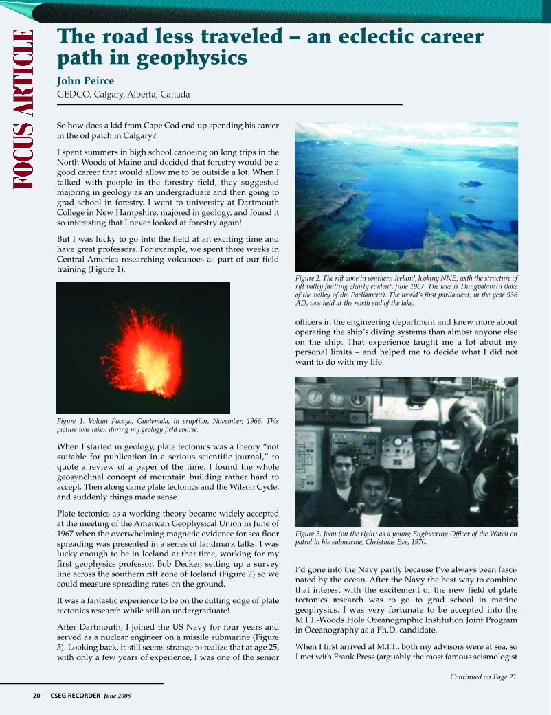
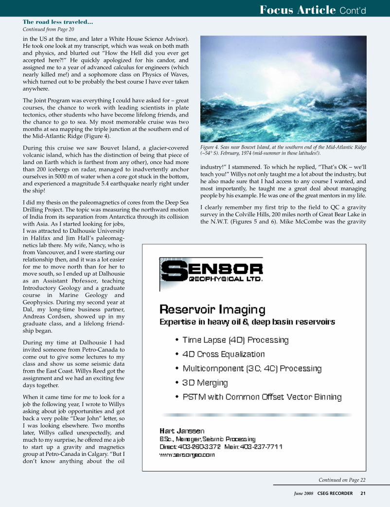
The Rukwa Rift project was done for Petro-Canada InternationalAssistance Corporation (PCIAC). It was a huge gravity survey,covering 80,000 km2 in the East African Rift. Mike McCombe (theone who was driving the snowmobile at -45°C) was the chiefgravity operator. The survey involved helicopters and a cata-maran contraption (Figure 8) that supported the underwatergravity meter.
The results (Peirce and Lipkov, 1988; Figure 9) were excellent,and our models were borne out by later slim hole drilling by
Focus Article Cont’dThe road less traveled…Continued from Page 21
Continued on Page 23
F i g u re 5. Mike McCombe, operating a gravity meter near Lac Maunoir, NWT,F e b r u a r y, 1978. Te m p e r a t u re was about -450 C.
F i g u re 6. Looking along a seismic line on the same field program as Figure 4.
F i g u re 7. Petro-Canada presentation to Chinese National Oil Company in Beijing,during the first round of bids for the South China Sea, March, 1981.
June 2008 CSEG RECORDER 23
Focus Article Cont’d
Shell. Unfortunately there was insufficient source rock, so explo-ration in the Rukwa area was short lived.
In 1984, Tom LaFehr, who was the first Chair of the EditorialBoard of The Leading Edge, asked me to join the Board. It was awonderful chance to get to know more geophysicsts from otherparts of the world and the SEG staff in Tulsa, especially DoloresProubasta and Dean Clark. I particularly remember hosting aTLE Board meeting in Calgary at theCSEG Convention in 1985, when wehad a huge May blizzard. No one onthe TLE Board ever let me forget that Ilive in the frozen north!
When I resigned from the TLE Boardfour years later, I persuaded BrianRussell to take my place, and eversince then there has been one Canadianon the TLE Board, up to and includingSatinder Chopra today.
In 1986, the price of oil crashed andt h e re was anguish all over Calgary aspeople suddenly found themselvesout of a job. I was told to fire my entiregravity/magnetics group, but fortu-nately I was able to engineer some sortof a soft landing for everyone. ErwinEbner was one of those – he became anindependent consultant doing gravityand magnetics as needed with ano ffice at Petro-Canada. I don’t thinkhe still has the office, but he still doesmost of their gravity and magneticswork some 22 years later! And he doesa lot of that work at GEDCO, where hestill does have an office as an inde-pendent consultant.
After the 1986 debacle, I ended up asSupervisor of the World Basin StudiesGroup in a newly formed InternationalExploration Division at Petro-Canada.
Continued on Page 24
F i g u re 8. Catamaran used for gravity acquisition on Lake Rukwa, Tanzania, 1983.The underwater gravity meter is the round object in the center of the boat.
F i g u re 9. Cover of the final report, viewing the Rukwa Rift from the NW andshowing it as a deep and narrow half-graben reaching 6.5 km depth. The width ofthe lake at its SE end is about 20 km.
The road less traveled…Continued from Page 22

24 CSEG RECORDER June 2008
That was an exciting time technically as we worked all over theworld. I had the privilege of working with people like TonyTankard, Hugh Balkwill and Ian McIlreath. But my biggest chal-lenge was when I was given only one hour to explain the geologyof Western Canada Sedimentary Basin to a visiting group ofChinese geoscientists. I nearly choked at the enormity of the taskuntil my boss, Dave Thomas, suggested that I approach it asthough it were an international basin and explain it from a basincycle analysis perspective. With that insight, not only did the jobbecome manageable, but my understanding of the basin doubledovernight as I reviewed the geology with new eyes!
In 1988 I had the privilege to take a six month leave of absence tobe Co-Chief Scientist with Dr. Jeff Weissel (an Aussie researchscientist working in the U.S.) on Leg 121 of the Ocean DrillingProgram in the Indian Ocean. We had 35 scientists from 23 coun-tries speaking nine different languages on board the drill ship,ranging from graduate students to some very senior scientists.We drilled first on Broken Ridge, 1000 km west of Perth,Australia. We drilled through a phenomenal Cretaceous-Tertiary(K-T) boundary section that surprised us all because of the veryhigh productivity and high sedimentation rates. It was as close toa religious experience as I have ever had to look at the corechange from almost pure carbonate in the uppermost Cretaceousto 5 cm of black material at the K-T boundary. In that part of theocean 95% of life, both surface and bottom dwelling planktonicplants and animals, died as the ocean became acidified (presum-ably because of the meteor impact 66 million years ago atChicxulub in Mexico). The few species that survived weredwarfed because of the environmental stress, but within a fewcm of core, these species grew in size during the lowermostPaleocene and diversified to fill the wide open ecological niches.I was incredibly grateful that I had taken a course in micropale-ontology in grad school so that I could keep up with the fivepaleontologists on board as they developed these results. Afterthe Broken Ridge drilling, we went on to drill along theNinetyeast Ridge, the subject of my thesis. Twelve years after Idefended my thesis, I finally got to visit my thesis area!
I returned to Petro-Canada and was assigned to work in WesternCanada for the first time. I had the good fortune to work forBenoit St.-Hilaire and Thomas Chen, who taught me how to doprospect scale exploration in the complex business environmentof Western Canada. I particularly remember having the chance tofinally take a course in seismic processing. Pat McKenny (then atVeritas) took a few of us under his wing for a couple of weeks,and I learned skills that have stood me in good stead ever since.
But life at Petro-Canada was always life at a big company whereone’s future depended more on others’ decisions than on one’sown abilities. The entrepreneurial spirit in me was pushing to behatched. My longtime friend, Andreas Cordsen, then at Norcen,was finding much the same thing. At his suggestion, we investi-gated going into business together. When we compared our listsof contacts, we found there was very little overlap – a doublenetwork if you will. I clearly remember deciding to take the threeleading geophysical consultants of the day out to lunch (sepa-rately). They were John Boyd, Sudhir Jain, and Ralph Lundberg.I said to each of them: “Andreas and I are thinking of going intothe consulting business together, and we will probably end upcompeting with you, but notwithstanding that, do you have anyadvice for us?” Their generosity in offering support was
amazing, and it really made me appreciate what a close frater-nity we geophysicists share. Ralph Lundberg had the mostcogent advice: “John, for 25 years as a consultant I’ve been 2weeks away from unemployment. If you can’t stand the heat,don’t go in the kitchen!”
We made the rounds of some of our contacts, and receivedencouragement, but no promises of work. Anyhow, we made thejump with no firm work lined up and opened GEDCO’s doors inJanuary of 1991. Frank van Humbeck was particularly encour-aging, and he and Tai Ng at Can Hunter did give us a couple ofprojects early on, for which we were very grateful. Andreas andI had the good fortune to share the same value system. That hasbeen a key factor that has made our partnership so successful.
When we started GEDCO, my wife, Nancy, insisted that we planon the Peirces taking six months off in 1994 so that we couldtake our young kids to a developing country to do volunteerwork and to see how the rest of the world lives. I protested thatwe couldn’t predict 6 months ahead, let alone 4 years, and wecouldn’t possibly aff o rd such a luxury, but she insisted “If youdon’t have a vision, then it will never happen!” Well, four yearslater she had received a small inheritance and the business wasgoing well, so off we four went to Nepal for four months (Figure10). Our kids were 13 and 11 at the time. We found a contactwith the Helen Keller Institute, and through them ended upworking with a group of blind children at a high school on therim of the Katmandhu valley. We all had a challenging and verymemorable experience.
In early 1995, Peter Duncan, who was on the ContinuingEducation Committee at the Society of ExplorationGeophysicists (SEG), asked Andreas and me to put together acourse on planning land 3D surveys for the SEG. We thought –“This will be great, we’ll get to teach in all sorts of exotic loca-tions around the world!” Well, that first year we taught thecourse four times in Texas. Eventually, we did go further afield.
Our course notes had depended heavily on Mike Galbraith’sexperience from providing support for Seismic Image Software’s(SIS) OMNI 3D™ seismic design program. Eventually thosenotes matured into the book “Planning and Operating Land 3DSurveys” (Cordsen et al., 2000), published by the SEG in 2000,
Focus Article Cont’dThe road less traveled…Continued from Page 23
Continued on Page 25
F i g u re 10. Mt. Dhaulaguri (7th highest mountain in the world at 8167 m) andBuddhist prayer flags, taken from trail to Poon Hill, Nepal. October, 1994.
June 2008 CSEG RECORDER 25
when the SEG convention was in Calgary. About then I retired from teaching the course because I was no longer doing that kind ofwork, and Peter Eick from Conoco Phillips took my place as Andreas’s teaching partner. Today, eight years later, they are still teachingthe course together.
I n t e re s t i n g l y, just as we were developing the 3D course, GPS navigation revolutionized the airborne magnetics business, andGEDCO’s business became mostly aeromag for a few years. The concept of High Resolution A e roMagnetic (HRAM) data wascoined by Erwin Ebner, and we began our long-standing effort at trying to map intra-sedimentary faulting using magnetics. Weh i red Bob Charters, Serguei Goussev and Hassan Hassan as magnetic interpreters and we had all the work we could handle flyingand interpreting new airborne surveys.
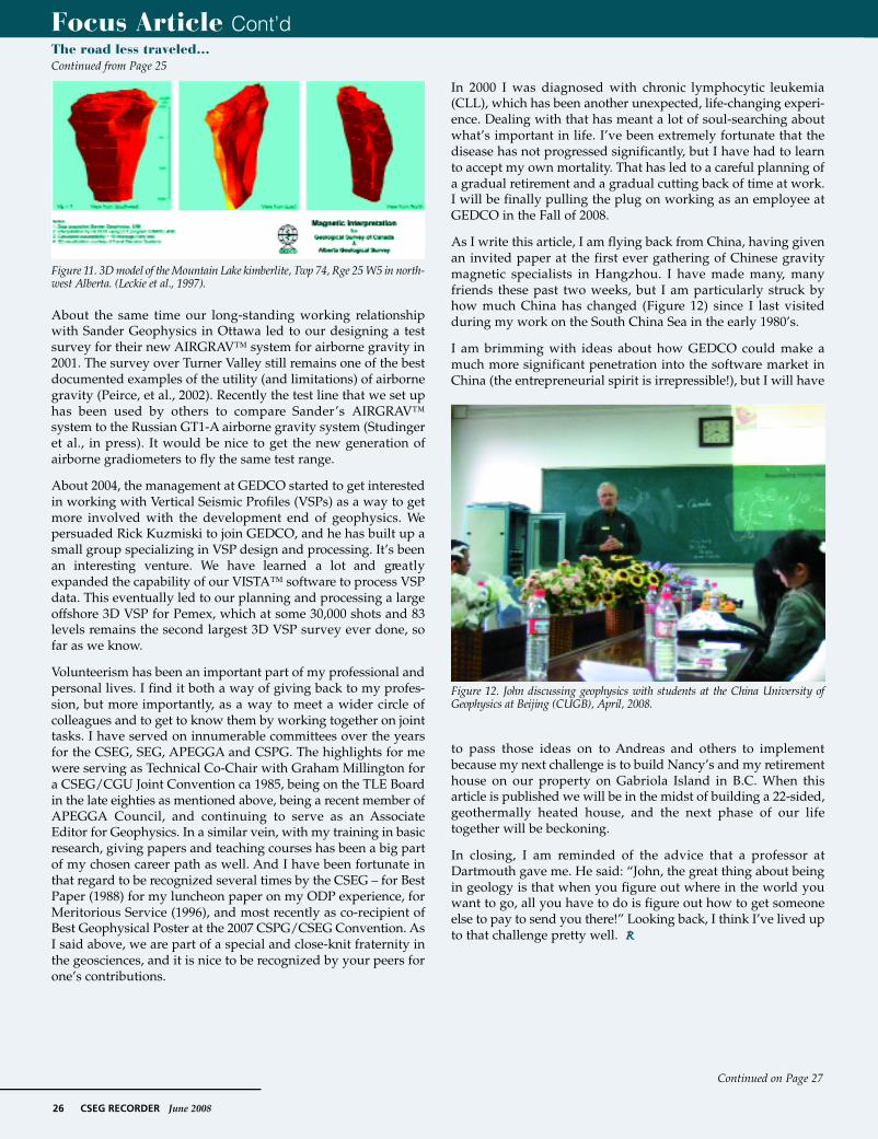
Somewhere early in this sequence, we were doing work for Rob Pryde of AEC near Loon Lake and found these strange magneticanomalies that looked like big oilwells. We soon figured out that wehad discovered a field of kimberlitepipes, and that eventually becamethe beginning of the Alberta diamondplay (Figure 11). Unfortunately therewere not enough diamonds to makethese pipes economic. I regret notasking for a little vial of microdia-monds as a memento. Actually, thereprobably were not enough microdia-monds in total to make suchmementos for all those involved.
In early 1997, Rob Stewart asked TedGlenn and me to organize a specialmeeting on this new concept of HighResolution A e roMagnetics, whichresulted in the 1997 CSEG HRAMForum that was attended by peoplefrom all over the world. The papersfrom that meeting became the lastissue of the CSEG Journal ofExploration Geophysics (Peirce et al.,1998), but it was a landmark volume.
About that time, John Rhodes andBob Charters came up with the ideaof translating magnetic depth solu-tions into SEGY format (MaFIC) sothat we could put the magneticresults directly in the hands of theseismic interpreter. It was a brilliantexample of lateral thinking.
In 2000 our friendship with MikeGalbraith led to GEDCO merg i n gwith Seismic Image Software, andGEDCO began its transformationf rom a consulting company to ageophysical software company. Notonly did we instantly double in size,but the whole nature of our workbegan to change, with more and moreof our consulting work becomingrelated to our two software packages,V I S TA™ (2D/3D/VSP Seismic DataP rocessing) and OMNI 3D™ (SeismicSurvey Design and Modeling).
Focus Article Cont’dThe road less traveled…Continued from Page 24
Continued on Page 26
26 CSEG RECORDER June 2008
About the same time our long-standing working relationshipwith Sander Geophysics in Ottawa led to our designing a testsurvey for their new AIRGRAV™ system for airborne gravity in2001. The survey over Turner Valley still remains one of the bestdocumented examples of the utility (and limitations) of airbornegravity (Peirce, et al., 2002). Recently the test line that we set uphas been used by others to compare Sander’s AIRGRAV™system to the Russian GT1-A airborne gravity system (Studingeret al., in press). It would be nice to get the new generation ofairborne gradiometers to fly the same test range.
About 2004, the management at GEDCO started to get interestedin working with Vertical Seismic Profiles (VSPs) as a way to getmore involved with the development end of geophysics. Wepersuaded Rick Kuzmiski to join GEDCO, and he has built up asmall group specializing in VSP design and processing. It’s beenan interesting venture. We have learned a lot and gre a t l yexpanded the capability of our VISTA™ software to process VSPdata. This eventually led to our planning and processing a largeoffshore 3D VSP for Pemex, which at some 30,000 shots and 83levels remains the second largest 3D VSP survey ever done, sofar as we know.
Volunteerism has been an important part of my professional andpersonal lives. I find it both a way of giving back to my profes-sion, but more importantly, as a way to meet a wider circle ofcolleagues and to get to know them by working together on jointtasks. I have served on innumerable committees over the yearsfor the CSEG, SEG, APEGGA and CSPG. The highlights for mewere serving as Technical Co-Chair with Graham Millington fora CSEG/CGU Joint Convention ca 1985, being on the TLE Boardin the late eighties as mentioned above, being a recent member ofAPEGGA Council, and continuing to serve as an AssociateEditor for Geophysics. In a similar vein, with my training in basicresearch, giving papers and teaching courses has been a big partof my chosen career path as well. And I have been fortunate inthat regard to be recognized several times by the CSEG – for BestPaper (1988) for my luncheon paper on my ODP experience, forMeritorious Service (1996), and most recently as co-recipient ofBest Geophysical Poster at the 2007 CSPG/CSEG Convention. AsI said above, we are part of a special and close-knit fraternity inthe geosciences, and it is nice to be recognized by your peers forone’s contributions.
In 2000 I was diagnosed with chronic lymphocytic leukemia(CLL), which has been another unexpected, life-changing experi-ence. Dealing with that has meant a lot of soul-searching aboutwhat’s important in life. I’ve been extremely fortunate that thedisease has not progressed significantly, but I have had to learnto accept my own mortality. That has led to a careful planning ofa gradual retirement and a gradual cutting back of time at work.I will be finally pulling the plug on working as an employee atGEDCO in the Fall of 2008.
As I write this article, I am flying back from China, having givenan invited paper at the first ever gathering of Chinese gravitymagnetic specialists in Hangzhou. I have made many, manyfriends these past two weeks, but I am particularly struck byhow much China has changed (Figure 12) since I last visitedduring my work on the South China Sea in the early 1980’s.
I am brimming with ideas about how GEDCO could make amuch more significant penetration into the software market inChina (the entrepreneurial spirit is irrepressible!), but I will have
to pass those ideas on to Andreas and others to implementbecause my next challenge is to build Nancy’s and my retirementhouse on our property on Gabriola Island in B.C. When thisarticle is published we will be in the midst of building a 22-sided,geothermally heated house, and the next phase of our lifetogether will be beckoning.
In closing, I am reminded of the advice that a professor atDartmouth gave me. He said: “John, the great thing about beingin geology is that when you figure out where in the world youwant to go, all you have to do is figure out how to get someoneelse to pay to send you there!” Looking back, I think I’ve lived upto that challenge pretty well. R
Focus Article Cont’d
Continued on Page 27
F i g u re 12. John discussing geophysics with students at the China University ofGeophysics at Beijing (CUGB), April, 2008.
F i g u re 11. 3D model of the Mountain Lake kimberlite, Twp 74, Rge 25 W5 in north-west Alberta. (Leckie et al., 1997).
The road less traveled…Continued from Page 25

ReferencesCordsen, A., Galbraith, M. and Peirce, J.W., 2000,Planning and Operating Land 3D Surveys: Societyof Exploration Geophysicists, 204 pp.
Leckie, D. A., Kjarsgaard, B., Peirce, J. W., Grist, A.M., Collins, M., Sweet, A., Stariuk, L., Tomica, M.A., Eccles, R., Dufresne, M., Fenton, M. M.,Pawlowicz, J. G., Balzer, S. A., McIntyre, D. J., andMcNeil, D. H., 1997, Geology of a Late CretaceousPossible Kimberlite at Mountain Lake, Alberta –C h e m i s t r y, Petro l o g y, Indicator Minerals,Aeromagnetic Signature, Age, Stratigraphic Positionand Setting: Geological Survey of Canada OpenFile Report 3441, 202 pp.
Peirce, J.W., Glenn, T., and Brown, K., eds., 1998,CSEG HRAM Forum: Canadian Journal ofExploration Geophysics, 34.
Peirce, J.W., and Lipkov, L., 1988, Structural inter-pretation of the Rukwa Rift, Tanzania: Geophysics,53, 824-836.
Peirce, J.W., Sander, S. Charters, R.A., and Lavoie,V., 2002, Turner Valley, Canada – a case history incontemporary airborne gravity: SEG ExpandedAbstracts, 21, 783-787.
Studinger, M., Bell, R., and Fearson, N., in press2008, Comparison of AIRGrav and GT-1A airbornegravimeters for research applications: Geophysics.
June 2008 CSEG RECORDER 27
Focus Article Cont’dThe road less traveled…Continued from Page 26