THE REBUILDING OF THE CENTER OF RIO DE JANEIRO DURING VARGAS PERIOD...
16
15th INTERNATIONAL PLANNING HISTORY SOCIETY CONFERENCE 1 THE REBUILDING OF THE CENTER OF RIO DE JANEIRO DURING VARGAS PERIOD (1930-1945) FERNANDO DINIZ MOREIRA Address: Address: Rua Gal. Americano Freire, 562 ap 101 Recife-PE 51021-120 Brasil e-mail: [email protected] ABSTRACT This paper studies the rebuilding of the center of Rio de Janeiro during the Vargas dictatorship (1937-1945). The replacement of the colonial urban fabric by a new pattern was due to the establishment of building codes regulating from building layouts to architectural details. Developers and architects were obliged to attend these codes.The origins of this process can be found in the plan that the French planner Alfred Agache elaborated for Rio de Janeiro between 1928 and 1930. The implementation of the plan, however, had a tortuous path. Virtually abandoned after presentation, its major ideas were recovered and adapted by the Mayor Henrique Dodsworth, who stayed in power between 1937 and 1945, the years of Vargas dictatorship. Due to political and professional disputes, the plan was reduced to the redevelopment of a central district (Castello Esplanade) and a large boulevard (Presidente Vargas Avenue). However, Dodsworth’s administration resorted to building codes proposed by Agache determining alignment of facades, volumetric unity of blocks and concordance of heights and architectural motifs. The new urban design communicated an intense image of power and discipline through its architectural mass, monumental scale and vast open spaces. It was clearly intended to form of urban scenery, expressing Vargas Regime corporatism, social control, and state regulatory interventionism.This paper explores the role of the building codes in the weaving of urban elements, dynamic forces and desires of patrons, bureaucrats, and architects towards the creation of a modern district. INTRODUCTION During the Vargas dictatorship (1937-1945), the colonial urban fabric of Rio de Janeiro was replaced by a new pattern dictated by building codes from block layouts to architectural details to which developers and architects were obliged to attend. The origins of this process can be found in the plan that the French planner Alfred Agache elaborated for Rio de Janeiro between 1928 and 1930. A milestone in the evolution of Brazilian urbanism, this plan intended to set principles to solve Rio’s functional problems and to provide it with a proper image of a capital. The implementation of the plan, however, had a tortuous path. Virtually abandoned after presentation, its major ideas were recovered and adapted by the Mayor Henrique Dodsworth, whose term from 1937 and 1945 coincided with the years of Vargas dictatorship. Due to political and professional disputes, the plan was reduced to the redevelopment of a central district (Castello Esplanade) and a large boulevard (Presidente Vargas Avenue). However, Dodsworth’s administration resorted to building codes proposed by Agache determining alignment of facades, volumetric unity of blocks and concordance of heights and architectural motifs.
Transcript of THE REBUILDING OF THE CENTER OF RIO DE JANEIRO DURING VARGAS PERIOD...
1 5 t h I N TE RN A T I ON A L P LA N N I N G H I ST O RY S OC I ETY C ON F ER EN C E
1
THE REBUILDING OF THE CENTER OF RIO DE JANEIRO DURING VARGAS PERIOD (1930-1945)
FERNANDO DINIZ MOREIRA
Address: Address: Rua Gal. Americano Freire, 562 ap 101 Recife-PE 51021-120 Brasil e-mail: [email protected]
ABSTRACT
This paper studies the rebuilding of the center of Rio de Janeiro during the Vargas dictatorship (1937-1945). The replacement of the colonial urban fabric by a new pattern was due to the establishment of building codes regulating from building layouts to architectural details. Developers and architects were obliged to attend these codes.The origins of this process can be found in the plan that the French planner Alfred Agache elaborated for Rio de Janeiro between 1928 and 1930. The implementation of the plan, however, had a tortuous path. Virtually abandoned after presentation, its major ideas were recovered and adapted by the Mayor Henrique Dodsworth, who stayed in power between 1937 and 1945, the years of Vargas dictatorship. Due to political and professional disputes, the plan was reduced to the redevelopment of a central district (Castello Esplanade) and a large boulevard (Presidente Vargas Avenue). However, Dodsworth’s administration resorted to building codes proposed by Agache determining alignment of facades, volumetric unity of blocks and concordance of heights and architectural motifs. The new urban design communicated an intense image of power and discipline through its architectural mass, monumental scale and vast open spaces. It was clearly intended to form of urban scenery, expressing Vargas Regime corporatism, social control, and state regulatory interventionism.This paper explores the role of the building codes in the weaving of urban elements, dynamic forces and desires of patrons, bureaucrats, and architects towards the creation of a modern district.
INTRODUCTION
During the Vargas dictatorship (1937-1945), the colonial urban fabric of Rio de Janeiro was replaced by a new pattern dictated by building codes from block layouts to architectural details to which developers and architects were obliged to attend. The origins of this process can be found in the plan that the French planner Alfred Agache elaborated for Rio de Janeiro between 1928 and 1930. A milestone in the evolution of Brazilian urbanism, this plan intended to set principles to solve Rio’s functional problems and to provide it with a proper image of a capital. The implementation of the plan, however, had a tortuous path. Virtually abandoned after presentation, its major ideas were recovered and adapted by the Mayor Henrique Dodsworth, whose term from 1937 and 1945 coincided with the years of Vargas dictatorship.
Due to political and professional disputes, the plan was reduced to the redevelopment of a central district (Castello Esplanade) and a large boulevard (Presidente Vargas Avenue). However, Dodsworth’s administration resorted to building codes proposed by Agache determining alignment of facades, volumetric unity of blocks and concordance of heights and architectural motifs.

C i t i e s , n a t i o n s a n d r e g i o n s i n p l a n n in g h i s t o r y
2
The new urban design communicated an intense image of power and discipline through its architectural mass, monumental scale and vast open spaces. It was clearly intended to form of urban scenery, expressing Vargas Regime corporatism, social control, and state regulatory interventionism and establishing a new pattern for central areas in Brazil.
This paper explores the tense relationship between public and private intentions in the shaping of central Rio and the role of the building codes in the weaving of urban elements, dynamic forces and desires of patrons, bureaucrats, and architects towards the creation of a modern district. The first section of the paper will focus on Agache’s plan for Rio de Janeiro and the second will discuss the fate of the plan. The Castello District and the Presidente Vargas, will be discussed in the third and fourth sections.
ALFRED AGACHE’S PLAN FOR RIO DE JANEIRO
Agache’s plan objective was to solve the city’s functional problems, to provide it with an expression of a capital, and to inculcate Rio’s inhabitants with a social ideal of modern life. The two major points in which Agache focused his attention were circulation and zoning. He proposed a skeleton (ossature) that defined the major lines of the project. In his scheme, a system of expressways, carrefours, and crossings, would make the city fluid. In his scheme, the future Presidente Vargas Avenue is already proposed.
Regarding zoning, Agache affirmed that the urban life of Rio depended on the proper functioning of its parts (areas or district), each of them with a role to play in the city. It was necessary to identify the elements these parts and to distribute them appropriately in the city, establishing correct relationships between them (1930, p.157-159). For each quarter, Agache fixed heights, types of buildings in order to create an urban image and pattern. For him, urbanism was an art of composition that gives each district an image, different from each other, but combined in a coherent and stable image of a modern city (fig.1).
Figure 1- Alfred Agache, Aerial view of the Plan for Rio de Janeiro. in Agache, 1930, p. 137
One of the most meaningful aspects of Agache’s plan was the emphasis on the symbolic and aesthetic in the formation of modern urban centers, commonly monumental and uniform. The two most prominent of his proposals the Gateway

1 5 t h I N TE RN A T I ON A L P LA N N I N G H I ST O RY S OC I ETY C ON F ER EN C E
3
of Brazil, a vast square facing the sea and surrounded by uniform and simplified classical buildings, and the Castello Square (fig.2), a hexagon-shaped shaped by uniform blocks and office towers:
Instead of dispersing the elements of urban modern life throughout the entire city, loosing their symbolic expression, why not reunite them in an organic ensemble of building and public spaces, achieving great monumental centers in order to express the social and economic ideals of our time? (Agache, 1930, p.218-219).
Figure 2- Alfred Agache, Esplanada do Castello, view in Agache, 1930, p. 168-169.
For an architect like Agache, the solution to the artistic problem of the modern city is in the construction of appropriate architectural ensembles. Agache promoted the grouping of buildings as a form of stage:
The buildings, if carefully studied and integrated in the whole, will contribute to the formation of the general ‘decorum’: their position, appearance, perspective are some of the elements contributing to the urban embellishment … Hence, the urban planner should work not only in the placement of the buildings in plan, but also, imagines their volume (Agache, 1930, p.211).
Agache mastered classical composition in order to define urban spaces, using the haussmanian-baroque vocabulary (blocks, boulevards, perspectives), and to confer monumentality and majesty to the buildings. Urban design and architecture were unified in a stable and coherent image of city free of contradictions or disorder. Only those proposals partially concretized, the Castello Square and the Presidente Vargas Avenue, will be studied here.
Agache’s plan and his ideas were particularly influential in the thriving Brazilian debate on urbanism in the 1930s and 1940s. A new planning mentality in the public administration and a generation of experts in urbanism emerged, which included many of Agache’s assistants, such as Attilio Corrêa Lima, Arnaldo Gladosch, and Affonso Eduardo Reidy. Concerns about efficiency, zoning and circulation traffic solutions were introduced and the city was conceived as a system and organism. Urban space started to be seen as a network of men, machines, goods and services that should be regulated and modernized.

C i t i e s , n a t i o n s a n d r e g i o n s i n p l a n n in g h i s t o r y
4
The dictatorship inaugurated by Vargas in November 1937 stimulated even more expectations among urbanists. Modern avenues were seen as important steps in the progress of the country, orienting the new Brazilian man to be part of the masses. Hygienic, functional and beautiful cities were supposed to represent the “national effort” of the regime for the development of the country. The regime initiated an aggressive propaganda campaign to shape a national identity and to inculcate civic pride and patriotism in the youth. Adopting the theatricality of fascist regimes, the Estado Novo promoted parades and civic commemorations.
HENRIQUE DODSWORTH AND THE FATE OF AGACHE’S PLAN
With the 1930 Revolution, Prado Junior, the mayor of Rio de Janeiro who originally commissioned Agache, was toppled, making the future of the plan uncertain. The completeness of the plan, however, inhibited attempts to make new plans and monopolized most of urban discussions of the 1930s. The new mayor, Adolfo Bergamini, invited Armando de Godoy, the foremost urbanist in Rio (and an ally of Agache), to head a commission created to decide about the implementation of Agache’s plan.
The Comissão do Plano da Cidade (City Planning Commission) accepted Agache’s proposals for the road system, for the Castello Hill and for the southern residential districts. They also accepted his proposals for parkways, the system of open spaces, and the building code, all with few changes (Godoy, 1943, p. 325-328; Reis, 1977, p.101-102; Albuquerque Filho, 1959, p.41). The new Mayor, Pedro Ernesto, who assumed power in September 1931, did not support further developments of Agache’s plan, which was virtually forgotten and officially suspended in 1934 (Reis, 1977, p.91,106. Silva, 1993, p.46).
The fate of the Agache plan only changed in November 1937 with the local political rearrangements provoked by the installation of the Estado Novo, the Vargas’s dictatorship. Henrique Dodsworth (1895-1975) was designated by Vargas to the head of Municipality.1 Dodsworth governed from July 1937 until November 1945, including the entire period of the Estado Novo. The length of his mandate and the full support of Vargas were keys for the success of his program of public works. In his inauguration speech, Dodsworth announced a complete administrative reorganization, including the elimination and creation of departments, the centralization of social assistance, and the promotion of a tax reform (Macedo, 1955, p.40-41; Reis, 1977, p.10-11; Organização, 1937,p.415-419; Prefeitura,1943, p.14).
Dodsworth named as his Secretary of Public Works Edison Passos, an engineer long involved in the local public administration, who stayed in the post during his entire tenure. Passos reestablished the Comissão do Plano da Cidade (CPC), whose aim was to “elaborate a general plan for the city,… study all zoning ordinances,…and synchronize all public works towards a more direct goal, organizing a long-term plan of public works” (Comissão do Plano da Cidade, 1938), Silva, 1993, p.46-47). The heart of the new CPC was the Serviço Técnico, an agency with operational freedom and agility. Dodsworth and Passos
1 Born in a local aristocratic family, Dodsworth was educated in France and in Rio de Janeiro as a
doctor and lawyer, but developed his career assuming posts in the public education system (Macedo, 1955).

1 5 t h I N TE RN A T I ON A L P LA N N I N G H I ST O RY S OC I ETY C ON F ER EN C E
5
attempted to implement Agache’s blueprint, which was praised by them as an important step in the development of urbanism in Brazil.2
Dodsworth’s general plan of improvement, the Plan for the City Extension and Transformation, followed the guidelines set by Agache, particularly those regarding road system. Dodsworth and his Serviço Técnico attempted to adapt Agache’s solutions to the new reality of the city of the late 1930s, particularly after the construction of the new airport in the edge of the Castello Esplanade, which compromised the implementation of some of Agache’s ideas, and the introduction of a large number of automobiles. The Dodsworth program basically consisted of building avenues and tunnels to improve communication within the difficult topography of Rio. The need to solve automobile traffic was always emphasized in the governmental speeches (Atividades e realizações, 1939, p.385; Plano de Melhoramentos, 1941, p.224). Dodsworth’s and Passos’s proposals for the center of Rio de Janeiro consisted in the creation of a triangular scheme of perimeter avenues around the center. These avenues, similarly to what Agache had proposed years before, would re-route the major patterns of circulation avoiding heavy traffic in the center.3 To enact this program in the center of the city, Dodsworth and Passos focused on two key-aspects, which were emphasized by Agache: The completion of the Castello District, Agache’s business district which was still partly unoccupied in the early 1930s, and building of President Vargas Avenue, a major avenue connecting the center of Rio to the north zone.
THE CASTELLO DISTRICT AND THE HARMONIOUS SKYSCRAPERS
The urbanization of Castello Esplanade was a pivotal piece of Dodsworth’s program. Castello Hill had been razed in 1922, and it remained a valuable tract of vacant land in the core of the city. By the mid 1930s on, it started to be occupied by governmental buildings, according to Agache’s patterns.4 Despite the bright prospects and the appeal of the municipality, the occupation was too slow, due to the uncertainties of the economy. When Dodsworth assumed power, the municipality decided to take a very active role in the development of the area.
Agache’s legacy can also be seen in the new zoning system for the city and the code regulating building construction both approved in June 1937. Except for slight differences, the new zoning system was based on Agache’s earlier proposal, particularly on the idea of a dense and tall central area sharply contrasting with a lower and less dense periphery.5 The section of the code
2 This CPC comprised architects and engineers from the municipality: José de Oliveira Reis
(director), Hermínio de Andrade e Silva, Armando Stamile, Aldo Botelho, Nelson Nevares, David Xavier de Azambuja, and Edwaldo Vasconcellos(Reis,1977, p.110).
3 The municipality’s program also included other important thoroughfares connecting to the southern and northern zones to the central perimeter, which included building tunnels under the rocky hills. (Reis, 1942, p.204-207; Plano Diretor, 1943, p.157-160).
4 See PA 1791 from June 26, 1928; PA 1805 from October 21, 1928; PA 1871, from August 6 1929. These projects for the urbanization of Castello, following Agache’s plan, established the first blocks in the eastern edge of the Rio Branco Avenue and in the southern part of Castello (Avenues Wilson, Calógeras, Beira Mar (Reis, 1977, p.95).
5 This code was in fact approved in June 1937, a month before Dodsworth assumed power. There were few zoning differences between this code and Agache’s plan.

C i t i e s , n a t i o n s a n d r e g i o n s i n p l a n n in g h i s t o r y
6
dedicated to the Castello District also borrowed heavily from Agache’s building guidelines for that area, stipulating a type of office buildings with shops on the ground floor.
The code incorporated great concern about the appearance of tall buildings in the urban context. Façades had to be rigidly aligned and no space could be left unoccupied within the block frontage.6 The code was permissive regarding the height of the buildings, establishing a minimum of six floors for the streets wider than 10 meters. The standard building would have 13 floors (around 42 meters): ground and mezzanine (totaling 7,15 meters) and 11 floors (of 3,15 meters) each extending and creating covered sidewalks (galleries).7 Receding floors over the limit of the building would be allowed if they obeyed a line following an angle of 60º, taken from the opposite sidewalk. On this issue, is it possible to see this preoccupation with the formal aspect of the city:
On the top of the building, above the second receded floor, machinery, water towers and services rooms, will be allowed if they were receded seven meters from the street line and designed in such a way to be integrated in the architectural composition and to compose an adequate coroamento (attic or crowning) to the building, aligned with the coroamento of the neighboring buildings.8
In its quest for a volumetric unity of the blocks, the code required not only the alignment of façades and the unifying of heights and architectural motifs, but also the rhythm of openings and modulation. Façades were rigidly controlled by the municipality. The code even stipulated that if a building had an unusual programmatic demand, the architects had to make it part of the design and integrate it in the context:
If an extraordinary event occur, such a special need of a larger entrance or any other architectural ‘accident’…, the composition of the façade should be done in such a way that the ‘accident’ would be conveniently integrated in the façade and would not disturb the harmony of the buildings of the block.9
Regarding the galleries, a very convenient device for the tropics, the code established parameters of variation for the heights of the floors, and dimensions of the columns and their intervals. The gallery had to have a unique width, and no projection or recession was permitted. Even the choice of material for the cladding of the columns was limited. The first building erected in a block would serve as a standard for the others. The common areas inside the blocks and passages to them from the street were to be kept open. The code encouraged tall buildings, but under strict control. An analysis of the arid language of the code reveals a remarkable preoccupation with forcing skyscrapers to adhere to a coherent image.
6 “Codigo de Obras do Distrito Federal, Decreto 6000, 1/7/1937”; title II, section I, Art 10. 7 Codigo de Obras, title III, section II, Art 14, II. As the code admitted a limit of 100 meters,
towers were to be surrounded by smaller blocks to make the transition to a standard block of 40 meters facing the street, but this case did not occur n Rio.
8 Codigo de Obras, title III, section II, Art 14, III, n.4 . Coroamento in Portuguese refers not only to attic but also to the act of defining an attic, or better, the “crowning” of a building.
9 Codigo de Obras., title III, section II, Art 14, III, n.6.

1 5 t h I N TE RN A T I ON A L P LA N N I N G H I ST O RY S OC I ETY C ON F ER EN C E
7
Figure 3- City Planning Commission (CPC), Castello Square, Perspective (1939) General Archive of
the City of Rio de Janeiro Photo R4166
The construction of the airport and the ministries by the federal government provoked the need to reformulate Agache’s plan. Despite Affonso Eduardo Reidy’s attempt to introduce principles of urbanism from the CIAM in 1938, a plan made by José Oliveira Reis in the following year, returned to the more traditional principles of Agache’s plan (Reidy, 1938, p. 604-607; Reis, 1977, p.110-111). The alterations consisted of the insertion of more blocks, approximating the plan to Agache’s pattern. A perspective published in late 1939 showed a new Castello Square with smaller buildings than in Agache’s plan, but with the classical aspects even more emphasized (fig.3).
The need of the municipality for more lots, due to the system of financing, provoked these alterations. In order to have resources to fuel his program, Dodsworth’s strategy was to develop this area as soon as possible, avoiding piecemeal operations and creating more taxable land. Because of the funding system (municipal bonds redeemable after construction), the new lots came into the hands of private investors and the federal government, which had bought most of the titles.10 This initiative had the full support of Vargas’s regime, which was attempting to house the growing bureaucracy.
The development of the area consisted of the removal of the remains of Castello Hill, the creation of new blocks, and the building of a road system, notably the Antonio Carlos, Almirante Barroso, and Nilo Peçanha Avenues. These plans were made during the second half of 1940, presented at once and immediately approved in December 1940 (Decreto 6898, 1941, p.327-329).
The new block plans provided exact dimensions for the lots, frontages, internal collective areas, galleries, and sidewalks. The new lots were larger than the old ones and were adapted to the new avenues: the sides and corners of
10 The funding for this operation was secured through a system called obrigações urbanisticas
(urbanistic bonds). Whereby, the municipality issued titles (bonds), guaranteed by the Bank of Brazil, which were sold to businessmen and State organizations. Each title, assigned to a lot, was redeemable after construction. This system helped to launch the ambitious operation and to secure the necessary resources. See Decree 2722 from October 30, 1940 (Decreto 2722, 1941) and Decree 3532 from August 21 1941 (Decreto 3532, 1941) .

C i t i e s , n a t i o n s a n d r e g i o n s i n p l a n n in g h i s t o r y
8
parallelograms were cut in round or diagonal lines in order to correspond to certain urban circumstances (such as the need to face another block or square) creating unusual geometrical shapes, such polygons, pentagons, and hexagons. The dimension of the galleries (7 meter deep and 7 meter wide) was generally used as a module in the definition of the lots, indicating that a compromise with an urban condition was the uttermost motif of the new city design. The plans also dictated specific heights and sections of the buildings and the new owners were obliged to build in accordance to these dimensions.
Figure 4- CPC, Castello District urbanization plan, Blocks C and D (by Oliveira Reis), General
Archive of Rio de Janeiro Project 3340.
Figure 5- CPC, Castello District urbanization plan Blocks I and Z (by Oliveira Reis) General Archive of Rio de Janeiro Project 3414.
The new block plans curiously showed the present conditions of the site highlighting the contrast between urban forms. In the case of the block C, thirty old, narrow lots of varied sizes vanished to make way to the avenue and to a triangular block occupied by a single building. In block D, some twenty-five lots were reduced to seven larger lots. The plans for C and D also defined a building type with galleries, 17 floors high plus 2 recessed floors (fig.4).11 In blocks I and Z, a long parallelogram (I) had sides cut out diagonally and rounded off in order to create a correspondence with the building (Z) on the other side of the street (fig.5).12 In order to implement these reforms the municipality entered into negotiation with owners, exchanging lots and redesigning specific blocks. The section of the avenues were designed from the start to incorporate galleries.
The new buildings were very similar, presenting the same galleries, receded floors, and identical rhythm of openings, being differentiated by details. Corners were also an element of design. There are many example of architectural unity. The buildings at the corner of Mexico Street and Nilo Peçanha Avenue were designed as three independent buildings, by the same architect, Robert Prentice, a fact that contributed to the unified overall image of the ensemble(fig.6). However, this was an exception and does not invalidate my assumption of the active role of the building codes in shaping the city. For example, the blocks facing the bay, at the southern border of the Castello, were
11 See PA 3477 from December 12 1940 (Design for the blocks between the Nilo Peçanha, São
José, Bittencourt da Silva, Largo da Carioca and the Assembly streets by José de Oliveira Reis and Edwaldo Vasconcellos (Reis, 1977, p.195).
12 See PA 3414 for the blocks I and Z between the streets São Joaquin, Quitanda, Erasmo Braga México, Chile and Avenue Nilo Peçanha, designed by Reis and Andrade e Silva in October 1940.

1 5 t h I N TE RN A T I ON A L P LA N N I N G H I ST O RY S OC I ETY C ON F ER EN C E
9
designed by four different architects, but the alignment of recessed floors, galleries and openings made them look like a single building. The Andorinha building at the corner of Almirante Barroso and Mexico Streets was similarly inserted in the urban fabric (fig.7). Individual owners were required to build according to the designated rules (fig.8,9).
Figure 6- Nilomex Building, Revista Municipal de Engenharia, Jan, 1936, p.26. Figure 7- Castello District , Revista Municipal de Engenharia, Jan, 1939, p.16.
Figure 8- Castello District, Block, General Archive of the City of Rio de Janeiro, Project 1616/02. Figure 9- Nilo Peçanha Avenue, Galleries, Photo Author.
The Castello area was completed rapidly. A picture taken during construction in 1940 shows the bulky modern ones rapidly advancing towards the void of the Castello Esplanade (fig.10). The emergence of modern boulevards and buildings was widely publicized by the regime and generated euphoria in the city, as a columnist of a semiofficial magazine expressed: “Entering into the Castello Esplanade, a new city rises to our eyes, a city in which all the constructions, almost all of them magnificent and splendorous, following previously established rules and directives” (Revista, 1939, p.11). The Castello Esplanade was also a reflect of a great of boom of construction which occurred in Brazil in the early 1940s, in which large amounts of capital where invested into real estate, due to the economic circumstances dictated by World War II (Melo, 1991, p.153-154).
C i t i e s , n a t i o n s a n d r e g i o n s i n p l a n n in g h i s t o r y
10
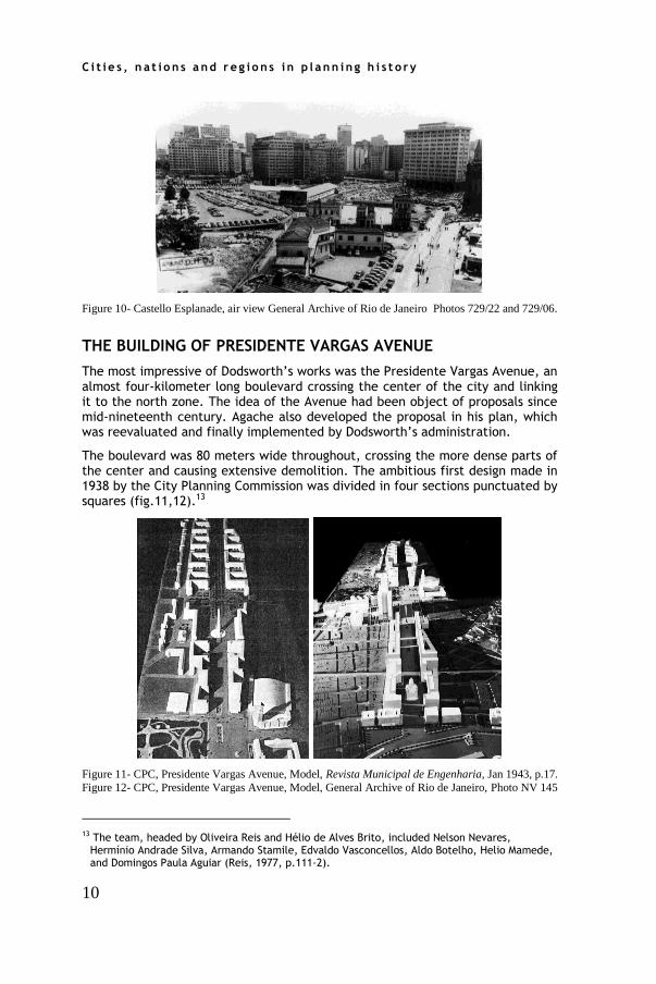
Figure 10- Castello Esplanade, air view General Archive of Rio de Janeiro Photos 729/22 and 729/06.
THE BUILDING OF PRESIDENTE VARGAS AVENUE
The most impressive of Dodsworth’s works was the Presidente Vargas Avenue, an almost four-kilometer long boulevard crossing the center of the city and linking it to the north zone. The idea of the Avenue had been object of proposals since mid-nineteenth century. Agache also developed the proposal in his plan, which was reevaluated and finally implemented by Dodsworth’s administration.
The boulevard was 80 meters wide throughout, crossing the more dense parts of the center and causing extensive demolition. The ambitious first design made in 1938 by the City Planning Commission was divided in four sections punctuated by squares (fig.11,12).13
Figure 11- CPC, Presidente Vargas Avenue, Model, Revista Municipal de Engenharia, Jan 1943, p.17.
Figure 12- CPC, Presidente Vargas Avenue, Model, General Archive of Rio de Janeiro, Photo NV 145
13 The team, headed by Oliveira Reis and Hélio de Alves Brito, included Nelson Nevares,
Hermínio Andrade Silva, Armando Stamile, Edvaldo Vasconcellos, Aldo Botelho, Helio Mamede, and Domingos Paula Aguiar (Reis, 1977, p.111-2).

1 5 t h I N TE RN A T I ON A L P LA N N I N G H I ST O RY S OC I ETY C ON F ER EN C E
11
The design of the first and second sections (from Bandeira Square to Onze Square) was credited to Hermínio de Andrade e Silva, who attempted to incorporate CIAM principles, designing a long line of interconnected blocks in redent and supported by pilotis with open spaces between them. The avenue partially existed, but it was sided with warehouses, factories and working class residences. These sections of the avenue were realized, but the buildings came much later and not following this pattern.14
Section three and four, in the dense center, was made by the whole team, under the direction of Hélio Britto. The new avenue replaced a straight line of blocks, which existed between São Pedro and General Câmara Streets (fig.13). The buildings were designed as walls facing the avenue, providing it with a strong directionality and carrying the eye to the focal points, Republica Square and the arrangement for the Candelária Church. The heights of the buildings were 24 floors (including the two floors of the galleries), totaling 75 meters. The buildings had to strictly follow the building codes approved for the Avenue in December 1940 (fig.14). The dimensions of galleries were similar to those stipulated for the Castello. These regulations led to the creation of a harmonious ensemble in which monumentality was a key characteristic.15
Figure 13- CPC, Demolitions for the new avenue, Revista Municipal de Engenharia, Nov, 1938, p.28.
Figure 14- CPC, Codes for the new avenue, Revista Municipal de Engenharia, Nov, 1941, p.325.
The municipality decided to begin the building of all sections of the Avenue simultaneously. The final plan was presented and quickly approved in December 1940.16 Construction officially began in April 1941, and was followed by the newspapers, which incessantly publicized the progress. Sections one and two (the modernist sections designed by Andrade e Silva), were soon completed, since they did not involve large expropriations and demolitions. These sections
14 Andrade Silva and Rosário advocated a new way of occupying urban land, replacing blocks with
new isolated towers and leaving open green areas. (Andrade e Silva, Rosário, 1942), p.12-20. 15 In the few official accounts of the avenue, after stressing its vital need, the reports shifted to
its grandiosity and then proceeded directly to dry and long explanations of technical details, such as stone-cutting and paving (Reis, 1994, Brito, 1944, p.3, Brito, 1945, p.54-69).
16 The project was approved by the decree 6897 from December 8, 1940. Before that, the decree 6747 of August 7 1940 established the expropriations. Sections of the avenue were dispossessed earlier by the decrees 6368 and 6368 in December 1938, and 6630 of November 29 1940.

C i t i e s , n a t i o n s a n d r e g i o n s i n p l a n n in g h i s t o r y
12
were inaugurated on November 10 1941, but neither the buildings nor the reorganization of the Onze Square with the obelisk and the bypass was ever realized. The third section (from Republica Square to Candelaria Church) and the fourth section (From the Church to the Shore), were inaugurated on November, 10 (the anniversary of the Estado Novo) of 1942 and 1943, respectively. All the works of the avenue completed in September 1944.
Sections three and four, cutting through the dense core of the city, were the most challenging to implement, since they involved large demolition of urban fabric, including historic religious buildings. Intimate squares and courtyards and the old Town Hall Square, disappeared. Among the many buildings demolished, were jewels of colonial religious architecture like São Pedro dos Clérigos and Bom Jesus. These demolitions provoked protests from shop owners, workers and intellectuals, but the municipality had the full support of Vargas for the enterprise. The numbers offer an idea of the magnitude of the intervention: of the 43 blocks that entirely disappeared, only 16 were replaced, of the 1225 buildings demolished (525 of them stood in the way of the avenue) only 179 new lots were made available. This great operation substantially transformed the cityscape and forced thousands of people to move (without a resettlement program) to the periphery of the city (Brito, 1944, p.111, Brito, 1945, p.63).
The funding for this venture was obtained through the same system of bonds, obrigações urbaníticas, used for Castello. Every bond was assigned to a new lot and many of them were bought by the federal bureaucracy.17 The central area around Rio Branco Avenue and Candelária Chuch attracted more investors. Despite Edison Passos’s affirmations that the project was feasible, the enterprise was not as successful as the Castello district. The selling of bonds did not occur as expected and the municipality was forced to take a loan from the Bank of Brazil in 1941, with Vargas’s timely intervention (Passos, 1941, p.221).
The new Presidente Vargas Avenue radically altered Rio’s cityscape. Aerial photos taken after the construction of the Avenue dramatically show the immense clear cutting through the center (fig.15). Some views are particularly disturbing, such as the one portraying the Candelária Church standing isolated and people wandering in the vastness of the avenue, without cars or surrounding buildings and the one showing the break of scale between the traditional two-story buildings facing the 80-meter wide avenue.
The focal point of the avenue was the setting for the Candelária Church. Like Agache before, the CPC realized the potential of creating a majestic space using the Candelária Church, a monumental classical church began in 1775, as a major element. The Church was liberated from the old building encroaching upon her walls. The avenue provided a dramatic reappraisal of the church, now standing freely in the great croissée. The new blocks and buildings were clearly designed to create a background for the church. While the height limit for the Avenue was twenty-two floors, the new buildings surrounding the church were limited to fourteen floors plus two receded floors, in order to prevent them from overwhelming the church.
17 This guarantee was introduced by the Law-Decree 2722/1940 and by the Municipal Decree n.
6896/1940. Reis, 1977, p.112.

1 5 t h I N TE RN A T I ON A L P LA N N I N G H I ST O RY S OC I ETY C ON F ER EN C E
13
Figure 15- Rio de Janeiro, Aerial view, General Archive of Rio de Janeiro, Photo R127/24. Figure 16- Perspective of the new avenue with the Candelária Church, General Archive of Rio de
Janeiro, R127/12 Revista Municipal de Engenharia, Nov, 1938, p.29.
Two renderings of the project clearly demonstrated the effects pursued by the designers (fig.16, 17). In the bird-eye view, the church appears encased by the nearby building blocks whose forms were shaped to fit the setting. In the other rendering, the church stands on a plateau flanked by groups of tall Brazilian palm trees, which were intentionally depicted to enhance its grandeur, making the rigorous classical lines of the façade expand into the site. The façades of nearby buildings were portrayed as blank and anonymous masses providing a theatrical setting. The entire space is governed by the rules of perspective and every plane or surface is flattened to enhance the effect of the Church. The Church façade was rediscovered as an independent object and an instrument of rhetoric. Even from the farthest point of the Avenue, the Church ends the perspective, but it was not only made to be admired as a fixed space, but to be appreciated from a moving vehicle. As Carl Schorske noted in the case of Vienna’s Ringstrasse, the Barroque perspective was updated by a more dynamic dimension of perceiving space by the rapid circular movement around it.
Figure 17- Perspective of the Candelária Church, Revista Municipal de Engenharia, Jul 1941, p.263..

C i t i e s , n a t i o n s a n d r e g i o n s i n p l a n n in g h i s t o r y
14
The ensemble reproduced entirely the sensations expressed by these renderings. The free standing Church reorganized the surroundings, making each neighboring building to form a background, providing theatricality and leading the eye to center on the church façade. They form repetitive and uniform patterns, almost emulating the openings, pediments, niches, and columns of the church.
The Avenue clearly expressed the intention of the regime to exalt its power, exposing a conflict between technical and rational discourse and monumental and symbolic aspirations. Although the authors constantly affirmed that the only aspect taken into account was a rational traffic system, it is impossible to dissociate this intervention from aesthetic intentions. The creation of scenery for the regime was the main objective. Any reasonable appreciation of the enterprise would reveal its inadequacies for Rio de Janeiro, but these aspects were forgotten in face of the possibilities of creating scenic spaces. A close look between the lines of the documentation available reveal these intentions. The model first exhibited in 1938, rapidly convinced Vargas, as Oliveira Reis later confessed: “Visiting the inauguration of the Exhibition, President Vargas was impressed by the model of the Avenue. Smiling, he glanced at Dodsworth and Passos and just exclaimed: ‘Let’s make it!’”18
Only an authoritarian government could make these reforms, since “..there were not politicians to disturb us and people knew that we were making the best for them”. 19 Critiques of the enterprise were silenced, protests of those expropriated were barely publicized, and few professionals risked expressing their opinions if not favorable to the venture. The personal involvement of Vargas was crucial for the silencing of the opposition.20 Critiques, however, started to emerge during 1945, when Vargas’s position was becoming fragile. When Dodsworth and Passos were leaving office and the political climate was being softened, Adalberto Szilard harshly criticized Vargas and Dodsworth as megalomaniacs for creating a monumental avenue to which there were not enough vehicles or buildings to fill it up, leaving exposed immense surfaces of concrete without any use except for heating up the city (Szilard, 1950, p.51). The disturbing vastness of the space, depicted in the first photos after the construction, did not disappear in a few years. Photos of the avenue, even in the 1950s and early 1960s showed it was used as a huge parking lot.
The President Vargas Avenue was inaugurated on September 7 1944, the holiday when Brazilian Independence is commemorated. The Avenue was completed in the short period of three years and became the most perfect setting for Vargas. Although most of the buildings were offices for private business and state institutes, the avenue had a more powerful ceremonial character than the Castello District. While the Castello, albeit holding ministerial headquarters, reconciled different interests and was more integrated into the city, the President Vargas Avenue, became the uttermost locus of power. Vargas attempted to symbolize the advent of a New Brazil and mark the Estado Novo as
18 José de Oliveira Reis, Interview in May 13 1992. Silva, 1993, p.48. 19 José de Oliveira Reis, Interview in July 7 1992. Silva, 1993, p.142. 20 As Oliveira Reis confessed: “The pressure on Dodsworth was tough, but with the support of the
President these obstacles were removed and the conclusion guaranteed.” (Reis, 1977, p.111).

1 5 t h I N TE RN A T I ON A L P LA N N I N G H I ST O RY S OC I ETY C ON F ER EN C E
15
a crucial milestone. His ambitions, however, were short-lived. In the following year he was forced to resign and the country returned to democracy.
CONCLUSIONS
In the modernization of Rio de Janeiro, the building codes had a crucial role, attempting to govern this weaving of urban elements, directing these dynamic forces and the desires of patrons, bureaucrats, and architects towards the creation of a modern city. Although buildings were designed by individual architects, the sense of the ‘whole’ was given by the CPC. In sum, the study of Castello Esplanade and the Presidente Vargas Avenue were unique opportunities to understand the complex making of a modern city.
The building of a modern city is a complex mosaic in which actors interacted, conflicts took place, and different interests were reconciled. The construction of modern Rio exposed multiple levels of mediation and negotiation among different world views, professions (architects, engineers, urbanists), and levels of power (federal and local).
Dodsworth’s reforms materialize the Vargas’ Estado Novo ideal for the city. The passage of Brazil into modernity was represented in architectural and urban forms. Deeming that social order could be shaped by spatial order, urban planners redesigned the center of Rio, laying new avenues and buildings and creating new urban settings to enforce values, such as discipline and efficiency. These urban planners clearly drew on Agache’s ideas, including the galleries, buildings patterns, and features of his plans. However, Agache’s ideas were reinterpreted in a particular way, in which only features of his plan were implemented. Blueprints for the city summarized the major aspirations of the elite, symbolizing the passage from a rural and archaic country to one that is modern and cosmopolitan.
REFERENCES
AGACHE, A. Cidade do Rio de Janeiro: Remodelação, extensão e embellezamento. Paris: Foyer Brésilien, 1930.
ALBUQUERQUE FILHO, L. A obra do urbanista Agache: sua atuação no Brasil. Revista do Club de Engenharia, 276, August, 1959, p.37-59.
ANDRADE E SILVA, Herminio Fusco Rosário, “Redivisão de quadras, condomínios e espaços livres” Revista Municipal de Engenharia, November, 1942, p.12-20.
Atividades e realizações da Secretaria Geral de Viação, Trabalhos e Obras Públicas, 1937-1939. Revista Municipal de Engenharia July, 1939, p.385.
BRITO, Hélio, Obras da Avenida Presidente Vargas. Revista Municipal de Engenharia, July/October, 1944, p.3-4,
BRITO, Hélio, Obras da Presidente Vargas Revista Municipal de Engenharia Abril, 1945.p.110-111.
Comissão do Plano da Cidade, Decreto n. 6022 de 8 Novembro de 1937. Revista Municipal de Engenharia, January, 1938, p.22-24.
Decreto 2722 de 30 de outubro de 1940. Revista Municipal de Engenharia, July, 1941), p.214.
C i t i e s , n a t i o n s a n d r e g i o n s i n p l a n n in g h i s t o r y
16
Decreto 3532 de 21 de agosto de 1941. Revista Municipal de Engenharia, November, 1941. 329-332
Decreto 6898 de 28 de Dezembro de 1940.in Revista Municipal de Engenharia November, 1941. p. 327-329.
GODOY, A. A urbs e seus problemas. Rio de Janeiro: Jornal do Commercio, 1943.
MACEDO, R. Henrique Dodsworth. Rio de Janeiro: DASP/Imprensa Nacional, 1955.
MELO, M.A. O Estado, o boom do século e a crise de habitação IN Cidade e História, Gomes, M.A. Fernandes, A. (Orgs). Salvador: UFBA, 1991.
Organização dos Serviços da Secretaria Geral de Viação, Trabalho e Obras Públicas. Revista Municipal de Engenharia, November, 1937, p.415-419.
PASSOS, Edison, Plano de Melhoramentos da Cidade do Rio de Janeiro” Revista Municipal de Engenharia July, 1941, p.217-222.
Plano de Melhoramentos da Cidade do Rio de Janeiro. Revista Municipal de Engenharia July, 1941, p.224-232.
Plano Diretor. Revista Municipal de Engenharia July, 1943. p.157-160.
Prefeitura do Distrito Federal, Prefeito H. Dodsworth, Relatório sobre as atividades da Prefeitura do Distrito Federal, julho de 1937 à julho de 1943. Rio de Janeiro: PDF, 1943.
REIDY, A.E. Urbanização da Esplanada de Castelo. Revista Municipal de Engenharia, September, 1938, p. 604-607.
REIS, J.O. O Rio e seus prefeitos. Rio de Janeiro: Prefeitura da Cidade, 1977.
REIS, José de Oliveira, 50 anos da Avenida Presidente Vargas. Revista Municipal de Engenharia, December, 1994.
Revista do Serviço Público, October,1939, p.11.
SILVA, L. O Rio de Janeiro e a reforma urbana da gestão de Dosdsworth (1937-1945). Anais do V Encontro Nacional da ANPUR. Belo Horizonte: ANPUR, 1993.
SZILARD, Adalberto. Urbanismo no Brasil. Rio de Janeiro: O Constructor, 1950.