
Rio de Janeiro - GEA Kring Rijnlandrijnland.gea-geologie.nl/sites/default/files/Rio de...
9
17‐10‐2012 1 Rob Hekkenberg Rio de Janeiro Een landschap van Morros en water De naamgeving Portugese schepen kwamen in 1502 langs Suger Loaf en dachten dat de Guanabara Bay de uitmonding was van een grote rivier. Guanabara Bay was first encountered by Portuguese explorers on January 1, 1502. According to some historians, the name given by the exploration team to the bay was originally Ria de Janeiro "January Sound", then a confusion took place between the word ria, which at the time was used to designate a bay or a sound, and rio "river". Anyway, the name of the bay was soon fixed as Rio de Janeiro A Portugese immigrant in 1895. Oude kaart van Guanabara Bay in de zestiende eeuw. Lang geleden, nog vóór Gondwana ontstond Lang geleden, nog vóór Gondwana ontstond Lang geleden, nog vóór Gondwana ontstond
Transcript of Rio de Janeiro - GEA Kring Rijnlandrijnland.gea-geologie.nl/sites/default/files/Rio de...
17‐10‐2012
1
Rob Hekkenberg
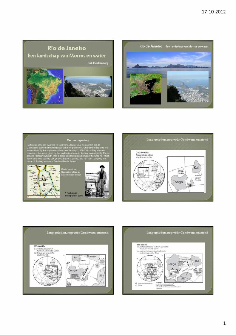
Rio de Janeiro Een landschap van Morros en water
De naamgeving
Portugese schepen kwamen in 1502 langs Suger Loaf en dachten dat de Guanabara Bay de uitmonding was van een grote rivier. Guanabara Bay was first encountered by Portuguese explorers on January 1, 1502. According to some historians, the name given by the exploration team to the bay was originally Ria de Janeiro "January Sound", then a confusion took place between the word ria, which at the time was used to designate a bay or a sound, and rio "river". Anyway, the name of the bay was soon fixed as Rio de Janeiro
A Portugese immigrant in 1895.
Oude kaart van Guanabara Bay in de zestiende eeuw.
Lang geleden, nog vóór Gondwana ontstond
Lang geleden, nog vóór Gondwana ontstond Lang geleden, nog vóór Gondwana ontstond
17‐10‐2012
2
Lang geleden, nog vóór Gondwana ontstond Verschillende cratonsvormen Gondwana
Position of Cameroon at the transition from the Congo Craton to the CAFB(modified after Kusky 2003)
Verschillende cratons vormen GondwanaGondwana is klaar
Gondwana valt uit elkaar
Fig. 1. Map of the South Atlantic salt province.
Gondwana valt uit elkaar
Figure 2 Main geomorphologic structures of the Brazilian margin.
Zout deposits
Africa
Vulcanic activitiesVulcanic activities
17‐10‐2012
3
Gondwanavalt uit elkaar
Gondwana valt uit elkaar
Figure 2 Main geomorphologic structures of the Brazilian margin.
Zout deposits
Africa
Vulcanic activitiesVulcanic activities
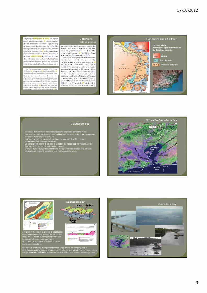
Guanabara Bay
De baai is het resultaat van een tektonische depressie gevormd in het Cenozoïcum (-66 Mj), tussen twee blokken van de storing: de Organ Mountains en een aantal grote kust-blokken.Het is de op een na grootste baai langs de kust van Brazilië, met een oppervlakte van ongeveer 380 km ².De gemiddelde diepte in de baai is 3 meter, 8,3 meter diep ter hoogte van de Rio-Niterói Bridge en 17 meter in het kanaalRio-Niterói Bridge en 17 meter in het kanaal. Vroeger, bij de instroom in de rivieren, mangroven was de afzetting, die was omringd door typische vegetatie voor het Atlantische woud.
Rio en de Guanabara Bay
Guanabara Bay
A graben is the result of a block of land being downthrown producing a valley with a distinct scarp on each side. Graben often occur side-by-side with horsts. Horst and grabenstructures are indicative of tensional forces and crustal stretching.
Graben are produced from parallel normal fault, where the hanging wall is downthrown and the footwall is upthrown. The faults typically dip toward the center of the graben from both sides. Horsts are parallel blocks that remain between graben;
Guanabara Bay

17‐10‐2012
4
Pau-nh-açuquã, Pot de beurre, Pao de assucar, Sugarloaf
Geologisch gezien is de berg een klein deel van een enorme granitische batholiet die aan weerszijden van de Baai van Guanabara langs de Braziliaanse kust dagzoomt. De batholietontstond 800 miljoen jaar geleden tijdens een fase van gebergtevorming. D i t t d it d b th li t d t d Ri dDoor erosie ontstonden uit de batholiet de rotsen rond Rio de Janeiro. De ronde vorm is kenmerkend voor graniet (een hard, homogeen en breukbestendig gesteente).Wanneer graniet in de beperkte ruimte van een intrusie uitkristalliseert bouwen zich zowel verticaal als horizontaal spanningen op, slechts in toom gehouden door het gewicht van het bovenliggende gesteente. Komt de intrusie vrij te liggen en valt die druk weg, waarbij gebogen lopende splijtvlakken ontstaan. Door erosie krijgt de rots een glad, gebogen oppervlak.
Wat is een Batholiet
BatholietEen batholiet is een lichaam stollingsgesteente, meestal diepte- of ganggesteente als graniet of granodioriet. Een batholiet is een uiteindelijk gestolde magmakamer. ges o e g e
De naam batholiet is afgeleid van de Griekse woorden bathos("diepte") en lithos ("gesteente").
Schematische weergave van intrusielichamen in een gebied waar vulkanisme plaatsvindt. A = batholiet (nog niet gestold: een magmakamer); B = dike; C = laccoliet; D = pegmatiet; E = sill; F = stratovulkaan. Processen in de afbeelding: 1 = jongere intrusie snijdt door een oudere heen; 2 = xenoliet of roof pendant in een magmakamer; 3 = contactmetamorfose; 4 = aardoppervlak wordt opgeheven als gevolg van het ontstaan van een laccoliet.
Pau-nh-açuquã, Pot de beurre, Pao de assucar, Sugar Loaf
De berg is één van zeven zogenaamde morros van graniet die vanuit de Atlantische Oceaan oprijzen in de buurt van Rio de Janeiro. (> 600Mj)
(A Morro is a rocky outcrop in the shallow waters of a harbor) Famous examplesare the San Felipe del MorroCastle, located in San Juan, Puerto Rico, Sugar Loaf in Rio de Janeiro, Brazil, MorroSolar in Lima, Peru and Morro Rock in California, USA
Sugar Loaf and Urca Hill
Pau-nh-açuquã, Pot de beurre, Pao de assucar, Sugarloaf
De berg is één van zeven zogenaamde morros van graniet die vanuit de Atlantische Oceaan oprijzen in de buurt van Rio de Janeiro. (> 600Mj)
(A Morro is a rocky outcrop in the shallow waters of a harbor) Famous examplesare the San Felipe del MorroCastle, located in San Juan, Puerto Rico, Sugar Loaf in Rio de Janeiro, Brazil, MorroSolar in Lima, Peru and Morro Rock in California, USA
Een aantal Morros
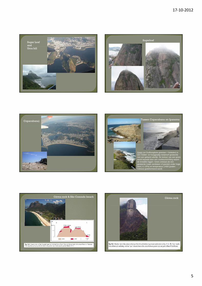
When you look west from the top of the rock (photo), you can see ArpoadorBeach, Ipanema, Leblon and, in the distance, Morro Dois Irmãos (Two Brothers Hill) and Pedra da Gávea (Gávea Rock) behind it
Corcovada (hunchback)
Corcovado, meaning "hunchback" in Portuguese,[1] is a mountain in centralRio de Janeiro, Brazil. The 710-metre (2,329 ft) granite peak is located in the Tijuca Forest, a national park. It is sometimes confused with nearby Sugarloafconfused with nearby Sugarloaf MountainCorcovado hill lies just west of the city center but is wholly within the city limits and visible from greatdistances. It is known worldwide forthe 38-meter (125 ft) statue of Jesus at the top of its peak, entitled Cristo Redentor or "Christ the Redeemer". (verlosser)
17‐10‐2012
5
Sugar LoafandUrca hill
Sugarloaf
Copacabana) Tussen Copacabana en Ipanema
Gneis (uit Oudhoogduits gneistan = fonkelen) is een middel- tot hooggradig metamorf gesteente met een geband uiterlijk. De textuur van een gneis wordt bepaald door een voorkeursrichting waarin de kristallen liggen. Gneis ontstaat als een gesteente (vaak zandsteen of graniet) onder hoge druk (>1 GPa) en temperatuur (>600 graden Celsius) gedeformeerd wordt.
Gávea rock & São Conrado beach Gávea rock
17‐10‐2012
6
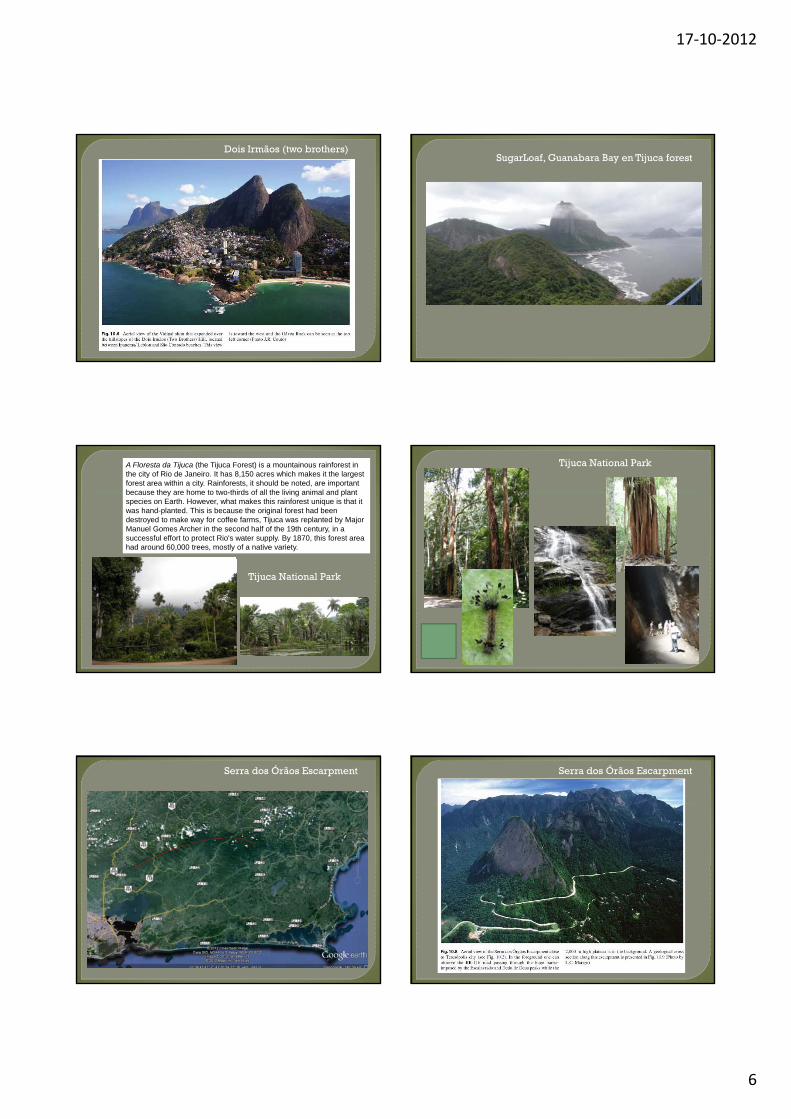
Dois Irmãos (two brothers)SugarLoaf, Guanabara Bay en Tijuca forest
A Floresta da Tijuca (the Tijuca Forest) is a mountainous rainforest in the city of Rio de Janeiro. It has 8,150 acres which makes it the largest forest area within a city. Rainforests, it should be noted, are important because they are home to two-thirds of all the living animal and plant species on Earth. However, what makes this rainforest unique is that it was hand-planted. This is because the original forest had been destroyed to make way for coffee farms, Tijuca was replanted by Major Manuel Gomes Archer in the second half of the 19th century, in a successful effort to protect Rio's water supply. By 1870, this forest area had around 60,000 trees, mostly of a native variety.
Tijuca National Park
Tijuca National Park
Serra dos Órãos Escarpment Serra dos Órãos Escarpment
17‐10‐2012
7
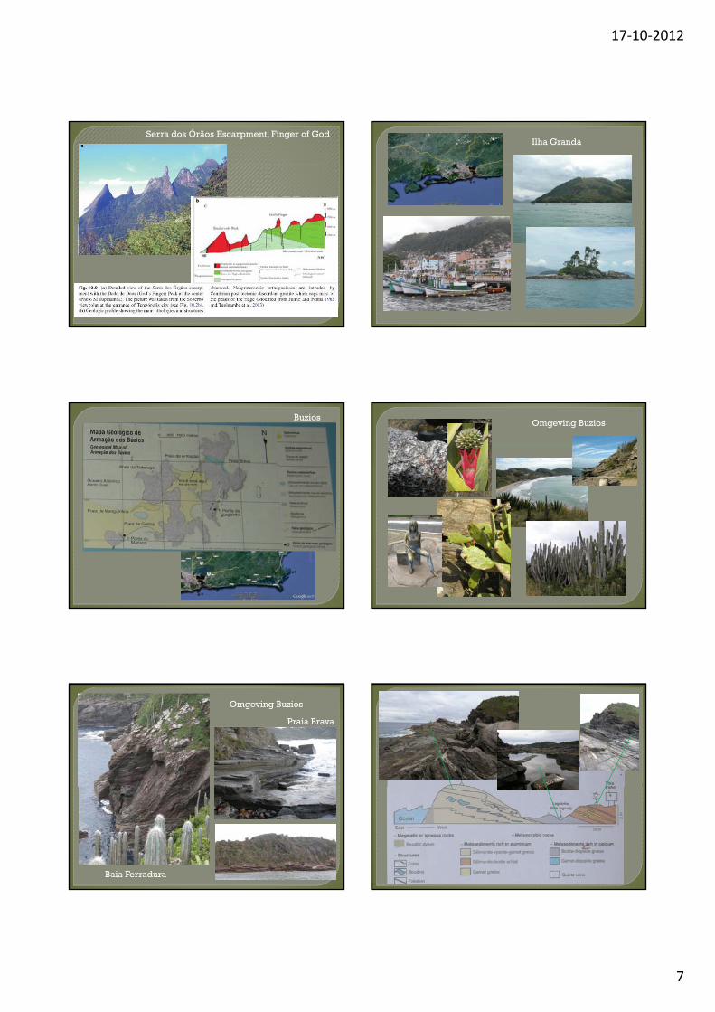
Serra dos Órãos Escarpment, Finger of God Ilha Granda
BuziosOmgeving Buzios
Omgeving Buzios
Praia Brava
Baia Ferradura

17‐10‐2012
8
Omgeving Buzios
Sillimaniet-biotiet schist
Granaat-biotiet schist
Diopsiet-biotiet gneis
Sillimaniet-kyaniet-granaat gneis
Omgeving Buzios
Kyaniet-granaat gneis vervormd
Omgeving Buzios
Basaltic Dykes
Veel vervuiling in de kust gebieden en de baai
De stad Rio de JaneiroDe Vavela’s
Referenties
- Geomorphological Landscapes of the World, Chapter 10, Rio de Janeirp: A metropolis between Granite –Gneiss Massifs, N.F.Fernandez, DOI 10.1007/978-90-481-3055-9_10, Springer, 2010
- LUIZ JOSE TOMAZELLI et al, LATE QUATERNARY GEOLOGICAL HISTORY OF RIO GRANGE DO SUL COASTAL PLAIN, SOUTHERN BRAZIL, Revista Brasileirade Geociências, 30(3):474-476, setembro de 2000
- IAN DAVISON, Geology and tectonics of the South Atlantic Brazilian salt basins, RIES, A. C., BUTLER, R. W. H. & GRAHAM, R. H. (eds) 2007. Deformation of the Continental Crust: The Legacy of Mike Coward. Geological Society, London, Special Publications 272, 345–359. 0305-8719/07/$15 © The Geological Society of LondonPublications, 272, 345 359. 0305 8719/07/$15 © The Geological Society of London 2007
- Emmanoel V. Silva-Filho et al, Groundwater chemical characterization of a Rio de Janeiro coastal aquifer, SE – Brazil, Journal of South American Earth Sciences 27 (2009) 100–108
- César Cainelli1 et al, Some remarks on the evolution of sedimentary basins along the eastern Brazilian continental margin, Episodes, Vol. 22, no. 3, 09-1999
- B. L. RENO, In situ monazite (U–Th)–Pb ages from the Southern Brası´lia Belt, Brazil: constraints on the high-temperature retrograde evolution of HP granulites, J. metamorphic Geol., 2012, 30, 81–112
- Wikipedia pages
17‐10‐2012
9


![Rio De Janeiro Brazil[1]](https://static.fdocuments.in/doc/165x107/54b9338c4a795919228b464d/rio-de-janeiro-brazil1.jpg)


