THE PROPOSED TOUWSRIVIER SOLAR ENERGY FACILITY Impact ...
245
THE PROPOSED TOUWSRIVIER SOLAR ENERGY FACILITY Final Environmental Impact Report DEA Ref: 12/12/20/1956 April 2011 Prepared for: CPV Power Plant No. 1 (Pty) Ltd 9th Floor, Convention Tower Heerengracht Foreshore Cape Town 8001 Prepared by: Environmental Evaluation Unit University of Cape Town Private Bag X3 Rondebosch Cape Town 7701
Transcript of THE PROPOSED TOUWSRIVIER SOLAR ENERGY FACILITY Impact ...
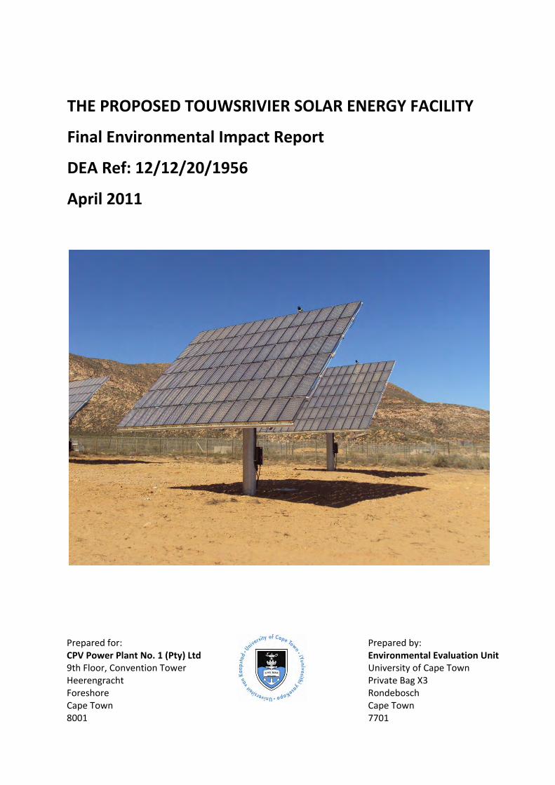
THE PROPOSED TOUWSRIVIER SOLAR ENERGY FACILITY
Final Environmental Impact Report
DEA Ref: 12/12/20/1956
April 2011
Prepared for: CPV Power Plant No. 1 (Pty) Ltd 9th Floor, Convention Tower Heerengracht Foreshore Cape Town 8001
Prepared by: Environmental Evaluation Unit University of Cape Town Private Bag X3 Rondebosch Cape Town 7701


i
PROJECT INFORMATION
PROJECT: Proposed Touwsrivier Solar Energy Facility
REPORT TITLE: Final Environmental Impact Report
EEU REPORT REFERENCE: 3/11/310
ENVIRONMENTAL AUTHORITY: The Department of Environmental Affairs (DEA)
DEA REFERENCE NO: 12/12/20/1956
APPLICANT: CPV Power Plant No. 1 (Pty) Ltd
ENVIRONMENTAL CONSULTANTS: Environmental Evaluation Unit, University of Cape Town
DATE: 20 April 2011

ii

iii
STATEMENT OF INDEPENDENCE
The Environmental Evaluation Unit (EEU) has been commissioned by CPV Power Plant No. 1 (Pty) Ltd
to undertake an Environmental Impact Assessment (EIA) in terms of the National Environmental
Management Act (107 of 1998) EIA Regulations (Government Notice (GN) R385, GN R386 and GN
R387 of April 2006). The EEU has complied with the general requirements for Environmental
Assessment Practitioners (EAPs) as set out below, from Chapter 3 (18):
An EAP appointed in terms of regulation 17(1) must –
(a) be independent;
(b) have expertise in conducting environmental impact assessments, including knowledge of the
Act, these Regulations and any guidelines that have relevance to the proposed activity;
(c) perform the work relating to the application in an objective manner, even if this results in
views and findings that are not favourable to the applicant;
(d) comply with the Act, these Regulations and all other applicable legislation;
(e) take into account, to the extent possible, the matters listed in regulation 8(b) when preparing
the application and any report relating to the application; and
(f) disclose to the applicant and the competent authority all material information in the
possession of the EAP that reasonably has or may have the potential of influencing –
(i) any decision to be taken with respect to the application by the competent authority in
terms of these Regulations; or
(ii) the objectivity of any report, plan or document to be prepared by the EAP in terms of
these Regulations for submission to the competent authority.

iv
v
EXECUTIVE SUMMARY
INTRODUCTION
CPV Power Plant No. 1 (Pty) Ltd is planning to develop the ‘Touwsrivier Solar Energy Facility’ on a site
approximately 12 km to the south‐west of Touwsrivier in the Breede Valley Municipality (BVM). The
Project would be a Concentrator Photovoltaic (CPV) system with a nominal generation capacity at
grid connection point of 50 MW for national distribution and would contribute to targets for
renewable energy generation in South Africa and the Province.
The site was selected on the basis of the outcomes of a preliminary assessment undertaken by the
Environmental Evaluation Unit (EEU) and associated specialists in 2009. This exercise iteratively
identified and evaluated 5 location alternatives for the Project and the site on Hartebeeskraal (1/36)
and Ratelbosch (4/149) was found most favourable in terms of the criteria which included type and
quality of vegetation, presence of rare plant species, soil type and depth, and the hydrology.
As the Project would be related to electricity generation where “(i) the electricity output is 20
megawatts or more; and (ii) the elements of the facility cover a combined area in excess of 1
hectare”, under the EIA Regulations, (GN R387) a Scoping and EIA are triggered. The EEU have been
commissioned to manage the Scoping and EIA environmental authorisation process.
Scoping was undertaken between July and October 2010 and concluded with an approval of the
Final Scoping Report from the Department of Environmental Affairs. The EIA commenced in October
2010 and followed the Plan of Study (PoS) which set out the methodology for this Phase. The EIA
has been an iterative process involving: geotechnical; agricultural; botanical; faunal; social; visual;
heritage; and palaeontological specialist studies and a Public Participation Process (PPP). The key
deliverables of the EIA phase is an Environmental Impact Report (EIR) and Environmental
Management Programme (EMP). The Draft EIR and EMP were made available for public comment to
allow the registered I&APs an opportunity to comment on the findings. I&APs were notified of the
review period and encouraged to provide written comment to the EEU. Comments are documented
in the IRR and recommendations have been updated in the body of the report where necessary.
ROLEPLAYERS
The Applicant
The applicant, also referred to as the developer, is CPV Power Plant No. 1 (Pty) Ltd, this entity having
been created for the purpose by Concentrix Solar, now Soitec, a leading provider of Concentrator
Photovoltaic (CPV) power plants in Germany.
The Environmental Assessment Practitioner
The Environmental Assessment Practitioner (EAP) is the EEU who would manage the application for
environmental authorisation on behalf of the applicant. The EEU is an independent, self‐funded,
research, consulting and training unit based at UCT which focuses on various aspects of
sustainability.
Specialists
Independent Specialists have been commissioned by the EEU to undertake studies specific to their
discipline: geotechnical, agricultural, botanical; faunal; social; visual; heritage; and palaeontological.
vi
Interested and Affected Parties
Interested and Affected Parties (I&APs) are any person, group or organisation interested in or
affected by the proposed activity; and any organ of state that may have jurisdiction over any aspect
of the activity. The environmental authorisation process aims to provide opportunities for everyone
to contribute to the process.
Commenting Authorities
Commenting authorities are those organisations or bodies whose focus or mandate is relevant to the
Project and associated activities. They are required to issue comments and recommendations to
ensure the process is robust and all aspects are considered.
Competent Authority
The competent authority is the decision‐making authority and in this case the listed activities require
a decision at the national level. The Department of Environmental Affairs (DEA) is therefore the
competent authority for this Project.
PROJECT DESCRIPTION
Technology
Soitec’s Concentrix™ CPV technology differs from conventional photovoltaic systems, in that the CPV
Modules use different solar cells and include lenses which focus light energy in a more concentrated
manner, hence harvesting more energy. The efficiency of the cells used provides benefits relating to
capacity per module, cost effectiveness, reduced spatial requirements and improved climate change
benefit, with a shorter energy payback period.
Infrastructure
The primary infrastructure units required for solar energy generation are called ‘CPV Systems’ or
‘trackers’. It is proposed that there would be up to 8,300 CPV Systems (6.5 kW per CPV System)
which facilitate a nominal generation capacity at grid connection point of 50 MW. The mechanical
structure of the CPV System is also called ‘tracker’ since the panel tracks the path of the sun. The
electricity is transmitted through underground cabling to the substation where it would be
transformed to a voltage that is compatible with the national grid. Ancillary infrastructure includes a
new substation to convert the electricity from 400 V to 132 kV for feeding into the electricity grid.
The CPV Systems would be connected to package substations by 400 V cabling. It is proposed that
the cables would be laid in trenches excavated to a depth of ±1 m and would follow internal access
roads where possible. From the package substations, underground medium voltage cabling would
connect to a central substation feeding into the 132 kV line passing a few kilometres south of the
site. The substation would be approximately 100 m x 100 m in size and the proposed 132 kV
transmission line would require a servitude width of about 52 m. A permanent facility for
operational and maintenance functions would require a footprint of approximately 350 m2 and
would include an office building housing also the power plant control centre, a workshop, a
warehouse, telecoms, security and ablutions. A parking area, a bus turning point and internal access
roads on the site would be required. Water would be abstracted from existing boreholes on‐site
mainly for the supply of on‐site ablution facilities and as cleaning water for the solar modules.

vii
Construction Phase
Construction is proposed for 24‐27 months from 2011 to 2013. A modular approach would be used
for the construction of power plant sections (fields of the trackers), which would be constructed in
continuous manner section by section and erected in 5 phases: (1) preparation and land survey, (2)
civil works, (3) cable laying, (4) mechanical and electrical system assembly, (5) commissioning and
optimization. A lay down and workshop/storage area (approximately 2,000 m2) would accommodate
the assembly of the tracker equipment during construction. The design of the transmission line
would depend on the route which is approved and construction would require clearance of the
servitude, a temporary access road where necessary, excavations, steelwork assembly, casting of
tower bases, erection of towers, line hardware installation on towers, stringing of lines and site
rehabilitation. Approximately 3,000 trucks in total (±4 trucks per day) would be required to transport
all the equipment to site which equates to 6 containers per week. It is intended to use local labour
forces where reasonably possible for construction. The estimated overall employment impact,
which includes highly skilled, semi‐skilled and unskilled labour, is in the range of 200 to 300 people.
Operational Phase
Operational activities mainly consist of module cleaning and regular maintenance of the tracking
units (drives, gears) and the electrical equipment (mainly inverters) and security patrolling. Cleaning
of the trackers is done on a rolling basis to assure a regular cleaning every 2 to 4 weeks (depending
on weather and site conditions). Maintenance is done on a rolling basis with six months intervals for
each CPV System. Surveillance and security staff are also required on a full time basis. With these
ongoing activities, a constant workload of staff is required. Operational traffic would comprise
approximately 1 truck with container, every 1 to 2 weeks for spare parts, as well as daily movements
from staff which would be either through a minibus service or private cars. It is intended to use local
labour forces where reasonably possible for the operation and maintenance phase of the facility. At
the present stage of the programme the overall employment impact, which includes skilled (10%),
semi‐skilled (20%) and unskilled personnel (70%), is in the range of 100 to 140 people. The training
concept would ensure that the most qualified and motivated staff from the construction phase shall
have the opportunity to form part of the permanent operation team. The infrastructure has a design
life of a minimum of 25 years, there would be no decommissioning during this lifetime, thereafter a
lease extension may be obtained, or the trackers would be retrofitted.
PROJECT ALTERNATIVES
Alternatives have been considered and assessed in order to identify the most effective way to meet
the need and purpose of the Project. The Scoping Phase included a comparative evaluation of five
Location Alternative, with the preferred site at Hartebeeskraal (1/36) and Ratelbosch (4/149)
forming the basis of the EIA. The ‘No Go’ option which involves maintaining the Status Quo has also
been assessed. In addition, the EIA process has comparatively assessed three different Grid
Connection Alternatives (two of which involve a proposed new 132 kV transmission line). In addition,
although not comparatively assessed, the Scoping and EIA process has considered Design and
Layout, Technology, and Input alternatives.
NEED AND DESIRABILITY
Need or ‘timing’ of the development can be seen in light of the present global trend towards
renewable energy which is largely based on initiatives to reduce the dependency on fossil fuels, the
viii
emission of greenhouse gases and their impacts on climate change. South Africa is actively seeking
to reduce impacts on climate change and has made commitments to international initiatives such as
the United Nations Framework Convention on Climate Change (1992), the Kyoto Protocol (1997), the
Johannesburg Declaration (2002), and the Copenhagen Accord (2009). This is also reflected in the
national and provincial policy framework. The promotion of renewable energy is part of this drive to
reduce emissions through diversification of electricity supply and energy security. The proposed
Project is a CPV Power Plant No. 1 (Pty) Ltd that converts energy from sunlight into electricity for
contribution to the national electricity grid. Solar energy is one of a number of freely available
sources for renewable power generation. However in South Africa, related technology is still
emerging and there are no existing large scale grid connected projects to date (Edkins et al, 2010).
This form of renewable energy technology often has the least impact on the surrounding
environment in terms of emissions, waste, and noise and the enabling policy environment highlights
the need for such development.
Desirability or ‘placing’ of the development has been assessed from a physical environmental
perspective through the pre‐scoping site selection process, and on a policy and planning level. The
Breede Valley Municipality’s Integrated Development Plan (IDP) (2007‐2012), Spatial Development
Framework (SDF)(2006) and Long Term Growth and Economic Development Strategy
(LTGEDS)(2008) highlight the high unemployment rate and associated social ills in the town of
Touwsrivier, as well as the need to diversify the economy to reduce the reliance on agriculture. It is
evident that the Project is desirable as it would contribute towards the vision for the area through
the generation of employment opportunities, and would also allow for rehabilitation of the site
which would lead to an overall improvement of the environmental quality in the area.
LEGAL, PLANNING AND POLICY CONTEXT
Environmental Management
Various acts, regulations, policies and planning documents provide the framework and context for
this Project and associated activities. In terms of environmental management, compliance with the
provisions in the following Acts would ensure that the environment is not adversely affected through
the development of the Project:
The Constitution (Act 108 of 1996);
National Environmental Management Act (107 of 1998) (NEMA);
Environment Conservation Act (73 of 1989) (ECA);
National Heritage Resources Act (25 of 1999) (NHRA);
National Environmental Management: Biodiversity Act (10 of 2004);
National Environmental Management: Protected Areas Act (57 of 2003);
National Water Act (No 36 of 1998);
National Environmental Management: Air Quality Act (39 of 2004);
National Environmental Management: Waste Act (59 of 2008);
Conservation of Agricultural Resources Act (43 of 1983) (CARA); and
National Veld and Forest Fire Act (101 of 1998);
Occupational Health and Safety Act (85 of 1993; and
Hazardous Chemical Substances Regulations (1995).
ix
Renewable Energy Generation
Other national legislation and policy which is relevant to the renewable energy context are as
follows:
National Energy Act (Act 34 of 2008);
White Paper on the Energy Policy of the Republic of South Africa (1998);
White Paper on Renewable Energy (2003);
NERSA Renewable Energy Feed‐In Tariff (REFIT) Guidelines (2009); and
Draft National Integrated Resource Plan (IRP) (2010).
Other provincial policy, plans and guidelines provide the context for the project and verify the
support for renewable energy and serve to guide the implementation thereof.
Developmental and spatial policy at the provincial and municipal level also provides the framework
within which this Project is being proposed. It is evident that the Project may contribute towards
addressing social and economic issued pertaining to the Touwsrivier area and in doing so, accord
with the vision for the area.
EIA PROCESS AND METHODOLOGY
The NEMA EIA Regulations require a two phased environmental authorisation process comprising
Scoping and an EIA.
Scoping Phase
The Scoping Phase was conducted between July and October 2010 and identified issues relevant to
the Project, potential environmental impacts of the activity; reasonable and feasible alternatives to
the Project; and proposed an approach to the EIA through a ‘Plan of Study’. During the Scoping
Phase, the Public Participation Process (PPP) commenced and included various methods of
notification calling for potential Interested and Affected Parties (I&APs) to register and /or provide
written comment and to invite attendance at a public meeting. A Background Information Document
(BID) was produced to summarise the project and the process and to provide a basis for any input.
Specialists in the fields of botany; fauna; visual; heritage; social and geotechnical, undertook Scoping
studies to identify impacts and issues relevant to their discipline and proposed the methods for
assessment in the EIA Phase. The process and findings were documented in the Draft Scoping Report
(DSR) which was made available to the I&APs for a 30 day review period allowing I&APs to comment
on the findings, the proposed methods and the process. The Final SR included responses to the
comments received within this period and was submitted to the DEA as the competent authority for
approval, which was then granted in October 2010.
EIA Phase
The EIA Phase commenced in October 2010 and the aim of this Phase was to address issues that
were raised during the scoping process; assess alternatives to the proposed activity in a comparative
manner; assess all identified impacts and determine the significance of each impact; and formulate
mitigation measures. Each specialist applied the methodology proposed in the Scoping Report and in
general, the assessment of significance took into account the following criteria: nature and status;
extent; duration; intensity; probability and effect on decision‐making. Further PPP activities included
a public meeting in Touwsrivier, meetings with selected commenting authorities, and telephonic or

x
email communications with other I&APS including neighbouring landowners. Grid studies revealed
that the only suitable option for connection of the 50 MW energy facility to the national grid in
terms of technical feasibility would be to the existing 132 kV Eskom transmission line a few
kilometres to the south of the site and these alternatives were included in the EIA. The findings of
the EIA were documented in the Draft EIR and accompanied by a Draft EMP (Ecosense, 2011). I&APs
were notified of the review period which was from 9 March 2011 to 8 April 2011 (18 April for state
authorities) and encouraged to provide written comment to the EEU. These comments are
documented in the Issues and Responses Report (IRR) and have been integrated into the report
where necessary. This Final EIR and EMP are for submission to DEA as the competent authority for
approval. Thereafter it may be accepted, rejected, referred for review or amendments may be
requested. Further to this, environmental authorisation is either granted or refused.
DESCRIPTION OF THE BASELINE ENVIRONMENT
Geographical and Administrative
The proposed site for the Project is located approximately 12 km south‐west of the town of
Touwsrivier and falls within the eastern portion of the Breede Valley Municipality (BVM), Western
Cape. The BVM is a Category B Municipality and essentially a rural municipality and is divided into 20
wards. The study area is located within Ward 1 (‘Touwsrivier’). The Project also falls within the
jurisdiction of the Cape Winelands District Municipality (CWDM).
Land Use
The total site footprint is approximately 215 ha and lies within portions of two different farms:
Hartebeeskraal (1/36) and Ratelbosch (4/149). The land required for Grid Connection Option 1a also
falls on Hartebeeskraal (1/36), whilst the land for Option 1b falls on land owned by Hans Heyvenrych
(Farm 740) and Casper Wolff (Farm RE/34). On the main site, the current land use is predominantly
agriculture and extensive grazing, with some peripheral vegetation of conservation value. The N1
National Road lies to the north of the site and the existing Trans‐Karoo main railway line borders the
site to the north. There is a Transnet substation on the site which provides electricity to the railway
line from the 66 kV Eskom transmission line passing across the site. The decommissioned alignment
of the historic 1930‐1989 Hex River Railway Pass traverses the site to the south, whilst the 1876
alignment is outside the site perimeter to the north.
Topography
The natural undisturbed parts of the site are characterised by moderately steep and stony vegetated
slopes, some of which become rocky in places. A minor seasonal ‘forked’ drainage line cuts across
the western half of the area, ‘flowing’ from south to north. Much of the drainage line is eroded due
to the close proximity of the ploughed area and channelisation in disturbed areas. In the east, the
study area lies along the lower pediment slopes of a larger rocky ridge. For the rest, the area is
relatively flat. The decommissioned former railway alignment has resulted in a raised stone
embankment all along the southern part of the study area.
Geology and Soils
The site is mapped as being underlain by bedrock of the Tra‐Tra, Hex River, Voorstehoek and Gamka
Formations of the Ceres Sub‐Group, Bokkeveld Group, and Cape Supergroup. The Tra‐Tra comprises
micaceous sandy shale and siltstone with alternating beds of siltstone and minor sandstone. It

xi
occurs over the southern portion of the site. Moving northwards, the Hex River Formation cuts
across the site in a narrow band in an east‐west direction. It typically comprises a light grey
feldspathic sandstone with subordinate thin beds of siltstone, gritstone and conglomerate. Its harder
and more resistant nature is responsible for the small ridge that crosses the site in this area. Most of
the site is underlain by the Voorstehoek Formation which typically comprises dark grey shale,
mudstone and siltstone with thin sandstone beds. It is less resistant and more easily weathered,
resulting in flatter, lower lying topography and the formation of some thin residual soils. It is
consequently the predominant area used for agriculture on the site. Further north, the Gamka
Formation traverses the site from west to east. It comprises dark grey sandstone and siltstone with
minor shale and conglomerate. It is relatively resistant to weathering and is responsible for the
ridge line immediately to the north of the central railway line currently in use. Paralleling the Gamka
Formation to the north is a relatively narrow band of outcrop of the Gydo Formation. This typically
comprises black to dark grey shale, siltstone and thin sandstone.
Water Resources
A single main drainage line with lesser tributaries cuts across the site from south‐west to north‐east.
Its catchment area beyond the site perimeter to the south‐west is significantly large. Drainage across
the site is restricted by culverts beneath the current and two historic railway lines, 1930‐1989 (to the
south) and 1876 (to the north). There are two large dams on the site connected by a drain and four
other smaller dams; with a further three very small dams or retention ponds sited where culverts
beneath the southernmost old railway line discharge onto the site. All natural water flows across the
site are ephemeral, the run‐off coefficient of the area is high which, coupled with the large
catchment areas, leads to large scale flash flooding at times. There is little evidence to suggest that
any of the dams have over‐topped in recent times however. Most, but not all of the drainage
channels on the site have been re‐aligned and straightened by digging trenches.
There are a number of boreholes on site, reputed to be of similar depth at approximately 100 m and
with similar yields of the order of 6,000 l/hour. The permanent water table is expected to be
relatively deep and to reside in the bedrock. Water quality is reputed to be variable but the borehole
to the south of the site appears to yield good quality water which is slightly saline to the taste.
Climate
The study area is located in the Western Cape and has a Mediterranean Climate, receiving more of
its rainfall during winter. However, the study area is located near the western edge of the Great
Karoo which is typically arid. The mean annual precipitation for the area is between 150 ‐ 470 mm,
with an average of 300 mm, which peaks in late winter (July to August) (Mucina and Rutherford,
2006). The area is subject to seasonal drought, but the most influential climatic factor is
temperature. The mean daily maximum is 27.4°C. Frequent high daily temperatures with relatively
low rainfall on aridified soil result in extreme evaporative potential, 2,014 mm and with a mean
rainfall of only 300 mm.
Agricultural Potential
The cultivation of the lands on the site and in the wider Touwsrivier area has proved to be
unproductive in the past as was the situation under dry‐land cultivation. Unwise land management
has led to the severe disturbance of the drainages, effectively turning them into desiccated donga
systems with the severe aridification of the soils adjacent to the drainages. This aridification is
extended throughout the lands due to unsuccessful dry‐land cultivation, soil compaction, soil
exposure and the loss of soil micro‐organisms. Organic material is lost to the soil which compacts
xii
and forms an impermeable soil crust that increases runoff and decreases infiltration. This all
contributes to minimal replenishment of the water table. The evaporative demand on the soil is
more than double the soil moisture supply and the mean of 300 mm rainfall is unable to adequately
replenish this moisture loss.
Botany
The plant communities in the affected area consist of a matrix of true Renosterveld on sandier soils
and Succulent Karoo communities on more clayey soils. Some typical fynbos elements occur on
south facing slopes and rocky outcrops within the Renosterveld. The majority of the affected area
has, however, been ploughed and the vegetation has been irreversibly changed to a very
impoverished community. Some alien annual grasses seem to be common during the winter and
spring rainy season. In some areas the old wheat fields have been planted with Oumansoutbos
(Atriplex nummularia). Some patches of natural vegetation do still occur adjacent to the ploughed
lands, of which the majority have been severely impacted upon by heavy grazing by domestic stock.
These areas are, however, still of significance to conservation as they have not lost their biodiversity.
The remnant patches of Succulent Karoo communities are of specific note in this respect. The only
other portions of the proposed development area that could be regarded as sensitive are the water
drainage lines. No rare plant species or communities were found here, but some may appear after
good rain.
In both transmission line options the vegetation consists of Succulent Karoo communities that have
been negatively impacted upon by heavy grazing pressure in the past, with an abundance of
indicators of disturbance such as Galenia africana attesting to the poor state of the vegetation. The
communities that occur along Option 1a are poor in species richness, with relative few succulent and
almost no geophyte species present. The communities that occur along Option 1b are in many
respects similar to those of Option 1a, except the northern portion that runs parallel along the
existing transmission line. Here the Succulent Karoo community consists of a similar species
combination as those noted as very sensitive within the solar farm site.
Fauna
In terms of potential fauna, most of the sensitive species are largely restricted to the natural
Renosterveld, Succulent Karoo and drainage line habitats. Of particular relevance are the Red Data
listed species, mammals afforded protected status in terms of Section 56(1) of the National
Environmental Management: Biodiversity Act (Act 10 of 2004), and those bird species which are
endemic or near endemic.
The site has a limited range of suitable habitats for amphibians. Only two of the twelve species on
the Touwsrivier checklist are considered likely to occur, one of which is a Red Data species with a
‘Data Deficient’ status. The presence or absence of reptiles is more difficult to determine as they
have a less predictable habitat, however the lack of wetland habitat areas is a key indicator. Of the
53 reptiles predicted to occur (based on the checklist), 31 are considered likely to occur (one was
confirmed), 10 were seen as possibilities and 11 were considered unlikely to occur on the site, none
of which are listed as Red Data species. A diversity of mammals have been predicted to occur on the
site, including Insectivores (shrews, moles), Chiroptera (bats), Primates (monkeys), Lagomorphs
(rabbits and hares), Rodents (rats and mice), Carnivores (cats, mongooses and otters) and Ungulates
(hoofed animals). Of the 70 species predicted to occur in the area, 11 were confirmed, 14 are
possibilities, 28 are considered likely to occur and 17 were considered unlikely to occur on the site.
The Red Data listed species include two moles, three bats, a rat and a weasel. Other species with

xiii
projected status include caracal, porcupine and common duiker. None of the listed Red Data
mammal species are likely to be negatively impacted by the preferred transmission line Option 1a.
The habitats available to birds on the study site may constitute only part of the ecological
requirements for many of the species as are they comparatively more mobile than other animals. Of
the 71 birds species predicted to occur in the general area (either permanently or partly), 11 are
confirmed and 60 are considered possibilities or likely to occur. Of these, only 2 are listed as Red
Data species: the blue crane (classed as Vulnerable); and the black harrier (classed as Near
Threatened). In addition, 8 endemic or near‐endemic (to the Sub‐region) bird species are predicted
to occur within the study area.
Social
The Touwsrivier community is characterised by extremely high unemployment levels (50%), very low
education and skills levels, and widespread poverty. The town offers very limited employment
opportunities and evictions of farm labourer families have swelled the town’s population. The 2007‐
2011 Breede Valley Municipality (BVM) Integrated Development Plan (IDP) recommends
development of the town and surrounds into a tourism destination as a key intervention strategy.
Specifically, the IDP recommends the creation of a steam train route between the town and De
Doorns and beyond, and harnessing the eco‐tourism opportunities associated with the Aquila Game
Reserve and Municipal (Touws River) Nature Reserve.
The 2007‐2011 BVM IDP also indicates that the spread of HIV/ AIDS and TB, as well as the spread of
a drug culture currently pose serious developmental challenges for the Municipality as a whole. The
fertile Hex River valley around De Doorns, which is located approximately 30 km west of the site, has
attracted significant labour‐related in‐migration over the past decade or so, leading to widely
publicised clashes between local and migrant communities in early 2010.
Visual
The surroundings are predominantly agricultural or natural karoo‐type veld in character ‐ an area
known, and revered, for its open expansiveness and rocky ‘koppies’. The scenic quality of the area
has, however, been compromised by railway cuttings and pylons, as well as by Eskom power lines,
an existing electrical substation and various borrow pits and spoil heaps.
The proposed site is highly visible from the N1 National Road and the railway line, which carries
passengers between major centres. The importance of these two transport routes at the regional
and national scale means that they could be considered as scenic corridors.
The site is visible from a farmstead on the other side of the N1, but not visible from any towns or
other settlements. The site is also not overlooked by any nature reserves or other protected
landscapes. The Touw Nature Reserve is about 8 km to the north‐east of the site. The site could
possibly be visible from the Bokkeriviere Nature Reserve on the Witberg Mountain, some 10 km to
the west, but distance would be a mitigating factor.
Heritage
In terms of archaeology, it is anticipated that there are likely to be traces of Middle and Early Stone
Age Material in the ploughed lands of the study area. The proposed activity does not involve any
rocky areas or rock shelters and therefore San rock paintings are not an issue. The historical
archaeology of the area relates mainly to railway history which has been the subject of a previous
study by the heritage specialist in collaboration with Ninham Shand (Pty Ltd) (1999) and includes the
following surviving heritage on site:

xiv
The decommissioned 1876 period railway alignment with embankments and some culverts;
The decommissioned 1930 – 1989 alignments with cuttings, culverts and ballast;
The abandoned 1946 tunnel east portal and deep railway cutting;
The abandoned 1946 South African Railways power station ruins; and
The existing recent main railway line and the Hex River railway tunnel east portal and tailings heap.
Palaeontology
The site is underlain by sediments of the Lower Bokkeveld Group (Cape Supergroup) of Devonian
age. These marine sandstones and mudrocks are assigned to four formations of which the Gamka
and Voorstehoek Formations are potentially highly fossiliferous, as demonstrated by the previous
history of fossil finds – notably marine invertebrates such as brachiopods, molluscs, trilobites and
echinoderms (e.g. starfish) ‐ within these rock units in the vicinity of the Hex River Valley.
A brief field assessment of the Bokkeveld Group sediments exposed within and on the margins of
the study area suggests that the proposed development is unlikely to have a significant impact on
local fossil heritage. Most of the Bokkeveld Group bedrocks are mantled by superficial deposits (e.g.
alluvium, soils) that are themselves of low palaeontological sensitivity. This is especially the case in
the low‐lying, flatter portions of the study area that would be most directly affected by the proposed
development. The fossil potential of a substantial proportion of the near‐surface Bokkeveld
mudrocks has been compromised by chemical weathering and tectonic cleavage. High‐volume
excavations into fresher mudrocks at depth are not envisaged for this development. Although field
scoping shows that invertebrate fossils are widely present, and locally abundant, within the
Voorstehoek Formation that underlies the central part of the study area, palaeontological material
here is generally sparse. Apart from ill‐defined traces (burrows etc.), fossils are apparently scarce
within the remaining Bokkeveld Group formations represented within the study area (i.e. Gamka,
Hexrivier and Tra‐Tra Formations).
Transport infrastructure
The rail infrastructure includes the Trans‐Karoo alignment running along the northern perimeter of
the site (and associated railway heritage). The nearest station is Kleinstraat Railway Station
approximately 1 km to the east, with Hugo Railway Station further approximately 5 km along the line
to the north‐east. Touwsrivier Railway Station is located within the town approximately 11 km to the
north‐east of the site.
There is limited road infrastructure within and surrounding the site. The N1 National Road connects
Cape Town with the interior and passes approximately 1 km north of the site. At present there is a
local access road which connects the site with the N1. A service road for the railway runs adjacent to
the existing rail alignment and there are a number of other local gravel roads.
xv
ASSESSMENT OF POTENTIAL ENVIRONMENTAL IMPACTS
The environmental impacts have been assessed by the respective specialists and the findings are
summarised below:
Botany
The proposed development may have two negative impacts, a threat to botanical biodiversity and
loss of rare and threatened species; and increased soil loss, through new access routes. This holds
true for all the development phases of the project (Construction, Operation and Decommissioning
phases). However, if the proposed mitigation measures are followed the development may have
positive impacts on the environment, as current ongoing operations continue to result in the
degradation of the area.
Fauna
The use of areas of untransformed natural vegetation for the proposed development will result in
the loss of habitat of certain sensitive faunal species. This is considered of high significance without
mitigation, but becomes low with mitigation. This impact is mitigated by restricting the
establishment of all infrastructure to the transformed parts of the site, i.e. old lands, roads, railway
line, and so forth. Option 1a is preferred for the transmission power line route in terms of habitat
loss.
The construction of the solar tracking infrastructure may further destabilize or transform the
sensitive drainages on the site, which represent sensitive fauna habitat and should thus be avoided.
Any vehicular access across any of the drainages should be constructed with minimum bank and
natural vegetation disturbance. A 15 m undisturbed natural buffer strip should be maintained on
both sides of the middle of each drainage line during all phases of the project. This impact is
assessed to be of high significance without mitigation and low with mitigation.
Habitat and population fragmentation will occur due to the security fence around the outer
perimeter of the area for populations of smaller and medium sized vertebrates. This may result in
the fragmentation of important areas of habitat for species such as hares, mongooses, porcupines,
tortoises and certain ground birds. In mitigation of this negative impact, a small gap of ±150 mm
should be provided at ground level, all along the security boundary fence around the affected area.
There is some potential for larger birds colliding with infrastructure when in flight. The affected area
is not a known “flight” path for larger birds, although bustards and blue cranes to occur in the area.
The problem generally relates to relatively “invisible” infrastructure like cables and power cables.
The security fence should be adequately marked and the entire length of the 132 kV transmission
line should be marked with bird “flappers” or diverters to make it visible.
The establishment of the proposed development may displace certain faunal species, temporarily or
permanently, as a result of the noise and physical disturbance that will be associated with the
construction phase of the development. Permanent displacement of any particular species should
not have any lasting negative impact on the survival of the population of that species, because of the
extensive availability of identical habitat immediately adjacent to the affected area.
There is a possibility that nocturnal insect‐eating bats may be attracted to the solar power
infrastructure at night by their prey insects that are attracted by security lights. The use of yellow
light rather than white light would mitigate this impact from medium to low since yellow light does
not attract flying insects.
xvi
The development may impact on Red Data listed vertebrates such as the Fynbos golden mole, the
Cape golden mole, white‐tailed rat and the striped weasel. This can be mitigated by restricting the
development to the already transformed areas and that no part of the untransformed Renosterveld
or Succulent Karoo should be disturbed in the interests of maintaining habitat and refuge for both
Red listed and other species. The drainage that lies across the study area must also be retained
undisturbed as part of the “natural” habitat and corridor area. None of the listed Red Data mammal
species are likely to be negatively impacted by the preferred transmission line Option 1a.
Of the 71 bird species predicted to occur on the study area, only 2 are listed as Red Data species
(Barnes, 2000). These are the blue crane (classed as vulnerable) and the black harrier (classed as
near threatened). There are also numerous other productive cultivated lands in the district which
can be used by these two Red Data species, so they are unlikely to be negatively impacted by the use
of the transformed part of the study area for the proposed development. The preferred power
transmission line Option 1a is unlikely to have any permanent negative impact on the avifauna,
other than the possibility of collisions. In addition to the Red Data bird species, the endemic or near
endemic bird species of the study area should also be considered important because these species
are endemic to the Subregion, which is thus entirely responsible for their global survival. The long
term protection of these natural parts of the study area will thus assist with the local conservation of
these endemics and near endemics.
Visual
Given the topography and nature of the landscape at the Touwsrivier site, the remoteness of the
area and the existing infrastructure on the site, it is anticipated that the solar energy facility would
have a medium to high visual impact before mitigation. It would be difficult to mitigate the
proposed solar facility, given its large footprint and its wide viewing angle as seen from the N1
National Road. The visual impacts can, however, be partly reduced by applying the visual mitigation
measures, and it is anticipated that the visual impact would be medium after mitigation.
The substation and operational buildings would have a medium visual impact before mitigation, and
medium to low impact after mitigation. The transmission lines in both options would have a medium
visual impact both before and after mitigation, as there is little opportunity for visual screening or
mitigation. The cumulative visual impacts are not considered to be significant, as there are no other
known planned energy facilities within the viewshed or adjacent to the area, nor proposals for
expansion of the solar energy facility.
Social
During construction, the key social issues associated with Project include:
Creation of employment and business opportunities, and the opportunity for skills development and on‐site training;
Influx of construction workers employed on the project;
Influx of job seekers;
Increased risk of stock theft, poaching and damage to farm infrastructure associated with construction workers; and
Loss of agricultural land associated with construction related activities.

xvii
During operation, the key social issues associated with the Project include:
Creation of employment and business opportunities. The operational phase would also create opportunities for skills development and training;
The establishment of infrastructure to generate renewable energy;
Potential impact on tourism;
Impact on farming activities; and
The visual impacts and associated impact on sense of place and landscapes.
The findings of the SIA indicate that none of the potential negative impacts associated with the
construction or operational phase would have a bearing on the decision. In addition all of the
potential negative impacts can be effectively mitigated if the recommended mitigation measures are
implemented. As a result the significance of all of the negative impacts with mitigation for decision‐
making was rated as low. However, the potential impacts associated with large solar energy facilities
on an areas sense of place and landscape cannot be ignored. There exist opportunities to enhance
the positive impacts, namely local employment and business opportunities. The proposed
development also represents an investment in clean, renewable energy infrastructure, which, given
the challenges created by climate change, represents a positive social benefit for society as a whole.
Heritage
There are three types of potential impacts:
Impact to cultural landscape (based on rural / wilderness qualities of the area);
Impact to pre‐colonial archaeology; and
Impact to historical industrial archaeology and built environment.
These negative impacts would all be of low significance if mitigation is applied and there is the
potential for a positive impact to the cultural landscape should the Project be decommissioned.
Mitigation relating to the cultural landscape would be based on those measure proposed in the VIA
for screening, whilst a policy of minimal intervention is required for the surviving rail heritage. A final
walk down of the proposed 132 kV route is required to assist with the siting of towers to avoid
sensitive areas.
Palaeontology
The impact of the proposed development on fossil heritage is likely to be local in extent, since fairly
rich fossil localities within the same geological units are already known elsewhere in the region. Loss
of recorded or unrecorded fossil heritage during the construction phase of the proposed
development is permanent, whereas the operational and decommissioning phases of the wind
energy facility would not involve further significant adverse or other impacts on palaeontological
heritage. The intensity of the impact on fossil is considered to be low in view of the relatively sparse
distribution of fossils within the study area as inferred from the field assessment study.
Furthermore, large‐volume excavations of potentially fossiliferous bedrock are not envisaged for this
development project. Since the Voorstehoek Formation that underlies the greater part of the
proposed development footprint is known to be generally fossiliferous, it is considered probable that
construction of the solar energy facility would have an impact on fossil heritage. In view of the
above, the overall impact significance of the proposed development on fossil heritage is considered
to be low. The expected impacts of the different grid connections proposed are more or less
identical, and the No‐Go option would not have a significant impact on local fossil heritage.
xviii
CONCLUSIONS AND RECOMMENDATIONS
Agricultural Potential
The former cultivated lands of the study area are no longer economically productive and their
productive potential was probably originally overestimated. Both the extremes of the climate and
the nature of the substrate make the further agricultural cultivation of the area unwise and difficult
to justify financially. Even rehabilitation under the expert guidance of the Department of Agriculture
was not successful. Water extraction for cultivation would have a negative impact on the general
area, and would result in the further aridification of the land.
It is therefore recommended that the former cultivated lands of the study area should not be used
for agricultural production and that the disturbed areas can be made available for some other type
of land use such as the Touwsrivier Solar Energy Facility.
Geology and Hydrology
In summary, based on the geotechnical information gathered, the site is considered to be suitable
for the proposed development. The geotechnical specialist has set out a number of development
considerations based on the existing geology within the study area. These would assist with the
design of the facility and the layout in particular. Although it has not formed part of the impact
assessment, opportunities have been identified to improve the overall quality of the environment
within the study area. These are summarised as follows:
Implement measures to stabilise the drainage system including channels, dams and buffers;
Detailed water sampling and testing is required to confirm suitability of borehole water for use during construction and operation;
Potential to source construction materials on or near the site; and
Design of the facility should take into account the geological conditions and recommendations in order to save time and money.
Botany
The proposed development site does not pose a threat to the environment, both in terms of
botanical biodiversity pattern (rare or threatened plant species) or important ecological processes.
If mitigation measures are followed the proposed development holds no potential negative
cumulative impacts on the local environment or Critical Biodiversity Areas in the region. The most
important mitigation actions required are to retain the proposed solar farm site to the non‐sensitive
areas, and to exclude the sensitive Succulent Karoo and drainage lines. For the transmission line
routes Option 1a is by far the least sensitive option as an access road is already available along the
full length of the proposed route. The crossings of the water drainage areas, including those of
transmission line Option 1a), should be upgraded to prevent soil loss.
Fauna
Most of the sensitive species are largely restricted to the natural Renosterveld, Succulent Karoo and
drainage line habitats. It thus follows that by excluding these natural habitats from the area to be
developed, these Red listed fauna species will remain unaffected by the development. This is the
primary mitigation of this study. Vlok (2011) agrees that the Succulent Karoo areas should be
excluded in terms of botanical sensitivity but does not recommend the particular protection of the

xix
Renosterveld areas. These, however, should also be excluded from development area in the
interests of sensitive fauna conservation.
In terms of the less sensitive (commoner) fauna, it is also necessary to consider their needs. For
example, the larger grey rhebok (Pelea capreolus) and steenbok (Raphicerus campestris) that were
observed on the old lands must eventually be excluded from the developed area, in a manner that is
safe for them i.e. fence design. Other fauna utilizing the transformed area will simply move away to
undisturbed patches or continue to use the area in between the solar generation units. Habitat
improvement should occur in the interests of this resident fauna (e.g. rodents, lizards, geckos,
tortoises, birds).
It can thus be concluded that no sensitive fauna, or fauna population, will be universally or locally
threatened by the proposed development, provided that the natural Renosterveld, Succulent Karoo
and drainage line habitats are excluded from the area to be developed and that the mitigatory
measures are effectively implemented. These include a soil control programme to stabilise and
protect the drainage areas, vegetation establishment where the drainages have been disturbed,
rehabilitation of the former cultivated lands area by sowing in a variety of karroid shrubs and
grasses, reduce wind erosion and improve small fauna habitat and restore natural soil health;
providing a small gap (±150 mm), at ground level, all along the security fence; ensuring that the
security fence and all power lines are adequately marked and maintain a protected and rehabilitated
buffer zone along the drainages for 15 m on both sides. It is recommended that the site and
transmission line route should be monitored during construction and at intervals (agreed by the
relevant parties) during the operational phase of the project to determine avian and other faunal
mortalities.
Visual
The visual assessment indicates that the potential visual impacts for the proposed solar energy
facility would be medium to high before mitigation, and medium after mitigation. Visual impacts for
associated infrastructure would be medium before mitigation, and medium to low after mitigation,
while the transmission lines would remain medium as there is little opportunity for visual mitigation.
Given the location and scale of the proposed solar energy facility, only minor mitigations can be put
forward, which could partly reduce the visual impact significance. It is doubtful if the potential visual
impacts alone would constitute a fatal flaw. However, the solar energy facility should be subject to
the visual mitigation measures in order to reduce the potential visual impacts at the Touwsrivier site.
Such measures include a Visual Setback Line, and site layout and design considerations such as
building design, screening, signage and lighting. The use of the existing spoil heaps on the site for
construction materials would be a visual benefit resulting from the project.
Cumulative visual impacts are not considered to be significant as no other energy facilities are
proposed within the surroundings, and no future expansion of the proposed Project is planned.
However, two options for a 132 kV transmission line are proposed, Option 1a being 5 km long in a
south‐east direction, and Option 1b 7 km long in an east direction following the existing 66 kV line
and rail line. In both cases the alignment is progressively distant from the N1, and located in a
relatively remote area.

xx
Social
The findings of the SIA undertaken for the proposed Project indicate that the development would
create employment and business opportunities for locals during both the construction and
operational phase of the project. The proposed development also represents an investment in clean,
renewable energy infrastructure, which, given the challenges created by climate change, represents
a positive social benefit for society as a whole. The potential visual impacts associated with the
facility would impact on the areas rural sense of place and landscape character. This impact would
be for the entire operational lifespan (approximately 25‐30 years) of the facility. However, these
impacts are not considered to represent a fatal flaw. It is therefore recommended that the facility as
proposed be supported, subject to the implementation of the recommended mitigation measures
and management actions contained in the report.
Heritage
Given that the study area has a long history of industrial use, in‐part being the site of the junction of
railway lines, and the various attempts to construct the Hexton Tunnel complex, reuse of the site for
industrial purposes is considered acceptable in terms of historic continuity but clashes with the
current wilderness/rural character of the site. The proposed activity would not impact negatively on
surviving historical railway infrastructure. With respect to mitigation, a policy of minimal
intervention is recommended with respect to the surviving historical railway infrastructure. In terms
of archaeology, the site is considered to be insensitive however a walk‐over would be required for
the transmission lines once a route has been approved.
Palaeontology
The overall significance of the proposed development on palaeontological heritage is low and
specialist palaeontological mitigation of this project ‐ such as monitoring during the construction
phase when palaeontological impacts are generally most likely ‐ is not necessary. However, should
substantial fossil remains be exposed during construction, notably dense concentrations of well‐
preserved shelly fossils such as “starfish beds”, these should be carefully recorded (e.g.
photographed, with GPS location) and safeguarded by the responsible Environmental Control Officer
(ECO), preferably in situ. Heritage Western Cape and / or a qualified palaeontologist should be
alerted as soon as possible so that any appropriate mitigation measures can be considered.
Impact Statement for the Touwsrivier Solar Energy Facility
The avoidance of negative environmental impacts, wherever possible, has been adopted as the
approach for this environmental assessment process, with mitigation measures as a secondary
reaction to those impacts which cannot be prevented. It has been assessed that the proposed
development does not pose a threat to the natural environment, both in terms of botanical
biodiversity (rare or threatened plant species) or important ecological processes. Residual negative
impacts which remain after mitigation are mostly of low significance apart from the visual impacts
assessed as medium or medium to low during all project phases.
The key benefit will be the employment, training and business opportunities generated in the
context of the Touwsrivier local economy, assessed as medium or high to medium significance. The
physical environment would also be enhanced, namely through the mitigation of existing soil erosion
along the drainage channels assessed as having a high positive impact. In terms of palaeontology,
xxi
the potentially low negative impact may well change to positive as findings may contribute to and
improved understanding of local fossil heritage. The Project is further supported by the current
policy context and contributes to climate change mitigation through the investment in clean,
renewable energy generation and this is assessed has being of medium significance.
There are potential cumulative impacts which would arise from the development, although they are
assessed as not significant or low negative significance. The No Go Option results in no change to the
status quo which may not necessarily be preferable for all disciplines such as the botanical, faunal
and hydrological disciplines which would benefit from the opportunity for rehabilitation and
stabilisation of the drainage line. Social benefits such as the employment, training and business
opportunities would not be realised. At a broader level, the No‐Go option would represent a lost
opportunity for South Africa to supplement its current energy needs with clean, renewable energy.
These negative socio‐economic impacts in the form of opportunity losses have been assessed as
having a medium significance.
Three grid connection alternatives were assessed: Option 1a involving a new 5 km transmission line
along the farm boundary Hartebeeskraal 1/36 connecting to Eskom’s 132 kV line to the south‐east;
Option 1b, a 7 km transmission line traversing two other farms (740 and RE/34) connecting to
Eskom’s 132 kV line to the east; and Option 2, a direct on‐site connection to the Eskom 66 kV line
with a reduced capacity. The environmental assessment has found Option 1a as the preferred
alternative as the route follows an area of poor species richness which already has an access road
along most of its length as well as a farm boundary fence. Option 1b is longer and affects more
properties. Unlike Option 2, Option 1a would allow the full potential of the 50 MW facility to be
reached.
On the basis of the information above, the EEU finds no reason or fatal flaw which should prevent
the Touwsrivier Solar Energy Facility from being granted environmental authorisation. With respect
to grid connection, Option 1a is motivated as the preferred alternative on environmental and project
feasibility grounds and has been assessed as having an overall environmental impact of low
significance. However, approval of Option 2 which would have a neutral environmental impact is
requested in addition to the preferred transmission line option in the event that access to the 132 kV
line is not technically feasible, as advised by Eskom. The grid connection and related capacity of the
project that would be developed as the Touwsrivier Solar Energy Facility will therefore ultimately be
decided by Eskom and the Department of Energy. The approval of two grid connections options has
been discussed and agreed to in principle by Department of Environmental Affairs.

xxii

Touwsrivier Solar Energy Facility xxiii Prepared by EEU, UCT CPV Power Plant No. 1 (Pty) Ltd April 2011
TABLE OF CONTENTS
ACRONYMS
GLOSSARY OF TERMS
1 INTRODUCTION ............................................................................................................................... 1
1.1 BACKGROUND TO THE PROJECT ............................................................................................. 1
1.2 SCOPING PHASE ...................................................................................................................... 2
1.3 ASSESSMENT PHASE ................................................................................................................ 2
1.4 PURPOSE OF THE EIR ............................................................................................................... 7
2 ROLEPLAYERS .................................................................................................................................. 9
2.1 INTRODUCTION ....................................................................................................................... 9
2.2 APPLICANT .............................................................................................................................. 9
2.3 ENVIRONMENTAL ASSESSMENT PRACTITIONER .................................................................... 9
2.4 INTERESTED AND AFFECTED PARTIES (I&APs) ...................................................................... 11
2.5 COMMENTING AUTHORITIES ................................................................................................ 11
2.6 COMPETENT AUTHORITY ...................................................................................................... 12
3 PROJECT DESCRIPTION .................................................................................................................. 13
3.1 OVERVIEW ............................................................................................................................. 13
3.2 CONCENTRATOR PHOTOVOLTAIC TRACKER TECHNOLOGY .................................................. 13
3.3 DESIGN ASSUMPTIONS ......................................................................................................... 14
3.4 CONSTRUCTION PHASE ......................................................................................................... 17
3.4.1 Construction activities .................................................................................................. 17
3.4.2 Installation of trackers .................................................................................................. 17
3.4.3 Construction of Transmission Line (Options 1a and 1b) ............................................... 18
3.4.4 Provision of services ...................................................................................................... 18
3.4.5 Construction traffic ....................................................................................................... 18
3.4.6 Construction labour requirements ............................................................................... 19
3.4.7 Working hours ............................................................................................................... 19
3.4.8 Construction Timeframe ............................................................................................... 19
3.5 OPERATIONAL PHASE ............................................................................................................ 19
3.5.1 Permanent infrastructure and operational activities ................................................... 19
3.5.2 Operational traffic ......................................................................................................... 20
3.5.3 Operational labour requirements ................................................................................. 20
3.5.4 Working hours ............................................................................................................... 21
3.5.5 Operational Timeframe ................................................................................................. 21
3.6 DECOMMISSIONING .............................................................................................................. 21
4 PROJECT ALTERNATIVES ............................................................................................................... 23
4.1 INTRODUCTION ..................................................................................................................... 23
Touwsrivier Solar Energy Facility xxiv Prepared by EEU, UCT CPV Power Plant No. 1 (Pty) Ltd April 2011
4.2 NO‐GO ALTERNATIVE ............................................................................................................ 23
4.3 SITE AND LOCATION ALTERNATIVES ..................................................................................... 24
4.3.1 The Preliminary Site Selection Process ......................................................................... 24
4.4 TECHNOLOGY ALTERNATIVES ............................................................................................... 30
4.5 SITE FOOTPRINT ALTERNATIVES ........................................................................................... 30
4.6 SITE LAYOUT ALTERNATIVES ................................................................................................. 31
4.7 DETAILED DESIGN ALTERNATIVES ......................................................................................... 31
4.8 GRID CONNECTION ALTERNATIVES....................................................................................... 32
4.9 INPUT .................................................................................................................................... 33
4.10 SUMMARY ............................................................................................................................. 33
5 NEED AND DESIRABILITY ............................................................................................................... 35
5.1 INTRODUCTION ..................................................................................................................... 35
5.2 NEED ...................................................................................................................................... 35
5.3 DESIRABILITY ......................................................................................................................... 38
6 LEGAL, PLANNING AND POLICY CONTEXT .................................................................................... 41
6.1 SUMMARY OF LEGAL, PLANNING AND POLICY FRAMEWORK .............................................. 41
6.2 ENVIRONMENTAL LEGAL AND REGULATORY FRAMEWORK................................................. 42
6.2.1 The Constitution, Act 108 of 1996 ................................................................................ 42
6.2.2 National Environmental Management Act (107 of 1998) (NEMA) ............................... 43
6.2.3 Environment Conservation Act (73 of 1989) (ECA) ....................................................... 46
6.2.4 National Heritage Resources Act (25 of 1999) (NHRA) ................................................. 46
6.2.5 National Environmental Management: Biodiversity Act (10 of 2004) .......................... 47
6.2.6 National Environmental Management: Protected Areas Act (57 of 2003) ................... 47
6.2.7 National Water Act (No 36 of 1998) ............................................................................. 47
6.2.8 National Environmental Management: Air Quality Act (39 of 2004)............................ 48
6.2.9 National Environmental Management: Waste Act (59 of 2008) .................................. 48
6.2.10 Conservation of Agricultural Resources Act (43 of 1983) (CARA) ................................. 48
6.2.11 National Veld and Forest Fire Act (101 of 1998) ........................................................... 49
6.2.12 Occupational Health and Safety Act (85 of 1993) ......................................................... 49
6.2.13 Hazardous Chemical Substances Regulations (1995) ................................................... 49
6.3 ENERGY LEGAL AND REGULATORY FRAMEWORK ................................................................ 50
6.3.1 National Energy Act (34 of 2008) .................................................................................. 50
6.3.2 White Paper on the Energy Policy of the Republic of South Africa (1998) ................... 50
6.3.3 White Paper on Renewable Energy (2003) ................................................................... 51
6.3.4 Renewable Energy Feed‐In Tariff (REFIT) ...................................................................... 52
6.3.5 Integrated Resources Plan (IRP) 2010 ........................................................................... 52
6.3.6 Climate Change Strategy and Action Plan for the Western Cape (2008)...................... 53
6.3.7 White Paper on Sustainable Energy for the Western Cape (2008) ............................... 54
6.3.8 Strategic Initiative to Introduce Commercial Land Based Wind Energy Development to the Western Cape (2006) .............................................................................................................. 55
6.4 DEVELOPMENTAL AND SPATIAL POLICY ............................................................................... 57

Touwsrivier Solar Energy Facility xxv Prepared by EEU, UCT CPV Power Plant No. 1 (Pty) Ltd April 2011
6.4.1 Western Cape Provincial Spatial Development Plan (2009) ......................................... 57
6.4.2 Breede Valley Municipality Integrated Development Plan (2007‐2012) ...................... 58
6.4.3 The BVM Long Term Growth and Economic Development Strategy (2008) ................ 59
6.4.4 The BVM “Broad‐brush” Spatial Development Framework (2006) .............................. 59
6.5 ENVIRONMENTAL ASSESSMENT GUIDELINES ....................................................................... 61
6.5.1 National ......................................................................................................................... 61
6.5.2 Provincial ....................................................................................................................... 61
7 EIA PROCESS AND METHODOLOGY .............................................................................................. 63
7.1 INTRODUCTION ..................................................................................................................... 63
7.2 SCOPING PHASE .................................................................................................................... 64
7.2.1 Public Participation ....................................................................................................... 64
7.2.2 Specialist Studies ........................................................................................................... 66
7.2.3 Draft Scoping Report ..................................................................................................... 66
7.3 EIA PHASE .............................................................................................................................. 66
7.3.1 Public Participation ....................................................................................................... 66
7.3.2 Methodology for Assessing Significance ....................................................................... 68
7.3.3 Specialist’s Detailed Methodologies ............................................................................. 70
8 DESCRIPTION OF THE BASELINE ENVIRONMENT .......................................................................... 79
8.1 INTRODUCTION ..................................................................................................................... 79
8.2 GEOGRAPHICAL AND ADMINISTRATIVE CONTEXT ............................................................... 79
8.3 LAND USE AND OWNERSHIP ................................................................................................. 79
8.4 PHYSICAL ENVIRONMENT ..................................................................................................... 80
8.4.1 Topography ................................................................................................................... 80
8.4.2 Geology ......................................................................................................................... 81
8.4.3 Hydrology and Drainage................................................................................................ 82
8.4.4 Geohydrology ................................................................................................................ 83
8.4.5 Ground Profile and Soils ................................................................................................ 83
8.4.6 Water Table ................................................................................................................... 84
8.4.7 Climate .......................................................................................................................... 84
8.5 AGRICULTURAL POTENTIAL ................................................................................................... 84
8.5.1 Land Use History ........................................................................................................... 84
8.5.2 Description of the Physical Environment and its Constraints ....................................... 86
8.5.3 The Potential for Productive Agricultural Development .............................................. 87
8.5.4 Cultivation ..................................................................................................................... 88
8.6 BOTANY ................................................................................................................................. 88
8.6.1 Regional Conservation Status ....................................................................................... 88
8.6.2 Existing Plant Communities on the Site ........................................................................ 88
8.6.3 Plant communities within the transmission line corridors ........................................... 90
8.7 FAUNA ................................................................................................................................... 92
8.7.1 Faunal Occurrence ........................................................................................................ 92
8.8 SOCIAL ................................................................................................................................... 94

Touwsrivier Solar Energy Facility xxvi Prepared by EEU, UCT CPV Power Plant No. 1 (Pty) Ltd April 2011
8.8.1 Breede Valley Municipality ........................................................................................... 94
8.8.2 Study area roads and rail line ....................................................................................... 95
8.8.3 Study Area Land Use and Settlement Patterns ............................................................. 95
8.8.4 Socio‐economic Context ............................................................................................... 98
8.8.5 Potentially Affected Land Uses ................................................................................... 102
8.9 VISUAL ................................................................................................................................. 105
8.10 HERITAGE ............................................................................................................................ 107
8.10.1 Palaeontology ............................................................................................................. 109
8.10.2 Archaeology ................................................................................................................ 109
8.10.3 Built Environment ....................................................................................................... 109
8.10.4 Findings ....................................................................................................................... 112
8.11 PALAEONTOLOGY ................................................................................................................ 114
8.12 TRANSPORT INFRASTRUCTURE ........................................................................................... 115
9 IMPACTS ON BOTANY ................................................................................................................. 117
9.1 BOTANICAL ISSUES .............................................................................................................. 117
9.1.1 Impacts on the Succulent Karoo communities ........................................................... 117
9.1.2 Impacts on the vegetation along water drainage lines............................................... 117
9.1.3 Impacts on the Renosterveld/Fynbos communities ................................................... 117
9.1.4 Restoration of cultivated lands ................................................................................... 117
10 IMPACTS ON FAUNA ............................................................................................................... 121
10.1 LOSS OF NATURAL HABITAT ................................................................................................ 121
10.1.1 Impact ......................................................................................................................... 121
10.1.2 Mitigation .................................................................................................................... 121
10.1.3 Destabilisation of the drainages during construction ................................................. 122
10.1.4 Impact ......................................................................................................................... 122
10.1.5 Mitigation .................................................................................................................... 122
10.2 HABITAT / POPULATION FRAGMENTATION ....................................................................... 123
10.2.1 Impact ......................................................................................................................... 123
10.2.2 Mitigation .................................................................................................................... 123
10.3 INCREASE IN BIRD COLLISIONS WITH INFRASTRUCTURE .................................................... 124
10.3.1 Impact ......................................................................................................................... 124
10.3.2 Mitigation .................................................................................................................... 124
10.4 BAT (CHIROPTERA) COLLISIONS WITH INFRASTRUCTURE .................................................. 125
10.4.1 Impact ......................................................................................................................... 125
10.4.2 Mitigation .................................................................................................................... 125
10.5 IMPACT ON RED DATA FAUNA SPECIES .............................................................................. 125
10.5.1 Impact on Mammals ................................................................................................... 125
10.5.2 Impact on Birds ........................................................................................................... 126
10.5.3 Mitigation .................................................................................................................... 127
10.6 DISPLACEMENT OF FAUNA DURING CONSTRUCTION ........................................................ 127
10.6.1 Impact ......................................................................................................................... 127

Touwsrivier Solar Energy Facility xxvii Prepared by EEU, UCT CPV Power Plant No. 1 (Pty) Ltd April 2011
10.6.2 Mitigation .................................................................................................................... 128
10.7 FAUNA IMPACT AUDIT ........................................................................................................ 128
10.8 ALERNATIVE DEVELOPMENT OPTIONS ............................................................................... 128
10.9 POTENTIAL CUMULATIVE IMPACTS .................................................................................... 129
10.9.1 Overgrazing of natural habitat adjacent to the study area ........................................ 129
10.9.2 Severe soil erosion downstream ................................................................................. 129
11 SOCIAL IMPACTS ..................................................................................................................... 133
11.1 POLICY AND PLANNING ISSUES ........................................................................................... 133
11.1.1 Energy policy ............................................................................................................... 133
11.1.2 Site related aspects ..................................................................................................... 133
11.1.3 Local level development ............................................................................................. 135
11.2 SOCIAL IMPACTS ASSOCIATED WITH THE CONSTRUCTION PHASE .................................... 135
11.2.1 Creation of local employment, training, and business opportunities ........................ 136
11.2.2 Impact of construction workers on local communities .............................................. 139
11.2.3 Influx of job seekers to Touwsrivier ............................................................................ 141
11.2.4 Increased risk to stock, crops, pasture, game and farming infrastructure ................. 142
11.2.5 Damage to farm land .................................................................................................. 144
11.3 SOCIAL IMPACTS ASSOCIATED WITH OPERATIONAL PHASE .............................................. 146
11.3.1 Creation of employment skills‐development and business opportunities ................. 146
11.3.2 Development of infrastructure for the generation of clean, renewable energy ........ 148
11.3.3 Potential impacts on tourism ...................................................................................... 150
11.3.4 Impact on farming activities ....................................................................................... 152
11.3.5 Visual impact and impact on sense of place and landscape ....................................... 153
11.4 POTENTIAL HEALTH IMPACTS ............................................................................................. 154
11.5 GRID CONNECTION ALTERNATIVES..................................................................................... 155
11.6 ASSESSMENT OF CUMULATIVE IMPACTS ........................................................................... 155
11.7 ASSESSMENT OF NO‐DEVELOPMENT OPTION .................................................................... 157
11.8 SOCIAL IMPACTS ASSOCIATED WITH DECOMISSIONING PHASE ........................................ 158
12 VISUAL IMPACTS ..................................................................................................................... 163
12.1 MITIGATION MEASURES ..................................................................................................... 165
12.1.1 Essential Mitigation Measures .................................................................................... 165
12.1.2 Construction Mitigation Measures ............................................................................. 165
12.1.3 Operational Mitigation Measures ............................................................................... 166
12.1.4 Recommendations for Monitoring ............................................................................. 166
13 HERITAGE IMPACTS ................................................................................................................. 171
13.1 KINDS OF IMPACTS THAT COULD TAKE PLACE.................................................................... 171
13.1.1 Residual impacts ......................................................................................................... 171
13.1.2 Cumulative impacts ..................................................................................................... 171
13.1.3 Assessment of alternatives ......................................................................................... 172
13.2 IMPACTS TO THE CULTURAL LANDSCAPE ........................................................................... 172
13.2.1 Nature of impact ......................................................................................................... 173

Touwsrivier Solar Energy Facility xxviii Prepared by EEU, UCT CPV Power Plant No. 1 (Pty) Ltd April 2011
13.2.2 Extent of impact .......................................................................................................... 173
13.2.3 Mitigation .................................................................................................................... 173
13.3 IMPACTS TO PRE‐COLONIAL ARCHAEOLOGY ...................................................................... 173
13.3.1 Nature of impact ......................................................................................................... 173
13.3.2 Extent of impacts ........................................................................................................ 173
13.3.3 Mitigation .................................................................................................................... 173
13.4 IMPACTS TO HISTORICAL INDUSTRIAL ARCHAEOLOGY ...................................................... 174
13.4.1 Nature of impact ......................................................................................................... 174
13.4.2 Extent of impact .......................................................................................................... 174
13.4.3 Mitigation .................................................................................................................... 174
14 PALAEONTOLOGICAL IMPACTS ............................................................................................... 179
14.1.1 Nature and status of impact ....................................................................................... 179
14.1.2 Extent of impact .......................................................................................................... 179
14.1.3 Duration of impact ...................................................................................................... 179
14.1.4 Intensity of impact ...................................................................................................... 179
14.1.5 Probability of impact ................................................................................................... 180
14.1.6 Effect on decision making ........................................................................................... 180
15 CONCLUSIONS AND RECOMMENDATIONS ............................................................................. 183
15.1 OVERVIEW ........................................................................................................................... 183
15.2 AGRICULTURE ...................................................................................................................... 189
15.3 GEOLOGY AND HYDROLOGY ............................................................................................... 189
15.3.1 Drainage Channels ...................................................................................................... 189
15.3.2 Boreholes .................................................................................................................... 189
15.3.3 Construction materials ................................................................................................ 190
15.3.4 Development Considerations ...................................................................................... 190
15.4 BOTANY ............................................................................................................................... 190
15.5 FAUNA ................................................................................................................................. 191
15.6 SOCIAL ................................................................................................................................. 192
15.7 VISUAL ................................................................................................................................. 192
15.8 HERITAGE ............................................................................................................................ 193
15.9 PALAEONTOLOGY ................................................................................................................ 193
15.10 IMPACT STATEMENT FOR THE TOUWSRIVIER SOLAR ENERGY FACILITY ........................ 194
16 REFERENCES ............................................................................................................................ 197
LIST OF FIGURES
FIGURE 1.1: TOUWSRIVIER SOLAR ENERGY FACILITY ‐ SITE ALTERNATIVES .............................................................................. 3
FIGURE 1.2: TOUWSRIVIER SOLAR ENERGY FACILITY ‐ STATUS QUO ...................................................................................... 4
FIGURE 1.3: TOUWSRIVIER SOLAR ENERGY FACILITY – PROPOSED SITE LAYOUT ....................................................................... 5
FIGURE 1.4: TOUWSRIVIER SOLAR ENERGY FACILITY – TRANSMISSION LINE ALTERNATIVES ........................................................ 6
FIGURE 3.1: IMAGE OF A CPV SYSTEM .......................................................................................................................... 13
FIGURE 3.2: PRINCIPLE OF FLATCON® CPV .................................................................................................................. 14
FIGURE 3.3: SCHEMATIC VIEW OF THE COMPONENTS OF A FLATCON® CPV PLANT .............................................................. 14

Touwsrivier Solar Energy Facility xxix Prepared by EEU, UCT CPV Power Plant No. 1 (Pty) Ltd April 2011
FIGURE 5.1: ANNUAL DIRECT AND DIFFUSE SOLAR RADIATION (DME, ESKOM, CSIR, 2001, CITED IN WHITE PAPER FOR RENEWABLE
ENERGY, 2003) ............................................................................................................................................... 37
FIGURE 7.1: THE SCOPING AND EIA PROCESS ................................................................................................................. 63
FIGURE 8.1: HABITATS AND HABITAT SENSITIVITY OF THE STUDY AREA (THE GREEN AREA REPRESENTS THE FORMER CULTIVATED LANDS)
..................................................................................................................................................................... 85
FIGURE 8.2: KLEINSTRAAT AND ADJACENT FARMS IN RELATION TO THE PROPOSED SITE .......................................................... 102
FIGURE 8.3: EXTRACT FROM 1: 250 000 GEOLOGY SHEET 3319 WORCESTER (COUNCIL FOR GEOSCIENCE, PRETORIA) SHOWING THE
APPROXIMATE LOCATION (YELLOW POLYGON) OF THE STUDY AREA C. 12 KM SOUTH‐WEST OF TOUWSRIVIER, WESTERN CAPE
PROVINCE. .................................................................................................................................................... 114
FIGURE 9.1: THE LEAST SENSITIVE AND RECOMMENDED DEVELOPMENT AREA. ..................................................................... 118
FIGURE 10.1: EVALUATION OF HABITAT SENSITIVITY WITHIN THE PROPOSED DEVELOPMENT AREA ......................................... 122
LIST OF TABLES
TABLE 2.1: DETAILS OF THE APPLICANT ............................................................................................................................ 9
TABLE 2.2: DETAILS OF THE ENVIRONMENTAL ASSESSMENT PRACTITIONER .......................................................................... 10
TABLE 2.3: INDEPENDENT SPECIALIST CONSULTANTS ........................................................................................................ 10
TABLE 2.4: COMMENTING AUTHORITIES RELEVANT TO THE TOUWSRIVIER SOLAR ENERGY FACILITY ........................................... 11
TABLE 2.5: DETAILS OF THE COMPETENT AUTHORITY ....................................................................................................... 12
TABLE 3.1: BREAKDOWN OF SKILLS REQUIRED DURING CONSTRUCTION ................................................................................ 19
TABLE 3.2: BREAKDOWN OF SKILLS REQUIRED DURING OPERATION ...................................................................................... 20
TABLE 4.1: COMPARATIVE EVALUATION OF ALTERNATIVE SITES ......................................................................................... 28
TABLE 4.2: TECHNICAL DESCRIPTION OF GRID CONNECTION OPTIONS ................................................................................. 32
TABLE 5.1: SUSTAINABILITY ENERGY GOALS .................................................................................................................... 38
TABLE 6.1: RELEVANT ENVIRONMENTAL LEGISLATION AND POLICY ..................................................................................... 41
TABLE 6.2: RELEVANT ENERGY LEGISLATION AND POLICY .................................................................................................. 42
TABLE 6.3: ACTIVITIES REQUIRING SCOPING AND EIA ....................................................................................................... 44
TABLE 6.4: ACTIVITIES REQUIRING BASIC ASSESSMENT ..................................................................................................... 44
TABLE 6.5: LIST OF REGIONAL CRITERIA FOR WIND FARMS .................................................................................................. 56
TABLE 7.1: RATING OF EXTENT .................................................................................................................................... 69
TABLE 7.2: RATING OF DURATION ................................................................................................................................ 69
TABLE 7.3: RATING OF INTENSITY ................................................................................................................................. 69
TABLE 7.4: RATING OF PROBABILITY ............................................................................................................................. 70
TABLE 7.5: EFFECT OF SIGNIFICANCE ON DECISION‐MAKING ............................................................................................. 70
TABLE 8.1: MAMMAL SPECIES LIKELY TO OCCUR WITHIN STUDY AREA .................................................................................. 93
TABLE 8.2: RED DATA LISTED SPECIES – MAMMALS .......................................................................................................... 93
TABLE 8.3: MAMMALS WITH PROTECTED STATUS IN TERMS OF NEMBA .............................................................................. 93
TABLE 8.4: ENDEMIC AND NEAR ENDEMIC BIRD SPECIES PREDICTED TO OCCUR (BARNES, 2000). .............................................. 94
TABLE 8.5: POPULATION FOR TOUWSRIVIER AND THE BVM .............................................................................................. 98
TABLE 8.6: EDUCATION LEVELS FOR THE STUDY AREA (POPULATION 20 AND OLDER) ............................................................... 99
TABLE 8.7: STUDY AREA EMPLOYMENT LEVELS (15 – 64 AGE GROUP) ................................................................................. 99
TABLE 8.8: STUDY AREA INCOME LEVELS (FOR HEAD OF HOUSEHOLD) ................................................................................ 100
TABLE 8.9: SECTORAL CONTRIBUTION TO EMPLOYMENT .................................................................................................. 100
TABLE 8.10: OVERVIEW OF PROPERTIES ADJACENT TO THE PROPOSED SITE ......................................................................... 104
TABLE 8.11: LANDSCAPE DESCRIPTION OF THE SITE ....................................................................................................... 105
TABLE 8.12: POTENTIAL VISIBILITY FROM SELECTED VIEW POINTS .................................................................................... 107
TABLE 9.1: SIGNIFICANCE OF BOTANICAL IMPACTS ........................................................................................................ 119
TABLE 9.2: SIGNIFICANCE OF BOTANICAL IMPACTS FOR THE GRID CONNECTION ALTERNATIVES ............................................. 120
TABLE 10.1: SIGNIFICANCE OF FAUNAL IMPACTS .......................................................................................................... 130
TABLE 11.1: ASSESSMENT OF LOCAL EMPLOYMENT, TRAINING AND BUSINESS OPPORTUNITIES ................................................ 138
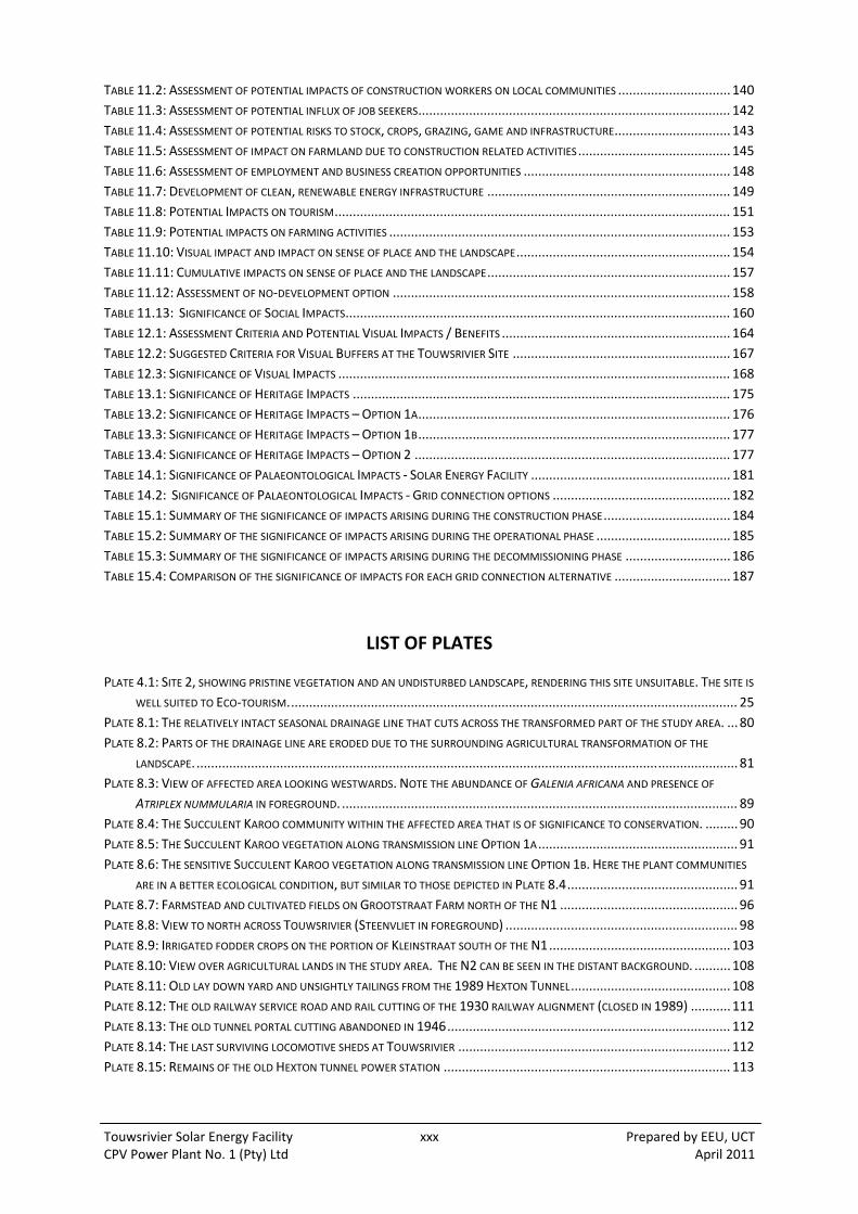
Touwsrivier Solar Energy Facility xxx Prepared by EEU, UCT CPV Power Plant No. 1 (Pty) Ltd April 2011
TABLE 11.2: ASSESSMENT OF POTENTIAL IMPACTS OF CONSTRUCTION WORKERS ON LOCAL COMMUNITIES ............................... 140
TABLE 11.3: ASSESSMENT OF POTENTIAL INFLUX OF JOB SEEKERS ...................................................................................... 142
TABLE 11.4: ASSESSMENT OF POTENTIAL RISKS TO STOCK, CROPS, GRAZING, GAME AND INFRASTRUCTURE ................................ 143
TABLE 11.5: ASSESSMENT OF IMPACT ON FARMLAND DUE TO CONSTRUCTION RELATED ACTIVITIES .......................................... 145
TABLE 11.6: ASSESSMENT OF EMPLOYMENT AND BUSINESS CREATION OPPORTUNITIES ......................................................... 148
TABLE 11.7: DEVELOPMENT OF CLEAN, RENEWABLE ENERGY INFRASTRUCTURE ................................................................... 149
TABLE 11.8: POTENTIAL IMPACTS ON TOURISM ............................................................................................................. 151
TABLE 11.9: POTENTIAL IMPACTS ON FARMING ACTIVITIES .............................................................................................. 153
TABLE 11.10: VISUAL IMPACT AND IMPACT ON SENSE OF PLACE AND THE LANDSCAPE ........................................................... 154
TABLE 11.11: CUMULATIVE IMPACTS ON SENSE OF PLACE AND THE LANDSCAPE ................................................................... 157
TABLE 11.12: ASSESSMENT OF NO‐DEVELOPMENT OPTION ............................................................................................. 158
TABLE 11.13: SIGNIFICANCE OF SOCIAL IMPACTS .......................................................................................................... 160
TABLE 12.1: ASSESSMENT CRITERIA AND POTENTIAL VISUAL IMPACTS / BENEFITS ............................................................... 164
TABLE 12.2: SUGGESTED CRITERIA FOR VISUAL BUFFERS AT THE TOUWSRIVIER SITE ............................................................ 167
TABLE 12.3: SIGNIFICANCE OF VISUAL IMPACTS ............................................................................................................ 168
TABLE 13.1: SIGNIFICANCE OF HERITAGE IMPACTS ........................................................................................................ 175
TABLE 13.2: SIGNIFICANCE OF HERITAGE IMPACTS – OPTION 1A ...................................................................................... 176
TABLE 13.3: SIGNIFICANCE OF HERITAGE IMPACTS – OPTION 1B ...................................................................................... 177
TABLE 13.4: SIGNIFICANCE OF HERITAGE IMPACTS – OPTION 2 ....................................................................................... 177
TABLE 14.1: SIGNIFICANCE OF PALAEONTOLOGICAL IMPACTS ‐ SOLAR ENERGY FACILITY ....................................................... 181
TABLE 14.2: SIGNIFICANCE OF PALAEONTOLOGICAL IMPACTS ‐ GRID CONNECTION OPTIONS ................................................. 182
TABLE 15.1: SUMMARY OF THE SIGNIFICANCE OF IMPACTS ARISING DURING THE CONSTRUCTION PHASE ................................... 184
TABLE 15.2: SUMMARY OF THE SIGNIFICANCE OF IMPACTS ARISING DURING THE OPERATIONAL PHASE ..................................... 185
TABLE 15.3: SUMMARY OF THE SIGNIFICANCE OF IMPACTS ARISING DURING THE DECOMMISSIONING PHASE ............................. 186
TABLE 15.4: COMPARISON OF THE SIGNIFICANCE OF IMPACTS FOR EACH GRID CONNECTION ALTERNATIVE ................................ 187
LIST OF PLATES
PLATE 4.1: SITE 2, SHOWING PRISTINE VEGETATION AND AN UNDISTURBED LANDSCAPE, RENDERING THIS SITE UNSUITABLE. THE SITE IS
WELL SUITED TO ECO‐TOURISM. ........................................................................................................................... 25
PLATE 8.1: THE RELATIVELY INTACT SEASONAL DRAINAGE LINE THAT CUTS ACROSS THE TRANSFORMED PART OF THE STUDY AREA. ... 80
PLATE 8.2: PARTS OF THE DRAINAGE LINE ARE ERODED DUE TO THE SURROUNDING AGRICULTURAL TRANSFORMATION OF THE
LANDSCAPE. ..................................................................................................................................................... 81
PLATE 8.3: VIEW OF AFFECTED AREA LOOKING WESTWARDS. NOTE THE ABUNDANCE OF GALENIA AFRICANA AND PRESENCE OF
ATRIPLEX NUMMULARIA IN FOREGROUND. ............................................................................................................. 89
PLATE 8.4: THE SUCCULENT KAROO COMMUNITY WITHIN THE AFFECTED AREA THAT IS OF SIGNIFICANCE TO CONSERVATION. ......... 90
PLATE 8.5: THE SUCCULENT KAROO VEGETATION ALONG TRANSMISSION LINE OPTION 1A ....................................................... 91
PLATE 8.6: THE SENSITIVE SUCCULENT KAROO VEGETATION ALONG TRANSMISSION LINE OPTION 1B. HERE THE PLANT COMMUNITIES
ARE IN A BETTER ECOLOGICAL CONDITION, BUT SIMILAR TO THOSE DEPICTED IN PLATE 8.4 ............................................... 91
PLATE 8.7: FARMSTEAD AND CULTIVATED FIELDS ON GROOTSTRAAT FARM NORTH OF THE N1 ................................................. 96
PLATE 8.8: VIEW TO NORTH ACROSS TOUWSRIVIER (STEENVLIET IN FOREGROUND) ................................................................ 98
PLATE 8.9: IRRIGATED FODDER CROPS ON THE PORTION OF KLEINSTRAAT SOUTH OF THE N1 .................................................. 103
PLATE 8.10: VIEW OVER AGRICULTURAL LANDS IN THE STUDY AREA. THE N2 CAN BE SEEN IN THE DISTANT BACKGROUND. .......... 108
PLATE 8.11: OLD LAY DOWN YARD AND UNSIGHTLY TAILINGS FROM THE 1989 HEXTON TUNNEL ............................................ 108
PLATE 8.12: THE OLD RAILWAY SERVICE ROAD AND RAIL CUTTING OF THE 1930 RAILWAY ALIGNMENT (CLOSED IN 1989) ........... 111
PLATE 8.13: THE OLD TUNNEL PORTAL CUTTING ABANDONED IN 1946 .............................................................................. 112
PLATE 8.14: THE LAST SURVIVING LOCOMOTIVE SHEDS AT TOUWSRIVIER ........................................................................... 112
PLATE 8.15: REMAINS OF THE OLD HEXTON TUNNEL POWER STATION ............................................................................... 113

Touwsrivier Solar Energy Facility xxxi Prepared by EEU, UCT CPV Power Plant No. 1 (Pty) Ltd April 2011
LIST OF APPENDICES
(See separate volume)
Appendix 1.1: Eskom Grid Connection Letter
Appendix 1.2: Department of Environmental Affairs Letter of Acceptance of the Final Scoping Report
Appendix 1.3: Constraints Map and Other Status Quo Mapping
Appendix 2.1: CV of EEU Staff:
Merle Sowman
Richard Hill
Sandra Rippon
Kirsten Scott
Appendix 2.2: Specialist CV:
Geotechnical and Hydrological – Mike van Wieringen and Associates
Botanical – Jan Vlok, Regalis Environmental Services
Faunal – Ken Coetzee, Conservation Management Services
Social – Tony Barbour and Schalk van der Merwe
Visual – Bernard Oberholzer and Quinton Lawson
Heritage – Tim Hart, UCT Archaeology Contracts Office
Palaeontology – John Almond, Natura Viva cc
Appendix 2.3: I&AP Database
Appendix 4.1: Preliminary Site Assessment
Appendix 6.1: Listed Activities
Appendix 7.1: Site Notice Board
Appendix 7.2: Newspaper Advertisement
Appendix 7.3: Written Notices
Appendix 7.4: Background Information Document (BID):
BID in English
BID in Afrikaans
Appendix 7.5: Minutes of Public Meetings
Appendix 7.6: Minutes of Stakeholder Meetings
Appendix 7.7: Issues and Response Report
Appendix 8.1: Geotechnical Report
Appendix 8.2: Agricultural Potential Report
Appendix 8.3: Botanical Impact Assessment
Appendix 8.4: Faunal Impact Assessment
Appendix 8.5: Social Impact Assessment
Appendix 8.6: Visual Impact Assessment
Appendix 8.7: Heritage Impact Assessment
Appendix 8.8: Palaeontological Impact Assessment

Touwsrivier Solar Energy Facility xxxii Prepared by EEU, UCT CPV Power Plant No. 1 (Pty) Ltd April 2011
ACRONYMS
ABBREVIATION TERM
BID Background Information Document
BVM Breede Valley Municipality
CARA Conservation of Agricultural Resources Act
CBA Critical Biodiversity Area
CDM Clean Development Mechanism
CPV Concentrator Photovoltaic
CV Curriculum Vitae
CWDM Cape Winelands District Municipality
DEA Department of Environmental Affairs (formerly DEAT)
DEAT Department of Environmental Affairs and Tourism
DEA&DP Department of Environmental Affairs and Development Planning (Western Cape)
DoE Department of Energy
DSR Draft Scoping Report
DTM Digital Terrain Model
DWAF Department of Water Affairs
EIA Environmental Impact Assessment
EAP Environmental Assessment Practitioner
ECA Environmental Conservation Act (No. 73 of 1989)
ECO Environmental Control Officer
ERC Energy Research Centre, University of Cape Town
GN Government Notice
ha Hectares
HGV Heavy Goods Vehicle
HWC Heritage Western Cape
IEM Integrated Environmental Management
I&AP Interested and Affected Party
IPP Independent Power Producer
IRR Issues and Response Report
NEMA National Environmental Management Act (No. 107 of 1998)
NERSA National Energy Regulator of South Africa
NHRA National Heritage Resources Act
PoS Plan of Study
PPP Public Participation Process
PV Photovoltaic
REFIT Renewable Energy Feed‐In Tariffs
SAHRA South African Heritage Resources Agency
SANBI South Africa National Biodiversity Institute
SSME Small, Micro and Medium Enterprise
UCT University of Cape Town
VIA Visual Impact Assessment
W/m2 Watts per square metre
Touwsrivier Solar Energy Facility xxxiii Prepared by EEU, UCT CPV Power Plant No. 1 (Pty) Ltd April 2011
GLOSSARY OF TERMS
TERM DEFINITION
Alien organisms Plants, animals and micro‐organisms which do not naturally occur in an area, and which have been deliberately or accidentally introduced by humans to ecosystems outside of their natural range.
Alternating Current (AC) A type of electrical current, the direction of which is reversed at regular intervals or cycles. Electricity transmission networks use AC because voltage can be controlled with relative ease.
Applicant The person or entity that intends to undertake a listed activity and is applying for permission.
Baseline Conditions that currently exist, also called ‘existing conditions’.
Biodiversity The variability amongst living organisms from all sources including terrestrial, marine, and other aquatic ecosystems and the ecological complexes of which they are part; this includes biodiversity within and between species and of ecosystems.
Bokkeveld Shales Sedimentary rock formed by layered silts and muds deposited by ancient Gondwanaland seas 400 million years ago. The shales are rich in fossils of early life forms.
Borehole Includes a well, excavation or any artificially constructed or improved underground cavity which can be used for the purpose of: intercepting, collecting or storing water in or removing water
from an aquifer; observing and collecting data and information on water in an
aquifer; or recharging an aquifer.
Climate Change Climate change means a change of climate which is attributed directly or indirectly to human activity that alters the composition of the global atmosphere and which is in addition to natural climate variability observed over comparable time periods.
Convertor A unit that converts a direct current (DC) voltage to another DC voltage.
Cumulative Impacts These are the impacts which, on their own, may not be significant. However, when added to many other similar impacts, the cumulative effect may be significant.
Direct Current (DC) A type of electricity transmission and distribution by which electricity flows in one direction through the conductor, usually associated with relatively low voltage and high current.
Distribution The electricity network infrastructure operating at nominal voltage of 132 kV or below.
Environment The environment has been defined as “The external circumstances, conditions and objects that affect the existence and development of an individual, organism or group”. These circumstances include biophysical, social, economic, historical, cultural and political aspects.
Environmental Assessment Practitioner
Person or company, independent of the applicant (developer), that manages the environmental assessment process of a proposed project on behalf of the applicant.
Touwsrivier Solar Energy Facility xxxiv Prepared by EEU, UCT CPV Power Plant No. 1 (Pty) Ltd April 2011
TERM DEFINITION
Integrated Environmental Management
A philosophy which prescribes a code of practice for ensuring that environmental considerations are fully integrated into all stages of the development process in order to achieve a sustainable balance between conservation and development.
Independent Power Producer Any undertaking by any person or entity, in which the government of South Africa does not hold a controlling ownership interest (direct or indirect), of new energy generation capacity at a generating facility following a determination made by the Minister in terms of section 34(1) of the Electricity Regulation Act (4 of 2006).
Interested and Affected Party Any person, group of persons or organisation interested in or affected by an activity contemplated in an application; or any organ of state that may have jurisdiction over any aspect of the activity.
Photovoltaic Module The smallest environmentally protected, essentially planar assembly of solar cells and ancillary parts, such as interconnections, terminals intended to generate DC power under unconcentrated sunlight.
Megawatt Hour 1000 kilowatts or 1 million watts; standard measure of electric power plant generating capacity.
CPV Module A concentrating photovoltaic (CPV) module consisting of space high efficiency solar cells and Fresnel lenses converting solar irradiation to electricity.
CPV System A tracking unit, CPV Modules and inverter, assembled with all necessary incidentals to produce electricity from solar irradiation.
CPV Power Plant Or CPV Plant, a quantity of CPV Systems connected together feeding electricity from solar power to the grid.
CPV Plant Auxiliaries Supplementary equipment required for correct operation of the CPV Power Plant.
Tracker table Assembled table of the tracking unit consisting of CPV Modules, aluminium profiles and supporting steel structure which tracks the sun.
Public Participation Process A process in which potential interested and affected parties are given an opportunity to comment on, or raise issues relevant to, specific matters.
Photovoltaic Cell The smallest semiconductor element within a PV module to perform the immediate conversion of light into electrical energy.
Renewable Energy Feed‐In Tariff
A tariff approved by NERSA for a renewable energy generator or cogeneration.
Sustainable Development Development that meets the needs of the present generation without compromising the ability of future generations to meet their own needs.
Touwsrivier Solar Energy Facility 1 Prepared by EEU, UCT CPV Power Plant No. 1 (Pty) Ltd April 2011
1 INTRODUCTION
1.1 BACKGROUND TO THE PROJECT
CPV Power Plant No. 1 (Pty) Ltd is proposing to develop a 50 MW Solar Energy Facility 12 km south‐
west of Touwsrivier in the Breede Valley Municipality (BVM). The facility would be a Concentrator
Photovoltaic (CPV) power plant and the primary infrastructure would include up to 8,300 CPV
Systems (trackers). Associated infrastructure includes a new substation, underground electrical
cabling, an operation and maintenance facility including offices, energy control centre, and a
warehouse, a parking area and bus turning point, internal access roads, and a water abstraction
point. There are three grid connection alternatives, two including 132 kV transmission line routes.
The site is 215 hectares (ha) in size and located on the farms Hartebeeskraal (1/36) and Ratelbosch
(4/149) to the south‐west of the N1 National Road between Touwsrivier and De Doorns. The existing
Trans‐Karoo main railway line borders the site to the north. The current land use is predominantly
extensive grazing with a history of cultivation, with some remnants of vegetation of conservation
value.
The site was selected on the basis of the outcomes of a preliminary assessment undertaken by the
Environmental Evaluation Unit (EEU) and associated specialists in 2009. The aim of this assessment
was to obtain an early indication of the viability of a range of identified sites and to facilitate
accurate planning of the Scoping and Environmental Impact Assessment (EIA) Phase to follow. The
potential sites were inspected by the environmental team with a focus on the type and quality of
vegetation, presence of rare plant species, soil type and depth, and the hydrology. The visual impact
of the trackers at each site was considered a key factor. Originally four sites in the vicinity of
Touwsrivier were assessed. Three of the four sites were located on the farm ‘Landdrost Drift 16’
which lies to the west of the town, on both sides of the N1, and has been declared a municipal
nature reserve, named the Touw Nature Reserve. The other site was commonage on the Touwsrivier
plain south‐east of Touwsrivier (see Figure 1.1 for location of the sites). Sites 1a and 1b were found
to represent the most favourable characteristics, however they were considered too small to be
viable on their own. An outcome of the assessment was a recommendation to seek alternative,
more suitable sites. The developer thus sought degraded farm land in the area, and with the
assistance of the environmental team identified the preferred site, a few kilometres to the south‐
west of the sites evaluated in the preliminary assessment. Figure 1.2 shows the status quo
environment of the preferred site and Figure 1.3 depicts the proposed site layout.
Once it was established that the current site was the most favourable, the EEU was commissioned by
CPV Power Plant No. 1 (Pty) Ltd as the Environmental Assessment Practitioner (EAP) to manage the
environmental authorisation process for the Project.
Through the specialist grid study and consultation with Eskom during the EIA Phase it emerged that
the grid connection to an existing 66 kV is less favourable in terms of electrical efficiency and
alternatives to connect to the 132 kV line to the south of the site should be included in the
assessment. Therefore two alternative grid connection options via a new 132 kV transmission line
were identified (Option 1a and 1b) as depicted on Figure 1.4. Eskom has however advised that
authorisation to connect to both 66 and 132 kV lines should be sought on the basis that the full
capacity on the 132 kV line may be allocated to other developer/s, rendering this option unavailable
(see Appendix 1.1).

Touwsrivier Solar Energy Facility 2 Prepared by EEU, UCT CPV Power Plant No. 1 (Pty) Ltd April 2011
1.2 SCOPING PHASE
Scoping was undertaken between July and October 2010 and involved a number of specialist studies:
botanical; faunal; visual; heritage; social and geotechnical, and the Public Participation Process (PPP).
The outcomes of this process were synthesised and presented in the Draft Scoping Report (DSR)
which was made available for public comment between August and September 2010. All written
comments received in the report, where included in the Issues and Responses Report (IRR). The Final
Scoping Report (FSR) was submitted to Department of Environmental Affairs (DEA) on 10 September
2010 and set out a Plan of Study (PoS) for the EIA Phase based on the key conclusions set out below.
With respect to the proposed activities, no fatal flaws were identified through the specialist scoping
exercises and the PPP. The key constraints were identified as the sensitive vegetation on parts of the
site which could largely be mitigated through avoidance. The visual impacts were an important
factor requiring detailed investigation into site layout and configuration of the trackers and other
infrastructure. The Project was identified as having potential socio‐economic benefits, which the
developer considers part of the overall concept. It was acknowledged that the developer is
committed to creating opportunities for the local population, skills development and training, and
involving local businesses to improve the local economy. The Touwsrivier area is suffering from
unemployment and associated deprivation and the identified benefits, together with the
contribution to renewable energy generation in the Province, were in support of the need and
desirability of the Project.
The EEU received a letter of acceptance on 11 October 2010 with a list of amendments and
additional information required. This is attached as Appendix 1.2.
1.3 ASSESSMENT PHASE
The purpose of an EIA is as follows:
Consider and assess alternatives which would most effectively meet the need and purpose of the Project and the goal of sustainable development;
To assess the identified impacts and to establish their significance using a specific framework (see Section 7.3.2 below);
To identify and recommend appropriate mitigation measures to reduce the significance of impacts; and
To carry out an effective and inclusive Public Participation Process.
During the EIA Phase, the specialists undertook their studies as set out in the FSR taking comments
from DEA into consideration. Each assessment has defined the significance of the potential impacts
and proposed mitigation measures where necessary and enhancement if possible. Further public
participation events were held including an Open Day on 25 November 2010 and meetings with key
I&APs, namely the commenting authorities. CNdV were commissioned to develop a set of
constraints maps to assist with the identification of a ‘developable area’ based on desktop
resources, mapping provided by the specialists and ground‐truthing. The site perimeter showing
constraints and exclusion areas is attached as Appendix 1.3 along with other status quo mapping
that has been generated. Figure 1.3 is the proposed site plan and forms the basis for the application
subject to detailed design and micro‐siting. Furthermore alternatives have been refined, in particular
the grid connection alternatives and these are reported on in Section 4. The process has been
iterative and inputs from the commenting authorities have been valuable in refining the assessment.

LegendProposed Site
( Site Alternatives
Roads
Client: CPV Power Plant No. 1 (Pty) LtdDate: April 2011
Environmental Evaluation UnitUniversity of Cape TownPrivate Bag X3Rondebosch 7700Cape TownTel: +27 21 650 2866Fax: +27 21 650 3971
Projection: GCS WGS 1984Datum: Geographic (WGS 1984)Data Source: Department of Surverys and Mapping Cape Town
0 1 20.5Km
¯Scale: 1:32,268
Project Location
Figure 1.1: Touwsrivier Solar Energy Facility - Site Alternatives
Site 4
Site 1b
Site 1a
Site 2
Site 3
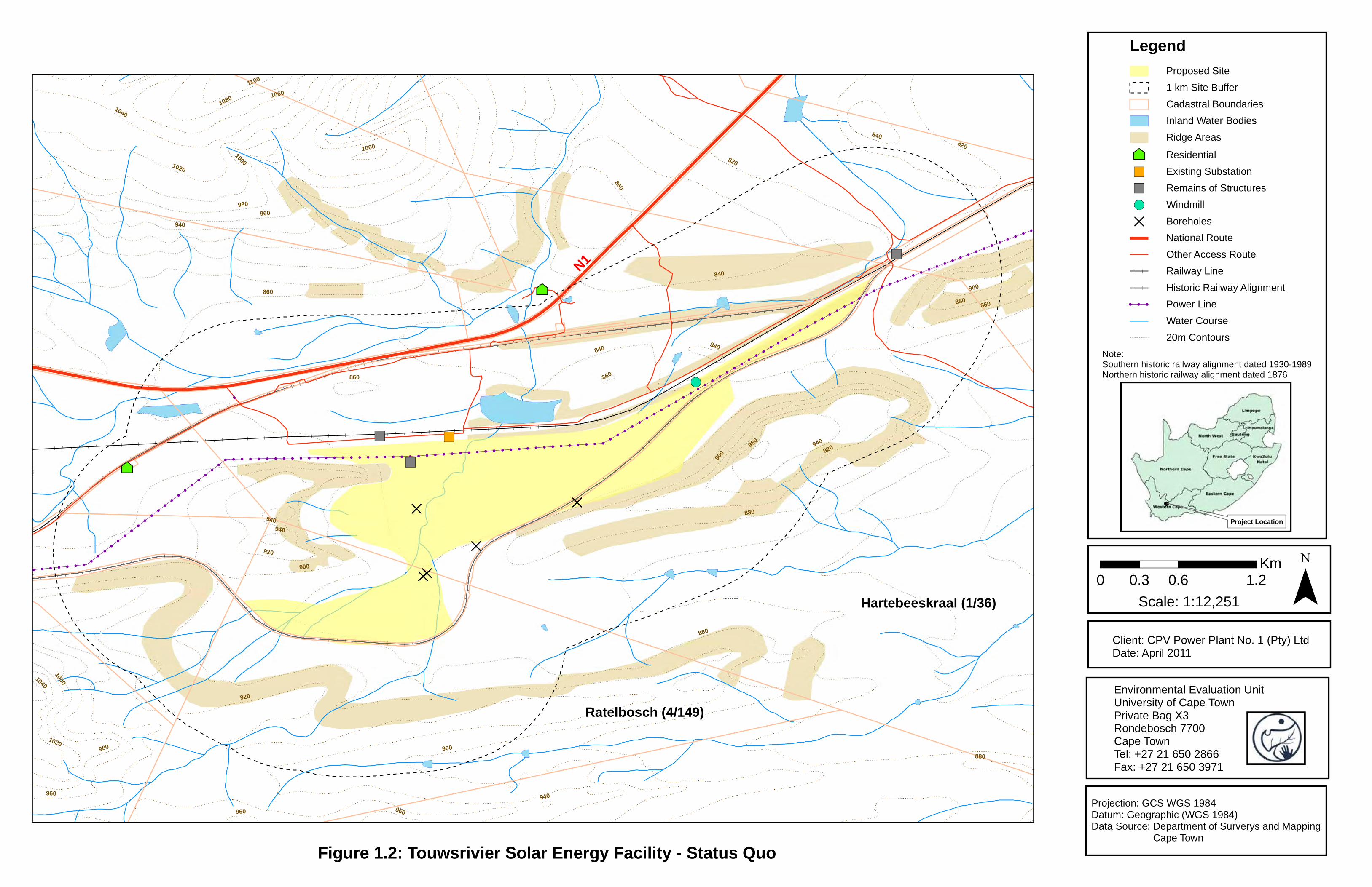
!
!
!
!
!
!
!
!
!
!
!
!
!
!
!
!
!
!
!
!
!
!
!
!
!
!
!
!
!
!
!
!
!
!
!
!
!
!
!
!
!
!
!
!
!
!
!
!
!
!
!
!
!
!
!
!
!
!
!
!
!
!
!
!
!
!
!
!
!
!
!
!
!
!
!
!
!
!
!
!
!
!
!
!
!
!
!
!
!
!
!
!
!
!
!
!
!
!
!
!
!
!
!
!
!
!
!
!
!
!
!
!
!
!
!
!
!
!
!
!
!
!
!
!
!
!
!
!
!
!
!
!
!
!
!
!
!
!
!
!
!
!
!
!
!
!
!
!
!
!
!
!
!
!
!
!
!
!
!
!
!
!
!
!
!
!
!
!
!
!
!
!
!
!
!
!
!
!
!
!
!
!
!
!
!
!
!
!
!
!
!
!
!
!
!
!
!
!
!
! ! ! ! ! ! ! ! ! ! ! ! ! ! ! ! ! ! ! ! ! ! ! ! ! ! ! ! ! ! ! ! ! ! ! ! ! ! ! ! ! ! ! ! ! ! ! ! ! ! ! ! ! ! ! ! ! ! ! ! ! ! ! ! ! ! ! ! ! ! ! ! ! ! ! ! ! ! ! ! ! ! ! ! ! ! ! ! ! ! ! ! ! ! ! ! ! ! ! !!
!!
!!
!!
!!
!!
!!
!!
!!
!!
!!
!!
!!
!!
!!
!!
!!
!!
!!
!!
!!
!!
!!
!!
!!
!!
!!
!!
!!
!!
!!
!!
!!
!!
!!
!!
!!
!
!
!
!
!
!
!
!
!
!
!
!
!
!
!
!
!
!
!
!
!
!
!
!
!
!
!
!
!
!
!
!
!
!
!
!
!
!
!
!
!
!
!
!
!
!
!
!
!
!
!
!
!
!
!
!
!
!
!
!
!
!
!
!
!
!
!
!
!
!
!
!
!
!
!
!
!
!
!
!
!
!
!
!
!
!
!
!
!
!
!
!
!
!
!
!
!
!
!
!
!
!
!
!
!
!
!
!
!
!
!
!
!
!
!
!
!
!
!
!
!
!
!
!
!
!
!
!
!
!
!
!
!
!
!
!
!
!
!
!
! ! !!
!!
!!
!!
!!
!!
!!
!!
!!
!! ! ! ! ! ! ! ! ! ! ! ! ! ! ! ! ! ! ! ! ! ! ! ! ! ! ! ! ! ! ! ! ! ! ! ! ! ! ! ! ! ! ! ! !
!!
!!
!!
!!
!!
!!
!!
!!
!!
!!
!!
!!
!!
!!
!!
!!
!!
!!
!!
!!
!!
!!
!!
!!
!!
!!
!!
!!
!!
!!
!!
!!
!!
!!
!!
!!
!!
!
!
!
!
!
!
!
!
!
!
!
!
!!
!!
!!
!!
!!
!!
!!
!!
!!
!!
!!
!!
!!
!!
!!
!!
!!
!!
!!
!!
!!
!!
!!
!!
!!
!!
!!
!!
!!
!!
!!
!!
!!
!!
!!
!!
!! ! ! ! ! ! ! ! ! ! ! ! ! ! ! ! ! ! ! ! ! ! ! ! ! ! ! ! ! ! ! !
!
!
!
!
!
!
!
!
!
!
!
!
!
!
!
!
!
!
!
!
! ! ! ! ! ! ! ! ! ! ! ! ! ! ! ! ! ! ! ! ! ! ! ! ! ! ! ! ! ! ! ! ! ! ! ! ! ! ! ! ! ! ! ! ! !
!
!
!
!
!
!
!
!
!
!
!
!
!
!
!
!
!
!
!
!
!
!
!
!
!
!
!
!
!
!
!
!
!
!
!
!
!!
!!
!!
!!
!!
!!
!!
!!
!!
!!
!! ! ! ! ! ! ! ! ! ! ! ! ! ! ! ! ! ! ! ! ! ! !
!
!!
!!
!!
!!
!!
!!
!!
!!
!!
!!
!! ! ! ! ! ! ! ! ! ! ! ! ! !
!!
!!
!!
!!
!!
!
²³
²³
!(
")
")
")
")
D
D
DD
D
860
880
900
920
840
820
940960
980
10001020
1040
10601080
1100
1040
940
900
920
840
960
860
920
980
1000
900
960
860
880
840
940
940
960
880
1000
900
860
940
840
820
860880
960
1020
LegendProposed Site
1 km Site Buffer
Cadastral Boundaries
Inland Water Bodies
Ridge Areas
²³ Residential
") Existing Substation
") Remains of Structures
!( Windmill
D Boreholes
National Route
Other Access Route
Railway Line
Historic Railway Alignment
! ! ! Power Line
Water Course
20m Contours
Client: CPV Power Plant No. 1 (Pty) LtdDate: April 2011
Environmental Evaluation UnitUniversity of Cape TownPrivate Bag X3Rondebosch 7700Cape TownTel: +27 21 650 2866Fax: +27 21 650 3971
Projection: GCS WGS 1984Datum: Geographic (WGS 1984)Data Source: Department of Surverys and Mapping Cape Town
0 0.6 1.20.3Km ¯Scale: 1:12,251
Project Location
N1
Figure 1.2: Touwsrivier Solar Energy Facility - Status Quo
Note: Southern historic railway alignment dated 1930-1989 Northern historic railway alignment dated 1876
Ratelbosch (4/149)
Hartebeeskraal (1/36)

!
!!
!!
!!
!!
!!
!!
!!
!!
!!
!!
!!
!!
!!
!!
!!
!!
!!
!!
!!
!!
!!
!!
!!
!!
!!
!!
!!
!!
!!
!!
!!
!!
!!
!!
!!
!!
!!
!!
!!
!!
!!
!!
!!
!!
!!
!!
!!
!!
!!
!!
!!
!!
!!
!!
!!
!!
!!
!!
!!
!!
!!
!!
!!
!!
!
!
!!
!!
!!
!!
!!
!!
!!
!!
!!
!!
!!
!!
!!
!!
!!
!!
!!
!!
!!
!!
!!
!!
!!
!!
!!
!!
!!
!!
!!
!!
!!
!!
!!
!!
!!
!!
!!
!!
!!
!!
!!
!!
!!
!!
!!
!!
!!
!!
!!
!!
!!
!!
!!
!!
!!
!!
!!
!!
!!
!!
!!
!!
!!
!!
!!
!!
! ! ! ! ! ! ! ! ! ! ! ! ! ! ! ! ! ! ! ! ! ! ! ! ! ! ! ! ! ! ! ! ! ! ! ! ! ! ! ! ! ! ! ! ! ! ! ! ! ! ! ! ! ! ! ! ! ! ! ! ! ! ! ! ! ! ! ! ! ! ! ! ! ! ! ! ! ! ! ! ! ! ! ! ! ! ! ! ! ! ! ! ! ! ! ! ! ! ! ! ! ! ! ! ! ! ! ! ! ! ! ! ! ! ! ! ! ! ! ! ! ! ! ! ! ! ! ! ! ! ! ! ! ! ! ! ! ! ! ! ! ! ! ! ! ! ! ! ! ! ! ! ! ! ! ! ! ! ! ! ! ! ! ! ! ! ! ! ! ! ! ! ! ! ! ! ! ! ! ! ! ! ! ! ! ! ! ! ! ! ! ! ! ! ! ! ! ! ! ! ! ! ! ! ! ! ! ! ! ! ! ! ! ! ! ! ! ! ! ! ! ! ! ! ! ! ! ! ! !!!!!!!!!!!!!!!!!!!!!!!!!!!!!!!!!!!!!!!!!!!!!!!!!!!!!!!!!!!!!!!!!!!!!!!!!!!!!!!!!!!!!!!!!!!!!!!!!!!!!!!!!!!!!!!!!!!!!!!!!!!!!!!!!!!!!!!!!!!!!!!!!!!!!!!!!!!!!!!!!!!!!!!!!!!!!!!!!!!
!!
!!
!!
!!
! ! !!
!!
!!
!!
!!
!! !
!!
!!
!!
!!
!!
!!
! ! ! ! ! ! ! ! ! ! ! ! ! ! ! ! ! ! ! ! ! ! ! ! ! ! ! ! ! ! ! ! ! ! ! ! ! ! ! ! ! ! ! ! ! ! ! ! ! ! ! ! ! ! ! ! ! ! ! ! ! ! ! ! ! ! ! ! ! ! ! ! ! ! ! ! ! ! ! ! ! ! ! ! ! ! ! ! ! ! ! ! ! ! ! ! ! ! ! ! ! ! ! ! ! ! ! ! ! ! ! ! ! ! ! ! ! ! ! ! ! ! ! ! ! ! ! ! ! ! ! ! ! ! ! ! ! ! ! ! ! ! ! ! ! ! ! ! ! ! ! ! ! ! ! ! ! ! ! !!
!!
!!
!!
!!
!!
!!
!!
!! ! ! ! ! ! ! ! ! ! ! ! ! ! ! ! ! ! ! ! ! ! ! ! ! ! ! ! ! ! ! ! ! ! ! ! ! ! ! ! ! ! ! ! ! ! ! ! ! ! ! ! ! ! ! ! ! ! ! !
!!
!!
!!
!!
!!
!!
!!
!!
!!
!!
!!
!!
!!
!!
!!
!!
!!
!!
! ! ! ! ! ! ! ! ! ! ! ! ! ! ! ! ! ! ! ! ! ! ! ! ! ! ! ! ! ! ! ! ! ! ! ! ! ! ! ! ! ! !!
!!
!!
!!
!!
!!
!!
!!
!!
!!
!!
!!
!!
!!! ! ! ! ! ! ! ! ! ! ! ! ! ! ! ! ! ! ! ! ! ! ! ! ! ! ! ! ! ! ! ! ! ! ! ! ! ! ! ! ! ! ! ! ! ! ! ! ! ! ! ! ! ! ! ! ! ! ! ! !
!!
!!
!!
!!
!!
!!
!!
!!
!!
!!
!!
!!
!!
!!
!!
!!
!!
!!
!!
!!
!!
!!
!!
!!
!!
!!
!!
!!
!!
!!
!!
!!
!!
!!
!!
!!
!!
!! ! ! ! ! ! ! ! ! ! ! ! ! ! ! ! ! ! ! ! ! ! ! ! ! ! ! ! ! ! !
!! !
! ! ! ! ! ! ! ! ! ! ! ! ! ! ! ! ! ! ! ! ! ! ! ! ! ! ! ! ! ! ! ! ! ! ! ! ! ! ! ! ! ! ! ! ! ! ! ! ! ! ! ! ! ! ! ! ! ! ! !
860
880
840
900
920
940
820
960
9801000
1020
960
880
920
840
920
940
860
860
840
880
940
900
900
860
860
940
LegendProposed SiteDrainage AreaInland Water BodiesRidge AreasArea 1: Solar ArraysArea 2: Solar ArraysArea 3: Solar ArraysExisting SubstationOperational Building ZoneNew SubstationWater CrossingVisual Setback Line500 m N1 Visual BufferNational RouteOther Access RouteNew Access RouteRailway LineHistoric Railway AlignmentWater Course20m Contours
Client: CPV Power Plant No. 1 (Pty) LtdDate: April 2011
Environmental Evaluation UnitUniversity of Cape TownPrivate Bag X3Rondebosch 7700Cape TownTel: +27 21 650 2866Fax: +27 21 650 3971
Projection: GCS WGS 1984Datum: Geographic (WGS 1984)Data Source: Department of Surverys and Mapping Cape Town
0 0.5 10.25Km
¯Scale: 1:9,206
Project Location
N1
Figure 1.3: Touwsrivier Solar Energy Facility – Proposed Site Layout
13
2
Note: Southern historic railway alignment dated 1930-1989 Northern historic railway alignment dated 1876
New Site Access
500 m N1 V
isual B
uffer
Hex River Tunnel
Crossing
Visual S
etback
Line

!
!
!
!
!
!
!
!
!
!
!
!
!
!
!
!
!
!
!
!
!
!
!
!
!
!
!
!
!
!
!
!
!
!
!
!
!
!
!
!
!
!
!!
!!
!
!
!
!
!
!
!
!
!
!
!
!
!
!
!
!
!
!
!
!
!
!
!
!
!
!
!
!
!
!
!
!
!
!
!
!
!
!
!
!
!
!
!
!
!
!
!
!
!
!
!
!
!
!
!
!
!
!
!
!
!
!
!
!
!
!
!
!
!
!
!
!
!
!
!
!
!
!
!
!
!
!
!
!
!
!
!
!
!
!
!
!
!
!
!
!
!
!
!
!
!
!
!
!
!
!
!
!
!
!
!
!
!
!
!
!
!
!
!
!
!
!
!
!
!
!
!
!
!
!
!
!
!
!
!
!
!
!
!
!
!
!
!
!
!
!
!
!
!
!
!
!
!
!
!
!
!
!
!!
!!
!!
!!
!!
!!
!!
!!
!!
!!
!!
!!
!!
!!
!!
!!
!!
!!
!!
!!
!!
!!
!!
!!
!!
!!
! ! ! ! !
!
!
!
!
!
!
!
!
!
!
!
!
!
!
!
!
!
!
!
!
!
!
!
!
!
!
!
!
!
!
!
!
!
!
!
!
!
!
!
!
!
!
!
!
!
!
!
!
!
!
!
!
!
!
!
!
!
!
!
!
!
!
!
!
!
!
!
!
!
!
!
!
!
!
!
!
!
!
!
!
!
!
!
!
!
!
!
!
!
!
!
!
!
!
!
!
!
!
!
!
!
!
!! ! ! ! ! ! ! ! ! ! ! ! ! ! ! ! ! ! ! ! ! ! ! ! ! ! ! ! ! ! ! ! ! ! ! ! ! ! ! ! ! ! ! ! ! ! ! ! ! ! !
!!
!!
!!
!!
!!
!!
!!
!!
!!
!!
!!
!!
!!
!!
!!
!!
!!
!!
!
!
!
!
!
!
!
!
!
!
!
!
!
!
!
!
!
!
!
!
!
!
!
!
!
!
!
!
!
!
!
!
!
!
!
!
!
!
!
!
!
!
!
!
!
!
!
!
!
!
!
!
!
!
!
!
!
!
!
!
!
!
!
!
!
!
!
!
!
!
!
! !!
!!
!!
!!
!!
! ! ! ! ! ! ! ! ! ! ! ! ! ! ! ! ! ! ! ! ! ! !!
!!
!!
!!
!!
!!
!!
!!
!!
!!
!!
!!
!!
!!
!!
!!
!!
!!
!!
!!
!
!
!
!
!!
!!
!!
!!
!!
!!
!!
!!
!!
!!
!!
!!
!!
!!
!!
!!
!!
!!
!!
! ! ! ! ! ! ! ! ! ! ! ! ! ! ! !!
!
!
!
!
!
!
!
!
!
! ! ! ! ! ! ! ! ! ! ! ! ! ! ! ! ! ! ! ! ! ! ! !
!
!
!
!
!
!
!
!
!
!
!
!
!
!
!
!
!
!!
!!
!!
!!
!!
!! ! ! ! ! ! ! ! ! ! ! !
!
!!
!!
!!
!!
!!
! ! ! ! ! ! ! !!
!!
!!
!
!
!
!
!
!
!
!
!
!
!
!
!
!
!
!
!
!
!
!
!
!
!
!
!
!
!
!
!
!
!
!
!
!
!
!
!
!
!
!
!
!
!
!
!
!
!
!
!
!
!
!
!
!
!
!
!
!
!
!
!
!
!
!
!
!
!
!
!
!
!
!
!
!
!
!
!
!
!
!
!
!
!
!
!
!
!
!
!
!
!
!
!
!
!
!
!
!
!
!
!
!
!
!! ! ! ! ! ! ! ! ! ! ! ! ! ! ! ! ! ! ! ! ! ! ! ! ! ! ! ! ! ! ! ! ! ! ! ! ! ! ! ! ! ! ! ! ! ! ! ! ! ! !
!!
!!
!!
!!
!!
!!
!!
!!
!!
!!
!!
!!
!!
!!
!!
!!
!!
!!
!
!
!
!
!
!
!
!
!
!
!
!
!
!
!
!
!
!
!
!
!
!
!
!
!
!
!
!
!
!
!
!
!
!
!
!
!
!
!
!
!
!
!
!
!
!
!
!
!
!
!
!
!
!
!
!
!
!
!
!
!
!
!
!
!
!
!
!
!
!
!
! !!
!!
!!
!!
!!
! ! ! ! ! ! ! ! ! ! ! ! ! ! ! ! ! ! ! ! ! ! !!
!!
!!
!!
!!
!!
!!
!!
!!
!!
!!
!!
!!
!!
!!
!!
!!
!!
!!
!!
!
!
!
!
!!
!!
!!
!!
!!
!!
!!
!!
!!
!!
!!
!!
!!
!!
!!
!!
!!
!!
!!
! ! ! ! ! ! ! ! ! ! ! ! ! ! ! !!
!
!
!
!
!
!
!
!
!
! ! ! ! ! ! ! ! ! ! ! ! ! ! ! ! ! ! ! ! ! ! ! !
!
!
!
!
!
!
!
!
!
!
!
!
!
!
!
!
!
!!
!!
!!
!!
!!
!! ! ! ! ! ! ! ! ! ! ! !
!
!!
!!
!!
!!
!!
! ! ! ! ! ! ! !!
!!
!!
! !!
!
!
!
!
!
!
!
!
!
!
!
!
!
!
!
!
!
!
!
!
!
!
!
!
!
!
!
!
!
!
!
!
!
!
!
!
!
!
!
!
!
!
!!
!!
!
!
!
!
!
!
!
!
!
!
!
!
!
!
!
!
!
!
!
!
!
!
!
!
!
!
!
!
!
!
!
!
!
!
!
!
!
!
!
!
!
!
!
!
!
!
!
!
!
!
!
!
!
!
!
!
!
!
!
!
!
!
!
!
!
!
!
!
!
!
!
!
!
!
!
!
!
!
!
!
!
!
!
!
!
!
!
!
!
!
!
!
!
!
!
!
!
!
!
!
!
!
!
!
!
!
!
!
!
!
!
!
!
!
!
!
!
!
!
!
!
!
!
!
!
!
!
!
!
!
!
!
!
!
!
!
!
!
!
!
!
!
!
!
!
!
!
!
!
!
!
!
!
!
!
!
!
!
!!
!!
!!
!!
!!
!!
!!
!!
!!
!!
!!
!!
!!
!!
!!
!!
!!
!!
!!
!!
!!
!!
!!
!!
!!
!!
! ! ! ! !
To Cape Town
Proposed New Access Road
Existing Access Road
LegendProposed Site
Roads
New Access Road
! ! ! Existing Powerline
Option 1 a Transmission Line
Option 1 b Transmission Line
Contours
Client: CPV Power Plant No. 1 (Pty) LtdDate: April 2011
Environmental Evaluation UnitUniversity of Cape TownPrivate Bag X3Rondebosch 7700Cape TownTel: +27 21 650 2866Fax: +27 21 650 3971
Projection: GCS WGS 1984Datum: Geographic (WGS 1984)Data Source: Department of Surverys and Mapping Cape Town
0 1 20.5Km ¯Scale: 1:24,112
Project Location
N1
Figure 1.4: Touwsrivier Solar Energy Facility – Transmission Line Alternatives
Existing 66 kV Power Line
Option 1 b Transmission Line
Option 1 a Transm
ission LineExis
ting
132
kV T
rans
miss
ion L
ine
Touwsrivier Solar Energy Facility 7 Prepared by EEU, UCT CPV Power Plant No. 1 (Pty) Ltd April 2011
1.4 PURPOSE OF THE EIR
The findings of the assessment phase have informed the content of the Environmental Impact
Report (EIR). The purpose of the EIR is to integrate the findings of the specialist studies and the PPP
into a document which will ultimately form the basis of DEA’s decision when authorising the Project.
This is accompanied by an Environmental Management Programme (EMP) which was produced by
Ecosense (2011). A Draft EIR and EMP was made available for public comment to allow the
registered I&APs an opportunity to comment on the findings and bring attention to any issues that
parties believe are of significance to the consideration of the application. I&APs were notified of the
review period between 9 March 2011 to 8 April 2011 (18 April for state authorities) and encouraged
to provide written comment to the EEU. Comments are documented in the IRR attached as Appendix
7.7 and recommendations have been updated in the body of the report where necessary.

Touwsrivier Solar Energy Facility 8 Prepared by EEU, UCT CPV Power Plant No. 1 (Pty) Ltd April 2011
Touwsrivier Solar Energy Facility 9 Prepared by EEU, UCT CPV Power Plant No. 1 (Pty) Ltd April 2011
2 ROLEPLAYERS
2.1 INTRODUCTION
There are a number of roleplayers involved in the environmental application process. The details of
each are set out below, based on the definitions and requirements within GN 385 2006, Section
24(5) of NEMA (No. 107 of 1998), hereafter referred to as ‘The EIA Regulations’.
2.2 APPLICANT
The ‘applicant’ is a person or organisation who has submitted or intends to submit an application for
an environmental authorisation in terms of the Regulations, with the intention of developing the
named project.
CPV Power Plant No. 1 (Proprietary) Limited is the applicant for the proposed Project. The company
has been created by Concentrix Solar (now Soitec), a leading provider of Concentrator Photovoltaic
(CPV) technology. The Concentrix™ technology used by Soitec is the result of Research and
Development work that was initiated at the Fraunhofer Laboratory for Solar Energy Systems in
Freiburg, Germany, in the 1990s, and features amongst the highest efficiencies of PV technologies
commercially available today.
Table 2.1: Details of the applicant
Name: CPV Power Plant No. 1 (Pty) Ltd
Contact: Vincenzo Bellini
Postal Address: 9th Floor, Convention Tower, Heerengracht, Foreshore, Cape Town, 8001 South Africa
Telephone Number : 082 554 4465021
Fax Number: 021 433 2298
Email Address: Vinni.bellini@soitec. com
2.3 ENVIRONMENTAL ASSESSMENT PRACTITIONER
The role of the environmental assessment practitioner (EAP) is “to manage the application for an
environmental authorisation on behalf of the applicant” (NEMA, GN 385 2006).
The Environmental Evaluation Unit (EEU) of the University of Cape Town (UCT) has been appointed
by CPV Power Plant No. 1 (Pty) Ltd to manage the environmental authorisation process as an
independent consultant.
The EEU is an independent, self‐funded, research, consulting and training unit based at UCT.
Founded in 1985, the EEU has established itself as a leader in the fields of integrated environmental
management and sustainable development responding to local, regional and global environmental
challenges using an interdisciplinary and participatory approach. During this time, the EEU has
undertaken work throughout South Africa and southern Africa, has participated in global research

Touwsrivier Solar Energy Facility 10 Prepared by EEU, UCT CPV Power Plant No. 1 (Pty) Ltd April 2011
and policy initiatives, and has provided expertise to leading private and public corporations, research
institutions, planning and development organisations, state departments, local authorities and
communities. Achieving environmental sustainability represents a major challenge, and the EEU is
well placed to contribute to achieving this as one of the longest standing environmental
consultancies and research institutions in southern Africa. The EEU is involved in environmental
planning, management and assessment through both consulting and research, which ranges from
policy and strategic review through to project‐level assessments.
In terms of relevant experience, the environmental authorisation process for the Darling
Demonstration Wind Farm was undertaken by the EEU. Members of the current team are involved in
advising on Environmental Assessment procedural and policy aspects, involved in training and
curriculum development, as well as the practical involvement in EIA Review and Coordination. Refer
to the CVs of the individuals in the Project Team set out in Appendix 2.1.
Table 2.2: Details of the Environmental Assessment Practitioner
Name: Environmental Evaluation Unit (EEU)
Contact: Sandra Rippon
Postal Address: University of Cape Town (UCT) Private Bag X3 Rondebosch, 7701 South Africa
Telephone Number : 021 650 2871
Fax Number: 021 650 3791
Email Address: [email protected]
A number of specialists have been appointed as independent consultants to undertake specialist
studies in relation to the disciplines identified as relevant to this Project. These are set out in Table
2.3 below. Their respective Curriculum Vitae (CVs) are attached in Appendix 2.2.
Table 2.3: Independent Specialist Consultants
Discipline Specialist
Geotechnical and Geological Mike van Wieringen and Associates
Botany Jan Vlok, Regalis Environmental Services
Fauna and Agricultural Potential Ken Coetzee, Conservation Management Services
Social Tony Barbour and Schalk van der Merwe
Visual Bernard Oberholzer and Quinton Lawson
Heritage Tim Hart, UCT Archaeology Contracts Office
Palaeontology John Almond, Natura Viva cc

Touwsrivier Solar Energy Facility 11 Prepared by EEU, UCT CPV Power Plant No. 1 (Pty) Ltd April 2011
2.4 INTERESTED AND AFFECTED PARTIES (I&APs)
The NEMA principles aim to ensure an equitable environmental authorisation process through
providing opportunities for all people to express their interests or concerns relating to the Project.
In accordance with the definitions set out in the EIA Regulations, an I&AP may include either:
a) ‘Any person, group of persons or organisation interested in or affected by an activity; and
b) Any organ of state that may have jurisdiction over any aspect of the activity’.
More details of the principles and processes for engagement are set out in Section 7.2.1 (Public
Participation) and a database of all I&APs involved in the Scoping Phase thus far is included in
Appendix 2.3.
2.5 COMMENTING AUTHORITIES
During the environmental assessment process, the role of commenting authorities is to issue
comments and recommendations on environmental authorisation applications.
Each authority will play a different role with regard to the development based on their particular
focus or mandate. The following authorities, as listed in Table 2.4 below, have been identified as
relevant to this development and hence to the environmental application process.
Table 2.4: Commenting Authorities relevant to the Touwsrivier Solar Energy Facility
Commenting Authority, Contact Person
Role
Department of Environmental Affairs and Development Planning Western Cape
In most cases, the environmental departments of provincial government are responsible for evaluating applications that have been submitted in terms of the NEMA EIA Regulations. However, the national Department of Environmental Affairs is the competent authority responsible for taking decisions on this project as it is considered to be of national importance. In this case provincial departments such as DEA&DP are required to comment on the application.
Department of Water Affairs The Department of Water Affairs is the custodian of South Africa’s water resources. It is primarily responsible for the formulation and the implementation of policy governing this sector. It also has overarching responsibility for water services provided by local government.
Department of Agriculture: Western Cape
The Western Cape Department of Agriculture provides a wide range of development, research and support services to the agricultural community in the Western Cape. Amongst their services, they provide agricultural advice and guidance to the agricultural community and all users of natural resources, and they focus on conservation of natural resources and agricultural engineering services. The Department is responsible for enforcing the Conservation of Agricultural Resources Act (Act 43 of 1983).
Touwsrivier Solar Energy Facility 12 Prepared by EEU, UCT CPV Power Plant No. 1 (Pty) Ltd April 2011
Commenting Authority, Contact Person
Role
CapeNature CapeNature is a public institution with the statutory responsibility for biodiversity conservation in the Western Cape. It is governed by the Western Cape Nature Conservation Board Act 15 of 1998 and mandated to promote and ensure nature conservation; render services and provide facilities for research and training; and generate income.
Heritage Western Cape Heritage Western Cape was established in terms of the National Heritage Resources Act, Act 25 of 1999. It is mandated to promote co‐operative governance between national, provincial and local authorities for the identification, conservation and management of provincial heritage resources.
Breede Valley Local Municipality
The Municipality has a review role in the EIA process and provides comment and input to the development of project proposals in order to ensure that they comply with legislative and policy requirements. The Municipality is a source of local knowledge and expertise and is therefore a key commenting authority.
2.6 COMPETENT AUTHORITY
GN 387 of April 21 2006 in terms of Section 24(5) of NEMA (Act No. 107 of 1998) has identified the
competent authority for listed activities included within this application as DEA. DEA is therefore the
decision‐making authority for this application and their details are set out in Table 2.5 below, whilst
their duties are described further in Section 6 (EIA Process and Methodology).
Table 2.5: Details of the Competent Authority
Name: Department of Environmental Affairs (DEA)
Contact: Mpho Morudu
Postal Address: Environmental Impact Evaluation Private Bag X447 Pretoria, 0001 South Africa
Telephone Number : 012 395 1775
Fax Number: 012 320 7539
Email Address: [email protected]

Touwsrivier Solar Energy Facility 13 Prepared by EEU, UCT CPV Power Plant No. 1 (Pty) Ltd April 2011
3 PROJECT DESCRIPTION
3.1 OVERVIEW
The proposed Project is a Concentrator Photovoltaic (CPV) power plant that converts energy from
sunlight into electricity for contribution to the national electricity grid. The primary infrastructure
units required for solar energy generation are called ‘CPV Systems’ or ‘trackers’ (see Figure 3.1). It is
proposed that there would be approximately up to 8,300 CPV Systems (6.5 kW per CPV System)
which facilitate a nominal generation capacity at grid connection point of 50 MW. The mechanical
structure of the CPV System is also called ‘tracker’ since the panel tracks the path of the sun. Each
tracker comprises a steel mast, 400 mm in diameter and 4‐5 m high, supporting a panel of size
approximately 6 x 5 metres. An inverter is housed on each mast that converts the current from DC to
AC and also serves as the control system of the mechanical tracking device. The trackers are spaced
approximately 18 x 12 m apart, varying with local conditions, to avoid shading by adjacent trackers.
The electricity is transmitted through underground cabling to the substation where it would be
transformed to a voltage that is compatible with the national grid.
Figure 3.1: Image of a CPV System
3.2 CONCENTRATOR PHOTOVOLTAIC TRACKER TECHNOLOGY
Soitec’s Concentrix™ CPV technology differs from conventional photovoltaic systems, in that the CPV
Modules use different solar cells and include lenses which focus light energy in a more concentrated
manner, hence harvesting more energy. The efficiency of the cells used provides benefits relating to
capacity per module, cost effectiveness, reduced spatial requirements and improved climate change
benefit, with a shorter energy payback period.
The high efficiency is achieved by the use of space‐grade solar cells, assembled into robust CPV
Modules with semiconductor industry precision. The CPV Modules work with the principle of
concentrating photovoltaic, using Fresnel lenses to concentrate the sunlight on the solar cells (see
Figure 3.2).

Touwsrivier Solar Energy Facility 14 Prepared by EEU, UCT CPV Power Plant No. 1 (Pty) Ltd April 2011
Figure 3.2: Principle of FLATCON® CPV
Module with Fresnel lens and solar cell assembly
Figure 3.3: Schematic view of the components of a FLATCON® CPV Plant
3.3 DESIGN ASSUMPTIONS
Detailed design for the proposed Project is not yet available and would be undertaken by the
Engineering, Procurement and Construction (EPC) contractor. However there are a number of
general design features which are set out below. Other options for various design elements are
discussed in Section 4 on Alternatives.
Since the Scoping Phase, the number of trackers has increased from 7,700 trackers to 8,300 as
technical studies have indicated that electrical losses would be higher than initially assumed and
these would affect the output available to the grid. With that, the capacity of the proposed facility
remains at 50 MW at grid connection point, while the perimeter has been further refined to avoid
The CPV Modules are mounted on two‐axis trackers that track the
sun. Each such CPV System integrates 90 CPV Modules, one 3‐
phase inverter, drives and control on a mast. CPV Plant Auxiliaries
connect the CPV Systems to allow for a central control of the CPV
Plant and a reliable feed‐in to the grid (see schematic overview in
Figure 3.3).
Touwsrivier Solar Energy Facility 15 Prepared by EEU, UCT CPV Power Plant No. 1 (Pty) Ltd April 2011
sensitive vegetation and habitats, areas prone to erosion or flood risk, slopes in terms of higher
visual impact, aspect in terms of shading, existing servitudes and rail infrastructure. This process was
iterative and is described in Section 4.5. The final site perimeter is set out in Figure 1.2.
The trackers would be largely located to the east of the drainage line that crosses the site, with a
further pocket to the west. This area has been identified as suitable in terms of topography, aspect
and geology. The proposed layout would comprise a modular system, with 340 trackers per module,
spaced 18 x 12 m apart to avoid shading. The exact location of each tracker would depend on the
founding conditions and the micro‐siting would be undertaken at the detailed design stage. The steel
support structure of the trackers would be galvanized steel and would not be painted. The
galvanizing would weather to a non‐reflective medium grey.
A new site entrance off the N1 is proposed as indicated on Figure 1.3. The bell‐mouth access will be
approximately 150 m to the east of existing route and will be surfaced for the first 50 m. It is
proposed that the original access will be closed. This was the basis of a Traffic Impact Assessment
and includes recommendations from SANRAL (Kantey & Templer, 2011).
Internal access roads on the site would be required for construction and would remain during
operation for maintenance activities. These roads would not be surfaced and to reduce disturbance
and landtake would only run between every second row of trackers approximately 36 m apart.
It is preferred for safety and security that all cabling is underground. The CPV Systems would be
connected to package substations by 400 V cabling. It is proposed that the cables would be laid in
trenches excavated to a depth of ±1 m and would follow internal access roads where possible. From
the package substations, underground medium voltage cabling would connect to a central
substation feeding into the national grid via one of the grid connection alternatives.
This new substation would be required to convert the electricity from 400 V to 132 kV for feeding
into the national grid, the land take would be approximately 100 m x 100 m. Detail design would
consider bunding of the substation to protect the groundwater from potential oil spills. Section 4.8
on alternatives sets out three grid connection alternatives which would affect the location of the
substation.
A permanent facility for operational and maintenance functions would require a footprint of
approximately 350 m2. This would include an office building housing also the power plant control
centre, a workshop, a warehouse, telecoms, security and ablutions.
A parking area for 12 cars and a bus turning point to accommodate Heavy Goods Vehicles (HGVs)
would be required for construction and operation.
The location of the substation, buildings and parking would depend on the grid connection
alternative and would be located on flat ground in a location which minimizes the length of
overhead transmission lines.
The site would be enclosed with standard fencing. The fencing would include the necessary spacing
at ground level for smaller fauna to travel through (see Section 10, Impacts on Fauna).
The original design assumption for lighting in the Draft EIR was as follows:

Touwsrivier Solar Energy Facility 16 Prepared by EEU, UCT CPV Power Plant No. 1 (Pty) Ltd April 2011
Lighting is only proposed on the buildings and the areas of trackers would remain
unlit. In case additional lighting is required to light up individual trackers due to
special weather or other circumstances, mobile lights (torches) either carry‐on or
mounted to a vehicle are proposed subject to detailed design.
The specialists have undertaken their studies based on this assumption and the final comments have
also been made on this basis. However during the commenting period the applicant has revised the
requirement for perimeter lighting on the basis of security. Therefore the current proposal includes
lighting on buildings as well as perimeter lighting operating on a sensor basis during the operational
phase. To resolve this discrepancy it is recommended that this matter be dealt with in the detailed
design phase, and subject to input from the visual and faunal specialists. This applies to the EMP as
well.
Sewage treatment would be via a low volume sewage treatment plant on‐site with a minimum
capacity of treating an average of 0.36kl/day and this option is supported by the Breede Valley
Municipality (Kantey & Templer, 2011). A water abstraction point from existing boreholes on‐site
would be used for water supply for construction activities, and during operation for the supply of on‐
site ablution facilities, cleaning water for the solar modules and fire‐fighting. Associated
infrastructure proposed includes a water treatment plant for treatment of secondary groundwater, a
reservoir/storage tank and a booster pump station (depending on the location and elevation of the
reservoir/tanks) (Kantey & Templer, 2011). This water would also be used to establish vegetation
once the site is rehabilitated after construction. The use of borehole water is subject to adequate
supply being confirmed through borehole monitoring and would be registered with the Department
of Water Affairs. Stormwater infrastructure will be required to collect storm water from events of up
to 1 in 5 years from the buildings, roads and hardened areas in an underground piped system;
however this will not apply to the areas where solar trackers are located. Where necessary,
stormwater runoff will pass through an oil water separator/settling basin before discharging into the
channel. Contaminants and solids will be removed from the storm water during low flow events,
whereas for major storm events the amount of runoff will serve to dilute these affects and they will
be “flushed” through the system in a diluted state (Kantey & Templer, 2011). As the constant
operation of the facility is critical, the site will be connected to Eskom’s bulk electrical supplies and
electricity will be reticulated throughout the site via an underground network. A backup generator is
also necessary (Kantey & Templer, 2011).
The 132 kV transmission line as a proposed component of the project would require a servitude
width of approximately 52 m. Detail design would be undertaken once the area has been surveyed
and the most suitable towers are identified. However as a worst case scenario it has been assumed
that the tower type may be an Eskom lattice steel type tower. Tower height would in this case be in
the region of 31‐34 m. The new line would tie in into the existing 132 kV line via a lattice tower
which would be located within the servitude boundaries. There is vehicular access via existing
unsurfaced tracks along most of the proposed transmission line routes.
Due to the lack of detailed design in the EIR and EMP with regards to the micro‐siting of the trackers
and other infrastructure, the designs and finishings of the various buildings, the finishings of the
tracker masts and the security lighting, it is recommended that these details be reviewed by the EEU
and the visual specialists, before construction commences.

Touwsrivier Solar Energy Facility 17 Prepared by EEU, UCT CPV Power Plant No. 1 (Pty) Ltd April 2011
3.4 CONSTRUCTION PHASE
3.4.1 Construction activities
Construction would involve the following activities:
Site establishment
These activities involve the appropriate surveys, the erection of perimeter fences, demarcation of
no‐go areas, clearance of vegetation and stockpiling of topsoil, establishment of temporary
construction camp and laydown areas.
A laydown and workshop/storage area would accommodate the assembly of the tracker equipment
during construction and is also required for normal civil engineering construction equipment. It is
anticipated that the footprint for this area is 2,000 m2.
Civil works
Road works are required to construct a new site access road off the N1 and also to improve existing private roads on the site and to establish roads between the rows of trackers and the control centre. It is proposed that roads would be 3‐4 m wide and unsurfaced;
Trenching for the cable runs is required to link individual trackers with package substations, and the package substations with the main substation. Other trenching may be required to accommodate services;
Excavation for the tracker foundations, which would be either mass concrete or piling depending on local conditions;
Concrete work would be required for the construction of the permanent operational buildings, the substation and for the foundations for the trackers and electrical cabinet plinths. A concrete batching area would be identified and contained. It is proposed that the ballast from the old rail cutting could be used as aggregate for concrete, and spoil generated could be disposed of in the rail cuttings of the decommissioned railway on the site.
Mechanical and electrical assembly
This involves setting up the mechanical and electrical equipment and the necessary connections
within the substation and in relation to the tracker equipment.
Cable laying
It is preferred that they cables are laid in trenches are below ground to reduce risk of theft and fire
damage. A high conductivity environment needs to be ensured.
3.4.2 Installation of trackers
A modular approach would be used for the construction of power plant sections (fields of the
trackers), which would be constructed in continuous manner section by section and erected in 5
phases:
i) Site preparation and land survey;
ii) Civil works;
iii) Cable laying;

Touwsrivier Solar Energy Facility 18 Prepared by EEU, UCT CPV Power Plant No. 1 (Pty) Ltd April 2011
iv) Mechanical and electrical system assembly; and
v) Commissioning and optimization.
3.4.3 Construction of Transmission Line (Options 1a and 1b)
Once the route for the transmission line has been finalised, detailed design would establish the
tower type, conductor, type, and other details. The sequencing for construction is as follows:
i) Prior to commencement of construction the route would be cleared of any vegetation. If it is rocky, the whole servitude area would not be cleared, only the areas where the tower/poles would be positioned. An area of approximately 40 m x 40 m at the base of each tower is temporarily used during construction;
ii) A 3‐4 m temporary access road is required for construction purposes, however along most of the routes there are already unsurfaced access roads;
iii) Excavations;
iv) Steelwork assembly on site;
v) Tower bases to be cast;
vi) Tower erection;
vii) Line hardware installation on towers;
viii) Stringing of lines; and
ix) Site rehabilitation and cleaning after construction.
3.4.4 Provision of services
During the construction phase, ablutions would be typical portable, chemical toilets which could be
moved throughout the site depending, on which section of the site is being constructed.
Existing boreholes on site are proposed to supply water during construction, for concrete batching,
general ablutions, and for rehabilitation of vegetation after construction. Water storage facilities
would be investigated.
As set out in the Draft EMP (Ecosense, 2011), areas susceptible to erosion would be protected by
installing necessary temporary and permanent drainage works as soon as possible and by taking
other measures necessary to prevent the surface water from being concentrated in streams and
from scouring slopes in work areas or stockpiles.
Electricity would be generated by diesel generators on site.
3.4.5 Construction traffic
Construction traffic would access the site via the proposed new road off the N1 as indicated on
Figure 1.3. As described in Section 3.3 above, the new bell‐mouth access will be approximately 150
m to the east of existing route and will be surfaced for the first 50 m. It is proposed that the original
access will be closed. Approximately 3,000 trucks in total (approximately 4 trucks per day) would be
required to transport all the equipment to site which equates to 6 containers per week.
The following equipment would require transportation to the site:

Touwsrivier Solar Energy Facility 19 Prepared by EEU, UCT CPV Power Plant No. 1 (Pty) Ltd April 2011
Tracker masts and wings;
CPV Modules;
CPV system incidentals and CPV plant auxiliaries (inverters, cable looms, meteo stations, distribution cabinets, etc.);
Concrete ‐ cement sand and aggregate stone;
Reinforcing (or Rebar) steel; and
Earth, AC, internet cables.
3.4.6 Construction labour requirements
It is intended to use local labour forces where reasonably possible for the construction of the
Touwsrivier Solar Energy Facility. At the present stage of the programme the overall employment
impact, which includes high skilled and low skilled labour is in the range of 200 to 300 people. The
target for employment of local labour (from the region) is 70% and this is discussed further as a
social impact in Section 12. The breakdown of the number of staff required per skills category is set
out in Table 3.1 below.
Table 3.1: Breakdown of skills required during construction
Skills Level Composition
Skilled ‐ Civil works technician 5%
22.5% Skilled ‐ Electrician 2.5%
Skilled ‐ Machine drivers (fork lifters, craners, truck drivers) 10%
Skilled ‐ Mechanic 5%
Semi‐skilled 22.5%
Unskilled 55% Note: These are estimates subject to change during the construction of the Project
While the local employees would have no additional social infrastructure requirements, it is
intended that employees from outside the area would reside in Touwsrivier, or the wider Worcester
area if necessary. Therefore no living accommodation is planned on site and transport would be
provided between the town and the site.
3.4.7 Working hours
Construction would be undertaken during the standard working hours for building sites in South
Africa.
3.4.8 Construction Timeframe
Construction is proposed for 24‐27 months from 2011 to 2013.
3.5 OPERATIONAL PHASE
3.5.1 Permanent infrastructure and operational activities
The project is designed in a way that a maximum number of staff would be recruited from the
Touwsrivier area. Necessary training would be provided by the applicant in cooperation with South
African educational institutions to teach the skills for CPV power plant operation and maintenance.

Touwsrivier Solar Energy Facility 20 Prepared by EEU, UCT CPV Power Plant No. 1 (Pty) Ltd April 2011
Operational activities mainly consist of module cleaning, regular maintenance of the tracking units
(drives, gears) and the electrical equipment (mainly inverters) and security patrolling.
Cleaning of the trackers is done during daylight hours on a rolling basis to assure a regular cleaning
every 2 to 4 weeks (depending on weather and site conditions).
Maintenance is done on a rolling basis with six months intervals for each CPV System. These staff
(namely mechanics and electricians) work in a shift mode.
In addition, surveillance and security staff would ensure the correct functioning and security of the
plant on a 24/7 basis. The security staff would also work on a shift basis. The details of the other
ancillary infrastructure are set out in Section 3.4 above.
With these ongoing activities, a constant workload of staff would be achieved.
3.5.2 Operational traffic
Traffic during operation would access the site via the proposed new entrance off the N1. Operational
traffic would comprise approximately 1 truck with container, every 1 to 2 weeks for spare parts.
Staff would commute daily from their homes to the site. A minibus service would assure the
transportation for the morning and evening shift.
3.5.3 Operational labour requirements
It is intended to use local labour forces where reasonably possible for the operation and
maintenance phase of the Touwsrivier Solar Energy Facility. At the present stage of the programme
the overall employment impact, which includes high skilled and low skilled labour, is in the range of
100 to 140 people. The target for local recruitment from the region is 95%, the priority or Tier 1
being Touwsrivier and Tier 2 being the Hex River Valley. This is discussed as a social impact in Section
11.
Of this total approximately 10% of employment opportunities would be for skilled personnel
(technicians, plant operators and management), 20% for semi‐skilled personnel (administrative,
drivers, paramedics), and 70% for low skilled personnel (cleaning, security, support staff, etc). See
Table 3.2 below.
Table 3.2: Breakdown of skills required during operation
Skills Level Composition
Skilled ‐ Mechanical technicians 10%
Skilled ‐ Plant operators
Semi‐skilled ‐ Admin including Plant Management
20% Semi‐skilled ‐ Drivers
Semi‐skilled ‐ First aid/paramedics
Unskilled ‐ Support staff (facility management, canteen)
70% Unskilled ‐ Tracker cleaners
Unskilled ‐ Security staff Note: These are estimates subject to change during the lifespan of the Project
Touwsrivier Solar Energy Facility 21 Prepared by EEU, UCT CPV Power Plant No. 1 (Pty) Ltd April 2011
The training concept would ensure that the most qualified and motivated staff from the construction
phase shall have the opportunity to form part of the permanent operation team of the plant.
The local employees would have no additional social infrastructure requirements however it is
intended that the employees from outside the area would become residents of Touwsrivier.
3.5.4 Working hours
The morning shift would start early in the morning – 06:00 to 07:00, for a duration of 4 hrs ending at
11:00 at the latest, whilst the evening shift would be 4 hrs in duration starting at approximately
17:00. The shift hours adapt to sunrise and sunset. It is anticipated that operational staff (engineers
and security staff) would man the facility 24/7.
3.5.5 Operational Timeframe
The infrastructure would become operational in 2013 and has a design life of a minimum of 25
years, after which it would be:
Extended in use for a minimum of 10 years dependent on a lease extension; or
Retrofitted with new equipment for 25 years+ use; or
Decommissioned.
3.6 DECOMMISSIONING
The infrastructure has a design life of a minimum of 25 years. There would be no decommissioning
during this lifetime.
Foundations of CPV Systems would be designed for optimal decommissioning conditions, although
after the lifetime of 35 years (including the 10 year lease extension) a retrofit re‐using the
foundation is very probable. If decommissioning is undertaken, the foundations would either be
designed to be of a depth of 500 mm or could be removed to a sufficient depth to allow for topsoil
reinstatement and revegetation over footings. All other relevant materials of the CPV Plant are
valuable raw materials for recycling and reuse (copper, zinc plated steel, inox steel, glass).

Touwsrivier Solar Energy Facility 22 Prepared by EEU, UCT CPV Power Plant No. 1 (Pty) Ltd April 2011

Touwsrivier Solar Energy Facility 23 Prepared by EEU, UCT CPV Power Plant No. 1 (Pty) Ltd April 2011
4 PROJECT ALTERNATIVES
4.1 INTRODUCTION
Alternatives are defined in the NEMA EIA Regulations as “different means of meeting the general
purpose and requirements of the activity”. It is the duty of the competent authority to consider “any
feasible and reasonable alternatives to the activity which is the subject of the application and any
feasible and reasonable modifications or changes to the activity that may minimise harm to the
environment”. It is also recommended that alternatives should be identified as early on in the
process as possible, although the iterative nature of the process allows new alternatives to be
addressed should they arise through the PPP.
Alternatives may include location or site alternatives, activity alternatives, design layout, technology
alternatives and operational aspects. Broadly, there are two types of alternatives:
Discrete alternatives – different means of achieving the general purpose, e.g. wind power instead of solar power; and
Incremental alternative – modifications of the proposed activity in terms of design, layout in order to prevent and/or mitigate environmental impacts identified during the assessment process.
Categorising the 10 types of alternatives presented in DEAT’s (2004) information series on
‘Alternatives in EIA’, two of the ten constitute ‘discrete alternatives’, namely, activity and demand
alternatives. The other eight fall into the domain of ‘incremental alternatives’, specifically location,
process, scheduling, input, routing, site layout, scale, and design alternatives.
With respect to discrete alternatives, these are generally identified in the early pre‐feasibility and
feasibility stages of a project. The strategic level alternatives of the mix and contribution of
renewable energy generation types in South Africa has been considered in the draft National
Integrated Resource Plan (IRP) 2010 published by the Department of Energy (DoE) in consultation
with National Energy Regulator (NERSA), discussed in Section 5 (Need and Desirability). This Scoping
and EIA process only considers the generation of solar energy.
According to the Guidelines on Alternatives issued by DEA&DP (2006), it is best practice to consider
at least two alternatives against the No‐Go Option. The Scoping Phase included a comparative
evaluation of Location Alternatives. The EIA process has comparatively assessed the No‐Go Option
against three different grid connection Alternatives (two of which involve a proposed new 132 kV
transmission line). In addition, although not comparatively assessed, the Scoping and EIA process has
considered Design and Layout alternatives, Technology alternatives, and Input alternatives.
4.2 NO‐GO ALTERNATIVE
The No‐Go alternative assumes that the Project is not developed and the activity does not go ahead.
This alternative can provide the baseline scenario against which other alternatives can be compared.
In this case the benefits of the Project would be foregone and the opportunity to generate
renewable energy for reaching provincial and national targets would not be achieved in this
instance. Similarly any direct and indirect socio‐economic benefits for the wider area would not be
Touwsrivier Solar Energy Facility 24 Prepared by EEU, UCT CPV Power Plant No. 1 (Pty) Ltd April 2011
realised. However, no negative environmental or social impacts would arise as a result of the
Project.
4.3 SITE AND LOCATION ALTERNATIVES
In order to consider alternatives as early in the process as possible, a preliminary environmental
assessment of a number of sites in the vicinity of Touwsrivier was undertaken prior to the
commencement of the Scoping Phase.
At an early stage of the project feasibility study, the developer/applicant identified the region
around Touwsrivier as suitable for a solar energy facility, based on criteria including climate, solar
irradiation, and ease of access from Cape Town via the N1 national road. Further criteria influencing
the selection of the Touwsrivier area were the sparse population with large farms, and widely
spaced farm dwellings in the rural areas. While much of the Breede Valley is cultivated under
intensive agriculture, there is relatively little cultivation presently being undertaken in the vicinity of
Touwsrivier, where the available farming land is typically used for the grazing of livestock and some
game farming. A significant socio‐economic factor was the limited economic activities around
Touwsrivier and high unemployment, especially since the reduction of the railways sector, formerly
the major industry and employer in the town.
The proximity of the national electricity grid and the cost of connection to the grid was another key
economic factor affecting the feasibility of the project.
Having identified Touwsrivier as the preferred location for this solar energy facility, a site selection
process was commenced with the appointment of the Environmental Evaluation Unit coordinating
an interdisciplinary team of specialists in October‐December 2009. This process is documented in
the Preliminary Assessment Report, which is contained in Appendix 4.1 and the site alternatives are
mapped in Figure 1.1.
4.3.1 The Preliminary Site Selection Process
When the identification of suitable sites commenced in 2009, the developer intended a facility of
125 MW of power generation, requiring a land area of 350‐400 ha. This facility was to be developed
in phases on one tract of land, or alternately, on more than one site.
A total of four sites were initially considered by the project team, as shown in Figure 1.1 in Section 1.
Site 3 was screened out since it was not situated on land available to the development consortium
for the development of the Project. The sites were assessed against a range of criteria including
ecological, social and economic decision factors, outlined in summary below. The EEU consulted
DEA&DP and confirmed that the principles used for site selection in the provincial government’s
regional methodology for wind energy site selection (DEA&DP, 2006) were relevant and could be
used to determine criteria. A comparative evaluation of the sites was captured in Table 4.1 below.
Ecological Factors
i) Topography
The area around Touwsrivier is characterised by flat plains interspersed with hills and ridges with
sandstone rock outcrops. The plains comprise fine‐grained colluvial soils, grading into course‐grained
boulder areas. These plains provide an ideal location for the CPV Systems, with good founding

Touwsrivier Solar Energy Facility 25 Prepared by EEU, UCT CPV Power Plant No. 1 (Pty) Ltd April 2011
conditions, ease of excavation for trenches for cabling and ease of access across the site. If sited on
the plains, the hills and ridges would provide some screening to reduce the visual impact of the solar
facility.
ii) Geology and Hydrology
The sites assessed in the study are underlain by bedrock of shales and siltstones with micaceous
sandstones, and quartzitic and micaceous sandstone. Areas with shallow to deeper soils were
considered most suitable for founding the trackers. Rocky areas were not considered suitable. Sites
with good soils would have far better rehabilitation potential.
All sites considered were subject to sheet run‐off during heavy rainfall except for all the rocky upper
reaches of hills. Drainage lines and area on the sites would therefore be avoided.
iii) Vegetation
The Breede Valley Municipal Area comprises two biomes of the Cape Floristic Kingdom, the Fynbos
and Succulent Karoo Biomes. The sites considered around Touwsrivier occurred within the ecotone
between these two biomes. This vegetation is highly varied in nature and rich in species. The
vegetation on some of the four potential development sites was mapped as Matjiesfontein Shale
Renosterveld, with a conservation status of Least Threatened. Several rare and threatened plant
species occur within this vegetation type. As yet, no fine‐scale vegetation studies have been
conducted within the Touwsrivier area and the Matjiesfontein Shale Renosterveld is scientifically
poorly known. Currently the Matjiesfontein Shale Renosterveld is only conserved in the Touw Nature
Reserve, a local authority reserve, so any further disturbance should be avoided.
Some of the sites, such as Site 2 in Figure 1.1, contained intact to pristine Renosterveld and were
discarded for this reason.
Plate 4.1: Site 2, showing pristine vegetation and an undisturbed landscape, rendering this site unsuitable. The site is well suited to Eco‐tourism.
Touwsrivier Solar Energy Facility 26 Prepared by EEU, UCT CPV Power Plant No. 1 (Pty) Ltd April 2011
iv) Water availability
Since water would be required for washing of the panels, the availability of groundwater was
considered a favourable factor. The sites on the farming lands to the south of the national road (1a
and 1b in Figure 1.1) were considered likely to have available groundwater.
v) Fire risk
The Renosterveld vegetation would require periodic fire to retain its biodiversity. In addition, where
this vegetation is dense it is fire‐prone, presenting a hazard for the solar energy facility. Succulent
Karoo vegetation has a much lower fuel load than Renosterveld and would therefore be a preferable
vegetation cover, as would ploughed farming lands.
Economic Factors
i) Founding conditions
Areas comprising soils were considered preferable to rocky areas since these presented more
difficult founding conditions.
ii) Distance to Grid
The main line of the national electricity grid runs south of Touwsrivier, with a 66 kV line running
immediately south of the national road. Proximity to the national electricity grid would affect the
financial viability of the project. Sites within a distance of 2‐3 km from power lines were thus
preferred. Sites where the transmission lines would have to cross hills and rocky outcrops were
considered unsuitable, e.g. Site 4 on Figure 1.1.
iii) Access to site
Good access from a major road would be favourable for the construction and operational phases;
however the construction of a new junction on the national road would be subject to approvals and
detailed design.
Social Factors
i) Visual impact
The potential visual impact of the solar energy facility was a negative factor in the case of Site 4
located right next to the N1, see Figure 1.1. The potential visual impact on rail passengers was also
identified as an issue, though whether this would be negative or positive would have to be subject to
further investigation. The sparsely populated region with few farmsteads made the general area
highly suitable.
The ‘sense of place’ provided by the wide‐open spaces of the Karoo region was identified as an issue.
Landscapes that were already transformed by other infrastructure such as electricity transmission
lines and railways were therefore preferred.
ii) Heritage
While no heritage investigation was undertaken during the preliminary stage, the project team
identified the issue of ‘Sense of Place’ as being a potentially significant issue, especially in the case of
Site 2 on Figure 1.1.

Touwsrivier Solar Energy Facility 27 Prepared by EEU, UCT CPV Power Plant No. 1 (Pty) Ltd April 2011
iii) Land use
Degraded, previously ploughed, extensive agricultural land was considered most suitable. Site 2 on
Figure 1.1, although presently leased by the landowner, was within a Nature Reserve and therefore
not considered suitable.
iv) Alignment with Strategic Plan
Alignment with strategic plans was considered reasonably important to the selection of sites, in
order to streamline the approval process and increase the possibility of a positive outcome. A focus
of the Integrated Development Plan (IDP) for the Breede Valley is on socio‐economic development in
the area, given the high unemployment rate and social conditions in the Touwsrivier area. The
development of a solar energy facility would be likely to bring economic development in both the
construction and operational phases.
The Breede Valley Spatial Development Framework (SDF) contains a ‘broad‐brush’ spatial category
map for the Touwsrivier area. According to this framework map, most of the land outside the urban
area is designated for extensive agriculture, including Sites 1, and 4. Sites 2 and 3 fell within the
Touws River (local authority) Nature Reserve and were therefore considered unsuitable.
Conclusion
The study found that only two of the sites (1a and 1b illustrated on Figure 1.1) appeared to be
feasible sites in terms of biophysical characteristics; however these were too small to be viable. A
recommendation was made that other sites be sought for the proposed project. During the site
visit, the project team had noticed large tracts of highly degraded farm land in the area covered in
Kraalbos, an indicator of great disturbance and low productivity. Although presently zoned for
agricultural use, it was considered unlikely that authorities would oppose a change in use due to the
low productivity of the land. The developer thus sought degraded farm land in this area, and
identified the preferred site, a few kilometres to the south west of the sites considered in the
preliminary assessment. More so, its location near the railway line, electric lines and debris heaps
limits the visual impact of the solar energy facility on the overall character of the surrounding
landscape. Table 4.1 is a comparative evaluation of Sites 1a and 1b, 2, 4 and the preferred site.
Based on the outcomes of this evaluation, only the preferred site alternative would be assessment in
the EIA Phase.

Touwsrivier Solar Energy Facility 28 Prepared by EEU, UCT CPV Power Plant No. 1 (Pty) Ltd April 2011
Table 4.1: Comparative Evaluation of Alternative Sites
DECISION FACTORS
SITE 1a Commonage south‐east of town
SITE 1b Farm Landdrost Drift Touw Nature Reserve south‐east of town
SITE 2 Farm Landdrost Drift Touw Nature Reserve west of town
SITE 4 Farm Landdrost Drift Touw Nature Reserve Adjacent to freeway south of town
SITE 5 Farms Hartebeeskraal 36 and Ratelbosch 149
Site area; MW
±125 ha; 46 MW ±100 ha; 36 MW ±250 ha; 92 MW ±55 ha; 20 MW ±260 ha; 50 MW
ECOLOGICAL
Topography Flat Flat Sloping gradient 1:20; north facing aspect
Flat Flat plains interspersed with hills and ridges
Geology and Soils Fine‐grained colluvial soils, grading to more boulders
Clay soils, depth 1‐2 m Rocky, thin soils Transported colluvium with rocky surface
Shallow soils (±1 m) with underlying shales over most of the site; deeper alluvium along drainage lines
Hydrology Some drainage lines; possible flooding from river
Could become waterlogged in winter
Lower areas could be wet in winter
Reasonably well‐drained Single main drainage line with minor tributaries cuts across site south‐west to north‐east; ephemeral stream subject to flash flooding
Vegetation Old cultivated land, restoration not possible
Grazing land; Succulent Karoo and Renosterveld, disturbed
Pristine Renosterveld Pristine Renosterveld Majority of area ploughed and highly transformed. Succulent Karoo with some areas of Renosterveld
Water availability Access to borehole water likely
Access to borehole water likely Access to borehole water unlikely
Access to borehole water unlikely
Three existing boreholes are in use
Fire risk Low fire hazard Low fire hazard High fire hazard ‐ bush provides high fuel load
High fire hazard ‐ bush provides high fuel load
Low fire hazard except possibly for the south‐west Renosterveld area
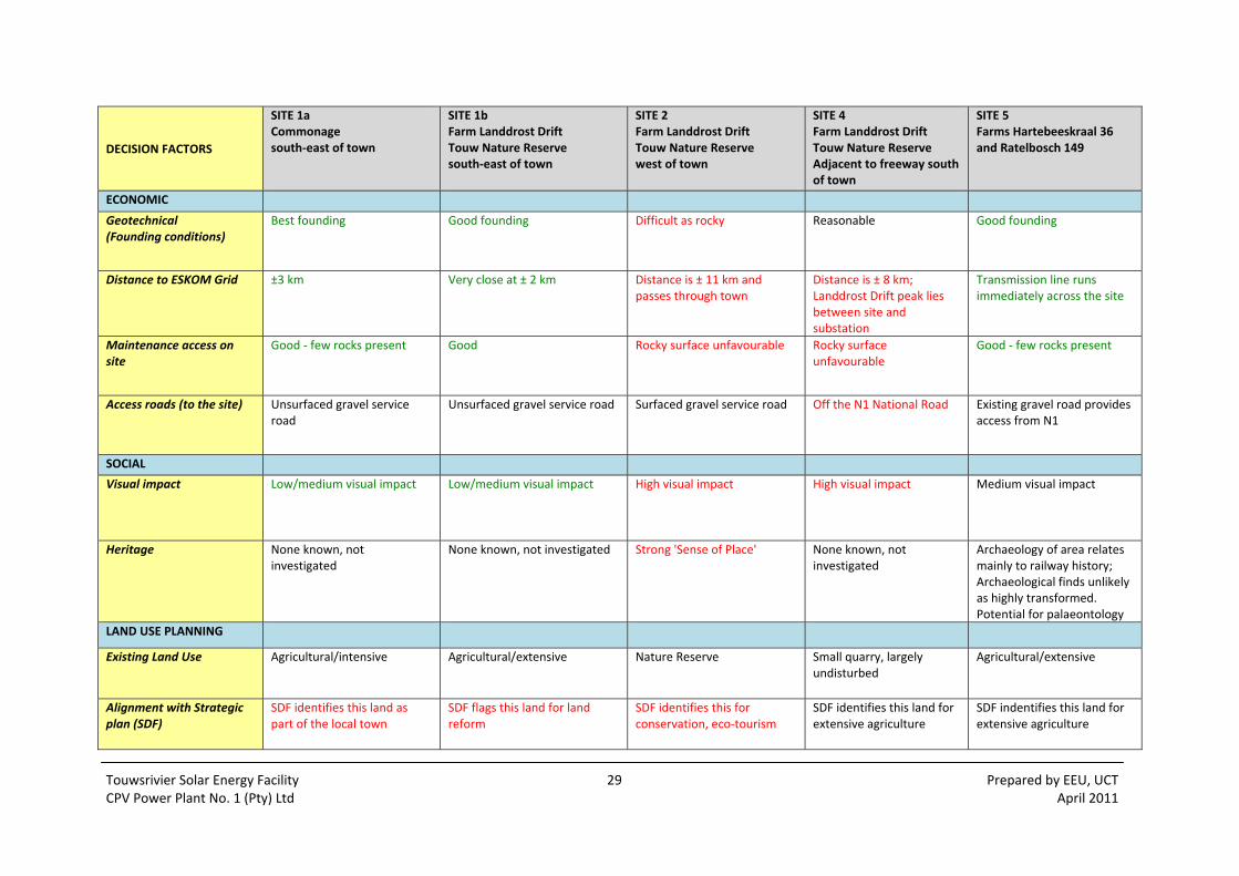
Touwsrivier Solar Energy Facility 29 Prepared by EEU, UCT CPV Power Plant No. 1 (Pty) Ltd April 2011
DECISION FACTORS
SITE 1a Commonage south‐east of town
SITE 1b Farm Landdrost Drift Touw Nature Reserve south‐east of town
SITE 2 Farm Landdrost Drift Touw Nature Reserve west of town
SITE 4 Farm Landdrost Drift Touw Nature Reserve Adjacent to freeway south of town
SITE 5 Farms Hartebeeskraal 36 and Ratelbosch 149
ECONOMIC
Geotechnical (Founding conditions)
Best founding Good founding Difficult as rocky Reasonable Good founding
Distance to ESKOM Grid ±3 km Very close at ± 2 km Distance is ± 11 km and passes through town
Distance is ± 8 km; Landdrost Drift peak lies between site and substation
Transmission line runs immediately across the site
Maintenance access on site
Good ‐ few rocks present Good Rocky surface unfavourable Rocky surface unfavourable
Good ‐ few rocks present
Access roads (to the site) Unsurfaced gravel service road
Unsurfaced gravel service road Surfaced gravel service road Off the N1 National Road Existing gravel road provides access from N1
SOCIAL
Visual impact Low/medium visual impact Low/medium visual impact High visual impact High visual impact Medium visual impact
Heritage None known, not investigated
None known, not investigated Strong 'Sense of Place' None known, not investigated
Archaeology of area relates mainly to railway history; Archaeological finds unlikely as highly transformed. Potential for palaeontology
LAND USE PLANNING
Existing Land Use Agricultural/intensive Agricultural/extensive Nature Reserve Small quarry, largely undisturbed
Agricultural/extensive
Alignment with Strategic plan (SDF)
SDF identifies this land as part of the local town
SDF flags this land for land reform
SDF identifies this for conservation, eco‐tourism
SDF identifies this land for extensive agriculture
SDF indentifies this land for extensive agriculture
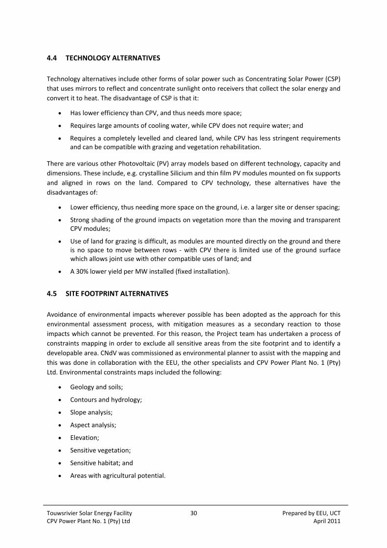
Touwsrivier Solar Energy Facility 30 Prepared by EEU, UCT CPV Power Plant No. 1 (Pty) Ltd April 2011
4.4 TECHNOLOGY ALTERNATIVES
Technology alternatives include other forms of solar power such as Concentrating Solar Power (CSP)
that uses mirrors to reflect and concentrate sunlight onto receivers that collect the solar energy and
convert it to heat. The disadvantage of CSP is that it:
Has lower efficiency than CPV, and thus needs more space;
Requires large amounts of cooling water, while CPV does not require water; and
Requires a completely levelled and cleared land, while CPV has less stringent requirements and can be compatible with grazing and vegetation rehabilitation.
There are various other Photovoltaic (PV) array models based on different technology, capacity and
dimensions. These include, e.g. crystalline Silicium and thin film PV modules mounted on fix supports
and aligned in rows on the land. Compared to CPV technology, these alternatives have the
disadvantages of:
Lower efficiency, thus needing more space on the ground, i.e. a larger site or denser spacing;
Strong shading of the ground impacts on vegetation more than the moving and transparent CPV modules;
Use of land for grazing is difficult, as modules are mounted directly on the ground and there is no space to move between rows ‐ with CPV there is limited use of the ground surface which allows joint use with other compatible uses of land; and
A 30% lower yield per MW installed (fixed installation).
4.5 SITE FOOTPRINT ALTERNATIVES
Avoidance of environmental impacts wherever possible has been adopted as the approach for this
environmental assessment process, with mitigation measures as a secondary reaction to those
impacts which cannot be prevented. For this reason, the Project team has undertaken a process of
constraints mapping in order to exclude all sensitive areas from the site footprint and to identify a
developable area. CNdV was commissioned as environmental planner to assist with the mapping and
this was done in collaboration with the EEU, the other specialists and CPV Power Plant No. 1 (Pty)
Ltd. Environmental constraints maps included the following:
Geology and soils;
Contours and hydrology;
Slope analysis;
Aspect analysis;
Elevation;
Sensitive vegetation;
Sensitive habitat; and
Areas with agricultural potential.
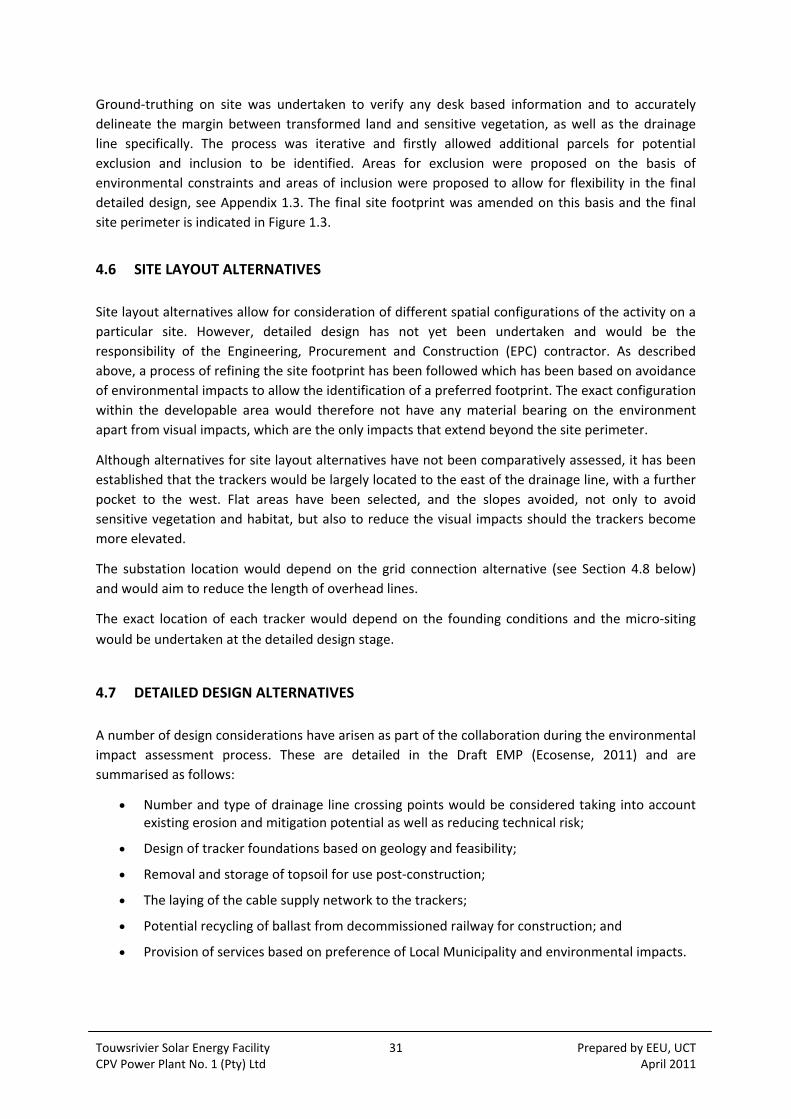
Touwsrivier Solar Energy Facility 31 Prepared by EEU, UCT CPV Power Plant No. 1 (Pty) Ltd April 2011
Ground‐truthing on site was undertaken to verify any desk based information and to accurately
delineate the margin between transformed land and sensitive vegetation, as well as the drainage
line specifically. The process was iterative and firstly allowed additional parcels for potential
exclusion and inclusion to be identified. Areas for exclusion were proposed on the basis of
environmental constraints and areas of inclusion were proposed to allow for flexibility in the final
detailed design, see Appendix 1.3. The final site footprint was amended on this basis and the final
site perimeter is indicated in Figure 1.3.
4.6 SITE LAYOUT ALTERNATIVES
Site layout alternatives allow for consideration of different spatial configurations of the activity on a
particular site. However, detailed design has not yet been undertaken and would be the
responsibility of the Engineering, Procurement and Construction (EPC) contractor. As described
above, a process of refining the site footprint has been followed which has been based on avoidance
of environmental impacts to allow the identification of a preferred footprint. The exact configuration
within the developable area would therefore not have any material bearing on the environment
apart from visual impacts, which are the only impacts that extend beyond the site perimeter.
Although alternatives for site layout alternatives have not been comparatively assessed, it has been
established that the trackers would be largely located to the east of the drainage line, with a further
pocket to the west. Flat areas have been selected, and the slopes avoided, not only to avoid
sensitive vegetation and habitat, but also to reduce the visual impacts should the trackers become
more elevated.
The substation location would depend on the grid connection alternative (see Section 4.8 below)
and would aim to reduce the length of overhead lines.
The exact location of each tracker would depend on the founding conditions and the micro‐siting
would be undertaken at the detailed design stage.
4.7 DETAILED DESIGN ALTERNATIVES
A number of design considerations have arisen as part of the collaboration during the environmental
impact assessment process. These are detailed in the Draft EMP (Ecosense, 2011) and are
summarised as follows:
Number and type of drainage line crossing points would be considered taking into account existing erosion and mitigation potential as well as reducing technical risk;
Design of tracker foundations based on geology and feasibility;
Removal and storage of topsoil for use post‐construction;
The laying of the cable supply network to the trackers;
Potential recycling of ballast from decommissioned railway for construction; and
Provision of services based on preference of Local Municipality and environmental impacts.
Touwsrivier Solar Energy Facility 32 Prepared by EEU, UCT CPV Power Plant No. 1 (Pty) Ltd April 2011
4.8 GRID CONNECTION ALTERNATIVES
In the Scoping Phase it was originally intended to connect to the existing 66 kV Eskom transmission
line on‐site, which would feed the electricity directly into the national grid. However, after having
carried out appropriate grid studies and in consultation with Eskom, it has emerged that the only
suitable option for connection of the 50 MW power plant to the national grid in terms of technical
feasibility would be to the existing 132 kV Eskom transmission line a few kilometers to the south of
the site. Eskom has however advised that authorisation to connect to both 66 and 132 kV lines
should be sought on the basis that the full capacity on the 132 kV line may be allocated to other
developer/s, rendering this option unavailable (see Appendix 1.1). A site visit was held on 11
February to establish the most suitable alignment for a new 132 kV line and two new options for grid
connection where thus identified. See Option 1a and Option 1b on Figure 1.4. These options are
summarised in Table 4.2.
Option 1a connects to the existing 132 kV line to the south‐east of the site and involves
approximately 5 km of transmission line to be constructed on Hartebeeskraal (1/36) parallel to the
perimeter fence and the existing access track. This land is on the same farm portion as the proposed
site.
Option 1b connects to the existing 132 kV line to the east of the site and is proposed to run in
parallel (and to the south of) the existing Eskom 66 kV line and Transnet railway line. The length of
this option is more than 7 km and passes over Farms 740 and RE/34. On Farm 740 the land use is
game farming with a potential commercial hunting activity in the future and on the relevant part of
Farm RE/34 the current land use is ostrich breeding camps.
Option 2 is based on the original proposal to connect on‐site to the existing 66 kV line, thus avoiding
the need for a transmission line. This connection however would not accommodate the full capacity
of 50 MW being fed into the grid. Therefore, the 50 MW project would not be economically feasible
under these conditions.
Table 4.2: Technical Description of Grid Connection Options
Option 1a Option 1b Option 2
Connection 5 km new transmission line required to connect to the 132 kV line to the south‐east
7 km new transmission line required to connect to the 132 kV line to the south‐east
On site connection to 66 kV line
Capacity Full 50 MW capacity Full 50 MW capacity Less capacity which puts the project feasibility at risk.
Existing Land Use
Former agricultural land and game farming. Commercial hunting on the adjacent Farm 740 proposed in next 1‐2 years.
Former agricultural land and game farming. Commercial hunting on Farm 740 proposed in next 1‐2 years. Ostrich breeding camps on the relevant stretch of RE/34 at present, with cattle and sheep elsewhere on the farm.
N/A – on site

Touwsrivier Solar Energy Facility 33 Prepared by EEU, UCT CPV Power Plant No. 1 (Pty) Ltd April 2011
Option 1a Option 1b Option 2
Land Take 5 km long ±52 m wide (servitude)
7+ km long ±52 m wide (servitude)
N/A – on site
Topography Mostly flat apart from the saddle between two outcrops.
Flat N/A – on site
Road access Traverses private land with existing road access all along proposed route.
Road access along the entire route (via Transnet/Eskom service roads) and private farm roads. Short section of new access road would be required at eastern end.
N/A
Land availability / ownership
Part of farm portion required for main site ‐Hartebeeskraal (1/36), and a very short section of the existing Eskom servitude for the 132 kV line crossing property 740.
Lease required on two farms 740 and RE/34.
N/A
Servitudes (Eskom and Transnet)
Will only traverse Eskom’s servitude where it connects to grid.
May need to cross the existing 66 kV line and servitude. Must avoid the existing railway servitudes.
N/A
4.9 INPUT
At this early stage of the Project, the preferred contractors have not yet been selected and therefore
the contribution of local goods, services and labour cannot yet be established in detail. The extent of
local contributions has been identified as a socio‐economic impact and assessed in the SIA (see
Section 11). The formulation of appropriate labour recruitment strategies and the creation of
opportunities for local and regional Small, Micro and Medium Enterprise (SMMEs) and other
business during construction and operation would be considered to ensure that socio‐economic
benefits are retained in the local area.
4.10 SUMMARY
The final site layout would be refined during detailed design however for the purposes of the EIA,
the specialists have comparatively assessed the following alternatives:
No‐Go Option;
Grid Connection Option 1a (5 km of new 132 kV transmission line required to south‐east);
Grid Connection Option 1b (7 km of new 132 kV transmission line required to east); and
Grid Connection Option 2 (on‐site connection to existing 66 kV line).

Touwsrivier Solar Energy Facility 34 Prepared by EEU, UCT CPV Power Plant No. 1 (Pty) Ltd April 2011

Touwsrivier Solar Energy Facility 35 Prepared by EEU, UCT CPV Power Plant No. 1 (Pty) Ltd April 2011
5 NEED AND DESIRABILITY
5.1 INTRODUCTION
According to the DEA&DP Guideline on Need and Desirability (August 2010), the EIA process is
responsible for evaluating whether the Project is justified in terms of environmental, social and
economic sustainability. Consideration of the strategic context of the proposed Project along with
the broader societal needs and the public interest is required. The guidelines go further to state that
the need and desirability of the Project must be measured against the contents of the current
developmental and spatial planning documents, thus aligning with the vision for the area.
Specifically, “the concept of need and desirability can be explained in terms of the general meaning
of its two components in which need refers to time and desirability to place – i.e. is this the right
time and is it the right place for locating the type of land‐use/activity being proposed”(p:9).
5.2 NEED
Need or ‘timing’ of the development can be seen in light of the present global trend towards
renewable energy which is largely based on initiatives to reduce the dependency on fossil fuels, the
emission of greenhouse gases and their impacts on climate change. South Africa has made a
commitment to the promotion of renewable energy in the Johannesburg Declaration as part of the
Johannesburg World Summit on Sustainable Development in 2002. Furthermore, South Africa has
already ratified the United Nations Framework Convention on Climate Change (1992) and the Kyoto
Protocol (1997), which creates international incentives to invest in emission reduction projects in
developing countries such as South Africa. More recently, South Africa has submitted an emission
mitigation pledge to the UNFCCC under the Copenhagen Accord (2009) which sets out emission
reduction targets.
The legislation and policy context for energy and specifically renewable energy in South Africa is
listed in Table 6.2 and also discussed in Section 6.3 (Energy Legal and Regulatory Framework) and
Section 11.1 (Social Impacts). The key legislation and policy is briefly reiterated here. The National
Energy Act (Act 34 of 2008) aims to ensure that diverse energy resources are available, in sustainable
quantities and at affordable prices, to the South African economy in support of economic growth
and poverty alleviation. The Act recognises that environmental management requirements are taken
into account in planning and that increased generation of renewable energies is required.
The White Paper on Renewable Energy (2003) recognises that the potential for renewable energy in
South Africa is significant and is a policy setting out how renewable energy will be promoted and
implemented. The White Paper sets a target of 10,000 GWh renewable energy contribution to final
energy consumption by 2013. This renewable energy is to be produced mainly from biomass, wind,
solar and small‐scale hydro.
The strategic level mix and contribution of renewable energy generation types in South Africa has
been considered in the draft National Integrated Resource Plan (IRP) 2010 published by the
Department of Energy (DoE) in consultation with National Energy Regulator (NERSA). The IRP is a
long‐term electricity capacity plan that directs expansion of the electricity supply over the period of
20 years. Its stated objective is to provide a mechanism by which electricity systems, sustainability

Touwsrivier Solar Energy Facility 36 Prepared by EEU, UCT CPV Power Plant No. 1 (Pty) Ltd April 2011
and government policy requirements are met, and more specifically what the appropriate mix of
technologies is to meet the needs of the country. The IRP 2010 has been approved by Cabinet and is
likely to be promulgated in the first quarter of 2011, it sets out the preferred contribution of
renewable energy to the energy mix.
The NERSA Renewable Energy Feed‐In Tariff (REFIT) Guidelines published in 2009 under the
Electricity Regulation Act (Act 4 of 2006) guarantee attractive rates of payment for renewable energy
sold back to the grid, thereby encouraging investment in the various sub‐sectors of renewable
energy. In 2010, NERSA published ‘Rules on Selection Criteria for Renewable Energy Projects under
the REFIT Programme’ which sets out criteria which renewable energy or cogeneration Independent
Power Producers (IPPs) must comply with to qualify for licences.
In the Western Cape, the White Paper on Sustainable Energy for the Western Cape Province (2010)
sets out a target for the Province. It is stipulated that 15% of electricity consumed in the Province
will come from renewable energy sources by 2014 (measured against 2006 Provincial consumption).
As this legal and policy framework depicts, it has been recognised that in order to fulfil international
commitments to sustainable development and climate change, renewable energy is to be promoted
and this will ensure a diversification of electricity supply and energy security. As stated by Edkins et
al (2010, p:v), “it seems that the renewable energy market in South Africa is set to go, especially
since the announcement of REFIT”.
More specifically, solar energy is one of a number of freely available sources for renewable power
generation. Due to its geographical position, the 24 hour solar radiation average for South Africa is
220 W/m2 while that in the USA and Europe are 150 W/m2 and 100 W/m2 respectively (Davidson et
al, 2006). Even though the amount of solar radiation experienced across the country varies as shown
in the Figure 5.1 overleaf, South Africa has a huge potential for the exploitation of solar power as a
source of renewable energy. However in South Africa, related technology (both PV and CSP) is still in
its infancy and to date, there has been little deployment of solar technology with no existing large
scale grid‐connected projects (Edkins et al, 2010).
Photovoltaic systems in particular can be used to harvest the energy in sunlight and convert it into
electricity. PV in general often has the least impact on the surrounding environment in terms of
emissions, waste, and noise. See Section 4.4 (Technology Alternatives) above for a comparison of
the efficiency of Concentrix™ (now Soitec’s) PV in comparison to conventional PV or CSP. In
summary, this particular technology developed by Concentrix Solar (now Soitec) has the following
environmental characteristics as set out in the 2010 brochure:
Best energy yield for a given area;
Minimal water consumption;
Superior energy payback time (<1 year); and
Most environmentally friendly technology because of its recyclability.
PV in general is also recognised as a relatively young, high‐tech industry, which will assist in creating
jobs and strengthening the economy (US DoE, 2010). This is supported by the findings in a recent
publication by Greenpeace Africa (Rutovitz, 2010) which has shown that in South Africa, PV has the
highest potential employment benefits (52.3 job years/MW) during construction (installation
excluding manufacture) than any other form of energy, with solar thermal having the potential for
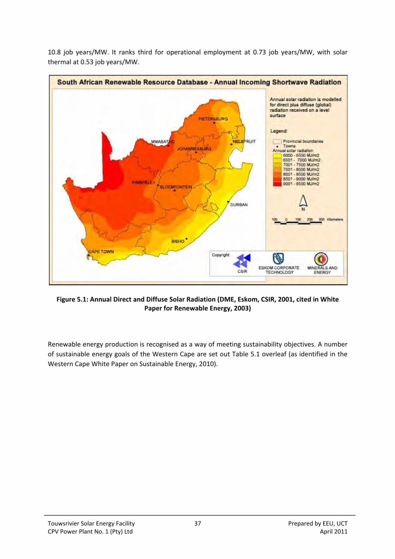
Touwsrivier Solar Energy Facility 37 Prepared by EEU, UCT CPV Power Plant No. 1 (Pty) Ltd April 2011
10.8 job years/MW. It ranks third for operational employment at 0.73 job years/MW, with solar
thermal at 0.53 job years/MW.
Figure 5.1: Annual Direct and Diffuse Solar Radiation (DME, Eskom, CSIR, 2001, cited in White Paper for Renewable Energy, 2003)
Renewable energy production is recognised as a way of meeting sustainability objectives. A number
of sustainable energy goals of the Western Cape are set out Table 5.1 overleaf (as identified in the
Western Cape White Paper on Sustainable Energy, 2010).

Touwsrivier Solar Energy Facility 38 Prepared by EEU, UCT CPV Power Plant No. 1 (Pty) Ltd April 2011
Table 5.1: Sustainability energy goals
Social sustainability
Goal 1: Alleviate energy poverty. The links between energy poverty and under‐development clearly exist. While the poor do have electricity, households either have no or few electrical appliances. If they do these are typically very inefficient appliances for example old refrigerators or hot plates for heating and cooking. Many of the informal settlements are regularly the scenes of large scale fires caused by the use of paraffin stoves in unsafe conditions. The cost of preparing meals or heating a room is typically higher for the poor than for people who can afford efficient and appropriate technologies. Time spent to access energy also disadvantages the poor.
Goal 2: Improve the health of the nation. Energy efficiency and increased use of renewable energy reduces the atmospheric emission of harmful substances such as smoke, oxides of sulphur and oxides of nitrogen. Such substances are known to have an adverse effect on health and are frequently a primary cause of common respiratory ailments. The health of the nation includes improving the health of the individual through improved indoor climate as well as the outdoor climate. Poor air quality (pollution) impacts on health and contributes to increases in respiratory diseases.
Environmental sustainability
Goal 3: Reduce harmful emissions. Improved energy efficiency and increased use of renewable energy are cost effective methods to reduce greenhouse gas emissions, thereby combating climate change. Addressing climate change opens the door to utilising additional finance mechanisms such as the Clean Development Mechanism (CDM) to reduce CO2 emissions
Goal 4: Reduce negative footprints in our environment. The use of fossil fuels has a documented negative impact on the regional and local environment and biodiversity. The negative impact includes but is not limited to, ground water pollution and air pollution. Any reduction in the use of fossil fuels through switching to cleaner energy sources and more efficient energy uses is a success.
Economic sustainability
Goal 5: Enhance Energy Security. The South African power black‐outs that started first in the Western Cape in early 2006 alerted the Province to its energy vulnerability. It is essential that the Western Cape increases its resilience against external energy supply disruptions and the massive price fluctuations caused by national or international decisions.
Goal 6: Improve economic competitiveness and job creation. It has been demonstrated internationally that one of the ways to improve economic competitiveness is by improving industrial and commercial energy efficiency. Support of industrial best practice energy management as a tool to stay competitive and improve the economy is important.
Source: Western Cape White Paper on Sustainable Energy, 2010
It is therefore evident that the current environment for renewable energy is an enabling one and
IPPs for solar energy in particular would be able to play a part in providing a more socially,
environmentally and economically sustainable form of energy.
5.3 DESIRABILITY
Desirability or ‘placing’ of the development has been assessed on a number of levels. Firstly with
regards to the environmental impact, a preliminary site selection process has been undertaken prior
to Scoping in 2009. This exercise iteratively identified and evaluated 5 location alternatives for the
Project, and the site on Hartebeeskraal (1/36) and Ratelbosch (4/149) was found most favourable in
terms of the criteria which included type and quality of vegetation, presence of rare plant species,
soil type and depth, and the hydrology. Since the land was primarily used for activities such as
agriculture and grazing, the vegetation has been irreversibly changed. There is alien vegetation
(Kraalbos) on the site with some patches of natural vegetation which has been severely damaged by

Touwsrivier Solar Energy Facility 39 Prepared by EEU, UCT CPV Power Plant No. 1 (Pty) Ltd April 2011
overgrazing. The poor agricultural potential of the site is evident by the failed attempts at
rehabilitation in the 1990’s, as recorded by Coetzee (2011) and summarised in Section 8.5. Other
transformation has occurred in relation to the historical and current industrial land uses, namely the
railway/s, the substation, the overhead lines and the N1. Development of the Project in this
particular location would therefore have few negative environmental impacts and proper mitigation
measures could reduce its environmental impact. Details of the site selection process are set out in
Section 4.3.1 and include a brief assessment of the alignment with the strategic plan further detailed
below.
The SIA (Barbour and van der Merwe, 2011) includes a review of developmental and spatial plans
relevant to the area and assesses the implications for the Project thereupon (see Section 6.4 and
Section 11.1). According to the BVM IDP 2007‐2012, unemployment and poverty levels in the
Touwsrivier region are higher than the national level with very low education and skills levels. The
IDP has also identified that addressing HIV/Aids and alcohol and drug abuse were significant
challenges faced in the Municipality. As reported in the 2008 BVM Long Term Growth and Economic
Development Strategy (LTGEDS) and the 2006 BVM SDF, the town itself is suffering from an
unemployment rate of about 50%. In terms of the economy, the LTGEDS argued that there is the
need for a shift from solely depending on agriculture as the economic pillar to a diversification
strategy. However, the SDF indicates that the proposed site and surrounds are designated for
‘extensive agricultural’ use. The above mentioned documents concluded that job creation should be
viewed as the one of the most important economic and social issues to be addressed in the area.
This could be achieved through the promotion of private investment in the area which could
potentially result in the creation of long term sustainable jobs. The proposed development would
offer approximately 200 to 300 jobs during the 24‐27 months construction phase and 100 to 140
permanent jobs during the 25‐30 years operational phase. The cost of the proposed development
amounts to approximately R500‐800 million, out of which a portion would be injected in the local
economy through job creation and associated spend. Additionally, the developer would provide
training opportunities thus empowering the beneficiaries and equipping them with long term skills.
A number of BVM officials have been consulted and are in favour of the proposed Project on this
basis, with reservations regarding the visual impact of the Project. Although the land use is zoned as
agricultural, the conditions on the site are not favourable for agriculture in terms of water supply
and soil conditions (see Section 8.5 and the Agricultural Potential Report as Appendix 8.2).
It is thus evident that the Project is desirable in terms of its contribution to the vision for the area
through the generation of employment opportunities, and would also allow for rehabilitation of the
site which would lead to an overall improvement of the environmental quality in the area.

Touwsrivier Solar Energy Facility 40 Prepared by EEU, UCT CPV Power Plant No. 1 (Pty) Ltd April 2011

Touwsrivier Solar Energy Facility 41 Prepared by EEU, UCT CPV Power Plant No. 1 (Pty) Ltd April 2011
6 LEGAL, PLANNING AND POLICY CONTEXT
6.1 SUMMARY OF LEGAL, PLANNING AND POLICY FRAMEWORK
All legislation, plans and policies relating to the proposed Project, either in terms of environmental
management, renewable energy or spatial planning, has been included in the tables below. Table 6.1
provides a summary of the relevant environmental legislation and policy, and spatial planning
documents. Table 6.2 thereafter sets out the relevant energy legislation and policy. Only the key
legislation and policy, is described in relation to the Project in Sections 6.2, 6.3 and 6.4 below.
Guidelines specifically applicable to EIA are referred to in Section 6.5 thereafter.
Table 6.1: Relevant Environmental Legislation and Policy
International
Johannesburg World Summit on Sustainable Development (2002): Johannesburg Declaration
National
Legislation Constitution of the Republic of South Africa ( 1996)
National Environmental Management Act (107 of 1998): EIA Regulations, 2006 & 2010
Environment Conservation Act (73 of 1989) (ECA)
National Heritage Resources Act (25 of 1999) (NHRA)
National Environmental Management: Biodiversity Act (10 of 2004)
National Environmental Management: Protected Areas Act (57 of 2003)
National Water Act (36 of 1998) (NWA)
National Environment Management: Air Quality Act (Act 39 of 2004)
National Environmental Management: Waste Act (59 of 2008)
Conservation of Agricultural Resources Act (43 of 1983)
National Veld and Forest Fire Act (101 of 1998)
Occupational Health and Safety Act (85 of 1993)
Hazardous Chemical Substances Regulations (1995)
Policy and Planning White Paper on Environmental Management Policy for SA (1997)
White Paper on Conservation and Sustainable Utilisation of Biodiversity (1997)
National Framework for Sustainable Development (NFSD) (2008)
Provincial
Legislation Land Use Planning Ordinance (LUPO) (1985)
Western Cape Nature Conservation Board Act (15 of 1998)
Western Cape Planning and Development Act (1999)
Western Cape Nature Conservation Laws Amendment Act (3 of 2000)
Western Cape Planning and Development Amendment Bill (2002)
Western Cape National Environmental Management Protected Areas Bill (2003)
Western Cape Tourism Act (2004)
Policy and Planning Bioregional Planning Framework for the Western Cape Province (2000)
White Paper on Sustainable Tourism Development and Promotion in the Western Cape (2001)
Western Cape Sustainable Development Implementation Plan (SDIP) (2007)
Ikapa Growth and Development Strategy (2008)
Western Cape Provincial Spatial Development Framework (PSDF) (2009)

Touwsrivier Solar Energy Facility 42 Prepared by EEU, UCT CPV Power Plant No. 1 (Pty) Ltd April 2011
Municipal
Policy and Planning Cape Winelands Spatial Development Framework (CWSDF) (2005)
Cape Winelands District Municipality Growth and Development Strategy (2006)
Cape Winelands District Municipality Integrated Development Plan (IDP) (Second Review of the 2nd Generation IDP (2007/11) (2009/10)
Breede Valley Local Municipality Spatial Development Framework (2004)
Breede Valley Local Municipality Integrated Development Plan (2007‐2012)
Breede Valley Municipality Long Term Growth and Economic Development Strategy (2008)
Breede Valley Municipality “Broad‐brush” Spatial Development Framework (2006)
Table 6.2: Relevant Energy Legislation and Policy
International
The Copenhagen Accord (2009)
Kyoto Protocol (1997) (Including Clean Development Mechanism 2006)
Johannesburg World Summit on Sustainable Development in (2002): Johannesburg Declaration
United Nations Framework Convention on Climate Change (1992)
National
Electricity Act (41 of 1987)
White Paper on the Energy Policy of the Republic of SA (1998)
Implementation Strategy for Renewable Energy in South Africa (2000)
White Paper on Renewable Energy (2003)
Electricity Regulation Act (4 of 2006)
National Energy Act (34 of 2008)
Energy Security Master Plan – Electricity: 2007‐2025 (2008)
Electricity Regulations on New Generation Capacity (2009)
NERSA, South Africa Renewable Energy Feed‐In Tariff (REFIT): Regulatory Guidelines, 26 March 2009 (Phase 1)NERSA, South Africa Renewable Energy Feed‐In Tariff (REFIT): 29 October 2009 (Phase 2)
NERSA, Rules on Selection Criteria for Renewable Energy Projects under the REFIT Programme (2010)
Draft Integrated Resource Plan for Electricity (for Comment) (2010)
Integrated Resource Plan for Electricity (2010)
Provincial
White Paper on Sustainable Energy for The Western Cape Province (2010)
A Proposed Renewable Energy Plan of Action for the Western Cape: Resource Assessment, Scenarios, Proposed Objectives and Actions (May 2007)
Western Cape Sustainable Development Implementation Plan (August, 2007)
Western Cape Sustainable Energy Strategy and Programme of Action (March 2008)
A Climate Change Strategy and Action Plan for the Western Cape (March 2008)
Strategic Initiative to Introduce Commercial Land Based Wind Energy Development to the Western Cape: Towards a Regional Methodology for Wind Energy Site Selection (2006)
6.2 ENVIRONMENTAL LEGAL AND REGULATORY FRAMEWORK
6.2.1 The Constitution, Act 108 of 1996
The Constitution of the Republic of South Africa (Act 108 of 1996) has been adopted as the supreme
law of the country and forms the foundations for a democratic society in which fundamental human
rights are protected. In terms of the environment, Chapter 2 Section 24 states that everyone has a
right:

Touwsrivier Solar Energy Facility 43 Prepared by EEU, UCT CPV Power Plant No. 1 (Pty) Ltd April 2011
To an environment that is not harmful to their health or well‐being; and
To have the environment protected, for the benefit of present and future generations, through reasonable legislative and other measures that ‐
prevent pollution and ecological degradation;
promote conservation; and
secure ecologically sustainable development and use of natural resources while promoting justifiable economic and social development.
Relevance to the Project
Encouraging investment in the renewable energy sector demonstrates government commitment to
protecting the environment from future resource depletion, as well as conservation of natural
resources while promoting economic development.
6.2.2 National Environmental Management Act (107 of 1998) (NEMA)
NEMA (107 of 1998) is the key legislation setting out the framework for environmental
management in South Africa. The Act promotes cooperative environmental governance and
establishes principles for decision‐making on matters affecting the environment. An overarching
principle in Chapter 1 emphasises that development must be socially, environmentally and
economically sustainable. Sustainable development is considered to include the following:
i) That the disturbance of ecosystems and loss of biological diversity are avoided, or, where
they cannot be altogether avoided, are minimised and remedied;
ii) That pollution and degradation of the environment are avoided, or, where they cannot be
altogether avoided, are minimised and remedied;
iii) That the disturbance of landscapes and sites that constitute the nation´s cultural heritage is avoided, or where it cannot be altogether avoided, is minimised and remedied;
iv) That waste is avoided, or where it cannot be altogether avoided, minimised and reused or
recycled where possible and otherwise disposed of in a responsible manner;
v) That the use and exploitation of non‐renewable natural resources is responsible and
equitable, and takes into account the consequences of the depletion of the resource;
vi) That the development, use and exploitation of renewable resources and the ecosystems of
which they are part do not exceed the level beyond which their integrity is jeopardised;
vii) That a risk‐averse and cautious approach is applied, which takes into account the limits of
current knowledge about the consequences of decisions and actions; and
viii) That negative impacts on the environment and on people´s environmental rights be anticipated and prevented, and where they cannot be altogether prevented, are minimised and remedied.
Specifically, Chapter 5 deals with Integrated Environmental Management and promotes the
application of appropriate tools. The ‘EIA Regulations’ published in GN R385 of April 21 2006 in
terms of Section 24(5) of NEMA require that certain activities listed in GN R386 of April 21 2006 will
require a ‘Basic Assessment’, and those in and GN R387 of April 21 2006 will require a ‘Scoping and
EIA’ respectively before they can proceed.

Touwsrivier Solar Energy Facility 44 Prepared by EEU, UCT CPV Power Plant No. 1 (Pty) Ltd April 2011
Relevance to the Project
This project includes a number of listed activities which collectively form part of the proposal. Those
activities falling under GN R387 trigger the requirement for a Scoping and EIA and are described in
Table 6.3 whilst those falling under GN R386 are set out in Table 6.4 thereafter.
Table 6.3: Activities requiring Scoping and EIA
Government Notice 387, 1 The construction of facilities or infrastructure, including associated structures or infrastructure, for– (a) the generation of electricity where – (i) the electricity output is 20 megawatts or more; or (ii) the elements of the facility cover a combined area in excess of 1 hectare;
Government Notice 387 (1) The construction of facilities or infrastructure, including associated structures or infrastructure, for– (l) the transmission and distribution of above ground electricity with a capacity of 120 kilovolts or more;
Government Notice 387, 2 Any development activity, including associated structures and infrastructure, where the total area of the developed area is, or is intended to be, 20 ha or more.
Table 6.4: Activities requiring Basic Assessment
Government Notice 386, 1 The construction of facilities or infrastructure, including associated structures and infrastructure for‐ (k) the bulk transportation of sewage and water, including storm water, in pipelines with ‐ (i) an internal diameter of 0,36 metres or more; or (ii) a peak throughput of 120 litres per second or more;
Government Notice 386, 1 The construction of facilities or infrastructure, including associated structures and infrastructure for‐ (m) any purpose in the one in ten year flood line of a river or stream, or within 32 metres from the bank of a river or stream where the flood line is unknown, excluding purposes associated with existing residential use, but including – (i) canals; ‐ (ii) channels; (iii) bridges; (iv) dams; and (v) weirs
Government Notice 386, 1 The construction of facilities or infrastructure, including associated structures and infrastructure for‐ (s) the treatment of effluent, wastewater or sewage with an annual throughput capacity of more than 2 000 cubic metres but less than 15 000 cubic metres;
Government Notice 386, 4 The dredging, excavation, infilling, removal or moving of soil, sand or rock exceeding 5 cubic metres from a river, tidal lagoon, tidal river, lake, in‐stream dam, floodplain or wetland.
Government Notice 386, 7 The above ground storage of a dangerous good, including petrol, diesel, liquid petroleum gas or paraffin, in containers with a combined capacity of more than 30 cubic metres but less than 1 000 cubic metres at any one location or site.
Government Notice 386, 13 The abstraction of groundwater at a volume where any general authorisation issued in terms of the National Water Act, 1998 (Act No. 36 of 1998) will be exceeded.

Touwsrivier Solar Energy Facility 45 Prepared by EEU, UCT CPV Power Plant No. 1 (Pty) Ltd April 2011
Government Notice 386, 14 The construction of masts of any material or type and of any height, including those used for telecommunication broadcasting and radio transmission, but excluding ‐ (a) masts of 15 metres and lower exclusively used (i) by radio amateurs; or (ii) for lighting purposes (b) flag poles; and (c) lightning conductor poles.
Government Notice 386, 15 The construction of a road that is wider than 4 metres or that has a reserve wider than 6 metres, excluding roads that fall within the ambit of another listed activity or which are access roads of less than 30 metres long.
Government Notice 386, 19 The development of a new facility or the transformation of an existing facility for the conducting of manufacturing processes, warehousing, bottling, packaging, or storage, which, including associated structures or infrastructure, occupies an area of 1 000 square metres or more outside an existing area zoned for industrial purposes.
As the project design has progressed, the listed activities have been refined. A number have been
removed however the activity to construct a transmission line of 33 to 120 kV has been replaced
with a capacity of over 120 kV to accommodate the grid connection. The Tables above reflect the
final list and a description is provided in Appendix 6.1.
Amended EIA Regulations ‐ 2010
The NEMA EIA Amendment Regulations of 2010 were promulgated on 18 June 2010 and came into
effect on 2 August 2010 to replace the previous EIA Regulations promulgated on 21 April 2006.
These Regulations appear in Government Notice No. R 543, R 544, R 545, R 546 and R 547 in
Government Gazette No. 33306 of 18 June 2010. The procedure and criteria for the submission,
processing and consideration of, and decision on, applications for environmental authorisations is
set out in GN R543 and the three new Listing Notices are set out as follows: Listing Notice 1 (R544),
Listing Notice 2 (R545) and Listing Notice 3 (R546).
GN543 (76) makes provision for transitional arrangements in relation to applications that are
pending. If the situation arises whereby the application involves listed activities similar to those set
out in the 2006 EIA Listing Notices, then the competent authority may authorise the application
under the previous 2006 EIA Regulations as if they had not been repealed. If there is an activity not
listed under the previous EIA Regulations, then the application may only be dispensed on the
condition that all impacts of the newly listed activity and requirements of these regulations have
also been considered and adequately assessed by the applicant.
Appendix 6.1 sets out a comparison of the 2006 Listed Activities relevant to the Project and
compares the activities to those listed in the 2010 Regulations. In addition, any new activities not
previously listed and applicable to the Project have been identified. All activities are considered and
adequately assessed as required by the Regulations.

Touwsrivier Solar Energy Facility 46 Prepared by EEU, UCT CPV Power Plant No. 1 (Pty) Ltd April 2011
6.2.3 Environment Conservation Act (73 of 1989) (ECA)
The Environment Conservation Act (ECA) has been partially superseded by the promulgation of
NEMA. There are however some chapters of the Act that remain in force (until specifically repealed
by NEMA) and these relate to the protection of the natural environment and the control of
environmental pollution.
Relevance to the Project
Section 8 of the ECA refers to national noise regulations with regard to the control of noise, vibration
and shock. These regulations define noise, vibration and shock and make provision for the
prevention, reduction or elimination of them. The Western Cape Province has however,
promulgated their own Provincial Noise Control Regulations (GN 627, 20 November 1998) in terms
of Section 25 of the ECA.
Section 20 of the ECA sets out waste disposal requirements however most of this has been repealed
by the Waste Act (59 of 2008).
6.2.4 National Heritage Resources Act (25 of 1999) (NHRA)
The purpose of the NHRA is to introduce an integrated and interactive system for the protection of
South Africa’s heritage resources. South African National Heritage Resources Agency (SAHRA) is the
enforcing authority and in the Western Cape, the authority has been delegated to Heritage Western
Cape (HWC) for most cases.
The NHRA has defined certain kinds of heritage as being worthy of protection, by either specific or
general protection mechanisms. Loosely defined, heritage is that which is inherited. In South Africa
the law is directed towards the protection of human‐made heritage, although places and objects of
scientific importance are covered. The NHRA also protects intangible heritage such as traditional
activities, oral histories and places where significant events happened. Generally protected heritage
which must be considered in any heritage assessment includes:
(a) Cultural landscapes and intangible heritage associated with them;
(b) Buildings and structures (greater than 60 years of age);
(c) Archaeological sites (greater than 100 years of age);
(d) Paleontological sites and specimens;
(e) Shipwrecks and aircraft wrecks; and
(f) Graves and grave yards.
The NHRA is the basis for all heritage impact assessments and prescribes the manner in which
heritage is assessed and managed.
Relevance to the Project
Section 38 of the NHRA states that Heritage Impact Assessments (HIAs) are required for certain kinds
of development such as rezoning of land greater than 10 000 m2 in extent or exceeding 3 or more
sub‐divisions, or for any activity that would alter the character or landscape of a site greater than
5,000 m2. “Standalone HIAs” are not required where an EIA is carried out as long as the EIA contains
an adequate HIA component that fulfils Section 38 provisions (Hart, 2011).

Touwsrivier Solar Energy Facility 47 Prepared by EEU, UCT CPV Power Plant No. 1 (Pty) Ltd April 2011
6.2.5 National Environmental Management: Biodiversity Act (10 of 2004)
The Act provides for the management and conservation of South Africa’s biodiversity within the
framework of the NEMA; the protection of species and ecosystems that warrant national protection;
the sustainable use of indigenous biological resources; the fair and equitable sharing benefits arising
from bio‐prospecting involving indigenous biological resources; and the establishment and functions
of a South African National Biodiversity Institute.
Relevance to the Project
Chapter 4 in particular relates to threatened and protected ecosystems and species and related
threatening processes and restricted activities. The EIA has taken into consideration those
indigenous species listed as threatened or protected species in terms of Section 56(1) of the Act.
6.2.6 National Environmental Management: Protected Areas Act (57 of 2003)
The Protected Areas Act relates to the declaration and management of protected areas, nature
reserves and World Heritage Sites. In terms of this Act, no person may enter or reside in the reserve
or site without the written permission of the management authority.
The aim of the Protected Areas Act is “To provide for the protection and conservation of ecologically
viable areas representatives of South Africa’s biologically diversity and its natural landscapes and
seascapes; for the establishment of a national register of all national, provincial and local protected
areas; for the management of those areas in accordance with national norms and standards; for
intergovernmental cooperation and public consultation in matters concerning protected areas; and
for matters in connection therewith”.
Relevance to the Project
Although the site does not fall within a protected area, the Touw Nature Reserve is located
approximately 8 km to the north‐east of the site. The Bokkeriviere Nature Reserve on the Witberg
Mountain is some 10 km to the west.
6.2.7 National Water Act (No 36 of 1998)
The Act provides the framework for the sustainable management of South Africa’s water resources.
It aims to protect, use, develop, conserve, manage and control water resources as a whole,
promoting integrated water resource management that involves participation of all stakeholders.
The Act declares the national government to be the public trustee of the nation’s water (and
groundwater) resources as well as prioritising socio‐economic and environmental needs. The Act is
administered by the national Department of Water Affairs (DWA) via regional offices.
As stated in the Act, some of the key factors taken into account when water management is
concerned include the following:
(a) “Meeting the basic human needs of present and future generations;
(b) Promoting equitable access to water;…
(d) Promoting the efficient, sustainable and beneficial use of water in the public interest;
(e) Facilitating social and economic development;…
Touwsrivier Solar Energy Facility 48 Prepared by EEU, UCT CPV Power Plant No. 1 (Pty) Ltd April 2011
(g) Protecting aquatic and associated ecosystems and their biological diversity;…
(k) Managing floods and droughts.”
Relevance to the Project
Section 19 refers to pollution prevention and places responsibility on the person who owns, controls
or uses the land to take all reasonable measures to prevent pollution of a water resource from
occurring, continuing to occur or recurring as a result of activities on land. Prescribed waste standard
or management practices require compliance.
Section 21 classifies ‘water use’ in respect of requiring a license and these include (a) taking water
from a water source; (i) altering the bed, banks, course or characteristics of a watercourse and (j)
removing, discharging or disposing of water found underground if it is necessary for the efficient
continuation of an activity or for the safety of people. As the project requires the abstraction of
water through boreholes on site and also requires construction of drainages lines crossings on the
site, the relevant licensing or registration procedures would apply as set out in Sections 40‐42.
6.2.8 National Environmental Management: Air Quality Act (39 of 2004)
The Act aims to protect the environment and the health and well‐being of people, through
prevention of air pollution and ecological degradation whilst promoting justifiable economic and
social development. The Act makes provision for national, provincial and local ambient air quality
and emission standards.
Relevance to the Project
Although Regulations have not yet been promulgated, Section 32 and 34 set out measures relating
to the control of dust and noise which would be applicable to the construction phase of the Project.
6.2.9 National Environmental Management: Waste Act (59 of 2008)
In order to protect the environment, the Waste Act regulates waste management by providing
reasonable measures for pollution prevention and ecological degradation thus securing ecological
sustainable development. Some of its key objectives are listed below:
(a) Minimising the consumption of natural resources;
(b) Avoiding and minimising the generation of waste;
(c) Reducing, re‐using, recycling and recovering waste;
(d) Preventing pollution and ecological degradation; and
(e) Securing ecologically sustainable development while promoting justifiable economic and social development.
Relevance to the Project
Chapter 4 sets out waste management measures. In particular, Part 3 (reduction, re‐use, recycling
and recovery of waste) and Part 5 (storage, collection and transportation of waste) are of relevance
to the construction phase of the Project and are referred to in the Draft EMP (Ecosense, 2011).
6.2.10 Conservation of Agricultural Resources Act (43 of 1983) (CARA)

Touwsrivier Solar Energy Facility 49 Prepared by EEU, UCT CPV Power Plant No. 1 (Pty) Ltd April 2011
The Act provides the framework for control of utilisation of the natural agricultural resources in
South Africa to promote the conservation of soil and water resources and vegetation (including
wetlands) and aims to combat and control weeds and the elimination of invader plant species.
Relevance to the Project
Section 5 relates to the prohibition of the spreading of weeds and invader plants and Regulation 15
makes provision for these types of plants. The botanical survey did not identify any such species as
classified in the Act however, the Draft EMP (Ecosense, 2011) has stipulated that control of alien
invasive plants is a key consideration where rehabilitation of vegetation is proposed.
6.2.11 National Veld and Forest Fire Act (101 of 1998)
This Act serves a dual purpose being firstly established to prevent and combat veld, forest and
mountain fires throughout South Africa and secondly to provide for a variety of institutions,
methods and practices for the achieving this. It has numerous implications for fire prevention and
fire fighting.
Relevance to the Project
Section 12(1) relates to the duty of the landowner to prevent fire from spreading to adjoining
properties. Although the veld on site is not prone to veld fires, fire prevention procedures have been
set out in the Draft EMP to reduce the risk of fire and to respond accordingly during both
construction and operational phases (Ecosense, 2011).
6.2.12 Occupational Health and Safety Act (85 of 1993)
This Act provides the legal framework for the health and safety of persons at work and for those in
connection with the use of plant and machinery. According to the Act, the ‘health and safety
standard’ is defined as any standard, irrespective of whether or not the force of the law, which if
applied for the purpose of this act will in the opinion of the Minister promote the attainment of an
object of this Act.
Relevance to the Project
The Act is primarily aimed at ensuring the health and safety of persons at work and visitors and
specifies the basic systems that need to be in place and measures that need to be taken (Ecosense,
2011). Section 9(1) in particular relates to the responsibility of the employers to provide and
maintain as far as reasonably realistic a safe working environment that is not detrimental to the
health of the employees and this would be applicable throughout the lifespan of the Project.
6.2.13 Hazardous Chemical Substances Regulations (1995)
According to regulations, a hazardous chemical substance is defined as “any toxic, harmful,
corrosive, irritant or asphyxiant substance, or a mixture of substances for which:
(a) An occupational exposure limit is prescribed
(b) An occupational exposure is not prescribed, but which creates a hazard to health”
The regulations provide guidelines for the employers and employees on various ways to prevent
health hazards and thus maintain the well‐being of those involved in the proposed development.
Touwsrivier Solar Energy Facility 50 Prepared by EEU, UCT CPV Power Plant No. 1 (Pty) Ltd April 2011
Relevance to the Project
Section 9A(1) relates to handling of hazardous chemical substances and in terms of the Project, the
safety of people working with hazardous chemicals (specifically fuels), as well as safe storage, use
and disposal of containers needs to be ensured (Ecosense, 2011).
6.3 ENERGY LEGAL AND REGULATORY FRAMEWORK
6.3.1 National Energy Act (34 of 2008)
This Act aims to ensure that diverse energy resources are available, in sustainable quantities and at
affordable prices, to the South African economy in support of economic growth and poverty
alleviation.
Relevance to the Project
The Act recognises that environmental management requirements are taken into account in
planning and that increased generation of renewable energies is required.
6.3.2 White Paper on the Energy Policy of the Republic of South Africa (1998)
Investment in renewable energy initiatives is supported by the White Paper on Energy Policy for
South Africa:
“Government policy is based on an understanding that renewables are energy sources in their own
right, are not limited to small‐scale and remote applications, and have significant medium and long‐
term commercial potential.” (p:79)
“Renewable resources generally operate from an unlimited resource base and, as such, can
increasingly contribute towards a long‐term sustainable energy future.” (p:79)
As Barbour and van der Merwe (2011) have indicated, the support for renewable energy policy is
guided by a rationale that South Africa has a very attractive range of renewable resources,
particularly solar and wind and that renewable applications are in fact the least cost energy service
in many cases; more so when social and environmental costs are taken into account.
Government policy on renewable energy is thus concerned with meeting the following challenges:
Ensuring that economically feasible technologies and applications are implemented;
Ensuring that an equitable level of national resources is invested in renewable technologies, given their potential and compared to investments in other energy supply options; and
Addressing constraints on the development of the renewable industry.
Barbour and van der Merwe’s (2011) review states that the White Paper also acknowledges that
South Africa has neglected the development and implementation of renewable energy applications,
despite the fact that the country’s renewable energy resource base is extensive and many
appropriate applications exist. The White Paper also notes that renewable energy applications have
specific characteristics that need to be considered and this is listed in Barbour and van der Merwe
(2011):

Touwsrivier Solar Energy Facility 51 Prepared by EEU, UCT CPV Power Plant No. 1 (Pty) Ltd April 2011
Advantages include:
Minimal environmental impacts in operation in comparison with traditional supply technologies;
Generally lower running costs, and high labour intensities.
Disadvantages include:
Higher capital costs in some cases;
Lower energy densities; and
Lower levels of availability, depending on specific conditions, especially with sun and wind based systems.
Relevance to the Project
The White Paper is in support of renewable energy as indicated above and acknowledges that
Projects such as this one could contribute to sustainable economic growth and development.
6.3.3 White Paper on Renewable Energy (2003)
This White Paper on Renewable Energy (November, 2003) sets out Government’s vision, policy
principles, strategic goals and objectives for promoting and implementing renewable energy in
South Africa, in recognition of the significant medium and long‐term potential of renewable energy.
Barbour and van der Merwe (2011) provide a review on the White Paper in Appendix 8.5. The Paper
indicates that while South Africa is well‐endowed with renewable energy resources that have the
potential to become sustainable alternatives to fossil fuels, these have thus far remained largely
untapped. As signatory to the Kyoto Protocol, Government is determined to make good the
country’s commitment to reducing greenhouse gas emissions. To this purpose, Government has
committed itself to the development of a framework in which a national renewable energy
framework can be established and operate. Apart from the reduction of greenhouse gas emissions,
the promotion of renewable energy sources is aimed at ensuring energy security through the
diversification of supply (in this regard, also refer to the objectives of the National Energy Act).
Government’s long‐term goal is the establishment of a renewable energy industry producing
modern energy carriers that would offer in future years a sustainable, fully non‐subsidised
alternative to fossil fuels. The medium‐term (10‐year) target set in the White Paper is:
“10 000 GWh (0.8 Mtoe) renewable energy contribution to final energy consumption by 2013, to be
produced mainly from biomass, wind, solar and small‐scale hydro. The renewable energy is to be
utilised for power generation and non‐electric technologies such as solar water heating and bio‐
fuels. This is approximately 4% (1667 MW) of the projected electricity demand for 2013 (41539
MW)” (Executive Summary, ix).
Relevance to the Project
The Project has the potential to contribute 50 MW of solar‐generated energy towards the national
renewable energy targets as set out in the Paper.
Touwsrivier Solar Energy Facility 52 Prepared by EEU, UCT CPV Power Plant No. 1 (Pty) Ltd April 2011
6.3.4 Renewable Energy Feed‐In Tariff (REFIT)
The NERSA Renewable Energy Feed‐In Tariff (REFIT) Guidelines published in 2009 under the
Electricity Regulation Act (Act 4 of 2006) guarantees attractive rates of payment for renewable
energy sold back to the grid, thereby encouraging investment in the various sub‐sectors of
renewable energy and supporting the national renewable energy targets for 2013. The REFIT Phase I
tariffs include quotas for wind, small hydro, landfill gas and concentrated solar power (CSP) and
following public commentary was expanded to include additional technologies under REFIT Phase II.
The REFIT Phase II tariffs include quotas for CSP: solar trough without storage and central tower, and
photovoltaic systems: large ground or roof based and concentrating photovoltaic (CPV), biomass
solid, and biogas.
In 2010, NERSA has published ‘Rules on Selection Criteria for Renewable Energy Projects under the
REFIT Programme’ which sets out criteria which renewable energy or cogeneration Independent
Power producers (IPPs) must comply with to qualify for licences. These regulations present a barrier
to renewable energy deployment in South Africa as capacity will be capped once the targets are
reached (Edkins et al, 2010).
Relevance to the Project
REFIT provides incentives to renewable energy developers, renders the developments economically
feasible, and will enable the achievement of national renewable energy targets. It is understood that
the Project would be able to generate power for sale under the R3.94/kWh tariff for large solar grid‐
connected photovoltaic projects.
6.3.5 Integrated Resources Plan (IRP) 2010
The strategic level mix and contribution of renewable energy generation types in South Africa has
been considered in the draft National Integrated Resource Plan (IRP) published by the Department
of Energy (DoE) in consultation with National Energy Regulator (NERSA). The IRP is a long‐term
electricity capacity plan that directs expansion of the electricity supply over the period of 20 years.
Its stated objective is to provide a mechanism by which electricity systems, sustainability and
government policy requirements are met, and more specifically what the appropriate mix of
technologies is to meet the needs of the country. The investment strategy includes implications
arising from demand‐side management (DSM) and pricing, as well as capacity provided by all
generators (Eskom and independent producers).
The first plan, IRP1, was approved in January 2010; however due to strong debate across many
sectors, IRP2 underwent a public participation process mid 2010. Modelling and scenario analysis
was refined and the draft IRP2010 was published October 2010 and underwent an extended period
of public consultation, closing November 2010. The plan has been approved by Cabinet and it is
expected that the Final IRP2010 will be promulgated by the end of the first quarter of 2011.
In sum, the IRP includes the following with regards to renewable energy:
“The construction of Eskom’s 100 MW Sere wind farm;
Phase 1 of the Renewable Energy power purchase programme linked to the NERSA Renewable Energy Feed‐In Tariff (REFIT1) programme amounting to 1,025 MW (made up from wind, concentrated solar power (CSP), landfill and small hydro options);
Touwsrivier Solar Energy Facility 53 Prepared by EEU, UCT CPV Power Plant No. 1 (Pty) Ltd April 2011
A wind programme in addition to the REFIT1 wind capacity, commencing in 2014, of a minimum 3,8 GW;
A solar programme in addition to the REFIT1 solar capacity, commencing in 2016, of a minimum 400 MW;
A renewable programme from 2020, incorporating all renewable options, inclusive of wind, concentrating solar power (CSP), solar photo‐voltaic, landfill, and hydro, amongst others) of an additional 7,2 GW” (p: vii).
Relevance to the Project
The IRP2010 recognises renewable energy as a critical component of the energy mix going forward.
There has however been criticism that the build up to renewable energy is slower than anticipated
and that there is a reliance on nuclear and coal for baseload scenarios (Creamer, 2010).
6.3.6 Climate Change Strategy and Action Plan for the Western Cape (2008)
The Climate Change Strategy and Action Plan (Final Draft, December 2008) is aligned with the
Western Cape Sustainable Development Strategy, and is in acknowledgement that the Western Cape
will inevitably be affected by climate change and must adapt. The Plan thus aims to set out a basis
from which the province should respond to potential climate change in the future.
The document consists of two sections. The first section examines climate change and socio‐
economic factors in the Western Cape, and establishes the need for a climate change response in
the region. The second section outlines the key aspects of the Western Cape’s response strategy.
Relevance to the Project
Key points of specific relevance to the Proposed Project are identified by Barbour and van der
Merwe (2011) and are as follows.
The need for a climate change response in the Western Cape:
South Africa is currently ranked as the 19th greatest emitter of greenhouse gasses (absolute terms) in the world;
While the Western Cape’s local direct emissions are relatively low, this is largely the result of the province importing most of its electricity (±90%), mainly from Mpumalanga;
There is little doubt that the Western Cape will experience the effects of human‐induced climate change in the near future, possibly as early as 2030. Current predictions indicate that the Western Cape will generally become hotter and drier. Predictions indicate a mean increase in temperature of at least 1 °C by 2050. Higher mean temperatures will have negative consequences for rainfall (frequency, amount) as well as the soil’s ability to retain moisture. Periods of drought are anticipated to become more frequent and intense. Drier, hotter conditions will also increase the risk of more frequent, more severe fires;
Predicted hotter and drier conditions hold significant risks to the Province’s key economic sectors and associated livelihoods. Compromised growing conditions and less water available for irrigation will negatively affect the agricultural sector – with massive negative implications for the regional economy, employment as well as regional food security. Increased sea surface temperatures will likely impact negatively on fish stocks. The tourism sector is likely to suffer from changes in the landscape amenity;

Touwsrivier Solar Energy Facility 54 Prepared by EEU, UCT CPV Power Plant No. 1 (Pty) Ltd April 2011
For these reasons the province needs to be committed to doing its share to stabilize or reverse the current trend in global warming;
With regard to the current situation, the Western Cape’s energy infrastructure has demonstrated its reduced capacity to sustain cumulative impacts. The failure in supply of high quality energy that the province relies on, has high social and economic costs, as most of it needs to be imported from coal‐burning power stations over very long distances;
In terms of the Kyoto Protocol, South Africa, as a developing nation, does not have to take active steps to mitigate its carbon emissions. However, valuable export markets in the European Union are already starting to impose carbon emission reduction targets on their suppliers. The Western Cape, whose important agricultural sector is to a large extent export‐orientated (wine, fruit) stands to lose market share on agricultural goods, for example, if no attempt is to be made to achieve at least carbon neutrality (no net emission of carbon for a produced good).
The response strategy and action plan:
The Province’s response strategy and associated action plan is based on two thrusts, namely adaptation and mitigation;
Four programmes are prioritised. Of specific significance to the development of renewable energy resources, the reduction of the province’s carbon footprint is identified as the key mitigatory response. Associated strategies include promotion of energy efficiency (including demand management), the development of renewable and alternate sustainable energy resources, effective waste management strategies, and cleaner fuel programmes for households and transport;
Solar and wind energy are identified as the most suitable renewable technologies for the Western Cape. No development targets are set.
6.3.7 White Paper on Sustainable Energy for the Western Cape (2008)
The White Paper on Sustainable Energy compliments the Climate Change Strategy and Action Plan,
specifically by inter alia setting targets for renewable energy generation. The 2008 Final Draft is
referenced here although the White Paper was signed off in July 2010 and is in the process of being
gazetted. The document will form the formal Western Cape policy document on which the Western
Cape Sustainable Energy Facilitation Bill will be based. The purpose of the White Paper and the
envisaged Bill is to create an enabling policy environment in the Western Cape in order to promote
and facilitate energy generation from renewable sources, as well as efficient energy use
technologies and initiatives (Barbour and van der Merwe, 2011).
Barbour and van der Merwe (2011) have reviewed the White Paper and provided a synopsis as part
of the SIA (Appendix 8.5). The White Paper forms part of PGWC’s strategy aimed at removing a
number of barriers (e.g. energy pricing, legal, institutional, low levels of investment confidence,
insufficient knowledge) currently frustrating the province’s energy goals by preventing the adoption
and commercialization of clean energy (including electricity generation from renewable sources such
as wind and solar) technologies and initiatives. The White Paper notes that, with regard to sources of
renewable energy, wind and solar both represent commercially viable options in the province. The
document proposes that special focus should be given to these renewables subsectors and specific
associated technologies in particular, in order to achieve critical mass of installation, and thus drive
down establishment costs and ensure permanent employment opportunities.

Touwsrivier Solar Energy Facility 55 Prepared by EEU, UCT CPV Power Plant No. 1 (Pty) Ltd April 2011
Relevance to the Project
In terms of targets, the Provincial Government for the Western Cape (PGWC) agreed to targets for
electricity from renewable sources and for energy efficiency to be achieved by 2014. Of these,
Barbour and van der Merwe (2011) have identified two of direct relevance to the proposed Project:
Target for electricity generated from renewable sources: 15% of the electricity consumed in the Western Cape will come from renewable energy sources in 2014, measured against the 2006 provincial electricity consumption (p: 21); and
Target for reducing carbon emissions: The carbon emissions are reduced by 10% by 2014 measured against the 2000 emission levels (p: 23).
The Project would therefore contribute to achieving these Provincial targets.
6.3.8 Strategic Initiative to Introduce Commercial Land Based Wind Energy Development to the Western Cape (2006)
The PGWC developed the ‘Strategic Initiative to Introduce Commercial Land Based Wind Energy
Development to the Western Cape: Towards a Regional Methodology for Wind Energy Site Selection’
in 2006. This was in response to the increasing wind energy proposals and the need to find a balance
between national and provincial renewable energy initiatives and local planning and environmental
considerations. Although the documents produced to date have focussed on the West Coast and
wind energy facilities in particular, the principles of site selection are also applicable to solar energy.
Subsequently, as a follow on from this work, PGWC (DEA&DP) commissioned a ‘Regional Strategic
Environmental Assessment of sites suitable for wind farms’ and the outcomes are pending.
As set out in Oberholzer and Lawson (2011), the PGWC Report of 2006 provides a broad guiding
framework for the location of wind energy development in both urban and rural areas, based on the
sensitivity and capacity of landscape types and the scale of the project. The Report indicates that, in
the rural context, where most commercial wind farms will be located, large scale ‘open’ landscapes
and/or ‘disturbed’ rural landscapes are preferred for the siting of wind farms. The Report further
states the following in the Executive Summary:
“A. Commercial Wind Energy development should be excluded from:
Areas of high aesthetic landscape value, particularly national parks and provincial nature reserves and other wilderness areas; and
Areas where technical and safety considerations apply.
B. Wind energy should be encouraged:
At strategic locations identified in a Regional Wind Plan (RWP) to be prepared by the relevant planning authority;
Where they are well located in terms of visual impact, technical and safety criteria and landscape, environmental and planning criteria;
In large concentrated wind farms rather than small dispersed locations where the distance between large wind farms is at least 30km, and ideally exceeding 50km;
In appropriate urban and industrial “brownfield” sites;
Where visual disturbance to the landscape has already occurred (e.g. power transmission lines); and
At the local scale where individual turbines (not exceeding 50m in total height) could provide power to small users”.
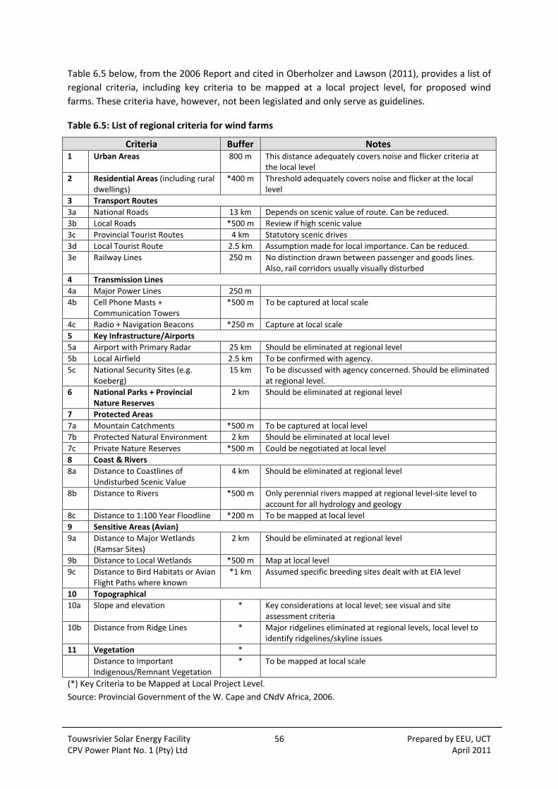
Touwsrivier Solar Energy Facility 56 Prepared by EEU, UCT CPV Power Plant No. 1 (Pty) Ltd April 2011
Table 6.5 below, from the 2006 Report and cited in Oberholzer and Lawson (2011), provides a list of
regional criteria, including key criteria to be mapped at a local project level, for proposed wind
farms. These criteria have, however, not been legislated and only serve as guidelines.
Table 6.5: List of regional criteria for wind farms
Criteria Buffer Notes 1 Urban Areas 800 m This distance adequately covers noise and flicker criteria at
the local level
2 Residential Areas (including rural dwellings)
*400 m Threshold adequately covers noise and flicker at the local level
3 Transport Routes
3a National Roads 13 km Depends on scenic value of route. Can be reduced.
3b Local Roads *500 m Review if high scenic value
3c Provincial Tourist Routes 4 km Statutory scenic drives
3d Local Tourist Route 2.5 km Assumption made for local importance. Can be reduced.
3e Railway Lines 250 m No distinction drawn between passenger and goods lines. Also, rail corridors usually visually disturbed
4 Transmission Lines
4a Major Power Lines 250 m
4b Cell Phone Masts + Communication Towers
*500 m To be captured at local scale
4c Radio + Navigation Beacons *250 m Capture at local scale
5 Key Infrastructure/Airports
5a Airport with Primary Radar 25 km Should be eliminated at regional level
5b Local Airfield 2.5 km To be confirmed with agency.
5c National Security Sites (e.g. Koeberg)
15 km To be discussed with agency concerned. Should be eliminated at regional level.
6 National Parks + Provincial Nature Reserves
2 km Should be eliminated at regional level
7 Protected Areas
7a Mountain Catchments *500 m To be captured at local level
7b Protected Natural Environment 2 km Should be eliminated at local level
7c Private Nature Reserves *500 m Could be negotiated at local level
8 Coast & Rivers
8a Distance to Coastlines of Undisturbed Scenic Value
4 km Should be eliminated at regional level
8b Distance to Rivers *500 m Only perennial rivers mapped at regional level‐site level to account for all hydrology and geology
8c Distance to 1:100 Year Floodline *200 m To be mapped at local level
9 Sensitive Areas (Avian)
9a Distance to Major Wetlands (Ramsar Sites)
2 km Should be eliminated at regional level
9b Distance to Local Wetlands *500 m Map at local level
9c Distance to Bird Habitats or Avian Flight Paths where known
*1 km Assumed specific breeding sites dealt with at EIA level
10 Topographical
10a Slope and elevation * Key considerations at local level; see visual and site assessment criteria
10b Distance from Ridge Lines * Major ridgelines eliminated at regional levels, local level to identify ridgelines/skyline issues
11 Vegetation *
Distance to Important Indigenous/Remnant Vegetation
* To be mapped at local scale
(*) Key Criteria to be Mapped at Local Project Level.
Source: Provincial Government of the W. Cape and CNdV Africa, 2006.
Touwsrivier Solar Energy Facility 57 Prepared by EEU, UCT CPV Power Plant No. 1 (Pty) Ltd April 2011
Relevance to the Project
No formal guidelines have been published for solar energy to assist in the design and assessment of
solar energy development at the local scale. According to Oberholzer and Lawson (2011), through
application of the above guidelines for wind farms as a yardstick, the proposed Project meets the
following criteria:
The facility is not located in an area of high aesthetic landscape value, national parks and provincial nature reserves and other wilderness areas;
The facility is not located in an area where technical and safety considerations apply;
The facility is undergoing an assessment in relation to visual impact, technical and safety criteria and landscape, environmental and planning criteria;
The facility is in a large concentrated solar farm rather than small dispersed locations. The distance between large wind or solar farms is at least 30 km;
Although in a rural area, the site could be described as a “brownfield” site; and
The facility is located in an area where visual disturbance to the landscape has already occurred (e.g. power transmission lines; railway gantries).
Oberholzer and Lawson (2011) have concluded that with reference to Table 6.5 above for wind
farms, the Project meets most of the criteria, except the buffer for national roads. Solar arrays are,
however, a great deal smaller than wind turbines, and therefore a smaller buffer would apply.
6.4 DEVELOPMENTAL AND SPATIAL POLICY
6.4.1 Western Cape Provincial Spatial Development Plan (2009)
The Western Cape Provincial Spatial Development Framework (PSDF) has statutory status. The PSDF
is a long‐term planning instrument, which is to be reviewed every five years. The next revision is due
in 2014. The PSDF, and specifically the objectives and directives contained in it, are aimed precisely
at sustainable development guidance, as applicable to the spatial development situation prevailing
in the Western Cape at present.
Relevance to the Project
Barbour and van der Merwe (2011) have identified the following key objectives of the PSDF with
specific relevance to the proposed Project:
Objective 5: Conserve the sense of place of important landscapes
The PSDF does not specifically address visual and sense of place impacts resulting from solar
facilities, but does address those associated with power lines and wind farms.
The PSDF notes the vital importance of tourism to the Provincial economy. It further notes that
scenic routes (such as the N1) and the adjacent countryside are memorable gateways to Cape Town;
that urban development has already substantially detracted from their visual quality, and that no
further deterioration should therefore be permitted.
The PSDF therefore stipulates that, with regard to the siting and design of future power lines and
other visibly substantial infrastructural development, the relevant provincial guidelines should be
Touwsrivier Solar Energy Facility 58 Prepared by EEU, UCT CPV Power Plant No. 1 (Pty) Ltd April 2011
followed, and proposals should include provision for environmental, visual and heritage impact
assessments.
The following policy directive is of direct relevance to the proposed Project:
Transmission lines
HR26 (…) transmission lines (…) should be aligned along existing and proposed transport corridors
rather than along point to point cross‐country routes. (Mandatory directive)
Of the three grid connection alternatives assessed in the EIA , only two (Option 1a and 1b) would
require additional transmission lines to be constructed, as Option 2 would entail the on‐site direct
linkup with an existing 66 kV transmission line which traverses the site. The Option 1b alignment (±7
km) is proposed to run parallel to an existing 66 kV line and railway infrastructure, and would
therefore conform to the relevant policy directive. Option 1a, the preferred alternative, would not
follow existing transport or transmission line corridors. However, the proposed distance (±5 km) is
shorter, and the proposed alignment is well‐screened from the N1 and other significant receptor
points.
Objective 9: Minimize Consumption of Scarce Environmental Resources
In line with national government’s Climate Change Response Strategy, the PSDF makes provisions for
a strategy based on demand management and the development of renewable resources. The PSDF
proposes that 25% of the Province’s energy generation should ideally consist of renewables by 2020.
In this regard, the Project is envisaged to install 50 MW of renewable energy capacity, and pending
authorisation and licensing, to go online by 2011‐12.
6.4.2 Breede Valley Municipality Integrated Development Plan (2007‐2012)
The 2007‐2011 IDP document represents the second (5‐year) IDP cycle development planning
framework for the Breede Valley Municipality. As set out in Barbour and van der Merwe (2011), the
major developmental issues facing the municipality identified in the IDP are:
High unemployment levels, coupled to the need to create sustainable income‐generating opportunities;
Low skills and education levels;
The spread of HIV/AIDS;
Alcohol abuse and the spread of drug use;
Farm evictions and the subsequent concentration of deracinated, unsuitably skilled and poor people in urban areas; and
The slow pace of land reform.
Relevance to the Project
Job creation and local economic development is a central concept for the Project and it is proposed that the Project could assist with increasing levels of employment and skills development in the Touwsrivier area specifically.
The Draft EMP and the SIA recognise that the spread of HIV/ AIDS and TB, as well as the spread of a drug culture currently pose serious developmental challenges for the area and these aspects can be
Touwsrivier Solar Energy Facility 59 Prepared by EEU, UCT CPV Power Plant No. 1 (Pty) Ltd April 2011
addressed on site in staff training programs in addition to environmental awareness and health and safety training modules (Ecosense, 2011).
6.4.3 The BVM Long Term Growth and Economic Development Strategy (2008)
The BVM Long Term Growth and Economic Development Strategy (LTGEDS) document was adopted
by Council in 2008. In its analysis of the comparative strengths and weaknesses of the BVM, the
document notes that most of the comparative advantages enjoyed by the BVM are linked to its well‐
developed agricultural sector. This makes the BVM vulnerable to a number of problems typically
faced by economies reliant on primary production, including:
• Typically low income levels for workers;
• A low degree of specialisation and associated skills transfers;
• Industries prone to rapid saturation;
• Small scope for associated SMME development; and
• Strong competition faced at local and international levels.
Barbour and van der Merwe (2011) note that the document recommends a strengthening of and
diversification within (e.g. olives, essential oils, biotechnology) the established agricultural sector, as
well as a supplementation/ diversification focusing on emerging sectors. In this regard, tourism‐
development is seen as a feasible economic growth strategy. Key comparative advantages enjoyed
by the region include the variety of landscapes and environments, proximity to Cape Town and the
Boland, and ease of access to all major areas in the BVM via the N1. The document makes specific
reference to the areas eco‐tourism potential.
With regard to Touwsrivier, the Strategy notes that the creation of sustainable local economic
development and employment opportunities should be seen as one of the key priorities of the BVM.
Tourism development and the encouragement of private investment aimed at fostering sustainable
employment creation is identified as potential development strategies. The document further notes
that the town’s location and existing infrastructure provides it with an excellent opportunity for
industrial developments of value‐added activities.
Relevance to the Project
As above, job creation and local economic development is a central concept for the Project and it is
proposed that the Project could assist with increasing levels of employment and skills development
in the Touwsrivier area specifically. These opportunities would be beneficial for the BVM in the long
term. Interviews with key BVM officials have indicated enthusiastic support for the project (Barbour
and van der Merwe, 2011). The only concern is that the Project may result in visual impacts which
may indirectly affect the tourism potential of the area.
6.4.4 The BVM “Broad‐brush” Spatial Development Framework (2006)
Barbour and van der Merwe (2011) have reviewed the current BVM Spatial Development
Framework (SDF) which was approved by Council in 2006. They note that the approved SDF
represents only a “broad‐brush” overall framework. It is understood that a finer‐scaled SDF, based
on bioregional planning principles and associated land use category‐based Spatial Development
Plans, is currently in the process of being compiled for the BVM. However, a draft document was not
Touwsrivier Solar Energy Facility 60 Prepared by EEU, UCT CPV Power Plant No. 1 (Pty) Ltd April 2011
available at the time of undertaking the SIA. The purpose of the fine‐scale mapping exercise would
be to balance the need for conservation with the need for development, being mindful to ensure
ease of access to historically disadvantaged communities. The information below is based on the
2006 SDF document.
According to the SDF, from a spatial perspective the BVM is characterized by its vast expanse of
agricultural land, and the fact that all its major towns are located adjacent or proximate to the N1,
which bisects the BVM from west to east, and acts as a central mobility spine. The historic and
pervasive spatial development pattern in the BMV is characterized by (racially) segregated
communities with greatly differing levels of access to services, facilities, economic opportunities and
basic infrastructure.
The main focus of the SDF is on urban areas. The SDF divides the BVM area into 4 planning areas.
The project study area falls under the Klein Karoo Planning Unit, which includes the town of
Touwsrivier and adjacent rural area east of the Hex River Valley. Application of “broad‐brush” spatial
mapping categories (SDF Figure 5B, p:14) indicate that the proposed Project is located in an area
designated for “extensive agricultural” land use. Figure 5B also indicates that all adjacent land –
essentially all land east of the Hex River Valley, with the exception of Aquila (“Private Nature
Reserve”), Touwsrivier Municipal Nature Reserve (“Local Authority Nature Reserve”) and urban
Touwsrivier (“Urban Related”) – is designated “extensive agricultural”. It seems likely that the finer‐
scaled SDP mapping exercise currently underway may reflect newly established conservation/
tourism‐orientated land uses, which have become established in the area around the site in recent
years.
With regard to Touwsrivier, the document notes that the town is currently struggling economically,
as evidenced by an unemployment rate of around 50%, and notes that “the creation of sustainable
local economic development and job creation opportunities for Touwsrivier must be seen as one of
the priorities of the Breede Valley Municipality” (SDF, p:66). Development of the town and
surrounds into a tourism destination is recommended as a key intervention strategy. Specifically, the
establishment of a steam train museum in the town, and the creation of a steam train route
between the town and De Doorns and beyond, and harnessing the eco‐tourism opportunities
associated with the Aquila Game Reserve and Municipal (Touwsrivier) Nature Reserve are
recommended.
Relevance to the Project
As above, job creation and local economic development is a central concept for the Project and it is
proposed that the Project could assist with increasing levels of employment and skills development
in the Touwsrivier area specifically. The heritage assessment considers the existing railway heritage
of the area and within the site and has confirmed the Project would not conflict with existing railway
resources.

Touwsrivier Solar Energy Facility 61 Prepared by EEU, UCT CPV Power Plant No. 1 (Pty) Ltd April 2011
6.5 ENVIRONMENTAL ASSESSMENT GUIDELINES
6.5.1 National
DEAT has published a series of guidance documents to assist role‐players within the environmental
authorisation process set out in the EIA Regulations (Chapter 5 of NEMA, 2006). This is known as the
Integrated Environmental Management (IEM) Guidelines Series (2002) and the following documents
have been chosen based on their relevancy to guide implementation of this EIA:
Information Series 2: Scoping;
Information Series 3: Stakeholder Engagement;
Information Series 4: Specialist Studies;
Information Series 7: Cumulative Effects Assessment;
Information Series 11: Alternatives in EIA;
Information Series 12: Environment Management Plans;
Information Series 13: Review in EIA; and
Information Series 15: Environment Impact Reporting.
Other DEAT Environmental Management Guidelines (2005) which are more process specific are set
out below and have been referred to where possible:
Guideline 3: General Guide to the EIA Regulations;
Guideline 4: Public Participation;
Guideline 5: Assessment of Alternatives and Impacts; and
Guideline 6: Environmental Management Frameworks.
6.5.2 Provincial
The Western Cape DEA&DP has recently published a set of guidelines which should be taken into
account when undertaking an EIA in line with NEMA. These were published in response to the NEMA
EIA 2010 Regulations and are dated August 2010:
Guideline on Transitional Arrangements;
Guideline on Public Participation;
Guideline on Alternatives;
Guideline on Need and Desirability;
Guideline on Exemptions;
Guideline on Appeals; and
Guideline on Generic Terms of Reference for EAP’s and Project Schedules.

Touwsrivier Solar Energy Facility 62 Prepared by EEU, UCT CPV Power Plant No. 1 (Pty) Ltd April 2011
There are also a number of guidelines published by DEA&DP which particularly relate to specialists
involved in EIAs (2005):
Guideline for Determining the Scope of Specialist Involvement in EIA Processes;
Guideline for the Review of Specialist Input into the EIA Process;
Guideline for Involving Biodiversity Specialists in EIA Processes;
Guideline for Involving Heritage Specialists in EIA Processes;
Guideline for Involving Visual and Aesthetic Specialists in EIA Processes;
Guideline for Involving Economists in EIA Processes;
Guideline for Involving Hydrogeologists in EIA Processes;
Guideline for Environmental Management Plans; and
Guideline for Involving Social Assessment Specialists in EIA Processes.
These guidelines have been applied where necessary in the Scoping and EIA Phases of the
Touwsrivier Solar Energy Facility environmental authorisation process.
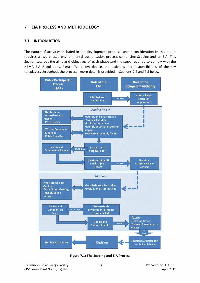
Touwsrivier Solar Energy Facility 63 Prepared by EEU, UCT CPV Power Plant No. 1 (Pty) Ltd April 2011
7 EIA PROCESS AND METHODOLOGY
7.1 INTRODUCTION
The nature of activities included in the development proposal under consideration in this report
requires a two phased environmental authorisation process comprising Scoping and an EIA. This
Section sets out the aims and objectives of each phase and the steps required to comply with the
NEMA EIA Regulations. Figure 7.1 below depicts the activities and responsibilities of the key
roleplayers throughout the process ‐ more detail is provided in Sections 7.2 and 7.3 below.
Figure 7.1: The Scoping and EIA Process

Touwsrivier Solar Energy Facility 64 Prepared by EEU, UCT CPV Power Plant No. 1 (Pty) Ltd April 2011
7.2 SCOPING PHASE
Prior to Scoping, an application was submitted to the DEA including a declaration of interest, written
consent of landowner and application fee on 3 June 2010. Acknowledgement thereof was received
on 10 June 2010. As part of the PPP, the public was notified of the proposed development through a
number of channels (see Section 6.4 below) and the Scoping Phase officially commenced on 1 July
2010.
The aim of the scoping process is to determine the ‘scope’ of the EIA. NEMA Chapter 5(28)(e) states
that following submission of an application, and integrated with the PPP, the EAP must:
Subject the application to scoping by identifying:
i) issues that will be relevant for consideration of the application;
ii) the potential environmental impacts of the proposed activity; and
iii) alternatives to the proposed activity that are feasible and reasonable.
The parties responsible for input into this process include the EAP, the specialist team of
independent consultants and I&APs (persons, organisations or organs of state). The PPP is
fundamental to the environmental authorisation process and the channels through which the I&APs
were involved are outlined below.
7.2.1 Public Participation
DEAT’s Public Participation Guidelines (2005:2) introduce public participation as follows:
“Public participation is one of the most important aspects of the environmental authorisation
process… This stems from the requirement that people have a right to be informed about potential
decisions that may affect them and that they must be afforded an opportunity to influence those
decisions.”
Public participation is an iterative two way process between the applicant and the EAP, and the
I&APs, whether these be individuals, organisations, or organs of state. Within the Scoping Phase the
focus as to ensure that all I&APs have been identified and informed as early on in the process as
possible, to identify issues based on local or expert knowledge of I&APs, to collect information
relating to public needs, values and expectations, and to explore alternatives.
The following channels of communication were used to initiate response from I&APs.
Site Notices
Two site notices, one in English and one in Afrikaans, were attached to the perimeter fence along
the N1 to inform the general public using the area of the proposed activities and the environmental
authorisation process. Appendix 7.1 contains a copy of the information displayed on the notice
boards.
Advertisements
Advertisements have been placed in local, provincial and national newspapers informing the general
public of the proposed activities and the environmental authorisation process (see Appendix 7.2 for

Touwsrivier Solar Energy Facility 65 Prepared by EEU, UCT CPV Power Plant No. 1 (Pty) Ltd April 2011
the content of the advertisements). The details of publication of these advertisements are listed
below:
Worcester Standard, Thursday 1 July 2010, in Afrikaans;
Die Burger, Friday 2 July 2010, in Afrikaans; and
Sunday Times, Sunday 4 July 2010, in English.
Written Notices
Written notices were distributed by post to the following (see Appendix 7.3):
Owners or occupiers of land adjacent to the property (and within 100 m of the boundary) on which the proposed activity is to be sited.
Written notices were distributed by email to the following (see Appendix 7.3):
National Government: DEA; Department of Energy (DoE); Department of Water Affairs (DWA); and South African National Roads Agency Ltd (SANRAL);
Provincial Government of the Western Cape: DEA&DP ; Department of Agriculture and Rural Development; Department of Economic Development & Tourism; Department of Rural Development and Land Reform; and Department of Transport and Public Works;
Cape Winelands District Municipality: EIA Coordinator
Breede Valley Local Municipality: Touwsrivier Area Manager; Planning/Development & Building Control; Spatial & Development Planning, Local Economic Development, Tourism & Sport; Social Development and Human Capital Development; and Councillor for Ward 1;
Tourism organisations: Western Cape; Cape Winelands; and Hex River Valley;
Environmental organisations: Wildlife & Environment Society of SA (WESSA); Botanical Society of SA; Endangered Wildlife Trust; Cape Nature; SANParks; South Africa National Biodiversity Institute (SANBI); Birdlife South Africa;
Other: SAHRA; HWC; Earthlife Africa; Energy Research Centre (ERC, UCT); and
Local tourism operators (various).
The written notices included a copy of the BID which provided all the key information relating to the
proposed development, the process, and the opportunities for involvement.
Background Information Document
The BID is attached in Appendix 7.4. It includes a comment form which encourages I&APs to register
and invites initial responses. The BID was also made available to the general public through deposit
in the Touwsrivier Library, the Worcester Public Library and the Esselen Library (Worcester). The BID
has also been made available on the EEU website.
Public Open Day
A public open day was held at Touwsrivier Primary School on 20 July 2010. Posters were displayed to
provide information on the Project and its proposed location. Persons representing the applicant
and the EAP team were available to provide further information and answer technical or
environmental questions. The aim was to provide the I&APs with an opportunity to query aspects of
the development and to provide comments and responses. BIDs were also made available, as where

Touwsrivier Solar Energy Facility 66 Prepared by EEU, UCT CPV Power Plant No. 1 (Pty) Ltd April 2011
comment sheets. The meeting minutes and attendees are attached as Appendix 7.5.
Landowner Focus Group Meeting
A meeting with four of the six landowners adjacent to the farms on which the Project was held on
Wednesday 1 September 2010 at the Touwsrivier Primary School. This was held during the Draft
Scoping Report review period. The aim was to capture specific concerns regarding the surrounding
land uses and potential impacts, and to gather any local knowledge which would assist with the
assessment. The minutes are attached as Appendix 7.6.
7.2.2 Specialist Studies
Scoping studies were undertaken by the team of specialists which comprised the following:
Geotechnical and Geological – Mike van Wieringen and Associates;
Botanical – Jan Vlok, Regalis Environmental Services;
Faunal – Ken Coetzee;
Social – Tony Barbour and Schalk van der Merwe;
Visual – Bernard Oberholzer and Quinton Lawson; and
Heritage – Tim Hart, UCT Archaeology Contracts Office.
7.2.3 Draft Scoping Report
The Draft Scoping Report (DSR) was subject to review by I&APs for a 30 day period (9 August 2010 ‐
7 September 2010). Comments received were collated within the IRR including the formal responses
issued by the EEU (See Appendix 7.7). The Final Scoping Report (FSR) was submitted to DEA for
approval and received on 10 September 2010. DEA issued a letter of acceptance of the FSR and PoS
on 11 October 2010 with a number of amendments and additional information (see Appendix 1.2).
7.3 EIA PHASE
The EIA Guidelines (DEAT, 2005:11) state that the purpose of the EIA is to:
Address issues that have been raised during the scoping phase;
Assess alternatives to the proposed activity in a comparative manner;
Assess all identified impacts and determine the significance of each impact; and
Formulate mitigation measures.
The EIA Phase has included a number of detailed specialist studies and has provided I&APs with
further opportunities for input. Details are set out below.
7.3.1 Public Participation
A current database of registered I&APs has been compiled and attached as Appendix 2.3. The
database has been updated as further I&APs register with the EAP or provided comments. The
consultation activities are summarised below:

Touwsrivier Solar Energy Facility 67 Prepared by EEU, UCT CPV Power Plant No. 1 (Pty) Ltd April 2011
Meetings
Meetings with the following commenting authorities were held (see Appendix 7.6 for minutes):
Western Cape: DEA&DP (8 November 2010)
Western Cape: Department of Agriculture (8 November 2010)
Department of Water Affairs (12 November 2010)
Eskom Network Planning and Land Management Section (12 November 2010)
Specialist Consultations
As part of the Social Impact Assessment (Appendix 8.5), interviews were undertaken with
landowners adjacent to the site as well as the Breede Valley Local Municipality representatives from
Planning, Local Economic Development, Tourism and the Councillor for the Touwsrivier area. The
appointed planner CNdV has also consulted the local planner on planning issues as part of the
planning approval process. Local knowledge and history of the site has been provided by Jaap
Coetzer to inform the Agricultural Potential Report (Appendix 8.2).
Public Meeting
A public meeting was held at Touwsrivier Primary School on 25 November 2010. Posters were
displayed to provide information on the Project and the findings of the impact assessment. Persons
representing the applicant and the EAP team were available to provide further information and
answer technical or environmental questions. The aim was to provide the I&APs with an opportunity
to query aspects of the development or the assessment process and to provide comments and
responses. The meeting was well attended by members of the local community. Comment sheets
were made available. The meeting minutes and attendees are attached as Appendix 7.5.
Advertisements
Advertisements have been placed in local and provincial and national newspapers informing the
general public of the public meeting and also of the impending comment period for the Draft EIR
(see Appendix 7.2 for the content of the advertisements). The details of publication of these
advertisements are listed below:
Worcester Standard, Thursday 11 November 2010, in Afrikaans;
Die Burger, Thursday 11 November 2010, in Afrikaans; and
Cape Times, Friday 12 November 2010, in English.
Telephonic and Email Communications
Telephonic and/or email communications between the EEU and CapeNature, Civil Aviation Authority
(CAA), South African National Roads Agency Limited (SANRAL) and others have been undertaken and
the parties are aware of their commenting role in the EIA process.
Multi‐stakeholder Meeting
A multi‐stakeholder workshop was planned for early November offering a site visit however a date
could not be found to accommodate all the commenting authorities and hence they were each
approached in person or through telephonic and/or email contact.

Touwsrivier Solar Energy Facility 68 Prepared by EEU, UCT CPV Power Plant No. 1 (Pty) Ltd April 2011
Additional Studies
Through consultation with the Department of Agriculture authorities, an Agricultural Potential
Report (Appendix 8.2) was produced to identify the agricultural potential of the site. In addition, the
heritage specialist recommended that the impacts of the proposed activity on the palaeontological
heritage be addressed in detail through a Palaeontological Impact Assessment (Appendix 8.8). The
additional specialist studies undertaken are as follows:
Palaeontology – John Almond, Natura Viva cc; and
Agriculture – Ken Coetzee, Conservation Management Services.
Media Release
The Engineering News published an article on the status of the EIA on 12 November 2010, see link:
http://www.engineeringnews.co.za/article/eia‐underway‐for‐western‐cape‐50mw‐solar‐park‐2010‐
11‐12
Review of Draft EIR
The Draft EIR was made available to the public for review between 9 March and 8 April 2011 in hard
copy at the Touws River Public Library (Corner of Jane and Logan Street), Steenvliet Library (Dwars
Street) and the Worcester Public Library (Waterloo Street). The report was also available on the EEU
website:
http://www.eeu.org.za/thematic‐areas/environmental‐management‐and‐sustainability/touwsrivier‐
solar‐energy‐facility
The deadline for submission for state authorities as the key commenting authorities was 18 April
2011. All relevant state authorities and registered I&APs were notified of the comment period by
letter and/or email (see Appendix 7.3), and the commenting authorities were sent a CD of the report
and hard copy on request.
Comments received have been included in the IRR (Appendix 7.7) and where relevant have been the
basis for revisions to the Final EIR for issue to the competent authority. Comments were not
received from the Department of Agriculture, Department of Water Affairs and the Civil Aviation
Authority.
7.3.2 Methodology for Assessing Significance
The specialist studies were undertaken in accordance with the Plan of Study set out in the Final
Scoping Report. Generic terms of reference were adhered to and standard significance criteria were
adopted in line with the Regulations. The methodology for assessing the significance of impacts is
largely guided by the DEAT EIA Regulations Guideline Document (DEAT, 1998). The assessment
considers construction, operation and decommissioning both before and after the proposed
mitigation measures have been implemented according to the following criteria:
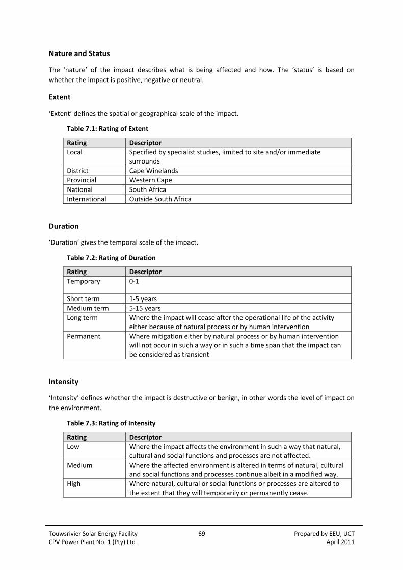
Touwsrivier Solar Energy Facility 69 Prepared by EEU, UCT CPV Power Plant No. 1 (Pty) Ltd April 2011
Nature and Status
The ‘nature’ of the impact describes what is being affected and how. The ‘status’ is based on
whether the impact is positive, negative or neutral.
Extent
‘Extent’ defines the spatial or geographical scale of the impact.
Table 7.1: Rating of Extent
Rating Descriptor
Local Specified by specialist studies, limited to site and/or immediate surrounds
District Cape Winelands
Provincial Western Cape
National South Africa
International Outside South Africa
Duration
‘Duration’ gives the temporal scale of the impact.
Table 7.2: Rating of Duration
Rating Descriptor
Temporary 0‐1
Short term 1‐5 years
Medium term 5‐15 years
Long term Where the impact will cease after the operational life of the activity either because of natural process or by human intervention
Permanent Where mitigation either by natural process or by human intervention will not occur in such a way or in such a time span that the impact can be considered as transient
Intensity
‘Intensity’ defines whether the impact is destructive or benign, in other words the level of impact on
the environment.
Table 7.3: Rating of Intensity
Rating Descriptor
Low Where the impact affects the environment in such a way that natural, cultural and social functions and processes are not affected.
Medium Where the affected environment is altered in terms of natural, cultural and social functions and processes continue albeit in a modified way.
High Where natural, cultural or social functions or processes are altered to the extent that they will temporarily or permanently cease.

Touwsrivier Solar Energy Facility 70 Prepared by EEU, UCT CPV Power Plant No. 1 (Pty) Ltd April 2011
Probability
The ‘probability’ describes the likelihood of the impact actually occurring.
Table 7.4: Rating of Probability
Rating Descriptor
Improbable Where the possibility of the impact materialising is very low either because of design or historic experience.
Probable Where there is a distinct possibility that the impact will occur.
Highly Probable Where it is most likely that the impact will occur.
Definite Where the impact will occur regardless of any prevention measures.
Effect of Significance on Decision‐making
Table 7.5 below will determine whether the significance rating will have an effect on decision‐
making or not.
Table 7.5: Effect of Significance on Decision‐Making
Rating Effect on decision‐making
Low Where it will not have an influence on the decision.
Medium Where it should have an influence on the decision unless it is mitigated.
High Where it would influence the decision regardless of any possible
mitigation.
Mitigation
To avoid or minimise impacts, each of the negative impacts identified includes details of possible
mitigation measures and the degree to which these measures would influence the significance and
status of each impact.
7.3.3 Specialist’s Detailed Methodologies
The detailed methodology for each specialist study is set out below.
Agriculture
The basis for the agricultural study was to establish the agricultural potential of the site to ensure
that the proposed development would not result in the loss of land suitable for agriculture. This was
the requirement of the Provincial Department of Agriculture in reference to the national draft
guidelines for wind energy facilities which was deemed applicable to solar facilities as well. The
outcomes of the assessment were therefore not based on assessing the impacts of the facility itself,
but rather to establish the suitability of the land for activities other than agriculture.
A site visit was previously undertaken by Ken Coetzee in preparation for a fauna impact assessment
of the proposed facility area, so it was not necessary to re‐inspect the site.
The environmental variables of substrate (soil), climate and of water availability were used as a basis
Touwsrivier Solar Energy Facility 71 Prepared by EEU, UCT CPV Power Plant No. 1 (Pty) Ltd April 2011
for the agricultural potential assessment, as well as past and current land uses and the subsequent
impacts thereof.
Geology and Hydrology
A geotechnical report was commissioned outside of the EIA process but with consultation with the
same specialist that was involved in the Scoping Phase and includes construction information
requirements as well as recommendations for identified environmental issues.
A reconnaissance visit to the site had been undertaken on the 30 March 2010. This was followed by
a geological field mapping exercise on the 24 and 25 November 2010 when the salient drainage, soils
and geological features were mapped using a GPS and the satellite image.
The site was revisited on the 1 and 2 December 2010 when trial pits were excavated in the areas
previously identified as being covered by soil and not only rock. Thirty seven trial pits were
excavated using a digger‐loader. These were positioned primarily as a ground‐truthing exercise to
confirm the land facet mapping rather than as an exhaustive sampling exercise as such an
undertaking would have required hundreds of pits. The information from the trial pits was combined
with that from ground profile exposures in the drainage channels and numerous road and rail
cuttings as well as surface outcrops of rock, to compile a detailed data base upon which to develop a
land facet map.
Six soil samples were taken and submitted to the laboratory for testing in order to characterise the
soil types present.
It was intended to conduct light dynamic probes (DPL’s or DCP’s) adjacent to the trial pits where the
soil cover was found to be in excess of 0.5 m thick. In all cases however the probe met with refusal
within 0.5 m of the surface on bedrock or gravel and cobbles or simple very dense silty sand. The
DPL testing was consequently dispensed with.
The report documented the geology, hydrology and drainage, geohydrology, ground profile and
soils, water table and soil profile. This allowed for a number of recommendations to be provided
particularly in relation to the drainage channels, founding conditions, excavation, construction
materials and development considerations.
Botanical
The proposed development area was surveyed on 25 March 2010 to determine if rare and
endangered species and/or plant communities were present and again on and 3 March 2011 to
establish the vegetation along the transmission line options.
The local and regional conservation status of the affected vegetation was investigated following the
principles of de Villiers et al (2005) which set out the Ecosystem Guidelines for Environmental
Assessment in the Western Cape. The vegetation type was identified using the Vegetation Map of
South Africa (Mucina et al, 2005) and the finer scale conservation plan prepared for the Cape
Winelands District Municipality (Skonow et al, 2009) was also consulted to determine whether the
site was within any Critical Biodiversity Areas (CBAs).
Mitigation measures were provided based on the botanical sensitivity of the site in relation to the
nature of the proposed development.
Touwsrivier Solar Energy Facility 72 Prepared by EEU, UCT CPV Power Plant No. 1 (Pty) Ltd April 2011
In terms of potential limitations, all the potential affected areas were surveyed on foot in the field.
This alleviates any potential uncertainty regarding the recommendations of the assessment. The
probability that rare plant species occur within the proposed development areas (solar farm and
transmission line Option 1a) is very slim.
Faunal
The study area was visited on 25 March 2010, together with botanist Jan Vlok, to collect the
biophysical information required for the fauna impact report. A photographic record was also made
of the relevant habitat aspects. Although the transmission line corridors were not visited, Vlok’s
botanical impact assessment (2011) provide the basis for the fauna sensitivity study. Option 1a was
used for this fauna sensitivity study as there is little or no fauna habitat variety between the two
options, except that Option 1b included more of the Succulent Karoo vegetation that is botanically
considered to more sensitive.
In order to determine fauna sensitivity to negative impact, it was necessary, first to determine which
fauna potentially occur on the property. As it was not possible to locate all this fauna during such a
survey, use was made of the published information to determine geographical distribution and the
habitat requirements for all of the vertebrates likely to occur in the general study area and
surrounds. This information was augmented with personal knowledge of the Karoo habitats and the
vertebrates typical in them, as well as a detailed investigation of the study area habitats.
This resulted in vertebrate checklists in which occurrence per species were recorded as either
confirmed, likely, possible or unlikely. From these checklists, the Red Data listed species were
identified and further used to determine overall habitat sensitivity. A list of potential impacts was
then identified in terms of the observations made in the study area and the probability of
occurrence of the Red Data Book listed vertebrate species in the study area. The potential impacts
were then assessed in terms of their severity and significance and mitigatory measures were
proposed.
A habitat model forms the basis for the fauna inventory and entails using a set of habitat
components or attributes to predict some or other characteristic of a wildlife population
(Cooperrider et al, 1986). For this assessment, the method used to determine the presence or
absence of faunal species closely follows the habitat model of Cooperrider et al (1986).
Limitations relate to the predictions of the occurrence of vertebrate fauna by means of the
described method. There is no other way in which to produce accurate occurrence data other than
by means of long term detailed collecting and inventorizing of the fauna on site. Similarly, there is
no more accurate rapid method for verifying the occurrence of the Red Data listed species. The
assumption is that if the habitat is suitable and the geographic range of a particular species
correlates with the study area, then that species is likely to occur. A degree of credibility is given to
these predictions by the extensive personal knowledge of the author of both Karoo habitats and the
fauna that occur in them.
A further limitation is that no final layout information could be provided for the project. The impact
assessment is thus based on the extent of the proposed project depicted in the Faunal Impact
Assessment Report (Appendix 8.4).
Touwsrivier Solar Energy Facility 73 Prepared by EEU, UCT CPV Power Plant No. 1 (Pty) Ltd April 2011
Social
The approach to the Social Impact Assessment (SIA) study is based on the Western Cape Department
of Environmental Affairs and Development Planning Guidelines for Social Impact Assessment
(February, 2007). These guidelines are based on international best practice and have also been
endorsed by DEA. The key activities in the SIA process embodied in the guidelines include:
Describing and obtaining an understanding of the proposed intervention (type, scale, location), the communities likely to be affected and determining the need and scope of the SIA;
Collecting baseline data on the current social environment and historical social trends;
Identifying and collecting data on the Social Impact Assessment variables and social change processes related to the proposed intervention. This requires consultation with affected individuals and communities;
Assessing and documenting the significance of social impacts associated with the proposed intervention;
Identifying alternatives and mitigation measures.
On this basis, the study involved:
Review of demographic data from the 2001 Census Survey and other available sources;
Review of relevant national and provincial energy policy and spatial planning frameworks;
Review of relevant planning and policy frameworks for the Breede Valley (Local) Municipal (BVM) area;
Study area‐specific information collected during site visits to the area and from interviews with key interested and affected parties, including adjacent land owners, community representatives, and representatives of the BVM;
Review of information from similar studies, including the SIA undertaken for the Khi CSP Upington Solar Thermal Plant in the Northern Cape (Barbour and Rogtschnig, 2010);
Literature review of social issues associated with solar energy facilities.
The identification of potential social issues associated with the proposed solar energy facility is
based on observations during the project site visit, review of relevant documentation, experience
with similar projects, and the socio‐economic conditions of the area.
Limitations include the fact that the demographic data used in the study is largely based on the
findings of the 2001 Census , or on sources, which based projections on the Census 2001 data. While
this data does provide useful information on the demographic profile of the affected area, the actual
data is dated and should be treated with care.

Touwsrivier Solar Energy Facility 74 Prepared by EEU, UCT CPV Power Plant No. 1 (Pty) Ltd April 2011
Visual
The methodology used for the VIA included the following steps:
Preparation of a visual baseline report based on a field trip during April 2010, and information provided by the EEU;
Identification of important viewpoints, particularly those relating to the N1 National Road and farmsteads;
Determination of the viewshed, using a digital terrain model (DTM) to determine the area that would be visually affected;
Preparation of photo‐montages using panoramic photographs to determine the degree of visibility of the proposed energy facilities;
Assessment of potential visual impacts, using quantitative criteria, such as visibility and exposure, as well as qualitative criteria such as compatibility and effect on landscape integrity.
Finally, the significance of visual impacts is assessed based on extent, magnitude, duration and probability of the impacts occurring, both before and after mitigation.
The visual assessment involves both qualitative, as well as quantitative criteria, and therefore it is
not easy to establish environmental thresholds for the proposed solar energy facility. Criteria given
in Table 6.5 for wind farms could be used as a general guide. No regional studies or strategic plans
are available at this stage relating to the distribution and siting of solar facilities in the Western
Cape.
The visual assessment criteria include a series of both quantitative and qualitative criteria used to
determine potential visual impacts. These are rated to determine both the expected level and
significance of the visual impacts.
i. Viewpoints
Viewpoints were selected based on prominent viewing positions in the area, where uninterrupted
views of the proposed energy facilities could be obtained.
The proposed facilities would be potentially visible from the N1 National Road, the main rail line and
a number of farms, namely portion 2/37 (Hugo’s Nek) and 6/36 (Grootstraat).
ii. Visibility
Visibility tends to be determined by distance between the proposed energy facilities and the viewer.
Distance radii assist in quantifying visibility of the proposed facilities. Degrees of visibility are in
addition based on the scale of the solar arrays and related infrastructure. Field observations and
photographic panoramas were used as a guide to determining the ratings.
Highly visible: Clearly noticeable within the observer’s viewframe 0 to 1 km
Moderately visible: Recognisable feature within observer’s viewframe 1 to 2.5 km
Marginally visible: Not particularly noticeable within observer’s viewframe 2.5 to 5 km
Hardly visible: Practically not visible unless pointed out to observer 5 km+

Touwsrivier Solar Energy Facility 75 Prepared by EEU, UCT CPV Power Plant No. 1 (Pty) Ltd April 2011
iii. Visual Exposure
Visual exposure is determined by the 'viewshed' or 'view catchment', being the geographic area
within which the project would be visible. The viewshed boundary tends to follow ridgelines and
high points in the landscape. Some areas within the view catchment area fall within a view shadow,
and would therefore not be affected by the proposed energy facilities. The zone of visual influence
tends to fade out beyond 5 km distance.
iv. Visual Sensitivity
Visual sensitivity is determined by topographic features, steep slopes, protected areas, scenic routes,
private nature reserves and guest farms.
v. Landscape Integrity
Visual quality is enhanced by intactness of the landscape, and lack of other visual intrusions. The site
and its surroundings have existing rail lines with pylons, Eskom transmission lines, a substation and
old spoil heaps, and the area is therefore not pristine.
vi. Visual Absorption Capacity
This is the potential to screen the project. Given the scale of the proposed facilities and the open
nature of the landscape, there is little opportunity for screening, except perhaps along the N1 Route
itself.
vii. Potential Visual Impact
When the criteria above are considered in combination, an indication of the potential visual impacts
can be determined, together with an indication of mitigation measures required.
Limitations to the VIA are that the layouts and size of the various energy facilities are only indicative
at this stage, and are subject to change in the detailed design phase. No detailed layouts or
information on the siting of the solar arrays, access roads and building finishes and colours, as well
as lighting were available during the visual assessment, and assumptions had to be made regarding
these elements. Similarly, no information on the size and nature of the construction camp and
equipment, or the location of borrow pits was available. However, adequate information on
prototypes was available to simulate the general scale of the project for the photomontages.
Heritage
The heritage study assesses the identified range of impacts in terms of accumulated knowledge of
the area. The source of information that is used for this process is based on scientific and other
publications related to archaeological work undertaken in the Touwsrivier area and other
unpublished reports on the history of the region. A survey of heritage resources has been
conducted on site and heritage indicators (conservation‐worthy buildings, archaeological sites and
places celebrated as heritage) identified and mapped where appropriate. Definitions of heritage and
criteria for assessment of heritage are indicated in the National Heritage Resources Act while the
Provincial Guidelines for assessing heritage in the Western Cape applies (Baumann and Winter
2005). Both the NHRA and Provincial Guidelines require that cultural landscapes and areas of
particular aesthetic and/or cultural heritage significance are included in the assessment.

Touwsrivier Solar Energy Facility 76 Prepared by EEU, UCT CPV Power Plant No. 1 (Pty) Ltd April 2011
The study reported on here has been significantly reliant on a physical survey of the study area and
the body of background information (published and unpublished) about the area. An independent
visual assessment forms part of the EIA specialist studies.
Routes for alternative transmission lines have not been surveyed but are evaluated in terms of
known information. Final route walk‐downs would need to take place once a preferred option has
been identified.
Data collection took place mainly during the physical site inspection on 30 March 2010 and on 2
November 2010. The proposed location of the trackers was inspected on foot and every accessible
track was driven with an off‐road vehicle.
Places and objects of heritage significance (structures, archaeological material) were examined and
evaluated. No archaeological or historical material was removed from the study area, but recorded
and photographed in situ. The landscape around the site perimeter was examined to get a sense of
the way in which any scenic and heritage rich areas would respond to the presence of the proposed
facility.
Data analysis involves mainly the assessment of the spatial distribution of archaeological
occurrences on the landscape to determine which areas held the highest potential for heritage
material. The analysis of archaeological material on individual sites is based upon the experience of
the team members who are familiar with the current standard classification systems for artefactual
material which enables them to roughly date and characterise an archaeological site or set of
artefacts. Built environment is considered in terms of the grading system for structures that is
presently employed by a number of SAHRA offices and some provincial compliance offices.
Palaeontology
The palaeontological impact assessment (PIA) provides an evaluation of the observed or inferred
palaeontological heritage within the study area, with recommendations for specialist
palaeontological mitigation where this is considered necessary. The study is based on (1) a review of
the relevant scientific literature, (2) published geological maps and accompanying sheet
explanations, (3) a one‐day field scoping study (5‐6 January 2011) as well as (4) the author’s
extensive field experience with the formations concerned and their palaeontological heritage.
In preparing a palaeontological desktop study the potentially fossiliferous rock units (groups,
formations etc) represented within the study area are determined from geological maps. The known
fossil heritage within each rock unit is inventoried from the published scientific literature, previous
palaeontological impact studies in the same region, and the author’s field experience. This data is
then used to assess the palaeontological sensitivity of each rock unit to development (Provisional
tabulations of palaeontological sensitivity of all formations in the Western, Eastern and Northern
Cape have already been compiled by J. Almond and colleagues; e.g. Almond and Pether 2008). The
likely impact of the proposed development on local fossil heritage is then determined on the basis of
(1) the palaeontological sensitivity of the rock units concerned and (2) the nature and scale of the
development itself, most notably the extent of fresh bedrock excavation envisaged. When rock units
of moderate to high palaeontological sensitivity are present within the development footprint, a
preliminary field‐based assessment by a professional palaeontologist is usually warranted.
The focus of the preliminary field‐based palaeontological assessment work is not simply to survey
the development footprint or even the development area as a whole (e.g. farms or other parcels of

Touwsrivier Solar Energy Facility 77 Prepared by EEU, UCT CPV Power Plant No. 1 (Pty) Ltd April 2011
land concerned in the development). Rather, the palaeontologist seeks to assess or predict the
diversity, density and distribution of fossils within and beneath the study area, as well as their
heritage or scientific interest. This is primarily achieved through a careful field examination of one
or more representative exposures of all the sedimentary rock units present (N.B. Metamorphic and
igneous rocks rarely contain fossils). The best rock exposures are generally those that are easily
accessible, extensive, fresh (i.e. unweathered) and include a large fraction of the stratigraphic unit
concerned (e.g. formation). These exposures may be natural or artificial and include, for example,
rocky outcrops in stream or river banks, cliffs, quarries, dams, dongas, open building excavations or
road and railway cuttings. Uncemented superficial deposits, such as alluvium, scree or wind‐blown
sands, may occasionally contain fossils and should also be included in the scoping study where they
are well‐represented in the study area. It is normal practice for impact palaeontologists to collect
representative, well‐localized (e.g. GPS and stratigraphic data) samples of fossil material during field
assessment studies. All fossil material collected must be properly curated within an approved
repository (usually a museum or university collection).
Note that while fossil localities recorded during fieldwork within the study area itself are obviously
highly relevant, most fossil heritage here is embedded within rocks beneath the land surface or
obscured by surface deposits (soil, alluvium etc) and by vegetation cover. In many cases where levels
of fresh (i.e. unweathered) bedrock exposure are low, the hidden fossil resources have to be inferred
from palaeontological observations made from better exposures of the same formations elsewhere
in the region but outside the immediate study area. Therefore a palaeontologist might reasonably
spend far more time examining road cuts and borrow pits close to, but outside, the study area than
within the study area itself. Field data from localities even further afield (e.g. an adjacent province)
may also be adduced to build up a realistic picture of the likely fossil heritage within the study area.
On the basis of the desktop and preliminary field assessment studies, the likely impact of the
proposed development on local fossil heritage and any need for specialist mitigation are then
determined. Adverse palaeontological impacts normally occur during the construction rather than
the operational or decommissioning phase. Mitigation by a professional palaeontologist – normally
involving the recording and sampling of fossil material and associated geological information (e.g.
sedimentological data) – is usually most effective during the construction phase once fresh
fossiliferous bedrock has been exposed by excavations. To carry out mitigation, the palaeontologist
involved would need to apply for a palaeontological collection permit from the relevant heritage
management authority (e.g. SAHRA for the Northern and Eastern Cape, Heritage Western Cape for
the Western Cape). It should be emphasized that, providing appropriate mitigation is carried out, the
majority of developments involving bedrock excavation can make a positive contribution to our
understanding of local palaeontological heritage.

Touwsrivier Solar Energy Facility 78 Prepared by EEU, UCT CPV Power Plant No. 1 (Pty) Ltd April 2011

Touwsrivier Solar Energy Facility 79 Prepared by EEU, UCT CPV Power Plant No. 1 (Pty) Ltd April 2011
8 DESCRIPTION OF THE BASELINE ENVIRONMENT
8.1 INTRODUCTION
This Section aims to provide a profile of the existing environment relating to the proposed
development which has provided the context for the Scoping Study, as well as a baseline from which
to identify environmental issues and potential impacts.
The administrative, land use, physical, ecological and socio‐economic environmental conditions are
described and have been collated using various desk based sources, a site visit on 30 March 2010
and 11 February 2011 and the information documented within the specialist studies.
8.2 GEOGRAPHICAL AND ADMINISTRATIVE CONTEXT
The proposed site for the Touwsrivier Solar Energy Facility is located approximately 12 km south‐
west of the town of Touwsrivier (see Appendix 1.3 for regional mapping) and falls within the eastern
portion of the Breede Valley Municipality (BVM), Western Cape. The BVM is a Category B
Municipality and essentially a rural municipality. The administrative seat of the BVM is in the town of
Worcester, which is the only large town. Smaller towns and settlements include Touwsrivier, De
Doorns, Rawsonville, Goudini and Kwaggaskloof. The BVM is divided into 20 wards and the study
area is located within Ward 1 (‘Touwsrivier’).
At a district level, the site is one of five constituent B‐Municipalities falling under the jurisdiction of
the Cape Winelands District Municipality (CWDM). The others are Witzenberg, Drakenstein,
Stellenbosch, and Breede River/Winelands Local Municipalities. The role of the CWDM is to
administer and make rules for the district, thereby sharing local government duties to ensure
integrated development planning and equitable distribution of resources and services. The
boundaries of the CWDM roughly align with the area known historically as the ‘Boland’, and the site
itself is located near the western edge of the arid Great Karoo.
8.3 LAND USE AND OWNERSHIP
The total site footprint is approximately 215 ha and lies within portions of two different farms:
Hartebeeskraal (1/36) and Ratelbosch (4/149). The land required for the site is owned by the
Abundance Trust, represented by Mr Searle Derman. The land required for Grid Connection Option
1a also falls on Hartebeeskraal (1/36), whilst the land for Option 1b falls on land owned by Hans
Heyvenrych (Farm 740) and Casper Wolff (Farm RE/34).
The N1 National Road lies to the north of the site and the existing Trans‐Karoo main railway line
borders the site to the north. The Karoo Transnet substation is located on the site which provides
electricity to the railway line from the 66 kV Eskom overhead transmission line passing across the
site. The decommissioned alignment of the historic 1830 Hex River Railway Pass traverses the site,
whilst the 1930 alignment is outside the site perimeter to the south (see Figure 1.2).
The current land use zoning is Agriculture and the history of the site and its current agricultural
potential is described in Section 8.5 below. There is some vegetation of conservation value on the
periphery of the site as described in Section 8.6 below.

Touwsrivier Solar Energy Facility 80 Prepared by EEU, UCT CPV Power Plant No. 1 (Pty) Ltd April 2011
8.4 PHYSICAL ENVIRONMENT
8.4.1 Topography
The wider landscape is characterised by relatively flat terrain interrupted by subtle hills or ridges and
koppies.
The natural, undisturbed parts of the site are characterised by moderately steep and stony
vegetated slopes, some of which become rocky in places. A minor seasonal ‘forked’ drainage line
cuts across the western half of the area, ‘flowing’ from south to north – this drainage line was
severely flooded a few years ago and erosion caused by this event is evident. Much of the drainage
line is eroded due to the close proximity of the ploughed area and channelisation in disturbed areas
(compare Plate 8.1 and Plate 8.2). In the east, the study area lies along the lower pediment slopes of
a larger rocky ridge. For the rest, the area is relatively flat. The decommissioned former railway
alignment has resulted in a raised stone embankment all along the southern part of the study area,
providing artificial rocky habitat for certain less sensitive and ubiquitous plant species.
Plate 8.1: The relatively intact seasonal drainage line that cuts across the transformed part of the study area.
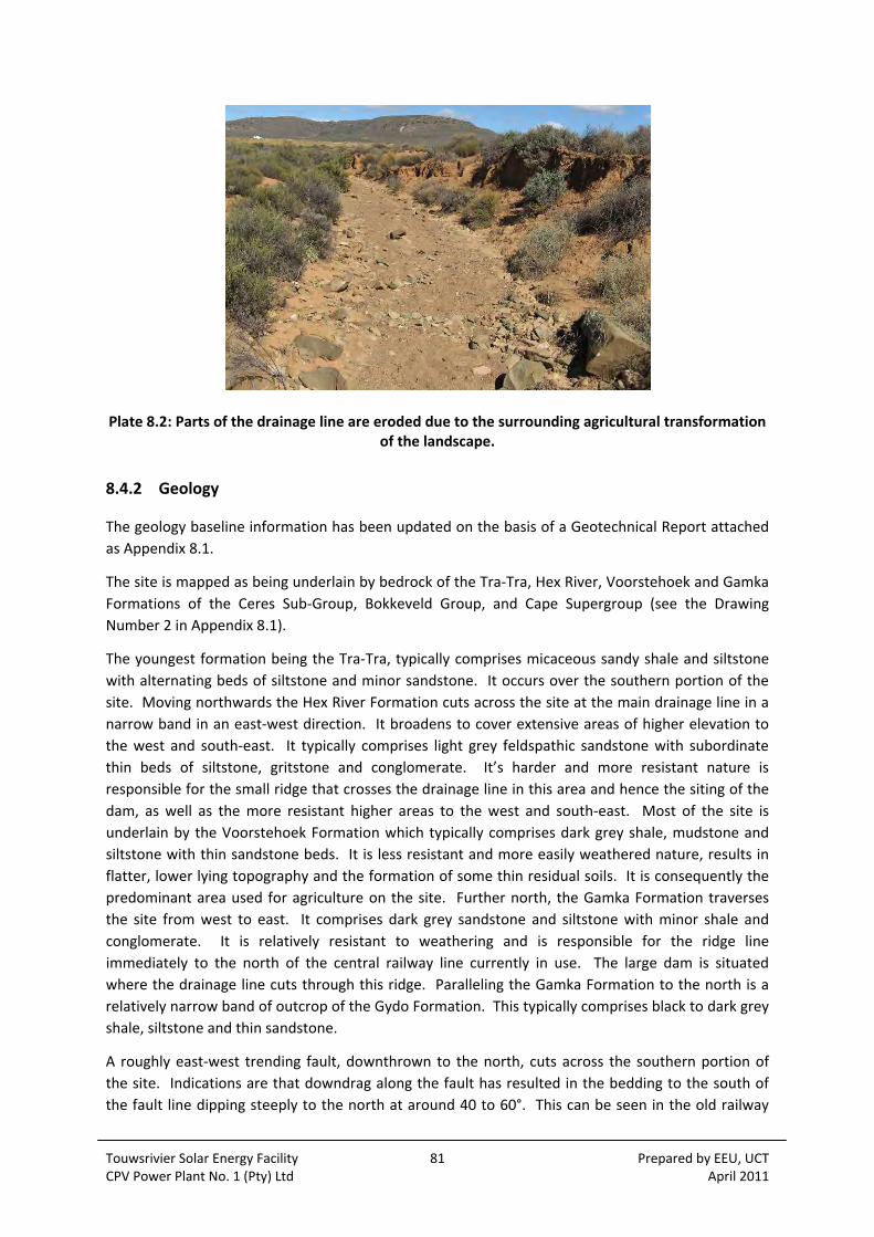
Touwsrivier Solar Energy Facility 81 Prepared by EEU, UCT CPV Power Plant No. 1 (Pty) Ltd April 2011
Plate 8.2: Parts of the drainage line are eroded due to the surrounding agricultural transformation of the landscape.
8.4.2 Geology
The geology baseline information has been updated on the basis of a Geotechnical Report attached
as Appendix 8.1.
The site is mapped as being underlain by bedrock of the Tra‐Tra, Hex River, Voorstehoek and Gamka
Formations of the Ceres Sub‐Group, Bokkeveld Group, and Cape Supergroup (see the Drawing
Number 2 in Appendix 8.1).
The youngest formation being the Tra‐Tra, typically comprises micaceous sandy shale and siltstone
with alternating beds of siltstone and minor sandstone. It occurs over the southern portion of the
site. Moving northwards the Hex River Formation cuts across the site at the main drainage line in a
narrow band in an east‐west direction. It broadens to cover extensive areas of higher elevation to
the west and south‐east. It typically comprises light grey feldspathic sandstone with subordinate
thin beds of siltstone, gritstone and conglomerate. It’s harder and more resistant nature is
responsible for the small ridge that crosses the drainage line in this area and hence the siting of the
dam, as well as the more resistant higher areas to the west and south‐east. Most of the site is
underlain by the Voorstehoek Formation which typically comprises dark grey shale, mudstone and
siltstone with thin sandstone beds. It is less resistant and more easily weathered nature, results in
flatter, lower lying topography and the formation of some thin residual soils. It is consequently the
predominant area used for agriculture on the site. Further north, the Gamka Formation traverses
the site from west to east. It comprises dark grey sandstone and siltstone with minor shale and
conglomerate. It is relatively resistant to weathering and is responsible for the ridge line
immediately to the north of the central railway line currently in use. The large dam is situated
where the drainage line cuts through this ridge. Paralleling the Gamka Formation to the north is a
relatively narrow band of outcrop of the Gydo Formation. This typically comprises black to dark grey
shale, siltstone and thin sandstone.
A roughly east‐west trending fault, downthrown to the north, cuts across the southern portion of
the site. Indications are that downdrag along the fault has resulted in the bedding to the south of
the fault line dipping steeply to the north at around 40 to 60°. This can be seen in the old railway

Touwsrivier Solar Energy Facility 82 Prepared by EEU, UCT CPV Power Plant No. 1 (Pty) Ltd April 2011
cutting where the fault cuts across the cutting. Indications are that the faulting is accompanied by
calcretization of the bedrock.
Over the rest of the site, the bedding dips to the south and south‐east at 10 to 25° on average
steepening in the area of the tunnel portal in the north‐west to as much as 42°.
A significant magnetic anomaly is mapped as traversing the site from north‐west to south‐east.
The bedrock is visible on the surface as outcrops over large areas and in the stream beds and railway
cuttings, but is otherwise covered by a thin layer of residual soil and transported soils and gravels.
8.4.3 Hydrology and Drainage
The hydrology and drainage baseline information has been updated on the basis of a Geotechnical
Report attached as Appendix 8.1.
A single main drainage line with lesser tributaries cuts across the site from south‐west to north‐east.
Its catchment area beyond the site perimeter to the south‐west is significantly large.
The old railway line to the south‐west, south and south‐east of the site effectively forms a cut‐off
drain that diverts water draining northwards to particular points of entry onto the site in the form of
culverts beneath the railway. In a similar fashion, the current railway line to the north and the old
railway line even further north, which both cut across the site from east to west, both restrict
drainage off the site to culverts beneath these two railway lines.
The locations of these culverts and their opening sizes where recorded, are shown in Appendix 8.1
(on the appended site plan Drawing Number 2). These sizes are current opening sizes where the
floor of the culvert is often silted up to well above invert level.
The drainage channels crossing the area between the southern and the central railway lines were
mapped using a GPS. Elsewhere they are interpreted from the satellite image. These are all shown
on Drawing Number 2 in Appendix 8.1.
Two large dams exist on the site, one in the centre‐north and one in the north‐west corner. These
two are connected by a drain such that water from the latter can be diverted into the former. Four
other smaller dams exist; two in the north‐east and two towards the centre of the site with a further
three very small dams or retention ponds sited where culverts beneath the southernmost old
railway line discharge onto the site.
Ridges of hard sandstone with adjacent bands of less permeable shale tend to strike east‐west
across the site which tends to bring water to the surface at the points where the drainage lines cross
the ridges. These positions therefore correspond to the preferred dam sites.
All natural water flows across the site are ephemeral; there being none at the time of the survey
although water pumped from boreholes was being fed into some of the channels. The run‐off
coefficient of the area is high which, coupled with the large catchment areas, leads to large scale
flash flooding at times. There is little evidence to suggest that any of the dams have over‐topped in
recent times however.
A significant feature of all of the drainage channels on the site, except for a very short distance in the
south‐west corner and the short tributary entering from the west immediately to the south of the
tunnel spoil heaps, is that they have all been re‐aligned and straightened by digging trenches. Some
Touwsrivier Solar Energy Facility 83 Prepared by EEU, UCT CPV Power Plant No. 1 (Pty) Ltd April 2011
of these trenches have started to meander in the central area to adopt the appearance of a more
natural stream line but they still do not follow the original natural stream line. These trenches and
the original stream line are shown in Appendix 8.1 (Drawing Number 2) along with areas where
different types of bedrock were visible in the floor.
The drainage lines are mostly eroded or cut down to bedrock with bedrock being exposed in the
floor over significant distances or at salient points where more resistant sandstone and siltstone
bands cut across the channels. Erosion by downcutting is therefore slow and not significant. Sides
are near vertical with lateral erosion on the outside of bends being significant. This tends to result in
a box‐shaped cross‐section the width and depth of which was recorded over most of the lengths of
the channels between the southernmost two railway lines. Width and depth tends to increase
downstream with the maximum recorded being some 25 m wide and 1.8 m deep.
8.4.4 Geohydrology
The geohydrology baseline information has been updated on the basis of a Geotechnical Report
attached as Appendix 8.1.
The southwards dip of the alternating sandstone and shale beds with the less permeable shales
acting as aquitards makes the sandstones beneath the shales preferred targets for groundwater,
particularly in the vicinity of the fault line or magnetic anomaly.
Six boreholes were noticed on site and their positions are shown in Figure 1.2 and Appendix 8.1 (on
the plan Drawing Number 2). One is slightly beyond the southern railway line and is currently being
utilised to supply water to the dams downstream and thence for irrigation.
Details of the boreholes are unknown but they are reputed to typically be approximately 100 m deep
with yields of the order of 60,000 litres/hour.
Groundwater quality tests have not been conducted. A single test on a sample from the
southernmost borehole reportedly indicated a “salt concentration of 700 ppm.” It has proved to be
drinkable on site and it is therefore expected to be suitable for concrete mixing but might require
filtration for purposes of washing solar panels and drinking. Detailed water sampling and testing will
be undertaken prior to construction.
8.4.5 Ground Profile and Soils
The ground profile and soils baseline information has been updated on the basis of a Geotechnical
Report attached as Appendix 8.1.
Soils are generally thin with the maximum thickness recorded on the site being 2.0 m underlain by
bedrock. The transported surficial soils comprise silty sands grading downwards into slightly clayey
sandy silts and often resting on or containing, sub‐rounded gravels, cobbles and occasional small
boulders at the base. Sub‐rounded sandstone and siltstone cobbles and pebbles tend to lie
scattered over the surface on the lower slopes below the areas of harder rock outcrop.
The residual soils underlying the transported ones are thin and ‘skeletal’ being weathered shale in
the form of silty, sandy gravels rapidly grading into gravels of shale fragments and ultimately very
soft rock shale. Cementation by calcretization of the transported and residual gravels is to be found
in certain scattered areas.

Touwsrivier Solar Energy Facility 84 Prepared by EEU, UCT CPV Power Plant No. 1 (Pty) Ltd April 2011
Except possibly for the uppermost 0.3 m, the consistency of the soils is very dense. If saturated
however, it is likely that a less competent consistency would result. The trial pit profiles depicting
the various soil and bedrock types are provided in Appendix 8.1 (Figure Number 1).
8.4.6 Water Table
During the geotechnical investigation, no water table was encountered in any of the trial holes
excavated on the site nor was there any evidence of one in the railroad cuttings. The permanent
water table is therefore expected to be relatively deep and to reside in the bedrock. The boreholes
on the site have not been plumbed but would reveal the depth of the water table.
After extended, extremely wet weather, it is likely that a perched water table would develop within
the colluvial soils and gravels on the underlying bedrock. It would not be expected to persist for any
great length of time however.
8.4.7 Climate
The study area is located in the Western Cape and has a Mediterranean Climate, receiving more of
its rainfall during winter. However, the study area is located near the western edge of the Great
Karoo which is typically arid. The mean annual precipitation for the area is between 150 ‐ 470 mm,
with an average of 300 mm, which peaks in late winter (July to August) (Mucina and Rutherford
(2006) in Appendix 8.2. The area is subject to seasonal drought, but the most influential climatic
factor is undoubtedly temperature. The mean daily maximum is 27.4°C. Frequent high daily
temperatures with relatively low rainfall on aridified soil result in extreme evaporative potential,
2,014 mm and with a mean rainfall of only 300 mm.
The mean annual moisture stress (which is the percentage of days of the year when the evaporative
demand is more than double the soil moisture supply) is a full 76%. This means that for 285 days of
the year, the evaporation is more than double the available soil moisture.
8.5 AGRICULTURAL POTENTIAL
An Agricultural Potential Assessment (Coetzee, 2011) has been undertaken and is attached as
Appendix 8.5. The aim of this assessment was to provide a history of the agricultural activity on the
site as well as to provide an evaluation of the current agricultural potential to address the potential
loss of agricultural land.
8.5.1 Land Use History
The area of formerly cultivated lands is shown in Figure 8.1 below. This comprises lands cultivated
under irrigation as well as for dry‐land cultivation. The lands were first cleared for cultivation in the
1940’s or 1950’s and were used to cultivate dry‐land grain crops, mainly wheat and oats. The success
of these efforts is not known.
Productive lands north of the N2 highway are still cultivated under irrigation to provide
supplementary feed for the Aquila Game Reserve. A small land south of the N2 is still currently used
to grow lucern under irrigation. These farming activities are presently being managed by Mr J
Coetzer, who was able to provide history of cultivation in the area and other local knowledge.

Touwsrivier Solar Energy Facility 85 Prepared by EEU, UCT CPV Power Plant No. 1 (Pty) Ltd April 2011
In time, it was found that the dry‐land cultivation of the lowlands in the general area (Touwsrivier)
was not profitable. At best, a yield of between 0.8 ton/ha and 1.2 ton/ha could be achieved (pers
comm, Coetzer, 2011). The study area specifically produced even less, making it not even worth the
effort to harvest the crop, its only use then being for livestock grazing.
Figure 8.1: Habitats and habitat sensitivity of the study area (The green area represents the former cultivated lands)
As a result of poor yields, dry‐land cultivation was discontinued in the district and the local Co‐
operative is no longer geared to receive such produce (pers comm, Coetzer, 2011).
In 2009, the then landowner, a Mr J Vermeulen, cleared the extreme western land for the first time
(it was virgin veld) and planted oats. This effort was also a failure and the cultivation of the land was
also discontinued (pers comm, Coetzer, 2011).
Since 1990, the bulk of the lands have not been successfully cultivated. In 1991, a scheme under the
auspices of the Department of Agriculture, to rehabilitated marginal old lands with Oumansoutbos
(Atriplex nummularia) for livestock grazing was initiated. The fodder crop was not successful with
only a 50% establishment rate and the project was abandoned (pers comm, Coetzer, 2011).
During the last (20) years the lack of continued cultivation, coupled with other negative land‐use
practices (eg: Drainage channelling, overgrazing, rampant soil erosion) have had a further negative
impact on the former lands, degrading them still further as will be described in the next section.

Touwsrivier Solar Energy Facility 86 Prepared by EEU, UCT CPV Power Plant No. 1 (Pty) Ltd April 2011
8.5.2 Description of the Physical Environment and its Constraints
Soil
The soils are generally shallow with underlying shale bedrock, usually no deeper than 1, but in many
areas even shallower (van Wieringen, 2011). The study site is underlain by the Voorstehoek
Formation of the Bokkeveld Group and consists most of dark grey shale, mudstone, siltstone and
thin sandstone (Toerien, 1979). The soils that weather out from these rocks are generally silty,
sandy, gravely and with a relatively high clay content of 28% (van Wieringen, 2011). Along the
drainages, the soils are somewhat deeper, consisting of alluvium which is made up out of the fine silt
and gravels that were deposited by water.
The soils are thus fine and silty with a high clay content. The soil organic component is very weak,
resulting in fine silty material which compacts to form a dense, impervious, sealed crust when
compacted and wet. Field inspection revealed that the soil surface has little or no organic mulch
layer over the surface and as a result is vulnerable to wind and water erosion and extreme
desiccation (see description of climate below).
According to Ellis and Lambrechts (1986), the a‐horizons of the soils of the general area are relatively
rich in most plant nutrients. The topsoil of the study area, despite the availability of most plant
nutrients has, however, become degraded through repeated dry‐land cultivation with little or no
organic input back into the soil.
The almost complete lack of organic material in the fine silty soil plus the fine clay‐like composition
and the tendency to compact explains why dry‐land cultivation was not profitable. With very low
yields and ecologically unwise cultivation methods, soil organic material continued to decrease as
the years went by, resulting in the aridified conditions prevailing today.
Climate
Climate is described in Section 8.4.7 above and referenced from Mucina and Rutherford (2006) in
Coetzee (2011). In summary, the area is characterised by seasonal drought with a mean daily
temperature of 27.4°C and mean annual average precipitation being 300 mm. The mean annual
moisture stress is a full 76% meaning that for 285 days of the year, the evaporation is more than
double the available soil moisture.
These are very inhospitable conditions for dry‐land cultivation and it is no wonder that it is no longer
widely practised in the general area.
Hydrology and Water Availability
The hydrology and drainage across the study area is described in the Geotechnical Report, and
Section 8.4.3 above. To summarise, the railway line on the southern edge of the study area diverts
all northward‐flowing drainage through two culverts under the rail line embankment.
The drainage runoff then flows into two transformed drainages. These drainage lines have been
realigned to divert water more directly into 2 large dams. The earth moving disturbance was never
rehabilitated and the banks of the drainages have become eroded by variably deep gulley systems
along the banks on both sides of each drainage. Seasonal flash flooding contributes to the
accelerated erosion of the unprotected drainage line banks.

Touwsrivier Solar Energy Facility 87 Prepared by EEU, UCT CPV Power Plant No. 1 (Pty) Ltd April 2011
The result of this soil exposure in these eroded box‐shaped gulley systems is aridification. The
moisture retention capability of the soils along the drainages has been lost due to increased soil
exposure and the already described effects of evaporation. This aridification affects the area on both
sides of each of the drainages, further reducing the productive potential of the old lands.
This aridification has resulted in the loss, or severe reduction, of topsoil micro‐organisms such as
michorrhizae and soil fauna that are essential components of fertile topsoil. The loss of the soil
organisms further reduces the potential for soil to assimilate organic material, a situation further
exacerbated by exposure, high soil temperature and consequent evaporation.
The boreholes within the site have been described and mapped as part of Section 8.4.4 above, only
one is currently being used for irrigation downstream and is assumed to be the only “productive”
water supply. This borehole is approximately 100 m deep and yields approximately 60,000
litres/hour. If this borehole is pumped for only 5 hours, at 60,000 litres/hour, a total of 300,000 litres
would be drawn off the water table. The drawdown caused by water extraction would certainly also
impact on the overall soil moisture content and by employing any of the other boreholes for
irrigation, the drawdown of the water table would be unsustainable in the long term and would have
a negative environmental impact on both the lands, as well as the surrounding natural veld.
It is thus unlikely that the irrigation of the cultivated lands of the study area would be possible from
boreholes without a long term negative environmental impact.
As documented in the Geotechnical Report (Appendix 8.1 and Section 8.4.6) the permanent water
table is very deep below the study area and to “reside within the bedrock”. Significant drawdown for
irrigation water extraction would thus significantly contribute to the general lowering of the water
table and the aridification of the study area.
Even if the water was available for irrigation, it has been shown that the replenishing rainfall is low
and, coupled with a high evaporative rate that is double the soil moisture content, would make
irrigation environmentally unsustainable on the study area.
8.5.3 The Potential for Productive Agricultural Development
The cultivation of the lands on the study area has proved to be unproductive in the past. This was
the situation under dry‐land cultivation. The potential to extract groundwater for the additional
irrigated cultivation of the lands would have severe negative environmental implications for the
lands and the surrounding natural veld.
Unwise land management has led to the severe disturbance of the drainages, effectively turning
them into desiccated donga systems with the severe aridification of the soils adjacent to the
drainages. This aridification is extended throughout the lands due to unsuccessful dry‐land
cultivation, soil compaction, soil exposure and the loss of soil micro‐organisms. Organic material is
lost to the soil which compacts and forms an impermeable soil crust that increases runoff and
decreases infiltration. This all contributes to minimal replenishment of the water table.
The evaporative demand on the soil is more than double the soil moisture supply and the mean of
300 mm rainfall is unable to adequately replenish this moisture loss.
Successful cultivation and production on the lands would require the application of vast quantities of
organic material and the inoculation of the soil with michorrhizae before productivity can be
achieved. So much remediation would be required that it would be prohibitively expensive. This

Touwsrivier Solar Energy Facility 88 Prepared by EEU, UCT CPV Power Plant No. 1 (Pty) Ltd April 2011
process would also not occur overnight, as the very structure of the topsoil must be modified to
combat the effects of aridification and soil micro‐organism loss. In addition to this, water
management berms (contours) would have to be constructed to avoid the use of the lands
contributing further to the existing soil erosion.
To then be productive, the lands would have to be sustainably irrigated and must produce sufficient
excess organic material to plough back in order to maintain a suitable level of soil organic material.
Sufficient water for the level of irrigation required is simply not available and the extraction of it
would have a severe negative environmental impact on the general area, particularly the
surrounding natural vegetation.
Dry‐land cultivation has proved to be unproductive, so much so that the Touws River Co‐op no
longer promotes or supports the potential from dry‐land cultivation.
8.5.4 Cultivation
It is concluded that the former cultivated lands of the study area are no longer economically
productive and that their productive potential was probably originally overestimated.
Both the extremes of the climate and the nature of the substrate make the further agricultural
cultivation of the area unwise and difficult to justify financially. Even rehabilitation under the expert
guidance of the Department of Agriculture was not successful.
Water extraction for cultivation would have a negative impact on the general area, and would only
result in the further aridification of the land.
It is therefore recommended that the former cultivated lands of the study area should not be used
for agricultural production and that the disturbed areas can be made available for some other type
of land use.
8.6 BOTANY
The botanical baseline information has been sourced from the Botanical Scoping Study (Vlok, 2010)
and the Botanical Impact Assessment (Vlok, 2011) attached as Appendix 8.3.
8.6.1 Regional Conservation Status
The Renosterveld vegetation has been mapped as Matjiesfontein Shale Renosterveld by Mucina et al
(2005) and it has a national conservation status of Least Threatened. It has been noted that the
vegetation has been poorly studied and that no fine scale data are available for this vegetation type.
The Cape Winelands District Municipality has prepared a finer scale conservation plan for the area
Skonow et al (2009), which did not include the affected area as a Critical Biodiversity Area (CBA).
8.6.2 Existing Plant Communities on the Site
The plant communities in the affected area consist of a matrix of true Renosterveld (with
Elytropappus rhinocerotis the dominant species) on sandier soils and Succulent Karoo communities
on more clayey soils (with Eriocephalus ericoides, Eriocephalus decurrens, Eriocephalus spinescens,
Pentzia incana, Pteronia empetrifolia, Pteronia paniculata and Ruschia pungens the dominant

Touwsrivier Solar Energy Facility 89 Prepared by EEU, UCT CPV Power Plant No. 1 (Pty) Ltd April 2011
species). Some typical fynbos elements (such as Erica, Euryops, Ischyrolepis and Passerina species)
occur on south facing slopes and rocky outcrops within the Renosterveld.
The majority of the affected area has, however, been ploughed and the vegetation has been
irreversibly changed to a very impoverished community in which Galenia africana is the dominant
species. Some alien annual grasses (mostly Avena sativa and Bromus japonica) seem to be common
during the winter and spring rainy season. In some areas the old wheat fields have been planted
with Oumansoutbos (Atriplex nummularia) (see Plate 8.3). Some patches of natural vegetation do
still occur adjacent to these lands, of which the majority have been severely impacted upon by heavy
grazing by domestic stock, with the ‘heuweltjie’ vegetation almost completely denuded (see Plate
8.4). These areas are, however, still of significance to conservation as they have not lost their
biodiversity. The remnant patches of Succulent Karoo communities are of specific note in this
respect. Many succulent species (e.g. Adromischus filicaulis, Adromischus triflorus, Anacampseros
telephiastrum, Cephalophyllum curtophyllum, Cheiridopsis cigarettifera, Crassula congesta, etc.) and
geophyte species (e.g. Albuca sp., Drimia sp., Gladiolus venustus, Gladiolus uysiae, Ixia sp., Moraea
karroica, Ornithogalum sp., etc.) are still present. Note that few of the latter could be identified to
species level, as plants were not in flower during the period of sampling. One species that was in
flower, Eriospermum sp. nov. (cf. flexile), is clearly a highly localised endemic and rare species. One
of the stem‐succulent species, Pelargonium hystrix, is also a very rare plant although it is not listed
as a threatened species by Raimondo et al (2009). It is highly likely that surveys during spring will
reveal several rare and threatened species to be present in these communities.
Plate 8.3: View of affected area looking westwards. Note the abundance of Galenia africana and presence of Atriplex nummularia in foreground.
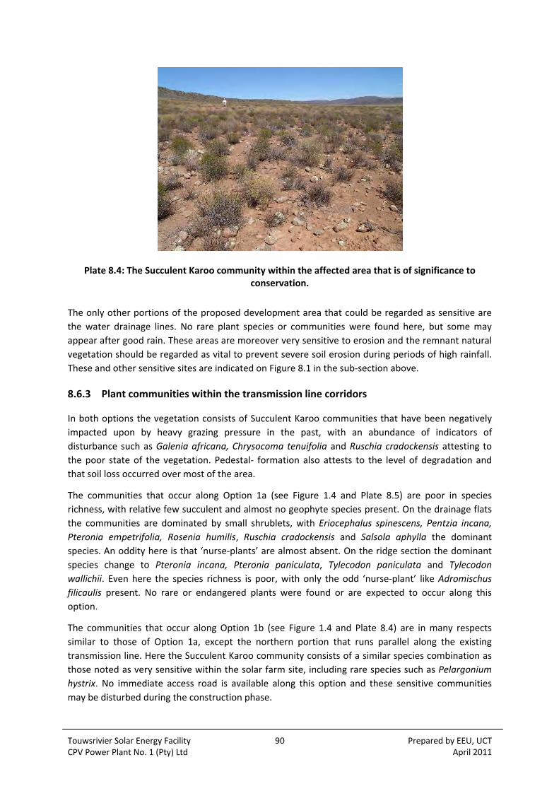
Touwsrivier Solar Energy Facility 90 Prepared by EEU, UCT CPV Power Plant No. 1 (Pty) Ltd April 2011
Plate 8.4: The Succulent Karoo community within the affected area that is of significance to conservation.
The only other portions of the proposed development area that could be regarded as sensitive are
the water drainage lines. No rare plant species or communities were found here, but some may
appear after good rain. These areas are moreover very sensitive to erosion and the remnant natural
vegetation should be regarded as vital to prevent severe soil erosion during periods of high rainfall.
These and other sensitive sites are indicated on Figure 8.1 in the sub‐section above.
8.6.3 Plant communities within the transmission line corridors
In both options the vegetation consists of Succulent Karoo communities that have been negatively
impacted upon by heavy grazing pressure in the past, with an abundance of indicators of
disturbance such as Galenia africana, Chrysocoma tenuifolia and Ruschia cradockensis attesting to
the poor state of the vegetation. Pedestal‐ formation also attests to the level of degradation and
that soil loss occurred over most of the area.
The communities that occur along Option 1a (see Figure 1.4 and Plate 8.5) are poor in species
richness, with relative few succulent and almost no geophyte species present. On the drainage flats
the communities are dominated by small shrublets, with Eriocephalus spinescens, Pentzia incana,
Pteronia empetrifolia, Rosenia humilis, Ruschia cradockensis and Salsola aphylla the dominant
species. An oddity here is that ‘nurse‐plants’ are almost absent. On the ridge section the dominant
species change to Pteronia incana, Pteronia paniculata, Tylecodon paniculata and Tylecodon
wallichii. Even here the species richness is poor, with only the odd ‘nurse‐plant’ like Adromischus
filicaulis present. No rare or endangered plants were found or are expected to occur along this
option.
The communities that occur along Option 1b (see Figure 1.4 and Plate 8.4) are in many respects
similar to those of Option 1a, except the northern portion that runs parallel along the existing
transmission line. Here the Succulent Karoo community consists of a similar species combination as
those noted as very sensitive within the solar farm site, including rare species such as Pelargonium
hystrix. No immediate access road is available along this option and these sensitive communities
may be disturbed during the construction phase.

Touwsrivier Solar Energy Facility 91 Prepared by EEU, UCT CPV Power Plant No. 1 (Pty) Ltd April 2011
Plate 8.5: The Succulent Karoo vegetation along transmission line Option 1a
Plate 8.6: The sensitive Succulent Karoo vegetation along transmission line Option 1b. Here the plant communities are in a better ecological condition, but similar to those depicted in Plate 8.4
Touwsrivier Solar Energy Facility 92 Prepared by EEU, UCT CPV Power Plant No. 1 (Pty) Ltd April 2011
8.7 FAUNA
The faunal baseline information has been sourced from the Faunal Impact Assessment Report
(Coetzee, 2011) attached as Appendix 8.4 and sets out the likelihood of vertebrates (mammal,
reptile, amphibian and avian species) occurring within the study area. The geographic location,
vegetation, physical features, water and disturbance characterising the site all contribute to the
overall habitat potential and therefore the faunal baseline description.
Of particular importance is the likelihood of those species listed as Red Data protected species. Also
considered are those mammals afforded protected status in terms of Section 56(1) of the National
Environmental Management: Biodiversity Act (Act 10 of 2004), and those bird species which are
endemic or near endemic.
8.7.1 Faunal Occurrence
Amphibians
The disturbed area, as well as the Renosterveld and Succulent Karoo provide a limited range of
suitable habitats for amphibians. Of the 12 species identified in the checklist for the general
Touwsrivier area, the presence of only two are considered likely, no species are confirmed, five are
considered a possibility and five species are unlikely to occur (refer to the Faunal Impact Assessment
Report, Appendix 8.4 (Appendix 1) for a checklist).
Only one of this group is listed as a Red Data species, this is the Karoo caco (Cacosternum
karooicum), which is endemic to the western/northern Karoo area and is known from only six
localities. It is a Red List species, with ‘Data deficient’ status, which indicates that little is actually
known about this species (Minter et al, 2004).
Reptiles
Although the presence or absence of reptiles is more difficult to determine as they have a less
predictable habitat, the lack of wetland habitat areas is a key indicator. Three Chelonians (tortoises),
one chameleon, 21 snakes, five geckos and 11 lizards are predicted to occur in the study area. Of
the 53 reptiles predicted to occur, 31 are considered likely to occur (one was confirmed), 10 were
seen as possibilities and 11 were considered unlikely to occur on the site (refer to the Faunal Impact
Assessment Report, Appendix 8.4 (Appendix 2) for a checklist).
None of these reptiles are listed as Red Data species.
Mammals
The disturbed vegetation, as well as the Succulent Karoo and Renosterveld vegetation within the
study site potentially provide habitat for a surprisingly large diversity of mammal types. Those
groups (Orders and Suborders) considered likely to occur are set out in Table 8.1 below, whilst those
unlikely to occur on the study site are excluded.
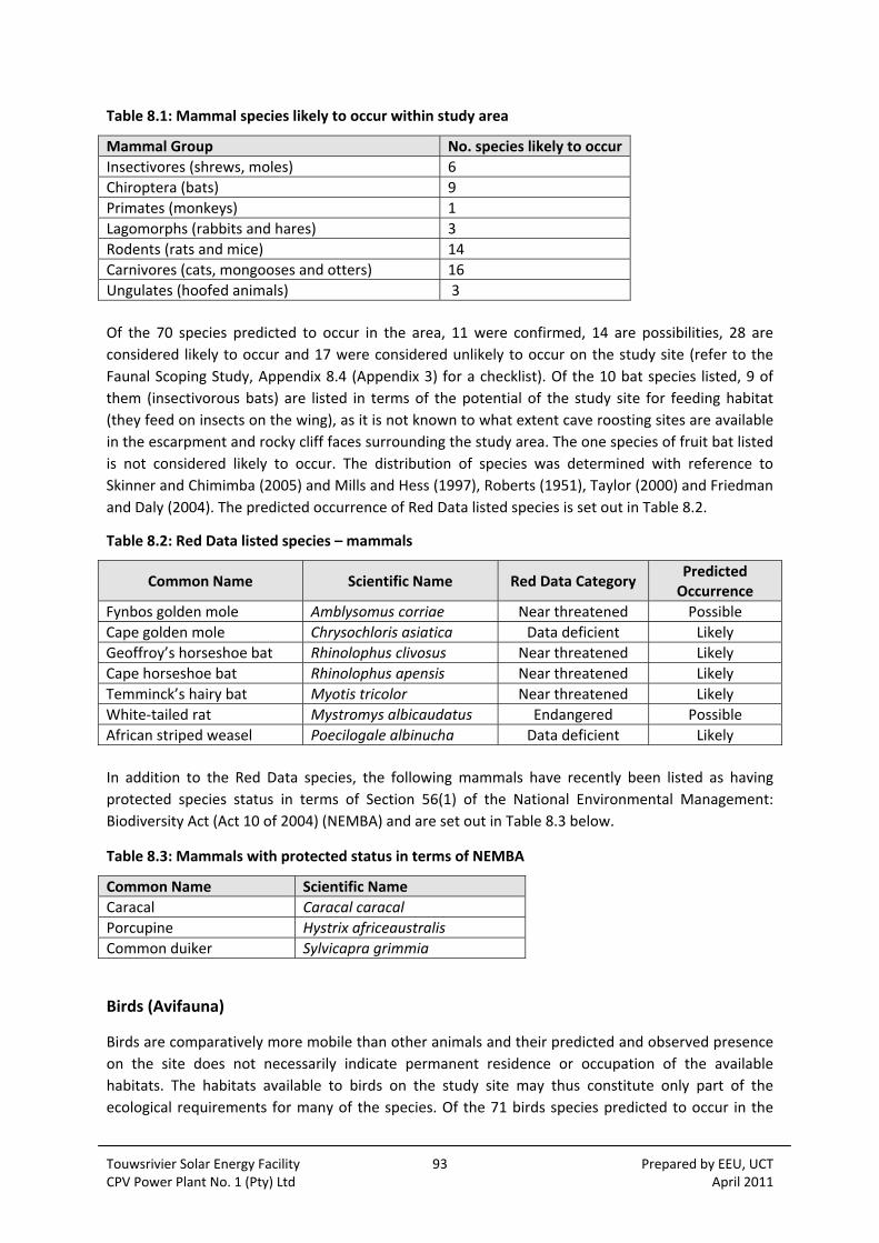
Touwsrivier Solar Energy Facility 93 Prepared by EEU, UCT CPV Power Plant No. 1 (Pty) Ltd April 2011
Table 8.1: Mammal species likely to occur within study area
Mammal Group No. species likely to occur
Insectivores (shrews, moles) 6
Chiroptera (bats) 9
Primates (monkeys) 1
Lagomorphs (rabbits and hares) 3
Rodents (rats and mice) 14
Carnivores (cats, mongooses and otters) 16
Ungulates (hoofed animals) 3
Of the 70 species predicted to occur in the area, 11 were confirmed, 14 are possibilities, 28 are
considered likely to occur and 17 were considered unlikely to occur on the study site (refer to the
Faunal Scoping Study, Appendix 8.4 (Appendix 3) for a checklist). Of the 10 bat species listed, 9 of
them (insectivorous bats) are listed in terms of the potential of the study site for feeding habitat
(they feed on insects on the wing), as it is not known to what extent cave roosting sites are available
in the escarpment and rocky cliff faces surrounding the study area. The one species of fruit bat listed
is not considered likely to occur. The distribution of species was determined with reference to
Skinner and Chimimba (2005) and Mills and Hess (1997), Roberts (1951), Taylor (2000) and Friedman
and Daly (2004). The predicted occurrence of Red Data listed species is set out in Table 8.2.
Table 8.2: Red Data listed species – mammals
Common Name Scientific Name Red Data Category Predicted Occurrence
Fynbos golden mole Amblysomus corriae Near threatened Possible
Cape golden mole Chrysochloris asiatica Data deficient Likely
Geoffroy’s horseshoe bat Rhinolophus clivosus Near threatened Likely
Cape horseshoe bat Rhinolophus apensis Near threatened Likely
Temminck’s hairy bat Myotis tricolor Near threatened Likely
White‐tailed rat Mystromys albicaudatus Endangered Possible
African striped weasel Poecilogale albinucha Data deficient Likely
In addition to the Red Data species, the following mammals have recently been listed as having
protected species status in terms of Section 56(1) of the National Environmental Management:
Biodiversity Act (Act 10 of 2004) (NEMBA) and are set out in Table 8.3 below.
Table 8.3: Mammals with protected status in terms of NEMBA
Common Name Scientific Name
Caracal Caracal caracal
Porcupine Hystrix africeaustralis
Common duiker Sylvicapra grimmia
Birds (Avifauna)
Birds are comparatively more mobile than other animals and their predicted and observed presence
on the site does not necessarily indicate permanent residence or occupation of the available
habitats. The habitats available to birds on the study site may thus constitute only part of the
ecological requirements for many of the species. Of the 71 birds species predicted to occur in the

Touwsrivier Solar Energy Facility 94 Prepared by EEU, UCT CPV Power Plant No. 1 (Pty) Ltd April 2011
general area (either permanently or partly), 11 are confirmed and 60 are considered possibilities or
likely to occur. A full checklist is included in the Faunal Impact Assessment Report Appendix 8.4
(Appendix 4). Distributions were determined with reference to Sinclair et al (1997), Hockey et al
(2005) and Harrison et al (1997).
Of the 71 bird species predicted to occur on the study area, only 2 are listed as Red Data species
(Barnes, 2000). These are the blue crane (classed as Vulnerable) and the black harrier (classed as
Near Threatened).
In addition to the Red Data bird species, the endemic or near endemic bird species of the study area
should also be considered important because these species are endemic to the Subregion, which is
thus entirely responsible for their global survival. The endemic or near‐endemic bird species which
are predicted to occur within the study area are as follows in Table 8.4 ‐ see also the Faunal Impact
Assessment Report, Appendix 8.4 (Appendix 4).
Table 8.4: Endemic and near endemic bird species predicted to occur (Barnes, 2000).
Species Scientific Name Predicted Occurrence
Jackal buzzard Buteo rufofuscus Confirmed
Cape francolin Francolinus capensis Confirmed
Karoo prinia Prinia maculosa Confirmed
Karoo robin Erythropygia coryphaeus Confirmed
Fiscal flycatcher Sigelus silens Confirmed
Lesser double‐collared sunbird Nectarinia chalybea Confirmed
Cape bulbul Pycnonotus capensis Confirmed
Black korhaan Eupodotis afra Possible
8.8 SOCIAL
The social baseline information has been sourced from the Social Impact Assessment Report
(Barbour and van der Merwe, 2011) attached as Appendix 8.5.
8.8.1 Breede Valley Municipality
A socio‐economic profile of the Breede Valley Municipality (BVM) has been collated on the basis of
information provided in the recent Provincial Treasury socio‐economic profile of the BVM (2007).
In 2006, the BVM had the second largest population of the constituent CWDM B‐Municipalities, and
was the third largest contributor to the CWDM’s economy. Economic data for 2005 indicated that
the BVM economy made up 18.9 % of the CWDM’s economy, and was growing at 4.2%, compared to
the CWDM’s growth of 4.8%. The BVM’s main strategic advantages are its relative proximity to the
Cape Town Metropole and large towns in the Boland (Stellenbosch, Paarl, Wellington), as well as
good connectivity provided by the N1, which essentially bisects the BMV from west to east. The
administrative centre of Worcester is has good road and railway connections, which facilitates
access to the markets of the Cape Town Metropole and export markets via Cape Town harbour.
The BVM economy is relatively diversified however, despite this apparent diversification, agriculture
and agro‐processing form an important part of the economy. As such, the economy is likely to be
more sensitive to the impacts associated with climate change. The two biggest sectors, agriculture

Touwsrivier Solar Energy Facility 95 Prepared by EEU, UCT CPV Power Plant No. 1 (Pty) Ltd April 2011
forestry & fishing and wholesale & retail trade; catering & accommodation grew at average
compound rates of 5.2% and 6.4% respectively.
8.8.2 Study area roads and rail line
As indicated on Figure 1.3, the N1 National Road is located ± 1 km north of the proposed site. The N1
provides a direct road link to the Boland and Cape Town to the south‐west, and Beaufort West, the
Orange Free State and Gauteng to the north‐east. The Cape Town is located ±180 km south‐west of
Touwsrivier, Worcester ±75 km, and De Doorns ±40 km. Laingsburg, the next major town on the N1
to the east, is located ±90 km from Touwsrivier.
Two other major roads are located in proximity to the proposed site, namely the north‐south aligned
R318 which intersects with the N1 approximately 7 km west of the site, and the south‐east‐north‐
west aligned R46 which intersects with the N1 approximately 4.5 km east of the site. The R318 links
the N1 to Montagu and the R62 scenic route to the south‐east. The R46 provides a link to the Aquila
Safari and Game Farm, the Verkeerdevlei Dam, and ultimately, the town of Ceres.
Access to individual farms in the study area is obtained via private gravel roads off the N1, R318 and
R46. Two gravel roads currently link the portions of Kleinstraat Farm which are located on either side
of the N1. The proposed site is also skirted to the north by the Cape Town‐Pretoria railway line. The
line forms part of the Shosholoza Meyl rail passenger network, and was previously known as the
Trans‐Karoo route. The internationally renowned luxury Blue Train also uses the line.
8.8.3 Study Area Land Use and Settlement Patterns
Landscape context and sense of place
The study area is a sparsely populated rural area, located within the western section of a
geographical sub‐region traditionally known as the Koup. The Koup is a rather vague term applied to
the area stretching east from the Hex River Mountains (demarcating the edge of the Boland region)
to Beaufort West, including the towns of Touwsrivier, Matjiesfontein and Laignsburg. The Koup in
turn forms part of the more comprehensive arid to semi‐arid Great Karoo region. While the study
area is located in the ecotone between the Fynbos and Succulent Karoo Biomes, vegetation cover in
the study area is sparse and structurally low (shrubs and bushes), with tree‐cover generally limited
to drainage lines. Surface water bodies are limited to a few farm dams tapping mountain runoff;
watercourses are typically ephemeral. Most farms in the area rely on borehole water. The study area
is both drought and fire prone (although typical fuel loads are low). Current long‐term climate
change predictions indicate that the region is likely to get hotter and drier.
The proposed site is located in a short, west‐east aligned valley flanked by the eastern outliers of the
Hexrivier Mountains to the north, and broken terrain (Rooirant, Fransrug) to the south. A number of
prominent hills and ridgelines are located in close proximity to the site. These include Tafelkop (±2
km to the east), and Moordhoogte, which runs parallel and just to the north of the N1. The broken
nature of the terrain generally results in reduced sighting distances. With regard to the proposed
site, this results in the site being visible from the N1 for a relatively short distance. The natural
topography also screens the site from Touwsrivier and the majority of farmsteads on the adjacent
properties. The sense of place provided by the broader landscape is that of natural veld and
expansive, largely undeveloped open space located within a mountainous setting. However, the N1
National Road and the Cape Town‐Pretoria railway line skirt the site to the north and an overhead 66

Touwsrivier Solar Energy Facility 96 Prepared by EEU, UCT CPV Power Plant No. 1 (Pty) Ltd April 2011
kV transmission line traverses the site itself. These elements introduce an industrial element into
the landscape experience. A number of farmsteads, farm structures and small patches of cultivated
fields associated with farming operations are located in close proximity to the N1.
Rural area west of Touwsrivier
The regional settlement pattern consists of a scattering of small towns, separated by long
intervening distances. Due to the aridity and sparse vegetation, the carrying capacity of the land is
limited. As a result economically viable farming units are typically large, and farmsteads and the
associated labourer’s housing, are located at some distance from each other. A number of farms
located in proximity to the proposed site are directly accessed off the N1, with farmsteads/ farm
building complexes located in close proximity to the road (e.g. Hoogland, Kleinstraat, Grootstraat)
(Plate 8.7).
Plate 8.7: Farmstead and cultivated fields on Grootstraat Farm north of the N1
Land use in the area has with time shifted away from traditional stock farming to conservation/
wildlife‐orientated land uses – either as private hunting farms, or as tourism destinations. Existing
operations in proximity to the proposed site include Aquila Safari and Game Farm, Nadini, Hugo’s
Nek, Kleinstraat 740 and Bijstein Private Nature Reserve. The shift in land use is generally
characterised by a shift in ownership patterns, with many of the current owners being relative
newcomers to the area. A number of these owners reside in Cape Town or Gauteng, and only visit
their properties sporadically. The implementation of Extension of Security of Tenure (ESTA)
legislation, coupled with a shift away from traditional farming, has resulted in a general decrease in
employment opportunities on farms and associated tenure in the study area.
Touwsrivier Solar Energy Facility 97 Prepared by EEU, UCT CPV Power Plant No. 1 (Pty) Ltd April 2011
Touwsrivier
Touwsrivier is located approximately 12 km to the north‐east of the proposed Project. A series of
low hills to the south‐west of the town screens the town from the proposed site. The bulk of the
town is located to the south of the N1, and, as such does not benefit from opportunities associated
with passing traffic travelling along the N1. The town’s layout is typical of Apartheid‐era planning,
with the historical town (now called “Paddavlei”) and the newer, essentially non‐white Steenvliet
located in separate areas linked only by a segment of road (Plate 8.8). The town has one secondary
school and two primary schools. Retail and customer services are typical of small rural towns.
Worcester is the nearest major town and provides comprehensive retail and services needs.
The history and fortunes of Touwsrivier are inextricably linked to the main Cape Town‐northern
railway line. The town effectively came into being in the 1870’s in order to provide coaling and
servicing facilities for steam locomotives inland from the arduous Hex River pass. The establishment
of these facilities in turn stimulated the establishment of houses for staff, as well as accommodation
facilities (such as the Hotel Frere) for passengers. For most of its early existence, the town was
essentially a large railway centre. From 1947 to 1959 the town was administrated by the (then)
South African Railways. The town’s importance as rail centre declined after the line became
electrified in the 1950’s, however, siding facilities for goods trains are still in use. During the 1980’s
employment opportunities provided by the (then) South African Railway Services in the town
virtually collapsed, which in turn impacted severely on the town’s economic base.
Current unemployment and seasonal underemployment in Touwsrivier is extremely high –
estimated as high as 65% in winter (pers comm, Januarie, 2010). Employment opportunities in the
town are extremely limited. State grants and remittances constitute the main sources of income for
the community (pers comm, Januarie, 2010). A significant number of community members find
seasonal employment in the agricultural sector – in the Hex River and Koo valleys, as well as in the
Koue Bokkeveld. Few opportunities are available during the winter. Alcohol abuse is traditionally
endemic. Indications from field interviews are that tik (methamphetamine hydrochloride) abuse is
becoming established in the community, especially amongst the youth. Apart from inducing
extremely anti‐social behaviour in users, tik can also lead to irreversible physiological (brain)
damage. The phenomenon is therefore a cause for concern.
As in many towns in the Western Cape, indications are that the town’s population has grown over
the past decade or so due to the influx of farm workers associated with implementation of ESTA
legislation and a shift away from traditional farming towards game farming and conservation. Due to
the relative absence of economic opportunities the town has not witnessed any significant in‐
migration of migrants from the Eastern Cape and other parts of South Africa. The town of De Doorns
is located ±40 km to the south‐west of Touwsrivier via the N1. The scenic Hex River pass is located
on the N1 between De Doorns and the site. The fertile Hex River valley (the easternmost outlier of
the Boland region) around De Doorns, has attracted significant labour‐related in‐migration over the
past decade or so, leading to widely publicised clashes between the original and migrant
(Zimbabwean) communities earlier in 2010.

Touwsrivier Solar Energy Facility 98 Prepared by EEU, UCT CPV Power Plant No. 1 (Pty) Ltd April 2011
Plate 8.8: View to north across Touwsrivier (Steenvliet in foreground)
8.8.4 Socio‐economic Context
Demographic
The data presented in this section has been largely derived from the most recent (2001) Census.
Where possible, this has been supplemented by more recent data from the 2007 Provincial Treasury
Socio‐Economic Profile.
Indications are that the urban population of Touwsrivier has probably increased significantly since
Census 2001, mainly as a result of the influx of farm workers and their families. This in turn is likely
to have negatively affected the town’s unemployment, education, and household income profiles.
i. Population
According to the Provincial Treasury, the projected population of the BVM was estimated at 153 655
for 2007. This represents an increase of approximately 5.2% over the estimated 2001 total. The most
recent data for Touwsrivier is from Census 2001. It seems likely that the population has increased as
a result of farm evictions, but it is difficult to quantify the extent.
Table 8.5: Population for Touwsrivier and the BVM
Population Group Touwsrivier BVM
Number % Number %
Black 129 2 29298 20
Coloured 5956 88 95712 65.5
Indian or Asian 9 528 0.5
White 687 10 20489 14
Total 6781 100 146028 100
Source: Census, 2001
Touwsrivier Solar Energy Facility 99 Prepared by EEU, UCT CPV Power Plant No. 1 (Pty) Ltd April 2011
As indicated in Table 8.5 above, in 2001 the Coloured population group made up the majority in both
Touwsrivier (88%) and BVM (65.5%). In contrast to the BVM (20%), only a small Black population was
recorded for Touwsrivier (2%). This is likely to be directly related to the lack of economic
opportunities in Touwsrivier and the surrounding area, as compared to the Hex River Valley
(farming) and Worcester (manufacturing, industry, construction and services). In terms of language,
the majority of people in Touwsrivier (98%) and the BVM (80.5%) spoke Afrikaans as their first
language.
ii. Education levels
As indicated in Table 8.6 below, general education levels for both populations were relatively low.
Thus, according to Census data, approximately 25.5% of the population of Touwsrivier aged 20 and
older was estimated to be functionally illiterate/innumerate in 2001. The percentage for the BVM
was even higher, namely 28.5%. The 2007 Treasury Profile has identified low education levels as a
major risk to further development of the BVM. According to the document, testing of learners has
shown disconcertingly poor performance. A further cause of concern is the fact that a large
proportion of learners abandon schooling after Grade 9. In view of the urbanization of farm workers
over the past decade, reskilling of people with only basic primary (agricultural labour) skills has been
identified as a significant priority for the BVM.
Table 8.6: Education levels for the study area (population 20 and older)
Description Touwsrivier % BVM %
No schooling 8 7.5
Some primary 17.5 21
[% functional illiteracy/ innumeracy]1 [25.5] [28.5]
Complete primary 9 9.5
Some secondary 48 37.5
Std 10/Grade 12 14.5 19
Higher 3 6.5
Source: Census, 2001
iii. Employment levels
The employment information presented in Table 8.7 below indicates that in 2001 only an estimated
18.5% of the Touwsrivier population of working age was employed, compared to 51.5% for the BVM.
While unemployment in Touwsrivier was estimated at 24.5% (more or less on par with the national
rate in 2001), labour participation was extremely low, namely 43% (compared to 64% for the BVM).
This situation reflects the general lack of employment opportunities in Touwsrivier. Unemployment
rates in the town are also assumed to have increased since 2001 as a result of labour shedding by
the agricultural sector. According to the BVM IDP, the unemployment rate in Touwsrivier was higher
than 50% in 2007. The BVM Ward 1 Councilor has provided an even higher estimate, namely 65%
(pers comm, Januarie, 2010).
1 In the South African context, having obtained a primary qualification (i.e. having successfully passed Grade 7) is generally held as the absolute minimum requirement for functional literacy/numeracy. The National Department of Education’s ABET (Adult Basic Education and Training) programme provides education and training up to the equivalent of Grade 9. In this more onerous definition, Grade 9 is required as the minimum qualification for having obtained a basic education (www.abet.co.za).

Touwsrivier Solar Energy Facility 100 Prepared by EEU, UCT CPV Power Plant No. 1 (Pty) Ltd April 2011
Table 8.7: Study area employment levels (15 – 64 age group)
Description Touwsrivier % BVM %
Employed2 18.5 51.5
Unemployed 24.5 12.5
Not Economically Active 3 57 36
Source: Census, 2001
iv. Household income
Poverty levels in the study area are extremely high. Census data for 2001, presented in Table 8.8,
indicates that 66.5% of households in Touwsrivier, and 49.5% of those in the BVM were living below
the minimum subsistence level (pegged at R1600/month in 2001). Around 50% of each of the
communities was clustered in the R400‐R1600 income category. With regard to Touwsrivier, 87% of
households had an income of less than R3 200 per month.
Table 8.8: Study area income levels (for head of household)
Income per month Touwsrivier % BVM %
No formal income 19 9
R 1 – R 400 7.5 3
R 401 – R 800 19.5 14.5
R 801 ‐ R 1 600 20.5 23
[% households below minimum subsistence level] [66.5] [49.5]
R1 601 ‐ R 3 200 20.5 22
R 3 201 – R 6 400 9.5 14
R 6 401 – R 12 800 2.5 9
R 12 801 – R 25 600 1 4
R 25 601 and higher ‐ 1.5
Source: Census, 2001
v. Sectoral employment
Table 8.9 below provides an overview of proportional employment per economic sector for the
labour forces of both relevant populations. In this regard, the data shows that the agricultural sector
was the main provider of employment opportunities in the BVM (47.5%), followed by Community,
Social and Personal Services. With regard to Touwsrivier, the Community, Social and Personal
Services sector was the main provider of employment (33%), followed by the Wholesale and Retail
trade (24%) and Agriculture sectors (13.5%). The importance of the Community, Social and Personal
Services sector appears linked to the public sector (local government) employment while the
Wholesale and Retail Trade sector is in part associated with passing traffic traveling along the N1.
2 Census 2001 official definition of an unemployed person: “A person between the ages of 15 and 65 with responses as follows: ‘No, did not have work’; ‘Could not find work’; ‘Have taken active steps to find employment’; ‘Could start within one week, if offered work’.” (www.statssa.gov.za). 3 The term “not economically active“ refers to people of working age not actively participating in the economy, such as early retirees, students, the disabled and home‐makers.
Touwsrivier Solar Energy Facility 101 Prepared by EEU, UCT CPV Power Plant No. 1 (Pty) Ltd April 2011
Table 8.9: Sectoral contribution to employment
Description Touwsrivier % BVM %
Agriculture, hunting, forestry and fishing 13.5 47.5
Mining and quarrying - -
Manufacturing 4 7.5
Electricity, gas and water supply 1 0.5
Construction 5.5 3.5
Wholesale and retail trade 24 13
Transport, storage and communication 11.5 3
Financial, real estate and business services 3 4.5
Community, social and personal services 33 16
Other and not adequately defined - -
Private households4 4.5 4.5
Agricultural land uses
Sheep farming is the traditional mainstay of the rural farming economy in the Touwsrivier area,
supplemented by the small‐scale cultivation of cereals and fodder crops. Some small‐scale
diversification to ostriches is also taking place (e.g. on Kleinstraat and Vredefort Farms in the study
area). Relatively little beneficiation of primary produce (meat, wool, hides) takes place locally.
For a number of reasons – including vulnerability to stock theft – many traditional sheep farms are in
the process of shifting towards game farming/ conservation, beef cattle or both. In terms of game
farming/ hunting farms/ conservation, the study area benefits from its relative accessibility from
Cape Town and the Boland. Sheep farming does not provide many employment opportunities, and
some opportunities are only seasonal (e.g. shearing). Conservation/ game farming typically offer
even fewer employment opportunities.
The cultivation of dryland cereal crops was always somewhat marginal in the region, with relatively
low yields (0.8 ‐ 1 t/ ha), and vulnerability to unpredictable rainfall patterns. As a result cropping
operations have shifted towards the cultivation of irrigated crops – fodder crops such as alfalfa,
limited stone fruit orchards, vegetables, and more recently, table grapes. Total plantings are limited,
mainly as a result of topography, the availability of borehole water, and the cost of irrigation
infrastructure.
The fertile Hex River Valley is located ±25 km west of the site and ±35 km west of Touwsrivier. The
Hex River Valley, which benefits from long, hot summers and abundant irrigation water, is the
primary table grape producing area in South Africa. An estimated 600 people from Touwsrivier find
seasonal employment (harvesting time) in the Hex River Valley. Workers are typically driven in on a
daily basis (pers comm, Pietersen, 2010).
Tourism
At present, relatively few major tourism destinations are located in the Touwsrivier area. The
Touwsrivier Tourism Association has only recently been established. While the N1 carries major
traffic and tourism flows through the study area, current tourist opportunities are largely associated
with wilderness‐based destinations. Of these, Aquila Private Game Reserve (4,500 ha, located off the
R46, approximately 5 km north of the site) is the best known. A number of other established – e.g.
4 This category mainly comprises domestic workers and gardeners.
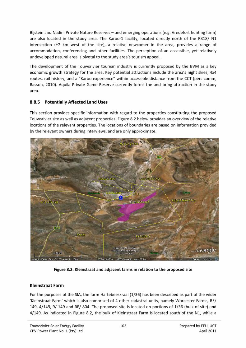
Touwsrivier Solar Energy Facility 102 Prepared by EEU, UCT CPV Power Plant No. 1 (Pty) Ltd April 2011
Bijstein and Nadini Private Nature Reserves – and emerging operations (e.g. Vredefort hunting farm)
are also located in the study area. The Karoo‐1 facility, located directly north of the R318/ N1
intersection (±7 km west of the site), a relative newcomer in the area, provides a range of
accommodation, conferencing and other facilities. The perception of an accessible, yet relatively
undeveloped natural area is pivotal to the study area’s tourism appeal.
The development of the Touwsrivier tourism industry is currently proposed by the BVM as a key
economic growth strategy for the area. Key potential attractions include the area’s night skies, 4x4
routes, rail history, and a “Karoo‐experience” within accessible distance from the CCT (pers comm,
Basson, 2010). Aquila Private Game Reserve currently forms the anchoring attraction in the study
area.
8.8.5 Potentially Affected Land Uses
This section provides specific information with regard to the properties constituting the proposed
Touwsrivier site as well as adjacent properties. Figure 8.2 below provides an overview of the relative
locations of the relevant properties. The locations of boundaries are based on information provided
by the relevant owners during interviews, and are only approximate.
Figure 8.2: Kleinstraat and adjacent farms in relation to the proposed site
Kleinstraat Farm
For the purposes of the SIA, the farm Hartebeeskraal (1/36) has been described as part of the wider
‘Kleinstraat Farm’ which is also comprised of 4 other cadastral units, namely Worcester Farms, RE/
149, 4/149, 9/ 149 and RE/ 804. The proposed site is located on portions of 1/36 (bulk of site) and
4/149. As indicated in Figure 8.2, the bulk of Kleinstraat Farm is located south of the N1, while a

Touwsrivier Solar Energy Facility 103 Prepared by EEU, UCT CPV Power Plant No. 1 (Pty) Ltd April 2011
small portion is located north of the N1. The farmstead is located on the section to the north of the
N1. A gravel road that crosses the N1 provides direct access from the farmstead to the bulk of the
farm located south of the N1. The portion south of the N1 can also be accessed by a gravel road
located opposite Hoogland Farm. This road is proposed as access road to the proposed site for the
construction, operational and decommissioning phases.
Kleinstraat Farm was recently acquired by the Abundance Foundation, which also owns the Aquila
Private Game Reserve, located off the R46, ±5 km north of the proposed site (property immediately
to the north of Grootstraat Farm). No information could be obtained with regard to dedicated
employment and tenure on Kleinstraat, but it appears that the farm is essentially integrated into the
operations on Aquila.
The portion of Kleinstraat Farm north of the N1 is currently in the process of being developed for
tourism, viz. a Bush camp (accommodation) and ostrich ranch. The portion south of the N1 is
currently used for the cultivation of irrigated fodder crops, mainly for use at Aquila as
supplementary feed (Plate 8.9), this is not part of the site. Total plantings are limited, and essentially
restricted to a few ha immediately south of the N1. A small herd of sheep (±10) utilises grazing on
the portion south of the N1, but is apparently in the process of being phased‐out (pers comm,
Coetzer, 2011). The farm portion on which the proposed facility is located is not used for any
productive purposes at present. Marginal fields, historically used for the dryland cropping of cereals,
were decommissioned over the past decade or more. As previously described, this site is traversed
by the Cape Town‐Pretoria railway line, a 66 kV Eskom line, and associated service roads. A Transnet
substation is also located within this portion.
Plate 8.9: Irrigated fodder crops on the portion of Kleinstraat south of the N1

Touwsrivier Solar Energy Facility 104 Prepared by EEU, UCT CPV Power Plant No. 1 (Pty) Ltd April 2011
Adjacent Properties
A summary of ownership, land use, associated employment and tenure for the relevant properties is
provided in Table 8.10 below. Two of the landowners (Du Toit and Heidenrich) could not be reached
for interviews. Information for these relevant properties was obtained from neighbours. None of
these properties make use of the road proposed for access to the proposed site (see Section 3 for
Project Description).
Table 8.10: Overview of properties adjacent to the proposed site
Landowner Property Land Uses Owner Resident Dedicated Labour/ Associated Tenure
Arand Trust
(Mr. André Marais)
Hugo’s Nek
[2/37]
Acquired in 2008, mainly for weekend use and as private hunting farm; currently in the process of establishing game fencing and stocking with game;
Future plans for limited tourist accommodation
Owner based in CT but visits approximately every second weekend.
None
Dirk Uys Boerdery
Nadini
[RE/ 148]
Private Nature Reserve and tourist residential;
Private airstrip located on Nadini
Yes Yes, but numbers unknown
Du Toit, Mr. Jacques
Ratelbos
[2/157; 1/149]
Stud cattle farming Owner based in CT, but manager lives on property
Yes, but numbers unknown
Grootstraat Trust
(Jordaan Brothers)
Grootstraat
[6/36]
Irrigated fodder crops (20 ha) and orchards (3 ha);
Beef cattle (±80);
Confirmed suitable soils and available irrigation water for planting ca. 190 ha of table/ wine grapes;
Future plans for establishing game and limited upmarket tourist accommodation facilities
Owners based in Hex River Valley, but visit farm a few times per week
5 Permanent employees;
4 households tenured on farm
Heidenrich, Mr Hans
Kleinstraat
[740]
Apparently acquired for purpose of establishing a hunting farm, and currently in the process of developing such. Commercial hunting is envisaged within the next 1‐2 years.
Owner lives in Gauteng
None
RZT Zelpy 4390 Pty Ltd
(50% Naude Farms; 50% Denau Labourer’s Trust)
Hoogland
[803]
36 ha of established irrigated table grapes;
Potential for establishing additional 14 ha
No, but farm manager on‐site during working hours
13 permanent labourers (all from Touwsrivier)
Seasonal (harvesting) opportunities for ±40 (mainly from Touwsrivier)
No workers tenured on property

Touwsrivier Solar Energy Facility 105 Prepared by EEU, UCT CPV Power Plant No. 1 (Pty) Ltd April 2011
Properties potentially affected by grid connection alternatives
As was discussed in Section 4.8 (Grid Connection Alternative), Option 2 would entail a direct, on‐site
linkup to an existing 66 kV line which traverses the site, and would not require any transmission line
infrastructure to be constructed.
Option 1a would entail the construction of ±5 km of transmission infrastructure on Hartebeeskraal
1/36 (i.e. Kleinstraat Farm), parallel to the boundary fence (with Farm 740) and an existing access
track. Please refer to the sections above for an overview of existing land uses on the site. Please
refer to Table 8.10 above) for details of Farm 740.
Option 1b would entail the construction of ±7 km of transmission infrastructure. The proposed
alignment would run parallel to an existing 66 kV line and the Cape Town‐Pretoria railway line. This
alternative would traverse Farm 740 (see Table 8.10 above) and Farm RE/34. Farm RE/34 is owned
by Mr Casper Wolff. The property is used for livestock, namely cattle and sheep and is also used for
breeding ostriches.
8.9 VISUAL
The land use and physical character of the site has been set out in Sections 8.4.1, 8.5 and 8.6 above.
A description of the visual baseline is provided in the Visual Impact Assessment (Oberholzer and
Lawson, 2011) in Appendix 8.6.
The site is briefly described in Table 8.11 below, including the visual/scenic significance, along with
visual opportunities and constraints in relation to the siting of solar energy facilities. Viewpoints and
viewsheds are indicated on Figure 4 (in Appendix 8.6), and photographic images from various
viewpoints are given in Figures 5 and 6 (in Appendix 8.6).
Table 8.11: Landscape Description of the Site
Location
The site is located within the Breede River Municipal area, some 12 km south‐west of the town of Touwsrivier, on a portion of the Farm Hartebeeskraal, Erf 36 and Ratelbosch Erf 149 (see Figure 1.2). The site lies in close proximity to the N1 National Road and a major rail route. There are no other major roads on or adjacent to the site, while two older rail routes across the site have been decommissioned. The site is approximately 4.5 km long and 1.5 km at its widest point.
Geology The landscape is characterized by relatively flat terrain interrupted by subtle hills or ridges resulting from the dipping, alternating layers of shale and harder sandstone formations of the Bokkeveld Group of rocks.
Physical Landscape
The low ridges provide some visual screening for parts of the site and are more visually sensitive than the surrounding plain because of silhouette effects on the skyline.
The two drainage lines on the site tend to be dry for most of the year, but flash floods are experienced from time to time, during which the banks can be breached, and braided channels formed. Small earth dams have been constructed in places along the drainage routes.

Touwsrivier Solar Energy Facility 106 Prepared by EEU, UCT CPV Power Plant No. 1 (Pty) Ltd April 2011
Vegetation Cover
Both Renosterveld and Succulent Karoo types of vegetation occur on the site, while trees are largely absent from the landscape, except for a few localized clumps in the upper reaches of the drainage courses. The low, sparse vegetation offers little visual screening for structures in the characteristically open landscape. The proposed site has been extensively grazed in the past.
The Succulent Karoo vegetation type was identified as being sensitive and having biodiversity value. The vegetation of the drainage lines is also sensitive, (Vlok, 2011). These areas could subsequently be considered to have landscape value.
Viewshed and view corridors
Because of the relatively low height of the solar trackers (approximately 7.5 m) and the hilly topography surrounding the site, the viewshed tends to be localised, being mainly within a 5 km radius of the site. The site is visible from the N1 and railway view corridors over a distance of about 4 km, the distance being confined by the topography (see Figure 4 in Appendix 8.6).
Visual Significance
The surroundings are predominantly agricultural or natural karoo‐type veld in character ‐ an area known, and revered, for its open expansiveness and rocky ‘koppies’. The scenic quality of the area has, however, been compromised by railway cuttings and pylons, as well as by Eskom transmission lines, an existing electrical substation and various borrow pits and spoil heaps. The arid climate means that the agriculture is marginal.
Opportunities and Constraints
The proposed site is highly visible from the N1 National Road and the railway line, which carries passengers and goods between major centers. The importance of these two routes at the regional and national scale means that they could be considered as scenic corridors.
The site is visible from a farmstead on the north side of the N1, but not visible from any towns or other settlements. The site is also not overlooked by any nature reserves or other protected landscapes, although guest accommodation is apparently planned in areas visible from the site. The Touw Nature Reserve is about 8 km to the north‐east of the site. The site could possibly be visible from the Bokkeriviere Nature Reserve on the Witberg Mountain, some 10 km to the west, but distance would be a mitigating factor.
Viewpoints were selected based on prominent viewing positions in the area, where uninterrupted
views of the proposed energy facilities could be obtained. The proposed facilities would be
potentially visible from the N1 National Road, the main rail line and a number of farms. Table 8.12
overleaf describes the potential visibility from the selected viewpoints.

Touwsrivier Solar Energy Facility 107 Prepared by EEU, UCT CPV Power Plant No. 1 (Pty) Ltd April 2011
Table 8.12: Potential Visibility from Selected View Points
View Point
Location Distance Comments
VP1 N1 National Road near crest looking south
1.1 km Highly visible, but with rail line and Eskom transmission lines in foreground.
VP2 N1 at farm entrance 0.9 km Highly visible, partly obscured by railway embankment and dam wall.
VP3 Rail crossing, Kleinstraat Site boundary
Highly visible, but not a sensitive view site.
VP4 Rail tunnel entrance/exit 100 m Highly visible along railway line. Partly obscured by existing spoil heap.
VP5 N1 looking south‐east from Moordhoogte
2.2 km Visible in middle distance looking down the N1.
VP6 Hugo’s Nek 3.3 km Marginally visible in the distance, partly obscured foreground ridge.
8.10 HERITAGE
The heritage baseline information has been sourced from the Heritage Impact Assessment (Hart,
2011) attached as Appendix 8.7. Although characteristically Karoo, the landscape has been subject to
previous activity and is not considered to be pristine (see Plate 8.10 and Plate 8.11 ). Agriculture has
been attempted over a wide area, several dams have been constructed which means that
substantial transformation has taken place in some areas. The site has also been subject to major
industrial activity being the east portal for the new railway tunnel and alignment as well as the site
for an earlier attempt in 1946. Many areas show evidence of disturbance caused by heavy plant,
construction and lay down yards. There is an existing Eskom electrical distribution line and Transnet
substation on the site as well as two decommissioned railway alignments. The main western system
railway between Cape Town and Johannesburg passes very close to the site. Hence the proposed
activity would be highly visible from the N2 and the existing railway.

Touwsrivier Solar Energy Facility 108 Prepared by EEU, UCT CPV Power Plant No. 1 (Pty) Ltd April 2011
Plate 8.10: View over agricultural lands in the study area. The N2 can be seen in the distant
background.
Plate 8.11: Old lay down yard and unsightly tailings from the 1989 Hexton Tunnel
Touwsrivier Solar Energy Facility 109 Prepared by EEU, UCT CPV Power Plant No. 1 (Pty) Ltd April 2011
8.10.1 Palaeontology
The palaeontology has been documented by John Almond (Appendix 8.8) and detailed in Section
8.11 below.
8.10.2 Archaeology
The archaeology of the site has never been described before, however a number of recent surveys
conducted on various projects within a radius of 80 km of the site indicate that archaeological
conditions are varied. Hart and Orton (2010) and Halkett, Hart and Webley (2010) have recently
completed surveys of a variety of Karoo landscapes between Sutherland and Touwsrivier and have
documented a number of common trends.
The mountain ridges such as the Witteberg that mark the interface of the Cape Fold Belt with the Karoo geology contain very sparse archaeological sites in their upper reaches – they are formidably windy and very cold in winter. Where there are sheltered areas such as behind large boulders, ephemeral Late Stone Age archaeological sites may be encountered, at times with San rock art.
Khoikhoi stone stock kraals have been located on the upper escarpment towards Sutherland. Some of these contain Cape Coastal Pottery. Large presumably Khoikhoi camps have been recorded in valley bottoms at the edge of the escarpment. These rich sites contain large amounts of pottery, crude informal stone artefacts, ash piles, piled stone features (possibly graves) and in some instances colonial period ceramics.
Early and Middle Stone Age archaeological material is relatively common. It may be encountered on the flat plains above and below the escarpments as well as in valley bottoms. It occurs ubiquitously as wide spread scatters in the agricultural areas of the Western Cape.
The historical archaeology of the Karoo and the Cape Fold Belt mountains around its edge is prolific but almost completely un‐studied. Ruins of Voortrekker or transhumant (moving from area to area on a seasonal cycle). Boer stock farmer’s dwellings (opstalle) are numerous. Indications are that the Great Karoo was substantially more heavily populated in the 19th century than today. There is also archaeological evidence that cereal farming and fruit cultivation (albeit small scale) was occurring in areas that are un‐farmable by today’s standards.
8.10.3 Built Environment
The study area is situated at a point on the main western railway system which was the focus of
much railway related activity. This was largely due to the fact that the site is on the upper
escarpment of the Hex River Mountains, at the gateway to the Karoo. The site served as a logical
launch area for various attempts to tunnel through the mountains to avoid the time consuming
railway bottleneck of the Hex River Pass. There are, in addition to the existing Trans‐Karoo main
railway line, alignments of two older railway lines in the study area, both of which were part of the
historic Hex River Railway pass that descended into the Karoo from Matroosberg Station. The first
railway alignment was built in 1876, but was abandoned in 1930 after a new section to Matroosberg
was built. The second railway alignment, built in 1930 served until 1980 when the Hex River rail
tunnel was completed, after which all rail traffic was diverted through the tunnel eliminating the
need to use the historic pass any longer (a local tourism operator runs a small train on the surviving
section of the pass between Matroosberg and De Doorns).

Touwsrivier Solar Energy Facility 110 Prepared by EEU, UCT CPV Power Plant No. 1 (Pty) Ltd April 2011
For much of the 19th century the Cape Fold Belt Mountains were considered to be an obstacle to
building a railway line into the interior, however the improved financial position of the Cape
Government after the discovery of diamonds at Kimberly in the 1860’s, and the adoption of the 3’6”
railway gauge made this economically possible.
The adoption of the 3’6” gauge (which came to be known as the Cape Gauge) in 1873 set the
standard for Southern Africa. The old 4’8½” gauge was still used within a dual system on the
Wellington and Wynberg lines until the 1880s, after which the tracks were replaced (Leendertz,
1993) From this point onwards all rolling stock and locomotives used in southern Africa had to be
manufactured to operate on what became known as the Cape Gauge. The result of this was the
growth of a significant local industry producing equipment, trucks, coaches, and eventually
locomotives for use in southern Africa. Although the Cape Fold Belt Mountains were the
motivational force that led to the adoption of the Cape Gauge, the Hex River Pass line cannot claim
sole credit for motivating this decision. Examination of the available sources has shown that the
Cape Government Railways adopted the Cape Gauge to overcome the initial problems of extending
the line from Wellington to Worcester through the Du Toits Kloof Mountains. It was only after the
construction work had begun on the Cape Gauge line from Wellington to Worcester that W.G.
Brounger appointed Wells Hood to survey a route through towards Beaufort West. By the time that
the decision was made to adopt the Cape Gauge, the route from Worcester into the Karoo had not
yet been decided on.
An examination of the history of railways in South Africa has shown that most of the main lines in
the country were already operational by the time of the South African War in which they played a
key role. The development of the system had a profound effect on both the economic development
and the process of colonisation of nations to the north. Before the Western Rail System reached
Bulawayo, it took up to two and a half months to complete the journey by wagon. By 1897 it was
possible for a passenger to embark on a train at Cape Town and be in Bulawayo six days later. Not
only could the rail system deliver heavy loads of goods great distances at relatively high speeds, but
its contribution to efficient government control and expansion from the capital was enormous
(Bolze, 1968).
The Hex River Pass is therefore a small portion of what is, in reality, a historically significant national
railway network that has played a central role in the 19th and 20th century history of South Africa.
The Ninham Shand study of 1999 found reason to justify special status for the Hex River railway pass
in terms of the fact that it was the oldest railway pass in South Africa, and while Cape Town was the
capital of the Cape Colony, it was the government’s life‐line into the interior.
The railway tunnels
The study area is the site of two enterprises to tunnel through the Hex River Mountains to eliminate
the need to use the pass. The first of these was authorized in the 1940s and work was abandoned in
1946 after the construction of the east and west portals (financial and technical problems)( see Plate
8.13). The east portal was equipped with a power station (Eskom power was not available). By 1950
the availability of electric locomotives (Class 4E electric units) powerful enough to handle 1000 ton
trains over the pass, resulted in deferment of the tunnel scheme until 1979 when it was re‐designed
and tunnelling commenced in 1981 (Rhind, 1989). After completion of the 13.4 km Hexton tunnel in
1989, the old Hex River Railway pass was decommissioned after having served for more than 100
years

Touwsrivier Solar Energy Facility 111 Prepared by EEU, UCT CPV Power Plant No. 1 (Pty) Ltd April 2011
Touwsrivier
Touwsrivier formed as a direct result of the old railway pass. Originally called Montague Road, its
status as a railway junction grew with the need to double up locomotives hauling trains up and down
the pass. Additional locomotives were kept steamed up and ready to assist, trains could be shunted
off the main line while they awaited their turn to ascend the pass. The shunting yard was also a
place where rolling stock could be stored, maintained and repaired. The completion of the railway
tunnel in 1989 brought to an end the reason for Touwsrivier’s existence as there was no further
need for the railway junction. Today the long railway history of the town is celebrated by the
existence of a sole steam locomotive “plinthed” in the municipal park. A few of the railway sheds
remain and are used for the refurbishment of rolling stock, however almost all the permanent way
material has been lifted (see Plate 8.14). The downgrading of the rail infrastructure has left
Touwsrivier, which was essentially a railways dependent town, in difficult times. Employment
opportunities are few, indigence is high.
Plate 8.12: The old railway service road and rail cutting of the 1930 railway alignment (closed in 1989)
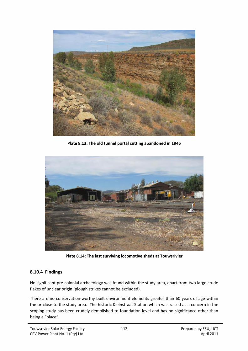
Touwsrivier Solar Energy Facility 112 Prepared by EEU, UCT CPV Power Plant No. 1 (Pty) Ltd April 2011
Plate 8.13: The old tunnel portal cutting abandoned in 1946
Plate 8.14: The last surviving locomotive sheds at Touwsrivier
8.10.4 Findings
No significant pre‐colonial archaeology was found within the study area, apart from two large crude
flakes of unclear origin (plough strikes cannot be excluded).
There are no conservation‐worthy built environment elements greater than 60 years of age within
the or close to the study area. The historic Kleinstraat Station which was raised as a concern in the
scoping study has been crudely demolished to foundation level and has no significance other than
being a “place”.
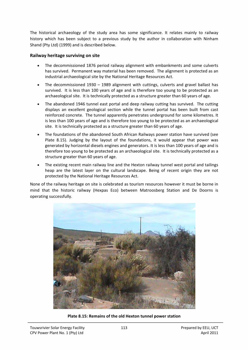
Touwsrivier Solar Energy Facility 113 Prepared by EEU, UCT CPV Power Plant No. 1 (Pty) Ltd April 2011
The historical archaeology of the study area has some significance. It relates mainly to railway
history which has been subject to a previous study by the author in collaboration with Ninham
Shand (Pty Ltd) (1999) and is described below.
Railway heritage surviving on site
The decommissioned 1876 period railway alignment with embankments and some culverts has survived. Permanent way material has been removed. The alignment is protected as an industrial archaeological site by the National Heritage Resources Act.
The decommissioned 1930 – 1989 alignment with cuttings, culverts and gravel ballast has survived. It is less than 100 years of age and is therefore too young to be protected as an archaeological site. It is technically protected as a structure greater than 60 years of age.
The abandoned 1946 tunnel east portal and deep railway cutting has survived. The cutting displays an excellent geological section while the tunnel portal has been built from cast reinforced concrete. The tunnel apparently penetrates underground for some kilometres. It is less than 100 years of age and is therefore too young to be protected as an archaeological site. It is technically protected as a structure greater than 60 years of age.
The foundations of the abandoned South African Railways power station have survived (see Plate 8.15). Judging by the layout of the foundations, it would appear that power was generated by horizontal diesels engines and generators. It is less than 100 years of age and is therefore too young to be protected as an archaeological site. It is technically protected as a structure greater than 60 years of age.
The existing recent main railway line and the Hexton railway tunnel west portal and tailings heap are the latest layer on the cultural landscape. Being of recent origin they are not protected by the National Heritage Resources Act.
None of the railway heritage on site is celebrated as tourism resources however it must be borne in
mind that the historic railway (Hexpas Eco) between Matroosberg Station and De Doorns is
operating successfully.
Plate 8.15: Remains of the old Hexton tunnel power station
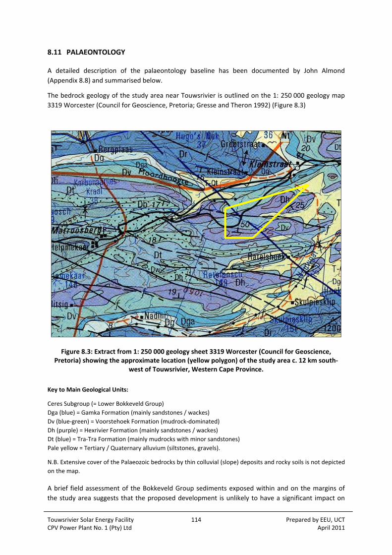
Touwsrivier Solar Energy Facility 114 Prepared by EEU, UCT CPV Power Plant No. 1 (Pty) Ltd April 2011
8.11 PALAEONTOLOGY
A detailed description of the palaeontology baseline has been documented by John Almond
(Appendix 8.8) and summarised below.
The bedrock geology of the study area near Touwsrivier is outlined on the 1: 250 000 geology map
3319 Worcester (Council for Geoscience, Pretoria; Gresse and Theron 1992) (Figure 8.3)
Figure 8.3: Extract from 1: 250 000 geology sheet 3319 Worcester (Council for Geoscience, Pretoria) showing the approximate location (yellow polygon) of the study area c. 12 km south‐
west of Touwsrivier, Western Cape Province.
Key to Main Geological Units:
Ceres Subgroup (= Lower Bokkeveld Group)
Dga (blue) = Gamka Formation (mainly sandstones / wackes)
Dv (blue‐green) = Voorstehoek Formation (mudrock‐dominated)
Dh (purple) = Hexrivier Formation (mainly sandstones / wackes)
Dt (blue) = Tra‐Tra Formation (mainly mudrocks with minor sandstones)
Pale yellow = Tertiary / Quaternary alluvium (siltstones, gravels).
N.B. Extensive cover of the Palaeozoic bedrocks by thin colluvial (slope) deposits and rocky soils is not depicted
on the map.
A brief field assessment of the Bokkeveld Group sediments exposed within and on the margins of
the study area suggests that the proposed development is unlikely to have a significant impact on

Touwsrivier Solar Energy Facility 115 Prepared by EEU, UCT CPV Power Plant No. 1 (Pty) Ltd April 2011
local fossil heritage. Most of the Bokkeveld Group bedrocks are mantled by superficial deposits (e.g.
alluvium, soils) that are themselves of low palaeontological sensitivity. This is especially the case in
the low‐lying, flatter portions of the study area that will be most directly affected by the proposed
development. The fossil potential of a substantial proportion of the near‐surface Bokkeveld
mudrocks has been compromised by chemical weathering and tectonic cleavage. High‐volume
excavations into fresher mudrocks at depth are not envisaged for this development. Although field
scoping shows that invertebrate fossils are widely present, and locally abundant, within the
Voorstehoek Formation that underlies the central part of the study area, palaeontological material
here is generally sparse. Apart from ill‐defined traces (burrows etc), fossils are apparently scarce
within the remaining Bokkeveld Group formations represented within the study area (i.e. Gamka,
Hexrivier and Tra‐Tra Formations).
The Option 1a transmission line (the preferred option) extending to the southeast of the solar
energy facility traverses lower Bokkeveld Group sediments – including the Voorstehoek Formation ‐
in the northeast, close to the railway line, but overlies gritty sands (T‐Qt) over most of its length.
Excavations for the relatively small number pylon foundations envisaged would probably have a
minimal impact on local fossil heritage.
The Option 1b transmission line is underlain by a similar spectrum of sedimentary formations (Lower
Bokkeveld Group plus sandy superficial drift) and is likewise considered to pose a minimal threat to
local fossil heritage.
8.12 TRANSPORT INFRASTRUCTURE
The rail infrastructure includes the Trans‐Karoo alignment running along the northern perimeter of
the site (and associated railway heritage described above). The nearest station is Kleinstraat Railway
Station approximately 1 km to the east, with Hugo Railway Station further approximately 5 km along
the line to the north‐east. Touwsrivier Railway Station is located within the town approximately 11
km to the north‐east of the site.
There is limited road infrastructure within and surrounding the site. The N1 National Road connects
Cape Town with the interior and passes approximately 1 km north of the site. There is a local access
road which connects the site with the N1. A service road for the railway runs adjacent to the existing
rail alignment and there are a number of other local gravel roads.

Touwsrivier Solar Energy Facility 116 Prepared by EEU, UCT CPV Power Plant No. 1 (Pty) Ltd April 2011

Touwsrivier Solar Energy Facility 117 Prepared by EEU, UCT CPV Power Plant No. 1 (Pty) Ltd April 2011
9 IMPACTS ON BOTANY
Key issues relate to the sensitivity of the existing vegetation and the potential loss of vegetation due
to landtake, or the damage to such communities through activities occurring during construction and
operation. The issues and potential impacts have been sourced from the Botanical Scoping Report
(Vlok, 2010) and the Botanical Impact Assessment Study (Vlok, 2011) attached as Appendix 8.3.
9.1 BOTANICAL ISSUES
The Scoping Report identified the following issues:
9.1.1 Impacts on the Succulent Karoo communities
The long term impact of establishing access roads and trampling by construction workers and
operational staff would have a negative impact on the sensitive Succulent Karoo communities
present in the proposed development area. It is recommended that this area be removed from the
proposed development area.
9.1.2 Impacts on the vegetation along water drainage lines
The vegetation of the local water drainage areas is also sensitive as it plays a vital role to protect
these waterways from severe soil erosion. It is recommended that structures (such as access roads)
required to intersect the drainage areas are minimised and permanent causeways are established
where necessary. It is also proposed to undertake soil erosion control measures to stabilise currently
disturbed areas within the water drainage areas.
9.1.3 Impacts on the Renosterveld/Fynbos communities
The remnant Renosterveld/Fynbos communities are less sensitive as no rare or threatened plants
were recorded here and this vegetation is by its taller nature less prone to being trampled. The local
examples are quite arid and the vegetation is not very dense. It would probably be fire‐prone under
extreme conditions, but be flammable only at a very low frequency (>15 years). These communities
can be included in the development area if they are required to render the solar energy facility
viable.
In order to address the issues and potential impacts, the area most suitable within the currently
proposed development area is indicated on Figure 9.1 overleaf.
9.1.4 Restoration of cultivated lands
The opportunity exists and it is recommended that a restoration plan is developed to re‐introduce
perennial indigenous species such as Dimorphotheca cuneata, Ehrharta calycina, Eriocephalus
ericoides and Pentzia incana on the cultivated lands. This would also help considerably to limit a dust
problem during summer months.
The least sensitive and recommended development area is depicted on Figure 9.1 overleaf.
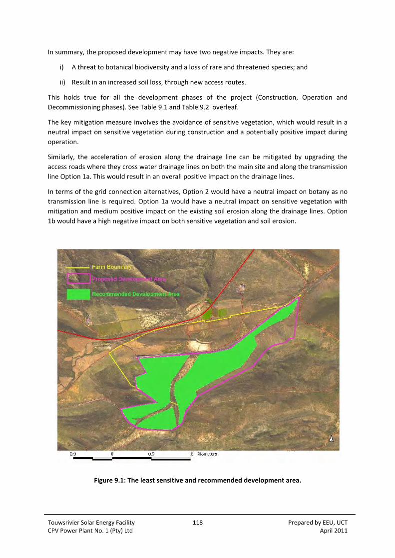
Touwsrivier Solar Energy Facility 118 Prepared by EEU, UCT CPV Power Plant No. 1 (Pty) Ltd April 2011
In summary, the proposed development may have two negative impacts. They are:
i) A threat to botanical biodiversity and a loss of rare and threatened species; and
ii) Result in an increased soil loss, through new access routes.
This holds true for all the development phases of the project (Construction, Operation and
Decommissioning phases). See Table 9.1 and Table 9.2 overleaf.
The key mitigation measure involves the avoidance of sensitive vegetation, which would result in a
neutral impact on sensitive vegetation during construction and a potentially positive impact during
operation.
Similarly, the acceleration of erosion along the drainage line can be mitigated by upgrading the
access roads where they cross water drainage lines on both the main site and along the transmission
line Option 1a. This would result in an overall positive impact on the drainage lines.
In terms of the grid connection alternatives, Option 2 would have a neutral impact on botany as no
transmission line is required. Option 1a would have a neutral impact on sensitive vegetation with
mitigation and medium positive impact on the existing soil erosion along the drainage lines. Option
1b would have a high negative impact on both sensitive vegetation and soil erosion.
Figure 9.1: The least sensitive and recommended development area.

Touwsrivier Solar Energy Facility 119 Prepared by EEU, UCT CPV Power Plant No. 1 (Pty) Ltd April 2011
Table 9.1: Significance of Botanical Impacts
DESCRIPTION
OF THE IMPACT MITIGATION
NATURE / STATUS
EXTENT DURATION INTENSITY PROBABILITY EFFECT ON DECISION
SIGNIFICANCE
CONSTRUCTION
Disturbance of sensitive vegetation
Without mitigation Negative Local Permanent Medium Highly probable High High
With mitigation Neutral Local Temporary Low Highly probable High High
Acceleration of soil erosion along drainage lines
Without mitigation Negative Local Permanent High Highly probable High High
With mitigation Positive Local Temporary Low Probable High High
OPERATION
Disturbance of sensitive vegetation
Without mitigation Negative Local Permanent Medium Highly probable High High
With mitigation Positive Local Temporary Low Probable High High
Acceleration of soil erosion along drainage lines
Without mitigation Negative Local Permanent High Highly probable High High
With mitigation Positive Local Temporary Low Probable High High
DECOMMISSIONING
N/A N/A N/A N/A N/A N/A N/A N/A N/A
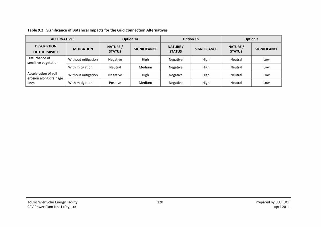
Touwsrivier Solar Energy Facility 120 Prepared by EEU, UCT CPV Power Plant No. 1 (Pty) Ltd April 2011
Table 9.2: Significance of Botanical Impacts for the Grid Connection Alternatives
ALTERNATIVES Option 1a Option 1b Option 2
DESCRIPTION
OF THE IMPACT MITIGATION
NATURE / STATUS
SIGNIFICANCE NATURE / STATUS
SIGNIFICANCE NATURE / STATUS
SIGNIFICANCE
Disturbance of sensitive vegetation
Without mitigation Negative High Negative High Neutral Low
With mitigation Neutral Medium Negative High Neutral Low
Acceleration of soil erosion along drainage lines
Without mitigation Negative High Negative High Neutral Low
With mitigation Positive Medium Negative High Neutral Low

Touwsrivier Solar Energy Facility 121 Prepared by EEU, UCT CPV Power Plant No. 1 (Pty) Ltd April 2011
10 IMPACTS ON FAUNA
The following assessment of potential impacts on fauna has been sourced from the Faunal Impact
Assessment (Coetzee, 2011) attached as Appendix 8.4.
10.1 LOSS OF NATURAL HABITAT
10.1.1 Impact
A potential impact is the loss of natural habitat due to the degree of overlap between the proposed
development and the identified sensitive natural habitats. As shown in the fauna sensitivity analysis,
most of the sensitive vertebrate animal species are restricted largely to the Renosterveld, Succulent
Karoo and drainage line habitats of the affected area.
The boundaries of the proposed development area overlaid over a map showing the habitat
sensitivity of the site in terms of fauna shows that there are some areas of overlap where the
proposed development would have a negative impact on the habitat of the sensitive fauna (see
Figure 10.1). Habitat would be completely lost.
10.1.2 Mitigation
Construction Phase:
Restrict the establishment of all infrastructure to the transformed parts of the site, i.e. old lands, roads, railway line, etc; and
Use preferred transmission line Option 1a.
Operational and Decommissioning Phase:
Not applicable.

Touwsrivier Solar Energy Facility 122 Prepared by EEU, UCT CPV Power Plant No. 1 (Pty) Ltd April 2011
Figure 10.1: Evaluation of Habitat Sensitivity within the Proposed Development Area
10.1.3 Destabilisation of the drainages during construction
10.1.4 Impact
In the fauna sensitivity analysis it was shown that past agricultural transformation of the affected
area as well as injudicious destructive canalisation in drainages had destroyed valuable drainage line
habitat. It is thus possible that with the construction of the solar tracking infrastructure that the
sensitive drainages may be further destabilized or transformed. It has also been shown that these
drainages represent sensitive fauna habitat and that the further loss of drainages habitat should be
avoided.
10.1.5 Mitigation
Construction Phase:
Restrict the establishment of all infrastructure to the transformed parts of the site, i.e. old lands, roads, railway line, etc.
Touwsrivier Solar Energy Facility 123 Prepared by EEU, UCT CPV Power Plant No. 1 (Pty) Ltd April 2011
Construct any necessary vehicular access across any of the drainages with the conservation of the drainage line buffer strip in mind. This would necessitate the minimum of drainage bank disturbance and the minimum natural vegetation disturbance possible.
Maintain a 15 m undisturbed natural buffer strip on both sides of the middle of each drainage line within the affected area.
Operational Phase:
Retain the undisturbed natural buffer strip on both sides of the drainages within the fenced solar tracking infrastructure area.
Decommissioning Phase:
Avoid any disturbance of the drainage lines during the dismantling and removal of infrastructure and materials.
10.2 HABITAT / POPULATION FRAGMENTATION
10.2.1 Impact
Habitat / population fragmentation in terms of the proposed security fence design and placement is
a potential impact. Security fencing around the outer perimeter of the solar tracking infrastructure
area would become a physical barrier for populations of smaller and medium sized vertebrates. This
may result in the fragmentation of important areas of habitat for species such as hares, African
wildcat, mongooses, porcupines, tortoises and certain ground birds. Some of the species that may
be affected include small carnivores with extensive hunting ranges as well as animals with relatively
small ranges such as tortoises. In both cases, fragmentation of natural habitat with impermeable
fencing would certainly have a negative impact on certain small vertebrate populations.
10.2.2 Mitigation
Construction Phase:
Provide a small gap (±150 mm) at ground level, all along the security perimeter fence around the affected area.
Operational Phase:
Maintain the ±150 mm gap at the bottom of the perimeter fence.
Decommissioning Phase:
Gap no longer necessary when the fence is removed and animals can move freely cross the landscape.

Touwsrivier Solar Energy Facility 124 Prepared by EEU, UCT CPV Power Plant No. 1 (Pty) Ltd April 2011
10.3 INCREASE IN BIRD COLLISIONS WITH INFRASTRUCTURE
10.3.1 Impact
There is some potential for larger birds colliding with infrastructure when in flight. This is not a
problem for smaller birds but larger, slow flying birds like blue cranes, white storks, bustards and
larger birds of prey are known to be killed when they fly into physical man‐made barriers, because
they are slow to adjust in mid‐flight (Smallie, 2008).
The problem generally relates to relatively “invisible” infrastructure like cables, power cables and
other “high” wires. The envisaged solar tracking units, buildings, electricity pylons and perimeter
fences are not likely to be a problem for larger birds, because these installations are fairly large and
are thus clearly visible to birds when in flight.
What would cause a problem are power cables spanned between supporting pylons across and near
to the development area. These cables are apparently “invisible” to large flying birds (Smallie,
2008).
The affected area is not a known “flight” path for larger birds, although bustards and blue cranes to
occur in the area.
10.3.2 Mitigation
Construction Phase:
Install effective visibility markers, namely bird “flappers” (diverters) on the entire length of the transmission line Option 1a and on any other power lines in the solar energy facility development area. This should be done in close collaboration with the power management authority;
If the perimeter security fence exceeds 1.8 m in height, install similar markers along the top fence wire to make it more visible;
Maintain a 15 m undisturbed natural buffer strip on both sides of the middle of each drainage line within the affected area; and
The site and transmission line route should be monitored during construction to determine avian mortalities.
Operational Phase:
Maintain power cable and fence visibility markers and replace timeously if damaged by high winds or the sun; and
The site and transmission line route should be monitored at intervals (agreed by the relevant parties) during the operational phase of the project to determine avian mortalities.
Decommissioning Phase:
Improved visibility is obviated by the removal of the fence and other infrastructure.
Maintain power cable visibility markers.

Touwsrivier Solar Energy Facility 125 Prepared by EEU, UCT CPV Power Plant No. 1 (Pty) Ltd April 2011
10.4 BAT (CHIROPTERA) COLLISIONS WITH INFRASTRUCTURE
10.4.1 Impact
There is a possibility that nocturnal microchiroptera (largely insect‐eating bats) may be attracted to
the solar power infrastructure at night by their prey, the flying insects that are attracted by security
lights, which may increase bat collisions with infrastructure. Although bats can generally fly through
complicated lattice structures without collision by means of echo‐location, the possible mass
gatherings where lights would attract insects may result in an increase in collisions.
10.4.2 Mitigation
Construction Phase:
Investigate the use of yellow light rather than white light, because yellow light does not attract flying insects; and
The site and transmission line route should be monitored during construction to determine bat mortalities.
Operational Phase:
Maintain the use of security lighting that has a low attraction for flying insects; and
The site and transmission line route should be monitored at intervals (agreed by the relevant parties) during the operational phase of the project to determine bat mortalities.
Decommissioning Phase:
No longer applicable once infrastructure is removed.
10.5 IMPACT ON RED DATA FAUNA SPECIES
There is the potential for direct or indirect negative impacts on the identified Red Data fauna
species.
10.5.1 Impact on Mammals
Refer to Table 8.2 for a list of possible Red Data species. As the likelihood of the Red Data listed
mammal species occurring within the affected area is based on published distribution and a
knowledge of the habitat requirements of the species concerned and not positive identification, a
lowest risk approach is followed by assuming the Red Data species are in fact present, where the
local conditions conform to their habitat requirements.
The Fynbos golden mole is considered a possibility for the study area, as it is largely restricted to
Fynbos scrub. The mapped distribution includes the study area, presumably in the nearby Fynbos
and possibly Renosterveld habitats. The other mole, the Cape golden mole, is likely to occur in the
study area as it is recorded for Succulent Karoo habitats. Mole hills were observed in both
Renosterveld and Succulent Karoo parts of the study area. It is thus recommended that all
development be restricted to the already transformed areas and that no part of the untransformed
Renosterveld or Succulent Karoo should be disturbed in the interests of maintaining habitat and

Touwsrivier Solar Energy Facility 126 Prepared by EEU, UCT CPV Power Plant No. 1 (Pty) Ltd April 2011
refuge for both Red listed (and other) mole species. The drainage that lies across the study area
must also be retained undisturbed as part of the “natural” habitat (and corridor area) for these
moles.
The three bat species are classed as near threatened. It is unlikely that these bats would be affected
by the physical aspects of the proposed development, as there are no cave or crevasse roosting sites
within the affected area. The potential for roosting sites are all well beyond the boundaries of the
study area in the rock crevasses of the hills. The bats would be able to continue their use of the
study area for aerial feeding and no further mitigation is thus considered necessary for bats.
The white‐tailed rat is considered to be endangered due to large‐scale loss of habitat which includes
Sandy Fynbos and Renosterveld. If this species does occur in the area, its continued existence can be
ensured by retaining most of the natural Renosterveld habitat of the area in an undisturbed
condition. The habitat on site is, however, not considered to be optimal for this species, as the study
site lies on the eastern borderline of this animal’s distribution range. Once again, retaining the
natural Renosterveld and Succulent Karoo in an undisturbed condition may contribute to the
continued survival of the white‐tailed rat if it does occur in the area.
The striped weasel is likely to occur in the affected area and it is considered to be under threat due
to habitat and prey reduction. On the affected area, this species would have adequate habitat in the
unaffected Renosterveld and Succulent Karoo areas. These animals would not be disadvantaged by
the development, if it is restricted to the transformed part of the study area, as the largely rodent
prey of this small carnivore would be little affected, as it largely occurs in areas of natural vegetation
habitat.
In addition to the Red Data species, the mammals in Table 8.3 have recently been listed as having
protected species status in terms of Section 56(1) of the National Environmental Management:
Biodiversity Act (Act 10 of 2004) and this includes the caracal (Caracal caracal), porcupine (Hystrix
africeaustralis) and common duiker (Sylvicapra grimmia).
These species would make use of the natural habitats of the study area and would, locally thus not
be negatively impacted by the proposed development of the transformed habitats.
The preferred transmission line alternative Option 1a is unlikely to have any significant permanent
impact on any of the local mammal populations.
10.5.2 Impact on Birds
Of the 71 bird species predicted to occur on the study area, only 2 are listed as Red Data species
(Barnes, 2000). These are the blue crane (classed as vulnerable) and the black harrier (classed as
near threatened).
The black harrier occurs over Fynbos, Grassland and Karoo and is concentrated near to wheat fields
and other cultivation where its rodent prey may be abundant. The cultivated part of the study area
is mostly fallow and is therefore less productive from a seed‐eating rodent point of view. It is thus
unlikely that black harriers, if they do occur in the area, are dependent on the rodents of these old
lands. Preserving the natural and (relatively) undisturbed parts of the study area (including the
drainage line) would help to continue provide smaller predatory birds with natural prey. The study
area is not considered to be optimal black harrier habitat and the loss of transformed areas to the
proposed development is thus not considered to be problematic. There are also numerous other

Touwsrivier Solar Energy Facility 127 Prepared by EEU, UCT CPV Power Plant No. 1 (Pty) Ltd April 2011
productive cultivated lands in the district which can be used as hunting habitat by the black harriers
if they do occur in the general area.
Blue cranes were observed on the old lands of the study area despite the fact that Succulent Karoo
habitats are not considered to be optimal for the species. The study area lies at the northern edge
of their south‐eastern Cape distribution. In the Fynbos region, blue cranes are restricted to
intensively cultivated croplands. On the study area, the proposal is that these cultivated croplands
be used for the proposed development rather than the disturbance of any natural vegetation. This is
due to the small sedentary rare animals described in this report and the special plants described by
Vlok (2010 and 2011). The blue crane is a large mobile animal that is able to move over great
distances. It is thus suggested that the localised loss of a few small croplands to a solar power
installation would be less of a problem for the “local” blue cranes that can move away to other
nearby lands than the loss of natural Renosterveld and Succulent Karoo for the rare small localised
fauna and plants.
The two Red Data listed bird species are thus unlikely to be negatively impacted by the use of the
transformed part of the study area for the proposed development.
In addition to the Red Data bird species, the endemic or near endemic bird species of the study area
should also be considered important because these species are endemic to the Subregion, which is
thus entirely responsible for their global survival. The endemic or near‐endemic bird species which
are predicted to occur within the study area are given in Table 8.4.
With the possible exception of the jackal buzzard, these endemic and near endemic birds are
associated with the natural Renosterveld, Succulent Karoo and drainage line vegetation of the study
area. The long term protection of these natural parts of the study area would thus assist with the
local conservation of these endemics and near endemics. This is a further motivation to restrict the
proposed development to the already transformed area.
10.5.3 Mitigation
Construction Phase:
Retain the areas of natural Succulent Karoo, Renosterveld and drainage line habitat undisturbed for the conservation of habitat and connectivity of habitat for the Red Data listed species.
10.6 DISPLACEMENT OF FAUNA DURING CONSTRUCTION
10.6.1 Impact
Certain local fauna species may become displaced as a result of the noise and physical disturbance
that would be associated with the construction phase of the development. This displacement can be
considered as temporary (the construction phase is estimated to be ± 24 months) with most fauna
moving back into the area or again using the area after the ending of construction disturbance.
Larger mammals such as grey rhebok and steenbok that currently make use of the transformed area
(per sobs at the study site) would be permanently displaced due to the establishment of a perimeter
security fence. Smaller fauna (hares, porcupines, mongooses, etc) would be able to move into the
developed area due to the “permeable” fence mitigation. Reptiles, rodents and smaller birds would
Touwsrivier Solar Energy Facility 128 Prepared by EEU, UCT CPV Power Plant No. 1 (Pty) Ltd April 2011
become spatially displaced, but would quickly reoccupy the natural parts of the developed site,
particularly with the implementation of the recommended rehabilitation efforts.
Permanent displacement of any particular species should not have any lasting negative impact on
the survival of the population of that species, because of the extensive availability of smaller and
identical habitat immediately adjacent to the affected area.
(This excludes the Red Data listed fauna which should not be displaced from their natural habitat in
the Renosterveld, Succulent Karoo and drainage habitats. Transmission line alternative Option 1a
largely avoids these more sensitive habitats).
10.6.2 Mitigation
Construction Phase:
Restrict all physical construction disturbance to the approved development footprint so that surrounding natural/other habitat can serve as an undisturbed (temporary or permanent) refuge for displaced fauna.
Ensure that construction workers/staff understand that no form of wildlife poaching, collecting or other form of disturbance can be permitted on the construction site or the adjacent areas.
10.7 FAUNA IMPACT AUDIT
It is proposed that the recommendations made in this report to mitigate possible fauna impact,
should be incorporated into the brief of the Environmental Control Officer (ECO). No specific fauna
knowledge is required, as the recommendations relate mostly to natural habitat exclusion and
protection, fence specifications and transmission line cable visibility improvement.
The ECO must ensure that the areas of exclusion (natural habitat) are clearly marked prior to
commencement with construction.
The ECO should also regularly check that these recommendations are fully implemented during the
construction phase.
The ECO should monitor the site and transmission line route during construction and at intervals
(agreed by the relevant parties) during the operational phase of the project to determine avian and
other faunal mortalities.
10.8 ALERNATIVE DEVELOPMENT OPTIONS
The alternative development options consist of:
The no‐go/maintain the status quo option;
Develop the Touwsrivier solar energy facility as proposed;
The use of transmission line Option 1a and not 1b.

Touwsrivier Solar Energy Facility 129 Prepared by EEU, UCT CPV Power Plant No. 1 (Pty) Ltd April 2011
Transmission line Options 1a and 1b were compared in terms of fauna habitat and the sensitivity of
each was estimated to be low. However, the botanical survey indicated that Option 1a was
preferred over 1b due to the predominantly succulent vegetation type of Option 1b which is also
more sensitive. (See description of habitats).
The potential impacts of the proposed development have already been assessed and it can be
concluded that, with the recommended mitigatory measures in place, the development of the solar
energy facility will not have any lasting or permanent negative effect on the vertebrate fauna of the
study area. The recommended primary mitigation is to restrict all development of the project to the
already agriculturally transformed area of old lands and the preferred transmission line Option 1a. If
any part of the proposed development should encroach on any part of the natural Renosterveld,
Succulent Karoo or drainage line habitat, then the potential for negative impact on vertebrate fauna
will increase sharply.
In the no‐go option, there are simply no impacts and no need for any mitigation. This option is not
necessarily the best option for the natural environment and the fauna, as has already been shown in
the botanical baseline (Section 8.6) in which the habitats area described and the recent physical
disturbance of the drainage lines is highlighted. Severe habitat degradation has occurred as a result
of the transformation and the inadequate provision for increased erosive runoff from the lands.
Similarly, the area of Succulent Karoo was found to be severely overgrazed. It would thus not be
completely correct to assume that the “no‐go” option is preferable in terms of fauna and fauna
habitat.
10.9 POTENTIAL CUMULATIVE IMPACTS
10.9.1 Overgrazing of natural habitat adjacent to the study area
The complete exclusion of all areas of natural Renosterveld, Succulent Karoo and drainage lines
within the study area may be seen to be an unnecessarily cautious recommendation. It may be
suggested that there is sufficient alternative habitat “outside” the study area for small fauna
conservation.
It is, however, possible that these “outside” areas could become severely overgrazed and eroded, a
condition that is by no means unusual in the general area. This would result in a cumulative impact,
i.e.: relying on the local conservation of small sensitive fauna in adjacent (outside) natural veld and
then “losing” this conservation value due to later injudicious land use. This is why it is considered
necessary to retain the areas of natural habitat, undisturbed, within the study are, where
overgrazing can be avoided. The recommended mitigations would help to prevent this cumulative
impact.
10.9.2 Severe soil erosion downstream
The protection of drainage lines across the study areas with a buffer strip on each side may be
considered to be an excessive precautionary measure. It is, however, critical that these drainages
become stabilized and remain stabilized to help prevent the severe soil erosion that could occur
during severe rainfall events. If the drainages are not stabilized and protected, the cumulative
impact is that the banks would erode during flooding and the lower parts of the project would
become flooded and damaged. The recommended mitigatory measures would help to prevent or
moderate the potential cumulative impact.
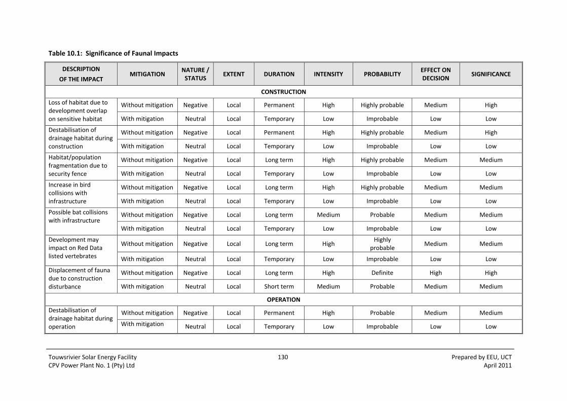
Touwsrivier Solar Energy Facility 130 Prepared by EEU, UCT CPV Power Plant No. 1 (Pty) Ltd April 2011
Table 10.1: Significance of Faunal Impacts
DESCRIPTION
OF THE IMPACT MITIGATION
NATURE / STATUS
EXTENT DURATION INTENSITY PROBABILITY EFFECT ON DECISION
SIGNIFICANCE
CONSTRUCTION
Loss of habitat due to development overlap on sensitive habitat
Without mitigation Negative Local Permanent High Highly probable Medium High
With mitigation Neutral Local Temporary Low Improbable Low Low
Destabilisation of drainage habitat during construction
Without mitigation Negative Local Permanent High Highly probable Medium High
With mitigation Neutral Local Temporary Low Improbable Low Low
Habitat/population fragmentation due to security fence
Without mitigation Negative Local Long term High Highly probable Medium Medium
With mitigation Neutral Local Temporary Low Improbable Low Low
Increase in bird collisions with infrastructure
Without mitigation Negative Local Long term High Highly probable Medium Medium
With mitigation Neutral Local Temporary Low Improbable Low Low
Possible bat collisions with infrastructure
Without mitigation Negative Local Long term Medium Probable Medium Medium
With mitigation Neutral Local Temporary Low Improbable Low Low
Development may impact on Red Data listed vertebrates
Without mitigation Negative Local Long term High Highly
probable Medium Medium
With mitigation Neutral Local Temporary Low Improbable Low Low
Displacement of fauna due to construction disturbance
Without mitigation Negative Local Long term High Definite High High
With mitigation Neutral Local Short term Medium Probable Medium Medium
OPERATION
Destabilisation of drainage habitat during operation
Without mitigation Negative Local Permanent High Probable Medium Medium
With mitigation Neutral Local Temporary Low Improbable Low Low

Touwsrivier Solar Energy Facility 131 Prepared by EEU, UCT CPV Power Plant No. 1 (Pty) Ltd April 2011
DESCRIPTION
OF THE IMPACT MITIGATION
NATURE / STATUS
EXTENT DURATION INTENSITY PROBABILITY EFFECT ON DECISION
SIGNIFICANCE
Habitat/population fragmentation due to security fence
Without mitigation Negative Local Long term High Highly
probable Medium Medium
With mitigation Neutral Local Temporary Low Improbable Low Low
Increase in bird collisions with infrastructure
Without mitigation Negative Local Long term High Highly
probable Medium Medium
With mitigation Neutral Local Temporary Low Improbable Low Low
Possible bat collisions with infrastructure
Without mitigation Negative Local Long term Medium Probable Medium Medium
With mitigation Neutral Local Temporary Low Improbable Low Low
Development may impact on Red Data listed vertebrates
Without mitigation Negative Local Long term High Highly
probable Medium Medium
With mitigation Neutral Local Temporary Low Improbable Low Low
DECOMMISSIONING
Destabilisation of drainage habitat during decommissioning
Without mitigation Negative Local Permanent High Probable Medium Medium
With mitigation Neutral Local Temporary Low Improbable Low Low
Development may impact on Red Data listed vertebrates
Without mitigation Negative Local Long term High Highly
probable Medium Medium
With mitigation Neutral Local Temporary Low Improbable Low Low
Displacement of fauna due to construction disturbance
Without mitigation Negative Local Long term High Definite High High
With mitigation Neutral Local Temporary Medium Probable Medium Medium

Touwsrivier Solar Energy Facility 132 Prepared by EEU, UCT CPV Power Plant No. 1 (Pty) Ltd April 2011

Touwsrivier Solar Energy Facility 133 Prepared by EEU, UCT CPV Power Plant No. 1 (Pty) Ltd April 2011
11 SOCIAL IMPACTS
The Social Impact Assessment in Appendix 8.5 (Barbour and van der Merwe, 2011) sets out the
potential social impacts and respective mitigation measures.
11.1 POLICY AND PLANNING ISSUES
11.1.1 Energy policy
The development of renewable energy in South Africa is supported at both national and provincial
(Western Cape) levels. In this regard, the National White Paper on Renewable Energy (2003) has set
a target of 10 000 GWh (0.8 Mtoe) renewable energy contribution to final energy consumption by
2013.
Similarly, the White Paper on Sustainable Energy for the Western Cape (2008) sets targets for both
source replacement (15% of energy consumption ‐ against 2006 values ‐ from renewable sources by
2014) and for associated emission reductions (10% reduction ‐ against 2000 values ‐ by 2014). The
2009 Provincial Spatial Development Framework (PSDF) recommends an even more ambitious target
of 25% from renewable energy by 2020.
Relevance to the Project
The proposed Project has the potential to provide up to 50 MW (installed capacity) of solar‐
generated energy to the national grid, and would therefore make a contribution to achieving the
stated national and provincial energy principles and associated targets. Pending authorisation and
licensing, the Project would become operational in 2011‐12. The relevant energy policy frameworks
therefore support the proposed development.
11.1.2 Site related aspects
The Western Cape Regional Methodology for Wind Energy Site Selection (2006) and the Provincial
Spatial Development Framework (PSDF) (2009) make reference to the following siting principles:
Large (wind energy facility) projects should be spaced at least 30‐50 km apart (Regional Methodology);
Preference should be given to disturbed rural landscapes, particularly vertically disturbed ones (Regional Methodology);
Siting should be mindful of potential impacts on touristic and wilderness visual and sense of place values (Regional Methodology);
(Wind energy facilities) should be sited in locations where they have the least potential visual impact (PSDF); and
New transmission lines should follow existing transport or transmission line corridors in as far as possible, and point‐to‐point cross‐country routes should be avoided (PSDF).
In this regard, findings with regard to the Project proposal indicate that:
In as far as could be ascertained, two other renewable energy facilities are proposed in the Touwsrivier area, namely the Konstabel facility (±22 km east of the Touwsrivier site, along
Touwsrivier Solar Energy Facility 134 Prepared by EEU, UCT CPV Power Plant No. 1 (Pty) Ltd April 2011
both sides of the N1), and the Perdekraal facility (slightly to the east of the Touwsrivier site, but set back 25 km north of the N1). Given the relatively large distances involved, coupled to the low profile (>7 m above ground level) of the proposed Touwsrivier Solar Energy Facility, cumulative impacts are not likely to be significant;
The proposed site is horizontally and vertically disturbed. Horizontal disturbances includes old fields, spoil heaps, decommissioned (railway tunnel) and operational Transnet infrastructure (Cape Town‐Pretoria line, associated servitude road and a substation). Vertical disturbances include a 66 kV Eskom line which traverses the site. In addition, the N1 and a Telkom line are located ±1 km to the north of the site;
The landscape context may be described as open, largely undeveloped rural landscape, consisting of broken terrain, located within accessible distance from the City of Cape Town (CCT), at the gateway to the Karoo. The landscape is, however, traversed by the N1, and a number of farmsteads, farm buildings and a scattering of irrigated fields are located directly along the N1 near the proposed site.
Dedicated tourist flows into the study area are currently limited, and largely linked to the Aquila Private Nature Reserve (±5 km to the north of the proposed site). However, a number of private conservation and wilderness/ hunting‐orientated operations have recently become established in the study area;
The proposed site is located ±1 km south of the N1. The N1 constitutes the major road link between the CCT and Boland areas, and Gauteng to the north, and consequently carries major traffic (including tourist) flows. The site is also traversed by the Cape Town‐Pretoria rail line, which carries passenger traffic, including the prestigious Blue Train. Potential exposure of the site to receptors is therefore significant. On the other hand, the site is located in a sparsely populated rural area. The contained scale of the facility (<215 ha), low height of tracker units (±4‐5 m), and screening provided by the broken topography mean that, with the notable exception of Hugo’s Nek farm located to the north of the N1, the facility would be largely screened from adjacent farmsteads and properties; and
Of the three grid connection alternatives, only two of these (Option. 1a and 1b) would require additional transmission lines to be constructed. The Option 1b alignment (±7 km) is proposed to run parallel to an existing 66 kV line and railway infrastructure, and would therefore conform to the relevant PSDF policy directive. Option 1a, the preferred alternative, would not follow existing transport or transmission line corridors. However, the proposed distance (±5 km) is short, and the proposed alignment is well‐screened from the N1 and other significant receptor points.
Relevance to the Project
With the exception of potential visual impacts on a short section of the N1, a short section of the
Cape Town Pretoria railway line and one adjacent property, the proposed site appears to conform to
the key siting principles contained in the Regional Methodology and PDSF. In addition, the potential
visibility of the Project from the N1 and railway line does not necessarily constitute a negative
impact. In this regard, a number of interviewees, including the BVM Tourism Development Officer,
indicated that the facility had the potential to become a landmark, especially for long‐distance
travellers. It should further be noted that, unlike with commercial‐scale wind energy facilities, the
visual impacts associated with the proposed Project would be concentrated due to the contained
scale and low height of the facility, as well as the generally short viewing distances created by the
broken terrain. From a locational point of view, the relevant provincial policy frameworks therefore
largely support the proposed Project site.

Touwsrivier Solar Energy Facility 135 Prepared by EEU, UCT CPV Power Plant No. 1 (Pty) Ltd April 2011
11.1.3 Local level development
A review of the BVM 2007‐2012 IDP indicates that unemployment and poverty levels in the region
are high, while education and skills levels are very low. Addressing HIV/ Aids and alcohol and drug
abuse were identified as significant challenges.
The 2008 BVM Long Term Growth and Economic Development Strategy (LTGEDS) highlights the
BVM’s dependence on and vulnerability to the primary agricultural sector. A number of
diversification strategies are identified, including eco‐tourism. In this regard, the BVM’s relative
proximity to the CCT and Boland areas coupled with the access provided by the N1, are identified as
key competitive advantages.
The 2006 BVM SDF focuses mainly on urban areas. The document is a “broad‐brush” approach to
bioregional planning, and is currently in the process of being supplemented by a finer‐scaled SDP
land use‐category based mapping exercise. The coarse‐grained land use map contained in the SDF
indicates that the proposed site and surrounding properties are designated for “extensive
agricultural” use. The SDF emphasises the important role of the N1 as mobility spine linking the
major towns in the BVM to one another, and the BVM to outside areas.
Both the LTGEDS and SDF indicate that the town of Touwsrivier is struggling economically, as
evidenced by the high unemployment rate of around 50%. Both documents are of the opinion that
the creation of sustainable local economic development and job creation opportunities for
Touwsrivier must be seen as one of the priorities of the BVM. Tourism development and the
encouragement of private investment, which could foster sustainable employment creation, are
identified as feasible development strategies.
Relevance to the Project
Interviews with key BVM officials have indicated enthusiastic support for the project (pers comm,
Pedro, Januarie, January, 2010). The potential of the project to make a meaningful long‐term impact
in terms of sustainable employment creation, skills training and stimulating local spending in
Touwsrivier, are regarded as valuable potential opportunities.
The BVM Head Planner has, however, raised concern regarding potential visual impacts, specifically
the stretch along the N1 from which the facility would potentially be visible, but also in terms of
potential impacts on the “wilderness” sense of place of the area. The commissioning of a VIA and the
implementation of mitigation measures (e.g. vegetational screening) were recommended (pers
comm, Hartzenberg, 2010). A discussion of the findings and conclusions of the VIA are presented
under Section 12.3.5 below.
11.2 SOCIAL IMPACTS ASSOCIATED WITH THE CONSTRUCTION PHASE
The key social issues associated with the construction phase are the following:
Potential positive impacts
Creation of employment and business opportunities, and opportunity for skills development and on‐site training.
Touwsrivier Solar Energy Facility 136 Prepared by EEU, UCT CPV Power Plant No. 1 (Pty) Ltd April 2011
Potential negative impacts
Impacts associated with the presence of construction workers on local communities;
Influx of job seekers;
Increased risks to stock, crops, grazing and farming infrastructure associated with the presence of construction workers;
Loss of agricultural land associated with construction related activities.
11.2.1 Creation of local employment, training, and business opportunities
The total capital expenditure associated with the project is estimated to be in the region of R500‐
800 million (current value). However, the percentage of this total that would accrue to South African
companies is unclear. The work associated with the construction phase would be undertaken by
contractors and would include the establishment of access roads and services, the assembly and
erection of the tracker units, and the construction of the internal substation.
Employment
Information provided by CPV Power Plant No. 1 (Pty) Ltd indicates that the project would provide
±250 direct employment opportunities over a period of ±24‐27 months (2 years+). The approach to
the construction phase would involve the establishment of sections, which would be rolled out over
the 24‐27 month period. The approach would effectively result in a single, uninterrupted
construction phase. This approach would also ensure that the majority of the construction workers
would be required throughout the entire construction period, thereby maximising the potential
employment opportunities.
In terms of skills required, approximately 22.5% of the employment opportunities would be available
to skilled personnel (engineers, electricians, mechanics, skilled machine drivers, management and
supervisory), 22.5% to semi‐skilled personnel (drivers, equipment operators), and 55% to low skilled
personnel (construction labourers, security staff). The developer estimates the associated total wage
bill at ±R90 million for the entire construction period, or approximately R45 million per annum
(assuming 24 month construction period). Potential benefits to the local economy would be
confined to the construction period (±24‐27 months).
CPV Power Plant No. 1 (Pty) Ltd has indicated that it intends making preferential use of local
(Touwsrivier) labour in as far as possible. In this regard, a local recruitment target of up to 70% has
been set. As was indicated in Section 6.4 and Section 8.7.4, unemployment levels in Touwsrivier are
extremely high (>50%), and the creation of local employment opportunities has been identified as a
key priority for the BVM (SDF, LTGEDS)
Training
CPV Power Plant No. 1 (Pty) Ltd has indicated a commitment to meaningful skills training. Given the
low skills levels in the Touwsrivier community, the implementation of a skills training programme is
regarded as crucial if the stated recruitment target (70%) is to be met or approached to any
meaningful extent.
Touwsrivier Solar Energy Facility 137 Prepared by EEU, UCT CPV Power Plant No. 1 (Pty) Ltd April 2011
Experience from other projects has shown that civils works are typically outsourced to contractors
and that these contractors typically prefer to make use of their own skilled and semi‐skilled staff.
Therefore, in order to meet the 70% stated employment target CPV Power Plant No. 1 (Pty) Ltd
would need to contractually require contractors to employ locals from Touwsrivier. However, unless
a skills‐training programme is implemented the chances of meeting this target may be compromised.
In addition, it safe to assume that the majority of direct employment opportunities for members of
the Touwsrivier community would be limited to some semi‐skilled and low skilled opportunities
(±150‐200).
Business opportunities
The non‐component related expenditure (unquantified) during the construction phase would create
business opportunities for the regional and local economy. However, given the technical nature of
the project, and the high import content associated with solar technology, the opportunities for the
local economy are likely to be limited to the local service industry. The regional civils sector may
benefit from contracts awarded to operators based in Worcester. Some opportunities may also
accrue to the regional transport sector (movement of equipment and components onto site).
Further opportunities may exist in the daily transport of staff to and from site, the provision of after‐
hours site security, and catering for personnel on‐site.
A number of the high skill/managerial workers are likely to reside in the study area, most likely in
Touwsrivier, De Doorns or on nearby farms. This would create opportunities for local hotels, B&Bs,
guest farms and people who want to rent out their houses. The injection of income into the area in
the form of rental for accommodation and wages would create opportunities for local businesses
(e.g. retail) in the study area. The hospitality industry in the local towns is also likely to benefit from
the provision of accommodation and meals for professionals (namely engineers, quantity surveyors,
project managers, product representatives) and other (non construction) personnel involved on the
project. Experience from other large construction projects indicates that the potential opportunities
are not limited to on‐site construction workers but also to consultants and product representatives
associated with the project.
Given the stated 70% preferred local recruitment target, it may further be expected that semi‐skilled
and low‐skilled workers would spend a significant portion of their wages in local and regional towns
such as Touwsrivier and Worcester (±24‐27 month period).
Assessment of No‐Go option
There is no impact, as the current status quo would be maintained. The potential employment and
economic benefits associated with the construction of the proposed Project would however be
forgone. The potential opportunity costs in terms of local capital expenditure, employment, skills
development and opportunities for local business are therefore regarded as a negative. Potential
opportunity costs would be greatest with regards to local employment provision and opportunities
for the local service sector.

Touwsrivier Solar Energy Facility 138 Prepared by EEU, UCT CPV Power Plant No. 1 (Pty) Ltd April 2011
Table 11.1: Assessment of local employment, training and business opportunities
Nature: Creation of local employment, training and business opportunities during the construction phase
Without Mitigation With Enhancement
Status Positive Positive
Extent Local,
District
Local,
District
Duration Short term Short term, but implementation of effective and meaningful skills training programmes may equip workers with long term portable skills
Intensity Medium (linked to duration) Medium (linked to duration)
Probability Probable Highly probable
Significance on decision‐making
Low‐Medium Medium
Can impact be enhanced? Yes (see below)
Cumulative impacts: Opportunity to up‐grade and improve portable skills levels in the area.
Recommended enhancement measures
In order to enhance local employment and business opportunities associated with the construction
phase the following measures should be implemented:
Employment
Where reasonable and practical, CPV Power Plant No. 1 (Pty) Ltd should seek to appoint BVM‐based contractors;
CPV Power Plant No. 1 (Pty) Ltd should make it a requirement for contractors to implement a ‘locals first’ policy, especially for semi and low‐skilled job categories. This would be required in order to meet the 70% target for local labour;
Prior to commencement of the construction phase, CPV Power Plant No. 1 (Pty) Ltd should meet with representatives from the BVM, including the Ward 1 (Touwsrivier) Councillor, in order to establish the existence of skills and unemployment databases for the relevant municipal areas. If such databases exist, they should be made available to the appointed contractors. If not, a mechanism for establishing a database should be explored without creating undue community expectations;
Prior to commencement of the construction phase, CPV Power Plant No. 1 (Pty) Ltd should meet with representatives of local organised commercial agriculture to ensure that the recruitment of labour for the construction phase does not result in losses of skilled agricultural workers to the construction project;
The local authorities, community representatives and organisations on the interested and affected party database should be informed by CPV Power Plant No. 1 (Pty) Ltd of the final decision regarding the project and the potential job opportunities for locals and the employment procedures which CPV Power Plant No. 1 (Pty) Ltd intends to implement during the construction phase;

Touwsrivier Solar Energy Facility 139 Prepared by EEU, UCT CPV Power Plant No. 1 (Pty) Ltd April 2011
Training and skills development programmes for locals should be initiated prior to the initiation of the construction phase. This would also be required in order to meet the 70% local employment target set by CPV Power Plant No. 1 (Pty) Ltd.
Business
CPV Power Plant No. 1 (Pty) Ltd should develop a database of local and regional companies, specifically Broad‐based Economic Empowerment (BEE) companies which qualify as potential service providers (e.g. construction companies, catering companies, waste collection companies, security companies etc.) prior to the commencement of the tender process for construction contractors. These companies should be notified of the tender process and invited to bid for project‐related work;
Where possible, CPV Power Plant No. 1 (Pty) Ltd should assist local BEE companies to complete and submit the required tender forms and associated information;
The BVM, in conjunction with representatives from the local hospitality and retail industries, should identify strategies aimed at maximising the potential benefits associated with the project.
Note that while preference to local employees and companies is recommended, it is recognised that
a competitive tender process may not guarantee the employment of local labour for the
construction phase.
11.2.2 Impact of construction workers on local communities
The presence of construction workers poses a potential risk to family structures and social networks.
While the presence of construction workers does not in itself constitute a social impact, the manner
in which construction workers conduct themselves can impact on local communities. The most
significant negative impact is associated with the disruption of existing family structures and social
networks. This risk is linked to potentially risky behaviour, mainly of male construction workers,
including:
An increase in alcohol and drug use;
An increase in crime levels;
The loss of girlfriends and or wives to construction workers;
An increase in teenage and unwanted pregnancies;
An increase in prostitution;
An increase in sexually transmitted diseases (STDs), including HIV.
Potentially affected receptor communities are constituted by the rural community of farm labourers
on farms in the vicinity of the site, and by the urban Touwsrivier community.
With regard to the rural farm labourer community, the findings of this study indicate that the
proposed site is located in a sparsely populated rural area. Tenured labour appears to be the
exception on adjacent farms, and overall numbers are small. CPV Power Plant No. 1 (Pty) Ltd has
indicated that no construction camp (for labour accommodation) would be established on the site.
The potential for adverse impacts on the relevant rural community is therefore not rated as
significant.
Touwsrivier Solar Energy Facility 140 Prepared by EEU, UCT CPV Power Plant No. 1 (Pty) Ltd April 2011
With regard to urban Touwsrivier, provided that the stated 70% local recruitment target is met or
meaningfully approached, the bulk of construction workers would be from the community itself.
Given existing skills levels, the bulk of this figure is likely to be represented by semi‐ and low‐skilled
workers. In this regard, experience has shown that the potential social impacts associated with
construction workers are typically associated with low‐skilled workers and not the more skilled
workers. The fact that the bulk of low skilled workers would potentially be from the local community
would therefore serve to neutralise potential impacts. Any remaining fraction of workers who are
not from Touwsrivier are unlikely to pose a significant risk to the local community.
Given the proximity of the site to Worcester (±80 km), it is likely that civils contractors from
Worcester would be appointed. If this is the case then it would also be relatively easy to transport
workers who reside in Worcester to and from site on a daily basis. A number of non‐local workers
may therefore choose to commute to and from site on a daily basis.
In addition, due to the relative proximity of the study area to other potential labour sending areas
(City of Cape Town, Boland) the majority of workers who do not come from Touwsrivier are likely to
be able to go home over weekends. As a result the potential impacts of construction workers on
local communities are not likely to represent a significant issue.
Table 11.2: Assessment of potential impacts of construction workers on local communities
Nature: Potential impacts on family structures and social networks associated with the presence of construction workers
Without Mitigation With Mitigation
Status Negative Negative
Extent Local Local
Duration Short term Short term
Intensity Low‐Medium Low
Probability Probable Improbable
Significance on decision‐making Low Low
Can impact be mitigated? Yes (see below)
Cumulative impacts:
Impacts on family and community relations that may, in some cases, persist for a long period of time. Where unplanned / unwanted pregnancies occur, or members of the community are infected by an STD, specifically HIV. These impacts may be permanent and have long term to permanent cumulative impacts on the affected individuals and/or their families and the community.
Assessment of No‐Go option
Potential risks to family structures and social networks of local urban communities would be
avoided. On the other hand, potential positive impacts on the local economy associated with the
additional spending by construction workers would be lost.
Recommended mitigation measures
The potential risks associated with construction workers can be mitigated:

Touwsrivier Solar Energy Facility 141 Prepared by EEU, UCT CPV Power Plant No. 1 (Pty) Ltd April 2011
Mitigation measures listed under Section 11.2.1 apply;
CPV Power Plant No. 1 (Pty) Ltd should consider the establishment of a Monitoring Forum (MF) in order to monitor the construction phase and the implementation of the recommended mitigation measures. The MF should be established before the construction phase commences, and should include key stakeholders, including representatives from local communities, local BVM Councillors, farmers and the contractor(s). The MF should also be briefed on the potential risks to the local community associated with construction workers;
CPV Power Plant No. 1 (Pty) Ltd and the contractor(s) should, in consultation with representatives from the MF, develop a code of conduct for the construction phase. The code should identify which types of behaviour and activities are not acceptable. Construction workers in breach of the code should be dismissed. All dismissals must comply with the South African labour legislation;
CPV Power Plant No. 1 (Pty) Ltd and the contractor should implement an HIV/AIDS awareness programme for all construction workers at the outset of the construction phase;
The movement of construction workers on and off the site should be closely managed and monitored by the contractors. In this regard the contractors should be responsible for making the necessary arrangements for transporting workers to and from site over weekends or after hours;
The contractors should make the necessary arrangements for allowing workers from outside the area to return home over weekends and/ or on a regular basis. This would reduce the risk posed to local family structures and social networks
11.2.3 Influx of job seekers to Touwsrivier
As was indicated in Section 6.4, unemployment levels in Touwsrivier are extremely high (>50%), and
the creation of local employment opportunities has been identified as a key priority for the BVM
(SDF, LTGEDS). The findings of the SIA also indicate that the BVM support for the project is largely
motivated by its potential to create employment opportunities for the Touwsrivier community
during both the construction and operational phases. With regard to the construction phase, CPV
Power Plant No. 1 (Pty) Ltd has set a 70% local (Touwsrivier and surrounding area) recruitment
target.
Field interviews indicate that economically motivated in‐migration and subsequent labour stranding
have been a significant problem in parts of the BVM area. While limited economic opportunities
have largely prevented in‐migration into Touwsrivier thus far, opportunities associated with the
agricultural sector in the nearby Hex River Valley have lead to significant in‐migration of people from
the Eastern Cape as well as other African countries (mainly Zimbabwe) over the past few years.
Competition over employment opportunities, housing, etc. resulted in violently xenophobic attacks
in De Doorns in early to mid 2010. A number of prominent informal settlements have also sprung up
outside De Doorns. The subsidised housing backlog for the town is around 6 000 units (pers comm,
Januarie, 2010).
The proposed site is in close proximity to the N1, and in theory would be easily accessible to
outsiders. The relatively short distance to a large pool of unemployed economic refugees in the Hex
River Valley also posed a potential risk of attracting unemployed in‐migrants from the Hex River
Valley to the Touwsrivier. Potential risks include foregoing employment opportunities to members of
the Touwsrivier community, as well as creating potential resentment, animosity and tension.

Touwsrivier Solar Energy Facility 142 Prepared by EEU, UCT CPV Power Plant No. 1 (Pty) Ltd April 2011
Key to mitigating this potential risk would be the rigorous implementation of the stated 70% local
employment recruitment policy. As was argued in Section 11.2.1, this target can only be met or
meaningfully approached if a skills‐training programme is implemented in advance of the
commencement of the construction phase.
Table 11.3: Assessment of potential influx of job seekers
Nature: Influx of job seekers and the pressure that they place on local services and the risk to family structures and social networks
Without Mitigation With Mitigation
Status Negative Negative
Extent Local Local
Duration Indefinite Indefinite
Intensity Low‐Medium Low
Probability Probable Improbable
Significance on decision‐making Low‐medium Low
Can impact be mitigated? Yes (see below)
Cumulative impacts: N/a (Economically in‐migration is currently not an issue in Touwsrivier)
Assessment of No‐Go option
Potential risks of (xenophobic) social tension would be avoided. However, on the other hand, the
potential positive impacts on the local economy would be forgone.
Recommended mitigation measures
The potential risks associated with the influx of job seekers can be mitigated. In this regard the
mitigation measures listed under Sections 11.2.1 and 11.2.2 apply.
11.2.4 Increased risk to stock, crops, pasture, game and farming infrastructure
This risk pertains to both the farm on which the proposed Project is located as well as to operations
on adjacent farms. The presence of and movement of construction workers on and off the site poses
a potential threat to farm infrastructure, such as fences and gates, which may be damaged. Stock
losses may also result from gates being left open and/or fences being damaged. Game may also be
poached. Veld fires also pose a potential risk to crops and pasture, while plastic waste may pose a
risk to livestock and game if ingested.
As was discussed in Section 8.8.5, the portion of Hartebeeskraal (1/36) located to the south of the
N1 is mainly used for the cultivation of irrigated fodder crops (not part of the proposed site) and
limited grazing (also not carried out on the proposed site). The portion of Hartebeeskraal (1/36) on
which the proposed Project is located is currently not used for any productive purposes, and carries
no productive infrastructure (apart from fencing and gates).

Touwsrivier Solar Energy Facility 143 Prepared by EEU, UCT CPV Power Plant No. 1 (Pty) Ltd April 2011
As was discussed in Section 8.8.5, the land uses in the area consist mainly of private conservation/
hunting and limited stock farming (beef cattle), with irrigated crops limited to two operations
located north of the N1, namely Grootstraat (limited fodder and orchards, with a possible expansion
of wine grapes) and Hoogland (table grapes). Steenbok and Grey Rheebuck occur in the area and
isolated sightings of Kudu have also been reported. Stocked game (Red Hartebeest, Ostrich,
Gemsbok, Burchell’s Zebra and Springbok) occur on a number of properties in the area.
Adjacent farms located directly north of the N1 (Grootstraat, Hoogland) are easily accessed off the
N1, while the boundaries of adjacent farms located south of the N1 are generally removed from the
proposed site. Sole access to the site during the construction phase would be off the N1 via a portion
Kleinstraat. The relevant road terminates on Kleinstraat Farm. No other properties would be
traversed. In addition, CPV Power Plant No. 1 (Pty) Ltd has indicated that the site would be fenced
and construction workers would be transported onto and off site on a daily basis. The potential risk
posed by construction workers to Kleinstraat Farm and adjacent properties is therefore not regarded
as significant.
In terms of fire, the local vegetation is prone to fire, especially over the hot, dry summer months. As
a result of edaphic soils and limited rainfall, the fuel load is however limited. In areas of low rainfall
(and associated long revegetation timescales), runaway fires may however lead to significant
erosion, impacting mainly on the grazing resource for stock and game. However, the potential risk
associated with fires can be effectively mitigated. Overall, the risk potential to farms in the study
area is not regarded as a significant issue.
Table 11.4: Assessment of potential risks to stock, crops, grazing, game and infrastructure
Nature: Potential loss of livestock, poaching and damage to farm infrastructure associated with the presence of construction workers on site
Without Mitigation With Mitigation
Status Negative Negative
Extent Local Local
Duration Short term Short term
Intensity Low Low
Probability Improbable‐ Probable Improbable
Significance on decision‐making Low Low
Can impact be mitigated? Yes (see below)
Cumulative impacts: None, provided that losses are adequately compensated for.
Assessment of No‐Go option
There is no impact as the current status quo is maintained. Potential negative impacts on
commercial cropping, stock farming and game would be avoided.
Recommended mitigation measures
The mitigation measures that can be considered in order to address potential risks to livestock, crops
and farm infrastructure include:

Touwsrivier Solar Energy Facility 144 Prepared by EEU, UCT CPV Power Plant No. 1 (Pty) Ltd April 2011
CPV Power Plant No. 1 (Pty) Ltd should consider the establishment of a MF (see above). The MF should include local farmers, and develop a code of conduct for construction workers. This committee should be established prior to commencement of the construction phase. The code of conduct should be signed by CPV Power Plant No. 1 (Pty) Ltd and all relevant contractors prior to the commencement of any on‐site construction activities;
CPV Power Plant No. 1 (Pty) Ltd should hold contractors liable for compensating farmers and communities in full for any stock losses and/or damage to farm infrastructure that can be linked to construction workers. This provision should be contained in the code of conduct to be signed between CPV Power Plant No. 1 (Pty) Ltd, the contractors and neighbouring landowners. The agreement should also cover loses and costs associated with fires caused by construction workers or construction related activities (see below);
The EMP must outline procedures for managing and storing waste (including arrangements for plastic waste etc) on site;
Contractors must ensure that all workers are informed of the conditions contained on the code of conduct at the outset of the construction phase. The consequences of stock theft, poaching and trespassing on adjacent farms should be emphasised;
Contractors must ensure that workers who are found guilty of stealing livestock, poaching and/or damaging farm infrastructure are dismissed and formally charged. This should be contained in the code of conduct. All dismissals must be in accordance with South African labour legislation;
The contractor must ensure that open fires on the site for cooking or heating are not allowed except in designated areas;
The contractor must ensure that construction related activities that pose a potential fire risk, such as welding, are properly managed and are confined to areas where the risk of fires has been reduced. Measures to reduce the risk of fires include clearing working areas and avoiding working in high wind conditions when the risk of fires is greater. In this regard special care should be taken during the high risk dry, windy summer months;
The contractor must provide adequate fire fighting equipment on‐site;
The contractor must provide fire‐fighting training to selected construction staff. This must take place before construction activities commence;
As per the conditions of the code of conduct, in the event of a fire being caused by construction workers and or construction activities, the appointed contractors must compensate farmers for any damage caused to their farms. The contractor should also compensate the fire fighting costs borne by farmers and local authorities.
CPV Power Plant No. 1 (Pty) Ltd should enter into legally binding arrangements with regard to compensation with all relevant property owners prior to the start of construction.
11.2.5 Damage to farm land
Activities such as the establishment of access roads, the movement of heavy vehicles, the
establishment of lay‐down areas and foundations for the tracker units, as well as the establishment
of the substation and permanent building complex would potentially damage topsoil and vegetation.
CPV Power Plant No. 1 (Pty) Ltd has indicated that workers would not be accommodated on site, so
no construction camps would be established.
Construction activities would be limited to a 215 ha area, which is not currently used for any
productive purposes. An assessment of the agricultural potential has been undertaken and has

Touwsrivier Solar Energy Facility 145 Prepared by EEU, UCT CPV Power Plant No. 1 (Pty) Ltd April 2011
concluded that the former cultivated lands of the study area are no longer economically viable (see
Section 8.5 and Appendix 8.2).
The proposed Project is therefore located in an area that has been disturbed by historic farming and
digging operations. The significance of this impact on farming activities and livelihoods on Kleinstraat
Farm is therefore assessed to be of low significance. CPV Power Plant No. 1 (Pty) Ltd has also
indicated that disturbances would be rehabilitated after construction. This would include
revegetation of existing degraded areas as well as areas which have been damaged during
construction activities. Provided successful implementation of rehabilitation measures, the
development may have a localised positive impact.
Table 11.5: Assessment of impact on farmland due to construction related activities
Nature: The activities associated with the construction phase, such as establishment of access/haul roads, the movement of heavy vehicles, establishment of lay‐down areas and foundations for the trackers and substation may potentially damage topsoils and vegetation and impact on grazing resources.
Without Mitigation With Mitigation
Status Negative Positive
Extent Local Local
Duration Long term‐permanent if disturbed areas are not rehabilitated
Very short term if damaged areas are rehabilitated
Intensity Low Low
Probability Probable Improbable‐Probable
Significance on decision‐making Low Low
Can impact be mitigated? Yes (see below)
Cumulative impacts: The proposed site has been impacted upon by historic excavations and (decommissioned) cropping. The potential of accelerated denudation and erosion exists, unless site rehabilitation measures are implemented post construction.
Assessment of No‐Go option
There would be no impact as the current status quo is maintained. Potential negative impacts on
local soils and vegetation would be avoided. However, potential opportunity to rehabilitate existing
degraded and disturbed areas would be foregone.
Recommended mitigation measures
With mitigation, the potential impacts on farming activities and livelihoods as a result of damage to
and loss of farmland are assessed to be of low significance due to the proposed location of the
infrastructure, and the relatively small portions of arable land likely to be affected. In addition the
commitment by CPV Power Plant No. 1 (Pty) Ltd to rehabilitate existing historically disturbed areas
on the site would represent a positive social benefit. Impacts may be further reduced by the
implementation of the following mitigation measures:
Touwsrivier Solar Energy Facility 146 Prepared by EEU, UCT CPV Power Plant No. 1 (Pty) Ltd April 2011
The footprint associated with the construction related activities (access roads, turning circles, construction platforms, workshop etc) should be minimised;
An Environmental Control Officer (ECO) should be appointed to monitor activities undertaken during the construction phase;
All areas disturbed by construction related activities, such as access roads, construction platforms, workshop area etc, should be rehabilitated at the end of the construction phase;
The implementation of a rehabilitation programme should be included in the terms of reference for the contractor/s appointed to establish the Project. The specifications for the rehabilitation programme should be drawn up by the Environmental Consultants appointed to undertake the EIA (i.e. the EEU);
The implementation of the Rehabilitation Programme should be monitored by the ECO;
CPV Power Plant No. 1 (Pty) Ltd should make adequate and timeous provision for covering the costs of eventual decommissioning and rehabilitation of disturbed areas. Establishing an Environmental Rehabilitation Trust Fund may be an option to consider. Such a Trust Fund may be funded by a percentage of the revenue generated from the sale of energy to the national grid over the 25‐30 year operational life of the facility. An alternative funding model may be based on earmarking the income from the eventual sale of recovered materials (e.g. steel, gold, stainless steel, germanium, copper) from decommissioned CPV infrastructure
11.3 SOCIAL IMPACTS ASSOCIATED WITH OPERATIONAL PHASE
The following key social issues are of relevance to the operational phase:
Potential positive impacts
Creation of employment and business opportunities. The operational phase would also create opportunities for skills development and training;
The establishment of infrastructure to generate renewable energy.
Potential negative impacts
Potential impact on tourism;
Impact on farming activities;
The visual impacts and associated impact on sense of place and landscapes.
11.3.1 Creation of employment skills‐development and business opportunities
As discussed in the Section 6.4 the creation of sustainable employment opportunities for the
Touwsrivier community has been identified as one of the key priorities of the BVM in a number of its
key policy documents. Current unemployment in Touwsrivier is estimated at >50%. This figure is
even higher when seasonal unemployment, linked to quiet months in agriculture, is included.
Remittances and social grants therefore represent important sources of income for local residents of
Touwsrivier. The lack of employment opportunities and the perception of no opportunities for
meaningful social advancement and further education have been instrumental in allowing a drug
culture to gain a foothold amongst the local youth.
Touwsrivier Solar Energy Facility 147 Prepared by EEU, UCT CPV Power Plant No. 1 (Pty) Ltd April 2011
Employment
Estimates provided by CPV Power Plant No. 1 (Pty) Ltd indicate that a total compliment of
approximately 100‐140 operational staff would be required for the Project throughout its
operational lifespan (>25 years). It is estimated that approximately 10% of opportunities would be
available to skilled personnel (technicians, plant operators and management), ±20% to semi‐skilled
personnel (administrative, drivers, paramedics), and 70% to low skilled personnel (cleaning, security,
support staff, etc). The wage bill associated with the operational phase is estimated at R25 million
per year (current value), as of the first year of operation at full capacity.
CPV Power Plant No. 1 (Pty) Ltd has indicated that it is committed to the preferential use of local
labour in as far as possible. In this regard, a local recruitment target of 90‐95% has been set,
primarily focusing on Touwsrivier, but also on the Hexrivier Valley and the BVM. Opportunities
associated with the proposed development would therefore be able to make a significant
contribution towards the creation of a number of long‐term stainable employment opportunities.
However, the current low skills and education levels are likely to impact on the ability to attain the
stated target.
Training
CPV Power Plant No. 1 (Pty) Ltd has indicated that it intends retaining construction workers that
show promise for operational phase training and deployment. However, given the requirement of
specialised skills, and that the fact that the solar energy sector in South Africa is relatively new, it
may be necessary to import some of the required operational and maintenance skills from other
parts of South Africa or even overseas, at least initially. The implementation of an appropriate skills‐
training programme during the construction phase would therefore be critical achieving the target of
90‐95% for local employment during the operational phase set by CPV Power Plant No. 1 (Pty) Ltd.
CPV Power Plant No. 1 (Pty) Ltd should also investigate the option of implementing a bursary
programme for promising local matriculants, coupled with internships. This would also create a
mechanism to ensure an ongoing investment in local capacity building.
Business
The potential opportunities for local business would be linked to the wage spent by local residents
who are employed during the operational phase. Given CPV Power Plant No. 1 (Pty) Ltd commitment
to a 90‐95% target for local residents this has the potential to create a sustained capital injection
into the local economy. The benefit would be long term. Some opportunities may also accrue to the
local transport sector, linked to the daily transport of staff to and from site. Further potential
opportunities for local entrepreneurs are linked to the provision of after‐hours site security, and
catering for personnel on‐site.
The local hospitality industry is also likely to benefit from the operational phase. These benefits are
associated with site visits by company staff members and other professionals (engineers, technicians
etc) who are involved in the company and the project but who are not linked to the day‐to‐day
operations.

Touwsrivier Solar Energy Facility 148 Prepared by EEU, UCT CPV Power Plant No. 1 (Pty) Ltd April 2011
Table 11.6: Assessment of employment and business creation opportunities
Nature: Creation of local employment and business opportunities associated with the operational phase
Without Mitigation With Enhancement
Status Positive Positive
Extent Local Local
Duration Long term Long term
Intensity Medium Medium‐High
Probability Probable Highly Probable
Significance on decision‐making Medium Medium‐High
Can impact be mitigated? Yes (see below)
Cumulative impacts: No other similar initiatives are currently proposed for the Touwsrivier area. The provision of a sustainable, stable, long‐term source of income to the local community may contribute towards a significant number of households’ being able to break out of the poverty cycle.
Assessment of No‐Go option
There is no impact, as the current status quo would be maintained. Potential significant employment
and economic benefits associated with the proposed Project would however be forgone. The
potential opportunity costs in terms of local capital expenditure, employment, skills development
and opportunities for local business are therefore regarded as a negative.
Recommended enhancement measures
The enhancement measures listed in Section 11.2.1, i.e. to enhance local employment and business
opportunities during the construction phase, also apply to the operational phase. In addition:
CPV Power Plant No. 1 (Pty) Ltd should implement an ongoing training and skills development programme for locals. The aim of the programme should be to maximise the number of people from local communities and the broader BVM area employed during the operational phase of the project on all technical levels of the project; and
CPV Power Plant No. 1 (Pty) Ltd may also investigate the establishment of a Community Trust. Ideally, such a Trust would need to be set up in consultation with the BRM, and linked to addressing developmental priorities as identified within the BRM IDPs. The revenue for the trust would be derived from the income generated from the sale of energy from the plant. The mitigation measures listed in the report to address the potential negative impacts during the construction phase should also be implemented.
11.3.2 Development of infrastructure for the generation of clean, renewable energy
South Africa currently relies on coal‐powered energy to meet more than 90% of its energy needs. As
a result South Africa is the nineteenth largest per capita producer of carbon emissions in the world,
and Eskom, as an energy utility, has been identified as the world’s second largest producer of carbon
emissions.
The establishment of a clean, renewable energy facility would therefore reduce, albeit minimally,

Touwsrivier Solar Energy Facility 149 Prepared by EEU, UCT CPV Power Plant No. 1 (Pty) Ltd April 2011
South Africa’s reliance on coal‐generated energy and the generation of carbon emissions into the
atmosphere. As discussed in Section 11.1.1, the promotion of renewable energy sources is
supported at national and provincial levels.
The overall contribution of the proposed Project to South Africa’s total energy requirements would
be modest (±50 MW). Furthermore, the current application is not unique. In this regard, a significant
number of renewables (mainly wind energy facilities) developments are currently proposed in the
Western, Eastern Cape and Northern Cape Provinces of South Africa. The potential contribution of
the Touwsrivier facility should therefore be regarded as valuable, but should not be overestimated.
The unique location of the site in proximity to the N1 and to the Cape Town‐Pretoria railway line
provides the ideal opportunity for the project to raise public awareness of renewable energy
projects. An on‐site interpretation centre and electronic billboards along the N1 or railway line
displaying output are potential options to achieve this objective.
Table 11.7: Development of clean, renewable energy infrastructure
Nature: Development of infrastructure to generate clean, renewable energy
Without Mitigation With Mitigation
Status Positive Positive
Extent Local, District, Provincial, National
Local, District, Provincial, National
Duration Long term Long term
Intensity Low‐Medium Low‐Medium
Probability Highly Probable Highly Probable
Significance on decision‐making Medium Medium
Can impact be mitigated? Yes (see below)
Cumulative impacts:
Potential contribution to establishing an economically viable commercial renewables generation sector in the Western Cape and South Africa.
Assessment of No‐Go option
The No‐Development option would represent a lost opportunity for South Africa to supplement its
current energy needs with clean, renewable energy. This would represent a negative opportunity
cost.
Recommended mitigation measures
The establishment of the proposed Project is a mitigation measure in itself. In order to maximise the
benefits of the proposed project, CPV Power Plant No. 1 (Pty) Ltd should:
Use the project to promote and increase the contribution of renewable energy to the national energy supply;

Touwsrivier Solar Energy Facility 150 Prepared by EEU, UCT CPV Power Plant No. 1 (Pty) Ltd April 2011
Implement a skills development and training programme aimed at maximising the number of employment opportunities for local community members; and
Investigate additional opportunities for benefit to the community, such as for instance the creation of a Community Trust.
11.3.3 Potential impacts on tourism
The findings of the SIA indicate that the BVM LTGEDS identifies tourism development as one of the
key growth strategies for the municipality. In this regard the development of the tourism sector in
Touwsrivier has been identified as a key intervention strategy in both the LTGEDS as well as the SDF.
Key potential tourist attractions include the area’s night skies, 4x4 routes, rail history (a possible
steam rail link between De Doorns and Touwsrivier), and a “Karoo‐experience”. The town’s relative
proximity to Cape Town and the Boland is also identified as key opportunity.
At present there are a limited number of tourism destinations in the Touwsrivier area. In this regard
the Touwsrivier Tourism Association was only established recently. While the N1 carries major traffic
and tourism flows through the study area, dedicated tourist inflows are largely associated with
wilderness‐based destinations. Of these, the Aquila Private Nature (±5 km north of the proposed
site) is the best known. A number of other established – e.g. Bijstein and Nadini Private Nature
Reserves – and emerging operations (e.g. Vredefort hunting farm) are also located in the study area.
The Karoo‐1 facility, located ±7 km west of the proposed site, provides a range of accommodation,
conferencing and other facilities. What each of these developments has in common is the
perception of an accessible, yet relatively undeveloped “Karoo wilderness” area. The potential
negative impacts on tourism are associated with the potential visual impact of the proposed Project
on the areas current undeveloped, rural sense of place.
In terms of potential receptors, the proposed site is visible from the N1 to varying degrees along a
section of ±6 km. The BVM Head Planner has identified the potential visual impact on the N1 as an
issue of concern. Visual screening (e.g. tree planting) of the development from the N1 has been
recommended as a potential mitigation measure. However, it should also be noted that the
proposed site is disturbed (spoil heaps, decommissioned fields) and accommodates a railway line, a
66 kV transmission line and a substation. These disturbed areas and the vertical infrastructure on the
site are clearly visible from the N1. The proposed development would therefore not impact on a
pristine, undisturbed natural landscape. In addition, due to the broken terrain, sighting distances are
typically short, unless the facility is viewed from high ground.
The Cape Town‐Pretoria railway line that runs across also accommodates the prestigious Blue Train,
and would be the line for the proposed De Doorns‐Touwsrivier steam train. However, the BVM
Tourism Development Officer has indicated that the visibility of the proposed Project from the
railway line would not necessarily constitute a negative impact. In this regard the proposed Project
may become a landmark, specifically given that the development of commercial‐scale solar energy
facilities are still in their infancy in South Africa (pers comm, Basson, 2010).
In terms of adjacent properties, a number of farms have recently been developed for conservation
and mixed conservation and stock farming. Private and commercial hunting operations have also
been and are in the process of being established on a number of farms in the study area. Owners of
at least two adjacent farms have indicated that they intend to develop small‐scale, upmarket
tourism (accommodation, hiking trails) accommodation on portions of their properties in future.
Specific concerns have been raised by the owners of Hugo’s Nek and Grootstraat Farm with regard

Touwsrivier Solar Energy Facility 151 Prepared by EEU, UCT CPV Power Plant No. 1 (Pty) Ltd April 2011
to the potential visibility of the Project from the relevant portions of their properties. The owner of
Hugo’s Nek Farm also indicated that the potential glare (reflection) from the massed array of panels
was a concern.
The findings of the visual impact assessment (VIA) are discussed under Section 11.3.5, and indicate
that, in terms of receptors, impacts would be limited to the N1, the portion of railway line and
elevated vantage points on Hugo’s Nek and Grootstraat. With the exception of a weekend house on
Hugo’s Nek, the Project would not be visible from any established residential structures on any of
the site‐adjacent properties. The Project would not be visible from the Aquila Nature Reserve.
In terms of potential mitigation measures, the site can be screened from the N1 by planting trees
either along the boundary of the N1 road reserve or closer to the site. The potential visual exposure
of the site from the railway line would however be less easy to screen. However, as indicated above,
the exposure from the railway line may not necessarily constitute a significant issue of concern. The
visibility of the site from elevated portions on Hugo’s Nek and Grootstraat cannot be effectively
screened. However, while this may probably detract from the enjoyment of property of the owner of
Hugo’s Nek (much of which is elevated), who had expressly acquired the property for establishing a
private hunting farm, it should be borne in mind that no tourism employment or other related
opportunities are currently associated with either Hugo’s Nek or Grootstraat. From a social equity
point of view, the potential sustainable long term employment opportunities associated with the
project outweigh potential visual impacts on Hugo’s Nek, which at this stage would mainly affect the
owner’s enjoyment of his property.
Table 11.8: Potential Impacts on tourism
Nature: Potential visual impact of the proposed Project on the areas sense of place and the negative impact on local tourism
Without Mitigation/ Enhancement
With Mitigation/ Enhancement
Status Negative Negative
Extent Local Local
Duration Long term Long term
Intensity Low‐Medium Low
Probability Probable Probable
Significance on decision‐making Low‐Medium Low
Can impact be mitigated? Yes (see below)
Cumulative impacts: No other similar developments currently exist or are being proposed in the study area.

Touwsrivier Solar Energy Facility 152 Prepared by EEU, UCT CPV Power Plant No. 1 (Pty) Ltd April 2011
Assessment of No‐Go option
No‐Development option would avoid the risk of compromising the “wilderness” landscape amenity
in an area located in proximity to a major tourism route (N1). Potential local employment and
associated opportunities would however be foregone.
Recommended mitigation/ enhancement measures
The recommendations contained in the VIA should be implemented;
The option of establishing vegetation to screen the site from the N1 should be investigated;
CPV Power Plant No. 1 (Pty) Ltd should liaise with representatives from the BVM and local tourism representatives to raise awareness of the proposed solar energy facility;
CPV Power Plant No. 1 (Pty) Ltd should consider establishing a renewable energy interpretation centre on the site or in the town of Touwsrivier; and
In order to maximise associated benefits, it is recommended that information be presented in the two main languages of the region, namely English and Afrikaans.
11.3.4 Impact on farming activities
This issue relates to the potential long‐term impact of the Project and associated infrastructure on
existing farming activities, specifically the loss of arable land for crops and grazing. This loss may, in
turn, impact on the viability of operations and the livelihoods of the affected farmers.
As was discussed in Section 8.8.5, the portion of Kleinstraat Farm located to the south of the N1 is
mainly used for the cultivation of irrigated fodder crops (not part of the proposed site) and limited
grazing (also not carried out on the proposed site). The farm portion on which the site is located is
not currently used for any productive purposes, and carries no productive infrastructure (apart from
fencing and gates). Old, abandoned fields on the site were used for the cultivation of cereal crops.
However, the unpredictable and low rainfall constitutes a significant constraint to dry land cropping
in the study area. In addition the natural veld stock carrying capacities for the area are low (<1 small
stock unit/ ha). An assessment of the agricultural potential has been undertaken and has concluded
that the former cultivated lands of the study area are no longer economically viable (see Section 8.5
and Appendix 8.2). The establishment of the proposed Project and associated loss of land would
therefore not impact negatively on the livelihoods of the owners of Kleinstraat Farm. The potential
impact on current and potential future farming activities is therefore not rated as a significant issue.
Assessment of No‐Go option
There is no impact as the current status quo is maintained.
Recommended mitigation measures
Mitigation measures outlined in Section 11.2.5 apply.
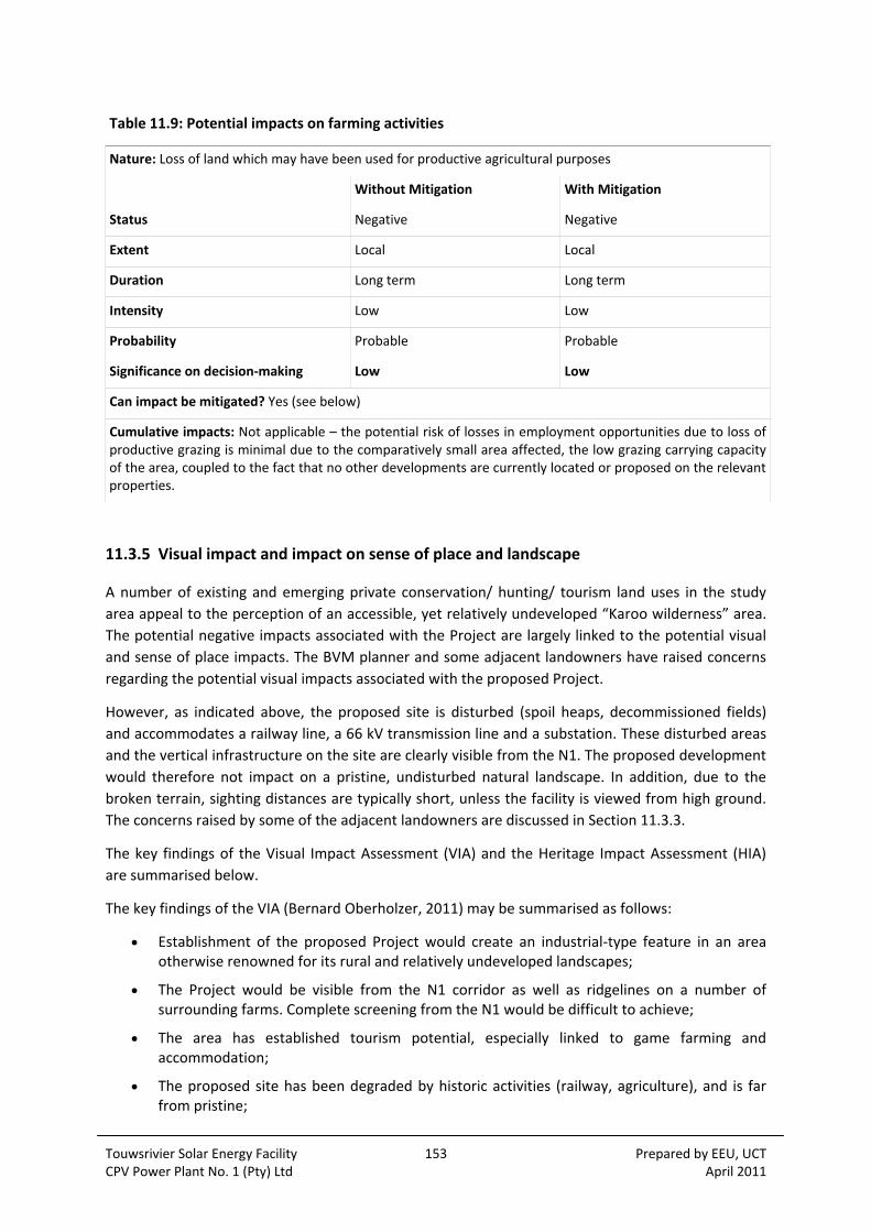
Touwsrivier Solar Energy Facility 153 Prepared by EEU, UCT CPV Power Plant No. 1 (Pty) Ltd April 2011
Table 11.9: Potential impacts on farming activities
Nature: Loss of land which may have been used for productive agricultural purposes
Without Mitigation With Mitigation
Status Negative Negative
Extent Local Local
Duration Long term Long term
Intensity Low Low
Probability Probable Probable
Significance on decision‐making Low Low
Can impact be mitigated? Yes (see below)
Cumulative impacts: Not applicable – the potential risk of losses in employment opportunities due to loss of productive grazing is minimal due to the comparatively small area affected, the low grazing carrying capacity of the area, coupled to the fact that no other developments are currently located or proposed on the relevant properties.
11.3.5 Visual impact and impact on sense of place and landscape
A number of existing and emerging private conservation/ hunting/ tourism land uses in the study
area appeal to the perception of an accessible, yet relatively undeveloped “Karoo wilderness” area.
The potential negative impacts associated with the Project are largely linked to the potential visual
and sense of place impacts. The BVM planner and some adjacent landowners have raised concerns
regarding the potential visual impacts associated with the proposed Project.
However, as indicated above, the proposed site is disturbed (spoil heaps, decommissioned fields)
and accommodates a railway line, a 66 kV transmission line and a substation. These disturbed areas
and the vertical infrastructure on the site are clearly visible from the N1. The proposed development
would therefore not impact on a pristine, undisturbed natural landscape. In addition, due to the
broken terrain, sighting distances are typically short, unless the facility is viewed from high ground.
The concerns raised by some of the adjacent landowners are discussed in Section 11.3.3.
The key findings of the Visual Impact Assessment (VIA) and the Heritage Impact Assessment (HIA)
are summarised below.
The key findings of the VIA (Bernard Oberholzer, 2011) may be summarised as follows:
Establishment of the proposed Project would create an industrial‐type feature in an area otherwise renowned for its rural and relatively undeveloped landscapes;
The Project would be visible from the N1 corridor as well as ridgelines on a number of surrounding farms. Complete screening from the N1 would be difficult to achieve;
The area has established tourism potential, especially linked to game farming and accommodation;
The proposed site has been degraded by historic activities (railway, agriculture), and is far from pristine;

Touwsrivier Solar Energy Facility 154 Prepared by EEU, UCT CPV Power Plant No. 1 (Pty) Ltd April 2011
The site’s location on a gently sloping plain would effectively mean that the Project would not affect scenic resources of the surrounding mountains and koppies.
The key conclusions of the VIA are the following:
Provided the implementation of mitigation measures, as outlined in the VIA (e.g. enforcement of development exclusion zones and the visual setback from the N1) , the visual impact of the proposed Project would be of medium significance; and
Potential cumulative visual impacts are not considered to be significant, as there are no other proposed renewable energy facilities within the same viewshed as the proposed Touwsrivier Project.
The key findings and conclusions of the specialist HIA (Hart, 20110) indicate that potential impacts of
the Project would be limited and localized, by in effect adding a further (ultra‐modern) layer to the
existing old industrial and rural agricultural layers. The HIA further notes that the proposed
development would not impact established tourism uses, and would be well‐screened from the N1.
The overall potential negative impacts of the proposed Project are considered acceptable with
mitigation (minimal disturbance of existing old industrial structures, screening, etc).
Table 11.10: Visual impact and impact on sense of place and the landscape
Nature: Visual impact associated with the proposed solar energy facility and the potential impact on the area’s rural sense of place and character of the landscape.
Without Mitigation With Mitigation
Status Negative Negative
Extent Local Local
Duration Long term Long term
Intensity Low Low
Probability Probable Probable
Significance on decision‐making Low – Medium Low – Medium
Can impact be mitigated? Yes (see below)
Cumulative impacts: No other similar developments currently exist or are being proposed in the study area.
Assessment of No‐Go option
There is no impact as it maintains the current status quo.
Recommended mitigation measures
The recommendations contained in the VIA and HIA should be implemented.
11.4 POTENTIAL HEALTH IMPACTS
The primary environmental, health, and safety issues associated with solar energy involve how they
are manufactured, installed, and ultimately disposed of. In particular, the manufacturing of
photovoltaic cells often requires hazardous materials such as arsenic and cadmium. Even relatively
inert silicon, a major material used in solar cells, can be hazardous to workers if it is breathed in as

Touwsrivier Solar Energy Facility 155 Prepared by EEU, UCT CPV Power Plant No. 1 (Pty) Ltd April 2011
dust. Workers involved in manufacturing photovoltaic modules and components must consequently
be protected from exposure to these materials. However, none of these potential hazards is much
different in quality or magnitude from the innumerable hazards people face routinely in an industrial
society. Through effective regulation, the dangers can very likely be kept at a very low level. In
addition, the relevant risks essentially concern workers at the cell manufacturing plant (in this case
Germany), and therefore this issue falls outside the scope of the EIA.
11.5 GRID CONNECTION ALTERNATIVES
As discussed in Section 4.8, three grid connection alternatives have been assessed in the EIA. Two of
these Alternatives (Option 1a and 1b) would require additional transmission lines to be constructed,
and Option 2 would entail the on‐site, direct linkup with an existing 66 kV transmission line which
traverses the site. Whereas Options 1a and 1b would allow for the full generation capacity of 50 MW
at grid connection point, Option 2 would only allow for a nominal generation capacity of
approximately 30 MW. This would mean a restriction in the size of the project which would put the
economic feasibility of the entire project at risk. More so, as the proposed scale of the Project is not
problematic from an SIA perspective (manageable potential negative impacts on local community
versus opportunities associated with employment creation, and so forth), the full realization of the
proposed facility’s capacity is desirable. As Option 2 would effectively result in 40% capacity
potential of the facility not being realised, this Option is not desirable from an SIA perspective.
Of the two remaining alternatives, Option 1a (preferred EIA alternative) is also the preferred SIA
alternative. This assessment is based on the shorter distance (±5 km versus ±7 km), and the fact that
the proposed Option 1a alignment would be located on the same property as the remainder of the
Project infrastructure, whereas Option 1b would require two additional properties (and owners) to
be affected. As neither alternative would have any significant impacts on existing and potential land
uses, and both moreover largely follow existing infrastructure (namely an existing fence line for
Option 1a, and a 66 kV Eskom line and railway line for Option 1b corridors), both alternatives are
acceptable from an SIA perspective
11.6 ASSESSMENT OF CUMULATIVE IMPACTS
Although there appear to be no guidelines for solar facilities, the Australian Wind Farm Development
Guidelines (Draft, July 2010) indicate that the cumulative impact of multiple wind farm facilities is
likely to become an increasingly important issue for wind farm developments in Australia. This
finding is also likely to apply to Solar Energy Facilities, and is also likely to be the case in South Africa.
The key concerns in terms of cumulative impacts are, as in the case of wind farms, also likely to be
linked to visual impacts and the impact on rural, undeveloped landscapes.
The Scottish Natural Heritage (2005) describes a range of potential cumulative landscape impacts
associated with wind farms on landscapes. These issues raised in these guidelines as to what defines
a cumulative impact are also regarded as pertinent to solar facilities, specifically given that the key
issue of concern is likely to relate to the impact on rural, undeveloped landscapes. The relevant
issues raised in the by Scottish Natural Heritage include:
Touwsrivier Solar Energy Facility 156 Prepared by EEU, UCT CPV Power Plant No. 1 (Pty) Ltd April 2011
Combined visibility (whether two or more wind farms (solar facilities) would be visible from one location);
Sequential visibility (e.g. the effect of seeing two or more wind farms (solar facilities) along a single journey, e.g. road or walking trail);
The visual compatibility of different wind farms (solar facilities) in the same vicinity;
Perceived or actual change in land use across a character type or region; and
Loss of a characteristic element (e.g. viewing type or feature) across a character type caused by developments across that character type.
The guidelines also note that cumulative impacts need to be considered in relation to dynamic as
well as static viewpoints. The experience of driving along a tourist road, for example, needs to be
considered as a dynamic sequence of views and visual impacts, not just as the cumulative impact of
several developments on one location. The viewer may only see one wind farm (solar facility) at a
time, but if each successive stretch of the road is dominated by views of a wind farm (solar facility),
then that can be argued to be a cumulative visual impact (National Wind Farm Development
Guidelines, DRAFT ‐ July 2010). It is reasonable to assume that these issues would also apply to solar
thermal plants.
Research on wind farms undertaken by Warren and Birnie (2009) also highlights the visual and
cumulative impacts on landscape character. The paper notes that given that aesthetic perceptions
are a key determinant of people’s attitudes, and that these perceptions are subjective, deeply felt
and diametrically contrasting, it is not hard to understand why the arguments become so heated.
Because landscapes are often an important part of people’s sense of place, identity and heritage,
perceived threats to familiar vistas have been fiercely resisted for centuries. The paper also identifies
two factors that are important in shaping people’s perceptions of wind farms’ landscape impacts.
The first of these is the cumulative impact of increasing numbers of wind farms (Campbell, 2008).
The research found that if people regard a region as having ‘enough’ wind farms already, then they
may oppose new proposals. The second factor is the cultural context. This relates to people’s
perception and relationship with the landscape. In the South African context, the majority of South
Africans have a strong connection with an affinity for the large, undisturbed open spaces that are
characteristic of the South African landscape. The concerns raised with regard to wind farms and the
impact on landscapes are also likely to apply to solar facilities.
The impact of solar facilities on the landscape is therefore likely to be a key issue in South Africa,
specifically given South African’s strong attachment to the land and the growing number of solar
plant applications.
The cumulative impacts associated with large, renewable energy facilities, such as the proposed
Touwsrivier Solar Energy Facility, are largely linked to the impact on sense of place and visual
impacts. In that regard, two further renewable energy facility developments are currently proposed
in the Touwsrivier area, namely the Konstabel facility (±22 km east of the Touwsrivier Solar Energy
Facility, proposed on both sides of the N1), and the Perdekraal facility (somewhat east of the
Touwsrivier Solar Energy Facility, ±25 km north of the N1). The relatively large distances involved,
and the fact that the Touwsrivier Solar Energy Facility would have a relatively low visibility profile (±7
m tallest structures), would serve in mitigation of cumulative impacts occurring. The location of both
the Touwsrivier and Perdekraal facilities in proximity to the N1 national road is in principle not ideal,
but the visual absorption provided by the broken landscape in the region would provide sufficient
mitigation. From an SIA point of view, the potential for cumulative impacts is not rated significant.

Touwsrivier Solar Energy Facility 157 Prepared by EEU, UCT CPV Power Plant No. 1 (Pty) Ltd April 2011
Table 11.11: Cumulative impacts on sense of place and the landscape
Nature: Visual impacts associated with the establishment of more than one solar thermal plant and the potential impact on the areas rural sense of place and character of the landscape.
Without Mitigation With Mitigation
Status Negative Positive
Extent Local‐District Local‐District
Duration Long term Long term
Intensity Low Low
Probability Probable Probable
Significance on decision‐making Low‐Medium Low
Can impact be mitigated? Yes (see below)
Cumulative impacts: Impact on other activities whose existence is linked to linked to rural sense of place and character of the area, such as tourism, conservation, hunting etc.
Assessment of No‐Go option
There is no impact as it maintains the current status quo.
Recommended mitigation measures
The establishment of more than one large solar facility in an area is likely to have a negative
cumulative impact on the areas sense of place and the landscape. The environmental authorities
should consider the overall cumulative impact on the rural character and the areas sense of place
before a final decision is taken with regard to the optimal number of such plants in an area.
11.7 ASSESSMENT OF NO‐DEVELOPMENT OPTION
As indicated above, South Africa currently relies on coal‐powered energy to meet more than 90% of
its energy needs. As a result South Africa is one of the highest per capita producers of carbon
emissions in the world and Eskom, as an energy utility, has been identified as the world’s second
largest producer carbon emissions. As discussed in Section 6.3, both the national and the Western
Cape provincial governments have set targets for renewable energy.
The No‐Development option would represent a lost opportunity for South Africa to supplement is
current energy needs with clean, renewable energy. Given South Africa’s position as one of the
highest per capita producer of carbon emissions in the world, this would represent a high negative
social cost. However, it should be noted that the proposed Project (as a renewable energy
development) is not unique. In this regard, a significant number of wind energy facility and solar
energy facility developments are currently proposed in the Western, Eastern and Northern Cape
Provinces. Foregoing the proposed development therefore does not necessarily spell the end of the
development of renewable energy facilities in the Western Cape or South Africa.

Touwsrivier Solar Energy Facility 158 Prepared by EEU, UCT CPV Power Plant No. 1 (Pty) Ltd April 2011
Table 11.12: Assessment of no‐development option
Nature: The no‐development option would result in the lost opportunity for South Africa to supplement its current energy needs with clean, renewable energy
Without Mitigation With Enhancement
Status Negative Positive
Extent Local‐National Local‐National
Duration Long term Long term
Intensity Low Low
Probability Highly Probable Highly Probable
Significance on decision‐making Medium Medium
Can impact be enhanced? Yes (see below)
Cumulative impacts: The cumulative impacts associated with the proposed Project include an increased awareness of the role of renewable energy and the impact of on climate change associated with the reliance of fossil fuels.
Recommended enhancement measures
The proposed facility should be developed and the mitigation and enhancement measures identified
in the SIA and other specialist studies should be implemented. However, the impact of large solar
facilities on the sense of place and landscape are issues that need to be addressed in the location,
design and layout of the proposed plant.
11.8 SOCIAL IMPACTS ASSOCIATED WITH DECOMISSIONING PHASE
Major social impacts associated with the decommissioning phase are typically linked to the loss of
jobs and associated income. This has implications for the households who are directly affected, the
communities within which they live, and the relevant local authorities.
However, in the case of the proposed Project, indications are that it is likely that the
decommissioning phase can be deferred by replacing the solar panels with more modern technology
at the end of their >25 year lifespan. In addition, the majority of the components that make up the
panels can be reused or recycled. The decommissioning phase is therefore likely to create additional
employment opportunities.
However, the potential impacts on the local community are likely to be significant when the
proposed facility is finally decommissioned. This is due to the relatively large number of permanent
local residents who stand to lose their jobs (100‐140). The potential impacts associated with the
decommissioning phase can be effectively managed with the implementation of a retrenchment and
downscaling programme. With mitigation, the impacts are assessed to have a low significance in
terms of decision making.
Touwsrivier Solar Energy Facility 159 Prepared by EEU, UCT CPV Power Plant No. 1 (Pty) Ltd April 2011
Recommended mitigation measures
The following mitigation measures are recommended:
CPV Power Plant No. 1 (Pty) Ltd should investigate the option of relocating employees to other solar energy facilities when the proposed Project is decommissioned;
CPV Power Plant No. 1 (Pty) Ltd should ensure that retrenchment packages are provided for all staff who stand to lose their jobs when the proposed Project is decommissioned; and
All structures and infrastructure associated with the proposed Project should be dismantled and transported off‐site on decommissioning.
CPV Power Plant No. 1 (Pty) Ltd should also make adequate and timeous provision for covering the
costs of eventual decommissioning and rehabilitation of disturbed areas. Establishing an
Environmental Rehabilitation Trust Fund may be an option to consider. Such a Trust Fund may be
funded by a percentage of the revenue generated from the sale of energy to the national grid over
the 25‐30 year operational life of the facility. An alternative funding model may be based on
earmarking the income from the eventual sale of recovered materials (e.g. steel, gold, stainless steel,
germanium, copper) from decommissioned CPV infrastructure.
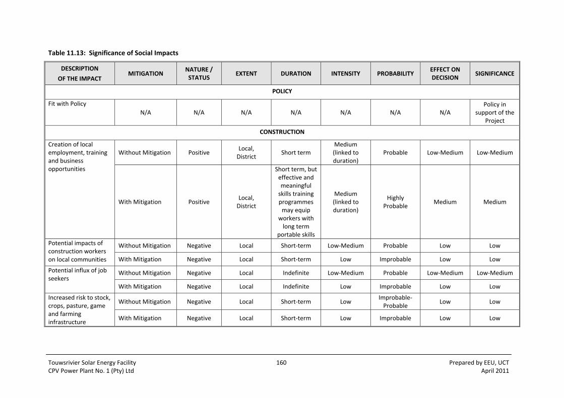
Touwsrivier Solar Energy Facility 160 Prepared by EEU, UCT CPV Power Plant No. 1 (Pty) Ltd April 2011
Table 11.13: Significance of Social Impacts
DESCRIPTION
OF THE IMPACT MITIGATION
NATURE / STATUS
EXTENT DURATION INTENSITY PROBABILITY EFFECT ON DECISION
SIGNIFICANCE
POLICY
Fit with Policy N/A N/A N/A N/A N/A N/A N/A
Policy in support of the
Project
CONSTRUCTION
Creation of local employment, training and business opportunities
Without Mitigation Positive Local, District
Short term Medium (linked to duration)
Probable Low‐Medium Low‐Medium
With Mitigation Positive Local, District
Short term, but effective and meaningful skills training programmes may equip
workers with long term
portable skills
Medium (linked to duration)
Highly Probable
Medium Medium
Potential impacts of construction workers on local communities
Without Mitigation Negative Local Short‐term Low‐Medium Probable Low Low
With Mitigation Negative Local Short‐term Low Improbable Low Low
Potential influx of job seekers
Without Mitigation Negative Local Indefinite Low‐Medium Probable Low‐Medium Low‐Medium
With Mitigation Negative Local Indefinite Low Improbable Low Low
Increased risk to stock, crops, pasture, game and farming infrastructure
Without Mitigation Negative Local Short‐term Low Improbable‐Probable
Low Low
With Mitigation Negative Local Short‐term Low Improbable Low Low

Touwsrivier Solar Energy Facility 161 Prepared by EEU, UCT CPV Power Plant No. 1 (Pty) Ltd April 2011
DESCRIPTION
OF THE IMPACT MITIGATION
NATURE / STATUS
EXTENT DURATION INTENSITY PROBABILITY EFFECT ON DECISION
SIGNIFICANCE
Potential impact on farmland due to construction related activities
Without Mitigation Negative Local
Long term‐permanent if
disturbed areas are not
rehabilitated
Low Probable Low Low
With Mitigation Negative Local
Very short term if
damaged areas are
rehabilitated
Low Improbable‐ Probable
Low Low
OPERATION
Potential employment and business creation opportunities
Without Mitigation Positive Local Long term Medium Probable Medium Medium
With Mitigation Positive Local Long term Medium‐High Highly
Probable Medium‐High Medium‐High
Development of clean, renewable energy infrastructure
Without Mitigation Positive Local, District, Provincial, National
Long term Low‐Medium Highly
Probable Medium Medium
With Mitigation Positive Local, District, Provincial, National
Long term Low‐Medium Highly
Probable Medium Medium
Potential Impacts on tourism
Without Mitigation Negative Local Long term Low‐Medium Probable Low‐Medium Low‐Medium
With Mitigation Negative Local Long term Low Probable Low Low
Potential impacts on farming activities
Without Mitigation Negative Local Long term Low Probable Low Low
With Mitigation Negative Local Long term Low Probable Low Low
Visual impact and impact on sense of place and the landscape
Without Mitigation Negative Local Long term Low Probable Low‐Medium Low‐Medium
With Mitigation Negative Local Long term Low Probable Low‐Medium Low‐Medium

Touwsrivier Solar Energy Facility 162 Prepared by EEU, UCT CPV Power Plant No. 1 (Pty) Ltd April 2011
DESCRIPTION
OF THE IMPACT MITIGATION
NATURE / STATUS
EXTENT DURATION INTENSITY PROBABILITY EFFECT ON DECISION
SIGNIFICANCE
Cumulative impacts on sense of place and the landscape
Without Mitigation Negative Local‐District Long term Low Probable Low‐Medium Low‐Medium
With Mitigation Positive Local‐District Long term Low Probable Low Low
DECOMMISSIONING
Impacts on the local community from loss of jobs and associated income
Without Mitigation Negative ‐ ‐ ‐ ‐ Low Low
With Mitigation Negative ‐ ‐ ‐ ‐ Significant Significant

Touwsrivier Solar Energy Facility 163 Prepared by EEU, UCT CPV Power Plant No. 1 (Pty) Ltd April 2011
12 VISUAL IMPACTS
The Visual Impact Assessment in Appendix 8.6 (Oberholzer and Lawson, 2011) sets out the potential
visual impact arising from the Project and corresponding mitigatory measures.
During the scoping stage and from site visits, the visual specialists identified a number of visual
issues. In addition, the public participation process (PPP) to date, as well as the social impact
assessment, have provided a number of visual issues detailed in Appendix 8.6 and summarised
below. These issues are not seen as impacts, but more as concerns that have been addressed in the
VIA.
Potential visual intrusion on sense of place;
Potential effect on landscape features and scenic resources;
Potential effect on local inhabitants, visitors to the area and on tourism;
Potential effect of the scale of the project;
Potential effect of glare and lights at night; and
Potential effect of construction and de‐commissioning.
Table 12.1 below sets out the assessment criteria and potential visual impacts / benefits arising from
the various components of the Project.
Table 12.3 summarises the significance of the visual impacts in accordance with the generic EIA
methodology for assessing significance described in Section 7.3.2.
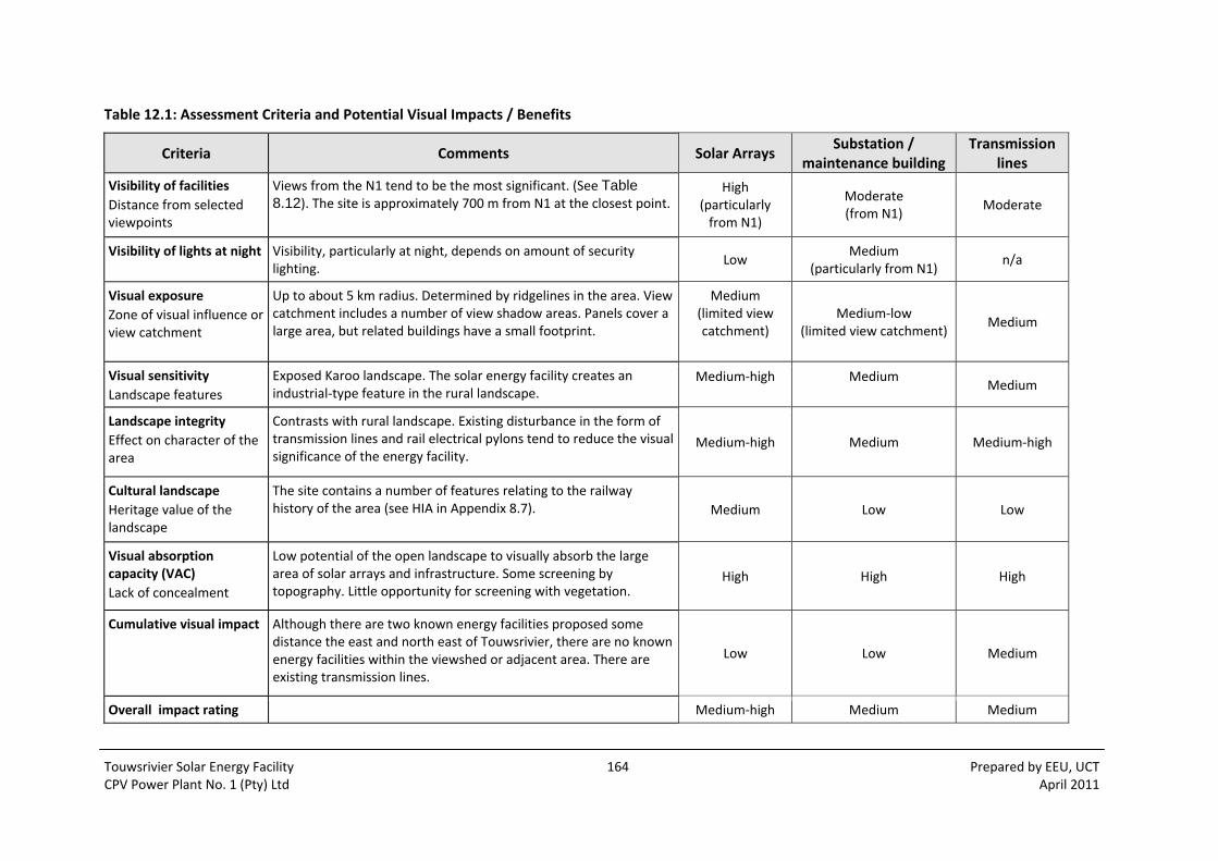
Touwsrivier Solar Energy Facility 164 Prepared by EEU, UCT CPV Power Plant No. 1 (Pty) Ltd April 2011
Table 12.1: Assessment Criteria and Potential Visual Impacts / Benefits
Criteria Comments Solar Arrays Substation /
maintenance building Transmission
lines
Visibility of facilities
Distance from selected viewpoints
Views from the N1 tend to be the most significant. (See Table 8.12). The site is approximately 700 m from N1 at the closest point.
High (particularly from N1)
Moderate (from N1)
Moderate
Visibility of lights at night Visibility, particularly at night, depends on amount of security lighting.
Low Medium
(particularly from N1) n/a
Visual exposure
Zone of visual influence or view catchment
Up to about 5 km radius. Determined by ridgelines in the area. View catchment includes a number of view shadow areas. Panels cover a large area, but related buildings have a small footprint.
Medium (limited view catchment)
Medium‐low (limited view catchment)
Medium
Visual sensitivity
Landscape features
Exposed Karoo landscape. The solar energy facility creates an industrial‐type feature in the rural landscape.
Medium‐high
Medium
Medium
Landscape integrity
Effect on character of the area
Contrasts with rural landscape. Existing disturbance in the form of transmission lines and rail electrical pylons tend to reduce the visual significance of the energy facility.
Medium‐high Medium Medium‐high
Cultural landscape
Heritage value of the landscape
The site contains a number of features relating to the railway history of the area (see HIA in Appendix 8.7). Medium Low Low
Visual absorption capacity (VAC)
Lack of concealment
Low potential of the open landscape to visually absorb the large area of solar arrays and infrastructure. Some screening by topography. Little opportunity for screening with vegetation.
High High High
Cumulative visual impact Although there are two known energy facilities proposed some distance the east and north east of Touwsrivier, there are no known energy facilities within the viewshed or adjacent area. There are existing transmission lines.
Low Low Medium
Overall impact rating Medium‐high Medium Medium
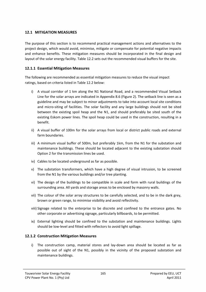
Touwsrivier Solar Energy Facility 165 Prepared by EEU, UCT CPV Power Plant No. 1 (Pty) Ltd April 2011
12.1 MITIGATION MEASURES
The purpose of this section is to recommend practical management actions and alternatives to the
project design, which would avoid, minimise, mitigate or compensate for potential negative impacts
and enhance benefits. These mitigation measures should be incorporated in the final design and
layout of the solar energy facility. Table 12.2 sets out the recommended visual buffers for the site.
12.1.1 Essential Mitigation Measures
The following are recommended as essential mitigation measures to reduce the visual impact
ratings, based on criteria listed in Table 12.2 below:
i) A visual corridor of 1 km along the N1 National Road, and a recommended Visual Setback
Line for the solar arrays are indicated in Appendix 8.6 (Figure 2). The setback line is seen as a
guideline and may be subject to minor adjustments to take into account local site conditions
and micro‐siting of facilities. The solar facility and any large buildings should not be sited
between the existing spoil heap and the N1, and should preferably be sited south of the
existing Eskom power lines. The spoil heap could be used in the construction, resulting in a
benefit.
ii) A visual buffer of 100m for the solar arrays from local or district public roads and external
farm boundaries.
iii) A minimum visual buffer of 500m, but preferably 1km, from the N1 for the substation and
maintenance buildings. These should be located adjacent to the existing substation should
Option 2 for the transmission lines be used.
iv) Cables to be located underground as far as possible.
v) The substation transformers, which have a high degree of visual intrusion, to be screened
from the N1 by the various buildings and/or tree planting.
vi) The design of the buildings to be compatible in scale and form with rural buildings of the
surrounding area. All yards and storage areas to be enclosed by masonry walls.
vii) The colour of the solar array structures to be carefully selected, and to be in the dark grey, brown or green range, to minimise visibility and avoid reflectivity.
viii) Signage related to the enterprise to be discrete and confined to the entrance gates. No other corporate or advertising signage, particularly billboards, to be permitted.
ix) External lighting should be confined to the substation and maintenance buildings. Lights
should be low‐level and fitted with reflectors to avoid light spillage.
12.1.2 Construction Mitigation Measures
i) The construction camp, material stores and lay‐down area should be located as far as
possible out of sight of the N1, possibly in the vicinity of the proposed substation and
maintenance buildings.

Touwsrivier Solar Energy Facility 166 Prepared by EEU, UCT CPV Power Plant No. 1 (Pty) Ltd April 2011
ii) The extent of the construction camp and stores should be limited in area to only that which
is essential.
iii) Disturbed areas rather than pristine or intact landscape areas should preferably be used for the construction camp.
iv) Measures to control wastes and litter should be included in the EMP and contract
specification documents.
v) Provision should be made for rehabilitation/ re‐vegetation of areas damaged by construction
activities.
vi) Borrow pits for the construction (which have not been identified), would be subject to permits from the relevant authorities.
12.1.3 Operational Mitigation Measures
i) The footprint of the operations and maintenance facilities, as well as parking and vehicular
circulation, should be clearly defined, and not be allowed to spill over into other areas of the
site.
ii) The operations and maintenance areas should be screened by buildings, walls, hedges
and/or tree planting, and should be kept in a tidy state to minimise further visual impact.
12.1.4 Recommendations for Monitoring
This visual impact assessment has identified the need for exclusion zones and other mitigations in
order to reduce potential visual impacts arising from the project. It is therefore recommended that
final layouts of the energy facilities, as well as designs for the various buildings be reviewed by the
EEU and the visual specialists, before construction commences.
Any future additional infrastructure, such as buildings, lighting, masts, or other elements, which
could visually intrude on the landscape, should first be reviewed by the EEU, or their sub‐
consultants, before being included in the EIA permit.

Touwsrivier Solar Energy Facility 167 Prepared by EEU, UCT CPV Power Plant No. 1 (Pty) Ltd April 2011
Table 12.2: Suggested Criteria for Visual Buffers at the Touwsrivier Site
Criteria PGWC Regional Level Mapping:
Recommended Buffers for Wind Farms (2006)
Local Project Level Mapping for Touwsrivier solar energy site: suggested buffers
Urban Areas 800 m n/a at Touwsrivier site
Residential Areas, including rural dwellings
400 m 100 m
Solar arrays are smaller than wind turbines and therefore require a smaller visual buffer.
National Roads
13 km buffer.
Depends on scenic value. Can be reduced.
1 km buffer
Area already degraded by rail lines, transmission lines and spoil heaps. Buffer based on alignment of existing rail lines and transmission lines. Solar arrays are smaller than wind turbines ‐ require a smaller visual buffer.
Local Public Roads
(district roads)
500 m
Review if high scenic value.
250 m
The nearest important road, the R46, is about 3 km away.
Provincial Tourist Route 4 km buffer. Statutory scenic drives. n/a at Touwsrivier site
Local Tourist Route
2.5 km
Assumption. Can be reduced.
n/a at Touwsrivier site
Railway lines 250 m 50 m
Solar arrays are smaller than wind turbines and are not a safety risk.
Local airfield To be confirmed with agency. n/a for the main site
National Parks, Provincial Nature Reserves
2 km
Should be eliminated at regional level.
2 km
The Bokkeriviere Nature Reserve is more than 7 km away.
Private Nature Reserves 500 m
Could be negotiated at local level.
500 m
The nearest proposed guest farms are more than 1 km away.
Rivers 500 m
For perennial rivers at regional level.
Hydrologist to determine site level buffers.
Site exclusion zones have been identified for the site.
External farm boundaries No indication 100 m visual buffer.
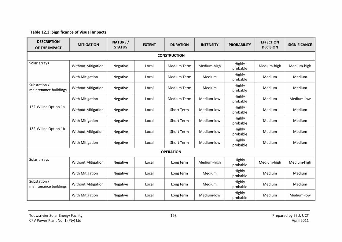
Touwsrivier Solar Energy Facility 168 Prepared by EEU, UCT CPV Power Plant No. 1 (Pty) Ltd April 2011
Table 12.3: Significance of Visual Impacts
DESCRIPTION
OF THE IMPACT MITIGATION
NATURE / STATUS
EXTENT DURATION INTENSITY PROBABILITY EFFECT ON DECISION
SIGNIFICANCE
CONSTRUCTION
Solar arrays Without Mitigation Negative Local Medium Term Medium‐high
Highly probable
Medium‐high Medium‐high
With Mitigation Negative Local Medium Term Medium Highly
probable Medium Medium
Substation / maintenance buildings Without Mitigation Negative Local Medium Term Medium
Highly probable
Medium Medium
With Mitigation Negative Local Medium Term Medium‐low Highly
probable Medium Medium‐low
132 kV line Option 1aWithout Mitigation Negative Local Short Term Medium‐low
Highly probable
Medium Medium
With Mitigation Negative Local Short Term Medium‐low Highly
probable Medium Medium
132 kV line Option 1bWithout Mitigation Negative Local Short Term Medium‐low
Highly probable
Medium Medium
With Mitigation Negative Local Short Term Medium‐low Highly
probable Medium Medium
OPERATION
Solar arrays Without Mitigation Negative Local Long term Medium‐high
Highly probable
Medium‐high Medium‐high
With Mitigation Negative Local Long term Medium Highly
probable Medium Medium
Substation / maintenance buildings Without Mitigation Negative Local Long term Medium
Highly probable
Medium Medium
With Mitigation Negative Local Long term Medium‐low Highly
probable Medium Medium‐low

Touwsrivier Solar Energy Facility 169 Prepared by EEU, UCT CPV Power Plant No. 1 (Pty) Ltd April 2011
DESCRIPTION
OF THE IMPACT MITIGATION
NATURE / STATUS
EXTENT DURATION INTENSITY PROBABILITY EFFECT ON DECISION
SIGNIFICANCE
Lights at nightWithout Mitigation Negative Local Long term Medium
Highly probable
Medium Medium
With Mitigation Negative Local Long term Medium‐low Highly
probable Medium‐low Medium‐low
132 kV line Option 1aWithout Mitigation Negative Local Long term Medium
Highly probable
Medium Medium
With Mitigation Negative Local Long term Medium Highly
probable Medium Medium
132 kV line Option 1bWithout Mitigation Negative Local Long term Medium
Highly probable
Medium Medium
With Mitigation Negative Local Long term Medium Highly
probable Medium Medium
DECOMMISSIONING
Solar arrays Without Mitigation Negative Local Permanent Medium‐low Probable Medium‐low Medium‐low
With Mitigation Negative Local Permanent Medium‐low Probable Medium‐low Medium‐low
Substation / maintenance buildings
Without Mitigation Negative Local Permanent Medium‐low Probable Medium‐low Medium‐low
With Mitigation Negative Local Permanent Medium‐low Probable Medium‐low Medium‐low
132 kV line Option 1a Without Mitigation Negative Local Permanent Medium‐low Probable Medium‐low Medium‐low
With Mitigation Negative Local Permanent Medium‐low Probable Medium‐low Medium‐low
132 kV line Option 1b Without Mitigation Negative Local Permanent Medium‐low Probable Medium‐low Medium‐low
With Mitigation Negative Local Permanent Medium‐low Probable Medium‐low Medium‐low

Touwsrivier Solar Energy Facility 170 Prepared by EEU, UCT CPV Power Plant No. 1 (Pty) Ltd April 2011

Touwsrivier Solar Energy Facility 171 Prepared by EEU, UCT CPV Power Plant No. 1 (Pty) Ltd April 2011
13 HERITAGE IMPACTS
The Heritage Impact Assessment (Hart, 2011) attached as Appendix 8.7 sets out the assessment of
potential impacts and mitigation relating to heritage.
Renewable energy facilities can produce a wide range of impacts that would affect the heritage
qualities of an area. The tracker sites would need to be prepared for receiving the apparatus –
vehicle access would need to be built and lay down and assembly areas established. As identified in
the Draft EMP (Ecosense, 2011), the presence of bedrock so close to the surface has significant
impact on the construction process. The installation of concrete gravity footings to the trackers
would likely require significant blasting requirements as well as generating significant rock that
would need to be crushed or spoiled and soil that would need to be spoiled. The use of piling and
rock anchors are an alternative possibility in some areas with less imported material (concrete) and
excavation and spoil requirements. Each tracker consists of a steel pole of 400 mm diameter wide
and maximum 7 m high. The solar panels which are to be mounted on the pole, are 5 x 6 meters
each. Since it is anticipated that there would be up to 8,300 trackers on the 215 ha site, they would
make a sizeable qualitative impact to the landscape.
13.1 KINDS OF IMPACTS THAT COULD TAKE PLACE
Sub‐surface interventions which have the potential to affect archaeology and palaeontology would
include the excavation of trenches for cabling, and the excavation or piling to construct the
foundations of the trackers, as well as the excavations of foundations for transmission line towers.
The cultural landscape (the unique interaction of human kind with the landscape as manifested in its
heritage and natural qualities, its evolution over time and its cultural and aesthetic qualities) can be
seriously impacted by new intrusive development layers which can change the identity of a locality
or even a region. During both the construction and operational phases the effect of a solar energy
facility on the quality of a cultural landscape is perhaps the most significant impact of all as it is this
impact that would persist for the duration of the life of the facility, and to an extent after the facility
has been decommissioned. Key issues that have been raised in the independent VIA is that
interested and affected parties are concerned about impacts to the wilderness qualities of the
general area in that tourism initiatives are based on wildlife tourism and game farming initiatives
rather than issues with respect to the human made heritage qualities of the site.
13.1.1 Residual impacts
Residual impacts can occur after the cessation of operations. The concrete bases may remain buried
in the ground indefinitely. Bankruptcy or neglect by the managing company can result in a situation
where the facility can remain an eyesore until such time it is demolished or re‐commissioned.
13.1.2 Cumulative impacts
Cumulative impacts within the site are not considered to be significant given that the area has
already been subject to years of disturbance. However concern is expressed with respect to the
large amount of industrial infrastructure which is proposed in the Karoo. At least 2 wind energy
facilities have been proposed for the Touwsrivier – Witberg area, while at least another 3 substantial

Touwsrivier Solar Energy Facility 172 Prepared by EEU, UCT CPV Power Plant No. 1 (Pty) Ltd April 2011
facilities are planned for the nearby Roggeveld Karoo. The Karoo, although used for stock farming, is
a wilderness landscape and an aesthetically valued wide open space that has a deeply South African
character. The large amount of industrial infrastructure that is proposed for this area is a direct
threat to its wilderness and aesthetic qualities and its regional tourism value. In particular small
Karoo towns such as Sutherland and Matjiesfontein are dependent on the sense of solitude and
historical charm that the Karoo context imparts. The potential cumulative impacts on these qualities
are both negative and significant.
13.1.3 Assessment of alternatives
Solar Facility
Implementation of the no‐go alternative would have no impacts on heritage. Subject to natural
environmental process, the heritage qualities of the place would remain the same. The impacts are
summarised in Table 13.1 below and have been assessed in accordance with the generic significance
criteria for EIA.
Grid Connections
The impacts of the grid connection alternatives impacts are summarised in Table 13.2, Table 13.3,
and Table 13.4 below.
Ideally Option 2 that involves a direct connection with the existing substation on site is the most
favoured alternative as the likelihood of negative impacts is extremely low.
Option 1a is the next favoured because it is of moderate length (5 km) and therefore would have a
comparatively low impact on the aesthetics of the area and any physical heritage resources which
have a low likelihood of occurring along the route.
Option 1b is the longest of the proposed routes. In heritage terms impacts are likely to be low as it
runs close to established infrastructure. However the costs of constructing a 7 km transmission line
makes this the least desirable overall alternative.
13.2 IMPACTS TO THE CULTURAL LANDSCAPE
While the study area at first glance has an agricultural rural appearance, much of the area is
effectively an old industrial landscape. During the 19th century it was the final exit point of the Hex
Pass railway line at Kleinstraat Junction, and was subject to further railway line construction in the
1930s. It was the site of the first attempt to tunnel through the Hex River Mountains – this was a
major engineering enterprise that saw a large amount of infrastructure built in the study area.
Finally in 1989 the new tunnel was completed which was a second major engineering operation on
the site. The demolition of the engineering infrastructure and the subsequent layer of agricultural
activities has given the landscape a rural look which although in keeping with the surrounding
landscape, was in actual fact a situation of relatively short duration (last 30 years) as historically the
land has seen a succession of engineering activities. Given the history of the site it is difficult to
argue that the addition of a further industrial layer in the form of the solar energy facility is out of
keeping with historical use of the place. The disused railway facilities have to some extent developed
a natural patina and the old lay‐down areas are now semi‐vegetated creating a degree of visual
harmony with the surrounding landscape. The general visual impacts are a concern as the addition
Touwsrivier Solar Energy Facility 173 Prepared by EEU, UCT CPV Power Plant No. 1 (Pty) Ltd April 2011
of a new industrial layer on the landscape would change the character of the area, and create a very
new large industrial presence. While this is compatible with the history of the site, it is at odds with
the surrounding landscape quality which is part rural, part wilderness.
13.2.1 Nature of impact
The impact to the cultural landscape relates to the fact that the old industrial landscape of the site,
which has developed a rural atmosphere in recent years would be subject to a layer of very new and
extensive 21st century technology which is at odds with rural qualities of the site, and the wilderness
qualities of the surrounds.
13.2.2 Extent of impact
The extent of the impact is local.
13.2.3 Mitigation
The old railway embankments would provide a considerable amount of screening of the proposed
activity from the N1. The mitigation measures proposed in the visual impact assessment are
supported.
13.3 IMPACTS TO PRE‐COLONIAL ARCHAEOLOGY
Existing farm tracks and roads would be upgraded and used, while stretches of additional road
would be needed to gain access to the tracker positions. While these activities have the potential to
impact pre‐colonial archaeology all this activity would take place in disturbed land which has either
been ploughed or previously disturbed by earlier industrial activity. Furthermore, there is very little
evidence of archaeological material on the site. Hence the significance of any impacts that may take
place would be very low to non‐existent.
13.3.1 Nature of impact
The disturbance of in‐situ archaeological material by excavation trenching and road building.
13.3.2 Extent of impacts
Not applicable
13.3.3 Mitigation
No mitigation measures are required with respect to pre‐colonial archaeological heritage as no
significant finds were identified within the study area.
Depending on the type and location of grid connection selected, a final walk down of the 132 kV
transmission line would be required so that tower positions can be micro‐adjusted to avoid any
sensitive areas.
Touwsrivier Solar Energy Facility 174 Prepared by EEU, UCT CPV Power Plant No. 1 (Pty) Ltd April 2011
13.4 IMPACTS TO HISTORICAL INDUSTRIAL ARCHAEOLOGY
The proposed activity would not directly affect any of the historical elements on the site as the
trackers would be constructed between and around the various elements which would largely
remain as is. The proponent has expressed an interest in utilizing the gravel ballast (for crush and
concrete batching, road layer works, lay‐down areas etc.) which still lies along the 1930 railway
alignment. This activity which is seen as an environmentally sound re‐utilization of resources would
not erase the footprint of the railway as there are long lengths of embankment and cuttings which
signify its presence. The impact of this activity is considered to be of low significance provided that a
policy of minimal intervention is followed with the remaining historic railway infrastructure.
13.4.1 Nature of impact
The activity would involve minimal impact to the surviving fabric of the historic railway system.
13.4.2 Extent of impact
The impact is local in extent.
13.4.3 Mitigation
Mitigation measures are proposed with respect to the conservation of the various elements of
railway infrastructure.
The old 1876 rail alignment is both protected as an archaeological site and as an element of the built environment. The 1930 railway line alignments, power station foundations, 1946 tunnel portal are protected as elements of the built environment over 60 years of age. It is recommended that a policy of minimal intervention is implemented whereby the structures are left as is.
Any necessary changes, destruction or physical alteration of these elements would necessitate applying for a permit to modify a protected structure from Heritage Western Cape.
It is recommended that in the broader interests of resource conservation and sustainability, re‐use of ballast gravel from the 1930 railway alignment be permitted provided that the railway alignment remains a legible feature of the landscape. This means not destroying the embankments, culverts, cuttings or other railway related features.
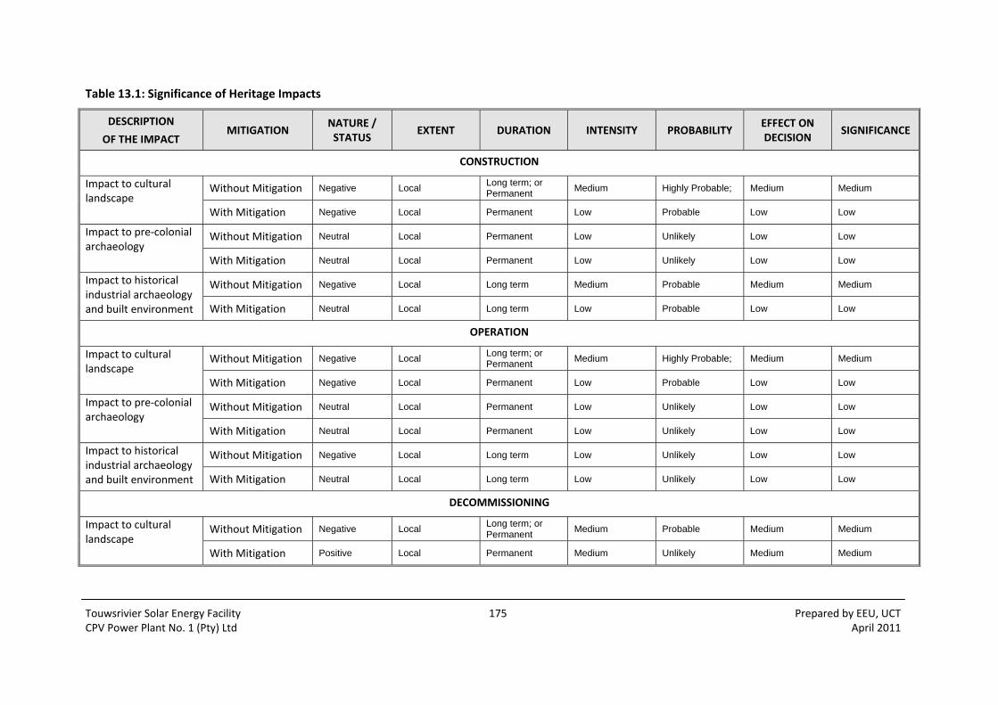
Touwsrivier Solar Energy Facility 175 Prepared by EEU, UCT CPV Power Plant No. 1 (Pty) Ltd April 2011
Table 13.1: Significance of Heritage Impacts
DESCRIPTION
OF THE IMPACT MITIGATION
NATURE / STATUS
EXTENT DURATION INTENSITY PROBABILITY EFFECT ON DECISION
SIGNIFICANCE
CONSTRUCTION
Impact to cultural landscape
Without Mitigation Negative Local Long term; or Permanent
Medium Highly Probable; Medium Medium
With Mitigation Negative Local Permanent Low Probable Low Low
Impact to pre‐colonial archaeology
Without Mitigation Neutral Local Permanent Low Unlikely Low Low
With Mitigation Neutral Local Permanent Low Unlikely Low Low
Impact to historical industrial archaeology and built environment
Without Mitigation Negative Local Long term Medium Probable Medium Medium
With Mitigation Neutral Local Long term Low Probable Low Low
OPERATION
Impact to cultural landscape
Without Mitigation Negative Local Long term; or Permanent
Medium Highly Probable; Medium Medium
With Mitigation Negative Local Permanent Low Probable Low Low
Impact to pre‐colonial archaeology
Without Mitigation Neutral Local Permanent Low Unlikely Low Low
With Mitigation Neutral Local Permanent Low Unlikely Low Low
Impact to historical industrial archaeology and built environment
Without Mitigation Negative Local Long term Low Unlikely Low Low
With Mitigation Neutral Local Long term Low Unlikely Low Low
DECOMMISSIONING
Impact to cultural landscape
Without Mitigation Negative Local Long term; or Permanent
Medium Probable Medium Medium
With Mitigation Positive Local Permanent Medium Unlikely Medium Medium

Touwsrivier Solar Energy Facility 176 Prepared by EEU, UCT CPV Power Plant No. 1 (Pty) Ltd April 2011
DESCRIPTION
OF THE IMPACT MITIGATION
NATURE / STATUS
EXTENT DURATION INTENSITY PROBABILITY EFFECT ON DECISION
SIGNIFICANCE
Impact to pre‐colonial archaeology
Without Mitigation Neutral Local Permanent Low Unlikely Low Low
With Mitigation Neutral Local Permanent Low Unlikely Low Low
Impact to historical industrial archaeology and built environment
Without Mitigation Neutral Local Long term Low Unlikely Low Low
With Mitigation Neutral Local Long term Low Unlikely Low Low
Table 13.2: Significance of Heritage Impacts – Option 1a
DESCRIPTION
OF THE IMPACT MITIGATION
NATURE / STATUS
EXTENT DURATION INTENSITY PROBABILITY EFFECT ON DECISION
SIGNIFICANCE
OPTION 1a
Impact to cultural landscape
Without Mitigation Neutral Local Permanent Low Unlikely Low Low
With Mitigation Neutral Local Permanent Low Unlikely Low Low
Impact to pre‐colonial archaeology
Without Mitigation Neutral Local Permanent Low Unlikely Low Low
With Mitigation Neutral Local Permanent Low Unlikely Low Low
Impact to historical industrial archaeology and built environment
Without Mitigation Neutral Local Permanent Low Unlikely Low Low
With Mitigation Neutral Local Permanent Low Unlikely Low Low

Touwsrivier Solar Energy Facility 177 Prepared by EEU, UCT CPV Power Plant No. 1 (Pty) Ltd April 2011
Table 13.3: Significance of Heritage Impacts – Option 1b
DESCRIPTION
OF THE IMPACT MITIGATION
NATURE / STATUS
EXTENT DURATION INTENSITY PROBABILITY EFFECT ON DECISION
SIGNIFICANCE
OPTION 1b
Impact to cultural landscape
Without Mitigation Neutral Local Permanent Low Unlikely Low Low
With Mitigation Neutral Local Permanent Low Unlikely Low Low
Impact to pre‐colonial archaeology
Without Mitigation Neutral Local Permanent Low Unlikely Low Low
With Mitigation Neutral Local Permanent Low Unlikely Low Low
Impact to historical industrial archaeology and built environment
Without Mitigation Neutral Local Permanent Low Unlikely Low Low
With Mitigation Neutral Local Permanent Low Unlikely Low Low
Table 13.4: Significance of Heritage Impacts – Option 2
DESCRIPTION
OF THE IMPACT MITIGATION
NATURE / STATUS
EXTENT DURATION INTENSITY PROBABILITY EFFECT ON DECISION
SIGNIFICANCE
OPTION 2
Impact to cultural landscape
Without Mitigation Neutral Local Permanent Low Unlikely Low Low
With Mitigation Neutral Local Permanent Low Unlikely Low Low
Impact to pre‐colonial archaeology
Without Mitigation Neutral Local Permanent Low Unlikely Low Low
With Mitigation Neutral Local Permanent Low Unlikely Low Low
Impact to historical industrial archaeology and built environment
Without Mitigation Neutral Local Permanent Low Unlikely Low Low
With Mitigation Neutral Local Permanent Low Unlikely Low Low

Touwsrivier Solar Energy Facility 178 Prepared by EEU, UCT CPV Power Plant No. 1 (Pty) Ltd April 2011
Touwsrivier Solar Energy Facility 179 Prepared by EEU, UCT CPV Power Plant No. 1 (Pty) Ltd April 2011
14 PALAEONTOLOGICAL IMPACTS The Palaeontological Impact Assessment (Almond, 2011) attached as Appendix 8.8 sets out the
assessment of potential impacts and mitigation relating to palaeontology.
14.1.1 Nature and status of impact
In general significant impacts on buried or exposed palaeontological heritage take place during the
construction, rather than operational or decommissioning, phase of a major development. Impacts
are more likely to be significant when construction involves substantial excavations into fossiliferous
bedrock or superficial sediments.
During the construction phase of the proposed Touwsrivier Solar Energy Facility fossil remains
preserved within Palaeozoic bedrock or superficial sediments underlying the proposed development,
or lying on the surface within the development area, may be disturbed, damaged or destroyed by
excavations and other activities (e.g. vehicle use) that are associated with the emplacement of solar
trackers and associated infrastructure (e.g. underground electrical cables, new roads, construction of
a new substation, transmission pylon emplacement). Additional areas of potentially fossiliferous
bedrock may be sealed‐in or sterilized by infrastructure such as parking and standing areas, access
roads and storage areas.
All these developments may adversely affect legally protected fossil heritage within the
development area since the fossils are no longer available for scientific research or other public
good. In the absence of specialist palaeontological mitigation, the impact status of such
developments on local fossil heritage is therefore generally negative. However, where appropriate
mitigation is ensured – such as the recording and judicious sampling of fossil remains by a qualified
palaeontologist before and / or during the construction phase ‐ the overall impact status of a
development may well change to positive since in the longer term access to and understanding of
local fossil heritage may well be significantly enhanced.
14.1.2 Extent of impact
The impact of the proposed development on fossil heritage is likely to be local in extent, since fairly
rich fossil localities within the same geological units are already known elsewhere in the region.
14.1.3 Duration of impact
Loss of recorded or unrecorded fossil heritage during the construction phase of the proposed
development is permanent.
The operational and decommissioning phases of the wind energy facility would not involve further
significant adverse or other impacts on palaeontological heritage.
14.1.4 Intensity of impact
The intensity of the impact on fossil heritage represented by the proposed development is
considered to be low in view of the relatively sparse distribution of fossils within the study area as
inferred from the field assessment study. Furthermore, large‐volume excavations of potentially
fossiliferous bedrock are not envisaged for this development project.

Touwsrivier Solar Energy Facility 180 Prepared by EEU, UCT CPV Power Plant No. 1 (Pty) Ltd April 2011
14.1.5 Probability of impact
Since the Voorstehoek Formation that underlies the greater part of the proposed development
footprint is known to be generally fossiliferous, it is considered probable that construction of the
solar energy facility would have an impact on fossil heritage.
14.1.6 Effect on decision making
In view of the above, the overall impact significance of the proposed development on fossil heritage
is considered to be low. The inferred significance of impacts of the solar energy facility and the
alternative grid connections are summarised in Table 14.1 and Table 14.2 below.
Given the generally low palaeontological sensitivity of the Bokkeveld bedrocks and alluvial cover
sediments in the region and the small number of pylon emplacements concerned, none of these
options would substantially compromise local fossil heritage, and there is no preferred option on
palaeontological grounds.
The No‐Go option would not have a significant impact on local fossil heritage.
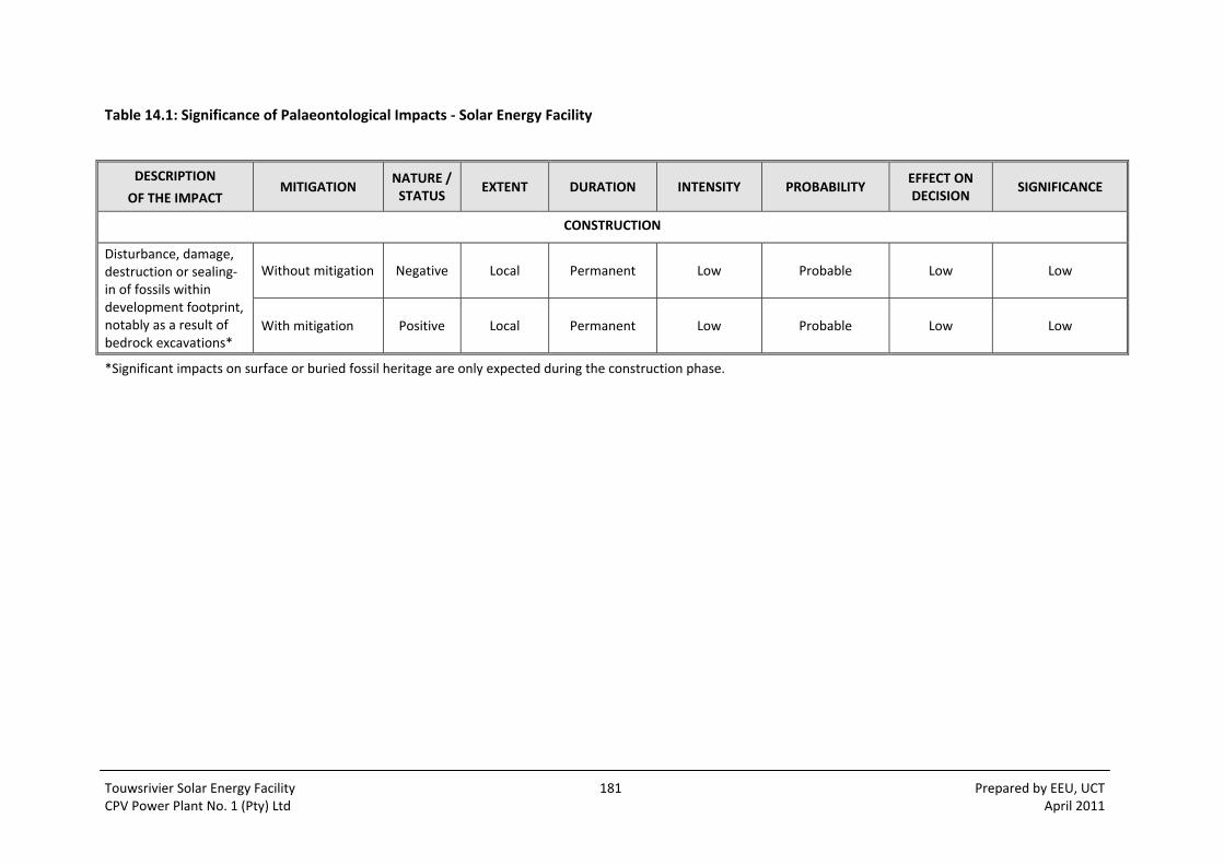
Touwsrivier Solar Energy Facility 181 Prepared by EEU, UCT CPV Power Plant No. 1 (Pty) Ltd April 2011
Table 14.1: Significance of Palaeontological Impacts ‐ Solar Energy Facility
DESCRIPTION
OF THE IMPACT MITIGATION
NATURE / STATUS
EXTENT DURATION INTENSITY PROBABILITY EFFECT ON DECISION
SIGNIFICANCE
CONSTRUCTION
Disturbance, damage, destruction or sealing‐in of fossils within development footprint, notably as a result of bedrock excavations*
Without mitigation Negative Local Permanent Low Probable Low Low
With mitigation Positive Local Permanent Low Probable Low Low
*Significant impacts on surface or buried fossil heritage are only expected during the construction phase.
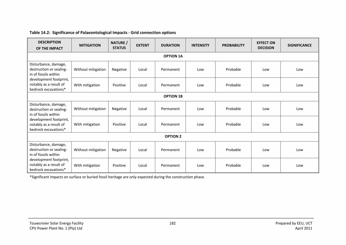
Touwsrivier Solar Energy Facility 182 Prepared by EEU, UCT CPV Power Plant No. 1 (Pty) Ltd April 2011
Table 14.2: Significance of Palaeontological Impacts ‐ Grid connection options
DESCRIPTION
OF THE IMPACT MITIGATION
NATURE / STATUS
EXTENT DURATION INTENSITY PROBABILITY EFFECT ON DECISION
SIGNIFICANCE
OPTION 1A
Disturbance, damage, destruction or sealing‐in of fossils within development footprint, notably as a result of bedrock excavations*
Without mitigation Negative Local Permanent Low Probable Low Low
With mitigation Positive Local Permanent Low Probable Low Low
OPTION 1B
Disturbance, damage, destruction or sealing‐in of fossils within development footprint, notably as a result of bedrock excavations*
Without mitigation Negative Local Permanent Low Probable Low Low
With mitigation Positive Local Permanent Low Probable Low Low
OPTION 2
Disturbance, damage, destruction or sealing‐in of fossils within development footprint, notably as a result of bedrock excavations*
Without mitigation Negative Local Permanent Low Probable Low Low
With mitigation Positive Local Permanent Low Probable Low Low
*Significant impacts on surface or buried fossil heritage are only expected during the construction phase.

Touwsrivier Solar Energy Facility 183 Prepared by EEU, UCT CPV Power Plant No. 1 (Pty) Ltd April 2011
15 CONCLUSIONS AND RECOMMENDATIONS
15.1 OVERVIEW
The Scoping and EIA process for the Touwsrivier Solar Energy Facility has been undertaken by the
Environmental Evaluation Unit (EEU) in terms of the National Environmental Management Act (107
of 1998) EIA Regulations (GN R385, GN R386 and GN R387 of April 2006). The process has involved
working closely with the relevant specialists, liaising with the commenting authorities, consulting
with the public, as well as iteratively feeding back to the applicant to inform the project design.
This Scoping and EIA process has assessed the project on the preferred site, arrived at through a
preliminary assessment and comparative evaluation of other locations in the vicinity. The ‘No Go’
option which involves maintaining the Status Quo has also been assessed. In addition, the EIA
process has comparatively assessed three different Grid Connection Alternatives (two of which
involve a proposed new 132 kV transmission line). The Scoping and EIA process has also considered,
although not comparatively assessed, Design and Layout, Technology, and Input Alternatives.
Through an iterative process the alternatives have been considered, environmental impacts have
been identified and assessed, and the specialists have recommended mitigation measures to
address these impacts. A summary table of the impacts identified for each project phase is provided
overleaf followed by the general conclusions from each specialist study.
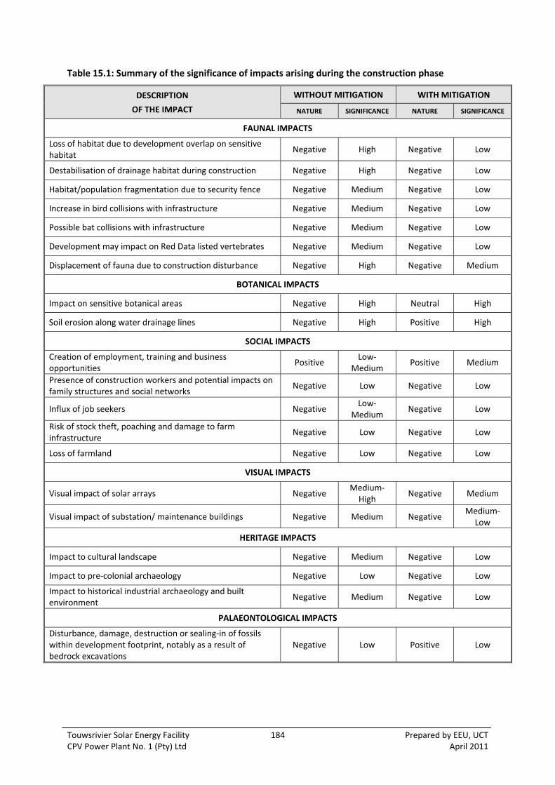
Touwsrivier Solar Energy Facility 184 Prepared by EEU, UCT CPV Power Plant No. 1 (Pty) Ltd April 2011
Table 15.1: Summary of the significance of impacts arising during the construction phase
DESCRIPTION
OF THE IMPACT
WITHOUT MITIGATION WITH MITIGATION
NATURE SIGNIFICANCE NATURE SIGNIFICANCE
FAUNAL IMPACTS
Loss of habitat due to development overlap on sensitive habitat
Negative High Negative Low
Destabilisation of drainage habitat during construction Negative High Negative Low
Habitat/population fragmentation due to security fence Negative Medium Negative Low
Increase in bird collisions with infrastructure Negative Medium Negative Low
Possible bat collisions with infrastructure Negative Medium Negative Low
Development may impact on Red Data listed vertebrates Negative Medium Negative Low
Displacement of fauna due to construction disturbance Negative High Negative Medium
BOTANICAL IMPACTS
Impact on sensitive botanical areas Negative High Neutral High
Soil erosion along water drainage lines Negative High Positive High
SOCIAL IMPACTS
Creation of employment, training and business opportunities
Positive Low‐
Medium Positive Medium
Presence of construction workers and potential impacts on family structures and social networks
Negative Low Negative Low
Influx of job seekers Negative Low‐
Medium Negative Low
Risk of stock theft, poaching and damage to farm infrastructure
Negative Low Negative Low
Loss of farmland Negative Low Negative Low
VISUAL IMPACTS
Visual impact of solar arrays Negative Medium‐High
Negative Medium
Visual impact of substation/ maintenance buildings Negative Medium Negative Medium‐
Low
HERITAGE IMPACTS
Impact to cultural landscape Negative Medium Negative Low
Impact to pre‐colonial archaeology Negative Low Negative Low
Impact to historical industrial archaeology and built environment
Negative Medium Negative Low
PALAEONTOLOGICAL IMPACTS
Disturbance, damage, destruction or sealing‐in of fossils within development footprint, notably as a result of bedrock excavations
Negative Low Positive Low
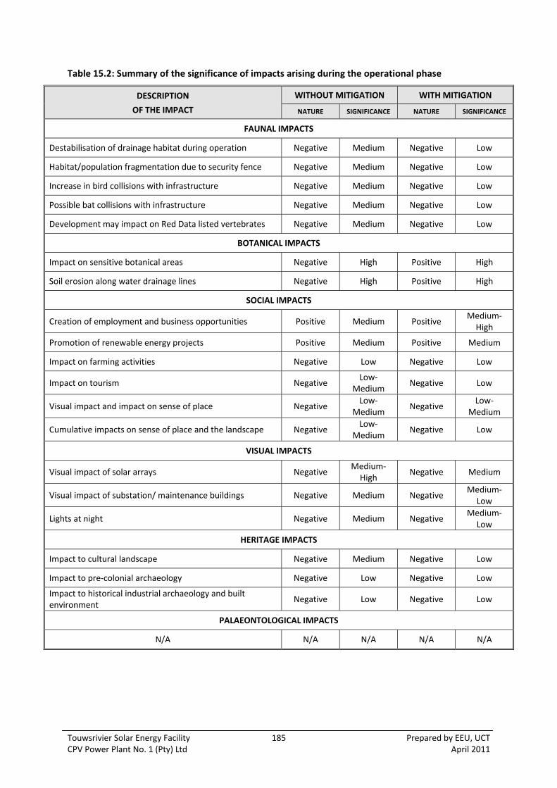
Touwsrivier Solar Energy Facility 185 Prepared by EEU, UCT CPV Power Plant No. 1 (Pty) Ltd April 2011
Table 15.2: Summary of the significance of impacts arising during the operational phase
DESCRIPTION
OF THE IMPACT
WITHOUT MITIGATION WITH MITIGATION
NATURE SIGNIFICANCE NATURE SIGNIFICANCE
FAUNAL IMPACTS
Destabilisation of drainage habitat during operation Negative Medium Negative Low
Habitat/population fragmentation due to security fence Negative Medium Negative Low
Increase in bird collisions with infrastructure Negative Medium Negative Low
Possible bat collisions with infrastructure Negative Medium Negative Low
Development may impact on Red Data listed vertebrates Negative Medium Negative Low
BOTANICAL IMPACTS
Impact on sensitive botanical areas Negative High Positive High
Soil erosion along water drainage lines Negative High Positive High
SOCIAL IMPACTS
Creation of employment and business opportunities Positive Medium Positive Medium‐High
Promotion of renewable energy projects Positive Medium Positive Medium
Impact on farming activities Negative Low Negative Low
Impact on tourism Negative Low‐
Medium Negative Low
Visual impact and impact on sense of place Negative Low‐
Medium Negative
Low‐Medium
Cumulative impacts on sense of place and the landscape Negative Low‐
Medium Negative Low
VISUAL IMPACTS
Visual impact of solar arrays Negative Medium‐High
Negative Medium
Visual impact of substation/ maintenance buildings Negative Medium Negative Medium‐
Low
Lights at night Negative Medium Negative Medium‐
Low
HERITAGE IMPACTS
Impact to cultural landscape Negative Medium Negative Low
Impact to pre‐colonial archaeology Negative Low Negative Low
Impact to historical industrial archaeology and built environment
Negative Low Negative Low
PALAEONTOLOGICAL IMPACTS
N/A N/A N/A N/A N/A

Touwsrivier Solar Energy Facility 186 Prepared by EEU, UCT CPV Power Plant No. 1 (Pty) Ltd April 2011
Table 15.3: Summary of the significance of impacts arising during the decommissioning phase
DESCRIPTION
OF THE IMPACT
WITHOUT MITIGATION WITH MITIGATION
NATURE SIGNIFICANCE NATURE SIGNIFICANCE
FAUNAL IMPACTS
Destabilisation of drainage habitat during decommissioning Negative Medium Negative Low
Development may impact on Red Data listed vertebrates Negative Medium Negative Low
Displacement of fauna due to construction disturbance Negative High Negative Medium
BOTANICAL IMPACTS
N/A N/A N/A N/A N/A
SOCIAL IMPACTS
Loss of jobs and associated income Negative Significant Negative Significant
VISUAL IMPACTS
Visual impact of solar arrays Negative Medium‐
Low Negative
Medium‐Low
Visual impact of substation/ maintenance buildings Negative Medium‐
Low Negative
Medium‐Low
HERITAGE IMPACTS
Impact to cultural landscape Positive Medium Positive Medium
Impact to pre‐colonial archaeology Neutral Low Neutral Low
Impact to historical industrial archaeology and built environment
Neutral Low Neutral Low
PALAEONTOLOGICAL IMPACTS
N/A N/A N/A N/A N/A

Touwsrivier Solar Energy Facility 187 Prepared by EEU, UCT CPV Power Plant No. 1 (Pty) Ltd April 2011
Table 15.4: Comparison of the significance of impacts for each grid connection alternative
Option 1a Option 1b Option 2
DESCRIPTION
OF THE IMPACT NATURE
WITHOUT MITIGATION
WITH MITIGATION
NATURE WITHOUT
MITIGATION WITH
MITIGATION NATURE
WITHOUT MITIGATION
WITH MITIGATION
FAUNAL IMPACTS
Impacts on fauna and fauna habitat Negative Low Low Negative Low Low Neutral Neutral Neutral
BOTANICAL IMPACTS
Disturbance of sensitive vegetation Negative
→ Neutral
High Medium Negative High High Neutral Low Low
Acceleration of soil erosion along drainage lines Negative
→ Positive
High Medium Negative High High Neutral Low Low
SOCIAL IMPACTS
Risk to project feasibility Neutral Neutral Neutral Neutral Neutral Neutral Negative Significant Significant
Effect on adjacent landowners Neutral Neutral Neutral Negative Significant Significant Neutral Neutral Neutral
VISUAL IMPACTS
Visual impact of Option during construction Negative Medium Medium Negative Medium Medium Neutral Neutral Neutral
Visual impact of Option during operation Negative Medium Medium Negative Medium Medium Neutral Neutral Neutral
Visual impact of Option during decommissioning Negative Medium‐Low Medium‐Low Negative Medium‐Low Medium‐Low Neutral Neutral Neutral
HERITAGE IMPACTS
Impact to cultural landscape Neutral Low Low Neutral Low Low Neutral Low Low
Impact to pre‐colonial archaeology Neutral Low Low Neutral Low Low Neutral Low Low
Impact to historical industrial archaeology and built environment
Neutral Low Low Neutral Low Low Neutral Low Low
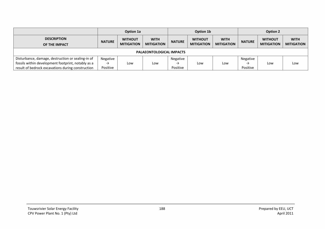
Touwsrivier Solar Energy Facility 188 Prepared by EEU, UCT CPV Power Plant No. 1 (Pty) Ltd April 2011
Option 1a Option 1b Option 2
DESCRIPTION
OF THE IMPACT NATURE
WITHOUT MITIGATION
WITH MITIGATION
NATURE WITHOUT
MITIGATION WITH
MITIGATION NATURE
WITHOUT MITIGATION
WITH MITIGATION
PALAEONTOLOGICAL IMPACTS
Disturbance, damage, destruction or sealing‐in of fossils within development footprint, notably as a result of bedrock excavations during construction
Negative →
Positive Low Low
Negative →
Positive Low Low
Negative →
Positive Low Low
Touwsrivier Solar Energy Facility 189 Prepared by EEU, UCT CPV Power Plant No. 1 (Pty) Ltd April 2011
15.2 AGRICULTURE
According to the agricultural specialist study, the former cultivated lands of the study area are no
longer economically productive and that their productive potential was probably originally
overestimated.
Both the extremes of the climate and the nature of the substrate make the further agricultural
cultivation of the area unwise and difficult to justify financially. Even rehabilitation under the expert
guidance of the Department of Agriculture has not been successful.
Water extraction for cultivation would have a negative impact on the general area, and would only
result in the further aridification of the land.
It is therefore recommended that the former cultivated lands of the study area should not be used
for agricultural production and that the disturbed areas be made available for some other type of
land use.
15.3 GEOLOGY AND HYDROLOGY
The Geotechnical Report (Appendix 8.1) sets out a number of development considerations based on
the existing geology within the study area. These would assist with the design of the facility and the
layout in particular. Although it has not formed part of the impact assessment, opportunities have
been identified to improve the overall quality of the environment within the study area.
15.3.1 Drainage Channels
The geotechnical investigation found that rather than being in a natural condition, most of the
drainage channels on the site comprise excavated trenches or artificially re‐located stream lines with
the entrance and exit points dictated by culvert positions. Railways and road side‐drains along cuts
and fills divert nearly all sheetwash into these drains.
The relatively straight channels at fairly constant gradients with smooth beds offer little in the way
of flood attenuation. This function is performed mainly by the small and large dams present on site.
The modification of the drainage channels to reduce erosion, has thus been recommended by the
geotechnical specialist.
The widths of the channels should be matched to the current widths of the existing channels. A
buffer of no development of approximately 15 m to cater for possible erosion in a flood, should be
maintained on both sides of the channel. Suitable gabion rock and backfill material is available on
site.
15.3.2 Boreholes
Detailed groundwater quality tests have not been conducted, however a single test on a sample
from the southernmost borehole reportedly indicated a “salt concentration of 700 ppm.” It has
proved to be drinkable on site and it is therefore expected to be suitable for concrete mixing but
might require filtration for purposes of washing solar panels and drinking.
Touwsrivier Solar Energy Facility 190 Prepared by EEU, UCT CPV Power Plant No. 1 (Pty) Ltd April 2011
15.3.3 Construction materials
A number of material types and sources are available on or near the site were identified during the
geotechnical investigation. An example includes suitable gabion rock and backfill material which
could assist with the stabilisation of the drainage channel. The use of these resources should be
investigated by the contractor as there exists the opportunity to improve the feasibility of the
project and reduce the amount of material and traffic movements to the site, with a reduction in
impacts.
15.3.4 Development Considerations
The Geotechnical Report (Appendix 8.1) provides more detailed conclusions and recommendations
relating to founding conditions, excavation, construction materials and development considerations.
In summary, based on the geotechnical information gathered, the site is considered to be suitable
for the proposed development. Good founding is generally available and ranges from rock at surface
to dense silty sands underlain by gravels and bedrock at shallow depths. Excavation conditions for
trenches and shallow foundations vary significantly from hard rock to soft soil but on the whole are
also good.
Certain areas of the site can be developed more easily and at less cost than others which should be
taken into account in planning the expansion programme. Judicious orientation of trenches and
tracks in keeping with the geological structure as well as the development of appropriate founding
methods for different parts of the site could lead to significant time and cost savings.
15.4 BOTANY
The proposed development does not pose a threat to the environment, both in terms of botanical
biodiversity pattern (rare or threatened plant species) or important ecological processes.
If mitigation measures are followed the proposed development holds no potential negative
cumulative impacts on the local environment or Critical Biodiversity Areas in the region. The most
important mitigation actions required are:
i) To restrict the proposed solar farm site to the non‐sensitive areas indicated on Figure 8.1.
Exclude the sensitive Succulent Karoo and drainage areas from the development envelope
(already incorporated in the proposed development area in Figure 1.3 and Appendix 1.3).
ii) To use Option 1a for the connecting transmission line as it is by far the least sensitive option
as an access road is already available along the full length of the proposed route.
iii) To upgrade road crossings of water drainage areas (including those of transmission line
Option 1a) to prevent soil loss.
If these proposed mitigation measures are followed the development may have positive impacts on
the natural environment, as current ongoing operations continue to result in the degradation of the
area.

Touwsrivier Solar Energy Facility 191 Prepared by EEU, UCT CPV Power Plant No. 1 (Pty) Ltd April 2011
15.5 FAUNA
Appendix 8.4 (Table 5) lists all of the Red listed fauna that are predicted to occur in the affected
study area. As can be seen from the table, and as already discussed, most of the sensitive species
are largely restricted to the natural Renosterveld, Succulent Karoo and drainage line habitats. It thus
follows that by excluding these natural habitats from the area to be developed, these Red listed
fauna species would remain unaffected by the development. This is the primary mitigation of this
study. Vlok (2010 and 2011) agrees that the Succulent Karoo areas should be excluded in terms of
botanical sensitivity but does not recommend the particular protection of the Renosterveld areas.
These, however, should also be excluded from development area in the interests of sensitive fauna
The needs of the less sensitive fauna should also be considered. For example, the larger grey rhebok
(Pelea capreolus) and steenbok (Raphicerus campestris) must eventually be excluded from the
developed area, in a manner that is safe for them (i.e. fence design). Other fauna utilizing the
transformed area would simply move away to undisturbed patches or continue to use the area in
between the solar generation units. Habitat improvement should occur in the interests of this
resident fauna (eg: rodents, lizards, geckos, tortoises, birds).
It can thus be concluded that no sensitive fauna, or fauna population, would be universally or locally
threatened by the proposed development, provided that the natural Renosterveld, Succulent Karoo
and drainage line habitats are excluded from the area to be developed and that the following
mitigatory measures are effectively implemented.
The positive enhancement actions recommended are:
i. Implement a soil control programme to stabilize and protect the drainage areas. (Also
recommended by Vlok (2010)). Vegetation establishment would be required where
the drainage channels have been disturbed.
ii. Rehabilitate the cultivated lands area by sowing in a variety of karroid shrubs and
grasses (also recommended by Vlok).
iii. Provide a small gap (±150 mm), at ground level, all along the security fence that would
probably be constructed around the installation. Ensure that the security fence and all
power lines are adequately marked to make them visible.
iv. Ensure that the security fence is marked and that the entire length of the 132 kV
transmission line, as well as any other power lines on site, are marked by “flappers” or
diverters along the entire length to make them visible, so that blue cranes (and birds of
prey) do not fly into them while attempting to access old lands areas (or simply pass
through the area).
Also recommended by other specialists, maintaining a protected and rehabilitated buffer zone along
the drainages is of utmost importance to maintain ecological integrity. The width of this should be
15 m, on both sides of the drainage line. The soil erosion control plan mentioned in mitigation would
be applicable throughout the buffer area.
Furthermore it is recommended that the ECO should ensure the exclusion areas are clearly marked
prior to construction, that the other recommendations are fully implemented during construction
and that the site and transmission line route be monitored during construction and at intervals
(agreed by the relevant parties) during operation to determine avian and other faunal mortalities.
Touwsrivier Solar Energy Facility 192 Prepared by EEU, UCT CPV Power Plant No. 1 (Pty) Ltd April 2011
15.6 SOCIAL
The findings of the SIA indicate that the development would create employment and business
opportunities for local inhabitants during both the construction and operational phase of the
project. In order to enhance the local employment and business opportunities the mitigation
measures listed in the report should be implemented. CPV Power Plant No. 1 (Pty) Ltd, in
consultation with the Breede Valley Municipality, should also investigate ways of bringing additional
benefits to the community. The mitigation measures listed in the report to address the potential
negative impacts during the construction phase should also be implemented.
The proposed development also represents an investment in clean, renewable energy infrastructure,
which, given the challenges created by climate change, represents a positive social benefit for
society as a whole.
The potential visual impacts associated with the facility would impact on the areas rural sense of
place and landscape character. This impact would be for the entire operational lifespan
(approximately 25‐30 years) of the facility. However, these impacts are not considered to represent
a fatal flaw. It is therefore recommended that the facility as proposed be supported, subject to the
implementation of the recommended mitigation measures and management actions contained in
the report. However, the potential impacts associated with large solar energy facilities on the areas
sense of place and landscape cannot be ignored. These impacts are an issue that would need to be
addressed by the relevant environmental authorities, specifically given the large number of
applications for solar facilities that have been submitted in the last year.
With respect to the grid connection alternatives, Option 1a is preferred option in terms of social
impact. Option 2 is considered less desirable since less of the potential capacity would be realised.
Option 1b would require two additional properties (and owners) to be affected.
15.7 VISUAL
The visual assessment indicates that the potential visual impacts for the proposed solar energy
facility would be medium to high before mitigation, and medium or medium to low after mitigation.
Visual impacts for associated infrastructure would be medium before mitigation, and medium to low
after mitigation, while the transmission lines would remain medium as there is little opportunity for
visual mitigation.
Given the location and scale of the proposed solar energy facility, only minor mitigations can be put
forward, which could partly reduce the visual impact significance. It is doubtful if the potential visual
impacts alone would constitute a fatal flaw. However, the solar energy facility should be subject to
the recommended visual mitigation measures in order to reduce the potential visual impacts at the
site. Such measures include a Visual Setback Line and site layout and design considerations such as
building design, screening, signage and lighting. Construction and operational measures are also
proposed to limit visual disturbance and it is recommended that final layouts and designs for various
components of the project are reviewed by the EEU and the visual specialists before construction
commences. The use of the existing unsightly spoil heaps on the site for construction materials
would be a visual benefit resulting from the project, especially if the slopes are revegetated.
Cumulative visual impacts are not considered to be significant as no other energy facilities are
Touwsrivier Solar Energy Facility 193 Prepared by EEU, UCT CPV Power Plant No. 1 (Pty) Ltd April 2011
proposed within the viewshed or adjacent areas, and no future expansion of the proposed Project is
planned. However, two options for a 132 kV transmission line are proposed, Option 1a being 5 km
long in a southeast direction, and Option 1b 7 km long in an east direction following the existing 66
kV line and rail line. In both cases the alignment is progressively distant from the N1 Route, and
located in a relatively remote area. Grid connection Option 2 would have the least visual impact
since this connects directly into the grid on site, via a new substation.
15.8 HERITAGE
Given that the study area has a long history of industrial use, in‐part being the site of the junction of
railway lines, and the various attempts to construct the Hexton Tunnel complex, reuse of the site for
industrial purposes is considered acceptable in terms of historic continuity but clashes with the
current wilderness/rural character of the site. The proposed activity would not impact negatively on
surviving historical railway infrastructure.
In terms of archaeology, the site is considered to be insensitive.
With respect to mitigation, a policy of minimal intervention is recommended with respect to the
surviving historical railway infrastructure.
15.9 PALAEONTOLOGY
The bedrock underlying the proposed Touwsrivier Solar Energy Facility comprises Early to Middle
Devonian marine sediments of the Lower Bokkeveld Group that are about 410 to 390 million years
old. These sediments are assigned to four formations of which the Gamka and Voorstehoek
Formations are potentially highly fossiliferous, as demonstrated by the previous history of fossil finds
within these units in the Worcester 1: 250 000 sheet area, including the Hex River Valley region.
However, a brief field assessment of the Bokkeveld Group sediments exposed within and on the
margins of the study area near Touwsrivier suggests that the proposed development is unlikely to
have a significant negative impact on local fossil heritage.
The grid connection alternatives were assessed. Given the generally low palaeontological sensitivity
of the Bokkeveld bedrocks and alluvial cover sediments in the region and the small number of pylon
placements concerned, none of the grid connection options would substantially compromise local
fossil heritage, and there is no preferred option on palaeontological grounds.
It is concluded that the overall significance of the proposed development is low and that specialist
palaeontological mitigation of this project ‐ such as monitoring during the construction phase when
palaeontological impacts are generally most likely ‐ is not necessary. However, should substantial
fossil remains be exposed during construction, notably dense concentrations of well‐preserved
shelly fossils such as “starfish beds”, these should be carefully recorded and safeguarded by the
responsible Environmental Control Officer (ECO), preferably in situ. Heritage Western Cape and / or
a qualified palaeontologist should be alerted as soon as possible so that any appropriate mitigation
measures can be considered.
Touwsrivier Solar Energy Facility 194 Prepared by EEU, UCT CPV Power Plant No. 1 (Pty) Ltd April 2011
15.10 IMPACT STATEMENT FOR THE TOUWSRIVIER SOLAR ENERGY FACILITY
The proposed solar energy facility is located on a site that was found favourable in terms of various
criteria, namely type and quality of vegetation, presence of rare plant species, topography and most
importantly, in an area that was already visually disturbed. The avoidance of negative environmental
impacts, wherever possible, has been adopted as the approach for this environmental assessment
process, with mitigation measures as a secondary reaction to those impacts which cannot be
prevented. The process of constraints mapping by the project team was a key exercise undertaken in
order to exclude all sensitive areas from the site footprint and to identify a developable area. The
proposed development does not pose a threat to the natural environment, both in terms of
botanical biodiversity (rare or threatened plant species) or important ecological processes. There are
a number of residual negative impacts which remain after mitigation, however these are mostly of
low significance. The visual impacts have been assessed as medium or medium to low during
construction, operation and decommissioning. This is mainly due to the fact that the site is highly
visible from the N1 and the facility will contrast with the open rural Karoo landscape by creating a
large scale industrial‐type feature, for which there is little opportunity to screen.
The project also offers a number of benefits. The key benefit will be the employment, training and
business opportunities generated in the context of the Touwsrivier local economy, assessed as
medium or high‐medium significance. The physical environment would also be enhanced, namely
through the mitigation of existing soil erosion along the drainage channels which would offer
botanical, faunal and hydrological benefits which have been assessed as having a high significance.
Similarly, if the palaeontological recommendations are applied during the construction phase,
namely the recording and judicious sampling of fossil remains ‐ the potentially low negative impact
status of the Project may well change to positive since in the longer term access to and
understanding of local fossil heritage may well be significantly enhanced. The Project is further
supported by the current policy context and contributes to climate change mitigation through the
investment in clean, renewable energy generation and this is assessed has being of medium
significance.
There are potential cumulative impacts which would arise from the development, although they are
assessed as not significant or low negative significance. Cumulative impacts on fauna relate to the
potential overgrazing of natural habitat adjacent to the study area which would further reduce the
habitat for small fauna; however this can be mitigated through the exclusion of areas of natural
habitat within the study area which has already been mapped. There is also the potential for severe
soil erosion downstream, which highlights the importance of stabilising the drainage line as
recommended by the geotechnical specialist. The change to the sense of place and visual impact of
the Project could potentially impact other activities whose existence is linked to rural sense of place
and character of the area, such as tourism, conservation, hunting and so forth. This is however not
rated as significant in visual or social terms because other proposed renewable energy facilities are
some distance from the Project. These impacts present a national issue that would need to be
addressed by the relevant environmental authorities.
The No Go Option results in no change to the status quo which may not necessarily be preferable for
all disciplines. In terms of the botanical and faunal environment, severe habitat degradation has
occurred as a result of transformation and the inadequate provision for increased erosive run‐off
from the lands, similarly, the area of Succulent Karoo was found to be severely overgrazed. It is thus
not completely correct to assume that the No‐Go option is preferable in terms of botany or fauna
Touwsrivier Solar Energy Facility 195 Prepared by EEU, UCT CPV Power Plant No. 1 (Pty) Ltd April 2011
and fauna habitat as the opportunity for rehabilitation and stabilisation of the drainage line would
be lost. Social benefits such as the employment, training and business opportunities would not be
realised and the local economy would continue to suffer from high levels of unemployment and a
reliance on agriculture. At a broader level, the No‐Go option would represent a lost opportunity for
South Africa to supplement its current energy needs with clean, renewable energy and a negative
opportunity cost. These negative socio‐economic impacts in the form of opportunity losses have
been assessed as having a medium significance.
Three grid connection alternatives were assessed: Option 1a involving a new 5 km transmission line
along the farm boundary Hartebeeskraal 1/36 connecting to Eskom’s 132 kV line to the south‐east;
Option 1b, a 7 km transmission line traversing two other farms (740 and RE/34) connecting to
Eskom’s 132 kV line to the east; and Option 2, a direct on‐site connection to the Eskom 66 kV line
with a reduced capacity. The environmental assessment has found Option 1a as the preferred
alternative. The route follows an area of poor species richness which already has an access road
along most of its length as well as a farm boundary fence. Option 1b is less desirable on the basis
that there exist sensitive botanical communities, there is no immediate access road, it is longer, it
would incur impacts on two other farms, and it would also have financial implications for the
applicant. Although Option 2 would have a neutral environmental impact as it does not require a
new transmission line, it is considered less preferable as it would not allow the full potential of the
50 MW facility to be realised and therefore represents major implications for project feasibility and
risk for the applicant.
On the basis of the information above, the EEU finds no reason or fatal flaw which should prevent
the Touwsrivier Solar Energy Facility from being granted environmental authorisation. With respect
to grid connection, Option 1a is motivated as the preferred alternative on environmental and project
feasibility grounds and has been assessed as having an overall environmental impact of low
significance. However, approval of Option 2 which would have a neutral environmental impact is
requested in addition to the preferred transmission line option in the event that access to the 132 kV
line is not technically feasible, as advised by Eskom. The grid connection and related capacity of the
project that would be developed as the Touwsrivier Solar Energy Facility will therefore ultimately be
decided by Eskom and the Department of Energy. The approval of two grid connections options has
been discussed and agreed to in principle by Department of Environmental Affairs.

Touwsrivier Solar Energy Facility 196 Prepared by EEU, UCT CPV Power Plant No. 1 (Pty) Ltd April 2011

Touwsrivier Solar Energy Facility 197 Prepared by EEU, UCT CPV Power Plant No. 1 (Pty) Ltd April 2011
16 REFERENCES
General
Breede Valley Municipality. 2010. Census Statistics. [Online]. Available:
http://www.breedevallei.gov.za/bvmweb/index.php?option=com_content&view=section&layout=bl
og&id=18&Itemid=105. [2010, 05].
Cape Winelands District Municipality. 2010. Integrated Development Plan. [Online]. Available:
http://www.capewinelands.gov.za/LinkClick.aspx?fileticket=9X/6SQ/sGdQ%3d&tabid=309. [2010,
05].
Creamer, T. 2010. Electricity plan clings to pragmatism over aspiration, 22 October 2010 [Online],
Available: http://www.polity.org.za/article/electricity‐plan‐clings‐to‐pragmatism‐over‐aspiration‐
2010‐10‐22, [2010, 10].
Department of Agriculture, Forestry and Fisheries. 2010. Vision, Mission and Values. [Homepage of DAFF],
[Online]. Available: http://www.doa.agric.za/# [2010, 07].
Department of Energy. 2010. Integrated Resource Plan for Electricity. [Online]. Available: http://www.doe‐
irp.co.za/content/IRP_for_Electricity.pdf. [2010, 07].
Department of Environmental Affairs and Development Planning. 2007. Sustainable Energy Strategy and
Programme of Action for the Western Cape. [Online]. Available:
http://www.capegateway.gov.za/Text/2008/3/1.sustenrgstrat_mainsummary_22jan_2008.pdf.
[2010,07].
Department of Environmental Affairs and Development Planning. 2008. A Climate Strategy and Action Plan
for the Western Cape. [Online]. Available:
http://www.capegateway.gov.za/other/2009/1/cc_strategy_and_action_plan_finaljanuary_09.pdf.
[2010,07].
Department of Environmental Affairs and Development Planning. 2009. NEMA Environmental Impact
Assessment Regulations Guideline and Information Document Series: Guideline on Public
Participation.
Department of Environmental Affairs and Development Planning. 2010. 24.06.2010‐last update
Environmental Impact Assessments. [Homepage of Cape Gateway], [Online]. Available:
http://www.capegateway.gov.za/eng/yourgovernment/gsc/406/services/11537/10199#scoping
[2010, 07].

Touwsrivier Solar Energy Facility 198 Prepared by EEU, UCT CPV Power Plant No. 1 (Pty) Ltd April 2011
Department of Environmental Affairs. 2010. Vision, Mission and Values. [Homepage of DEA], [Online].
Available: http://www.environment.gov.za/ [2010, 07].
Department of Environmental Affairs and Tourism. 1998. Guideline Document, EIA Regulations,
Implementation of Sections 21 22 and 26 of the Environment Conservation Act, April 1998.
Department of Environmental Affairs and Tourism. 2002. Integrated Environmental Management
Guidelines Series, Department of Environmental Affairs and Tourism (DEAT), Pretoria.
Department of Environmental Affairs and Tourism. 2005. Guideline 3: General Guide to the Environmental
Impact Assessment Regulations, 2005, Integrated Environmental Management Guideline Series,
DEAT, Pretoria.
Department of Environmental Affairs and Tourism. 2005. Guideline 4: Public Participation in support of the
EIA Regulations, 2005, Integrated Environmental Management Guideline Series, DEAT, Pretoria.
Department of Environmental Affairs and Tourism. 2006. Integrated Environmental Management Series, in
support of the EIA Regulations, 2005, Pretoria.
Department of Minerals and Energy. 2000. Energy Security Master Plan: Electricity. 2007‐2025. Available:
http://www.dme.gov.za/pdfs/energy/electricity/energy_sec_msp_elec.pdf. [2010,07].
Department of Minerals and Energy. 2010. Vision, Mission and Mandate. [Online]. Available:
http://www.dme.gov.za/energy/overview.stm [2010, 07].
Department of Transport and Public Works. 2010. 10/06/2010‐last update Department of Transport and
Public Works: Overview. [Homepage of Cape Gateway], [Online]. Available:
http://www.capegateway.gov.za/eng/your_gov/315 [2010, 07].
Department of Water Affairs. 2010. Vision, Mission & Values. [Online]. Available:
http://www.dwa.gov.za/about.aspx#vision [2010, 07].
Division of Water, Environment and Forestry Technology, CSIR. 1996. [Online]. Available:
http://fred.csir.co.za/www/sea/primer/primerc.htm. [2010, 07].
Edkins, M. Marquard, A. and Winkler, H. 2010. Assessing the effectiveness of national solar and wind
energy policies in South Africa. Prepared for the United Nations Environment Programme Research
Project Enhancing information for renewable energy technology deployment in Brazil, China and
South Africa, by the Energy Research Centre (UCT), Final Report June 2010.
Heritage Western Cape, 2010. 04/05/2010‐last update What is the heritage Western Cape? [Homepage of
Cape Gateway], [Online]. Available:
http://www.capegateway.gov.za/eng/directories/public_entities/1063/72512 [2010, 07].

Touwsrivier Solar Energy Facility 199 Prepared by EEU, UCT CPV Power Plant No. 1 (Pty) Ltd April 2011
Kantey and Templer, 2011. Touwsrivier Solar Energy Facility: Engineering Services Report (Rev 3), 30 March
2011.
Kantey and Templer, 2011. Touwsrivier Solar Energy Facility: Traffic Impact Statement Report (Rev 0), 22
March 2011.
Kyoto Protocol on the UN Framework Convention on Climate Change. UN Doc FCCC/CP/1997?Add, 1,
December 10, 1997; 37 ILM 22; 1998
Municipal Demarcation Board [Online]. Available:
http://www.demarcation.org.za/new_site/pages/default_new.html [2010,07].
National Energy regulator of South Africa. 2009. South Africa renewable Energy feed‐In Tariff (REFIT).
[Online]. Available:
http://www.innovent.com.uy/site/content/legislacion/south_africa_renewable_energy_feed_in_tar
iff.pdf.[2010,07].
Provincial Government Western Cape. 1998. Western Cape Nature Conservation Board Act (No. 15 of
1998).
Provincial Government Western Cape. 1999. Western Cape Planning and Development Act (No. 7 of 1999).
Provincial Government Western Cape. 2000. Western Cape Nature Conservation Laws Amendment Act (No.
15 of 2000).
Provincial Government Western Cape. 2000. Bioregional Planning Framework for the Western Cape
province.
Provincial Government Western Cape. 2001. White Paper on Sustainable Tourism Development and
promotion in the Western Cape.
Provincial Government Western Cape. 2002. Western Cape Planning and development Amendment Bill.
Provincial Government Western Cape. 2004. Western Cape Tourism Act (No. 1 of 2004).
Provincial Government Western Cape. 2007. The Western Cape Sustainable Development Implementation
Plan.
Provincial Government Western Cape. 2008. The IKAPA Growth and Development Strategy.
Republic of S.A. 1998. National Environmental Management Act (No. 107 of 1998).
Republic of S.A. 1998. National Environmental Water Act (No. 36 of 1998).
Republic of S.A. 1998. National Forest Act (No. 84 of 1998).

Touwsrivier Solar Energy Facility 200 Prepared by EEU, UCT CPV Power Plant No. 1 (Pty) Ltd April 2011
Republic of S.A. 1998. White Paper on the Energy Policy of the Republic of SA (No. 36 of 1998).
Republic of S.A. 1999. Electricity Act (No.41 of 1987).
Republic of S.A. 1999. National Heritage Resource Act (No.25 of 1999).
Republic of S.A. 2003. National Environmental Management: Protected Areas Act (No. 57 of 2003).
Republic of S.A. 2003. National Environmental Management: Protected Areas Bill (No. 39 of 2003).
Republic of S.A. 2004. National Environmental Management Biodiversity Act (No.8 of 2004).
Republic of S.A. 2004. National Environmental Management Biodiversity Act (No.8 of 2004).
Republic of S.A. 2004. National Environmental Management: Air Quality Act (No.39 of 2004).
Republic of S.A. 2006. Electricity Regulation Act (No.4 of 2006).
Republic of S.A. 2006. Electricity Regulation Act: Electricity regulations on New Generation Capacity (No.4
of 2006).
Republic of S.A. 2008. National Environmental Energy Act (No.34 of 2008).
Republic of S.A. 2008. National Environmental Management: Waste Act (No. 59 of 2008).
Rutovitz, J. 2010. South African energy sector jobs to 2030. Prepared for Greenpeace Africa by the Institute
for Sustainable Futures, University of Technology, Sydney, Australia.
Shah, Anup. ‘World Summit on Sustainable Development.’ Global Issues, Updated: 07 Sep. 2002.[Online].
Available: http://www.globalissues.org/article/366/world‐summit‐on‐sustainable‐development
[2010,07].
South Africa Explorer. [Online]. Available:
http://www.saexplorer.co.za/southafrica/climate/touws_river_climate.asp. [2010, 05].
United Nations Framework Convention on Climate Change, 1992, UN A/48/49: 1993.
United States Department of Energy. 2010. Information Resources. [Online]. Available:
http://www1.eere.energy.gov/solar/solar_glossary.html. [2010, 07].
United States Department of Energy, 2010. Photovoltaic Technology, [Online]. Available:
http://www1.eere.energy.gov/solar/photovoltaics.html, [2010,07].
Davidson, O. Winkler, H. Kenny, A. Prasad, G. Nkomo, J. Sparks, D. Howells, M. Alfstad, T. Mwakasonda , S.
Cowan, B. and Visagie, E. 2006. Energy policies for sustainable development in South Africa: Options
for the future. H. Winkler (Ed). Published by the Energy Research Centre (UCT).

Touwsrivier Solar Energy Facility 201 Prepared by EEU, UCT CPV Power Plant No. 1 (Pty) Ltd April 2011
Agriculture
Coetzer, J. 31/01/2011. Pers Comm. Verbal information relating to farming practise on the study area.
Local resident and farmer.
Ellis, F & Lampbrechts, J J N. 1986. Soils. In: R M Cowling, P W Roux & A J H Pieterse. (Eds): The Karoo
Biome: A Preliminary Synthesis. Part 1 – Physical Environment. South African national Scientific
Programmes. Report No 124: 18 – 38.
Mucina, L & Rutherford, M C. 2006. (Eds): The vegetation of South Africa, Lesotho and Swaziland.
Strelitzia 19. South African National Biodiversity Institute, Pretoria.
Toerien, D K. 1979. The Geology of the Oudtshoorn Area. Geological Survey for the Dept of Mines.
Government Printer, Pretoria, South Africa.
Van Wieringen, M. 2011. Geotechnical report on proposed solar power farm development near Touws
River. Unpublished specialist report. M van Wieringen & Ass. Consulting Geotechincal Engineers &
Engineering Geologists, Camps Bay.
Botanical
De Villiers C.C., Driver A., Brownlie S., Clark B., Day E.G., Euston‐Brown D.I.W., Helme N.A., Holmes P.M.,
Job N. and Rebelo A.B. 2005. Fynbos Forum Ecosystem Guidelines for Environmental Assessment in
the Western Cape. Fynbos Forum, Kirstenbosch, Cape Town.
Mucina, L., Rutherford, M.C. and Powrie, L.W. (eds.), 2005. Vegetation Map of South Africa, Lesotho and
Swaziland. 1:1 000 000 scale sheet maps. SANBI, Pretoria.
Raimondo, D., et al, 2009. Threatened Plant Species of South Africa. Strelitzia (in press).
Skonow, A. Holness, S. and Desmet, P. 2009. Cape Winelands DMA. Unpublished report, PWC: DEAD&DP,
Cape Town.
Faunal
Alexander, G & Marais, J. 2007. A guide to the reptiles of Southern Africa. Struik Publishers, Cape Town.
408 pp.
Barnes, K N (Ed) 2000. The Eskom Red Data Book of Birds of South Africa, Lesotho and Swaziland. BirdLife
South Africa, Johannesburg.
Branch, W R. 1998. Field guide to snakes and other reptiles of Southern Africa. Struik, Cape Town. 399 pp.
Carruthers, V. 2001. Frogs and frogging in Southern Africa. Creda Press (Pty) Ltd, Cape Town. 99 pp.

Touwsrivier Solar Energy Facility 202 Prepared by EEU, UCT CPV Power Plant No. 1 (Pty) Ltd April 2011
Cooperrider, A Y; Boyd, R J & Stuart, H R. 1986. Inventory and monitoring of wildlife habitat. U S Dept
Interior, Bureau of Land Management. Denver. 858 pp.
FitzSimons, V F M. 1962. Snakes of Southern Africa. Purnell & Sons (SA) (PTY) Ltd, Cape Town /
Johannesburg.
Friedman, Y & Daly B. 2004. Red Data Book of the Mammals of South Africa: A Conservation Assessment:
CBSG Southern Africa, Conservation Breeding Specialist Group (SSC/IUCN), Endangered Wildlife
Trust. South Africa.
Harrison, J A; Allan, L G; Underhill, L G; Herremans, M; Tree, A J; Parker, V & Brown, C J. (Eds). 1997. The
atlas of Southern African Birds. Vol 1: Non‐Passerines and Vol 2: Passerines. Avian Demography Unit,
University of Cape Town. Birdlife South Africa, Johannesburg.
Hockey, P A R; Dean W R J & Ryan, PG. 2005. Roberts ‐ Birds of Southern Africa, VIIth Edition. The Trustees
of the John Voelcker Bird Book Fund, Cape Town.
Maclean, G L. 1985. Robert’s Birds of Southern Africa. John Voelcker Bird Book Fund, Cape Town. 848 pp.
Mills, G & Hess, L. 1997. The complete book of Southern African Mammals. Struik, Cape Town. 356 pp.
Minter, L R; Burger, M; Harrison, J A; Braack, H H; Bishop, P J & Kloepfer, D., eds. 2004. Atlas and Red Data
Book of the Frogs of South Africa, Lesotho and Swaziland. SI/MAB Series #9. Smithsonian Institue,
Washington DC.
Passmore, N I & Carruthers, V C. 1995. South African Frogs – A complete guide (Revised Edition). Southern
Book Publishers, Halfway House and Witwatersrand University Press, Johannesburg. 322 pp.
Roberts, A. 1951. The mammals of South Africa. Cape Times Ltd, Parow. 701 pp.
Sinclair, I; Hockey, P & Tarboton, W. 1997. Sasol Birds of Southern Africa Struik, Cape Town.
Skinner, J D & Chimimba, C T. 2005. The mammals of the Southern African Subregion. Cambridge
University Press. 814 pp.
Smallie, J. 2008. Impacts of overhead power lines on birds. Vision ‐ Business, Ecotourism and the
Environment. 16th Annual. Endangered Wildlife Trust. Future Publishing (Pty) Ltd, Rivonia,
Gauteng. pp 24 – 25.
Taylor, P J. 2000. Bats of Southern Africa. University of Natal Press, Pietermaritzburg. 206 pp.
Tolley, K & Burger, M. 2007. Chameleons of South Africa. Struik Publishers, Cape Town. 100pp.
Touwsrivier Solar Energy Facility 203 Prepared by EEU, UCT CPV Power Plant No. 1 (Pty) Ltd April 2011
Vlok, J H J. 2010. Specialist botanical report for the proposed Solar Development on the farm
Hartebeestekraal (Farm 1/36, Worcester). Unpublished specialist report for the Environmental
Evaluation Unit, UCT. Regalis Environmental Services, Oudtshoorn.
Social
Interviews
Basson, Ms. Deonie (25‐10‐10). Tourism Development Officer: Breede Valley Local Municipality.
Coetzer, Mr. Jaap (22‐10‐10). Touwsrivier‐based entrepreneur.
Hartzenberg, Mr. Pieter (25‐10‐10). Head Planner: Breede Valley Local Municipality.
Januarie, Cllr. JJ (22‐10‐10). Breede Valley Municipality Ward 1 Councillor (Touwsrivier).
January, Mr. Collin (25‐10‐10). Head Local Economic Development: Breede Valley Local Municipality.
Jordaan, Mr. Danie (22‐10‐10). Co‐owner: Grootstraat Farm.
Jordaan, Mr. Marius (22‐10‐10). Co‐owner: Grootstraat Farm.
Marais, Mr. André (21‐10‐10). Owner: Hugo’s Nek Farm.
Pedro, Cllr. Tom (25‐10‐10). Deputy Executive Mayor: Breede Valley Local Municipality.
Pietersen, Mr. Abie (22‐10‐10). Manager: Hoogland Farm.
Uys, Mr. Dirk (22‐10‐10). Owner: Nadini Private Nature Reserve.
E‐Mails
Klein, Mr. Michael (18‐10‐10). Information to SIA team re. capital expenditure, wages, construction and
operational employment, skills and training.
Klein, Mr. Michael (19‐10‐10). Information to SIA team re. layout, staff deployment and infrastructure
footprint.
Pietersen, Mr. Abie (21‐10‐10). Information to SIA team re. land use on Hoogland Farm.
Minutes of Meetings
Landowners meeting, held at Touwsrivier Primêre Skool, 1 September 2010.
Specialist studies meeting, held at UCT, 21 October 2010.
Touwsrivier Solar Energy Facility 204 Prepared by EEU, UCT CPV Power Plant No. 1 (Pty) Ltd April 2011
Printed Sources
Archaeology Contracts Office, UCT (February 2011). Heritage Assessment – EIA: A proposed Solar Energy
Facility Situated close to Touwsrivier in the Western Cape Province.
Barbour and Rogatschnig (2010). Draft Social Impact Assessment Report for the Upington Solar Thermal
Plant, Northern Cape. Prepared for Savannah Environmental.
Bernard Oberholzer (February 2011). Visual Impact Assessment ‐ Proposed Touwsrivier Solar Energy
Facility.
Breede Valley Local Municipality (2008). Breede Valley Long Term Growth and Economic Development
Strategy – Final Draft.
Breede Valley Local Municipality (2007). Integrated Development Plan 2007‐2012.
Breede Valley Local Municipality (2006). Breede Valley Municipality: Spatial Development Framework –
Final Draft.
Centre for Geographical Research, University of Stellenbosch (2004). Growth Potential of Towns in the
Western Cape. Prepared for the Department of Environmental Affairs and Development Planning,
Western Cape.
Environmental Evaluation Unit, UCT (September 2010). The Proposed Touwsrivier Solar Energy Facility –
Final Scoping Report.
Environmental Evaluation Unit, UCT (November 2009). Report on Preliminary Environmental Impact
Assessment of Development of a Solar Power Plan at Touws River.
Erasmus, BPJ (1995) Oppad in Suid‐Afrika – ‘n Gids tot Suid‐Afrika, Streek vir Streek. (Johannesburg:
Jonathan Ball Publishers).
Provincial Government Western Cape Department of Environmental Affairs and Development Planning
(2009). Western Cape Provincial Spatial Development Framework.
Provincial Government Western Cape: Department of Environmental Affairs and Development Planning
(2008). Climate Change Strategy and Action Plan for the Western Cape (2008).
Provincial Government Western Cape: Department of Environmental Affairs and Development Planning
(2008). White Paper on Sustainable Energy for the Western Cape – Final Draft.
Provincial Government Western Cape: Department of Environmental Affairs and Development Planning
(2006). Strategic Initiative to Introduce Commercial Land Based Wind Energy Development to the
Western Cape. Towards a Regional Methodology for Wind Energy Site Selection.

Touwsrivier Solar Energy Facility 205 Prepared by EEU, UCT CPV Power Plant No. 1 (Pty) Ltd April 2011
Provincial Government Western Cape: Provincial Treasury (2007). Socio‐economic profile: Cape Winelands
District.
Republic of South Africa (2003). White Paper on Renewable Energy.
Internet Sources
http://en.wikipedia.org/wiki/Blue_Train_(South_Africa)
http://www.erm.com/mainstream_sa
http://solareis.anl.gov/guide/environment/index.cfm
http://www.saexplorer.co.za/south‐africa/distance/travel_distance_calculator.asp?Region=south_africa
http://www.mainstreamrp.com/our‐projects/
www.capegaetway.gov.za
www.demarcation.org.za
Google Earth 2010.
Maps
Chief Directorate Surveys and Mapping (1997). 3319BD Matroosberg.
Map Studio (2004). Road Atlas of South Africa, 19th edition.
Visual
Concentrix Solar 2010, brochure and images from website: www.concentrix‐solar.de.
Environmental Evaluation Unit, UCT. Nov. 2009. Report on Preliminary Environmental Impact Assessment
of Development of a Solar Power Plant at Touws River. Report prepared for Concentrix Solar. 26pp.
Environmental Evaluation Unit, UCT. March 2010. Project Description: 50 MW Solar Energy Plant at
Touwsrivier, Western Cape. 3pp.
Environmental Evaluation Unit, UCT. Sept. 2010. Final Scoping Report: The Proposed Touwsrivier Solar
Energy Facility. Prepared for CPV Power Plant No. 1. 117pp.
Hart, T. Feb. 2011. Heritage Assessment: Proposed Solar Energy facility Situated Close to Touwsrivier in the
Western Cape Province. Archaeology Contracts Office, University of Cape Town.

Touwsrivier Solar Energy Facility 206 Prepared by EEU, UCT CPV Power Plant No. 1 (Pty) Ltd April 2011
Oberholzer, B. 2005. Guideline for Involving Visual and Aesthetic Specialists in EIA Processes. Edition 1.
CSIR Report No. ENV‐S‐C 2005 053 F. Provincial Government of the Western Cape, Department of
Environmental Affairs and Development Planning, Cape Town.
Oberholzer B. May 2010. Proposed Solar Energy Plant at Touwsrivier: Visual Scoping Report, prepared for
EEU.
Provincial Government of the Western Cape and CNdV Africa, 2006. Strategic Initiative to Introduce
Commercial Land Based Wind Energy Development to the Western Cape. Issued by Provincial
Government of the W. Cape.
Vlok, Jan, March 2010. Specialist Botanical Report for the Proposed Solar Farm Development on the Farm
Hartebeestekraal (Farm 1/36 Worcester). Report prepared for EEU by Regalis Environmental
Services. 10pp.
Heritage
Bolze, L.W. 1968. The railway comes to Southern Rhodesia. Rhodesiana, the Rhodesiana Society No 18.
Hart, T.J.G., Halkett, D.J. and Webley L.E. 2010. Heritage impact assessment for proposed Suurplaat Energy
Facility. Prepared for Savannah Environmental.
Hart, T.J.G. and Orton, J. In prep. Heritage Impact Assessment for Wiberg and Roggeveld wind farms. In
preparation for ERM.
Leendertz, M. Memoires of the Cape Government Railways at Cape Town. The Railway Society of Southern
Africa.
Ninham Shand (Pty Ltd) 1998. Cultural and Historical Assessment of the Hex River Railway Line. Ninham
Shand (Pty) Ltd.
Oberholzer, B 2010. Proposed Solar Power Plant at Touwsrivier. Bernard Oberholzer, landscape architect
and environmental planner.
Rhind, D. 1989. Hex River Tunnels. SA Rail. May – June edition 1989.
Palaeontology
Almond, J.E. 1997. Fish fossils from the Devonian Bokkeveld Group of South Africa. Stratigraphy. African
Anthropology, Archaeology, Geology and Palaeontology 1(2): 15‐28.
Touwsrivier Solar Energy Facility 207 Prepared by EEU, UCT CPV Power Plant No. 1 (Pty) Ltd April 2011
Almond, J.E. 2005. Geology of the Gamkaberg‐Rooiberg Conservation Area, Little Karoo, 255pp.
Unpublished report for Cape Nature, Natura Viva cc., Cape Town.
Almond, J.E. 2008. Palaeozoic fossil record of the Clanwilliam sheet area (1: 250 000 geological sheet
3218). Unpublished report for the Council for Geoscience, Pretoria, 49 pp.
Almond, J.E. 2009. Geology and fossils of the Sanbona Nature Reserve, Little Karoo, 244 pp. Natura Viva
cc, Cape Town.
Almond, J.E. 2010. Eskom Gamma‐Omega 765 kV transmission line: Phase 2 palaeontological impact
assessment. Sector 2, Omega Substation to Kappa Substation (Western Cape Province). 100pp.
Natura Viva cc, Cape Town.
Almond, J.E., Theron, J.N., Roberts, D.K., & Avery, G. 1996. Fossils sites in the southwestern Cape.
Excursion guide, 9th Biennial Conference of the Palaeontological Society of South Africa, 26‐27
September, Stellenbosch, 47 pp.
Almond, J.E. & Pether, J. 2008. Palaeontological heritage of the Western Cape. Interim SAHRA technical
report, 20 pp. Natura Viva cc., Cape Town.
Anderson, J.M. & Anderson, H.M. 1985. Palaeoflora of southern Africa. Prodromus of South African
megafloras, Devonian to Lower Cretaceous, 423 pp, 226 pls. Botanical Research Institute, Pretoria &
Balkema, Rotterdam.
Anderson, M.E., Almond, J.E., Evans, F.J. & Long, J.A. 1999a. Devonian (Emsian‐Eifelian) fish from the
Lower Bokkeveld Group (Ceres Subgroup), South Africa. Journal of African Earth Sciences 29: 179‐
194.
Anderson, M.E., Long, J.A., Evans, F.J., Almond, J.E., Theron, J.N. & Bender, P.A. 1999b. Biogeographic
affinities of Middle and Late Devonian fishes of South Africa. Records of the Western Australian
Museum, Supplement No. 57: 157‐168.
Breimer, A. & Macurda, D.B. 1972. The phylogeny of the fissiculate blastoids. Verhandelingen der
Koninklijke Nederlandse Akademie van Wetenschappen, Afd. Natuurkunde, Eerste Reeks 26(3), 1‐
390.
Broquet, C.A.M. 1992. The sedimentary record of the Cape Supergroup: a review. In: De Wit, M.J. &
Ransome, I.G. (Eds.) Inversion tectonics of the Cape Fold Belt, Karoo and Cretaceous Basins of
Southern Africa, pp. 159‐183. Balkema, Rotterdam.
Ooper, M.R. 1982. A revision of the Devonian (Emsian – Eifelian) Trilobita from the Bokkeveld Group of
South Africa. Annals of the South African Museum 89: 1‐174.
Touwsrivier Solar Energy Facility 208 Prepared by EEU, UCT CPV Power Plant No. 1 (Pty) Ltd April 2011
De Beer, C.H., Gresse, P.G., Theron, J.N. & Almond, J.E. 2002. The geology of the Calvinia area.
Explanation to 1: 250 000 geology Sheet 3118 Calvinia. 92 pp. Council for Geoscience, Pretoria.
Gresse, P.G. & Theron, J.N. 1992. The geology of the Worcester area. Explanation of geological Sheet
3319. 79 pp, tables. Council for Geoscience, Pretoria.
Hiller, N. & Theron, J.N. 1988. Benthic communities in the South African Devonian. In: McMillan, N.J.,
Embry, A.F., & Glass, D.J. (Eds.) Devonian of the World, Volume III: Paleontology, Paleoecology and
Biostratigraphy. Canadian Society of Petroleum Geologists, Memoir No. 14, pp 229‐242.
Jell, P.A. & Theron, J.N. 1999. Early Devonian echinoderms from South Africa. Memoirs of the Queensland
Museum 43: 115‐199.
Macrae , C. 1999. Life etched in stone. Fossils of South Africa, 305 pp. The Geological Society of South
Africa, Johannesburg.
Oosthuizen, R.D.F. 1984. Preliminary catalogue and report on the biostratigraphy and palaeogeographic
distribution of the Bokkeveld Fauna. Transactions of the Geological Society of South Africa 87: 125‐
140.
Plumstead, E.P. 1967. A general review of the Devonian fossil plants found in the Cape System of South
Africa. Palaeontologia africana 10: 1‐83, 25 pls.
Tankard, A.J. & Barwis, J.H. 1982. Wave‐dominated deltaic sedimentation in the Devonian Bokkeveld Basin
of South Africa. Journal of Sedimentary Petrology 52, 0959‐0974.
Thamm, A.G. & Johnson, M.R. 2006. The Cape Supergroup. In: Johnson, M.R., Anhaeusser, C.R. & Thomas,
R.J. (Eds.) The geology of South Africa, pp. 443‐459. Geological Society of South Africa,
Marshalltown.
Theron, J.N. 1972. The stratigraphy and sedimentation of the Bokkeveld Group. Unpublished DSc thesis,
University of Stellenbosch, 175pp, 17pls.
Theron, J.N. 2003. Lithostratigraphy of the Voorstehoek Formation (Bokkeveld Group). South African
Committee for Stratigraphy Lithostratigraphic Series No. 38, 11 pp.
Theron, J.N. & Loock, J.C. 1988. Devonian deltas of the Cape Supergroup, South Africa. In: McMillan, N.J.,
Embry, A.F. & Glass, D.J. (Eds.) Devonian of the World, Volume I: Regional syntheses. Canadian
Society of Petroleum Geologists, Memoir No. 14, pp 729‐740.
Theron, J.N. & Johnson, M.R. 1991. Bokkeveld Group (including the Ceres, Bidouw and Traka Subgroups).
Catalogue of South African Lithostratigraphic Units 3: 3‐5.

Touwsrivier Solar Energy Facility 209 Prepared by EEU, UCT CPV Power Plant No. 1 (Pty) Ltd April 2011
Theron, J.N., Basson, W.A. & Hill, R.S. 1995a. Lithostratigraphy of the Gamka Formation (Bokkeveld
Group). South African Committee for Stratigraphy, Lithostratigraphic Series No. 29, 13 pp.
Theron, J.N., Hill, R.S. & Basson, W.A. 1995b. Lithostratigraphy of the Hex River Formation (Bokkeveld
Group). South African Committee for Stratigraphy, Lithostratigraphic Series No. 30, 9 pp.